The Biomes and Vegetation of South Africa
←
→
Page content transcription
If your browser does not render page correctly, please read the page content below
The Biomes and Vegetation of South Africa
What do we mean by vegetation? At its simplest, vegetation can be described as the group of plants forming the
plant cover of a geographic area. As humans, we tend to classify things, and so vegetation has been classified
too. Vegetation types are typically used in classifying biomes.
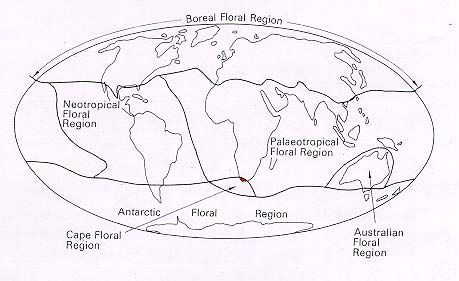
Floral Kingdoms
At a global scale the vegetation of the world is
sometimes described in terms of six Floristic Regions,
often called the Floral Kingdom of the world. The
distinction between regions is based on distinctive suites
of flowering plants, taking into account those (particularly
families) that are exclusive (endemic) to the region.
Confined to South Africa is one of these distinct
kingdoms; the Cape Floral Kingdom, covering 0.08% of
the world's land surface, but containing about 3% of the
world's plant species. For more information about the
Cape Floral Kingdom, see Fynbos Biome below.
Biomes
Groupings called Biomes (large-scale biotic communities) have been described for plants and/or animals living
together with some degree of permanence, so that large-size patterns in global plant cover can be observed.
Biomes broadly correspond with climatic regions, although other environmental controls are sometimes
important. Each biome has a characteristic set of plant and animal species as well as a characteristic overall
physiognomy (for example a general appearance given by the plant shapes). The general plant characteristics
give a characteristic visual signature to the vegetation of the biome. Rutherford and Westfall (1994) map seven
biomes of South Africa: Savanna, Thicket, Grassland, Forest, Fynbos, Nama Karoo, Succulent Karoo and
Desert. See Low and Rebelo (1996) for more information. The description here comes from their web site
below [with some editorial changes]. The most recent treatise on the Biomes of South Africa was published in
2006 by Mucina and Rutherford.
Veld types
John Acocks traveled very widely throughout South Africa during a 40-year period and sampled some 3300
different sites, meticulously recording plant species at the various sites. He described vegetation patterns at a
scale that is still smaller than the biome. He described 70 Veld Types in South Africa, Lesotho and Swaziland.
One can refer to Acocks' book Veld Types of South Africa for the descriptions together with photographs,
species compositions, and some other characteristics of each veld type. [Veld (pronounced ‘felt’) is the South
African term for the natural vegetation, landscape or countryside. It is also used informally in the same way we
would say field, as “we are going into the field this afternoon.”]
Further Reading
Acocks, J.P.H. 1988. Veld Types of South Africa Memoirs of the Botanical Survey of South Africa 57: 1-146.
Cowling, R.M., Richardson, D.M. & Pierce, S.M. 1997, Vegetation of Southern Africa. Cambridge University Press,
Cambridge, UK.
Low, A.B. & Rebelo,A.G. (eds.) 1996, Vegetation of South Africa, Lesotho and Swaziland. Pretoria: DEAT. This
publication is available online at :http://www.ngo.grida.no/soesa/nsoer/Data/vegrsa/vegstart.htm
Mucina, L. and Rutherford, M.C. (eds.). 2006. The Vegetation of South Africa, Lesotho and Swaziland. Strelitizia 19.
South African National Biodiversity Institute, Pretoria, South Africa. (808 pp with CD GIS-database)
Rutherford, M.C. & Westfall, R.H. 1994. Biomes of southern Africa: an objective characterization. Memoirs of the
Botanical Survey of South Africa 54: 1 -98.
1Savanna Biome
The Savanna Biome is the largest Biome in southern Africa, occupying 46% of its area, and over one-
third the area of South Africa. It is well developed over the lowveld
and Kalahari region of South Africa and is also the dominant
vegetation in neighboring Botswana, Namibia and Zimbabwe.
It is characterized by a grassy ground layer and a distinct upper
layer of woody plants. Where this upper layer is near the ground the
vegetation may be referred to as Shrubveld (see also Thicket Biome
below), where it is dense as Woodland, and the intermediate stages
are locally known as Bushveld. This is a dominant vegetation type
at the Great Fish River Reserve GFRR where we will be staying:
see http://www.ngo.grida.no/soesa/nsoer/Data/vegrsa/vegstart.htm
for details.
The environmental factors delimiting the biome are complex: altitude ranges from sea level to 2,000
m; rainfall varies from 235 to 1,000 mm per year; frost may occur from 0 to 120 days per year; and
almost every major geological and soil type occurs within the biome. A major factor delimiting the
biome is the lack of sufficient rainfall which prevents the upper tree layer from dominating, coupled
with fires and grazing, which keep the grass layer dominant. Summer rainfall is essential for grass
dominance, which, with its fine material, fuels near-annual fires. In fact, almost all species are adapted
to survive fires, usually with less than 10% of plants, both in the grass and tree layer, killed by fire.
Even with severe burning, most species can re-sprout from the stem bases.
The grass layer is dominated by C 4-type grasses, which are at an advantage where the growing season
is hot. But where rainfall has a stronger winter component, C 3-type grasses dominate.
The shrub-tree layer may vary from 1 to 20 m in height, but in Bushveld typically varies from 3 to 7 m.
The shrub-tree element may come to dominate the vegetation in areas which are being overgrazed.
Most of the savanna vegetation types are used for grazing, mainly by cattle or game. In the
southernmost savanna types, goats are a major stock. In some areas crops and subtropical fruit are
cultivated. These mainly include the Clay Thorn Bushveld, parts of Mixed Bushveld, and Sweet
Lowveld Bushveld.
Conservation status of savanna is comparatively good, mainly due to the presence of the Kruger and
Kalahari Gemsbok National Parks within the biome. Similarly, in neighbouring countries, large
reserves occur, such as Etosha, Gemsbok, Chobe and Hwange National Parks and the Central Kalahari
Game Reserve. However, the high area conserved in South Africa, belies the fact that half of savanna
vegetation types are inadequately conserved, in having less than 5% of their area in reserves. However,
much of the area is used for game-farming and can thus be considered effectively preserved, provided
that sustainable stocking levels are maintained. The importance of tourism and big game hunting in the
conservation of the area must not be underestimated.
2Thicket Biome
The Thicket Biome has only been recently recognized in the scientific literature. Thicket vegetation
occurs instead of forest where there is a degree of fire protection, but
rainfall is too low to support forests. Thickets do not have the
required height to be classified as forests, and the strata below the
canopy is poorly developed. Nor are they a "Savanna" type, in that
there is no conspicuous grassy ground layer.
Subtropical thicket is a closed shrubland to low ‘forest’ dominated by
evergreen, sclerophyllous or succulent trees, shrubs and vines, many
of which have stem spines. It is often almost impenetrable, is
generally not divided into strata, and has little herbaceous cover.
Because the vegetation types within the "Thicket Biome" share
floristic components with many other vegetation types and are often transitional to other biomes types,
Thicket types have been referred to as "transitional thicket". Thicket types contain few endemics, most
of which are succulents of Karoo origin(e.g. plakkies Crassula spp. and sheep fig Delosperma spp.). A
complete list of characteristic species of subtropical thicket and subdivisions into different types can be
found in Everard (1987). The Thicket biome is also well developed at the Great Fish River Reserve,
and Addo Elephant Park.
At least five Thicket types are recognized on the basis of their distribution and the degree of
succulence in the shrub and tree species: Dune Thicket, Valley Thicket, Xeric Succulent Thicket,
Mesic Succulent Thicket and Spekboom Succulent Thicket. See:
http://www.ngo.grida.no/soesa/nsoer/Data/vegrsa/thicbiom.htm for more details.
Grassland Biome
The Grassland Biome is found chiefly on the high central plateau of South Africa, and the inland areas
of KwaZulu-Natal and the Eastern Cape. The topography is mainly
flat and rolling, but includes the escarpment itself. Altitude varies
from near sea level to 2,850 m above sea level. Grassland vegetation
types can be found within driving distance of GFRR but not in the
reserve.
Grasslands (also known locally as Grassveld) are dominated by a
single layer of grasses. The amount of cover depends on rainfall and
the degree of grazing. Trees are absent, except in a few localized
habitats. Geophytes (bulbs) are often abundant. Frosts, fire and
grazing maintain the grass dominance and prevent the establishment
of trees.
There are two categories of grass plants: sweet grasses have a lower fiber content, maintain their
nutrients in the leaves in winter and are therefore palatable to stock. Sour grasses have a higher fiber
content and tend to withdraw their nutrients from the leaves during winter so that they are unpalatable
to stock and have low nutritional value. At higher rainfall and on more acidic soils, sour grasses
3prevail, with 625 mm per year taken as the level at which unpalatable grasses predominate. C4 grasses
dominate throughout the biome, except at the highest altitudes where C3 grasses become prominent.
Grass plants tolerate grazing, fire, and even mowing -- most produce new stems readily, using a wide
variety of strategies. Overgrazing tends to increase the proportion of pioneer, creeping and annual
grasses, and it is in the transition zones between sweet and sour grass dominance that careful
management is required to maintain the abundance of sweet grasses. The Grassland Biome is the
mainstay of dairy, beef and wool production in South Africa. Pastures may be augmented in wetter
areas by the addition of legumes and sweet grasses.
Much of the Grassland Biome has been converted to corn production. Sorghum, wheat and sunflowers
are also farmed on a smaller scale.
Urbanization is a major additional influence on the loss of natural areas - the Witwatersrand (Greater
Johannesburg) is centered in this biome. The Grassland Biome is considered to have an extremely high
biodiversity, second only to the Fynbos Biome. Rare plants are often found in the grasslands,
especially in the escarpment area. These rare species are often endangered, comprising mainly endemic
geophytes or dicotyledonous herbaceous plants. Very few grasses are rare or endangered.
Forest Biome
Forests are restricted to areas with mean annual rainfall of more than 525mm in the winter rainfall
region and more than 725 mm rainfall in the summer rainfall region.
They occur from sea level to over 2100m above sea level. At higher
elevations they may be limited by the extended frost season. Forests
rarely burn, mainly due to the high humidity - under extremely hot and
dry (berg wind) conditions fires may occur and destroy the forest
structure.
Forests tend to occur in patches, few of which cover areas greater than
1 km 2, with areas greater than this only common along the South Coast
and Lowveld Escarpment. Even added together, forests cover less than
0.25% of southern Africa's surface area, making this the smallest
biome on the subcontinent, and the smallest temperate forest biome in the world. We will visit forests
nearby GFFR at Hogsback Mountain (montane forest) and along the coast of the Indian Ocean.
The canopy cover of forests is continuous, comprising mostly evergreen trees, and beneath it the
vegetation is multi-layered. Herbaceous plants, particularly ferns, are only common in the montane
forests, whereas lianas and epiphytes are common throughout. The ground layer is often poor
developed due to the dense shade. On the edges of the patches are distinctive communities, the so-
called fringe or ecotonal communities, which are able to tolerate fire.
More than 649 woody and 636 herbaceous plant species are recorded from forests. However, forests
are not floristically uniform. Three separate forest types are recognized in this account. Specialized
forests that occur in small areas and very sporadically - such as mangrove, swamp and fringe forests
are not separated from these three types.
4Partly because of their rarity, their grandeur and their setting, forests are an important in South Africa.
They have been exploited in the past for valuable timber, including Black Stinkwood Ocotea bullata
and Outeniqua Yellowwood Podocarpus falcatus. Some forests were removed for the establishment of
exotic tree plantations (e.g. pines, Eucalyptus). A major plant invader of forests is Blackwood Acacia
melanoxylon.
Forest conservation has two facets: the maintenance of components and critical processes in the forests
- which requires the conservation of the large mammals and birds which disperse seeds and maintain
gap processes which allow succession within the forests - and the maintenance of gene flow - which
requires allowing seed dispensers and pollinators to move along the corridors between forest patches.
Thus the proclamation of isolated stands of forests as reserves may be insufficient for their
conservation. Sustainable use of forests may require that their fauna be effectively conserved!
Fynbos Biome
The Fynbos Biome is considered by many to be synonymous with the Cape Floristic Region or Cape
Floral Kingdom. However, the "biome" refers only to two key vegetation types (Fynbos and
Renosterveld) within the region, whereas both the "region" and the "kingdom" refer to the general
geographical area and include other vegetation types in the Forest, Nama Karoo, Succulent Karoo and
Thicket Biomes, but exclude peripheral outliers of the Fynbos and Grassy Fynbos east of Port
Elizabeth (and near GFRR). However, the contribution of Fynbos vegetation to the species richness,
endemicity and fame of the region is so overwhelming, that the Cape Floristic Region and Cape Floral
Kingdom can be considered to be "essentially Fynbos."
The Cape Floral Kingdom is the smallest of the six Floral Kingdoms in the world, and is the only one
contained in its entirety within a single country. It is characterized by its high richness in plant species
(9000 species) and its high endemicity (68% of plant species are confined to the Cape Floral
Kingdom). The Cape Floral Kingdom thus compares with some of the richest floras worldwide,
surpassing many tropical forest regions in its plant diversity.
In South Africa, over one third of all plant species occur in the Cape Floral Kingdom, even though the
Kingdom occupies less than 6% of the area of the country. This is not primarily due to the large
number of vegetation types in the Cape Floral Kingdom. Over 7,000 of the plant species occur in only
five Fynbos vegetation types, with perhaps an additional 1,000 species in the three Renosterveld
vegetation types. The contribution of Succulent and Nama Karoo, Thicket and Forest vegetation types
in the region to the plant species diversity is thus relatively small. Thus, although the Cape Floral
Kingdom contains five biomes, only the Fynbos Biome, comprising the Fynbos and Renosterveld
vegetation groups, contains most of the floral diversity. Furthermore, the Cape Floral Kingdom
traditionally does not include the Fynbos and Renosterveld vegetation outliers to the north and east.
Including these would mean that endemicity would approach 80%, the highest level of endemicity on
any subcontinent.
Distressingly, some three-quarters of all plants in the South African Red Data Book occur in the Cape
Floral Kingdom: 1,700 plant species are threatened to some extent with extinction! This is much more
than one would expect based on either the area of the Kingdom (6%) or its plant numbers (36%). This
again reflects the unique nature of Fynbos vegetation: many Fynbos species are extremely localized in
their distribution, with sets of such localized species organized into "centers of endemism." The city of
Cape Town sits squarely on two such centers of endemism and several hundred species are threatened
5by urban expansion. However, a more serious threat is alien plants, which infest large tracts of
otherwise undisturbed mountains and flats: their impact on these extremely localized species is severe.
Aliens are thus the major threat to Fynbos vegetation and its plant diversity, especially in the
mountains. On the lowlands and on the less steep slopes the major threat is agriculture - new
technologies, fertilizers and crops are steadily eating into our floral reserves. Another important threat
is the misuse of fire. Fynbos must burn, but fires in the wrong season (such as in spring, instead of late
summer) or too frequently (so that plants do not have time to set seed) eliminate species. Several
factors influence fire dynamics in Fynbos - global warming, grazing practices and fire management
(ignition events, size of burns), but their relative importance and interactions are poorly understood.
The two major vegetation groupings in Fynbos are quite distinct and have contrasting ecological
systems. Essentially, Renosterveld used to contain the large animals in the Cape Floristic Kingdom,
but these are now extinct or else have been reintroduced into conservation areas. By contrast, Fynbos is
much richer in plant species, but has such poor soils that it cannot support even low densities of big
game. However, most of the endemic amphibian, bird and mammal species in the region, occur in
Fynbos vegetation types. Key references: Bond & Goldblatt (1984), Hall & Veldhuis (1985), Cowling
(1992), Rebelo (1994), Cowling & Richardson (1995).
Renosterveld
Renosterveld (literally Rhinoceros veld) is characterized by the dominance of members of the Daisy
Family (Asteraceae), specifically one species - Renosterbos
(Rhinoceros bush) Elytropappus rhinocerotis, from which the
vegetation type gets its name. Although Renosterbos is the
characteristic dominant, many other plants are also prominent - for
instance in the Daisy Family (Asteraceae): Eriocephalus, Felicia,
Helichrysum, Pteronia, Relhania; Pea Family (Fabaceae): Aspalathus;
Gardenia Family (Rubiaceae): Anthospermum; Cocoa Family
(Sterculiaceae): Hermannia; Thyme Family (Thymelaeaceae):
Passerina. All these shrubs are characterized by their small, tough, grey
leaves.
Grasses are also abundant. In fact, it is alleged that the high shrub cover is a result of continuous
grazing. Early records suggest that the Renosterveld had abundant grasses, and that the game and Khoi
cattle migrated over the region. With the establishment of European stock farmers, continuous grazing
and the elimination of the diverse grazing-browsing fauna, the shrubby element was promoted. This
theory is not universally accepted, but proponents argue to the sudden decline of hay near Cape Town
in the early 1700s, and the many historical records of early explorers claiming that Renosterbos was
taking over and that grass was becoming scarce.
Another feature of Renosterveld is the high species richness of bulb or geophytic plants (chiefly in the
Iris Family (lridaceae) and Lily Family (Liliaceae), but also in the Orchid Family (Orchidaceae)).
Proteas, Ericas and Restios - typical of Fynbos - tend to be absent in Renosterveld, or are present at
very low abundances. There are few endemics to Renosterveld vegetation alone, many of the species
occurring in Fynbos as well. However, species endemic to the Cape Floral Kingdom comprise about
one-third of Renosterveld plant species, and many of these belong to families which are not considered
to be of "Cape affinity" (i.e. these families are also diverse outside the Cape Floral Kingdom).
6Typically, Renosterveld is largely confined to fine-grained soils - mainly clays and silts - which are
derived from the shales of the Maimesbury and Bokkeveld Groups and the Karoo Sequence. In drier
regions it also occurs on Cape Granite Suite-derived soils. Because all these soils are fertile, much of
Renosterveld has been ploughed for wheat production.
Renosterveld tends to occur where rainfall is between 250 (rarely to 200 mm) to 600 mm per year and
at least 30% falls in winter. Where the rainfall is higher, the soils become leached and Renosterveld is
replaced by Asteraceous Fynbos. Generally, where the rainfall is less than 250 mm, it is replaced by
one of the Succulent Karoo vegetation types.
Because of its high soil fertility, it is probable that all the herds of large game in the Fynbos Biome
occurred in Renosterveld. Thus Mountain Zebra, Quagga, Bluebuck, Red Hartebeest, Eland, Bontebok,
Elephant, Black Rhino and Buffalo were common, as were Lion, Cheetah, Wild Dog, Spotted Hyena
and Leopard. Two of these only ever occurred within the Fynbos Biome: Bluebuck and Bontebok. Of
these large mammals, only the Mountain Zebra and Leopard survived (by fleeing to the mountains),
with the Bontebok just surviving in one locality. All the other species became extinct in the Fynbos
Biome (one elephant survives in the Forest Biome within the Fynbos Biome area), although many have
been introduced into conservation areas from outside the region. The Quagga and Bluebuck are extinct.
This high fertility has meant that most of the area has been converted to agriculture. Less than 5% of
West Coast Renosterveld remains (the Rio Convention has as its goal the preservation of 10%!), with
other Renosterveld types also heavily ploughed or used as augmented pasture. It seems unlikely that
viable populations of large mammals will ever be reintroduced into the Fynbos Biome for this reason.
Fynbos
The various Fynbos vegetation types comprise most of the area of the Fynbos Biome. Fynbos is
characterized by the presence of the following three elements:
1. A restioid component, belonging to the Restionaceae or the Cape
Reed Family. Some definitions require a mere 5% cover of restiods
in an area to classify it as a Fynbos vegetation type. The
Restionaceae have been described as shrubby grasses, and replace
grasses on nutrient-poor soils where there is a strong winter
component to the annual rainfall. Sedges and many grasses within
Fynbos also share the "restioid" characters of reduced or absent
leaves and tough, wiry stems.
2. An ericoid or heath component. By far the majority of plant
species - and the greatest cover after restioids comprise plants with
small, narrow, rolled leaves with thick-walled cells on the upper leaf surface and a channel containing
hairs on the lower surface. Although the Heaths (Ericaceae) feature prominently, the Daisy
(Asteraceae), Blacktip (Bruniaceae), Pea (Fabaceae), Jujube (Rhamnaceae) and Thyme
(Thymelaeaceae) Families also have structurally similar leaves. Many of these plants are wispy and
insubstantial, although some form quite dense bushes.
73. A proteoid component. These plants, almost exclusively of the Proteaceae, have broad, isobilateral
(both surfaces similar) leaves. They are the dominant overstorey in Fynbos. Although some members
occur in ecotones and some occur in Renosterveld, by far the majority are confined to Fynbos.
Fynbos is characterized by the presence of seven endemic or near-endemic plant families: Blacktips
(Bruniaceae), Guyalone (Geissolomaceae), Sillyberry (Grubbiaceae), Brickleaf (Penaeaceae), Buttbush
(Retziaceae), Dewstick (Roridulaceae) and Candlestick (Stilbaceae). Only the Bruniaceae (75 spp.),
Penaeaceae (21 spp.) and Stilbaceae (13 spp.) comprise more than five species. The fifteen largest
families comprise 70% of the species in the Fynbos Biome
Over 7,000 plant species occur in the Fynbos vegetation types. Endemicity is very high - over 80% of
plant species are confined to the Cape Floral Kingdom and Fynbos Biome. The majority of these,
although exact numbers are unknown, are confined to one or more of the various Fynbos vegetation
types.
Many species have very narrow distributional ranges. Thus, based on the Proteaceae for which we
have the most finely detailed data, some 24 centres of endemism (areas with species sharing similar
localized distributional ranges) have been identified.
Whereas there is near unanimity as to the definition of Fynbos as a unit, there are widely divergent
opinions on the major vegetation types within Fynbos. This stems from the high species richness and
the large number of localized species, which prevents an easy comparison of species lists between
centres of endemism. Consequently, the definition of vegetation types based on species composition,
the basis for determining types in the other biomes, has never been achieved in Fynbos.
A structural approach, suggested by Campbell in 1985, recognises Proteoid, Ericaceous, Restioid,
Asteraceous, Shrubby and Grassy vegetation types. This approach denies a difference in Fynbos types
between the mountains and the lowlands of the Biome. However, the different types occur on a scale
too fine to map here Ericaceous on the wet, upper south slopes, Asteraceous on the drier northern
slopes and the wetter, shale-derived soils, Restioid on the winter water-logged and summer and slopes,
and Proteoid on the richer colluvial, sandstone-derived soils. Shrubby Fynbos is ecotonal to forest
where rock outcrops, gorges and stream courses protect the vegetation from fires, and Grassy Fynbos
predominates where the summer component of the rainfall allows grasses to outcompete the restioids.
These basic components are further subdivided into over 60 types based on structural adaptations.
An older classification by Moll & Bossi in 1983, recognized three main types of Fynbos. These are
Mountain, Grassy and Lowland Fynbos. The Grassy type corresponds to that of Campbell. However,
the Mountain and Lowland dichotomy has never been defined or defended. It has been criticised as
merely one of cartographic convenience. Mountain Fynbos was classified into Dry, Mesic and Wet
Fynbos, with a fourth type - Arid (for the northern Cederberg and Swartberg) - perhaps required.
Grassy Fynbos was categorized as either Mesic (on southern slopes and nearer the coast) or Dry
(northern slopes and predominantly inland). Lowland Fynbos was subdivided into three main types
based on their edaphic (soil) requirements. Of the three, only the subdivisions of the Lowland Fynbos
types correspond to mapable patterns of endemism and are adopted here (the other units were
recognized on LANDSAT satellite imagery, but do not correspond to structural vegetation type
classes).
8Fynbos vegetation types occur predominantly on well-leached, infertile soils. The Cape Supergroup
sandstones typically produce such soils, but under high rainfall conditions, granites and even shales
become sufficiently leached to support Asteraceous Fynbos, replacing Renosterveld. This usually
occurs at about 600 to 800 mm annual rainfall, but may be much less on granites, especially at higher
altitudes. Below 200 mm Fynbos is replaced by Succulent Karoo, presumably because at such low
rainfall, the vegetation does not burn frequently enough.
Fynbos has a low animal biomass, although species richness of birds, mammals, frogs, reptiles and
insects is quite high, and most Fynbos Biome endemics occur in Fynbos vegetation types. Although
these animals play a major role in pollination and seed dispersal, they appear to play a minor part in
influencing vegetation structure and composition. This is partly due to the high carbon to nitrogen
ratio, which effectively excludes browsing of all but the youngest leaves.
Fire is a major influence on Fynbos community processes. Fynbos must burn at between 6 and 45
years of age in order to sustain its plant species. Many species store their fruit in fire-safe cones for
release after a fire, and ants are enticed to bury fruit where they are safe from rodents and fire. After
fire many plant species resprout, but the majority rely on the predictability of fires and only regenerate
after the fire from seeds. Without fire, Fynbos becomes senescent and Forest and Thicket elements
begin invading.
Because of the low productivity of Fynbos vegetation types, due to the infertile soils, they are little
utilized for agriculture. The major use of Fynbos is for recreation, water catchment and exotic
plantations. In some areas vegetation harvesting for the cut-flower trade occurs, and wild flower
orchards are being established in Fynbos areas. The implications of these for hybridization and gene
transfer are-poorly understood and are of conservation significance - we need to conserve the genetic
material for future cultivar selections rather than lose wild genetic reserves by careless orchard
placement. On richer soils where the rainfall is high, Fynbos has been converted to fruit orchards and
vineyards. With more modern agricultural techniques (liquid fertilisation, terracing, hydroponics)
much marginal land is becoming suitable for agriculture. At present dam building - both for
agricultural and urban use - is a threat, albeit a minor one, compared with alien encroachment,
urbanization and fires.
9Nama Karoo Biome
The Nama Karoo Biome occurs on the central plateau of the western half of South Africa, at altitudes
between 500 and 2000m, with most of the biome falling between 1000 and 1400m. It is the second-
largest biome in the region. There are areas of Nama Karoo near
GFRR.
The geology underlying the biome is varied, as the distribution of this
biome is determined primarily by rainfall. The rain falls in summer, and
varies between 100 and 520mm per year. This also determines the
predominant soil type - over 80% of the area is covered by a lime-rich,
weakly developed soil over rock. Although less than 5% of rain reaches
the rivers, the high erodibility of soils poses a major problem where
overgrazing occurs.
The dominant vegetation is a grassy, dwarf shrubland. Grasses tend to be more common in depressions
and on sandy soils, and less abundant on clayey soils. Grazing rapidly increases the relative abundance
of shrubs. Most of the grasses are of the C-4 type and, like the shrubs, are deciduous in response to
rainfall events.
The amount and nature of the fuel load is insufficient to carry fires and fires are rare within the biome.
The large historical herds of Springbok and other game no longer exist. Like the many bird species in
the area - mainly larks - the game was probably nomadic between patches of rainfall events within the
biome. The Brown Locust and Karoo Caterpillar exhibit eruptions under similarly favourable, local
rainfall events, and attract large numbers of bird and mammal predators.
10Less than 1% of the biome is conserved in formal areas. The Prickly Pear Opuntia aurantiaca and
Mesquite Prosopis glandulosa (both introduced from the US) are the major alien invader species.
Urbanization and agriculture are minimal, and irrigation is confined to the Orange River valley and
some pans. Most of the land is used for grazing, by sheep (for mutton, wool and pelts) and goats,
which can be commensurate with conservation. However, under conditions of overgrazing, many
indigenous species may proliferate, including Threethorn Rhigozum trichotomum, Bitterbos
Chrysocoma ciliata and Sweet Thorn Acacia karroo, and many grasses and other palatable species
may be lost. There are very few rare or Red Data Book plant species in the Nama Karoo Biome.
Succulent Karoo Biome
The Succulent Karoo Biome has an equal status to the other biomes in South Africa - it is not a subtype
of "a Karoo Biome."
Most of the biome covers a flat to gently undulating plain, with some
hilly and "broken" veld, mostly situated to the west and south of the
escarpment, and north of the Cape Fold Belt. The altitude is mostly
below 800 m, but in the east it may reach 1 500 m. A variety of
geological units occur in the region. There is little difference between
the soils of the Succulent Karoo and Nama Karoo Biomes - both are
lime-rich, weakly developed soils on rock. The Olifants and Doring
Rivers are the major drainage systems in the west, with the Gouritz
River in the south-east of the biome.
The Succulent Karoo Biome is primarily determined by the presence of low winter rainfall and
extreme summer aridity. Rainfall varies between 20 and 290 mm per year. Because the rains are
cyclonic, and not due to thunderstorms, the erosive power is far less than of the summer rainfall
biomes. During summer, temperatures in excess of 40°C are common. Fog is common nearer the coast.
Frost is infrequent. Desiccating, hot, Berg Winds may occur throughout the year.
The vegetation is dominated by dwarf, succulent shrubs, of which the Vygies [ice-plants]
(Mesembryanthemaceae) and Stonecrops (Crassulaceae) are particularly prominent. Mass flowering
displays of annuals (mainly Daisies Asteraceae) occur in spring, often on degraded or fallow lands.
Grasses are rare, except in some sandy areas, and are of the C3 type. The number of plant species
mostly succulents - is very high and unparalleled elsewhere in the world for an arid area of this size.
Little data are available for the fauna of the Succulent Karoo. Of importance in the area are
heuweltjies, raised mounds of calcium-rich soil, thought to have been created by termites. These often
support distinctive plant communities.
The area has little agricultural potential due to the lack of water. The paucity of grasses limits grazing,
and the low carrying capacity requires extensive supplementary feeds. Much soil has been lost from
the biome, through sheet erosion, as a consequence of nearly 200 years of grazing. Ostrich farming,
with considerable supplementary feeding, is practiced in the Little Karoo in the south of the biome. In
areas adjoining the Fynbos Biome, wine grapes, fruit and other crops are cultivated using the Fynbos
water catchments. Tourism is a major industry: both the coastal scenery and the spring mass flower
displays are draw cards. Mining is important, especially in the north.
11Less than 0.5% of the area of the Succulent Karoo Biome has been formally conserved, but a national
park has recently been established. The biome has a high number of rare and Red Data Book plant
species. The high species richness and unique global status of the biome require urgent conservation
attention. Fortunately, there are few invasive alien plants, with only Rooikrans (Acacia cyclops) a
major problem in the southern coastal regions. Strip-mining for diamonds is destructive in the northern
coastal regions, and legislation requiring revegetation of these areas is inadequate for near-desert
conditions.
Extreme Desert biome
“True” desert is found under very harsh environmental conditions which are more extreme than those
found in the Succulent Karoo Biome and Nama-Karoo Biome. The climate is characterized by
occasional summer rainfall, but high levels of summer aridity. Mean annual rainfall is from
approximately 10mm in the west, to 70 or 80mm on the inland margin of the desert. In reality, the
rainfall is highly variable from year to year. Most true desert in southern Africa is found in Namibia,
although an outlier does occur in a small part of South Africa, mainly in the Springbokvlakte area of
the Richtersveld in the lower Orange River valley.
The vegetation of the Desert Biome is characterized by dominance of annual plants (often annual
grasses). This means that after a season with rarely abundant rains, the desert plains can be covered
with a sea of short annual grasses. Whereas in more normal years, the plains can appear bare with the
annual plants persisting in the form of seed.
Perennial plants are usually encountered in specialized habitats associated with local concentrations of
water. Common examples of these are broad drainage lines or washes. The well-known, odd shrub,
Welwitschia mirabilis, of the Namib Desert, occurs in such areas. The perennial grass, Stipagrostis
sabulicola, occurs sporadically on large dunes which contain substantial stores of water. Nearer the
coast in Namibia, the role of coastal fog also governs distribution of certain species commonly
associated with the desert. Daily fog is the only dependable source of moisture in these “fog deserts”.
The Desert Biome includes an abundant insect fauna which includes many tenebrionid beetles, some of
which can utilize fog water.
[The text has been edited and annotated from National Botanical Institute, South Africa
web site: http://www.plantzafrica.com/vegetation/vegmain.htm]
12You can also read