The Roman 'Roadline Settlement' at Cheshunt Park Farm, Hertfordshire: A Review of the Evidence
←
→
Page content transcription
If your browser does not render page correctly, please read the page content below
Enfield Archaeological Society Occasional Research Note No. 1

    The Roman ‘Roadline Settlement’ at Cheshunt Park Farm,
           Hertfordshire: A Review of the Evidence
                                                     Martin J. Dearne

Introduction

The small Roman settlement at Cheshunt Park Farm (TL 344 042) lies on the line of Ermine Street, the main
Roman road running north from Londinium along the Lea valley, between two other known ‘roadline
settlements’1 at Bush Hill Park, Enfield and Ware (Fig. 1). It is poorly known from unpublished excavations and
survey work in the 1950s and 1960s and then in the early twenty first century. The former were carried out by
individuals with no archaeological experience so that, along with the limited survival of the finds, they are now
difficult to interpret. However, the site is sufficiently important as one of the small settlements that grew up along
this major Roman road to justify reviewing what can be established about it. This review is based on an analysis
(Dearne et al 2010) by the author, Neil, John and Lesley Pinchbeck and Roger Dormer of the archive left by one
of the early excavators, Tom Howlett (Herts County Record Office D/EHW23 Cheshunt Park Roman Site 1957-
61), of photographic and plan evidence held by the Enfield Archaeological Society2 and of the surviving finds in
the Lowewood Museum, Hoddesdon,3 together with the unpublished reports on the later work by and for Channel
4’s Time Team programme in 2001 (Ely and Edwards 2003; GSB Prospection 2001; Wessex Archaeology
(2002)), and the site archive generated by that work.4

Fig. 1: Cheshunt Park Farm in Relation to the Road Network and (Quasi-)Urban Sites in South East England

1
  For a discussion of the terminology used of small settlements on Roman roads see Dearne (2017) 318f.
2
  Largely deriving from the archive of the late Geoffrey Gillam, but including copies of photographs taken by and a plan reflecting the
recollections of Jean Mullinger, acquired though the good offices of Brian Hornby.
3
  Examined by kind invitation of Neil Robbins, then the curator of the museum.
4
  Held by the Lowewood Museum and consulted again by kind permission of Neil Robbins.
                                                                  1
The early excavations from ?1954 – 1969 were undertaken by the ‘Cheshunt Park Archaeological Group’,
comprising Tom and Jean Mullinger, Tom Howlett and their friends and families. None had any archaeological
training and, despite the efforts of John Kent of the British Museum, Ilid Anthony of St. Albans Museum and
Geoffrey Gillam of the Enfield Archaeological Society, only limited systematisation could be introduced into
even the later stages of the work, for which permission was given by Phyllis Debenham, the owner of the (now
demolished) Cheshunt Park House and the surrounding farm.5 In all over 100 (relatively small) separate ‘trenches’
of one sort or another were cut during this period across a wide area, but mainly focused in what were then known
as Pump Meadow and The Orchard (Fig. 2). Nothing is known of those cut before 1957 and little of value is
recorded of many subsequent ones, but it is possible to assess some elements of the work undertaken in 1961 –
1964, mainly in an area that was (partly and haphazardly) excavated within a ‘box grid’, so that what recording
there was can be evaluated to an extent. Subsequent excavation here and nearby by Time Team
confirmed/augmented some of the records of this work, however, it should be emphasised that the 1960s records
primarily drawn on here are still very incomplete, ‘amateurish’ and problematic, reflecting excavation by
individuals with little comprehension of the importance of stratigraphy, the nature of the archaeological method
or the importance of accurate record making. Indeed, trench positions and relationships are often in some doubt,
excavations in the ‘box gridded’ area subsumed some earlier trenches (not shown on figures) and what is shown
on figures are often slightly simplified ‘best fit’ approximations from inadequate records. 6
The Settlement
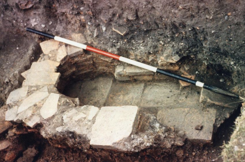
The exact line of Ermine Street at this point is not certain, but possible roadside ditches located by Time Team
suggest that it lay around 30 m east of the 1960s box grid work (Fig. 2), while another Time Team trench c. 15 m
closer to the roadline identified a basic tessellated floor of cut tile possibly associated with a beam slot (Fig. 3;
Pl. 1). Other than Structures 1 and 2 described below, this is the only specific structural evidence for which
reliable records are available, but elsewhere in the ‘box gridded’ area and to its east there are sufficient 1960s
and Time Team records of e.g. possible surfaces, cbm scatters, cut features and indications of burning to be
reasonably confident that there was occupation of some sort across something like a 25 - 30 m2 area (Fig. 4) and
activity covered probably 50 m2 at least.
Pl. 1: Time Team Excavation of the Tessellated Floor (Photo, EAS Gillam Archive)
5
The site is now in the ownership of Cheshunt Borough Council.
6
Reconciliation of the location of 1960s work with Time Team trenches is also problematic and should not be relied on in detail.
2
Bruce’s             Meadow

                              FARM

                                                    Orchard

                                               Vegetable
                                                Garden

             Pump Meadow
                                Fig. 3
                                                CHESHUNT
                                               PARK HOUSE

                                                      Cheshunt
                                                        Park

                 N                                  Mappable 1950s/60s
                                                    Trenches
                                                    Time Team
                                                    Trenches

                                           0                  100
                                                    m

Fig. 2: Mappable Excavation Trenches in Relation to 1960s Site Features

                                  3
Tessellated Floor
      0               10

              m                          N                              ‘Box Grid’ Area

                                                                         Extent of 1960s Excavations
                                                                         (Approximate)

                                                                         Time Team Trenches

             Fig. 3: Excavations in and Around the 1960s ‘Box Grid’ Area (for Location see Fig. 2)

Gradiometry carried out for Time Team (GSB Prospection 2001) and validated by their excavations strongly
suggests that there was a rectilinear ditched enclosure west of Ermine Street at this point with two southern
entrances. Though the excavators interpreted this as part of ‘an earlier brickwork pattern of field boundaries that
cover Cheshunt, Broxbourne and Wormley’ on an alignment unrelated to Ermine Street (Ely and Edwards 2003,
15), this seems to be contradicted by projections of the line for the road based on their work (Fig. 4). Moreover,
they recovered a later first/second century necked jar from the fill of the primary ditch cut here and a partially
complete third or fourth century BB1 jar from the fill of a ?recut (Wessex Archaeology (2002, 2); Ely and Edwards
(2003, 14f)). This seems to question the enclosure belonging to the putative prehistoric co-axial field system with
later subdivision proposed and studied by Bryant et al (2005), who (op cit, 13 f) cite the assertion that the enclosure
alignment is unrelated to Ermine Street as evidence for the date of the putative system. Ely and Edwards’ (2003,
15) suggestion that the original ditch was filled when the settlement was established and a later ditch was cut on
exactly the same line following some (unevidenced) settlement contraction also seems less likely than that the
enclosure ditch defined the Cheshunt Park Farm settlement throughout its existence. Though the records are poor,
the 1960s work also suggests the presence of further ditches parallel to, but east of, the western side of the
gradiometry detected enclosure (Fig. 4). One might then postulate that the (?subdivided) enclosure (?c. 75 m east
west and at least 27 m north south) demarked the formal limits of the Roman settlement, perhaps with its western
part less settled as a scatter of possible pits here and west of the enclosure were suggested by the gradiometry.

                                                          4
??Ditch
                  ?Ditch

                                                  Structural/Occupation
                                                    Evidence Present

                                                                        Tessellated
                                                          Structure 1     Floor

                                                            (?Modern) Ditch
                                                              (Time Team)

       0                                        30
                                                            N
                                                                                             ?Roadside Ditches
                           m                                                                   (Time Team)

                                         Fig. 4: Evidence for the Roadline, Enclosure and Occupation

Whether that was the case or not, analysis of surviving finds from the early work at the site appears to suggest a
Flavian start date and continuous activity through to the fourth century. All material has to be treated as unstratified
due to the poor standards and records of the excavations, and what survives is known to only be part of the finds
made (mainly from the box gridded area). However, it includes coins7 of Trajan, M. Aurelius, S. Severus, Tetricus
I, Phillippus Augustus and Maximianus plus possibly the House of Constantine and a ?copy of a Constantinopolis
issue. Approaching 1,000 sherds of pottery represent both fine and coarse wares. Of c. 60 sherds of samian the
earliest are South Gaulish forms 29 and 37 in La Graufesenque fabrics, one of the former perhaps being early
Flavian or just possibly Neronian, while second century activity is represented by Trajanic, earlier and mid to
mid/late second century vessels which include a form 37 in the style of Ioenalis (Rogers’ Potter X-12) of Lezoux.
There is little East Gaulish samian, bar a possible sherd from a ??Form 54/Ludowici Vd-g series beaker, but later
finewares include Nene Valley colour coated ware beakers and some flagons (and perhaps one East Gaulish black
colour coated product), several belonging to the later second to later third centuries and at least one more likely
being fourth century. Mortaria also suggest activity over an extended period, and include a late first/early second
century Brockley Hill vessel stamped by Marinus (c. AD 80 – 125) (see Appendix 1) and a range of Nene Valley,
Colchester and Oxfordshire vessels with, if anything, a preponderance of third and fourth century forms.

Coarseware sources included Highgate Wood (to c. AD 160) and the Verulamium region (though more often in
the red firing, cream slipped fabric introduced c. AD 130 than in their buff granular fabric). From the ?later second
century Alice Holt products also appeared and from the mid third century Much Hadham vessels. Black Burnished
ware was present, but many vessels were in more or less sandy reduced fabrics of unknown origin (though Much
Hadham must be a potential source for some of these greywares), including copies of forms made by e.g. the

7
    Both extant coins and lost ones reliably identified by Dr. Kent.
                                                                          5
Verulamium region industry. In date it seems likely that the assemblage represents continuous activity through
the second, third and fourth centuries. There was only one specifically late first century beaker and one late
first/very early second century vessel (and a few sherds in an Iron Age tradition). But second century jars were
very common and second century bowls present in reasonable numbers. As is usual specifically identifiable third
century vessels were rarer, but present and many low rimmed flanged bowls present probably represented the later
second and third centuries. Other flanged bowls identified would be at home in fourth century contexts and a little
post mid third century Much Hadham oxidised ware as well as vessels such as a jar comparable to Frere (1972,
359) No. 1239 of AD 350 – 410 reinforces the impression of activity well into the fourth century (though few
third and fourth century jars were recognised and few bowls had preserved decoration).

Structural Features in the ‘Box Gridded’ Area

Structure 1
The only structural features excavated in the 1960s in the box gridded area and well enough recorded to do more
than speculate about were two partly or wholly tile built constructions of which the earlier was almost certainly
Structure 1, a small part of which was re-examined by Time Team in 2001 (Ely and Edwards 2003, 13f), though
by then many elements of the structure no longer existed.8

Structure 1 (Pl. 2) is reconstructed in plan on Fig. 5 as far as is now possible from a variety of records, though in
detail at least considerable caution is necessary as records were made haphazardly at different stages of the
deconstruction of built features and with no good understanding of stratigraphic principles. However, it appears
to have been a ‘hypocausted’ building, probably a grain drying shed, overall something like 7.08 m east west and
4.72 m north south, but with its east end narrowed to c. 3.20 m. Much of its limits were indicated by the presence
of a solid floor of closely packed cracked tile fragments and gravel, described by Ely and Edwards (2013, 13) as
a ‘charging layer’, and probably thicker on the north than south. Up to 21 pilae, or at least large tile fragments
that might mark their positions, seem to have been found in this structure, and in its central part one or two
rectangular cobble features (one 0.50 m wide) might also represent improvised pilae bases. The pilae were
founded on a variety of whole and, mainly, part and matched fragments of floor tiles, the (complete) largest of
which (0.40 x 0.29 m) was presumably a lydion tile, but others of which were pedalis tiles/fragments or incomplete
larger tiles. Where surviving, in one case to three courses, the pilae were built of smallish bessalis tiles (0.19 x
0.18 x 0.03 – 0.04 m) above these bases and were fairly regularly positioned if irregularly spaced.

Evidence for the walls of the structure principally consisted of a 0.66 m wide probable foundation trench cut into
(?natural) gravel running along its north side and evidently filled with 0.02 – 0.10 m sized pieces of iron slag
forming a deposit 0.08 m deep, and perhaps similar ‘pockets’ of slag along the east end. However, a ?wall fragment
of cobbles and part tiles seems to have been found at the south west corner and, with one or two other patches of
cobbling, may well suggest mortared cobble and tile fragment dwarf walls for a timber superstructure at least on
the north, east and south. Whether there was any form of wall on the west is unclear, however, tile debris from a
‘black deposit’ just west of the structure seems to have included more floor tiles, but also tegula, imbrex (and
‘hypocaust’) tile fragments, raising the possibility that the structure had a tiled roof.

8
 Ely and Edwards (2003, 14) assert that ‘beam slots were identified within the hypocaust system’, presumably referring to 1960s records
of up to 0.15 m wide north south clay filled ‘channels’, one crossing Structure 1 and one well east of it. However, the stratigraphic level
of these is unclear and one suspects that they represented an ??earlier structure (if they were indeed beam slots) rather than part of
Structure 1. A probable ditch line which may well represent further activity preceding Structure 1 was also recorded in section in the
1960s.

                                                                    6
Mortar

                                                              Tile

                                                              Flint and Tile

                                                              ‘Black Deposits’

Structure 2                                                      Burning
                                                          N

      Fig 5: Composite Plan of Structure 1 and Environs (1:50)

                                   7
The best preserved part of the structure was the at least 2.00 m long flue used to fire the ‘hypocaust’ which lay
towards the south side of its west end. It appears that its (?more poorly built) western part may have been extended
at some point across a bessalis tile surfaced north south slope and may then have been truncated by the
construction of Structure 2 (for which see below). The 0.53 m wide flue may have had a cobbled floor and was
formed by partly tile founded, clay or mortar bonded flint cobble and tile fragment walls, the north at least ?c.
0.50 m wide and 0.58 m+ high, which may have been topped with, and their inner faces lined with, part tiles.
There also seem to have been burnt timbers ?set into these walls. Exactly how the flue related to the ‘hypocausted’
area is unclear, but it may have flared out towards the south west corner of the structure and on the north, where
it could have been represented by areas, and a strip of, burnt mortar. Significant ‘black deposits’ within the
‘hypocausted’ area, the flue and the wider area west and north of it presumably represented the firing of the
probable grain dryer from somewhere to the west of the recorded flue.
It is possible that Structure 1 burnt down as further ‘black layers’ including a substantial burnt timber seem to
have been encountered in its vicinity, but records are too poor to be sure. As to date, what (second to fourth
century) pottery survives from the area is from poorly located, and probably poorly differentiated, deposits, but
five (unfortunately lost but drawn) fragments of roller stamped, presumably box-flue, tile did come in at least
some cases from just above the floor of closely packed cracked tile fragments and gravel, so they should probably
provide at least a terminus post quem for it. The fragments (?from one tile) unquestionably showed Lowther Die
2 (probably in places with overlapping strikes of a die that may have been worn) and Die 2 belongs to Black’s
(1985) Group 1, a group restricted to north of the Thames and probably dateable to c. AD 155 – 75.
Pl. 2: Structure 1, Looking East (Photo, EAS Gillam Archive)
Structure 2
The second structure, again partly re-exposed by Time Team (Ely and Edwards 2003, 14 and Fig. 6), comprised a
rather sinuous tile built subterranean flue approximately 8.50 m long which incorporated two ‘chimneys’ and ran
from a furnace at its northern end to a poorly recorded feature that may or may not have had anything to do with
it (Fig. 6). The furnace and flue were apparently well preserved and recorded in some detail by photographs and
scale plans/sections which there is at least no reason not to assume are basically valid. But they still leave many
questions unanswered and in some cases the plans and sections could be schematised/idealised and elements of
them might have been drawn at different stages of ‘excavation’/dismantling of the structure. Again then, in detail
at least, considerable caution is necessary in interpreting the records drawn on here and what is shown on Fig. 6,
for instance, should not be taken as having the accuracy or authority of a normal archaeological plan.
8Uncertain
Feature
Fig. 9
2
Fig. 7
m
0
N
Fig. 6: Structure 2 (Composite Plan from Various 1960s Records) Key as Fig. 5
9Never the less, the furnace (Pl. 3; Fig. 7), overall c. 1.40 m long and up to 0.89 m wide, survived to a maximum
height of 0.31 m, and in places to five tile courses, above its tile floor. Records of it appear to be reasonably reliable
except at its north end where a ?firing chamber, or perhaps an ash pit, may have been represented by what seems
to have been a fuel ash/charcoal filled cut north of and the width of the rest of the furnace structure (plans drawn
on for Figs 6 and 7 are especially difficult to interpret here; thus, how exactly this cut related to the furnace (if it
indeed did) it is now impossible to be sure, while whether a tile fragment ?surface to the north of this (not shown
on figures) was associated with the furnace is equally hard to say).
Pl. 3: Structure 2 Furnace (Photo, EAS Gillam Archive)
However, south of this cut it does seem that a step down led to the structural part of the furnace. Itself possibly
built into a cut up to 0.28 m deep, it had a floor, covered by a 0.03 m thick layer of ‘soot’ or ‘charcoal’, consisting
of perhaps ten (0.40 x 0.28 m) floor tiles lain to give a 0.23 m wide surface behind (north) of, as well as being the
base for, a flue ending in an apsidal chamber. Within the chamber the floor apparently had a south westerly slope
and the flue was 0.20 – 0.23 m wide. Exactly how the furnace was constructed is probably open to doubt given
the paucity of the site recording, but it appears at least that the flue had ‘inner’ and ‘outer’ walls. Thus, a 0.25 m
thick coursed floor tile and clay ‘inner’ wall on its west and a five (lydion) tile high, clay bonded ‘inner’ wall on
its east side seem to be indicated. However, both were flanked by a c. 0.30 m thick ‘outer’ wall of roughly coursed
large floor tile fragments (?and more complete floor tiles) that ran south to form the furnace’s apsidal end. On the
east side of the flue though the ‘outer’ wall seems to have been more solidly built of pedalii, ?bonded by offsetting
alternate courses of the ‘inner’ and ‘outer’ walls (in all 0.56 m wide). The apsidal south end of the furnace was
asymmetrically set, ?0.37 m in diameter at floor level and broadening to 0.43 m in diameter at the upper surviving
point. It presumably had a domed ?fired clay roof, the one surviving tile of the top (fifth) course overhanging the
chamber and perhaps providing its base.
10Tegula
Clay
Tile
N
Tile Floor
‘Black Deposits’
0 5
m
Fig. 7: Structure 2 Furnace and Beginning of Flue
11The apsidal chamber evidently communicated at its south end – though the details of how are unclear – with a
subterranean flue, perhaps c. 0.12 m below it. Once more caution is necessary in accepting the records made at
the time (and much relies on probably schematic archive plans/sections such as those on which Figs 8 and 9 are
based), but if they are correct this flue, built into a U-shaped cut and then capped with a thick clay deposit,
comprised a 0.08 – 0.10 m wide, 0.11 m high channel defined by two courses of paired c. 0.25 x 0.29 m tiles and
roofed with 0.44 m long tiles (presumably lydions) flanked by lines of part floor tiles (Fig. 8).
Topsoil
Gravel
Clay
Gravel
Fig. 8: Probably Schematic Section Showing the Structure 2 Flue Construction near the Furnace
It seems to have run, sloping downwards, initially south east for c. 2.00 m and then for some reason turned to the
south where the flue itself narrowed to 0.05 m wide at its lowest point (Fig. 9). The turn is recorded as more
heavily constructed, including having a tile floor, a two tile thick roof and ‘curved or ridge’ tiles flanking the roof
(Fig. 9A). Returning to a straight course and to a lighter construction beyond the turn (Fig. 9B), after 0.57 m one
of the roof tiles was recorded as omitted, and a smaller pair of tiles flanked the flue to accommodate a ‘chimney’.
This was evidently formed of a pair of imbrices set on their broader ends, edge to edge, slightly off centre with
respect to the flue and resting on tiles flanking the flue (Pl. 4), which it seems had been adjusted to narrow just
below the ‘chimney’. The ‘chimney’ was c. 0.39 m high, leaving its top, 0.11 m in diameter, apparently just proud
of the clay which covered the flue if records are to be believed and presumably served either to provide an initial
‘draw’ through the system (its top being covered when not required) or as one exit point for the hot air drawn
through the flue.
‘Chimney’
Flue
B
A Clay Clay Clay
Gravel A Gravel
B
Clay
Fig. 9: Probably Schematic Plan (Roof Omitted) of the Structure 2 Flue and its Construction at Two Points
12Pl. 4: Structure 2 ‘Chimney’ (Photo, EAS Gillam Archive)
Beyond this the flue may have sloped up again and followed a curved path, incorporating a second similar
‘chimney’ in a clay packed gap in the roof of the flue (?providing a second ‘draw’ point or exit point), before it
probably sloped down again and appears to have ended, perhaps curving and ?sloping down yet again, at or near
a feature which lay on its west side.
But the records of this feature are partial and particularly difficult to interpret, not least because the ‘excavation’
of it may have been rapid and ad hoc and any analysis of records of it must be treated with very considerable
caution. However, it appears it was an oval or circular, around 0.90 to 1.00 m diameter, ?straight sided, probably
c. 0.95 m deep, possibly tile ??lined and ?floored, ?flat based ‘pit’ at the centre of a much broader (c. 2.00 m
diameter), probably roughly circular, more dished cut. The flue may have lain roughly at the level where the
broader cut began and the ‘pit’ seems to have been partly at least filled with large floor tile fragments and to have
been cut to below the (1960s) water table, so it is possible that the ‘pit’ was in fact a (?later rubble filled) ??sump
(or even shallow well) that functioned with or had later truncated the flue. But records here really are too poor to
be sure of almost anything about this feature.
The only indication of the date of any finds that might have been associated with Structure 2 is an archive note
that Dr. Kent identified pottery found in the vicinity of its furnace as of the late third/fourth centuries, but
excavation was clearly far too amateurish to place any store on this.
Discussion
It is extremely regrettable both that the majority of the work that has been done to date at Cheshunt Park Farm
was undertaken by people with little or no understanding of archaeological methods and that what has been
prosecuted in a professional way has been so limited. Never the less, it is clear that something more than a simple
farming settlement existed here, probably throughout the majority of the Roman period, and there can be little
doubt that it was a roadline settlement like those better known at Bush Hill Park, Enfield (Dearne 2017) and Ware
(Partridge and Day 1979; Kiln and Partridge 1995; O’Brien with Roberts 2004/5; Petchey and Collier 2004/5).
What we can actually say about its size and functions though remains limited. Structure 1 seems far more likely
to represent evidence for a drying/gentle heating process carried out on some scale rather than the heating of any
13residential building. One is inevitably tempted then to suggest that significant quantities of grain were either being
dried for storage or malted for brewing. Indeed, this would not be the only instance of what looks like large scale
grain processing in the general area as another particularly large corn dryer is known at Foxholes Farm (Partridge
1989, 36ff, corndryer 5). Other possibilities (e.g. the initial drying of pottery or tiles) might be canvassed, but
seem far less likely.
That iron slag was apparently used in Structure 1’s foundations presumably indicates on site metalworking, while
it is difficult not to assume that Structure 2 had some sort of industrial function. What that might have been is
much harder to suggest, but the degree of effort and planning involved in constructing it surely implies something
specialist in nature being undertaken systematically. It is then especially regrettable that so little is known of the
feature at the south end of the flue and whether it was in fact connected to the rest of the structure. However, one
can assume that whatever process the flue served its intent was to provide a controlled flow of hot air rather than
more direct heat to at least one point and perhaps up to three (if the ‘chimneys’ were not simply to provide a
‘draw’ through the system). Grain drying/malting, perhaps brewing or processes where controlled steam
generation was required (e.g. steam bending of timber) might all be canvased as possibilities.
Sadly though the site finds provide few other clues to the function and status of the settlement. There are one or
two vessels that might be imputed a ritual function (Appendix 1) and ?lava quern fragments and pieces of window
glass are believed to have been recovered (but are lost), however, the circumstances of the work and known loss
of many finds mean that nothing beyond this can usefully be said. The one aspect though that is striking is the
amount and variety of fired ceramic material (be it new or re-used) available for construction work (and indeed
the impression from archives of the amount of loose tile encountered, in some cases forming putative tile fragment
surfaces and, indeed, the simple tessellated surface found by Time Team). The author has discussed elsewhere the
inherent problems in knowing what the presence of tiles may mean for the status of settlements like Cheshunt
Park Farm in terms of whether they may have had an establishment such as a mansio within them (Dearne 2018),
but one possibility is that Structures 1 and 2 could have been constructed from tile reused on the demolition of
such a mansio. Equally, the first three settlements on the line of Ermine Street north of Londinium (Bush Hill
Park, Cheshunt Park Farm and Ware) are unusually close together and it may be that this indicates that especially
heavy cursus publicus use of this road led to a greater than usual incidence of mansiones and mutationes along it
(see further Dearne 2017, 322ff). Thus, the establishment of a mansio (or mutatio) must be one putative origin for
the Cheshunt Park settlement. Yet the availability of tile for building work could equally be due to the presence
of a tilery somewhere in the vicinity, if not at the site itself; the brickearths of the Lea Valley are ideal for tile
production even if few production sites are known.
The origin and function(s) of the Cheshunt Park Farm settlement then remain unclear, as indeed they do even for
many better evidenced roadline settlements. Most must have prospered to some extent from ‘passing trade’ and
some probably hosted cursus publicus establishments or at least civil inns, but others may have developed
specialist industrial functions and some at least might have been tied to the agricultural economy as much as that
represented by travellers along roads (Dearne 2008; 2017, 319ff). In which categories Cheshunt Park Farm fitted
we simply do not yet have the evidence to say. However, the roadside situation must have played some role in its
economy and the presence of another site at Holy Cross Hill only 1.3 km along Ermine Street to the north, where
a considerable amount of Roman material and coinage has been found but no permanent settlement is evident
(Dearne 2016), emphasises that roads act as a draw to all sorts of people. It is possible that the latter was a
‘camping’ site regularly used by e.g. itinerant traders or even brigands, in contrast to the presumably more
permanently settled Cheshunt Park Farm, but both emphasise the role that roads must have played in the economy
of Roman Britain and so the importance of disseminating even the partial and flawed evidence provided by the
work to date at Cheshunt Park Farm.
14Appendix 1: Selected Finds
A full analysis of the extant and otherwise recorded finds from the 1960s work is available in Dearne et al (2010),
but five pottery vessels are sufficiently important or unusual to merit specific publication here.
Fig. 10 No. 1: a semi complete mortarium with a low bead and deep hooked rim in a Brockley Hill fabric, stamped
MARINUS with FECIT counterstamp. Marinus was stamping his wares during the late first and the first quarter
of the second centuries (e.g. Hartley in Frere (1972, 376) No. 26, assigned to AD 70 – 110); though Tyers (1996,
132) suggests AD 80 – 125 for his floruit.
Fig 10 No. 2: an element of an uncertain, compositely made vessel/object. Dark red core, black external surface.
Hard micaceous fabric. Groove ?rimmed, externally carinated, semi-hemispherical and retaining traces of a ‘wall’
attaching it to some other element. Distant comparison might be made with Marsh and Tyers (1978) 9.E vessels,
but these are usually in oxidised fabrics and consist of three more vase like miniature vessels on a base and the
miniature vessels are usually basally pierced, though they may have a small internal ledge as shown here and the
basal piecing might have been absent if this was some sort of ‘puzzle jug’. Desk inkwells might be another
possibility, but are usually in copper alloy. Alternatively a similar construction may have been used for the base
of a tazza. However, the item is an exceptionally close match for approximately the middle (separating two
compartments) of an unidentified cylindrical double-ended vessel (?? a two-ended measure for liquids, the
capacities for the two compartments being approximately 2:1), two heavily-decorated, but very poorly potted
examples of which came from kilns at Rushden, Northants. (Woods and Hastings 1984, 87ff, Nos. 165 – 6) where
they seem to date from the middle of the first century AD. (The author is grateful to Andrew Peachey for
discussing this item with him and Roger Dormer and suggesting some of the possible identifications, including
the last).
Fig. 10 No. 3: an unusual jar. Grey core, orange surface, cream white slip. Moderately hard granular Verulamium
region red fabric with cream slip. The vessel is a jar, but the rim is formed as a Marsh and Tyers (1978) 4.A.7 or
more likely 4.A.8 bowl with its grooved top, but here also with the edge of the rim grooved twice (occasionally
seen on 4.A bowls; Hammerson and Murray 1978, 358 No. 1135). ?c. AD 130 - 180/200. This probably represents
occasional jar production by potters used to making a common bowl form at the beginning of the use of a new red
firing, cream slipped fabric in the Verulamium region.
Fig. 10 No. 4: a (?face) jar. Orange (at thickest grey) core and orange surface. Moderately hard, micaceous fabric
with occasional white quartz and clay pellets. Discoid rim with prominent internal projection. Abraded external
beaded/crimped cordon and part of raised/applied moulding. An unusual third/fourth century Much Hadham
product. Though heavily abraded, its internal profile makes it very difficult to see this as a functional vessel and,
together with its very unusual rim and the indications of decoration below it, it must be very likely that this was a
ritual vessel. It adds to the evidence for this aspect of the, as yet under studied, Much Hadham oxidised ware
industry.
Fig. 10 No. 5: a small flanged beaker. Orange/red core, grey/buff margin, black slipped internal and external
surfaces, external burnished. Hard sandy fabric. No parallels have been noted for this extremely unusual
?miniature vessel (rim Di. 8 cm).
1 2
5
3 4
Fig. 10: Finds (1:4 except No. 1 at 1:1)
15Bibliography
Black, E. W. (1985) ‘The Dating of Relief-Patterned Flue-Tiles’, Oxford Journal of Archaeology 4 No. 3, 353 –
76.
Bryant, S., Perry, B. and Williamson, T. (2005) ‘A ‘Relict Landscape’ in South-East Hertfordshire:
Archaeological and Topographic Investigations in the Wormley Area’, Landscape History 27, 5 – 16.
Dearne, M. J. (2008) ‘Roman Enfield: a Redistributive Role for Roadside Settlements ?’ in J. Clark, J. Cotton, J.
Hall, R. Sherris, and H. Swain (edd) Londinium and Beyond: Essays for Harvey Sheldon (CBA Research
Rept. 156) pp 90 - 5.
Dearne, M. J. (2016) Exploratory Excavations at Holy Cross Hill Stables, Hertfordshire, June 2015 – March
2016, Unpublished Enfield Archaeological Society Archive Report.
Dearne, M. J. with Dormer, R. and Gillam, G. (2017) First Stop North of Londinium: The Archaeology of Roman
Enfield and its Roadline Settlement.
Dearne, M. J. (2018) ‘How do we Recognise a Mansio ?’, London Archaeologist 15 No. 3, 76 – 9.
Dearne, M. J., Dormer, R., Pinchbeck, N., Pinchbeck, J. and Pinchbeck, L. (2010) Outline Assessment of a Group
of Surviving Finds and the Extant Records from Excavations in the 1950s and 1960s by Mr and Mrs T.
Mullinger, Mr and Mrs T. Howlett and Others (The Cheshunt Park Archaeological Group) on the Roman
Site in Cheshunt Park, Herts. (and Notes on Other Selected Finds in the Lowewood Museum, Hoddesdon),
Unpublished Enfield Archaeological Society Archive Report.
Ely, K. D. and Edwards, K. (2003) Cheshunt Park, Hertfordshire. An Archaeological Evaluation by the Time
Team, Unpublished Archive Report.
Frere, S. (1972) Verulamium Excavations I (Soc. Ant. Lond. Research Rept. 28).
GSB Prospection (2001) Cheshunt Hertfordshire, Unpublished GSB Prospection Geophysical Survey Report
2001/64.
Hammerson, M. J. and Murray, C (1978) ‘Other Roman Pottery’ in ‘1 – 7 St. Thomas Street’ in Bird, J., Graham,
A. H., Sheldon, H. and Townend, P. (edd) Southwark Excavations, 1972 - 74, Volume II (LAMAS/Surrey
Arch. Soc. Joint Publication No.1), 291 - 422, pp 337 - 75.
Kiln, R. and Partridge, C. (1995) Ware and Hertford. The Story of Two Towns from Birth to Middle Age.
Marsh, G. and Tyers, P. (1978) ‘The Roman Pottery from Southwark’ in Bird, J., Graham, A. H., Sheldon, H. and
Townend, P. (edd) Southwark Excavations 1972 - 74, Volume II (LAMAS/Surrey Arch. Soc. Joint
Publication No.1), pp 533 - 82.
O’Brien, L. with Roberts, B. (2004/5) ‘Excavations on Roman Ermine Street at the New Restaurant Facility,
Glaxo Smith Kline, Ware’, Herts. Arch. and Hist. 14, 3 – 39.
Partridge, C. (1989) Foxholes Farm, a Multi-Period Gravel Site (Hertfordshire Archaeological Trust).
Partridge, C. and Day, I. (edd) (1979) Recent Emergency Excavations in Ware (= Herts. Arch. 7).
Petchey, M. R. and Collier, T. J. (2004/5) ‘Excavations at Ware Lock, Ware, 1974’, Herts. Arch and Hist. 14, 41
– 55.
Rogers = Rogers, G-B. (1999) Poteries sigillées de la Gaule centrale II, les potiers.
Tyers, P. (1996) Roman Pottery in Britain.
Wessex Archaeology (2002) Time Team 2001: Cheshunt (CHP01) Finds Report and Archive, Unpublished
Wessex Archaeology Report for Time Team.
Woods, P. and Hastings, S. (1984) Rushden: The Early Fine Wares.
Martin J. Dearne 2021
16You can also read