This Walk has been developed by the local community group, Drimarone Development Ltd, in association with the Western Development Tourism ...
←
→
Page content transcription
If your browser does not render page correctly, please read the page content below
This Walk has been developed by the local community group,
        Drimarone Development Ltd, in association with the
            Western Development Tourism Programme.

Original copies of the Guide are available from The Bluestack Centre
                       Tel: +353-1-073 35564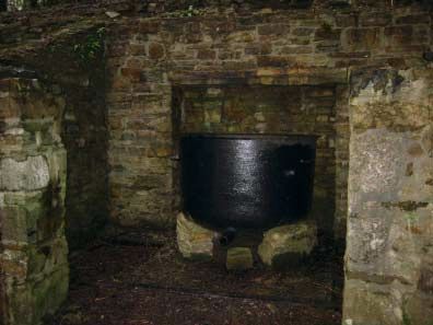
Walking through Time…..
………linking the Natural & Cultural Landscapes

Welcome to Drimarone and the Bluestack Centre!

These three routes through scenic South Donegal encompass a wide range of landscapes and
views from ‘off the beaten track’, which you can enjoy through a combination of driving, cycling
and walking.

South Donegal has a rich natural and cultural heritage. These routes have been designed to
explore the fundamental relationships between the landscape and the cultural history of the
area. The routes are colour coded and points of interest are marked along the way.

The concept of time is often difficult to grasp when dealing with earth processes. The oldest
rocks in the South Donegal region are 600 million years old and form many of the hills of the
Bluestack Mountains. If the time period of 600 million years is condensed into a single day, then
the Ice Age ended about 2 seconds to midnight and humans first appeared in Donegal about 1
second to midnight.

During those 24 hours, the granites of the Bluestack Mountains were formed at 8.00am and the
sandstones and limestones that frame Donegal Bay were deposited just before noon. The
basalt dykes that are associated with the volcanism that formed the Giants Causeway were
intruded at 9.45pm. This is one way of understanding how little time we have actually inhabited
this part of Donegal. However, in that short time span humans have adapted and utilised the
landscape to support their lifestyles.

Among the earliest examples of human activity along the routes are the megalithic tomb at Disert
and the earthen mound at the north end of Lough Mourne which are pre-Christian, providing
evidence of the complex social and agricultural organisation of early settlers. Megalithic standing
stones are common throughout the region.

Donegal Town dates back to ninth century Viking times. The Vikings established a fortress at the
mouth of the River Eske and it is possible that this gave the town and the county its name – Dun-
na-nGall, meaning Fort of the Foreigners. Planned settlement patterns were imposed in the
seventeenth and eighteenth centuries on the ancient town as evidenced by the formal market
square, the ‘Diamond’. These settlement patterns derived from the plantation of Ulster and were
important in encouraging settlers and subsequent economic development.

More recent developments such as roads and railways (now disused) utilise the natural attributes
of the area by exploiting valleys and gaps sculpted by ice along geological faults. Additionally,
natural energy is captured by the windfarms to the south of Barnesmore and at Meenaguse, and
by the small-scale hydroelectric schemes on the Lowrymore River.

The routes and stops suggested in this booklet allow the variety of the South Donegal landscape
and its cultural heritage to be appreciated.

We hope you enjoy yourself - why not come again?
Geological History of South Donegal The southern part of Donegal has had a long and
complex geological history. The oldest rocks in the area of this map are the quartzites that form
Carnaween in the west of the area. These rocks are from the Proterozoic era and are over 600
million years old. The other major rock types from this era are the Lough Mourne and Lough
Eske Formations. These were sedimentary rocks that have been subjected to heat and pressure
which has converted them to metamorphic rocks.

The Barnesmore Granite was intruded into the Proterozoic Lough Mourne and Lough Eske
Formations 400 million years ago during the Devonian period. The granite was molten when it
ascended through the earth’s crust and solidified in its present location. The Barnesmore granite
is made up of three different types of granite and forms the hills from Barnesmore in the east to
the Struell Valley in the west.

Then 325 million years ago in the Carboniferous period, sandstones, limestones and shales
were laid down under water. At this time there was a precursor to Donegal Bay which was larger
than the present day bay. It stretched from Killybegs in the west through Lough Eske in the
centre to Laghy in the east. The rivers in Carboniferous times were eroding the same hills as we
see today (although these would have been much higher and less rounded) and carrying sediment
into the bay to form the sandstones which occur around Drumkeelan and upon which the
stonemasonry industry is based.

Sometimes the Carboniferous rocks lie unconformably on top of the Proterozoic rocks and
sometimes they have been faulted against them by earth movements. One of these faults is the
Boundary Fault which trends from Killybegs to Lough Eske, and exerts a fundamental control on
the landscape in this area. The higher ground lies to the north of the fault and comprises
Proterozoic metamorphic rocks and the Devonian granite at Barnesmore. The ground is higher
because these rocks are harder and more resistant to erosion than the softer Carboniferous
rocks that lie to the south of the Boundary Fault. The fault is drawn as the change in slope at the
base of the mountains.

However, most faults in the area trend northeast-southwest and control many of the features
and landforms in the area. The Leennan Fault, which lies to the west of Carnaween, continues
southwestwards into Mayo and northeastwards into Scotland. It is part of this fault system that
created the weakness in the rocks that allowed the sea to erode the natural harbour at Killybegs.
Other faults that transect the area are the Carnaween, Belshade, Barnesmore Lough and the
Laghy Faults. One of the most visible faults is the Barnesmore Fault which is the main control on
the landscape in the Barnesmore Gap. All methods of communication and services follow the
fault through the gap (road, rail, power, telephone).

Then, some 60 million years ago during the Tertiary period, basalt dykes (long narrow linear
features) were intruded. These generally trend northwest-southeast and can seen on some
mountains as ridges or depressions, depending on how they are affected by erosion. There are
also several basalt plugs (circular, hill-size intrusions) around Donegal Town. These rocks are
the same age and type as those that formed the Giants Causeway in Co. Antrim.

One of the most significant events to have affected Donegal was the glaciation of the Great Ice
Age. This ended some 10,000 years ago, comparatively recently in geological time, and is
responsible for sculpting the landscape that we see today. Southern Donegal has well-developed
and well-preserved examples of upland and lowland glacial features.

Glaciers would have been present in the Struell, Eglish and Barnesmore areas and at times
most of the area would have been covered by an ice sheet, hundreds of metres thick. The
glaciers exploited the already existing river systems and changed the shape of the valleys from
V-shaped to U-shaped. This resulted in the development of upland features such as hanging
valleys. The ice sheet and glaciers carried the material eroded from the uplands to the lowlands
where it was deposited whenever temperatures rose and the ice melted. Features characteristic
of glacial deposition are drumlins, kettle hole lakes and kames.        Associated with the
temperature rise and melting of the ice sheets was a rise in sea level. This is seen spectacularly
in Donegal Bay where most of the islands in the bay are actually ‘drowned drumlins’.

Green 1
Viewpoint for a panorama of the Bluestacks (blue ricks). To the northwest of Banagher Hill
(peaked hill) are the Precambrian schist and Devonian granite hills of the main Bluestack range
(Croaghconnellagh, Croaghnageer, Croaghanirwore, Croaghbarnes). The lower lying ground
in the foreground is Carboniferous Ballyshannon Limestone.

Green 2
Viewpoint across to Banagher Hill. On the lower ground, above the lough shore, are strips of
willow and alder woodland, growing on Ballyshannon Limestone. Above this are coniferous
plantations and rocky fields of the Banagher Sandstones. It is possible that Lough Eske owes
its location to the juxtaposition of the 325 million year old Carboniferous rocks on the western
side and the 600 million year old Precambrian rocks on the eastern side of the lough. The
contact between the two represents a weakness which has been exploited by erosion to create
the depression in which Lough Eske formed.

Green 3
The hills visible from this location are Carboniferous sandstones and Precambrian schists.
Benson’s Hill lies on the eastern side of the lough. The rising hills around the northern end of
the lough (from east to west are) Croaghloughaderry, Altagarranduff and Brockaghy and
comprise Precambrian Lough Mourne Schists. The hills of the Barnesmore Granite lie behind
these. It is probable that Lough Eske may have been larger than it is now as the northern end
of the lough has become silted-up over the years by sediment from the Corraber River. Also
occurring along the road are examples of ‘lazy beds’ - fields with cultivated ridges still visible. It
is possible that these fields have not been used since the Famine.

On Brockaghy (badger field), to the west, a depression, several metres wide with marked straight
sides is present. This represents a Tertiary basalt dyke - the same age and rock as formed the
Giants Causeway. Gold has been discovered in small quantities in the Edergole area and there
are several quartz veins on the sides of the track which may be related to gold mineralization.
                                                  Also visible on some of the rock faces are
                                                  striations – grooves cut into the rock by the
                                                  abrasion of the ice as it passed. At the end of
                                                  the track is a small hydroelectric scheme, the
                                                  generating station is in the forest below. Above
                                                  the hydro scheme the valley of the Corraber
                                                  River is marked by a geological fault which the
                                                  river has exploited. Looking back down the
                                                  valley are views of Lough Eske and the
                                                  patchwork of fields, forestry and vegetation.
                                                  The irregular stands of rhododendrons contrast
                                                  starkly with the planned monoculture of the
                                                  managed coniferous forests.

  Edergole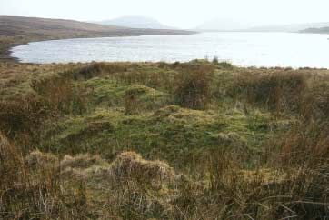
Lazy Beds                                            Corraber River

Striations                                         Quartz vein - possibly associated
                                                   with gold

North end of lough Eske

Green 4
Car park and viewpoint. The road has now crossed from the Precambrian Lough Mourne
Schists into the Carboniferous Banagher Sandstone. One mile further down the road is an
outcrop of sandy limestone, which is part of the Banagher Sandstone. The pattern of weath-
ering, displaying a ridged surface, is typical of this type of rock.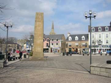
Panorama from viewpoint

Green 5
Famine Pots are relics from the failures of the potato crops in the 1840s. They were introduced
into Ireland by the Society of Friends (Quakers) and were used to make soup in communal
kitchens. The soups were made from any scraps that were available and is reported that even
nettles were used as vegetables.

Famine pot

Green 6
The trace of the Belshade Fault trends down the Eglish Valley (church) and lies at the foot of
the hills and marks the contact between the Carboniferous rocks, the Precambrian rocks and the
Barnesmore Granite. The hills on the east are Barnesmore Granite, the hills in the centre and
west are Precambrian Lough Mourne Schists. The contact between the granite and the schists
lies in the little valley between the two ridges. The rock types can be differentiated at a distance
by the steep faces that form in the granite and the sloping faces that represent the Lough Mourne
Schists. Along the ridge to the west (left) are two knobs of rock. These are small granite
outcrops, related to the Barnesmore Granite, and their distinctive knobbly shape indicates their
difference from the Lough Mourne Schists. The slope profile of the western part of the ridge
changes from steep at the top to shallower at the bottom and marks the trace of a second fault
– the Boundary Fault. Coinciding with this change in slope is a change in vegetation that is
reflecting the underlying rocks. The heather-dominated lower slopes of the western part of the
hill are Carboniferous sandstones while the grassier upper parts are Lough Mourne Schists.
Travelling down the valley, there are examples of houses abandoned during the Famine, lazy
beds and stone kilns used to burn limestone to provide fertilizer.

Panorama of northwestern side of the Eglish valley

Houses deserted during the Famine

Granite knolls. Note vegetation change on carboniferous rocks in foreground
Green 7
Meenataggart Hall was one of three community halls in the area where dances and meetings
were held on a regular basis until the 1950s. People came on foot and by bicycle from a 15-
20km radius to attend the dances on a Sunday evening. Dances started at 8.30pm and ended
at midnight. The admission charge was 6d (3 cents). However, Christmas night dances went on
until 2.30am and cost 1 shilling to attend (6 cents)

Meenataggart Hall

Green 8
View of U-shaped Struell Valley (stream). The shape of the valley was cut from a V-shaped
river valley by a glacier in the Ice Age. The erosion by the ice cut away the lower sections of the
streams on the sides of the valley and they now form ‘hanging valleys’ with waterfalls. The Grey
Mare’s Tail waterfall is an example of this. The rocks on the sides of the Struell Valley are the
Lough Mourne Schists and the Barnesmore Granite is at the end of the valley.

Struell Valley

                                                     Grey Mares Tail waterfall
Green 9
Views of Meenaguse Lough which sits in glacial deposits and together with the small lake to the
east may represent ‘kettle hole’ lakes. These lakes formed as the ice sheets retreated, leaving
behind large blocks of ice, isolated from the main ice mass, which were partially or completely
buried by sand and gravel. When the ice melted, hollows were left which now often contain
lakes. The derelict house on the north side of the road, with abundant fuschia surrounding it was
the residence of Bob Bernen during the 1960s and 70s. Bernan was an American author who
was drawn to Donegal and wrote ‘Tales from the Bluestacks’ and ‘The Hills: more tales from the
Bluestacks.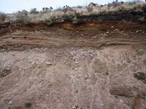
In areas adjacent to blanket bog bog myrtle is common. The blanket bog has the typical
abundance of ling heather and sphagnum moss as well as a variety of other mosses and
lichens especially Cladonia impexa, growing on the stems of the heather. Even at high elevations
looking down over Meenaguse people have planted and trees along boundaries close to houses
to provide wind breaks. Again, fuschia is a favourite plant here (it was introduced into Irish
gardens in the late 1700s from South America).
Meenaguse Lough
Green 10
The mountain on the west is Carnaween and is composed of quartzite. A major fault trends
along the lower slopes of the mountain and joins the Boundary Fault. This fault trends southeast
to Killybegs (small churches) where it caused a weakness in the rocks that the sea exploited to
form the natural harbour, which gave rise to Ireland’s major fishing port. Local legend says that
Diarmaid and Gráinne spent a night on the summit of Carnaween during their elopement and
pursuit by Fionn.
Carnaween
Green 11
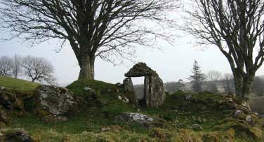
Disert means a place of solitude or hermitage and it is believed that early monks came to study
and pray here. The long history of the site is evidenced by the megalith to the east of the altar
which is believed to mark the burial site of a druid chieftain. Although adult burials ceased at
Disert around 1840, infant burials continued until the 1930s. Numerous local traditions have
built up surrounding the site ranging from ways to improve virility to methods of curing eye
disorders and backache. Clay from the site was, until recently, put into the foundations of new
houses in the belief that it would banish rats.
The area around the well and burial site at Disert presents a restricted but interesting flora.
Bluebells thrive in the area, even in intensely grazed fields, probably due to the non-application
of artificial fertilizers. Foxgloves grow where protected by stone walls and exposed tree roots.
Thistles are common and are reportedly a favourite food of donkeys. Many fields are bracken
choked in the summer months, possibly another indication of the absence of artificial fertilizers.
Near the parking area on the way to Disert a small stream has incised a deep gorge which has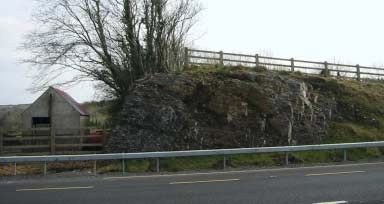
been fenced off and contains a stand of hazel trees with a local rich flora of primroses, lesser
celandine and wood anemone. Along the road cut there also dog violets, foxglove, wild
strawberry and various fern and moss varieties present.

                                                                     Altar at Disert

Megalith at Disert

Blue 1
The panorama looks north to the western part of the Blue Stacks. The most westerly peak is
Binbane, the long ridge to the east is Cloghmeen Hill which passes into the more rugged peak
of Carnaween. The windfarm is at Meenaguse and the mountain to the east of this is Binnasruell.

All the low hills in the foreground are underlain by the harder 300 million year old Carboniferous
age Drumkeelan Sandstone and have had ice-deposited drumlins superimposed. The low ground
before the mountains is also underlain by 300 million year old shales, limestones and sandstones.
However, the rocks that form the mountains are 600 million years old and are made up of quartzites
– sandstones that have been heated and compressed by the earths forces and have become
even harder and more resistant to erosion. A major geological fault has brought older rocks of
the mountains into contact with the younger rocks of the foreground. The trace of this fault runs
along the break in slope of the mountains. The shapes of all the hills are controlled by the rocks.
For example, Binbane has a gentle slope to the west which becomes steeper towards the summit.
This is due to different rocks, one of which is more resistant to erosion than the other. The
elevation of the ground also controls land usage; e.g. the lower and drumlin-covered ground has
subsistence farms and irregular settlements. The area has also more modern land uses such as
windfarms and commercial forestry.
Blue 2
Donegal Town is a 17th century planned plantation town. One of the main results of the plantation
was that rural parts of Ireland, controlled by Gaelic Chiefs, were urbanized through planned
towns, which encouraged settlers. Typically a planned town will have; a market square (the
Diamond), a castle, a Protestant church occupying the dominant position in the town and wide
and regular streets. In the Diamond is the monument to the Four Masters (made of Drumkeelan
Sandstone).
Four Masters
Memorial, Donegal
Town
The Four Masters compiled the most extensive of all the compilations of the ancient annals of
Ireland. The principal compiler of the Annals was Michael O’Clery, a native of Donegal and a
trained antiquary and poet, who joined the Franciscan Order. O’Clery went to Belgium, but was
sent back to Ireland to collect the lives of Irish saints and he retired to the secluded convent of
Donegal while engaged upon this work (1632-1636). The ‘Annals of the Four Masters’ are so-
called because the compilers were learned masters in antiquarian lore.
They are written in an archaic language, and document the reigns, deaths, genealogies, etc.,
not only of the high-kings of Ireland, but also of the provincial kings, chiefs, and heads of
distinguished families, men of science, historians, poets, etc. They record the demise and
succession of saints, abbots, bishops, and ecclesiastical dignitaries. They tell of the foundation
and occasionally the overthrow of countless churches, castles, abbeys, convents, and religious
institutions. They give details of battles, murders, tribal wars, wars with the foreigners, battles
with Norsemen, Normans, and English, and political changes. There is no event in the whole of
Irish history from the birth of Christ down to the beginning of the seventeenth century that the
first enquiry of the student should be: “What do the Four Masters say of this?”
Blue 3
St Patricks Church or The Memorial Church of the Four Masters was dedicated on 17th March
1935. All the material used in the building is of Irish origin – the walls are Barnesmore Granite,
the door and window surrounds are of Drumkeelan Sandstone and the roof slates are from St
Johnston. The mortar is lime based and was used extensively in natural stone buildings.St Patrick’s Church,
Donegal Town
Ballyshannon Limestone
Blue 4.
The rocks on the southeastern side of the road are part of the Ballyshannon Limestone. This
is a mid grey limestone, with vertical calcite veins and fossil fragments. Sometimes the fragments
are easily visible and there are ring-like pieces (about the size of a 1• coin) which formed the
stems of crinoids, commonly known as sea lilies (related to starfish and sea urchins). They
were most abundant 300 million years ago. In between the limestone beds are thin black shales.
If you want to look at these rocks, take care, as the road is often very busy.
Plant Fossil
Blue 5
The rocks on the
southeastern side of road are
sandstones, which lie below
the limestones at the previous
stop and are therefore older
than them. This is because
younger rocks form on top of
older rocks. The sandstone
beds are clearly visible and
also have thin shales
between them. These sandstones represent an ancient river delta whose rivers drained theHighlands to the north into the precursor of Donegal Bay. Some parts of the outcrop have plant
fossils. If you want to look at these rocks, take care, as the road is often very busy.
Map of Donegal and
placenames
Blue 6
This location is accessed by
a small car park on the
northwestern side of the
road. The surround of the
plaque marking the
construction of the
Barnesmore Gap road is of
Ballyshannon Limestone.
However, the black rock
which carries the inscription
is called gabbro and is
probably from South Africa
and may be 2000 million
years old – much older than
any rocks in Donegal. The
monolith bearing the large
map of Donegal is carved in Drumkeelan Sandstone. Note that in the text of John O’Donovan
that Barnesmore Gap is referred to as the ‘Gap of Danger’. The Four Masters record that
Barnesmore was a ‘refuge for robbers and rogues before Red Hugh banished them.’ Prior to the
railway in 1882 this was the only way to travel through the Gap which was well named as the
‘Gap of Danger’ as highwaymen and robbers plundered the stagecoaches on the road. If caught,
the villains risked being hung at a gallows near the old Derg Bridge Halt, to the south of Lough
Mourne. O’Donovan was the person charged with the responsibility of recording all the townlands
of Donegal for the first Ordnance Survey of Ireland. He used local knowledge and also the
Annals of the Four Masters to set down the place names as we know them today. On the north-
facing side of the monument the place names of Donegal are inscribed. Before the path of the
present road, the old road through the Barnesmore Gap was along the slopes of Croaghconnellagh
and traces of it can still be seen.
Weir in Lowrymore River
Bedrock folds in
river
The path beside
the monolith leads
to a small
hydroelectric
station. A weir
has been
constructed in Lowrymore River to allow abstraction of water through a large pipe (under the
wooden walkway). This flow drives the turbines in the plant house and then passes back into the
river. In the river bank opposite the plant house are examples of folding in the 600 million year
old Lough Eske Psammites.Barnesmore Gap
Straight ahead is the classic U-shaped profile
of a glaciated valley. On the southeastern side
is Barnesmore and on the northwestern side
is Croaghconnellagh. The Barnesmore Fault
that caused the weakness in the granites and
quartzites of the Barnesmore area allowed this
to be exploited by an ancient river which eroded
the original valley. Then, during the Ice Age
(10,000 years ago) a glacier sculpted the
present-day shape of the Barnesmore Gap
from the old river valley. The Gap forms the
most direct route between Donegal Town and
Ballybofey and also provides access for road, electricity, telephone and formerly rail.
Meander in Lowrymory River
Blue 7
The car park at Biddy O’Barnes pub marks
the position where the 600 million year old
Lough Mourne Grits are in contact with the
Barnesmore Granite – the stone that was used
to build St Patricks church. The granite rose
form deep in the earth to its present position
400 million years ago. Crossing the river to the south a track climbs onto the old railway line. It
is a 4km walk to the next bridge crossing over the Lowrymore River.
Straightening of Lowrymore River
The walk follows part of the old West
Donegal Railway which dates from
1882. There were two halts on the line
in this area – the Derg Bridge Halt was
north of the Castlederg road, to the south
of Lough Mourne and the Barnesmore
Halt, lay some 8km to the south of Derg
Bridge Halt. There is no trace of the
platform or siding at the Derg Bridge Halt remaining. The siding was constructed in 1946 to
transport locally quarried sand and gravel to Ballyshannon to construct the Erne hydroelectric
scheme at Assaroe. Folklore has it that the railway was responsible for reintroducing the beech
tree to Donegal and the course of the railway line can be traced by picking out the beeches
which were planted as lineside hedging. Retaining walls to support the track still remain on parts
of the line through the Gap.
The walls and stiles are made from Barnesmore granite. About 100m along the track, in a small
partially overgrown cutting the contact between the Lough Mourne Grits and the Barnesmore
Granite is present. Other features visible from the former rail line include river meanders, areas
of the river which have been straightened and armoured to prevent erosion, a series of deeplyWall with stile in Barnesmore Granite
incised streams which follow joints in the
granite and large bounders on the lower
slopes which have broken off through freeze-
thaw action and rolled down the hillside.
Ice-deposited boulder clay and
water-lain sands
Blue 8
Walk up track to sand and gravel
quarrying operation. Most of the
moraine is composed of till with
Lough Mourne Grits and also
some basalt. The basalt probably
comes from the numerous dykes
that traverse Donegal. Some of
the sections through the glacial
material indicate that the ice
advanced and retreated several
times as ice-deposited unsorted till
is overlain by water-deposited
sands and gravels. Sandmartins
have made their nests in the sandy
layers of the glacial gravels.
Area of Bog burst
In this area peat bog is well developed
in parts. In the 1960s there was a ‘bog
burst’ which causd tons of bog
material to flow into the Lowrymore
River. Bog bursts tend to happen in
winter perhaps due to increased
amounts of spring water entering the
bog and causing the core of the bog
to liquefy and flow.
Blue 9
Inside the gate is the old railway line which is visible alongside the lough– cross this and walk
along path parallel to conifer plantation for 100m and turn left towards trees for 30m. At this
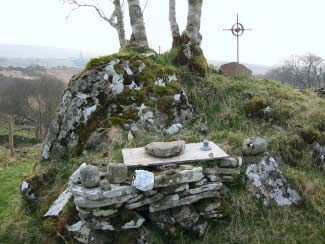
location is an example of a mound which may date from pre-Christian times. There is a thin
cover of peat in this area as evidenced by the small quarry on the eastern side of the lough.
Lough Mourne is elongated northeast-southwest along the Barnesmore Fault. It is probable that
the fault has caused a weakness in the underlying rocks that has been eroded and filled with
water. Therefore the fault may be the reason for the presence of the lough and the formation of
Gap to the south.Mound at
Lough Mourne
Drumlin Landscape
Red 1
On either side of the road at this location are good examples of drumlins (small hills) which are
formed from boulder clay - an unlayered deposit of rocks, pebbles, gravel, sand and clay deposited
at the base of an ice sheet. Drumlins are particularly well developed in Ireland and form a
‘basket of eggs’ belt that stretches from Mayo in the west to Strangford Lough in the east. In
south Donegal, the drumlins are orientated northeast-southwest and mark the direction of the
movement of the ice. Drumlins have a blunter, steeper end and a tapered end; the blunt end
indicates the direction from where the ice came – in the case of south Donegal, from the northeast.
This part of the journey presents a varied and natural flora. Hazel, alder, birch and willow trees
line the road. Dry banks on either side of the road host a rich flora of primrose, lesser celandine,
spurge, wood anemone, bluebell and foxglove with occasional patches of winter flowering
petasites fragrans. Honeysuckle vines hang from the trees on the overgrown hedgerows. Anabundance of moss on stones and tree barks indicates the overall damp nature of the area,
partly due to the shelter offered from the winds by the surrounding drumlins.
Red 2
View over Donegal Bay. Drumlin landscape in the foreground with the ‘Green Islands’ in the bay
joined by a tombolo. The sandspit on the far side of the bay is at Murvagh. A sandspit is
formed when material is deposited with one end attached to the land and the other projecting
into the open sea, typically across the mouth of a river estuary – in this case the River Eske. A
tombolo is formed where a spit links an island to the mainland. The hills in the distance are in
Co. Sligo and are composed of Carboniferous limestone.
Donegal Bay
Red 3
On the southern side of the road are a series of quarries in Drumkeelan Sandstone (narrow
ridge). The sandstone is flat lying and easy to quarry. The flaggy nature of the sandstone is
good for facing buildings and construction. Drumkeelan Sandstone used to be mined from
underground and provided building stone for the National Museum, the National Library, the
Dáil, Sligo Town Hall and Assaroe Abbey in Ballyshannon. The Abbey was constructed in 1179
and Drumkeelan Sandstone was probably shipped from Mountcharles. A medieval miners lamp,
carved from stone was also found underground.
Of note is the little amount of glacial cover - even
in an area where most hills are glacially-deposited
drumlins, little or no till was deposited on the
Drumkeelan Sandstone ridge.
Drumkeelan Sandstone Quarry
Red 4
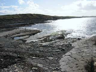
The outcrops on the shore are of Ballyshannon
Limestone. The limestone dips at low angles to
the southeast and contains abundant fossils.
These include solitary and colonial corals,
bivalves and crinoids. Corals are simple
animals that secrete skeletons made of calcium carbonate. Corals are among the simplest
multicellular animals and are characterized by their radial symmetry. They are close relatives of
sea anemones and jellyfish and are the main reef builders in modern oceans. Corals can be
either colonial or solitary. The views to the northwest are of Crownarad and Slieve League -
both mountains are made of quartzite - a rock very resistant to erosion. Many hedgerows in the
area provide a good environment for montbretia to spread from old houses. Good examples of
great horse tail can also occasionally be seen along the roadside.Ballyshannon Limestone Fossil debris of crinoids Solitary coral (Caninia) fossil Bivalve fossil
Red 5
This location is a coral beach. The beach formed because of two parallel faults in the rocks at
each end of the causeway. These faults created weaknesses in the rocks which were eroded by
the sea and formed the inlet. The beach ‘sand’ is made up of very fine coral debris. At the last
location the limestone contained large corals which flourished in warm water 325 million years
old and on this beach there are small fragments of modern cold water corals. On the far side of
the beach are examples of folds in the rocks caused by earth movements millions of years ago.

Coral beach

                                                                         Folding in
                                                                         Carboniferous rocks

                                                                          Red 6
                                                                          Walk along the beach to
                                                                          the south to examine the
                                                                          sea-washed section of
                                                                          the drumlin that forms
                                                                          Ball Hill. There are two
                                                                          glacial boulder clays
                                                                          present at this location,
                                                                          a mid grey lower boulder
                                                                          clay and a dark grey
upper boulder clay. Most of the rocks in the boulder clays are limestone. However, there are
some pieces from the Barnesmore Granite which have been carried 16km from the northeast
by the ice. Many of the boulders on the upper reaches of the beach have been washed out from
the boulder clay. The ‘Green Islands’ are the remnants of two drumlins that lie to the south of
Ball Hill. These islands have been joined together in recent times by a tombolo. The evidence
for this is the well-layered sandy and shelly sediments that join the older ice deposited drumlins.
At the southern end of the Green Islands, the view across to Murvagh raises the question as to
why the southern shore of the bay is sandy and the northern shore boulder strewn? This is due
to the development of Murvagh as a sandspit where sea currents trend northwards and move
sand to form a spit. The shape of the spit reflects the influences of both the sea and the channel
of the River Eske (fish river).
View of eroded drumlin. Ball Hill
Upper and lower boulder clay at Ball Hill
Cobble of Barnesmore Granite
in boulder clay
Tombolo joining Green Islands
Red 7
The house at St Ernan’s was built on an island in 1824-26 by John Hamilton (a nephew of the
Duke of Wellington) and was only passable by walking at low tide or by boat at high tide. At half
tide neither was possible. Hamilton was a good landlord and undertook many schemes to provide
employment for his tenants, including a mill, a school and road construction. However, he had a
personal desire to link the island to the mainland. Hamilton was advised that this would not
succeed due to the strong sea current, but after several failures the causeway was constructed.
His tenants did most of the construction free-of-charge, which is commemorated on the plaque
part way across the causeway. St Ernan’s is now a country house hotel. Looking west provides
the contrast between the man-made causeway at St Ernan’s and the sea-built causeway (tombolo)
at the Green Islands.Causeway to St Ernan’s
Red 8
Murvagh is a sandspit that has formed due to the swash and backwash of waves which move
sand about a beach - longshore drift. At Murvagh, the zigzag movement of the sand caused by
the swash and backwash has not happened and deposition has taken place at the northern end
of the spit. The channel between Murvagh and the Green Islands is called the ‘Hassans’ and is
kept open by the River Eske.
Please note: The maps included here are much reduced and should be used for loca-
tion of the routes only. They are extracts from the Ordnance Survey Discovery Series;
Sheets 10 & 11 which are widely available in bookshops etc. and are ideal for the level
of detail required here.
Alternatively the Bluestack Centre can supply original copies of the guide which includes
maps. (see front for details)
Produced by:
CSA Group, 7 Dundrum Business Park, Windy Arbour, Dublin 14 Ireland
Telephone: + 353-1-296 4667 Fax: + 353-1-296 4676
www.csa.ie
Ordnance Survey of Ireland Licence No: 0000702 © Government of Ireland9
1
9
8
10 8
1
11 6
3
7
4
2
7
1
5
1 6
1
1
1
5
1
4
1
1
3
1
2
1 Donegal
Town
2
1
3
11
1
1
3
1
2
1 Donegal
Town
2
1
3
1
6
1
7
1
4
1
8
1
5
1 0 1 2 3km
Scale: 1: 50,000You can also read