Transportation Impact Assessment - Proposed Warehouse 241 Sturbridge Road (Route 20) Charlton, Massachusetts - Town of Charlton
←
→
Page content transcription
If your browser does not render page correctly, please read the page content below
Transportation Impact Assessment
                        Proposed Warehouse
               241 Sturbridge Road (Route 20)
                      Charlton, Massachusetts

                                             Prepared for:

                        Charlton Developer, LLC
                         Boston, Massachusetts

                                               March 2021

Prepared by:

                           35 New England Business Center Drive
                                                      Suite 140
                                             Andover, MA 01810
35 New England Business Center Drive
                                                                                                        Suite 140
                                                                                               Andover, MA 01810

Dear Reviewer:

This letter shall certify that this Transportation Impact Assessment has been prepared under my direct
supervision and responsible charge. I am a Registered Professional Engineer (P.E.) in the Commonwealth
of Massachusetts (Massachusetts P.E. No. 38871, Civil) and hold Certification as a Professional Traffic
Operations Engineer (PTOE) from the Transportation Professional Certification Board, Inc. (TPCB), an
independent affiliate of the Institute of Transportation Engineers (ITE) (PTOE Certificate No. 993). I am
also a Fellow of the Institute of Transportation Engineers (FITE).

Sincerely,

VANASSE & ASSOCIATES, INC.

Jeffrey S. Dirk, P.E., PTOE, FITE
Managing Partner

G:\8384 Charlton, MA\Town Filing\Reports\Charlton Warehouse TIA 03_21.docx
CONTENTS
EXECUTIVE SUMMARY .............................................................................................................. 1
INTRODUCTION ............................................................................................................................ 8
Project Description .............................................................................................................. 8
Study Methodology ............................................................................................................. 9
EXISTING CONDITIONS ............................................................................................................ 10
Roadway ............................................................................................................................ 10
Intersections....................................................................................................................... 11
Existing Traffic Volumes .................................................................................................. 12
Spot Speed Measurements................................................................................................. 13
Pedestrian and Bicycle Facilities ....................................................................................... 14
Public Transportation ........................................................................................................ 15
Motor Vehicle Crash Data ................................................................................................. 15
FUTURE CONDITIONS ............................................................................................................... 18
Future Traffic Growth ....................................................................................................... 18
Project-Generated Traffic .................................................................................................. 20
Trip Distribution and Assignment ..................................................................................... 21
Future Traffic Volumes - Build Condition ........................................................................ 21
TRAFFIC OPERATIONS ANALYSIS ......................................................................................... 23
Methodology ..................................................................................................................... 23
Analysis Results ................................................................................................................ 25
G:\8384 Charlton, MA\Town Filing\Reports\Charlton Warehouse TIA 03_21.docxCONTENTS (Continued)
TRAFFIC SIGNAL WARRANTS ANALYSIS ............................................................................ 30
Methodology ..................................................................................................................... 30
Analysis Results ................................................................................................................ 31
PARKING DEMAND ANALYSIS ............................................................................................... 32
SIGHT DISTANCE EVALUATION ............................................................................................. 34
CONCLUSIONS AND RECOMMENDATIONS ......................................................................... 36
Conclusions ....................................................................................................................... 36
Recommendations ............................................................................................................. 37
G:\8384 Charlton, MA\Town Filing\Reports\Charlton Warehouse TIA 03_21.docxFIGURES
No. Title
1 Site Location Map
2 Existing Intersection Lane Use, Travel Lane Width and Pedestrian Facilities
3 2019 Existing Peak-Hour Traffic Volumes
4 2027 No-Build Peak-Hour Traffic Volumes
5 Trip Distribution Map
6 Project-Generated Peak-Hour Traffic Volumes
7 2027 Build Peak-Hour Traffic Volumes
8 Conceptual Improvement Plan – Sturbridge Road (Route 20) at the Site Driveway
9 2027 Build Weekday Morning Peak-Hour, Route 20 Eastbound at Proposed Site,
Driveway, Stopping Sight Distance Plan
10 2027 Build Weekday Evening Peak-Hour, Route 20 Eastbound at Proposed Site,
Driveway, Stopping Sight Distance Plan
G:\8384 Charlton, MA\Town Filing\Reports\Charlton Warehouse TIA 03_21.docxTABLES No. Title 1 Study Area Intersection Description 2 2019 Existing Traffic Volumes 3 Vehicle Travel Speed Measurements 4 Motor Vehicle Crash Data Summary 5 Trip-Generation Summary 6 Peak-Hour Traffic Volume Increases 7 Level-of-Service Criteria for Signalized Intersections 8 Signalized Intersection Level-of-Service and Vehicle Queue Summary 9 Traffic Signal Warrants 10 Traffic Signal Warrant Analysis – Route 20 at the Project Site Roadway 11 Weekday Peak Parking Demand Ratios 12 Sight Distance Measurements G:\8384 Charlton, MA\Town Filing\Reports\Charlton Warehouse TIA 03_21.docx
EXECUTIVE SUMMARY

Vanasse & Associates, Inc. (VAI) has conducted a Transportation Impact Assessment (TIA) in
order to assess the potential impacts on the transportation infrastructure associated with the
proposed construction of a warehouse building to be located at 241 Sturbridge Road (Route 20)
and west of Mayberry Lane in Charlton, Massachusetts (hereafter referred to as the “Project”).
Access to the Project site will be provided by way of a new driveway that will intersect the south
side of Route 20 approximately 1,200 feet west of Mayberry Lane and slightly off-set to the west
of the driveway to the JRD Technology Center (242 Sturbridge Road). The Project will require the
issuance of a State Highway Access Permit from the Massachusetts Department of Transportation
(MassDOT) for access to Route 20, a State Highway under the jurisdiction of MassDOT.

This assessment was prepared in consultation with the MassDOT and the Towns of Charlton and
Sturbridge; was performed in accordance with MassDOT’s Transportation Impact Assessment
(TIA) Guidelines; and was conducted pursuant to the standards of the Traffic Engineering and
Transportation Planning professions for the preparation of such reports. Based on this assessment,
we have concluded the following with respect to the Project:

      1. Using trip-generation statistics published by the Institute of Transportation Engineers
         (ITE) 1, 1,942 vehicle trips on an average weekday (two-way volume over the operational
         day of the Project), with 169 vehicle trips expected during the weekday morning and peak
         hour and 172 vehicle trips expected during the weekday evening peak hour;

      2. The Project will not have a significant impact (increase) on motorist delays or vehicle
         queuing over Existing or anticipated future conditions without the Project (No-Build
         conditions), with all movements at the study intersections shown to operate at a
         level-of-service (LOS) D or better under all analysis conditions, where an LOS of “D” or
         better is defined as “acceptable” operating conditions;

      3. With the installation of a traffic control signal at the Project site driveway intersection with
         Route 20 and the accompanying construction of left and right-turn lanes on Route 20, all
         movements at the intersection were shown to operate at LOS C or better during the peak
         hours;

1
 Trip Generation, 10th Edition; Institute of Transportation Engineers; Washington, DC; 2017.

G:\8384 Charlton, MA\Town Filing\Reports\Charlton Warehouse TIA 03_21.docx   1
4. The Route 20/Route 31 and Route 20/Route 169 intersections were found to have motor
vehicle crash rates that were above the MassDOT average crash rates for a signalized
intersection, and the Route 20/Route 169 intersection is included on MassDOT’s Highway
Safety Improvement Program (HSIP) listing as high crash cluster locations for 2014-2016.
A Road Safety Audit (RSA) was conducted at both intersections in 2019 by
Toole Design Group as part of the Tree House Brewing brewery and retail store project
(EEA No. 15900) that resulted in a series of recommendations for safety enhancements
that are being implemented by the Tree House Brewing; and
5. Lines of sight to and from the Project site driveway intersection with Route 20 exceed the
recommended minimum distances for the intersection to function in a safe and efficient
manner based on the measured speed of traffic along Route 20 approaching the roadway
and with consideration of the need for trucks to cross additional travel lanes when exiting
the driveway.
In consideration of the above, we have concluded that the Project can be accommodated within the
confines of the existing transportation infrastructure in a safe and efficient manner with
implementation of the recommendations that follow.
RECOMMENDATIONS
A detailed transportation improvement program has been developed that is designed to provide safe
and efficient access to the Project site and address any deficiencies identified at off-site locations
evaluated in conjunction with this study. The improvements that have been recommended as a part
of this evaluation, where applicable, will be completed in conjunction with the Project subject to
receipt of all necessary rights, permits, and approvals.
Project Access
Access to the Project site will be provided by way of a new driveway that will intersect the south
side of Route 20 approximately 1,200 feet west of Mayberry Lane and slightly off-set to the west
of the driveway to the JRD Technology Center (242 Sturbridge Road). The Project will incorporate
the following measures with respect to the design and operation of the Project site access and
internal circulation:
The Project site driveway and internal circulating drives will be a minimum of 24-feet in
width or as required to accommodate the turning and maneuvering requirements of delivery
trucks and the largest anticipated responding emergency vehicle.
A review of the warrants specified in the Manual on Uniform Traffic Control Devices
(MUTCD) 2 for the installation of a traffic control signal indicates that the installation of
a traffic control signal at the Project site driveway intersection with Route 20 is
warranted under 2027 Build conditions. As such, a traffic control signal will be installed
at the Project site driveway intersection that will serve both the Project and the east
driveway to the JRD Technology Center, along with the following intersection geometry:
− Route 20 Eastbound: (1) left-turn lane, (2) through travel lanes, (1) right-turn lane
− Route 20 Westbound: (1) left-turn lane and (2) through travel lanes
2
Manual on Uniform Traffic Control Devices (MUTCD); Federal Highway Administration; Washington, D.C.; 2009.
G:\8384 Charlton, MA\Town Filing\Reports\Charlton Warehouse TIA 03_21.docx 2− Project Site Driveway: One (1) entering travel lane and two (2) exiting travel lanes
separated by a double-yellow centerline
With the installation of a traffic control signal at the intersection and the associated
geometric improvements, all movements at the signalized intersection are predicted to
operate at LOS C or better during the peak hours.
All signs and pavement markings to be installed within the Project shall conform to the
applicable standards of the MUTCD. 3
Marked crosswalks and Americans with Disabilities Act (ADA) compliant wheelchair
ramps should be provided at pedestrian crossings within the Project site.
Signs and landscaping located within intersection sight triangle areas should be designed
and maintained so as not to restrict lines of sight.
Snow windrows within sight triangle areas shall be promptly removed where such
accumulations would impede sight lines.
Electric vehicle (EV) charging stations will be installed in the employee parking lot with
infrastructure installed to expand the number of EV charging stations as demand warrants,
including for trucks.
Preferential parking will be provided in the employee parking lot for car/vanpools.
Off-Site
Route 20 at Picker Road and Fiske Hill Road
The unsignalized intersection of Route 20 at Picker Road and Fiske Hill Road was not included as
a part of the formal study area that was assessed for the Project; however, at the request of the
Town of Sturbridge, a qualitative assessment of Project-related impacts at this intersection was
undertaken. The Project is not expected to add additional traffic to Picker Road, which is a dead-
end roadway that intersects the north side of Route 20 west of Route 49, or to have a material
increase in traffic volumes along Fiske Hill Road, which is located opposite Picker Road and from
which left-turns are prohibited to Route 20 westbound. That being said, the Project will add traffic
to Route 20 that will travel through the intersection and result in additional delay to vehicles exiting
from Picker Road and Fiske Hill Road, both of which have been identified as experiencing delays
with residual vehicle queuing under existing conditions.
A review of the MassDOT statewide High Crash Location List indicated that the Route 20/
Fiske Hill Road/Picker Road intersection is included on MassDOT’s Highway Safety Improvement
Program (HSIP) listing as high crash cluster location for 2015-2017. As a result of this designation,
a Road Safety Audit (RSA) was conducted in 2015 by McMahon Associates, Inc. on behalf of the
MassDOT that included the Route 20/Fiske Hill Road/Picker Road intersection and the Route 20
corridor between the Xtramart Plaza driveway and Route 49. 4 The RSA identified a series of
measures to improve safety at the Route 20/Fiske Hill Road/Picker Road intersection that included
the following: evaluate the feasibility of providing a left-turn lane on the Route 20 eastbound
approach; restrict through movements between Fiske Hill Road and Picker Road; and improve the
3
Ibid.
4Road Safety Audit, Route 20 (Charlton Road) Corridor; Town of Sturbridge; McMahon Associates, Inc.; January 2015.
G:\8384 Charlton, MA\Town Filing\Reports\Charlton Warehouse TIA 03_21.docx 3intersection geometry to increase sight lines on all approaches. The Town is working with
MassDOT to advance the improvements at this intersection that were recommended as a part of the
RSA.
In an effort to assist the Town of Sturbridge in the advancement of the improvements at this
intersection that are desirable independent of the Project, the Project proponent will prepare a
Functional Design Report (FDR) and accompanying conceptual designs for improvements to the
intersection. The FDR and concept plans will be provided to the Town of Sturbridge prior to the
issuance of a Certificate of Occupancy for the Project and will include a preliminary cost estimate
and supporting materials.
Transportation Demand Management
Regularly scheduled public transportation services are not currently available to the Project site or
along Route 20 west of Route 169; the Worcester Regional Transit Authority (WRTA) does provide
fixed-route bus services along Route 20 to the east of Route 169. In an effort to encourage the use
of alternative modes of transportation to single-occupant vehicles, the following Transportation
Demand Management (TDM) measures will be implemented as a part of the Project:
A transportation coordinator will be assigned for the Project to coordinate the TDM
program;
Information regarding commuting options will be posted in a central location and/or
otherwise made available to employees of the project;
The transportation coordinator will facilitate a rideshare matching program for employees
to encourage carpooling;
A “welcome packet” will be provided to employees detailing available commuter options
and will include the contact information for the transportation coordinator and information
to enroll in the employee rideshare program;
An Emergency Ride Home program for employees that car/vanpool or that arrive to the
Project site by means other than in a single-occupant (SOV) will be provided at no cost to
employees and managed by the transportation coordinator.
Specific amenities will be provided to discourage off-site trips, including providing a
break-room equipped with a microwave and refrigerator; offering direct deposit of
paychecks; coordinating with a dry-cleaning service for on-site pick-up and delivery;
allowing telecommuting or flexible work schedules; and other such measures to reduce
overall traffic volumes and travel during peak-traffic-volume periods;
Pedestrian accommodations will be incorporated within the Project site to link the
employee parking area to the warehouse building; and
Secure bicycle parking will be provided at an appropriate location within the Project site.
G:\8384 Charlton, MA\Town Filing\Reports\Charlton Warehouse TIA 03_21.docx 4Traffic and Construction Management Plan
The Project proponent will implement a Traffic and Construction Management Plan (TCMP) in
coordination with MassDOT and the Town of Charlton in order to facilitate safe and efficient access
to the Project site during construction activities. Summarized below are several measures which
the Project proponent and the general contractor will undertake during the construction phase of
the Project.
The Project proponent will coordinate with MassDOT and the Town regarding all
transportation-related construction impacts of the Project.
Prior to the implementation of any planned construction activities within the Route 20 State
Highway Layout, including for temporary access to the Project site for construction
activities, the contractor will submit to MassDOT for review and approval a Temporary
Traffic Control Plan (TTCP).
The general contractor will encourage employees to car/vanpool to the Project site in order
to reduce construction-related traffic associated with the Project.
The general contractor will offer an Emergency Ride Home program to employees that
car/vanpool to the Project site.
Designated truck routes will be established to govern how trucks access the Project site.
The goal of this commitment is to have construction trucks use only the regional highway
system (Route 20, Route 49, Interstate 84 (I-84)) and to avoid using residential streets to
the extent practical. Construction contracts for the Project will include notification of this
provision and contain explicit language prohibiting travel over residential streets.
Secure fencing and sidewalk staging protection will be provided in areas affected by the
construction to protect nearby pedestrian and vehicular traffic. Gate entrances into the
construction area(s) will be approved by MassDOT as a part of the TTCP.
Secure on-site storage will be provided for tools and equipment in an effort to minimize
construction-related vehicle trips to the site.
Full or partial street closures will be avoided to the extent possible. Should a partial street
closure be necessary in order to off-load construction materials and/or complete
construction-related activities, the closure will be limited to off-peak periods as defined by
MassDOT so as to minimize the impact of vehicular and pedestrian flow. Police details
will be utilized as required by the MassDOT and the Town.
Construction worker parking will be expressly prohibited along Route 20. Construction
contracts for the Project will include notification of this prohibition.
G:\8384 Charlton, MA\Town Filing\Reports\Charlton Warehouse TIA 03_21.docx 5Traffic Monitoring Program
The Project proponent will conduct a post-development traffic monitoring and employee survey
program in order to evaluate the success and to refine the elements of the TDM program, and to
validate the trip projections and parking demands for the Project. The monitoring program will
include:
i) Obtaining traffic-volume information over a continuous seven-day, weeklong period
at the driveway serving the Project site;
ii) Performing manual turning movement and vehicle classification counts at the Project
site driveway intersection with Route 20 during the weekday morning (7:00 to
9:00 AM) and weekday evening (3:00 to 6:00 PM) peak periods; and
iii) Evaluating motor vehicle crash data at the Project site driveway intersection with
Route 20.
The monitoring program will commence six (6) months after issuance of the Certificate of
Occupancy for the Project and will continue on an annual basis thereafter for a period not to exceed
5-years after completion of the Project. The results of the monitoring program will be summarized
in a report to be provided to the Town of Charlton and MassDOT within 2-months after the
completion of the data collection effort. The report will document: i) traffic volumes associated
with the Project; ii) motorist delays, vehicle queuing, crash severity and calculated crash rates at
the Project site driveway intersection with Route 20; and iii) the elements of the TDM program that
have been implemented and use of alternative modes of transportation to single-occupant vehicles.
If any of the following conditions are documented as a part of the monitoring program: i) the
measured traffic volumes exceed the observed traffic volumes that are presented herein by more
than 10 percent on a regular and sustained basis during the monitoring period; ii) there is a material
increase in the number of motor vehicle crashes occurring at or in immediate vicinity of the Project
site driveway intersection that are attributable to the Project; or iii) operations along Route 20 at
the Project site driveway deteriorate to the extent that there is an impact to operations along
Route 20 as evidenced by extended vehicle queuing; the Project proponent will identify and
undertake corrective measures in conjunction with the appropriate parties and subject to receipt of
all necessary rights permits and approvals. These measures may include without limitation:
− Sign and pavement marking installation
− Traffic signal timing modifications at the Route 20/Project site drive intersection and at the
signalized study area intersections
− Geometric improvements along Route 20 at and approaching the Project site driveway to
the extent that said improvements can be completed within the public right-of-way or on
land controlled by the Project proponent
− On-site operations and management strategies to include: expansion of the elements of the
TDM program to include financial incentives for employees to car/vanpool; scheduling
employee and truck operations to minimize impacts during peak-traffic-volume periods
along Route 20; evaluating implementation of an employee shuttle program; and other such
measures that are designed to reduce the overall volume of traffic generated by the Project.
G:\8384 Charlton, MA\Town Filing\Reports\Charlton Warehouse TIA 03_21.docx 6The identified corrective measures, if any, will be documented in the transportation monitoring program report, and will include the appropriate parties responsible for implementation, required approvals, and the timeline for implementation. The status of implementation of the identified improvement measure will be documented in the subsequent monitoring report. With implementation of the aforementioned recommendations, safe and efficient access will be provided to the Project site and the Project can be accommodated within the confines of the existing and improved transportation system. G:\8384 Charlton, MA\Town Filing\Reports\Charlton Warehouse TIA 03_21.docx 7
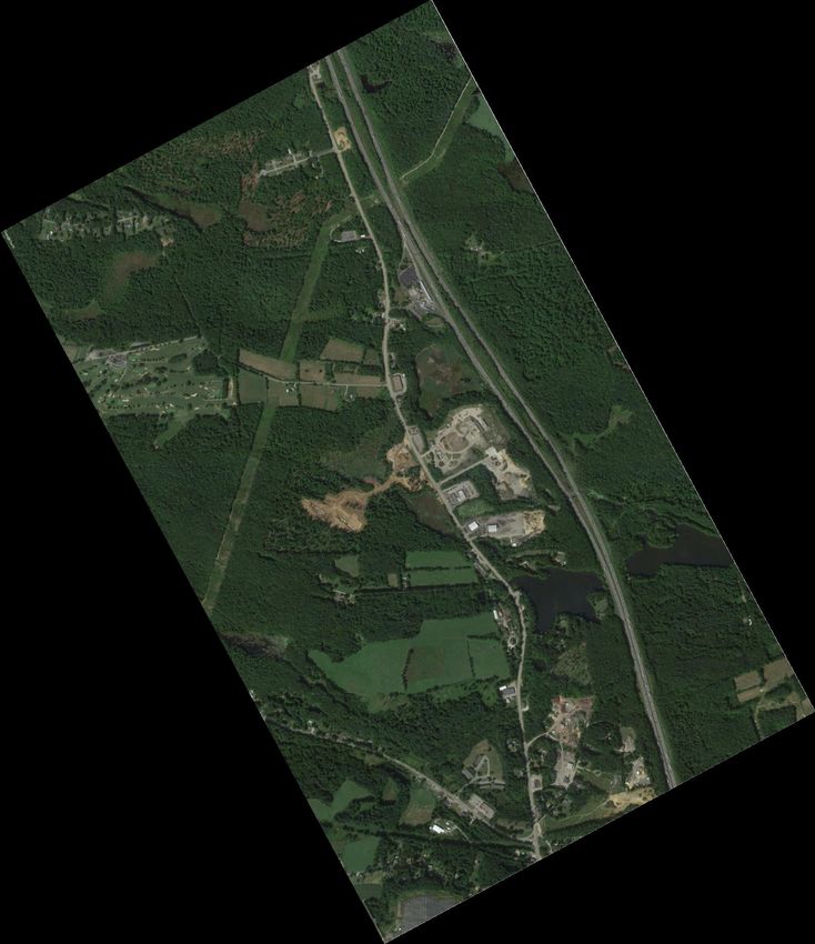
INTRODUCTION

Vanasse & Associates, Inc. (VAI) has conducted a Transportation Impact Assessment (TIA) in
order to determine the potential impacts on the transportation infrastructure associated with the
proposed construction of a warehouse building to be located at 241 Sturbridge Road (Route 20)
and west of Mayberry Lane in Charlton, Massachusetts (hereafter referred to as the “Project”). This
study evaluates the following specific areas as they relate to the Project: i) access requirements;
ii) potential off-site improvements; and iii) safety considerations; and identifies and analyzes
existing traffic conditions and future traffic conditions along Route 20 and at the following specific
intersections: Route 20 (Worcester Road) at Masonic Home Road/Brookfield Road (Route 31);
Route 20 at Stafford Street and Carpenter Hill Road; Route 20 at Southbridge Road (Route 169);
Route 20 (Charlton Road) at Podunk Pike (Route 49); and Route 20 at The Center at Hobbs Brook
driveway.

PROJECT DESCRIPTION

The Project will entail the construction of a 1.2 ± million square foot (sf) warehouse building to be
located at 241 Sturbridge Road (Route 20) and west of Mayberry Lane in Charlton, Massachusetts.
The Project site is bounded by Route 20 and a commercial property to the north; areas of open and
wooded space to the south and east; and The Assemblies of God church and areas of open and
wooded space to the west. Figure 1 depicts the Project site location in relation to the existing
roadway network.

In addition to the main parcel on which the warehouse building will be located, the Project
proponent has acquired an 88 ± acre parcel of land to the south of the Project site that is located off
Hill Road and will be used for the export of soil associated with the construction of the Project.
The outparcel will be regraded and stabilized and could possibly be used in the future as an
overflow trailer parking lot. If developed, access to the future parking lot would be provided
through the Project site.

Access to the Project site will be provided by way of a new driveway that will intersect the south
side of Route 20 approximately 1,200 feet west of Mayberry Lane and slightly off-set to the west
of the driveway to the JRD Technology Center (242 Sturbridge Road). The Project will require the
issuance of a State Highway Access Permit from MassDOT for access to Route 20, a State
Highway under the jurisdiction of MassDOT. In addition, the Project is subject to the provisions
of the Massachusetts Environmental Policy Act (MEPA), requiring the filing of both an

G:\8384 Charlton, MA\Town Filing\Reports\Charlton Warehouse TIA 03_21.docx   8
Transportation Impact Assessment - Proposed Warehouse - Charlton, Massachusetts
T
EE
R
31 D
ST
STURBRIDGE O
R
A FF
UTH DG
E ST
SORBRI
D
STUROA
D
TER ROA
49 WORCES
20
90
CAPEN ROAD
CHARLTON
D A
PLAZA
REO
)
OAD AD
RIDG
R GREO
OLL
R HILL ROAD
E(T BRID
PIK STU
R
THB
T
T U
T SRN
E
R:\8384\8384 TIA March 2021\8384TIA SLM.dwg, 3/23/2021 12:53:55 PM, DWG To PDF.pc3
US
SOU
CH
SSA
NROAD
MA
E
PSO
169
ENT
P
SAM
CAR
SITE
AD
CHARLTON
THE O
CENTER NR
AT LTO
AR
HOBBS
BROOK CH
Source: Google Earth.
N 0 1100 2200 Scale in Feet Figure 1
Site Location Map
Vanasse &
Associates incEnvironmental Notification Form (ENF) and an Environmental Impact Report (EIR). An ENF was filed for the Project on May 20, 2020, and a Draft Environmental Impact Report (DEIR) will be filed in April 2021. This assessment and the supporting analyses and findings are consistent with those that are presented in the Transportation component of the April 2021 DEIR. STUDY METHODOLOGY This study was prepared in consultation with MassDOT and the Towns of Charlton and Sturbridge; was performed in accordance with MassDOT’s Transportation Impact Assessment (TIA) Guidelines and the standards of the Traffic Engineering and Transportation Planning professions for the preparation of such reports; and was conducted in three distinct stages. The first stage involved an assessment of existing conditions in the study area and included an inventory of roadway geometrics; pedestrian and bicycle facilities; public transportation services; observations of traffic flow; and collection of daily and peak period traffic counts. In the second stage of the study, future traffic conditions were projected and analyzed. Specific travel demand forecasts for the Project were assessed along with future traffic demands due to expected traffic growth independent of the Project. A seven-year time horizon from the date of publication of the ENF (May 20, 2020) was selected for analyses in order to be consistent with materials that have been submitted to MassDOT and the Town for review. The traffic analysis conducted in stage two identifies existing or projected future roadway capacity, traffic safety, and site access issues. The third stage of the study presents and evaluates measures to address traffic and safety issues, if any, identified in stage two of the study. G:\8384 Charlton, MA\Town Filing\Reports\Charlton Warehouse TIA 03_21.docx 9
EXISTING CONDITIONS
A comprehensive field inventory of existing conditions within the study area was conducted in
September and November 2019, and October 2020. The field investigation consisted of an
inventory of existing roadway geometrics; pedestrian and bicycle facilities; public transportation
services; traffic volumes; and operating characteristics; as well as posted speed limits and land use
information within the study area. The study area for the Project was developed in consultation
with MassDOT and was selected to contain the major roadway providing access to the Project site,
Route 20, and the following specific intersections: Route 20 (Worcester Road) at Masonic Home
Road/Brookfield Road (Route 31); Route 20 at Stafford Street and Carpenter Hill Road; Route 20
at Southbridge Road (Route 169); Route 20 (Charlton Road) at Podunk Pike (Route 49); and
Route 20 at The Center at Hobbs Brook driveway.
The following describes Route 20 within the study area and the study area intersections.
ROADWAY
Route 20 (Charlton Road, Sturbridge Road and Worcester Road)
Three to four-lane urban principal arterial roadway under MassDOT jurisdiction
Traverses study area in a general east-west direction parallel to and south of the
Interstate 90 (I-90, the Massachusetts Turnpike) and provides access to I-395 to the east of
the Project site (Exit 6) and to I-84 to the west (Exit 3)
Provides two (2) 11-foot wide travel lanes per direction in the vicinity of the Project site
that are separated by a double-yellow centerline with variable width marked shoulders
Sidewalks and bicycle accommodations are provided intermittently within the study area
Illumination is provided intermittently by way of street lights mounted on wood poles
Posted speed limit is 50 miles per hour (mph) in the vicinity of the Project site
Land use consists of the Project site, residential and commercial properties, and areas of
open and wooded space
G:\8384 Charlton, MA\Town Filing\Reports\Charlton Warehouse TIA 03_21.docx 10INTERSECTIONS
Table 1 and Figure 3 summarize existing lane use, traffic control, and pedestrian and bicycle
accommodations at the study area intersections as observed in November 2019.
Table 1
STUDY AREA INTERSECTION DESCRIPTION
Traffic Pedestrian Bicycle
Control No. of Travel Lanes Shoulder Provided? Accommodations? Accommodations?
Intersection Typea Provided (Yes/No/Width) (Yes/No/Description) (Yes/No/Description)
1 left-turn/through lane and Yes – 2 to 5 feet on Yes - Sidewalks No
1 through/right-turn lane on Rte. 20 and 2 feet on provided along both
Rte. 20 EB; 1 left-turn lane, Rte. 31 sides of Rte. 20 west
1 through lane and of Rte. 31, along the
1 through/right lane on Rte. 20 west side of Rte. 31
WB; 1 left-turn lane, 1 through north of Rte. 20 and
lane and 1 channelized right east side of Rte. 31
Rte. 20/Rte. 31 TS lane on both Rte. 31 NB and south of Rte.20;
SB crosswalk provided
for crossing the west
leg of the intersection;
pedestrian traffic
signal equipment and
phasing (exclusive)
provided
1 left-turn lane and Yes – 3 to 6 feet on Yes - Sidewalks Shared traveled-way
1 through/right-turn lane on Rte. 20, 2 feet on provided along both on Rte. 20 and
Rte. 20 EB; 1 left-turn lane, Stafford St. and sides of Rte. 20 east Stafford St.b
1 through lane and 1 foot on Carpenter of the intersection and
1 through/right-turn lane on Hill Rd. along the north side to
Rte. 20 WB; 1 general purpose the south, and along
Rte. 20/ travel lane on both Stafford St. the west side of
Stafford St./ TS and Carpenter Hill Rd. Stafford St.;
Carpenter Hill Rd. crosswalks provided
for crossing the north
and east legs of the
intersection;
pedestrian traffic
signal equipment and
phasing (exclusive)
provided
1 through lane and Yes - 3 to 12-feet on No No
1 channelized right-turn lane Rte. 20 and 1 to
on Rte. 20 EB; 1 left- 3 feet on Rte. 169
turn/through lane and
Rte. 20./ 1 through/right-turn lane on
Rte. 169/ TS Rte. 20 WB; 1 left-turn lane
S. Sturbridge Rd. and 1 channelized right-turn
lane on Rte. 169 NB;
1 right-turn lane on
S. Sturbridge Rd. SB; left turns
prohibited from Rte. 20 EB
and S. Sturbridge Rd.
See notes at end of table.
G:\8384 Charlton, MA\Town Filing\Reports\Charlton Warehouse TIA 03_21.docx 11Table 1 (Continued)
STUDY AREA INTERSECTION DESCRIPTION
Traffic Pedestrian Bicycle
Control No. of Travel Lanes Shoulder Provided? Accommodations? Accommodations?
Intersection Typea Provided (Yes/No/Width) (Yes/No/Description) (Yes/No/Description)
1 left-turn lane and 2 through Yes – 2 to 10 feet on No No
lanes on Rte. 20 EB; 2 through Rte. 20; 1 to 2 feet on
Rte. 20/ lanes and a channelized right- Rte. 49
TS turn lane on Rte. 20 WB;
Rte. 49
1 left-turn lane and
1 channelized right-turn lane
on Rte. 49 SB
1 left-turn lane and 2 through Yes – 1 to 9 feet on No No
lanes on Rte. 20 EB; 2 through Rte. 20
Rte. 20/The lanes and a channelized right-
Center at Hobbs TS turn lane on Rte. 20 WB;
Brook Dwy. 2 left-turn lanes and 1 right-
turn lane on The Center at
Hobbs Brook Dwy.
NB = northbound; SB = southbound; EB = eastbound; WB = westbound
aTS = traffic signal control; S = STOP-sign control; Y = YIELD-sign control; R = rotary/roundabout control; NC = no control present.
EXISTING TRAFFIC VOLUMES
In order to determine existing traffic-volume demands and flow patterns within the study area,
automatic traffic recorder (ATR) counts, manual turning movement counts (TMCs) and vehicle
classification counts were completed in September 2019 and were supplemented by TMC’s
conducted in October 2020 at the intersection of Route 20 at Stafford Street and Carpenter Hill
Road. The ATR counts were conducted on Route 20 in the vicinity of the Project site over a
continuous 48-hour period from Wednesday, September 25, 2019 through Thursday,
September 26, 2019 in order to record weekday daily traffic conditions over an extended period,
with weekday morning (7:00 to 9:00 AM) and evening (3:00 to 6:00 PM) peak periods manual
TMCs performed at the study intersections on Wednesday, September 25, 2019. The TMC’s that
were conducted at the intersection of Route 20 at Stafford Street and Carpenter Hill Road were
conducted on Thursday, October 15, 2020 during the weekday morning (7:00 to 9:00 AM) and
evening (4:00 to 6:00 PM) peak periods. These time periods were selected for analysis purposes
as they are representative of the peak traffic volume hours for both the Project and the adjacent
roadway network.
Traffic Volume Adjustments
In order to evaluate the potential for seasonal fluctuation of traffic volumes within the study area,
traffic volume data from MassDOT Continuous Count Station No. 3929 located on I-84 south of
Route 20 in Sturbridge were reviewed.5 Based on a review of this data, it was determined that
traffic volumes for the months of September and October are approximately 3.0 percent and
2.0 percent above average month conditions, respectively, and, therefore, the raw traffic count data
was not adjusted downward in order to provide a conservative (above-average) analysis condition.
5
MassDOT Traffic Volumes for the Commonwealth of Massachusetts; 2020.
G:\8384 Charlton, MA\Town Filing\Reports\Charlton Warehouse TIA 03_21.docx 12Transportation Impact Assessment - Proposed Warehouse - Charlton, Massachusetts
Legend:
S Signalized Intersection
U Unsignalized Intersection
Sidewalk
Crosswalk
Left-Turn Prohibited
Lane Use and Travel Lane Width
Channelized Right-Turn
CHARLTON
49
S S 20 S S S S
R:\8384\8384 TIA March 2021\8384TIA NT1.dwg, 3/23/2021 1:01:05 PM, DWG To PDF.pc3
STURBRIDGE SITE
169 31
N
Not To Scale Figure 2
Existing Intersection Lane Use,
Vanasse & Travel Lane Width, and
Associates inc Pedestrian FacilitiesIn order to account for the impact on traffic volumes and trip patterns resulting from the “safer at
home” order and the phased “Reopening Massachusetts” plan that was issued by the Governor on
May 18, 2020, in response to the COVID-19 pandemic, a comparison of peak-hour traffic volumes
along Route 20 that were collected in September 2019 at the proximate intersection of Route 20 at
Route 169 to the traffic volumes that were collected in October 2020 at the Route 20/Stafford
Street/Carpenter Hill Road intersection was completed, with both traffic volumes adjusted to
average-month conditions and the 2019 traffic volumes expanded to 2020 by applying a
background traffic growth rate of 1.0 percent per year prior to comparing. Based on this pre and
post-COVID-19 traffic count data comparison, the 2020 traffic-volume data that was collected at
the Route 20/Stafford Street/Carpenter Hill Road intersection was adjusted upward by an additional
17.4 percent in order to account for the reduced traffic volumes resulting from the phased
“Reopening Massachusetts” plan.
For the purpose of this analysis and consistent with the traffic-volume data and analyses that were
presented in the TIA that accompanied the May 20, 2020 ENF filing for the Project, the adjusted
2020 peak-hour traffic volumes at the Route 20/Stafford Street/Carpenter Hill Road were
considered as 2019 traffic volumes. The 2019 Existing traffic volumes are summarized in Table 2,
with the weekday morning and evening peak-hour traffic volumes graphically depicted on Figure 4.
Note that the peak-hour traffic volumes presented in Table 2 were obtained from Figure 4.
Table 2
2019 EXISTING TRAFFIC VOLUMES
Weekday Morning Peak-Hour Weekday Evening Peak-Hour
(7:15 – 8;15 AM) (3:30 – 4:30 PM)
Directional Directional
Location AWTa VPHb K Factorc Distribution VPH K Factor Distribution
Route 20, vicinity of the 13,850 929 6.7 63.3% EB 1,280 9.2 56.6% WB
Project Site
a
Average weekday traffic in vehicles per day.
b
Vehicles per hour.
c
Percent of daily traffic occurring during the peak-hour.
EB = eastbound; WB = westbound.
As can be seen in Table 2, Route 20 in the vicinity of the Project site was estimated to accommodate
approximately 13,850 vehicles on an average weekday (two-way, 24-hour volumes), with
approximately 929 vehicles per hour (vph) during the weekday morning peak-hour and 1,280 vph
during the weekday evening peak-hour.
SPOT SPEED MEASUREMENTS
Vehicle travel speed measurements were performed on Route 20 in the vicinity of the Project site
in conjunction with the ATR counts. Table 3 summarizes the vehicle travel speed measurements.
G:\8384 Charlton, MA\Town Filing\Reports\Charlton Warehouse TIA 03_21.docx 13Transportation Impact Assessment - Proposed Warehouse - Charlton, Massachusetts
WEEKDAY MORNING PEAK HOUR (7:15 - 8:15 AM)
CHARLTON
49
20
STURBRIDGE SITE
169 31
WEEKDAY EVENING PEAK HOUR (3:30 - 4:30 PM)
CHARLTON
R:\8384\8384 TIA March 2021\8384TIA NT1.dwg, 3/23/2021 11:55:36 AM, DWG To PDF.pc3
49
20
STURBRIDGE SITE
169 31
Note: Imbalances exist due to numerous curb cuts and side streets that are not shown.
N
Not To Scale Figure 3
2019 Existing
Vanasse & Peak-Hour Traffic Volumes
Associates incTable 3
VEHICLE TRAVEL SPEED MEASUREMENTS
Route 20
Eastbound Westbound
Mean Travel Speed (mph) 49 55
85th Percentile Speed (mph) 54 60
Posted Speed Limit (mph) 50 50
mph = miles per hour.
As can be seen in Table 3, the mean vehicle travel speed along Route 20 in the vicinity of the
Project site was found to be 49 mph in the eastbound direction and 55 mph westbound. The
measured 85th percentile vehicle travel speed, or the speed at which 85 percent of the observed
vehicles traveled at or below, was found to be 54 mph in the eastbound direction and 60 mph
westbound, which is between 4 and 10 mph above the posted speed limit in the vicinity of the
Project site (50 mph). The 85th percentile speed is used as the basis of engineering design and in
the evaluation of sight distances, and is often used in establishing posted speed limits.
PEDESTRIAN AND BICYCLE FACILITIES
A comprehensive field inventory of pedestrian and bicycle facilities within the study area was
undertaken in November 2019 and October 2020. The field inventory consisted of a review of the
location of sidewalks and pedestrian crossing locations along the study roadways and at the study
intersections, as well as the location of existing and planned future bicycle facilities. As detailed
on Figure 3, sidewalks are provided as follows: Route 20 – both sides between Route 31 and
Stafford Road/Carpenter Hill Road and north side for a distance of approximately 800 feet west of
Stafford Road; Route 31 - west side north of Route 20 and east side to the south; Stafford Road –
west side. Crosswalks are provided for crossing the Route 20 west leg of the Route 20/Route 31
intersection and the Route 20 east leg and Stafford Road north leg of the Route 20/
Stafford Road/Carpenter Hill Road that are included as a part of the traffic signal system at these
intersections (pedestrian pushbuttons, signal indications and phasing are provided for the
crossings).
Formal bicycle facilities are not provided within the study area and it was noted that the study area
roadways do not provide sufficient width on a continuous basis (combined travel lane and paved
shoulder) to support bicycle travel in a shared traveled-way configuration. 6
6
A minimum combined travel lane and paved shoulder width of 14-feet is required to support bicycle travel in a shared
traveled-way condition.
G:\8384 Charlton, MA\Town Filing\Reports\Charlton Warehouse TIA 03_21.docx 14PUBLIC TRANSPORTATION Regularly scheduled public transportation services are not currently provided along Route 20 west of Route 169. The Worcester Regional Transit Authority (WRTA) does provide fixed-route bus service to the Town of Charlton by way of bus Route 29, which provides service along Route 169 and Route 20 to the east of the Project site, with continued service to Union Station in downtown Worcester, where connections can be made to the Massachusetts Bay Transportation Authority (MBTA) commuter rail system (Worcester Line) and to other WRTA bus routes. MOTOR VEHICLE CRASH DATA Motor vehicle crash information for the study area intersections was provided by the MassDOT Highway Division Safety Management/Traffic Operations Unit for the most recent five- year period available (2013 through 2017, inclusive) in order to examine motor vehicle crash trends occurring within the study area. The data is summarized by intersection, type, severity, roadway and weather conditions, and day of occurrence, and presented in Table 4. As can be seen in Table 4, with the exception of the Route 20/Route 31 and Route 20/ Route 169/South Sturbridge Road intersections, the study intersections experienced an average of approximately six (6) or fewer reported motor vehicle crashes per year over the five-year review period and, were found to have a motor vehicle crash rate below both the MassDOT statewide and District averages for a signalized intersection, for the MassDOT Highway Division District in which the intersections are located (District 3). The Route 20/Route 31 intersection was found to have experienced a total of 41 reported motor vehicle crashes over the five-year review period, or an average of approximately eight (8) crashes per year, the majority of which occurred on a weekday, during daylight under clear weather conditions, and were reported as rear-end type collisions that resulted in property damage only. The Route 20/Route 169/South Sturbridge Road intersection was found to have experienced a total of 78 reported motor vehicle crashes over the five-year review period, or an average of approximately 16 crashes per year, the majority of which also occurred on a weekday, during daylight under clear weather conditions, and were reported as rear-end type collisions that resulted in property damage only. It was also noted that a motor vehicle crash that resulted in a fatality occurred at this intersection on September 15, 2017, and involved a vehicle on Route 20 westbound that struck a bicyclist turning right from South Sturbridge Road. Both intersections were found to have a motor vehicle crash rate that was above the statewide and MassDOT District 3 average crash rates for a signalized intersection. G:\8384 Charlton, MA\Town Filing\Reports\Charlton Warehouse TIA 03_21.docx 15
Table 4
MOTOR VEHICLE CRASH DATA SUMMARYa

                                                                    Route 20/                 Route 20/                              Route 20/
                                          Route 20/              Stafford Street/            Route 169/         Route 20/       The Center at Hobbs
                                          Route 31             Carpenter Hill Road       S. Sturbridge Road     Route 49         Brook Driveway

Traffic Control Type:b                           TS                       TS                      TS                TS                     TS

Year:
  2013                                           10                        6                      12                 5                       0
  2014                                            8                        3                      12                 5                       4
  2015                                            7                        4                      12                 6                       4
  2016                                           11                       11                      36                14                       2
  2017                                            5                        4                       6                 2                       6
  Total                                          41                       28                      78                32                      16

Average                                       8.20                     5.60                     15.60              6.40                   3.20
Ratec                                         0.80                     0.53                      1.60              0.77                   0.33
MassDOT Crash Rate:d                     0.78/0.89                0.78/0.89                 0.78/0.89         0.78/0.89              0.78/0.89
Significant?e                                 Yes                       No                       Yes                No                     No

Type:
  Angle                                          10                        8                       6                 3                       3
  Rear-End                                       24                       10                      47                22                      10
  Head-On                                         0                        2                       2                 0                       0
  Sideswipe                                       2                        5                      11                 0                       2
  Fixed Object                                    4                        0                       8                 4                       1
  Pedestrian/Bicycle                              0                        3                       1                 0                       0
  Unknown/Other                                   1                        0                       3                 3                       0
  Total                                          41                       28                      78                32                      16

Day of Week:
  Monday through Friday                          31                       17                      51                24                      11
  Saturday                                        3                        8                      11                 4                       2
  Sunday                                          7                        3                      16                 4                       3
  Total                                          41                       28                      78                32                      16

Severity:
  Property Damage Only                           35                       22                      61                26                      13
  Personal Injury                                 6                        6                      16                 6                       3
  Fatality                                        0                        0                       1                 0                       0
  Total                                          41                       28                      78                32                      16

Weather Conditions:
  Clear                                          33                       21                      49                25                       5
  Cloudy                                          4                        6                      15                 4                       6
  Rain                                            2                        0                       7                 3                       3
  Snow/Ice                                        2                        1                       7                 0                       2
  Total                                          41                       28                      78                32                      16

Lighting:
   Daylight                                      35                       23                      67                27                      13
   Dawn/Dusk                                      1                        1                       2                 2                       1
   Dark (Road Lit)                                3                        4                       2                 2                       2
   Dark (Road Unlit)                              2                        0                       7                 1                       0
   Total                                         41                       28                      78                32                      16

a
  Source: MassDOT Safety Management/Traffic Operations Unit records, 2013 through 2017.
b
  Traffic Control Type: U = unsignalized; TS = traffic signal.
c
  Crash rate per million vehicles entering the intersection.
d
  Statewide/District crash rate.
e
  The intersection crash rate is significant if it is found to exceed the MassDOT statewide and/or District crash rate for the MassDOT Highway Division
   District in which the Project is located (District 3).

       G:\8384 Charlton, MA\Town Filing\Reports\Charlton Warehouse TIA 03_21.docx   16
A review of the MassDOT High Crash Location database indicates that the Route 20/Route 169 intersection is included on MassDOT’s Highway Safety Improvement Program (HSIP) listing as a high crash cluster location for 2014-2016. MassDOT defines a HSIP eligible cluster as: ”…a cluster in which the total number of ‘equivalent property damage only’ crashes is within the top 5 percent of all clusters in that region. ‘Equivalent property damage only’ is a method of combining the number of crashes with the severity of crashes based on a weighted scale where a fatal crash is worth 10, an injury crash is worth 5 and a property damage only crash is worth 1.” Designation as a HSIP location allows for MassDOT to prioritize funding for safety-related improvements in a specific region of the state. A Road Safety Audit (RSA) was conducted at Route 20/Route 31 and Route 20/Route 169 intersections in 2019 by Toole Design Group as part of the Tree House Brewing brewery and retail store project (EEA No. 15900) that resulted in a series of recommendations for safety enhancements that are being implemented by Tree House Brewing. These improvements include: adding retroreflective back plates to the signal indications; replacement/upgrading of existing signs; reapplying pavement markings; and adjusting traffic signal timing; to improve both traffic operations and safety at the subject intersections. The detailed MassDOT Crash Rate Worksheets and High Crash Location mapping are provided in the Appendix. G:\8384 Charlton, MA\Town Filing\Reports\Charlton Warehouse TIA 03_21.docx 17
FUTURE CONDITIONS
Traffic volumes in the study area were projected to the year 2027, which is consistent with the
seven-year time horizon that was assessed in the TIA that accompanied the May 20, 2020 ENF and
is reflected in the TIA that will accompany the April 2021 DEIR. Independent of the Project, traffic
volumes on the roadway network in the year 2027 under No-Build conditions include all existing
traffic and new traffic resulting from background traffic growth. Anticipated Project-generated
traffic volumes superimposed upon the 2027 No-Build traffic volumes reflect 2027 Build traffic
volume conditions with the Project.
FUTURE TRAFFIC GROWTH
Future traffic growth is a function of the expected land development in the immediate area and the
surrounding region. Several methods can be used to estimate this growth. A procedure frequently
employed estimates an annual percentage increase in traffic growth and applies that percentage to
all traffic volumes under study. The drawback to such a procedure is that some turning volumes
may actually grow at either a higher or a lower rate at particular intersections.
An alternative procedure identifies the location and type of planned development, estimates the
traffic to be generated, and assigns it to the area roadway network. This procedure produces a more
realistic estimate of growth for local traffic; however, potential population growth and development
external to the study area would not be accounted for in the resulting traffic projections.
To provide a conservative analysis framework, both procedures were used, the salient components
of which are described below.
Specific Development by Others
The Planning Departments of the Towns of Charlton and Sturbridge were contacted in order to
determine if there were any projects planned within the study area that would have an impact on
future traffic volumes at the study intersections. Based on these discussions, the following projects
were identified for inclusion in this assessment:
Tree House Brewing Expansion, 129 Sturbridge Road Charlton, Massachusetts. This
project consists of the expansion of the existing Tree House Brewing brewery located at
G:\8384 Charlton, MA\Town Filing\Reports\Charlton Warehouse TIA 03_21.docx 18129 Sturbridge Road from 43,000± sf to 67,718± sf, of which 43,000± sf will continue as
the brewery operation, 20,710± sf will be devoted to retail sales and 4,008± sf will consist
of a timber frame pavilion to provide additional outdoor space for customers. In addition,
a 7,600± sf outdoor “beer garden” area will also be constructed between the main building
and the pavilion. This project is not expected to result in an increase in traffic during the
weekday commuter peak hours that would exceed the general background traffic growth
rate.
Marijuana Dispensary, 144 Sturbridge Road, Charlton, Massachusetts. This project will
entail the construction of a 20,000± sf marijuana dispensary to be located at
144 Sturbridge Road.
Auto Storage and Towing Facility, 299 Sturbridge Road, Charlton, Massachusetts. This
project is currently under construction at 299 Sturbridge Road and is not expected to result
in an increase in traffic during the weekday commuter peak hours that would exceed the
general background traffic growth rate.
Propane Facility, 51 technology Park Road, Sturbridge, Massachusetts. This project
entails the construction of a 10,000± sf service building with a 30,000 gallon underground
propane storage tank to be located at 51 technology Park Road.
Traffic volumes associated with the aforementioned specific development projects by others were
obtained from the traffic study prepared in support of the project or developed by using trip-
generation information available from the Institute of Transportation Engineers (ITE) 7 for the
appropriate land use, and were assigned onto the study area roadway network based on existing
traffic patterns where no other information was available. No other developments were identified
at this time that are expected to result in an increase in traffic within the study area beyond the
general background traffic growth rate.
General Background Traffic Growth
Traffic-volume data compiled by MassDOT from Continuous Count Station No. 3929 located on
I-84 south of Route 20 in Sturbridge were reviewed. Based on a review of this data, it was
determined that traffic volumes within the study area have increased by approximately
0.60 percent per year over the past several years. In order to provide a conservative (high) analysis
scenario and a prudent planning condition for the Project, a slightly higher 1.0 percent per year
compounded annual background traffic growth rate was used in order to account for future traffic
growth and presently unforeseen development within the study area.
Roadway Improvement Projects
MassDOT and the Towns of Charlton and Sturbridge were consulted in order to determine if there
were any planned future roadway improvement projects expected to be complete by 2027. Based
on these discussions, the following improvement project was identified:
Tree House Brewing Access and Safety Improvements – In conjunction with the
expansion of the Tree House Brewery, the following improvements are being advanced:
Route 20/Tree House Brewing Driveway - Route 20 will be widened to provide a left-turn
lane on the Route 20 westbound approach to the driveway; Route 20/Route 31 and
7
Ibid 1.
G:\8384 Charlton, MA\Town Filing\Reports\Charlton Warehouse TIA 03_21.docx 19Route 20/Route 169 - install retroreflective back plates to signal indications;
replace/upgrade existing signs; install pavement markings; and adjusting traffic signal
timing. These improvements are substantially complete and are reflected in the traffic
operations analyses (traffic signal optimization).
In addition, MassDOT is in the process of advancing design plans for the reconstruction of Route 20
between Route 49 and I-84 in Sturbridge (Project No. 608435) that will include roadway
reconstruction, widening, traffic signal installation/replacement/upgrades and the potential
installation of a median barrier. This project is in the preliminary design stage. No other roadway
improvement projects aside from routine maintenance activities were identified to be planned
within the study area at this time.
No-Build Traffic Volumes
The 2027 No-Build condition peak-hour traffic-volumes were developed by applying the
1.0 percent per year compounded annual background traffic growth rate to the 2019 Existing peak-
hour traffic volumes and then adding the peak-hour traffic volumes associated with the identified
specific development projects by others. The resulting 2027 No-Build weekday morning and
evening peak-hour traffic volumes are shown on Figure 4.
PROJECT-GENERATED TRAFFIC
Design year (2027 Build) traffic volumes for the study area roadways were determined by
estimating Project-generated traffic volumes and assigning those volumes on the study roadways.
The following sections describe the methodology used to develop the anticipated traffic
characteristics of the Project.
As proposed, the Project will entail the construction of a 1.2 million± sf warehouse building. In
order to develop the traffic characteristics of the Project, trip-generation statistics published by the
ITE 8 for a similar land use as that proposed were used. ITE Land Use Code (LUC) 150,
Warehousing, was used to develop the traffic characteristics of the Project, the results of which are
summarized in Table 5.
Table 5
TRIP-GENERATION SUMMARYa
Vehicle Trips
Time Period Entering Exiting Total
Average Weekday: 971 971 1,942
Weekday Morning Peak-Hour: 130 39 169
Weekday Evening Peak-Hour: 46 126 172
aBased on ITE LUC 150, Warehousing; 1.2 million sf.
8
Ibid 1.
G:\8384 Charlton, MA\Town Filing\Reports\Charlton Warehouse TIA 03_21.docx 20You can also read