Tropical rainfall monitoring with commercial microwave links in Sri Lanka
←
→
Page content transcription
If your browser does not render page correctly, please read the page content below
LETTER • OPEN ACCESS

Tropical rainfall monitoring with commercial microwave links in Sri Lanka
To cite this article: Aart Overeem et al 2021 Environ. Res. Lett. 16 074058

View the article online for updates and enhancements.

                              This content was downloaded from IP address 137.224.11.139 on 03/08/2021 at 15:57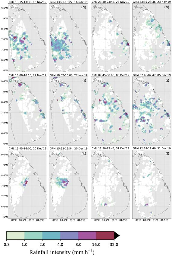
Environ. Res. Lett. 16 (2021) 074058 https://doi.org/10.1088/1748-9326/ac0fa6
LETTER
Tropical rainfall monitoring with commercial microwave links
OPEN ACCESS
in Sri Lanka
RECEIVED
30 January 2021 Aart Overeem1,2,∗, Hidde Leijnse1,2, Thomas C van Leth2, Linda Bogerd1,2, Jan Priebe3,
REVISED Daniele Tricarico3, Arjan Droste2 and Remko Uijlenhoet2,4
22 June 2021
1
ACCEPTED FOR PUBLICATION
R&D Observations and Data Technology, Royal Netherlands Meteorological Institute (KNMI), Utrechtseweg 297, 3731 GA De Bilt,
29 June 2021 The Netherlands
2
Hydrology and Quantitative Water Management Group, Wageningen University & Research, Wageningen, The Netherlands
PUBLISHED 3
16 July 2021 AgriTech/Mobile for Development, GSM Association (GSMA), London, United Kingdom
4
Department of Water Management, Faculty of Civil Engineering and Geosciences, Delft University of Technology, Delft,
The Netherlands
Original Content from ∗
Author to whom any correspondence should be addressed.
this work may be used
under the terms of the E-mail: aart.overeem@knmi.nl
Creative Commons
Attribution 4.0 licence. Keywords: commercial microwave links, rainfall monitoring, remote sensing, hydrometeorology, opportunistic sensing,
Any further distribution global precipitation measurement mission
of this work must
maintain attribution to Supplementary material for this article is available online
the author(s) and the title
of the work, journal
citation and DOI.
Abstract
Commercial microwave links (CMLs) from cellular telecommunication networks can provide a
valuable ‘opportunistic’ source of high-resolution space-time rainfall information, complementing
traditional in-situ measurement devices (rain gauges, disdrometers) and remote sensors (weather
radars, satellites). Their greatest potential lies in areas with low gauge densities and lack of weather
radars, often in developing countries with a subtropical or tropical climate and generally large
spatial rainfall variability. Here, the open-source R package RAINLINK is employed to retrieve
CML rainfall maps covering the majority of Sri Lanka for a 3.5 month period based on CML data
from on average 1140 link paths. These are compared locally to hourly and daily rain gauge data, as
well as to rainfall maps from the dual-frequency precipitation radar on board the global
precipitation measurement core observatory satellite. The potential of CMLs for real-time tropical
rainfall monitoring is demonstrated.
1. Introduction Asia and Latin America) largely depend on satellite-
based rainfall observations. Satellite estimates, how-
Accurate and timely surface precipitation measure- ever, are still associated with large uncertainty and
ments with high spatial and temporal resolution are often have a low spatial or temporal resolution (Kidd
of paramount importance for many applications such and Huffman 2011, Li et al 2021). Since rainfall dis-
as water resources management, agriculture (irrig- plays large variability in space, the current cover-
ation scheduling and crop insurance) and weather age by radars and rain gauges and accuracy of satel-
prediction. However, the majority of the Earth’s lites are often not sufficient for many applications
land surface lacks rainfall data of sufficient qual- such as short-term weather forecasting, flood pre-
ity. The total number of rain gauges from opera- diction and water balance monitoring. This calls for
tional meteorological networks is estimated to be at alternative sources of near-surface rainfall informa-
most ∼0.25 million, while the number of those giv- tion to complement the dedicated sensors to improve
ing useful near-real time observations is estimated the quality, spatio-temporal resolution and coverage
to be 8000–12 000 (Kidd et al 2017). Networks are of quantitative precipitation products. Examples of
especially sparse in developing countries (Lorenz and these alternative sources, also referred to as ‘oppor-
Kunstmann 2012). Moreover, in these areas the cov- tunistic sensors’, are windshield wipers (Rabiei et
erage of ground-based weather radars is also lim- al 2013), crowdsourced internet of things personal
ited (Saltikoff et al 2019). Hence, many regions over weather stations (De Vos et al 2019a), and satel-
the globe (particularly in Africa, South and Southeast lite broadcast receivers (Mercier et al 2015). These
© 2021 The Author(s). Published by IOP Publishing Ltd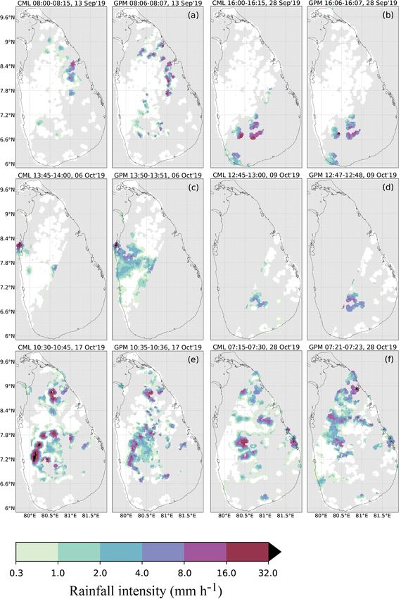
Environ. Res. Lett. 16 (2021) 074058                                                                  A Overeem et al

sensors—often not even designed to measure rain—           simulations of electromagnetic scattering by rain
fit the rise in demand for environmental opportun-         drops (Leijnse et al 2008), preferably for the local
istic sensing (Muller et al 2015, Zheng et al 2018).       climate. Alternatively, the values recommended by
     Here, we present one of the most promising            Int. Telecommunication Union (2005) can be used
sources of opportunistic sensing of rain: commer-          as a first guess. The acquired path-averaged rainfall
cial microwave links (CMLs), also known as point-          intensities over a link network can subsequently be
to-point or backhaul links. CMLs, called links from        interpolated to rainfall maps (Overeem et al 2013).
now on, are close to the ground radio connec-              Comprehensive overviews on the history and physics
tions used globally in cellular telecommunication net-     of link rainfall retrieval have been published (Messer
works. Along such links, radio signals propagate from      and Sendik 2015, Uijlenhoet et al 2018, Chwala and
a transmitting antenna at one base station (radio          Kunstmann 2019).
site, telephone tower or node) to a receiving antenna           We highlight two important sources of error
at another base station (figure 1(c)). A link often        in link rainfall estimation. First, signal levels often
consists of multiple sub-links, mainly to allow for        decrease during dry periods, e.g. caused by reflec-
communication in both directions. Links operate at         tion of the beam, dew formation on the antennas,
frequencies where raindrops substantially attenuate        and dust. Wet antennas and strong humidity and
radio waves (Hogg 1968, Atlas and Ulbrich 1977,            temperature gradients in the atmosphere may lead
Olsen et al 1978). In rainy circumstances, signals lose    to an altered antenna pattern or to refraction of the
their strength as they propagate from a directional        beam along the link path (Upton et al 2005, Overeem
antenna on one base station to a directional antenna       et al 2011, Chwala et al 2012, Doumounia et al 2014,
on another base station within each other’s line of        Messer and Sendik 2015). Hence, a reliable classifica-
sight. This is caused by absorption and scattering of      tion of wet and dry periods is needed to prevent erro-
microwaves by raindrops, which have sizes of a few         neous rainfall estimates during dry periods (Overeem
millimeters. Hence, these raindrops are only slightly      et al 2011, 2016b, Polz et al 2020). Moreover, this is
smaller than the typical wavelength of approximately       also needed to determine a reliable reference signal
1 cm employed by links. The harder it rains, the more      level, which is representative for dry periods. Here, we
raindrops will be present on the path between trans-       apply a method which considers the mutual decrease
mitter and receiver and the larger these drops will        in received signal levels from surrounding links to
be on average. As a consequence, the attenuation of        determine whether it is raining or not. Second, anten-
the microwave signal increases with higher rainfall        nas may also get wet during rain. Hence, a wet
rates.                                                     antenna attenuation correction is commonly applied,
     Rain-induced attenuation and, subsequently,           to avoid overestimation due to a water layer on the
path-averaged rainfall intensity can be retrieved          antenna(s) (Kharadly and Ross 2001, Leijnse et al
from the signal’s attenuation between transmitter          2007a, 2007b, Schleiss et al 2013). Systematic descrip-
and receiver (Upton et al 2005, Messer et al 2006,         tions of encountered sources of error and methods
Leijnse et al 2007a). If transmitted signal levels are     to account for these using quality control and rain-
constant, the rain-induced attenuation over the link       fall retrieval algorithms are provided by Overeem
path can be computed by subtracting the received           et al (2016a, 2016b) and Graf et al (2020).
signal level from a reference received signal level, the        Since approximately 2005, a growing community
latter being representative for dry periods. Altern-       of researchers (Gosset et al 2016) has, in close col-
atively, in case of variable transmitted signal levels,    laboration with mobile network operators, developed
the total attenuation over the link path must be used      retrieval algorithms to convert the raw link signals to
instead of received signal levels. This attenuation is     rainfall estimates. So far, this has resulted in tens of
computed by subtracting received signal levels from        peer-reviewed scientific publications, which demon-
transmitted signal levels. A reference total attenuation   strate the potential of link rainfall monitoring in the
during dry conditions must be computed similarly.          Czech Republic (Fencl et al 2015), France (Schleiss
Sometimes transmitted signal levels are unknown,           et al 2013), Germany (Chwala et al 2012, Graf et al
but known to be varying; obviously, this method            2020), Israel (Messer et al 2006, Rayitsfeld et al 2012),
cannot be used in that case. The core of link rainfall     Italy (Roversi et al 2020), the Netherlands (Leijnse
retrieval is physics-based and computes the path-          et al 2007a, Overeem et al 2013, 2016b, De Vos et al
averaged rainfall intensity from the rain-induced          2019b), and Switzerland (Bianchi et al 2013a). A key
microwave specific attenuation (dB km−1 ), i.e. the        advantage is that the required infrastructure is already
average attenuation per km along a link path due           in place, in the form of the ∼5 million links in global
to absorption and scattering of microwaves by rain         use (Ericsson 2018) by mobile network operators,
drops. The relation between the two takes the form         who typically store the required signal level data in
of a power-law (Atlas and Ulbrich 1977, Olsen et al        their network management systems to monitor net-
1978) of which the coefficients depend mainly on           work stability. Typically, minimum and maximum,
signal frequency and polarization, and are derived         average, or instantaneous received signal level data are
from measured rain drop-size distributions and             stored every 15 min.

                                              2
Environ. Res. Lett. 16 (2021) 074058 A Overeem et al
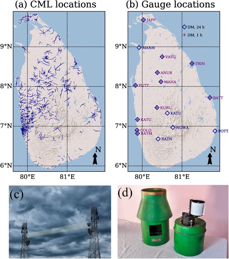
Figure 1. (a) Map of Sri Lanka with locations of the 1326 link paths from the cellular telecommunication network which provide
a rainfall estimate for at least one time interval during the 3.5 month period (left). (b) Map of Sri Lanka with the 16 locations of
the Sri Lanka Department of Meteorology rain gauges used in this study: 11 out of 12 providing hourly data (crosses) and 16 out
of 23 providing daily data (diamonds) were selected, because the nearest commercial microwave link (CML) was on average
within 5 km. (c) Illustration of a CML (source: identim/Shutterstock). (d) Photograph of type of rain gauge used in this study
(provided by the Sri Lanka Department of Meteorology). © 2014 Esri for the used base maps.
Currently, link rainfall estimation has been be automatically disseminated. For instance, charts
primarily demonstrated for temperate and Mediter- from the self-recording pluviographs in Sri Lanka,
ranean climates, with generally reasonable coverage used in this study, need to be manually read and
by dedicated sensors. Datasets with a few thousand digitized. Only few studies address link rainfall estim-
links were analyzed over a 2.5 year (Overeem et al ation in these regions. Good performance is found by
2016b) and a 1 year period (Graf et al 2020) over the Doumounia et al (2014) for one sub-link in Burk-
Netherlands and Germany, respectively. However, ina Faso over a 2 month period and by Sohail Afzal
the greatest potential of link rainfall estimation is et al (2018) for 35 sub-links in Pakistan over a 55
in low- and middle-income countries with subtrop- day period. Hoedjes et al (2014) show a rainfall map
ical or tropical climates, with limited real-time rain- based on data from six sub-links in Kenya and com-
fall observations to capture the typical localized and pare it to a map of satellite brightness temperatures.
intense rain showers. Rain gauge data will not always Rios Gaona et al (2018) provide rainfall estimates for
3Environ. Res. Lett. 16 (2021) 074058 A Overeem et al
Brazil, based on 145 sub-links (95 link paths) over (western slopes of mountain massif). Monsoon winds
81 days. City-average rainfall dynamics for São Paulo from the Indian Ocean and Bay of Bengal, orography,
were captured, but mixed results were obtained for and migrations of the intertropical convergence zone
individual link estimates. Finally, pilot studies have cause strong seasonal variation in rainfall. About 20%
been performed in Nigeria and Sri Lanka (GSM of the land surface is in the wet zone (>2500 mm), the
Association 2019). rest is in the intermediate (1750–2500 mm) and dry
To assess the potential of links for rainfall mon- (900–1750 mm) zones (Malmgren et al 2003, Herath
itoring in tropical regions a thorough evaluation and Ratnayake 2004, Nisansala et al 2020, Sri Lanka
on much larger datasets is required. We contrib- Department of Meteorology 2020).
ute to this by employing the open-source R package The period we consider in this study runs from 12
RAINLINK (2020) to retrieve rainfall in Sri Lanka, a September to 31 December 2019. The period from 12
middle-income country. Rainfall in Sri Lanka’s cent- to 30 September falls within the Southwest Monsoon
ral mountains is important for hydropower and the (May–September), during which moisture from the
tea industry. The quality of tea is influenced by rain- Indian Ocean brings 100–3000 mm of rainfall. Rain-
fall amount, intensity and duration (Herath and Rat- fall is high in the southwest of the island and on the
nayake 2004). Furthermore, strong seasonal and spa- windward mountain slopes, with the latter receiv-
tial rainfall variability creates periodic water shortages ing up to 2500 mm per month. Leeward slopes in
for irrigated agriculture and households. Both rain- the east and northeast receive little rain. This is fol-
fed and irrigated agriculture is important for exports lowed by the second intermonsoon from October
for Sri Lanka. Understanding spatio-temporal rain- through November, when the intertropical conver-
fall variability and improving rainfall forecasts may gence zone migrates southward over Sri Lanka. High-
help in, for example, planning crop cultivation and intensity rainfall events as well as the associated influ-
drainage channels for flood mitigation, or in design- ence of large-scale weather systems (such as tropical
ing water storages (Jayawardene et al 2005). Here, we depressions and cyclones originating in the Bay of
employ link data from, on average, 1140 link paths Bengal) are common. Such weather systems lead to
over a 3.5 month period. Link rainfall maps are com- strong winds with widespread rain over the whole
pared to hourly and daily rainfall depths from 11 and of Sri Lanka, which can sometimes result in floods
16 official meteorological stations, respectively. Given and landslides. Almost all of Sri Lanka experiences
the absence of weather radars and the limited quality over 400 mm of rain in this period, with the south-
of many satellite precipitation products, for the first western slopes obtaining 750–1200 mm. This is fol-
time link rainfall maps are compared to those from lowed by the Northeast Monsoon which runs from
the Dual-frequency Precipitation Radar on board the December through to February and is accompan-
global precipitation measurement (GPM) core obser- ied by dry and cold winds from India and mon-
vatory satellite (Hou et al 2014, Skofronick-Jackson soon winds from the northeast, which bring mois-
et al 2017, 2018) for 12 events. This active satellite ture from the Bay of Bengal. Rainfall amounts vary
sensor will generally provide much better rainfall in space from 177 mm for the western coastal area to
estimates than those from passive satellite-based 1250 mm for the northeastern slopes of the moun-
sensors, although its temporal coverage is limited. tains (Malmgren et al 2003, Herath and Ratnayake
Note that GPM is the successor of the tropical rain- 2004, Nisansala et al 2020, Sri Lanka Department of
fall measurement mission building upon its legacy Meteorology 2020).
of precipitation estimation from space from 1997 to
2015 (Liu et al 2012, NASA 2021a, 2021b). 2.2. Commercial microwave link data
Minimum and maximum received signal levels over
15 min intervals were obtained for the period from 12
2. Data September to 31 December 2019, from part of the cel-
lular telecommunication network operated by mobile
2.1. Study area network operator Dialog Sri Lanka, covering the
Sri Lanka (65 610 km2 ; ∼22 million inhabitants) majority of Sri Lanka. Figure 1(a) shows the locations
is an island country in the Indian Ocean, located of the 1326 link paths for which rainfall estimates
in South Asia near the equator, southeast of India are obtained. Information on link path length L,
(figure 1(a)). It has a warm tropical monsoon climate employed microwave frequency f and link orienta-
tempered by ocean winds and considerable mois- tion is presented in figures 2(a)–(c). The majority
ture, with an average annual temperature of about of links is shorter than 5 km, the average link path
27◦ C in the lowlands. Steep orography is found in length being 4.7 km. Most links operate at frequen-
the mountain massif in the south central part with cies between 17 and 19 GHz. The orientation of links
a highest peak of ∼2500 m above m.s.l. The rest of is quite uniformly distributed over all directions. The
Sri Lanka is typically up to a few hundred meters employed carrier frequency decreases for increasing
above m.s.l. Mean annual rainfall varies from below link path lengths (figure 2(d)), because link networks
900 mm (southeast and northwest) to over 5000 mm have been designed to prevent signal loss and lower
4Environ. Res. Lett. 16 (2021) 074058 A Overeem et al
Figure 2. Percentage of links for a range of (a) link path length L (km), (b) microwave frequency f, and (c) link direction classes.
(d) Scatter density plot of f (GHz) against L. (e) Number of available sub-links and link paths per 15 min time interval over the
entire period. All analyses are based on commercial microwave link data for which rainfall estimates are available after running all
processing steps from RAINLINK. Figures were made with RAINLINK (as of version 1.2) functions ‘DataAvailability’ and
‘Topology’.
frequencies are less affected by attenuation. Higher Link metadata are coupled with signal level
carrier frequencies are generally used in (urban) areas data and an initial quality control is performed.
where more bandwidth is needed. Frequencies are Overeem et al (2016a) give a detailed description
generally lower compared to those in areas with a of the employed rainfall retrieval algorithm, the
temperate climate, in order to prevent signal loss due interpolation methodology and the implementation
to the more intense tropical rainfall. Figure 2(e) shows thereof in the RAINLINK software package, written
that the mean 15 min data availability varies in time, in scripting language R. Version 1.2 is used to retrieve
but is generally high. Rainfall estimates have been 15 min path-averaged rainfall intensities, which are
provided for, on average, 2134 sub-links and 1140 link subsequently interpolated to 15 min rainfall maps
paths (this is less than the 1326 link paths for which on a 0.02◦ (∼4 km2 ) grid. These are aggregated to
data are available due to filtering we apply on these hourly rainfall maps and to daily rainfall maps from
data) over the 3.5 month period. 08:30 to 08:30 local time (03:00 UTC) to match the
5Environ. Res. Lett. 16 (2021) 074058 A Overeem et al
measurement interval of rain gauges. RAINLINK’s interpolated (using bilinear interpolation) to match
default parameter settings (Overeem et al 2016a) are the link grid in order to compare the satellite and link
employed. Although these have been optimized for precipitation retrievals.
the Netherlands, which has a temperate climate, we
expect that these settings will yield acceptable rainfall
estimates. The entire processing chain is described in 3. Results
the supporting information (text S1) (available online
at stacks.iop.org/ERL/16/074058/mmedia). Figure 3 shows the cumulative daily rainfall depths
from links and gauges from 12 September until 31
2.3. Rain gauge data December 2019, the period being shorter in case of
Hourly and daily rain gauge data were obtained missing rain gauge data. Note that cumulative rain-
from the Sri Lanka Department of Meteorology for, fall can easily exceed 800 mm in 3.5 months, and can
respectively, 12 and 23 locations. Only those World even exceed 1500 mm. The variation with time of the
Meteorological Organization stations were selected rainfall depths from links and gauges agree reasonably
for which the average distance to the nearest antenna well. The magnitude is in good agreement for six loca-
of a link that has data available was within 5 km tions, reveals overestimation for one location, under-
during the 3.5 month period considered. This res- estimation for four locations, and severe underestim-
ulted in a selection of 11 gauges with hourly rain- ation for five locations.
fall depths and 16 gauges with daily rainfall depths A more quantitative evaluation is provided by
(figure 1(b)). The data are from a siphon type of the scatter plots of link hourly and daily rainfall
rain gauge, where a pluviograph was employed for depths against the gauge-based ones (figure 4). A
recording the hourly rainfall depths. The daily rainfall slight overestimation by links is found for hourly
depths were obtained from the same gauge by accu- rainfall, whereas for daily rainfall the average under-
mulating 3-h rainfall depths, which were measured estimation is 17.6%. This is probably caused by differ-
manually every 3 hours starting from 08:30 local time ences in availability and collection of hourly and daily
to the next day 08:30 local time (∼96% availability). A gauge data. The coefficient of determination (r 2 ; the
manual observation was performed by emptying the fraction of explained variance) is fairly large (0.57),
gauge in a measuring glass. The average availability although quite some scatter is found, as is confirmed
of hourly rainfall depths is lower due to mechanical by the coefficient of variation (CV) of the residuals of
problems (85%). 4.33. Here, the CV is defined as the ratio of the stand-
ard deviation of the residuals and the mean of the ref-
2.4. Satellite product erence. This scatter and the apparent large link rain-
The satellite-based precipitation estimates were fall depths for (near) zero gauge rainfall (false alarms)
retrieved from GPM’s combined precipitation can be a result of errors in link rainfall retrievals, but
product (based on the GPM Combined Radar- may also be related to the interplay between strong
Radiometer Precipitation Algorithm, version V06A). spatial rainfall variability and differences in link and
Within this dataset, precipitation retrieval is based gauge locations. Furthermore, gauge rainfall estim-
on both the radiometer and the dual-frequency pre- ates themselves are influenced by sources of error.
cipitation radar onboard the core observatory satel- Except for the underestimation, link rainfall estim-
lite, which has roughly one overpass per day for a ates vastly improve for daily rainfall (r 2 = 0.79 and
given location. This precipitation product distin- CV = 0.87), where spatial rainfall variability is gen-
guishes precipitation retrieval based on the frequency erally much smaller, such that differences in loca-
band used for retrieval. The normal swath is based on tions between links and gauges are expected to play
the Ku-band radar and has a wider scan range com- much less of a role. It is remarkable that links can
pared to the matched scan in which data from the Ku- even accurately capture daily rainfall depths over
and Ka-band radar is combined. Because of its wider 150 mm.
swath, precipitation estimates from the normal swath Finally, 15 min link rainfall maps are compared
were used in this study as we wanted to compare as to the satellite product for 12 events (figure 5). In
many events as possible. More information about this most cases the locations of rain areas agree reasonably
dataset can be found in Grecu et al (2016), Olson and well. One of the best matches is found for 17 Octo-
the GPM Combined Radar-Radiometer Algorithm ber 2019 (figure 5(e)): The entire event of link rainfall
Team (2018). All swaths covering Sri Lanka within maps is provided as supporting information (movie
the study period were analyzed and only those for S1) and shows realistic patterns of showers moving
which at least one pixel over the land surface of Sri across Sri Lanka during this Second Intermonsoon.
Lanka had surface precipitation >0 mm h−1 were Link and satellite rainfall maps may differ because
considered for further analysis. This results in a selec- the satellite only takes a snapshot during its overpass,
tion of 12 events for which both satellite and link data and hence does not provide an estimate for the entire
were available. Data from the selected events were 15 min interval. Moreover, low link network density
6Environ. Res. Lett. 16 (2021) 074058 A Overeem et al
Figure 3. (a)–(p) Cumulative rainfall depths. Comparison of commercial microwave link (CML) based daily interpolated rainfall
depths at the locations of gauges from the Sri Lanka Department of Meteorology which report daily rainfall depths. The red dots
indicate the days for which the maximum distance of the underlying 15 min data to the nearest link antenna is larger than 5 km,
and hence could have been large during rainfall.
in some areas may lead to lower-quality link rainfall one location the large distance (indicated by the red
estimates. dots in figure 3(k)) between the gauge and the nearest
link may have contributed to link rainfall underestim-
4. Discussion ation. Although differences in distance to the nearest
link do not seem to provide an explanation, link
It is rather speculative what causes differences in per- network density could differ between rain gauge loc-
formance among gauge stations (figure 3). Only for ations. Higher densities could capture local extremes
7Environ. Res. Lett. 16 (2021) 074058 A Overeem et al
Figure 4. Verification of commercial microwave link (CML) based interpolated rainfall depths at the locations of gauges from the
Sri Lanka Department of Meteorology which report hourly (a) and daily (b) rainfall depths. Also zero rainfall values have been
included.
more accurately. Possibly some locations have shorter climate and network conditions instead of using the
link paths, which may negatively affect results (De Vos parameter values found for the Netherlands, which
et al 2019b). Differences between link and gauge rain- has a temperate climate. This customization con-
fall estimates in figures 3 and 4 may also be caused by cerns the core of the algorithm: the coefficients of
sources of error in gauge rainfall observations, which the power-law between path-average rainfall intens-
may vary between gauge locations. For instance, daily ity and specific attenuation, and the mixing of min-
rainfall depths are based on eight manual observa- imum and maximum received signals to derive aver-
tions and can hence be affected by reading errors. age rainfall intensities. The power-law coefficient and
Rain gauges can malfunction due to dirt (Steiner et al exponent for a given microwave frequency are derived
1999) and turbulence can lead to undercatch (Pollock from measured rain drop-size distributions and sim-
et al 2018). A more extensive reference network would ulations of electromagnetic scattering by rain drops
be needed in order to draw more definite conclusions (Leijnse et al 2008). This requires drop-size distribu-
regarding link-gauge differences. tion measurements from the considered region or a
When only gauge estimates above 1 mm are con- similar climate. The relative contribution of the min-
sidered (i.e. a subset of figure 4), an underestima- imum and maximum received signals depend on the
tion of 15.6%, a r 2 of 0.58 and a much better CV probability density function of path-averaged rain-
of 0.86 is found for hourly rainfall (1422 values). fall intensities typical for the region. This parameter
For daily values over 1 mm we find an underestim- can hence be derived from such probability density
ation of 18.6%, a worse r 2 of 0.75 and a better CV information, but also by means of a statistical calib-
of 0.63 (929 values). This performance for daily rain- ration by comparing to a reference dataset (Overeem
fall above 1 mm is better than what was found for the et al 2016a, De Vos et al 2019b). Such a calibration
Netherlands (∼35 000 km2 ), except for the stronger can also be used to optimize other parameters for the
underestimation: Overeem et al (2016b) report an region, preferably by using a stochastic optimization
underestimation of 7.8%, a r 2 of 0.59 and a CV of that optimizes RAINLINK’s most important para-
0.67. This is based on rainfall maps from a dense meters for wet-dry classification and rainfall retrieval
link network spanning about 7 summer months, separately (Wolff et al 2021).
with a gauge-adjusted radar rainfall dataset as refer- Messer and Sendik (2015), Uijlenhoet et al (2018)
ence. The current results are quite remarkable since and Chwala and Kunstmann (2019) provide detailed
RAINLINK’s parameters have not been optimized for discussions on (the sources of error of) different
the Sri Lankan climate. We think this can be partly rainfall retrieval and mapping algorithms, where
explained by the generally higher rainfall intensit- Overeem et al (2016a, 2016b) specifically focus on
ies in Sri Lanka. Then the influence of wet antenna RAINLINK and its applicability. To gain a better
attenuation and errors in wet-dry classification will be understanding of differences between link and refer-
relatively small. Still, it is recommended to custom- ence data, notably the underestimations in cumulat-
ize the rainfall retrieval algorithm settings for local ive rainfall against gauges for several locations, would
8Environ. Res. Lett. 16 (2021) 074058 A Overeem et al
Figure 5. (a)–(l) Comparison of commercial microwave link (CML) based 15 min rainfall maps (left) versus those from a satellite
product, the GPM combined precipitation product (based on the GPM Combined Radar-Radiometer Precipitation Algorithm,
version V06A; right) for 12 rainfall events over Sri Lanka from 2019 (two panels per event). For the rainfall event on 17 October
(e) a movie is provided in the supporting information (movie S1). Time is in UTC. Only areas with combined satellite and link
coverage are plotted, the latter implying that the nearest link antenna is within ∼5 km for the given time interval. White areas
denote a rainfall intensity less than 0.3 mm h−1 . Grey areas do not have combined satellite and link coverage.
9Environ. Res. Lett. 16 (2021) 074058 A Overeem et al
Figure 5. (Continued.)
require a detailed study of sources of error. This could combined with time lapse cameras to monitor the
be accomplished by employing local weather station link antennas and the link path (Van Leth et al 2018).
data and a dedicated research experiment with rain Such an experiment would also provide opportun-
gauges and disdrometers (instruments that meas- ities to improve link rainfall retrieval algorithms
ure raindrop size distributions) along a link path (Wang et al 2012).
10Environ. Res. Lett. 16 (2021) 074058 A Overeem et al
5. Conclusions a gauge-adjusted radar rainfall dataset over the Neth-
erlands. The 7 month evaluation shows that links out-
These are the main conclusions from this study: perform satellite rainfall products, highlighting the
potential for improving satellite products through
• An unprecedented CML dataset in terms of spatial merging with link rainfall estimates.
and temporal coverage was used for rainfall map- A number of hurdles have to be overcome before
ping in the tropical country Sri Lanka. (merged) link rainfall products can be used oper-
• A spatial comparison with a high-quality satel- ationally. First, gaining access to link data is usu-
lite product (Grecu et al 2016) and an extensive ally difficult and is typically achieved by contacting
local comparison with rain gauge data confirms mobile network operators on a country-by-country
the potential of microwave links for detailed trop- basis. Here, we obtained link data from Sri Lanka
ical rainfall monitoring over land. by the active involvement of the Mobile for Devel-
• The density of the link network is generally much opment AgriTech program of the GSM Association.
higher than that of gauge networks providing sub- The GSMA represents the interests of mobile net-
daily data. For example, the Sri Lanka Department work operators worldwide. Ideally, link data should
of Meteorology operates 23 official meteorological be openly available to enable the development of rain-
stations providing hourly rainfall for the entire fall products. Support from the World Meteorological
country, whereas data from, on average, 1140 link Organization, the International Telecommunication
paths were available in this study. This is only part Union, space agencies, meteorological satellite agen-
of the network of one of the mobile network oper- cies and policy makers could foster this.
ators active in Sri Lanka. Second, several technical issues need to be
addressed. Metadata (comprising link locations,
6. Outlook lengths, frequencies, polarizations, etc) are often not
present in the link data files, while such data are cru-
Only satellites can provide precipitation informa- cial in converting link data to rain estimates. Coupling
tion on a global basis, albeit with issues concerning of available metadata to the data files is challenging
accuracy (Kidd and Huffman 2011). For instance, the and time-consuming because of large variation of
IMERG product of the GPM mission is a gridded storing metadata between mobile network operators,
rainfall dataset covering 60◦ N–60◦ S with a spatial and the sometimes ambiguous or missing inform-
resolution of 0.1◦ and an interpolated temporal resol- ation therein. This calls for standardization of link
ution of 30 min (Hou et al 2014). This coverage can- (meta)data at the link vendor level, for which the pre-
not be achieved with CML, rain gauge or radar net- liminary HDF5 data format standard ‘cmlh5’ could
works, also because they are virtually absent above the be used as a starting point (cmlh5 2020). Additionally,
71% Earth’s surface consisting of oceans. The advant- the data management of mobile network operators is
age of cellular telecommunication networks is that not geared toward (continuous real-time) delivery of
they are ubiquitous in populated areas, covering more link data to other parties. Ultimately, an application
than 90% of the world’s population (International programming interface (API) should be developed
Telecommunication Union 2020). In 2007, already which can handle link data acquisition, the coupling
20% of the Earth’s land surface was covered by cel- of data and metadata, the rainfall retrieval and the
lular telecommunication networks (GSM Association dissemination of rainfall information. Implementing
2012). Hence, CMLs in these networks could provide an open source data acquisition system may help to
accurate and much more detailed rainfall informa- gain link data more easily and would increase control
tion in populated areas, where the impact of severe of the involved sampling up to 1 s (Chwala et al 2016).
weather is expected to be largest. Third, in order to perform a thorough scientific
Links are a complementary source of rainfall evaluation of their performance, rainfall retrievals
information and are not meant to replace exist- from the typically hundreds to thousands links from
ing observational networks. Once the quality of link preferably one or more years need to be evaluated for
rainfall estimates has been established for a cer- each network and region. Also, initial quality con-
tain region, these are ultimately merged with rain- trol of (meta)data may be needed. This requires good
fall products from dedicated sensor networks (Grum reference data, which are especially scarce in subtrop-
et al 2005, Overeem et al 2012, Bianchi et al 2013b, ical and tropical areas. A satellite combined radar-
Haese et al 2017). For developing countries in sub- radiometer product provides a means to perform a
tropical and tropical areas, link and satellite rain- spatial comparison, but typically only once a day.
fall products could be merged. In these areas, the Also customizing retrieval and mapping parameters
high spatio-temporal resolution and accuracy of links to the local climate and network is recommended,
is unmatched, complementing the large coverage of although we have shown here that using stand-
satellites. Rios Gaona et al (2017) evaluate the IMERG ard parameters derived for a very different region
product of the GPM mission, two geostationary rain- (the Netherlands) yields remarkably good rainfall
fall products and link-based rainfall estimates against estimates.
11Environ. Res. Lett. 16 (2021) 074058 A Overeem et al
Fourth, business models need to be developed. Acknowledgment
Link data will feed into a range of applications, from
improving and localizing weather forecasting ser- We thank Jenny Prosser (formerly GSMA) for estab-
vices, early warnings (e.g. landslides), crop produc- lishing contacts with mobile network operator Dia-
tion monitoring, precision agriculture services, agri- log Sri Lanka. We are indebted to mobile network
cultural weather insurance and water management. operator Dialog Sri Lanka for providing the com-
For example, this data will allow national meteorolo- mercial microwave link (meta)data and for their
gical services or private weather companies to accur- assistance in interpreting the (meta)data. We thank
ately nowcast rainfall up to a few hours in advance, Matthew Strickland (GSMA) for obtaining the rain
which is currently not feasible given the absence of gauge data from the Sri Lanka Department of Met-
weather radars. Imhoff et al (2020) use link rain- eorology. We acknowledge the Sri Lanka Department
fall maps as input for the open-source algorithm of Meteorology for their help in answering questions
pySTEPS and demonstrate that link rainfall now- regarding the rain gauge data and for providing a
casts compare well to radar rainfall nowcasts over photograph of a rain gauge. We thank two anonym-
the Netherlands. In addition, engineering compan- ous reviewers for their constructive comments.
ies and water authorities could use these data to
improve (flash) flood forecasts (Brauer et al 2016). Funding sources
Weather micro-insurance products, specifically rain-
fall excess insurance, can be developed to cater to the This project was partially funded through the Enhan-
predominantly smallholder farming systems found in cing Digital and Innovations for Agri-food Systems
low- and middle-income countries. These applica- and Livelihoods (eDIAL) Programme of UK aid. It
tions present opportunities for mobile network oper- was granted to the GSMA Foundation (IATI Activity
ators to valorize their link data, either as a ‘data as ID: GB-GOV-1-300644-104), with Wageningen Uni-
a service’ product, or by co-developing the above- versity and Research as subcontractor.
mentioned services with relevant partner organiza-
tions, where other mobile network operator assets, ORCID iDs
such as delivery channels, location data, and mobile
money channels facilitate the creation of such ser- Aart Overeem https://orcid.org/0000-0001-5550-
vices (GSM Association 2019, 2021). This is also 8141
confirmed by the demonstrator project Microwave- Hidde Leijnse https://orcid.org/0000-0001-7835-
based Environmental Monitoring (MEMO 2020) 4480
from the Swedish Meteorological and Hydrolo- Thomas C van Leth https://orcid.org/0000-0003-
gical Institute and Ericsson, demonstrating live link- 1597-6041
based rainfall maps for Gothenburg and Stockholm Linda Bogerd https://orcid.org/0000-0002-7343-
(Sweden). 4542
To conclude, we hope that this study con- Arjan Droste https://orcid.org/0000-0003-0218-
tributes to enable real-time link rainfall monit- 5160
oring, especially in those subtropical and tropical Remko Uijlenhoet https://orcid.org/0000-0001-
regions around the world with few surface rainfall 7418-4445
observations.
References
Data availability statement
Atlas D and Ulbrich C W 1977 Path- and area-integrated rainfall
measurement by microwave attenuation in the 1–3 cm band
The satellite product, the global precipitation J. Appl. Meteorol. 16 1322–31
measurement (GPM) combined (CMB) pre- Bianchi B, Rieckermann J and Berne A 2013a Quality control of
cipitation product (based on the GPM Com- rain gauge measurements using telecommunication
microwave links J. Hydrol. 492 15–23
bined Radar-Radiometer Precipitation Algorithm, Bianchi B, van Leeuwen P J, Hogan R J and Berne A 2013b A
version V06A), can be freely obtained via variational approach to retrieve rain rate by combining
https://gpm.nasa.gov/data/directory. The gridded information from rain gauges, radars and microwave links
rainfall maps retrieved from CML data from Sri J. Hydrometeorol. 14 1897–909
Brauer C C, Overeem A, Leijnse H and Uijlenhoet R 2016 The
Lanka over the 3.5 month period can be freely effect of differences between rainfall measurement
obtained (Overeem 2021). The data generated and/or techniques on groundwater and discharge simulations in a
analysed during the current study are not publicly lowland catchment Hydrol. Process. 30 3885–900
Chwala C et al 2012 Precipitation observation using microwave
available for legal/ethical reasons but are avail-
backhaul links in the alpine and pre-alpine region of
able from the corresponding author on reasonable Southern Germany Hydrol. Earth Syst. Sci.
request. 16 2647–61
12Environ. Res. Lett. 16 (2021) 074058 A Overeem et al
Chwala C, Keis F and Kunstmann H 2016 Real-time data Hogg D 1968 Millimeter-wave communication through the
acquisition of commercial microwave link networks for atmosphere Science 159 39–46
hydrometeorological applications Atmos. Meas. Tech. Hou A Y, Kakar R K, Neeck S, Azarbarzin A A, Kummerow C D,
9 991–9 Kojima M, Oki R, Nakamura K and Iguchi T 2014 The
Chwala C and Kunstmann H 2019 Commercial microwave link global precipitation measurement mission Bull. Am.
networks for rainfall observation: assessment of the current Meteorol. Soc. 95 701–22
status and future challenges WIREs Water 6 e1337 International Telecommunication Union 2020 Measuring digital
cmlh5 2020 Github–cmlh5/cmlh5: a file format for commercial development - Facts and figures 2020, Geneva, Switzerland
(and other) microwave link data based on HDF5 (available (available at: www.itu.int/en/ITU-D/Statistics/Documents/
at: https://github.com/cmlh5/cmlh5) (Accessed 30 facts/FactsFigures2020.pdf ”)
December 2020) Imhoff R O, Overeem A, Brauer C C, Leijnse H, Weerts A H and
De Vos L W, Leijnse H, Overeem A and Uijlenhoet R 2019a Uijlenhoet R 2020 Rainfall nowcasting using commercial
Quality control for crowdsourced personal weather stations microwave links Geophys. Res. Lett. 47 e2020GL089365
to enable operational rainfall monitoring Geophys. Res. Lett. Int. Telecommunication Union 2005 Recommendation ITU-R
46 8820–9 P.838-3. Specific attenuation model for rain for use in
De Vos L W, Overeem A, Leijnse H and Uijlenhoet R 2019b prediction methods (available at: www.itu.int/dms_pu-
Rainfall estimation accuracy of a nationwide brec/itu-r/rec/p/R-REC-P.838-3-200503-I!!PDF-E.pdf)
instantaneously sampling commercial microwave link (Accessed 30 December 2020)
network: error dependency on known characteristics J. Jayawardene H, Sonnadara D and Jayewardene D 2005 Trends of
Atmos. Ocean Technol. 36 1267–83 rainfall in Sri Lanka over the last century Sri Lankan J. Phys.
Doumounia A, Gosset M, Cazenave F, Kacou M and Zougmore F 6 7–17
2014 Rainfall monitoring based on microwave links from Kharadly M M Z and Ross R 2001 Effect of wet antenna
cellular telecommunication networks: first results from a attenuation on propagation data statistics IEEE Trans.
West African test bed Geophys. Res. Lett. 41 6016–22 Antennas Propag. 49 1183–91
Ericsson 2018 Ericsson microwave outlook (available at: Kidd C A, Becker A, Huffman G J, Muller C L, Joe P,
www.ericsson.com/4a312c/assets/local/ Skofronick-Jackson G and Kirschbaum D B 2017 So, how
reports-papers/microwave-outlook/2018/ericsson- much of the Earth’s surface is covered by rain gauges? Bull.
microwave-outlook-report-2018.pdf) (Accessed 10 June Am. Meteorol. Soc. 98 69–78
2021) Kidd C and Huffman G 2011 Global precipitation measurement
Fencl M, Rieckermann J, Sýkora P, Stránský D and Bareš V 2015 Meteorol. Appl. 18 334–53
Commercial microwave links instead of rain gauges: fiction Leijnse H, Uijlenhoet R and Stricker J N M 2007a Rainfall
or reality? Water Sci. Technol. 71 31–7 measurement using radio links from cellular
Gosset M et al 2016 Improving rainfall measurement in gauge communication networks Water Resour. Res. 43 W03201
poor regions thanks to mobile telecommunication networks Leijnse H, Uijlenhoet R and Stricker J N M 2007b
Bull. Am. Meteorol. Soc. 97 ES49–ES51 Hydrometeorological application of a microwave link: 2.
Graf M, Chwala C, Polz J and Kunstmann H 2020 Rainfall Precipitation Water Resour. Res. 43 W04417
estimation from a German-wide commercial microwave Leijnse H, Uijlenhoet R and Stricker J N M 2008 Microwave link
link network: optimized processing and validation for 1 year rainfall estimation: effects of link length and frequency,
of data Hydrol. Earth Syst. Sci. 24 2931–50 temporal sampling, power resolution and wet antenna
Grecu M, Olson W S, Munchak S J, Ringerud S, Liao L, Haddad Z, attenuation Adv. Water Resour. 31 1481–93
Kelley B L and McLaughlin S F 2016 The GPM combined Li Z et al 2021 Two-decades of GPM IMERG early and
algorithm J. Atmos. Ocean Technol. 33 2225–45 final run products intercomparison: similarity and
Grum M, Kraemer S, Verworn H-R and Redder A 2005 Combined difference in climatology, rates and extremes J. Hydrol.
use of point rain gauges, radar, microwave link and level 594 125975
measurements in urban hydrological modelling Atmos. Res. Liu Z, Ostrenga D, Teng W and Kempler S 2012 Tropical rainfall
77 313–21 measuring mission (TRMM) precipitation data and services
GSM Association 2012 Universal access. How mobile can bring for research and applications Bull. Am. Meteorol. Soc. 93
communications to all (available at: 1317–25
www.gsma.com/publicpolicy/wp-content/uploads/ Lorenz C and Kunstmann H 2012 The hydrological cycle in three
2012/03/universalaccessfullreport.pdf) (Accessed 10 June state-of-the-art reanalyses: intercomparison and
2021) performance analysis J. Hydrometeorol. 13 1397–420
GSM Association 2019 Mobile technology for rural climate Malmgren B A, Hulugalla R, Hayashi Y and Mikami T 2003
resilience: the role of mobile operators in bridging the data Precipitation trends in Sri Lanka since the 1870s and
gap (available at: www.gsma.com/mobilefordevelopment/ relationships to El Niño–southern oscillation Int. J.
wp-content/uploads/2019/10/GSMA_AgriTech_Climate Climatol. 23 1235–52
_Report.pdf) (Accessed 10 June 2021) MEMO 2020 MEMO | SMHI: microwave-based environmental
GSM Association 2021 Digital innovation for climate-resilient monitoring (available at: https://smhi.se/memo) (Accessed
agriculture: using rainfall data from mobile networks for 30 December 2020)
localised and scalable services (available at: www.gsma.com/ Mercier F, Barthès L and Mallet C 2015 Estimation of finescale
mobilefordevelopment/wp-content/uploads/2021/03/ rainfall fields using broadcast TV satellite links and a
Digital_Innovation_for_Climate_Resilient_Agriculture.pdf 4DVAR assimilation method J. Atmos. Ocean Technol. 32
(Accessed 10 June 2021) 1709–28
Haese B, Hörning S, Chwala C, Bárdossy A, Schalge B and Messer H A, Zinevich A and Alpert P 2006 Environmental
Kunstmann H 2017 Stochastic reconstruction and monitoring by wireless communication networks Science
interpolation of precipitation fields using combined 312 713
information of commercial microwave links and rain gauges Messer H and Sendik O 2015 A new approach to precipitation
Water Resour. Res. 53 10740–56 monitoring IEEE Signal Process. Mag. 32 110–22
Herath S and Ratnayake U 2004 Monitoring rainfall trends to Muller C L, Chapman L, Johnston S, Kidd C, Illingworth S, Foody
predict adverse impacts—a case study from Sri Lanka G, Overeem A and Leigh R R 2015 Crowdsourcing for
(1964–1993) Glob. Environ. Change 14 71–9 climate and atmospheric sciences: current status and future
Hoedjes J C B et al 2014 A conceptual flash flood early warning potential Int. J. Climatol. 35 3185–203
system for Africa, based on terrestrial microwave links and NASA 2021a TRMM (available at: https://trmm.gsfc.nasa.gov/)
flash flood guidance ISPRS. Int. J. Geo-Inf. 3 584–98 (Accessed 10 June 2021)
13Environ. Res. Lett. 16 (2021) 074058 A Overeem et al
NASA 2021b Two decades of precipitation measurement | NASA derived from satellites and microwave links for the
global precipitation measurement (available at: www.gpm. Netherlands IEEE Trans. Geosci. Remote Sens. 55 6849–59
nasa.gov/missions/two-decades-precipitation-measur- Rios Gaona M F, Overeem A, Raupach T H, Leijnse H and
ement) (Accessed 10 June 2021) Uijlenhoet R 2018 Rainfall retrieval with commercial
Nisansala W D S, Abeysingha N S, Islam A and Bandara A M K R microwave links in São Paulo, Brazil Atmos. Meas. Tech.
2020 Recent rainfall trend over Sri Lanka (1987–2017) Int. J. 11 4465–76
Climatol. 40 3417–35 Roversi G, Alberoni P P, Fornasiero A and Porcù F 2020
Olsen R L, Rogers D V and Hodge D B 1978 The aRb relation in Commercial microwave links as a tool for operational
the calculation of rain attenuation IEEE Trans. Antennas rainfall monitoring in Northern Italy Atmos. Meas. Tech.
Propag. 26 318–29 13 5779–97
Olson W S and the GPM Combined Radar-Radiometer Algorithm Saltikoff E et al 2019 An overview of using weather radar for
Team 2018 GPM combined radar-radiometer precipitation climatological studies: successes, challenges and potential
algorithm theoretical basis document (Version 5) (available Bull. Am. Meteorol. Soc. 100 1739–52
at: https://gpm.nasa.gov/sites/default/files/2020- Schleiss M, Rieckermann J and Berne A 2013 Quantification
05/Combined_algorithm_ATBD.V05.pdf) (Accessed 30 and modeling of wet-antenna attenuation for
December 2020) commercial microwave links IEEE Geosci. Remote Sens.
Overeem A 2021 Gridded rainfall maps retrieved from 10 1195–9
commercial microwave link (CML) data from Sri Lanka Skofronick-Jackson G et al 2017 The global precipitation
4TU.ResearchData. Dataset measurement (GPM) mission for science and society Bull.
(https://doi.org/10.4121/14166539.v2) Am. Meteorol. Soc. 98 1679–95
Overeem A, Leijnse H and Uijlenhoet R 2011 Measuring urban Skofronick-Jackson G, Kirschbaum D, Petersen W, Huffman G,
rainfall using microwave links from commercial cellular Kidd C, Stocker E and Kakar R 2018 The global precipitation
communication networks Water Resour. Res. measurement (GPM) mission’s scientific achievements and
47 W12505 societal contributions: reviewing four years of advanced
Overeem A, Leijnse H and Uijlenhoet R 2013 Country-wide rain and snow observations Q. J. R. Meteorol. Soc.
rainfall maps from cellular communication networks Proc. 144 27–48
Natl Acad. Sci. USA 110 2741–5 Sohail Afzal M, Shah S H H, Cheema M J M and Ahmad R 2018
Overeem A, Leijnse H and Uijlenhoet R 2016a Retrieval Real time rainfall estimation using microwave signals of
algorithm for rainfall mapping from microwave links in a cellular communication networks: a case study of
cellular communication network Atmos. Meas. Tech. Faisalabad, Pakistan Hydrol. Earth Syst. Sci. Discuss. (https://
9 2425–44 doi.org/10.5194/hess-2017-740)
Overeem A, Leijnse H and Uijlenhoet R 2016b Two and a half Sri Lanka Department of Meteorology 2020 Climate of Sri Lanka
years of country-wide rainfall maps using radio links from (available at: www.meteo.gov.lk/index.php?option=com_co
commercial cellular telecommunication networks Water ntent&view=article&id=94&Itemid=310&lang=en&
Resour. Res. 52 8039–65 lang=en#2-southwest-monsoon-season-may-september)
Overeem A, Leijnse H and Uijlenhoet R 2012 Quantitative (Accessed 30 December 2020)
precipitation estimation using commercial microwave links Steiner M, Smith J A, Burges S J, Alonso C V and Darden R W
Proc. Symp. on Weather Radar and Hydrology (Exeter, UK, 1999 Effect of bias adjustment and rain gauge data quality
April 2011) vol 351 ed R J Moore, S J Cole and A J control on radar rainfall estimation Water Resour. Res.
Illingworth (Wallingford: IAHS Press) pp 129–34 35 2487–503
Pollock M D et al 2018 Quantifying and mitigating wind-induced Uijlenhoet R, Overeem A and Leijnse H 2018 Opportunistic
undercatch in rainfall measurements Water Resour. Res. remote sensing of rainfall using microwave links from
54 3863–75 cellular communication networks WIREs Water 5 e1289
Polz J, Chwala C, Graf M and Kunstmann H 2020 Rain event Upton G J G, Holt A R, Cummings R J, Rahimi A R and
detection in commercial microwave link attenuation data Goddard J W F 2005 Microwave links: the future for urban
using convolutional neural networks Atmos. Meas. Tech. rainfall measurement? Atmos. Res. 77 300–12
13 3835–53 Van Leth T C, Overeem A, Leijnse H and Uijlenhoet R 2018 A
Rabiei E, Haberlandt U, Sester M and Fitzner D 2013 Rainfall measurement campaign to assess sources of error in
estimation using moving cars as rain gauges—laboratory microwave link rainfall estimation Atmos. Meas. Tech.
experiments Hydrol. Earth Syst. Sci. 17 4701–12 11 4645–69
RAINLINK 2020 Github—overeem11/RAINLINK: retrieval Wang Z, Schleiss M, Jaffrain J, Berne A and Rieckermann J 2012
algorithm for rainfall mapping from microwave links in a Using Markov switching models to infer dry and rainy
cellular communication network (available at: periods from telecommunication microwave link signals
https://github.com/overeem11/RAINLINK) (Accessed 30 Atmos. Meas. Tech. 5 1847–59
December 2020) Wolff W, Overeem A, Leijnse H and Uijlenhoet R 2021 Rainfall
Rayitsfeld A, Samuels R, Zinevich A, Hadar U and Alpert P 2012 retrieval algorithm for commercial microwave links:
Comparison of two methodologies for long term rainfall stochastic calibration Atmos. Meas. Tech. Discuss. (https://
monitoring using a commercial microwave communication doi.org/10.5194/amt-2021-34)
system Atmos. Res. 104–105 119–27 Zheng F et al 2018 Crowdsourcing methods for data collection in
Rios Gaona M F, Overeem A, Brasjen A M, Meirink J F, Leijnse H geophysics: state of the art, issues and future directions Rev.
and Uijlenhoet R 2017 Evaluation of rainfall products Geophys. 56 698–740
14You can also read