Location Platform Index: Mapping and Navigation, 1H18 - Key vendor rankings and market trends - BUSINESS GEOMATICS
←
→
Page content transcription
If your browser does not render page correctly, please read the page content below
Location Platform Index: Mapping
and Navigation, 1H18
Key vendor rankings and market trends

Publication Date: 20 Aug 2018   |   Product code: CES006-000033

Eden Zoller
Location Platform Index: Mapping and Navigation, 1H18
Summary
In brief
Ovum's 1H18 Location Platform Index is a tool that assesses and ranks the major vendors in the
location platform market, with particular reference to the mapping and navigation space. The index
evaluates vendors on two main criteria: the completeness of their platform and their platform's market
reach. It considers the core capabilities of a location platform along with the information that the
platform opens to developers and the wider location community. The index provides an overview of
the market and assesses the strengths and weaknesses of each player. It also highlights the key
trends in the mapping space that vendors must keep up with if they want to stay ahead of the game.
Ovum view
Indoor mapping is becoming as important as outdoor mapping . Indoor mapping covers
a wide range of potential use cases in the consumer, enterprise, and wider IoT domains.
Indoor mapping technology can help guide and track consumers at indoor venues from
shopping malls to stadiums. IoT use cases include tracking assets (e.g. equipment in a
factory or hospital); providing parking assistance to driverless cars; and guiding drones
delivering packages.
Advanced mapping is critical for autonomous driving, and autonomous driving data is
key to map enhancement. Highly automated driving (HAD) and HD and 3D maps help
advanced driver assistant systems (ADAS) and driverless vehicles to operate. And the data
surfaced by autonomous driving solutions is valuable for enhancing map accuracy. Mapping
vendors involved in autonomous driving, via their own solutions or partnerships, can benefit
from this virtuous circle.
Aerial mapping is taking off. There is a growing need for aerial maps as drones gain
traction in both private and commercial scenarios. As drone usage increases so will the
challenges of managing drone traffic in low-altitude airspace. There will also be a need to
coordinate drones with automated ground vehicles to ensure safety and efficiency.
AI assistants will be an important interface for connected car location services . AI
assistants (e.g. Apple Siri, Google Assistant) will take center stage in orchestrating voice-
activated, personalized digital services in connected vehicles and they will be the key
interface for mapping and navigation. The importance of digital assistants will grow as their AI
capabilities increase. AI assistants today do not understand cars or the nature of driving, but
this will change with advances in AI.
We are seeing the rise of the data marketplace . The huge growth in, and demand for,
location and mapping data will see the rise of data marketplaces, where stakeholders can
exchange and monetize location-centric data assets. However, for players to become
stakeholders, they will need considerable resources, a robust and proven location and
mapping platform, and advanced analytics back-up.
Mobility services have evolved from standalone apps to integrated solutions . The
evolution of mobility services from standalone applications to integrated solutions is leading to
the development of mobility-as-a-service (MaaS) propositions. These aim to provide
© Ovum. All rights reserved. Unauthorized reproduction prohibited. Page 2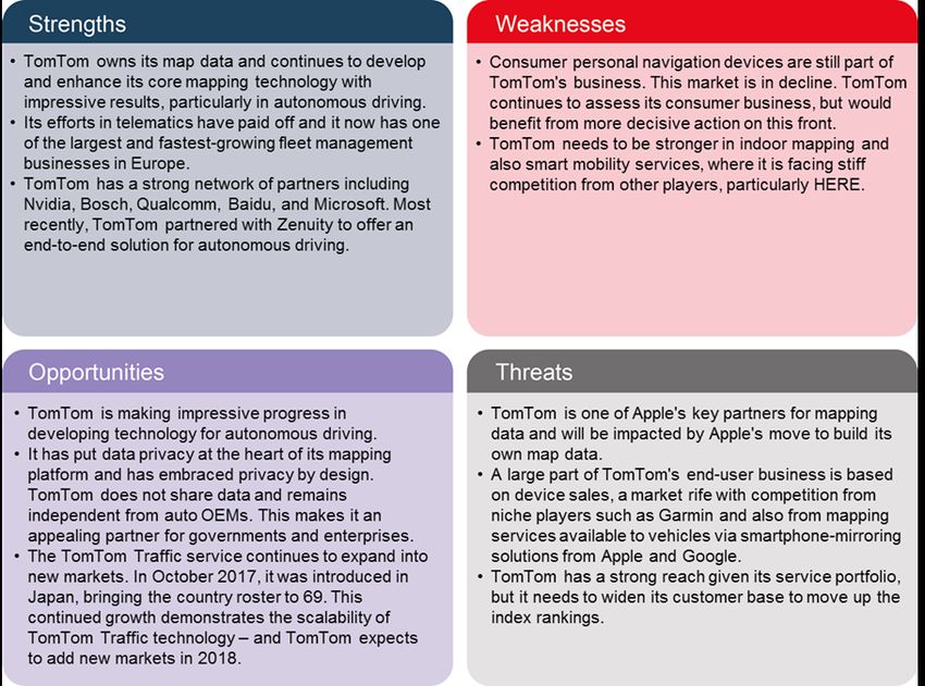
Location Platform Index: Mapping and Navigation, 1H18
personalized, real-time, and integrated mobility services and support a wide range of mobility
scenarios and multimode transport in a joined-up fashion. This is a tall order that should not
be underestimated.
Key messages
HERE topples Google to take first place .HERE has always scored well on the
completeness of its offering, leading on this front for some time. Where it traditionally lagged
Google was on the reach of its platform, but this has been steadily improving thanks to the
wide range of verticals its platform addresses. An important factor in HERE topping the leader
board has been its strong focus on the developer community: in 1H18 it carried out major
overhauls of its developer program and associated API pricing policy, which have been well
received.
Google Maps's new API pricing model could backfire – to the benefit of rivals. The new
Google Maps platform announced in 1H18 is a major overhaul and has some positive
elements, such as tighter integration with the Google Cloud Platform. In parallel with this,
Google has changed the pricing policy for its Maps APIs. The new pricing plan will prove more
expensive for some developers – to a high degree in certain scenarios. This has upset many
developers and could drive them to rival players, particularly HERE, Mapbox, and OSMF.
A bold move from Apple will take time to feed through .Apple's decision to generate its
own map data is significant, as to date it has been the only player among the leaders that
does not have its own mapping data. The Apple Maps reboot will not be available until later
this year with the release of iOS 12, so it does not affect Apple's score in this update of the
index. It will take time for Apple to gather a complete, deep data set across geographies.
Apple will also need to ensure it keeps data fresh and supports the latest capabilities and
innovations.
There is movement in the challenger segment, notably from Mapbox . In this iteration of
the index, ESRI and Mapbox have improved their scores, putting more distance between
themselves and other players in challenger segment. Mapbox has made particularly strong
progress, improving its score from 4.93 to 5.51 (placing it on the cusp of the leader segment).
The other challengers' scores are the same as before.
Players in the follower category are becoming commoditized . CloudMade has fallen off
the index in this update, largely because of its very niche focus. The remaining vendors in the
follower category have similar strengths in terms of the mapping data they have access to and
the APIs they enable. They must differentiate if they are to grow or they risk falling off the
index too.
Recommendations for vendors
Become a maestro of big data orchestration. To become mapping leaders, vendors must
be able to source, aggregate, and manage multiple data streams. Relying solely on sensor
data or a few additional data sets will not cut it in the longer term. Vendors should invest in
capabilities that improve their data orchestration abilities (notably machine learning) and form
partnerships that give access to new types of data.
Aim for accurate and fresh mapping data. A key quality of standout maps is coverage in
terms of geography and detail. But as top players improve coverage and gain parity with each
© Ovum. All rights reserved. Unauthorized reproduction prohibited. Page 3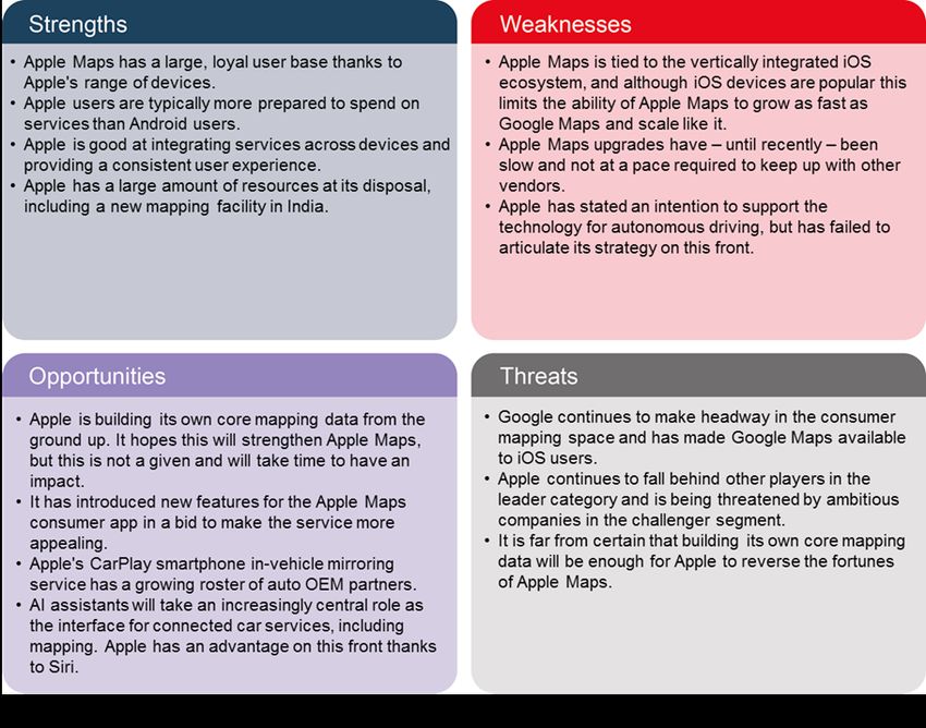
Location Platform Index: Mapping and Navigation, 1H18
other, the locus of differentiation and competition is shifting toward map accuracy and
freshness. To stay ahead, vendors need to invest in capabilities that maintain and update
maps automatically.
Formulate a long-term aerial mapping and drone strategy. Drone capabilities for mapping
and location vendors are important in the long term, even if there may not be significant
revenues in the short term. Vendors need to plan early how they can maximize drone data for
their platforms and work out how their platform or data can support drones.
Invest in your developer community. Given the right support, developers can be a source
of mapping innovation and, as a result, differentiation. Motivated developers can also become
platform evangelists, which has obvious benefits for the platform owner in question. Vendors
need to invest in the developer onboarding process to make it simpler, faster, and more
transparent. They must offer easy access to a range of high-quality APIs.
Embrace the power of crowdsourcing. Crowdsourcing can be a highly effective way to
improve the accuracy and quality of maps. Communities can provide valuable information
about local businesses and other places of interest in their area. Crowdsourcing is particularly
valuable in emerging markets, where mapping providers can often face "last-mile" challenges
in getting accurate data for addresses and other highly specific local information points.
Communities can also share feedback and suggestions and provide a channel for Q&A about
local business.
See vertical expertise as a source of strength and differentiation. Location and mapping
data is essential to certain industry verticals (e.g. autonomous driving, smart cities,
transportation, and logistics) and a key enabler for many others (e.g. digital advertising, sport
and fitness, supply chain management, government and public sector, asset tracking, retail,
travel and hospitality, real estate, and media and entertainment). Specialization in industry
verticals can help vendors differentiate, and for certain players in the index – such as Garmin
– this is their primary focus. More broad-based location and mapping vendors are looking to
strengthen their hand in key verticals too, as evidenced by HERE.
Results summary
Ovum's Location Platform Index, 1H18
The results for Ovum's 1H18 Location Platform Index are shown in Figure 1. The index evaluates
location platform vendors on two main criteria: the completeness of their platform and its market
reach. Both components play an equal role in determining the final rank of the vendor. The index
considers not only the core capabilities of a location platform but also the information that the platform
opens up to developers and the wider location community. It provides an overview of the market and
assesses the relative strengths and weaknesses of each player.
© Ovum. All rights reserved. Unauthorized reproduction prohibited. Page 4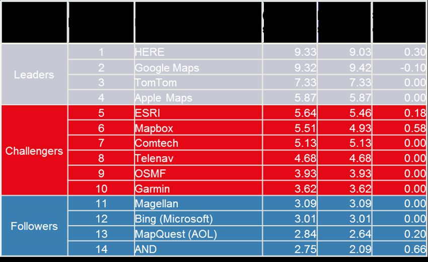
Location Platform Index: Mapping and Navigation, 1H18
Figure 1: Ovum's Location Platform Index, 1H18: player ranking
Source: Ovum
Reach and completeness
The index is based on two primary components: reach and completeness of the location platform.
Reach takes into account users of consumer-facing services and also enterprise customers. It
considers the size of the developer community that supports the platform, the number of
industries the vendor can cater to, and the number of automotive OEMs integrated into the
platform. The scoring reflects the extent of a player's market reach based on these factors.
Completeness describes the mapping, technology, and content assets that a player either
possesses or partners for. It also takes into account monetization strategy and the ability to
incorporate new technologies such as AI. The scoring reflects the extent of a player's
capabilities based on these attributes. The parameter measures mapping functions and map
strength, value-added services (VAS), monetization potential, data analytics capabilities, and
extent of collaboration.
Leaders
Figure 2 maps all the players in the index based on their reach and completeness scores. Leaders
(shown in gray) are those players with an overall score of 5.7 and above. They are positioned in the
top-right quadrant of the chart. Taken as a group HERE, Google, TomTom, and Apple stand out for
their dynamic service portfolio, focus on growing customers in both the consumer and enterprise
domains, and efforts to build on their core map service.
Challengers
Challengers (shown in red) are players with an overall score between 3.5 and 5.7. Over the past 18
months, the top-ranked vendors in the challenger segment have become more diversified, where
previously they had similar levels of platform completeness and reach. Competition among the top
challengers is intensifying as they try to break loose from the pack and climb into the leader category.
© Ovum. All rights reserved. Unauthorized reproduction prohibited. Page 5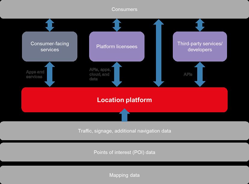
Location Platform Index: Mapping and Navigation, 1H18

Followers
Followers (shown in blue) are grouped in the lower-left quadrant and have a total score of less than
3.5. Vendors in this category are now similar in terms of reach and completeness. Followers need to
innovate faster, which in turn will help grow user numbers and enable them to move up the
categories. Failing to act will weaken their position.

Figure 2: Reach vs. completeness

Source: Ovum

In-depth results
Leaders
The leader group consists of four companies: HERE, Google, TomTom, and Apple Maps. Figure 3
shows their overall score for reach and completeness as well as their scores against the four criteria
for how completeness is measured: core mapping functions, VAS supported by the platform, closely
linked data and enablers (e.g. APIs, analytics capabilities, data sharing), and strength of monetization
strategy. Three of the four companies – Google, HERE, and TomTom – are major mapping data
providers. HERE and Google have been in the leader segment for the past six years and competition
between them remains intense. After steadily closing ranks on Google, in this iteration of the index
HERE has beaten Google to take the top spot. TomTom and Apple's rankings are the same as in the
last index, and there is no change in their scores. The first half 2018 saw Apple announce that it will
build its own mapping data, but this does not affect Apple's positioning in this update of the index and
is unlikely to for some time.

© Ovum. All rights reserved. Unauthorized reproduction prohibited.                             Page 6
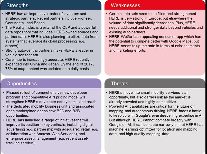
Location Platform Index: Mapping and Navigation, 1H18

Figure 3: Leaders' scoreboard

Source: Ovum

HERE: 1H18 highlights and developments to watch
HERE's reach is ratcheting up
A summary of HERE's SWOT analysis is shown in Figure 5. HERE is now the highest-ranking vendor
in the index with an overall score of 9.33. It has long been the top vendor for completeness and in this
iteration of the index, it has closed the gap with Google for reach, which is why it has been able to pull
ahead overall.

© Ovum. All rights reserved. Unauthorized reproduction prohibited.                               Page 7
Location Platform Index: Mapping and Navigation, 1H18

Figure 4: HERE SWOT

Source: Ovum

HERE's reach is accelerating to the point where it is snapping at Google's heels. There are a number
of factors driving this. HERE's Open Location Platform (OLP) is a compelling proposition that will help
the company attract new partners while providing a strong foundation on which to build services. OLP
version 1.5 went live in 1H18 and some of the advances from the previous beta version (1.0) include
the addition of live weather and real-time traffic data and improved location enrichment libraries.

HERE has an improved developer focus and has partnerships with some of the biggest cloud
marketplaces, notably Amazon Web Services (AWS). The company says that around 2 million
developers have leveraged HERE location services on AWS. HERE's new developer hub and pricing
model will help it gain further traction with developers, particularly given the dissatisfaction with the
controversial new pricing policy for Google Maps.

HERE now covers a diverse range of industry verticals: automotive, transport and logistics, public
sector and infrastructure, media, insurance, electronics, telco and utilities, retail, healthcare, real
estate, and consumer. Its direct consumer product reach is not as deep as that of Apple or Google,
but it is gaining ground. Consumer offerings include the HERE WeGo app for Android and iOS and
the here.com web-based proposition. HERE has close to 8 million monthly active users across the
three major platforms (Android, iOS, and Web).

There is no doubt that HERE is the leading mapping and location vendor in the automotive industry.
In 2017, the cumulative number of vehicles sold worldwide with HERE maps on board surpassed 100
million. According to the company, four out of five in-car navigation systems in Europe and North
America use HERE maps.

© Ovum. All rights reserved. Unauthorized reproduction prohibited.                               Page 8
Location Platform Index: Mapping and Navigation, 1H18

HERE goes all out in rallying developers
XYZ developer platform
HERE has completely overhauled its developer framework, with a new cloud location platform
designed to make it easier for organizations and end users to create maps. It sounds like a simple
objective, but a lot of work has gone into achieving this. HERE has placed a strong emphasis on
openness and interoperability: open source software and standards, support for multiple mapping
data sources, a transparent features road map, and the freedom to select developer tools. XYZ is also
designed to be highly responsive, with any data changes reflected in real time.

XYZ is available in three versions tailored to the needs of different developer segments, which is a
good move as one size does not fit all in the mapping developer community. The simplest iteration is
XYZ Studio for hobbyists, startups, SMEs, NGOs, and similar. Studio does not require coding and
provides templates and guidelines for quick map styling. The next iteration is XYZ Hub, the core
offering, which has additional capabilities including open, standards-based APIs that interoperate with
OSS. The third iteration is Hub Pro, designed for enterprises with professional-grade and SLA-
supported services, and large-scale processing (among other features). XYZ is being rolled out in
stages, starting with a beta launch for XYZ Studio and XYZ Hub in 2Q18, with Hub Pro following in
2019. HERE is staggering releases because it wants to ensure it builds in solid feedback cycles. This
will help it end up with the best possible developer framework based on what users want and need
most.
New mapping API pricing model
The other big change to HERE's developer program is a new pricing plan which appears more
developer friendly and competitive than the new Google Maps model. This should play to HERE's
advantage and bring long-term benefits to HERE's reach. Before the overhaul, HERE had multiple
pricing plans which could be confusing. It has scrapped these in preference for two core plans:
Freemium and Professional. The Freemium model is designed to lower price barriers for developers
by providing free access to 250,000 transactions per month, 5,000 software development kit (SDK)
active users, and 250 managed assets per month. Once developers cross the 250,000-transaction
threshold, they are charged $1 per additional 1,000 transactions, regardless of the mapping APIs
being called on (except for those relating to electronic horizons). The Professional plan costs $449
per month. It represents a discounted plan for developers likely to make less than 1 million API calls
per month – anything above this will require developers to arrange individual price plans with HERE.
Upping the ante with HD mapping
During 1H18, HERE announced initiatives that will bring long-term benefits to its work in HD mapping.
In April 2018, it opened a new R&D facility in Boulder, Colorado, which will focus on autonomous
driving and HD maps. In May 2018, HERE teamed up with its regional partners NavInfo (China),
Pioneer (Japan), and SK Telecom (South Korea) to form the OneMap Alliance. The alliance, which is
open to additional members, aims to create a global, standardized HD map offering, which will be
aligned with the specification developed for HERE's HD Live Map. The aim is to provide auto OEMs
with an easy access source for harmonized, scalable HD maps.

By the end of 2018, the HD Live Map will cover more than 1 million kilometers of road across North
America and Europe, providing information on configurations and markings, speed limits, and
shoulders, as well as on roadside objects and obstacles via vehicle localization. More than 20 auto
OEMs are using HERE's HD Live Map in their autonomous driving R&D. In 2H18, HERE announced

© Ovum. All rights reserved. Unauthorized reproduction prohibited.                             Page 9
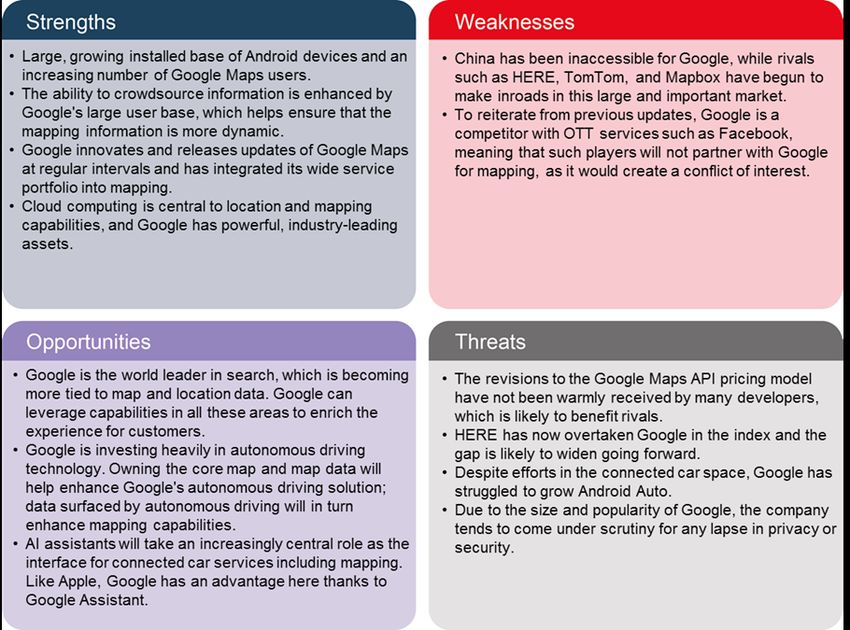
Location Platform Index: Mapping and Navigation, 1H18

its first commercial agreements for the HD Live Map via shareholders Daimler and BMW Group.
Daimler will use the HD Live Map in future Mercedes-Benzmodels while BMW is planning to feature
the HD Live Map in BMW models from 2020 onward.
Doubling down on indoor mapping
In 1Q18, HERE has ramped up its indoor mapping efforts via acquisitions and strategic partnerships.
This is a significant development, as indoor mapping is becoming an important attribute of
comprehensive map coverage. Increased indoor mapping capabilities will put HERE in a strong
position to exploit a wide range of potential use cases, in the consumer, enterprise, and wider IoT
domains. In March 2018, HERE completed the acquisition of Micello, a US firm with a specialist
platform for creating, editing, and publishing indoor maps. In February 2018, HERE signed a
preliminary agreement to collaborate on autonomous indoor 3D mapping technology with NAVER
LABS, the ambient intelligence arm of South Korea's leading internet company NAVER Corporation.
HERE's other indoor mapping partners include Motorola Solutions, Actility, and Decawave. HERE has
partnered with Motorola Solutionsto equip public safety responders with detailed venue maps for
enhanced situational awareness. Decawave and HERE are planning to work on an out-of-the-box
real-time and energy-efficient tracking solution. This will be based on ultra-wideband (UWB)
positioning technology and reveal the 3D positioning of objects and people down to 10 centimeters in
indoor environments. Actility is a specialist in LoRaWAN connectivity solutions and has a low-power
location solution that combines GPS, A-GPS, and Wi-Fi positioning.
HERE launches OTA Connect
In the last iteration of the index, we drew attention to HERE's acquisition of Advanced Telematics
Systems (ATS), which is the foundation for the new HERE OTA Connect service launched in May
2018. Over-the-air (OTA) solutions are useful to auto OEMs because they represent a fast, cost-
effective way to remotely update software and firmware, and OTA Connect can provide potential new
revenue streams by enabling customers to buy new services OTA. Software updates will become
even more important in the context of semi and fully autonomous software-defined vehicles, where
security will be paramount. HERE OTA uses Uptane, a security framework backed by the US
Department of Homeland Security. Uptane is designed specifically for software that runs on
connected and autonomous cars. OTA Connect is currently available as a standalone product but will
eventually be integrated into HERE's suite of automotive software and platform services, which will
help make the solution available for non-automotive use cases.

Google: 1H18 highlights and developments to watch
Google's large active user base is still one of its greatest strengths
A summary of Google Maps's SWOT analysis is shown in Figure 5. Google lost its top slot in the
rankings to HERE and has seen its overall score slide from 9.42 to 9.32.

A large part of Google's leading position is due to its extensive consumer reach and large active
developer base, which is hard for other vendors in the index to beat. Google Maps has more than 1
billion users and the potential for a much greater number given the size of the global installed base for
Android devices. Ovum predicts that this will rise from 3.68 billion in 2018 to 4.75 billion by 2022. The
total global installed base for all smartphones will hit 5.52 billion by 2022, which puts the scale of
Android smartphones into perspective.

© Ovum. All rights reserved. Unauthorized reproduction prohibited.                             Page 10
Location Platform Index: Mapping and Navigation, 1H18
Figure 5: Google Maps SWOT
Source: Ovum
The impact of the Google Maps Platform
The biggest development for Google Maps in 1H18 – and indeed for some time – was the
announcement of the new Google Maps Platform in May. This major overhaul to the structure and
pricing model of Google Maps has some far-reaching implications, and not all of them are positive
from a developer perspective.
Streamlined API structure and tighter integration with Google Cloud Platform
Google has grouped its 18 mapping and location-related APIs into three core products. The new API
structure aims to make it easier for developers and other third parties to access APIs, explore new
features, and integrate them with their services.
Maps APIs: Customized dynamic maps, Street View, and 360-degree views.
Routes APIs: Directions and traffic.
Places APIs: Location names, addresses, reviews, and so on.
Google Maps Platform will be more tightly integrated with Google Cloud Platform (GCP) services and
tools, which is a positive development. GCP offers good levels of capacity, reliability, and
performance, and integration with it should make it easier for developers to scale as a solution or
application grows. Developers and third parties will be able to manage the Google Maps Platform
from the Google Cloud Console, which is used for other GCP services. This will make it easier for
developers to manage and track projects, monitor APIs, and access billing reports, among other
things. Integration with GCP also gives developers free access to GCP customer support. Google is
no doubt hoping that developers will discover other GCP products.
© Ovum. All rights reserved. Unauthorized reproduction prohibited. Page 11Location Platform Index: Mapping and Navigation, 1H18 New pricing model is causing controversy The introduction of the Google Maps Platform has been accompanied by a new pricing model for Maps APIs. Google has merged the previous Standard and Premium pricing plans into a single monthly pay-as-you-go model for core API products. Under the new pricing plan, developers will only pay only for the services they use each month with no annual fees, upfront commitments, termination fees, or usage limits. Google is also throwing in free customer support, and developers will receive the first $200 of monthly API calls for free. Eligible not-for-profit organizations, crisis response organizations, news media companies, and some startups will be able to apply for extra free Maps credits. The new model is in line with many cloud computing providers and looks good on the surface, but in reality it is confusing, hard to navigate, and will certainly make budgeting hard until developers have come to grips with it. The freemium pricing model will prove more expensive for some developers, and to a high degree in certain scenarios and for certain APIs. The free $200-per-month cap is probably fine for more basic mapping applications, but not a big bonus for more complex solutions where costs can mount up under the new model. Although some applications that previously required a license will now be free, others that offered a daily bucket of free credits will be more expensive. The old Premium plan gave customers up to 100,000 free web service calls per day. The old Standard plan provided up to 25,000 map loads per day with no charge, as well as several free web service calls. To access APIs, developers will need to have valid API keys and a billing account with GCP, even if they are sure usage will fall within the free $200 monthly credit. This does not sound too onerous but has upset some developers and could inconvenience those with a wide range of APIs. Disgruntled developers might look elsewhere There is a very real danger for Google in that developers unhappy with the new pricing structure might look for alternative location and mapping platforms. The most likely beneficiaries from this situation will be immediate rivals such as HERE and Mapbox. Open source platforms such as OpenStreetMap might also benefit, as although they lack the depth of data and range of functionality offered by the likes of HERE, they are completely free. OpenStreetMap can support highly customized experiences thanks to the variety of JavaScript libraries available. Improvements to Google Maps consumer app continue Google has a solid track record of making continual – albeit not always radical – improvements to the Google Maps application. This contrasts with Apple's more stop-start approach to Apple Maps enhancements. Recent developments announced at the Google I/O developer conference include machine learning–driven personalization features. For example, Google is leveraging machine learning to predict places users might like, based on knowledge of the user and local places of interest. TomTom: 1H18 highlights and developments to watch TomTom's strong efforts in telematics continue A summary of TomTom's SWOT analysis is shown in Figure 6. TomTom's score remains stable (7.33) in this iteration of the index, keeping it in third place and ahead of Apple. © Ovum. All rights reserved. Unauthorized reproduction prohibited. Page 12
Location Platform Index: Mapping and Navigation, 1H18

Figure 6: TomTom SWOT

Source: Ovum

TomTom now has the largest and fastest-growing fleet management business in Europe. At the end
of 2Q18, TomTom had more than 848,000 fleet management and connected car subscribers, an
increase of 11% year on year. The business is providing additional benefits in the form of extensive
vehicle-related data and opportunities for aftermarket connected car services.

TomTom is continuing to improve WEBFLEET: in February 2018, it launched a redesigned version of
the software-as-a-service (SaaS), cloud-based fleet management platform. New features include a
more intuitive user interface with advanced customization capabilities; for example, WEBFLEET maps
and reports can be more deeply customized to suit individual preferences. Another new feature allows
specified route planning to be better managed by using a wider range of criteria. This is particularly
useful for industries where drivers are required to follow predefined routes, such as waste
management and disposal. The core platform architecture has been enhanced to enable faster
development and deployment of core features and partner applications. Alongside the revamped
platform, the company has also released a new range of TomTom Pro driver terminals.

TomTom's telematics business includes connected cars, and in 1Q18 the company announced that
from November 2018 Hyundai and from 2019 Kia will include TomTom's on-street and off-street
parking information, electrical vehicle services, and fuel prices as part of their connected car services.
In 1Q18, TomTom also launched its electrical vehicle service in North America.
Ramping up efforts in core mapping and autonomous driving
TomTom has a transactional mapmaking platform and data fusion technology which allow it to shorten
the map and traffic production cycle considerably. As a result, TomTom has been able to increase the

© Ovum. All rights reserved. Unauthorized reproduction prohibited.                              Page 13
Location Platform Index: Mapping and Navigation, 1H18

frequency of its map releases, from quarterly to weekly and, recently, daily. This is critical for
demanding location-based applications, such as mobility services and autonomous driving.

Apple's decision to build its own maps might affect TomTom. TomTom is currently one of the key data
partners for Apple Maps. In the short term, Apple will likely continue to rely on TomTom mapping
data, but this will inevitably decline over time as Apple builds up its own capabilities.

TomTom is advancing its autonomous driving opportunity via a growing network of partners and
strategic acquisitions. Key partners include Chinese search giant Baidu and Nvidia, a leader in AI
visual computing (among other things). In February 2018, TomTom announced a collaboration with
Elektrobit. The two companies will create a demonstrator, evaluation, and development platform for
electronic horizon functionalities for driver assistance and autonomous vehicles. The joint project
combines TomTom AutoStream and EB robinos Predictor.

TomTom is not as advanced as HERE or Google in HD mapping but is making good progress, with
more than 380,000km of roads mapped to the requirements of autonomous driving in mainland
Japan, the US, and Western Europe. TomTom has been collecting data through its RoadDNA
technology, one of the core elements to HD mapping. This will allow autonomous vehicles to become
aware of their environment, location, and path on the road. In late 2018 or 2019, TomTom expects a
yet-to-be-specified truck manufacturer to start using elements of its HD maps in motor management
applications – including those that automatically adjust speed for road curves or climbs.
Consumer business slide continues
TomTom's consumer business, driven by personal navigation devices (PNDs), continues to decline,
as does the wider PND market. In 2Q18, TomTom reported that revenues from its consumer business
decreased by 24% in the quarter and 25% in the first half. For full-2018, TomTom expects the decline
to be around 30%. There have been reports that TomTom might divest its consumer operations, but
the vendor has not confirmed this and may want to hold onto the business as it is still a cash
generator.

Apple Maps: 1H18 highlights and developments to watch
Incremental improvements have not yet moved the needle
A summary of Apple's SWOT analysis is shown in Figure 7. Apple Maps's score remains unchanged
(5.87) in this iteration of the index and is still the lowest in the leader category.

The last significant enhancement for Apple Maps was in September 2017 – as covered in the 2H17
iteration of the index. Many of the new features were already offered by Google Maps and standalone
GPS devices, although in some cases the Apple equivalents were arguably better. The bottom line is
that while welcome, the enhancements have yet to significantly move the needle for Apple Maps or
improve its positioning in the index.

© Ovum. All rights reserved. Unauthorized reproduction prohibited.                               Page 14
Location Platform Index: Mapping and Navigation, 1H18

Figure 7: Apple Maps SWOT

Source: Ovum

Strategy U-turn: Apple is building its own mapping data from the ground up
It has been clear for some time that Apple needs to take more drastic action to improve Apple Maps
given the increasingly competitive nature of the mapping and navigation market. It seems that Apple
has taken this on board with the announcement that it has been secretly building its own mapping
data which will enable it to reboot Apple Maps. The data is being gathered by Apple's own fleet of
sensor-equipped vehicles and from anonymous iPhone users that consent to share it. Alongside this,
Apple is gathering new high-resolution satellite data to layer with the drive data and iPhone data.

Tapping into real-time data from iPhones could prove compelling. Ovum forecasts that the global
installed base of iPhones will reach 609.8 million by the end of 2018 and rise to 729.3 million by the
close of 2022. This is a substantial user base, albeit not as large as that for Android smartphones.
Leveraging iPhone data hinges on users' willingness to share their location, and this is by no means a
given as location data can be deemed highly sensitive by consumers. Apple is at pains to stress
privacy is paramount in the data gathered from consumers' iPhones. The data is anonymized, and
only random points of a user's journey are collected. Rotating identifiers, rather than personal
information, are assigned to any data or requests sent to Apple.
A significant move with long-term implications
Apple's decision to generate its own mapping data is very significant, as to date it has been the only
player among the leaders not to have its own mapping data, relying instead on a mash-up of data
from TomTom, OpenStreetMap, and other location data brokers. Apple now sees total reliance on
third-party data as a weakness of Apple Maps (although at this point it looks like the partnership with

© Ovum. All rights reserved. Unauthorized reproduction prohibited.                            Page 15
Location Platform Index: Mapping and Navigation, 1H18

TomTom is still in place). Apple's decision not to own core mapping data has always seemed
surprising, as one of the company's guiding principles is to own and control everything as far as
possible. There are no precise details yet on the exact enhancements this overhaul this will enable,
which is understandable.
Whether Apple Maps's positioning improves remains to be seen
The Apple Maps reboot will not be available until later this year with the release of iOS 12; therefore it
does not affect Apple's score or ranking in this version of the index and may not do so until 2019. It
will take time for Apple to gather a complete deep data set across geographies, and improvements to
Apple Maps are more likely to be an iterative process rather than a "big bang." Gathering mapping
data is only the start. The project will require long-term commitment and investment to keep the data
fresh and to ensure that it supports the latest capabilities and innovations. Whether Apple's own
mapping data will be enough to reboot Apple Maps so that it competes better with HERE and Google
remains to be seen.

Challengers
The next group in Ovum's index is made up of players that scored more than 3.5 but less than 5.7
when scores for completeness and market reach were combined. This group consists of six
companies: ESRI, Mapbox, Comtech, Telenav, OpenStreetMap Foundation (OSMF), and Garmin.
The scores for the challengers are shown in Figure 8.

Figure 8: Challengers' scoreboard

Source: Ovum

© Ovum. All rights reserved. Unauthorized reproduction prohibited.                              Page 16
Location Platform Index: Mapping and Navigation, 1H18

Top four challengers: 1H18 highlights and developments to
watch
ESRI
ESRI's flagship product, ArcGIS, a specialist analytics and mapping tool, has been on the market
since 1999. Given its highly specialized product, ESRI works closely with vendors that might be
considered competitors. ESRI is the GIS market leader with customers in more than 30 industries
across the globe.

The vendor has a strong base of enterprise clients and a strong developer community which
contribute to its high score. It offers several pricing plans to suit a range of developers, including an
option that enables access to basic developer tools at no cost. This is important in attracting
developers to the platform, allowing them to trial the system at no cost while giving ESRI an upsell
opportunity for the paid-for plans. ESRI continues to innovate by adding e-commerce services and
analytics to its platform.
Indoor mapping, data collaboration, and cloud partners add to the ArcGIS
proposition
In July 2018, ESRI announced a deal with Waze to provide Waze live alert data in ArcGIS to
members of the Waze Connected Citizens Program, a data-sharing program of publicly available
information on traffic and road conditions. This will allow local governments to respond to incidents
more quickly and allow planners to analyze pinch points in greater detail. For instance, in Cobb
Country, Georgia, a trialist of the service was able to use the Waze data in the ArcGIS platform to find
the common factor behind a sequence of automobile accidents.

Also announced in July 2018 was a new indoor mapping feature for ArcGIS that will facilitate
interactive mapping for places such as airports, hotels, and event venues. The system can be linked
with key-card data and room sensors to give building managers and event planners real-time data on
their buildings. Indoor mapping could eventually enable navigation apps to direct users to an office
inside a large campus rather than simply to the campus or building entrance.

Since June 2018, ArcGIS has been integrated into SAP HANA spatial services to enable businesses
to create location bases and location-aware apps more quickly. SAP HANA is built on the SAP Cloud
Platform. Another cloud integration was announced in April 2018 with ESRI entering a collaborative
agreement with Alibaba Cloud to enable both companies to deliver ESRI technology on the Alibaba
Cloud to customers.
Comtech
Comtech offers a number of location services, including navigation and mapping, indoor networking
solutions, asset location, and mobile location services. It has a strong presence in China and 85 other
countries.

Comtech has not announced any improvements since the last update of the index but continues to
build its customer base, particularly in the automotive industry. Comtech is well placed in the
autonomous driving market and has provided its first OEM with HD maps. Comtech's navigation and
mapping solutions are enabled with enhanced search which can auto-suggest and offer premium
content such as local movie listings, gas prices, and events details.

© Ovum. All rights reserved. Unauthorized reproduction prohibited.                               Page 17
Location Platform Index: Mapping and Navigation, 1H18

Comtech's Location Studio offers a range of map-based services and is quick to adapt to new
technologies such as voice interfaces. The product is cloud ready and the company has around 1,000
active developers but can reach more than 100,000 developers via links to Arm Mbed, Samsung
Artik, and IBM BlueMix platforms. Developers can access a consistent set of APIs and SDKs across
all three map selections offered by Comtech. Location Studio can be used across a number of
verticals, including automotive, fleet management, and insurance.

Given the completeness of its product, Comtech is well placed for the future if it continues to grow its
reach.
Mapbox
Mapbox has moved up the rankings since the previous index, having continued to strengthen its
product offering and expand its reach. It has a number of high-profile users in diverse industries
including The Weather Channel, Lonely Planet, Snapchat, Strava, Financial Times, The Guardian,
Microsoft, and the FCC. These customers have put Mapbox's technology into the hands of 300 million
people every month.

Mapbox is primarily built on AWS and therefore is a cloud provider of location services and APIs.
Mapbox has a longstanding commitment to the open source community and currently has more than
660 public code repositories on GitHub. Mapbox continues to be one of the most flexible platforms in
the market, with open source libraries to help developers and other partners customize map
interfaces and attributes to a high degree. Mapbox, like Telenav, works with OSMF data and in turn
contributes back to the OSMF map to ensure it remains up to date.
Mapbox is keen to support its developer community
Mapbox has a good-sized developer community of more than 70,000 developers that build apps with
Mapbox every month and more than 1.1 million registered developers. Mapbox's service pricing is
clear and it offers some free usage in its pay-as-you-go price plan to encourage developers to explore
its tools. Mobile apps sold through an app store need not have a commercial license, which makes it
easy for developers to get started with the service. Mapbox focuses on developer tools, and its main
business is licensing these tools rather than offering its own consumer apps.

At Mapbox's Locate event in May 2018, Mapbox announced two augmented reality (AR) SDKs. The
React Native SDK will enable developers to build cross-platform AR apps more quickly as it allows
development on both iOS and Android simultaneously. The SceneKit SDK, meanwhile, enables
developers to add 3D terrain to iOS apps easily and without unduly increasing the size of the apps.
The SceneKit SDK is integrated with Apple's ARKit. These two SDKs will enable Mapbox's
development community to quickly and easily roll out all kinds of location-based AR games and
experiences.

In May 2018, Mapbox also announced a partnership with Arm and the upcoming Vision SDK to allow
developers to create a heads-up-display experience within navigation apps by using the phone's
camera as another sensor input to the navigation system. The partnership with Arm will help Mapbox
keep the power requirements of the Vision SDK low, and with Arm processors in billions of phones
around the world, this partnership could prove important.
Telenav
Telenav has established a niche within the US automotive industry and has already partnered with a
number of car manufacturers, including Ford, GM, and Toyota. Its embedded navigation within Ford

© Ovum. All rights reserved. Unauthorized reproduction prohibited.                             Page 18
Location Platform Index: Mapping and Navigation, 1H18

and Cadillac cars has been well received by the market, with the Ford SYNC 3 software rated as the
best overall navigation system by J.D. Power. Recently, Telenav's agreement with Ford for SYNC 3
was extended to 2020 for all current geographies. According to Telenav's 3Q18 financial results, there
are more than 8 million connected cars currently on the road that have Telenav's location-based
services platform, with 1.4 million deployed in the first three month of the 2019 calendar year.
Telenav looks to develop its machine-learning mapmaking platform
In July 2018, Telenav announced that its embedded navigation system is part of the Uconnect
platform featured in the 2018 Jeep Grand Commander which has been launched for the Chinese
market. Its embedded navigation will also appear in the Jeep Cherokee and the Jeep Compass when
they are launched in China in 2018. This is a further push into the Chinese market for Telenav which
has its main presence in the US and lacks a global presence.

In May 2018, Thinknear, Telenav's advertising division, announced the launch of GeoLink, a self-
service mobile advertising platform that uses the company's location-targeting and campaign
optimization technologies.

Unlike some of the other challenger companies profiled, Telenav does not have a developer program;
it is primarily a B2B company, with its APIs and SDKs available to customers to support deployments.
But in May 2018, Telenav announced a $10,000 prize to encourage developer contributions to its
open source mapmaking platform, specifically a machine-learning algorithm for recognizing different
road elements such as traffic lights and improving the image sets for training the machine-learning
algorithm. The winning contribution will be used to improve OpenStreetMap.

Followers
The next group in Ovum's 2H18 Location Platform Index is made up of players that scored below 3.5
when the scores for completeness and market reach were combined. This group consists of four
companies: Magellan, Bing (Microsoft), MapQuest, and Automotive Navigation Data (AND). Their
scores are shown in Figure 9. The players in the follower category need to address more verticals
across auto, enterprise, government, and consumer. This will enable them to open up their revenue
channels and capitalize on their portfolios to the fullest. They should also consider incorporating new
technologies such as AI cloud computing to enable them to find innovative uses for their platform.

© Ovum. All rights reserved. Unauthorized reproduction prohibited.                            Page 19
Location Platform Index: Mapping and Navigation, 1H18

Figure 9: Followers' scoreboard

Source: Ovum

Appendix
Key changes to the index
The main dimensions of the index – reach and completeness – are still the cornerstones upon which
the index is built.

The definition of a location platform remains unchanged, and Ovum still focuses on players that have
strong mapping services powered by the cloud. Ovum's understanding of a location platform is
depicted in Figure 10.

© Ovum. All rights reserved. Unauthorized reproduction prohibited.                         Page 20
Location Platform Index: Mapping and Navigation, 1H18

Figure 10: Location platform structure

Source: Ovum

Methodology
The location platform score, which is expressed as a number from zero to 10, is a combined measure
of the completeness of a player's offering and the player's market reach.

Completeness is a measure of the technology and content assets that a player either possesses or
partners for. This includes its end-user applications and third-party enablers. The completeness
parameter also takes into account a location platform provider's monetization strategy in terms of the
revenue streams in place and the business models utilized. The player is assessed on a range of
criteria for each of these assets. The scores are then weighted to provide a total completeness score.

Market reach is a measure of the influence that a player has over end users (consumers and
enterprises) and developers. Players are scored based on the number of users of their applications
and services, the number of users of third-party applications and services built using their platforms,
and the size of their developer communities. The total market reach score is calculated as a weighted
combination of the scores from these three categories.

Data for the index is collected from a range of sources, including vendor briefings, product data,
financial results, press releases, and related Ovum reports.

The index does not assess the quality of a service or assign a score to the user or developer
experience. The quality of a service is assumed to be implicitly represented by its popularity, which is
quantified in the market reach score. In addition to providing an overview of the location platform
market, the index can be used to assess and select providers of location services.

© Ovum. All rights reserved. Unauthorized reproduction prohibited.                             Page 21
Location Platform Index: Mapping and Navigation, 1H18
Figure 11: Location Platform Index methodology
Source: Ovum
Objectives and definitions
Ovum's Location Platform Index: Mapping and Navigation, 2H18 is a tool to assess and rank
the major players in the location platform market. The index evaluates vendors on two main
criteria: the completeness of their platform and its market reach. Both components play an
equal role in determining the final rank of the vendor.
A location platform is a technology platform that integrates various location-based data
sources and provides this data and related services to end users, licensees, and third-party
developers.
By adopting a platform approach, providers of mapping data and location-based services can
benefit by expanding their user base while also opening new revenue streams through third-
party services. However, it is not essential for location platform providers to own core
mapping data or all of the associated points of interest (POI) data. This is because the core
value of a platform comes from bringing together and blending multiple data sources and
presenting them in a user-friendly way.
Reach: An expression, as a percentage, of the number of users of a player's applications and
services; the number of users of second- and third-party applications and services built using
a platform; and the size of the developer community.
Completeness: An expression, as a percentage, of a player's capabilities in end-user
applications and features as well as third-party features and information enablers.
Enablers: An expression, as a percentage, of a player's capabilities in providing its location
platform to third parties via APIs.
Further reading
Location Platform Index: Mapping and Navigation, 2H17, CES006-000012(March 2018)
Location Platform Index: Mapping and Navigation, 2H16, TE0003-001029 (May 2017)
© Ovum. All rights reserved. Unauthorized reproduction prohibited. Page 22Location Platform Index: Mapping and Navigation, 1H18 Location Platform Index: Mapping and Navigation, 1H16, TE0003-000970 (October 2016) Location Platform Index: Mapping and Navigation, 2H 2015, TE0003-000901 (February 2016) Location-Based Services: Moving Beyond Mapping to Encompass the Digital World, TE0003-000862 (August 2015) Location Services: HERE is looking to be the go-to provider for advanced mapping, TE0003-000813 (December 2014) Location-Based M-commerce: Trends, Opportunities, and Challenges, TE0003-000766 (July 2014) Author Eden Zoller, Principal Analyst, Consumer Services eden.zoller@ovum.com Charlotte Palfrey, Senior Analyst, Communications and Social charlotte.palfrey@ovum.com Ovum Consulting We hope that this analysis will help you make informed and imaginative business decisions. If you have further requirements, Ovum’s consulting team may be able to help you. For more information about Ovum’s consulting capabilities, please contact us directly at consulting@ovum.com. Copyright notice and disclaimer The contents of this product are protected by international copyright laws, database rights and other intellectual property rights. The owner of these rights is Informa Telecoms and Media Limited, our affiliates or other third party licensors. All product and company names and logos contained within or appearing on this product are the trademarks, service marks or trading names of their respective owners, including Informa Telecoms and Media Limited. This product may not be copied, reproduced, distributed or transmitted in any form or by any means without the prior permission of Informa Telecoms and Media Limited. Whilst reasonable efforts have been made to ensure that the information and content of this product was correct as at the date of first publication, neither Informa Telecoms and Media Limited nor any person engaged or employed by Informa Telecoms and Media Limited accepts any liability for any errors, omissions or other inaccuracies. Readers should independently verify any facts and figures as no liability can be accepted in this regard – readers assume full responsibility and risk accordingly for their use of such information and content. Any views and/or opinions expressed in this product by individual authors or contributors are their personal views and/or opinions and do not necessarily reflect the views and/or opinions of Informa Telecoms and Media Limited. © Ovum. All rights reserved. Unauthorized reproduction prohibited. Page 23
CONTACT US
ovum.informa.com
askananalyst@ovum.com

INTERNATIONAL OFFICES
Beijing
Dubai
Hong Kong
Hyderabad
Johannesburg
London
Melbourne
New York
San Francisco
Sao Paulo
Tokyo
You can also read