UNMANNED AERIAL SYSTEMS (UASS) FOR MONITORING WATER SURFACE ELEVATION, BATHYMETRY, SURFACE VELOCITY AND DISCHARGE IN STREAMS - iAHR
←
→
Page content transcription
If your browser does not render page correctly, please read the page content below
hydrolink 1-2019v3.qxp_25462 22-02-19 13:28 Pagina 10

            UNMANNED AERIAL SYSTEMS (UASS) FOR
            MONITORING WATER SURFACE ELEVATION,
            BATHYMETRY, SURFACE VELOCITY AND
            DISCHARGE IN STREAMS
            BY FILIPPO BANDINI, BEAT LÜTHI & PETER BAUER-GOTTWEIN

            To date, hydrometric monitoring (i.e. monitoring of water surface elevation, bathymetry, flow velocity and discharge)
            of rivers and streams has relied primarily on either in-situ measuring stations or in-situ surveys. In-situ surveys are
            expensive, require the operator to access the area and cannot be conducted during extreme events, such as
            floods. State-of-the-art UAS-borne sensors can provide hydrometric observations of streams with high accuracy,
            high spatial resolution and at a lower cost than in-situ surveys.

         “The single water drop never feels responsible
         for the flood”- Douglas Adams, English author.
         Floods (and water scarcity) have a large impact
         on individuals, communities, agriculture and
         industries; however, data availability from in-situ
         monitoring stations is declining worldwide for
         both political and economic reasons [1], [2]. Thus,
         most river networks are gauged at relatively few
         locations only with low spatial resolution and
         small streams (less than 100 m wide) may not
         be gauged at all. Optimization of river mainte-
         nance and flood prediction requires cutting-
         edge sensing technology. Satellite sensing
         technology is rapidly evolving to improve the
         observation and prediction of surface water and
         thus prevent natural disasters. Satellite
         altimeters have been successful in monitoring
         water surface elevation in large rivers, but are
         ineffective for smaller streams due to low spatial
         resolution. On the other hand, Denmark has
         established a large and expensive in-situ
         monitoring and maintenance program of its
         streams. Denmark has a dense network of
         rather small streams (ca. 48 000 km of streams
         are less than 2.5 m wide, 14 500 km are
         between 2.5 and 8 m,
         1 500 km are more than 8 m wide), which are
         causing floods in agricultural areas resulting in
         significant property damage and crop yield
         losses. Conveyance and shape control of the
         small Danish streams costs approximately
         20-30 million euros per year.
         Vandløbsregulativer (watercourse regulations)
         prescribe that each municipality is obliged to
         maintain the river shape or conveyance set by
         the current regulation. For this reason, 15 000 to
         20 000 km of public rivers in Denmark are
         surveyed with in-situ measurements of
         bathymetry and discharge every 3-10 years.
         The majority of these streams are regulated by
                                                               Figure 1. UAS in action to monitor a Danish stream
         shape (bathymetry) control, with less than 5%

  10     hydrolink   number 1/2019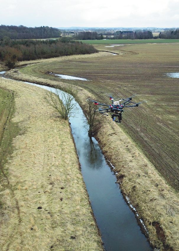
hydrolink 1-2019v3.qxp_25462 22-02-19 13:28 Pagina 11
IAHR
regulated by conveyance control (rating curves). parency causes through-water images and the
Filippo Bandini is a Postdoctoral
These expensive surveys are conducted by ever-changing features on the water surface, researcher at DTU Environment,
human operators and are essential for targeting such as ripples or turbulence, complicate Technical University of Denmark.
river maintenance, i.e. river vegetation cutting identification of homologous points in the His research is currently focused
and riverbed clean-up. Maintenance operations bundle adjustment. For this reason, WSE is on UAS-borne remote sensing
of hydraulic measurements and
are expensive and detrimental to the river generally estimated by identifying points on the
assimilation of these innovative
ecological status, but are necessary to avoid shoreline, i.e. points at the interface between observations into hydrodynamic
floods. land and water, which are supposed to be at models. He is primarily developing, investigating
the same elevation as the nearby water surface and integrating lightweight and accurate sensors to
Thus, recurring questions among researchers away from the shoreline. However, this retrieve water level, speed, and bathymetry
measurements from UAS.
and practitioners working with Danish streams technique requires the operator to survey
are “How can we improve the monitoring system Ground Control Points (GCPs) and necessitates Beat Lüthi studied Mechanical
for optimizing river maintenance and flood high computational time to process images. Engineering at ETH Zürich and
prediction? Can we deploy a technology to Furthermore, when the shoreline method is graduated at ETH in 2002 in the
retrieve hydraulic observations of inland surface applied, the operator has to identify the field of fluid turbulence. Until
2012, Beat Lüthi was leading the
water bodies, whenever and wherever it is shoreline points either manually or through
hyromechanics group at IfU ETH,
required, with (i) high accuracy, (ii) high spatial automatic edge detection algorithms, which is specialized in the fields of image
resolution and (iii) at a reasonable cost?”. highly complicated in densely vegetated rivers. based particle tracking veloci-
Unmanned Aerial Systems (UASs), a new kit in In earlier publications [7]–[9] we presented the metry and turbulence small scale dynamics. In 2012
surveyors’ toolbox, have changed our way to first studies on UAS radar altimetry. Studies Beat Lüthi founded the ETH spin off company photrack
Ltd. Photrack has developed the now patented techno-
“access” and monitor the environment. Indeed, were conducted to measure water surface
logy SSIV to measure surface flow velocities and di-
UAS can monitor remote areas delivering real elevation in Danish rivers and lakes, and in the scharge rates with cameras. For the resulting products
time data. Compared to satellite monitoring, famous and unique cenotes and lagoons of the DischargeKeeper and the Discharge App there is growing
they ensure high spatial resolution, repeatability Yucatan peninsula, Mexico. An accuracy of few business in Europe, USA, Africa, Central Asia and China.
of the flight missions and good tracking of the centimetres and a spatial resolution of few
Peter Bauer-Gottwein is
water bodies. Compared to manned aircrafts, decimetres were achieved. This accuracy and
professor in hydrology and water
UASs are low-cost and easy-to-manoeuvre spatial resolution are higher than any other resources management at DTU
platforms that can retrieve observations with spaceborne radar or airborne LIDAR altimeter. Environment. Research focus
higher temporal resolution, potentially including Furthermore, compared to photogrammetry, areas are hydrological modelling,
periods of hydrological interest, such as floods this technique does not rely on any GCP, and hydrogeophysics, earth
observation for inland water
and droughts. Figure 1 shows a picture of a requires a significantly smaller amount of survey
applications and hydroeconomic
UAS flying above a Danish stream to retrieve time and post-processing computational time modelling. Scientific highlights include ground-breaking
hydrometric observations. Nevertheless, UASs (approximately 1/1000 of processing time). work on the integration of time-lapse gravity
face several constraints: vibrations, limited size, Unlike photogrammetry, UAS radar altimetry observations with hydrological models; Exploration and
weight, and electric power available for the can also measure WSE in rivers surrounded modelling of the world’s largest karstic groundwater
aquifer on the Yucatán Peninsula, México; Assimilation
sensors and inability to fly in extreme weather and overhung by aquatic vegetation and trees.
of satellite radar altimetry observations to hydrologic
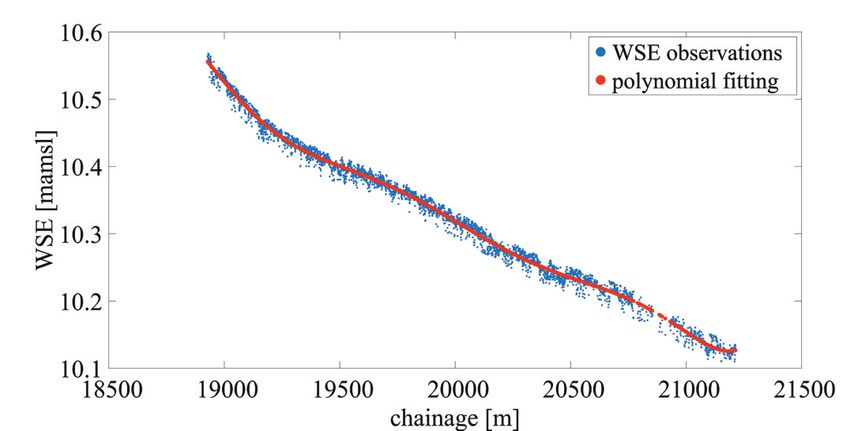
conditions. In Figure 2, we show a WSE profile retrieved forecasting systems; Integration of water and power
with our UAS radar altimetry technique of the system models for joint resource management. He has
Several previous studies have used stretch of a Danish stream. significant international experience, including Southern
photogrammetry to estimate Water Surface Africa, Mexico, China, Central Asia. He has authored
70+ scientific articles in international journals indexed
Elevation (WSE), i.e. height of water surface Surface flow velocity can be estimated with
in ISI Web of Sciences and 4 book chapters.
above mean sea level [3]–[6]. However, there are nonintrusive image analysis techniques applied
a number of serious limitations: water trans- to frames retrieved from the UAS-borne RGB
Figure 2. WSE profile measured for a stretch of Vejle Å (Jutland, Denmark). Left panel shows UAS-borne WSE observations (blue dots) and the profile fitting of
these observations (red line). Right panel shows the 2-km stretch where WSE observations (blue dots) were retrieved, with white labels showing the progressive
river chainage
hydrolink number 1/2019 11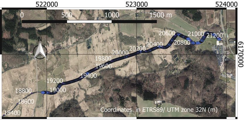
hydrolink 1-2019v3.qxp_25462 22-02-19 13:28 Pagina 12
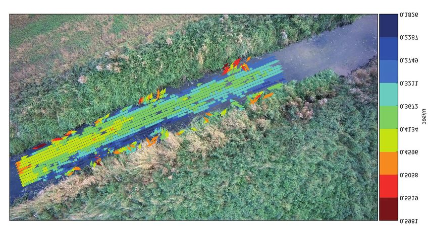
camera. These image techniques commonly Figure 3. Water surface velocity field observations in Værebro å (Denmark)
require that tracer particles are on the water
surface and that they travel with the same
velocity as the surface flow. Surface flow
velocities are reconstructed by determining the
displacements of the tracer particles (such as
leaves, foam, artificial particles) between two
subsequent frames. These image analysis
techniques are generally differentiated between
two categories, based on the Eulerian or
Lagrangian specification of the flow field:
Particle Image Velocimetry (PIV) [10]–[12] or
Particle Tracking Velocimetry (PTV) [13] [14],
respectively. Surface Structure Image
Velocimetry (SSIV) [15], [16] is a special variant of
the PIV cross-correlation technique and is aimed
at reducing the negative influence on the obser-
vations caused by i) glare and shadows on the flights will significantly increase UAS potential improving estimates of surface water-groundwater interaction,”
Hydrol. Process., 2017.
water surface, and ii) lack of traceable features for hydrometric monitoring, including river [9] F. Bandini, A. Lopez-Tamayo, G. Merediz-Alonso, D. Olesen, J.
maintenance optimization and flood prediction. n
Jakobsen, S. Wang, M. Garcia, and P. Bauer-Gottwein,
[17]. Figures 3 and 4 show the SSIV estimation “Unmanned aerial vehicle observations of water surface
elevation and bathymetry in the cenotes and lagoons of the
of the surface velocity field and the extracted Yucatan Peninsula, Mexico,” Hydrogeol. J., pp. 1–16, Apr. 2018.
[10] F. Tauro, M. Porfiri, and S. Grimaldi, “Surface flow measure-
surface velocity profile in a Danish stream. In References ments from drones,” J. Hydrol., vol. 540, pp. 240–245, 2016.
[1] F. Tauro, J. Selker, N. Van De Giesen, T. Abrate, R. Uijlenhoet, [11] F. Tauro, M. Porfiri, and S. Grimaldi, “Orienting the camera and
this case, no artificial particles were added on M. Porfiri, S. Manfreda, K. Caylor, T. Moramarco, J. Benveniste, firing lasers to enhance large scale particle image velocimetry
G. Ciraolo, L. Estes, A. Domeneghetti, M. T. Perks, C. Corbari, for streamflow monitoring,” Water Resour. Res., vol. 50, no. 9,
the water surface and the algorithm was able to E. Rabiei, G. Ravazzani, H. Bogena, A. Harfouche, L. Broccai, pp. 7470–7483, 2014.
A. Maltese, A. Wickert, A. Tarpanelli, S. Good, J. M. Lopez [12] M. Jodeau, A. Hauet, A. Paquier, J. Le Coz, and G. Dramais,
reconstruct the water flow by identifying natural Alcala, A. Petroselli, C. Cudennec, T. Blume, R. Hut, and S. “Application and evaluation of LS-PIV technique for the
Grimaldia, “Measurements and observations in the XXI century monitoring of river surface velocities in high flow conditions,”
particles such as foam or ripples generated by (MOXXI): Innovation and multi-disciplinarity to sense the hydro- Flow Meas. Instrum., vol. 19, no. 2, pp. 117–127, 2008.
logical cycle,” Hydrol. Sci. J., vol. 63, no. 2, pp. 169–196, 2018. [13] F. Tauro, R. Piscopia, and S. Grimaldi, “PTV-Stream: A simplified
water turbulence. [2] R. Lawford, A. Strauch, D. Toll, B. Fekete, and D. Cripe, “Earth particle tracking velocimetry framework for stream surface flow
observations for global water security,” Curr. Opin. Environ. monitoring,” Catena, 2019.
Sustain., vol. 5, no. 6, pp. 633–643, 2013. [14] F. Tauro, R. Piscopia, and S. Grimaldi, “Streamflow
[3] P. Leduc, P. Ashmore, and D. Sjogren, “Technical note: Stage Observations From Cameras: Large-Scale Particle Image
Surface velocity observations are essential to and water width measurement of a mountain stream using a Velocimetry or Particle Tracking Velocimetry?,” Water Resour.
simple time-lapse camera,” Hydrol. Earth Syst. Sci., vol. 22, no. Res., 2017.
highlight flow patterns. Furthermore, surface 1, pp. 1–11, 2018. [15] B. Lüthi, T. Philippe, and S. Peña-Haro, “Mobile device app for
[4] E. Ridolfi and P. Manciola, “Water level measurements from small open-channel flow measurement,” in 7th Intl. Congress on
velocity can also be used to estimate discharge drones: A Pilot case study at a dam site,” Water (Switzerland), Env. Modelling and Software, 2014, vol. 1, pp. 283–287.
2018. [16] B. Lüthi, Thomas Philippe, and S. Peña-Haro, “Method and
following standard procedures such as the ISO [5] A. S. Woodget, P. E. Carbonneau, F. Visser, and I. P. Maddock, system for determining the velocity of a moving fluid surface,”
“Quantifying submerged fluvial topography using hyperspatial EP Nr: 3 018 483, 2018.
standard EN ISO 748:2007. To do so it is resolution UAS imagery and structure from motion photogram- [17] J. P. Leitão, S. Peña-Haro, B. Lüthi, A. Scheidegger, and M. Moy
metry,” Earth Surf. Process. Landforms, vol. 40, no. 1, pp. 47– de Vitry, “Urban overland runoff velocity measurement with
necessary to have also the water depth profile, 64, 2015. consumer-grade surveillance cameras and surface structure
[6] H. Pai and S. Tyler, “Re-examining data-intensive surface water image velocimetry,” J. Hydrol., 2018.
which can be measured either with an in-situ models with high-resolution topography derived from [18] G. Mandlburger, M. Pfennigbauer, M. Wieser, U. Riegl, and N.
unmanned aerial system photogrammetry,” Am. Geophys. Pfeifer, “Evaluation Of A Novel Uav-Borne Topo-Bathymetric
bathymetric survey, or with UAS-borne bathy- Union, Fall Meet. 2017, Abstr. #H41D-1463, 2017. Laser Profiler,” ISPRS - Int. Arch. Photogramm. Remote Sens.
[7] F. Bandini, J. Jakobsen, D. Olesen, J. A. Reyna-Gutierrez, and Spat. Inf. Sci., vol. XLI-B1, pp. 933–939, Jun. 2016.
metric observations obtained from state-of-the- P. Bauer-Gottwein, “Measuring water level in rivers and lakes [19] F. Bandini, D. Olesen, J. Jakobsen, C. M. M. Kittel, S. Wang, M.
from lightweight Unmanned Aerial Vehicles,” J. Hydrol., vol. Garcia, and P. Bauer-Gottwein, “Technical note: Bathymetry
art bathymetric LIDARs [18] or UAS-tethered 548, pp. 237–250, 2017. observations of inland water bodies using a tethered single-
beam sonar controlled by an unmanned aerial vehicle,” Hydrol.
[8] F. Bandini, M. Butts, T. V. Jacobsen, and P. Bauer-Gottwein,
sonar [19]. To convert from surface velocity to “Water level observations from unmanned aerial vehicles for Earth Syst. Sci., vol. 22, no. 8, pp. 4165–4181, Aug. 2018.
discharge, we have to adopt assumptions about
the vertical velocity profile in the water column. Figure 4. UAV-borne surface velocity profile compared to in-situ surface velocity probe measurements,
Thus, UAS can supply hydrometric data, such as Værebro å (Denmark)
WSE, bathymetry and discharge, needed to
inform hydrodynamic modelling and river
management. High spatial-resolution WSE
profiles along streams emerge as a new dataset
that can help us understand how rivers are
affected by vegetation growth and optimize river
maintenance, such as vegetation cutting and
riverbed clean-up. In our vision, hydrometric
UAS-observations are essential not only for small
scale management of flood protection/modelling
and river restoration, but also to establish a river
monitoring UAS-network at regional/national
scale. However, this requires that Beyond the
Visual Line Of Sight (BVLOS) fully autonomous
flights are allowed by the regulators. BVLOS
12 hydrolink number 1/2019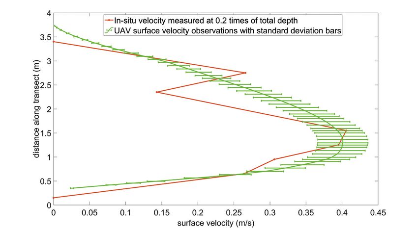
You can also read