West Coast Deep-Sea Coral Initiative Science Plan (2018-2021)
←
→
Page content transcription
If your browser does not render page correctly, please read the page content below
West Coast Deep-Sea Coral Initiative
Science Plan (2018-2021)
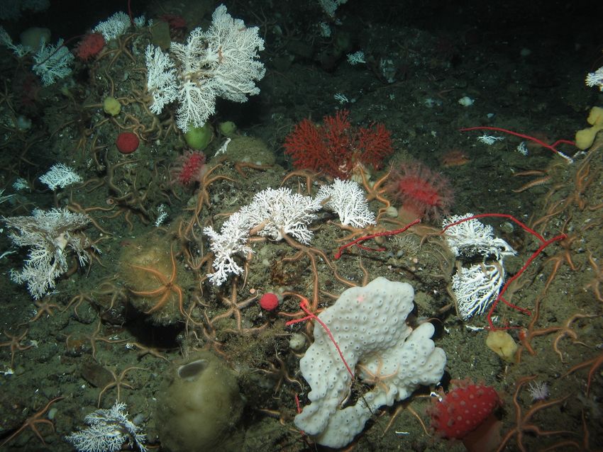
Paragorgia sp. at the “Brush Patch” off Northern California (DSCRTP)
Editors:
Chris Caldow (Co-Chair)
M. Elizabeth Clarke (Co-Chair)
Heather M. Coleman
Elizabeth Duncan
Meredith V. Everett
Tom F. Hourigan
Tom Laidig
Amanda N. Netburn
John H. Stadler
Jenny Waddell
Arliss J. Winship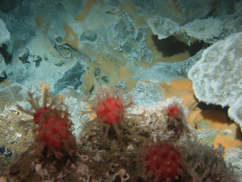
Table of Contents
Introduction ____________________________________________________________________________________________ 3
  NOAA Deep Sea Coral Research and Technology Program: Mission and Objectives 3
  Introduction to the West Coast Deep-Sea Coral Initiative (2018-2021) ______________ 4
     Location and Biogeography of the U.S. West Coast Region ____________________________________________________ 4
     Regional Management of DSCS __________________________________________________________________________________ 4
     Threats to DSCS ___________________________________________________________________________________________________ 7
     Past Research _____________________________________________________________________________________________________ 7
     WCDSCI Structure, Timeline, and Accomplishments to Date __________________________________________________ 8

Thematic Foci __________________________________________________________________________________________ 9
  Summary of Major Place-Based Research Priorities ____________________________________ 10
  Summary of Priorities by Research Topic ________________________________________________ 10
Work Plan to Address WCDSCI Priorities ________________________________________________________ 11
  Initiative Management _______________________________________________________________________ 12
  Funding Uncertainties & Contingencies __________________________________________________ 12
  Field Expeditions _____________________________________________________________________________ 13
     Leveraging Opportunities _______________________________________________________________________________________13
     FY 2018 ___________________________________________________________________________________________________________13
       Cordell Bank, Greater Farallones, and Monterey Bay NMS, NOAA Ship Shimada ________________________13
     FY 2019 ___________________________________________________________________________________________________________14
       EXPRESS DSCS Cruise, NOAA Ship Shimada ________________________________________________________________14
       Olympic Coast NMS, NOAA Ship Shimada ___________________________________________________________________14
       EXPRESS Mapping Cruise, NOAA Ship Rainier ______________________________________________________________14
       Channel Islands NMS, R/V Shearwater ______________________________________________________________________15
     Proposed for FY 2020 ___________________________________________________________________________________________15
       Cordell Bank, Greater Farallones, and Monterey Bay NMS, E/V Nautilus ________________________________15
       EXPRESS DSCS Cruise, NOAA Ship Shimada/Lasker _______________________________________________________16
       Cordell Bank, Greater Farallones, and Monterey Bay NMS, R/V Fulmar _________________________________16
       Channel Islands and Olympic Coast NMS, E/V Nautilus____________________________________________________16

  Video Annotations and Image Analysis of Data __________________________________________ 16
  FY19-FY20 Seafloor Mapping Data Analysis _____________________________________________ 17
  Important Information for WCDSCI Collaborators/Principal Investigators ________ 17
  Products ________________________________________________________________________________________ 18
     Standard DSCRTP Products _____________________________________________________________________________________18
        Observation Records and Site Characterization Reports __________________________________________________18
        Wrap-up Workshop and Final Report _______________________________________________________________________19
     Historical Data Analyses ________________________________________________________________________________________19

                                                                                                                        1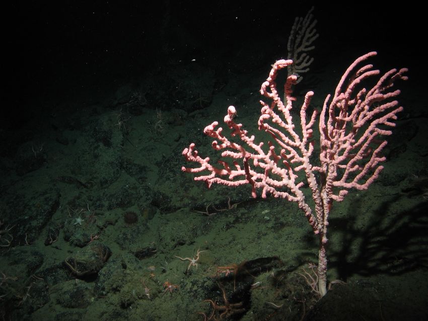
Southern California Bight ROV Dives ________________________________________________________________________19
       Coral and Fish Association Analyses ________________________________________________________________________19
     Genetics, Connectivity, and Taxonomy _________________________________________________________________________21
       Species Identification and DNA Barcoding __________________________________________________________________21
       Population Connectivity Studies _____________________________________________________________________________21
       eDNA Analysis ________________________________________________________________________________________________22
     Modeling__________________________________________________________________________________________________________22
       Modeling Workshop __________________________________________________________________________________________22
       Advancing Predictive Habitat and Distribution Modeling _________________________________________________23
     Collaboration Facilitation Tools ________________________________________________________________________________23
       Spatial Prioritization Tool ____________________________________________________________________________________23
       Target Species List ____________________________________________________________________________________________24
     Species Identification Guide for West Coast Corals, Sponges, and Fishes ___________________________________25
     Outreach and Education Tools and Opportunities ____________________________________________________________25
       Photomosaics to supplement NMS Online Curricula _______________________________________________________25
       SeaSketch Educational Portal ________________________________________________________________________________26
       3D Printed DSCS ______________________________________________________________________________________________26
       Infographics ___________________________________________________________________________________________________26

References _____________________________________________________________________________________________ 29
Appendix A. Thematic Foci __________________________________________________________________________ 32

                                                                                                                       2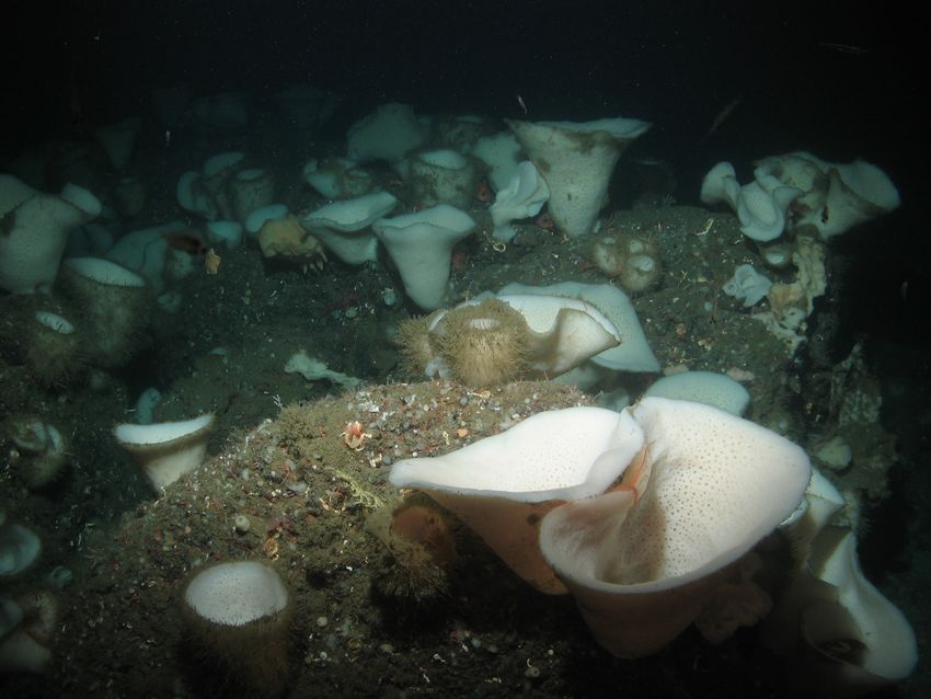
Introduction
         This Science Plan presents the objectives, proposed work-plan, and anticipated outcomes
for the National Oceanic and Atmospheric Administration (NOAA) West Coast Deep-Sea Coral
Initiative (WCDSCI) under the Deep Sea Coral Research and Technology Program (DSCRTP).
The four-year Initiative (FY 2018-2021) is designed to work with partners to discover, map,
characterize, explore, and conduct research on deepwater coral and sponge habitats in support of
natural resource management off California, Oregon and Washington. The Science Plan was
developed by a cross-NOAA steering committee with input from numerous partners and
stakeholders. The Steering Committee will review the plan annually and provide ongoing
guidance on implementation and budget. Out-year activities are subject to federal appropriations.

NOAA Deep Sea Coral Research and Technology Program: Mission and
Objectives
         NOAA established the DSCRTP under the authority of the Magnuson-Stevens Fishery
Conservation and Management Act, as reauthorized in 2007. The goal of DSCRTP is to provide
scientific information needed to manage, conserve, and protect DSCS ecosystems throughout the
United States. These ecosystems create important biogenic habitats and support remarkably
complex communities in deep waters around the globe, including off the U.S. West Coast
(Clarke et al. 2017).
         In carrying out their mission, DSCRTP supports multi-year regional fieldwork initiatives
that produce new research along with analyses of historical data. To-date initiatives have been
carried out in the South Atlantic (2009-2011), West Coast (2010-2012), Alaska (2012-2014),
Northeast (2013-2015), Pacific Islands (2015-2017), and the greater Southeast (2016-2020)
regions. Field work has included mapping, quantitative visual surveys and sample collection
conducted in collaboration with regional fishery management councils, NMS, other federal
agencies, academic partners, industries and non-government organizations (NGO) that collect
and analyze information on DSCS location, biology, ecology, and potential anthropogenic
impacts.
        A national-level data management infrastructure supports these regional initiatives,
allowing DSCRTP-supported data to be accessible by the public. In 2018, DSCRTP initiated the
second regionally-led deep-sea coral research program on the U.S. West Coast, referred to as the
West Coast Deep-Sea Coral Initiative (WCDSCI). WCDSCI’s timeline (2018-2021), goals,
priorities, and accomplishments to-date are described in the sections that follow.

                                                                                                3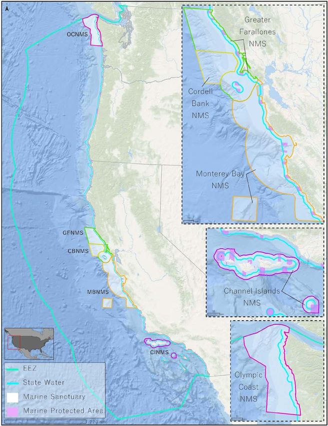
Introduction to the West Coast Deep-Sea Coral Initiative (2018-2021)
Location and Biogeography of the U.S. West Coast Region
        The U.S. Pacific Coast marine region encompasses the continental margin off the coasts of
Washington, Oregon, and California, totaling 778,628 km2 (Figure 1). The continental margin in
this region is characterized by a relatively narrow (5-40 km) shelf and a steep continental slope,
with the shelf break at approximately 200 m water depth. Other bathymetric features present off
the West Coast include offshore islands, seamounts, oil and methane seeps, and submarine
canyons. This marine region is wholly within the California Current Large Marine Ecosystem
and includes two biogeographic provinces: the Oregonian province, which is a cold-temperate
area in the north characterized by the southward flowing California Current, and the warm-
temperate Californian province in the south, which is more heavily influenced by the northward
flowing Davidson Current and Southern California Countercurrent. The two provinces converge
near Point Conception in southern California, marking a major transition zone and biogeographic
break where many species reach their northern or southern range limits. Frequent upwelling
events are also characteristic of both west coast provinces, exposing the coastline to cold,
nutrient rich, low pH, and oxygen depleted water during summer months when upwelling is
strongest. The strength, duration, and timing of upwelling events are highly influenced by El
Niño Southern Oscillations, Pacific Decadal Oscillations, as well as the local bathymetry (Fautin
et al. 2010). The resulting variability in pulses of primary productivity creates a dynamic and
complex marine environment along the West Coast. In recent years, however, typical upwelling
patterns and other oceanographic processes have been disrupted, coincident with extreme
weather events (e.g., marine heat waves and extended hypoxic events) with observed anomalies
from the sea surface to at least 200 m in depth (Grantham et al. 2004; Harvey et al. 2017).
Consequences of these anomalies are better understood for marine life such as marine mammals
and fishery species than for marine life inhabiting the deep seafloor.

Regional Management of DSCS
        To date, physical disturbance from bottom-tending fishing gear has been one of the
largest chronic threats to DSCS. The Pacific Fishery Management Council (PFMC) and NOAA
have been protecting DSCS, both directly and indirectly, through groundfish fishery
management measures. DSCS are among the habitat types that benefit from the network of
essential fish habitat conservation areas (EFHCAs) that prohibit bottom trawling and, in some
cases, other types of fishing gear in contact with the seafloor. The EFHCA network presently
contains 10,225 km2 of hard and mixed substrate, including areas where DSCS are known to
occur.
DSCS and other benthic habitats are also indirectly protected by bottom-trawl closures designed
to minimize bycatch of overfished species, such as trawl rockfish conservation areas (RCAs)

                                                                                                  4
Figure 1: Map of the U.S. West Coast, the study area of the regional DSCRTP supported
initiative.
5and cowcod conservation areas (CCAs). The RCA is a large-scale closed area extending along
the entire length of the U.S. West Coast, covering 13,071 km2. The RCA contains approximately
1,079 km2 of hard and mixed substrate that includes numerous observations of DSCS. The two
CCAs cover 13,315 km2, and contain 995 km2 of hard and mixed substrate, also with numerous
observations of DSCS.
How much DSCS habitat resides within the bottom-trawl closed areas is not clear based
on the general lack of high resolution mapping and visual survey data in the region. However,
the different types of fishery management closures, some of which overlap, cover approximately
375,000 km2.
Most recently, Amendment 28 to the Groundfish Fishery Management Plan (FMP) was
approved by the PFMC in April 2018, and when implemented, will modify the suite of EFHCAs
and eliminate (i.e., reopen to bottom-contact fishing) the trawl RCA off Oregon and California.
No changes were proposed for federal waters off Washington State as part of Amendment 28.
This PFMC action was informed by data in NOAA’s National Database of Deep-Sea Corals and
Sponges (current version 20190418-0; Hourigan et al. 2015) as well as input from the fishing
industry. New essential fish habitat closures will cover approximately 33,670 km2, and
approximately 7,770 km2 will be reopened to bottom trawling. Approximately 228 km2 of hard
substrate will be reopened to trawling, while another 2,033 km2 of hard substrate will be closed
to bottom trawling. The areas that will be reopened have been closed to bottom trawling for the
past 12-16 years and present a unique opportunity to study the recovery potential of DSCS.
Amendment 28 will also close all waters deeper than 3,500 m to bottom-contact gear. Although
comprehensive substrate data are unavailable for this large area of the U.S. exclusive economic
zone, numerous observations of DSCS have been recorded throughout.
In addition to protections that accrue from the fisheries management processes described
above, NOAA has also provided protections to DSCS through establishment and management of
five national marine sanctuaries (NMS) on the West Coast. West coast sanctuaries afford
protections for more than 38,850 km2 of seafloor habitats and communities encompassed by
sanctuary boundaries, each of which includes DSCS habitat: Channel Islands NMS (CINMS),
Monterey Bay NMS (MBNMS), Greater Farallones NMS (GFNMS), Cordell Bank NMS
(CBNMS), and Olympic Coast NMS (OCNMS). Although NMS do not regulate fishing
activities, sanctuary regulations prohibit alteration of submerged lands and other types of human
uses that could potentially harm DSCS habitat, such as oil and gas exploration/extraction, and
permit others that may break sanctuary regulations but contribute to research, monitoring, and
management of sanctuary resources. Each of the five sanctuaries are guided by specific
management plans tailored to address site-specific issues, and each brings unique perspectives to
seafloor and DSCS protection efforts. Generally, resource protection specialists across sites
focus on mitigating impacts to the seafloor from marine accidents and groundings, anchoring,
marine debris, and research activities through permitting processes. Some California national
marine sanctuaries are also heavily engaged in addressing concerns related to bottom-contact
fishing activities, and staff at these sites regularly collaborate with fishers, conservationists,
6managers, and other interested parties through the formal processes of the PFMC. Some sites
also have special management zones within their boundaries to further protect particularly
sensitive DSCS habitat.
Over time, the reach of national marine sanctuary protections has increased through
boundary modifications. For example, in November 2008, the boundaries of MBNMS were
expanded by 2,007 km2 to include Davidson Seamount, one of the largest known seamounts in
U.S. waters that was found to harbor hundreds of species of deep ocean organisms (including
many DSCS) and several species new to science. In 2015, the boundaries of both GFNMS and
CBNMS were expanded by 3,320 km2 and 1,370 km2, respectively. Expansion areas include
significant portions of the continental shelf and a number of submarine canyons that are highly
likely to include significant DSCS living resources.
Threats to DSCS
Current and ongoing threats to DSCS along the U.S. West Coast generally stem from
human activities that may have direct or indirect impacts to deep-sea habitat. Direct threats
include seafloor disturbances that stem from activities such as fishing using bottom-contact gear,
anchoring or mooring, marine accidents, groundings or other emergencies, installation of
submarine telecommunication cables, as well as research that may disturb sensitive areas of the
seafloor. The potential for new offshore industries in support of the nation’s blue economy, such
as aquaculture, renewable energy, or mining, represent important economic opportunities that
will require baseline data to inform management and mitigation of potential impacts to these
ecosystems. Indirect threats include human activities that induce changes in climate and in ocean
conditions, such as ocean acidification, hypoxia, and temperature anomalies like marine heat
waves. These indirect issues are assumed to continue to disrupt ocean conditions, particularly in
the northern extent of this geography. For a more thorough discussion of potential threats to
DSCS on the West Coast, see Clarke et al. (2017).
Past Research
The first coordinated campaign to study deep-sea corals on the U.S. West Coast was
initiated in 2010 with the support of DSCRTP. Priorities for the 2010 initiative were defined in a
workshop similar to the one described below (Caldow et al. 2019). The goals of the first
Initiative were to determine the distribution and abundance of DSCS along the West Coast; to
collect, identify, and describe unknown species of DSCS; and to examine the relationship
between fish and DSCS to better understand whether DSCS act as essential fish habitat (EFH).
Over 100 annotated visual surveys for coral, sponges, and habitat type were conducted along the
entire West Coast as part of these efforts. More than 50% of these sites were previously
unexplored. These data have been used by the PFMC during EFH decision-making processes,
and have informed sanctuary boundary expansion analyses and sanctuary condition reports.
Thousands of data records have been submitted to the National Database and are being used to
7model habitat suitability for DSCS by the Bureau of Ocean Energy Management (BOEM) and
NOAA. These data have also enabled new analyses related to understanding anthropogenic and
environmental disturbances on coral and sponge assemblages (Yoklavich et al. 2018) and on
octocoral reproduction (Feehan and Waller 2015). In addition, many specimens of DSCS and
associated organisms were collected to confirm taxonomic identifications and for genetic,
reproductive, and stable isotope analyses. This work also resulted in several new species
descriptions.
WCDSCI Structure, Timeline, and Accomplishments to Date
The second regionally-led deep-sea coral research initiative on the West Coast supports
DSCS research, conservation, and management for 4 years, starting in fiscal year (FY) 2018.
Year 1 (2018) served as a ramp-up year to accommodate preparation and planning for the
following field-intensive years (2019-2020) when the majority of research expeditions will
occur. The last year (2021) will serve as a wrap-up year to conclude outstanding tasks, such as
submitting data records to the National Database or finalizing manuscripts for publication.
During the 2018 ramp-up year, WCDSCI co-leads Elizabeth Clarke (Northwest Fisheries
Science Center, or NWFSC) and Chris Caldow (CINMS) formed a NOAA-led steering
committee with representatives from the National Marine Fisheries Service (NMFS), Office of
National Marine Sanctuaries (ONMS), National Centers for Coastal Ocean Science (NCCOS),
Office of Exploration and Research (OER), and DSCRTP. Following the formation of a steering
committee, CINMS and NMFS organized and hosted a priority scoping workshop that captured a
wide variety of perspectives from regional experts on the most pressing research and
management needs relevant to the West Coast. The results from this Research Priorities
Workshop (Caldow et al. 2019), which are outlined below, have heavily shaped the science
priorities and activities outlined in this Plan. In addition to drafting the workshop report and
beginning to prepare the Science Plan in 2018, WCDSCI also supported two DSCS cruises that
visited many of the priority areas identified during the Research Priorities Workshop, thereby
taking advantage of early opportunities to collect DSCS data and address critical management
needs.
8A sponge garden on Daisy Bank off the coast of Oregon (DSCRTP)
Thematic Foci
The Research Priorities Workshop held in April 2018 was instrumental in establishing the
overarching science and management priorities that will guide WCDSCI activities over the next
several years. In total, 41 experts from NOAA (NWFSC, Southwest Fisheries Science Center or
SWFSC, Alaska Fisheries Science Center or AFSC, NMFS West Coast Regional Office, ONMS,
NCCOS, and OER), PFMC, BOEM, U.S. Geological Survey (USGS), Fisheries and Oceans
Canada (DFO), Ocean Exploration Trust (OET), Quileute Tribe, Makah Tribe, Northwest Indian
Fisheries Commission, academic institutions, and NGOs participated in group sessions to
identify deep-sea coral survey and product related priorities along the West Coast. Attendees
were divided into small groups focused on the following topics: (1) mapping; (2) visual surveys
and research questions; (3) modeling; (4) species identification, genetics, and connectivity; (5)
human impacts; and (6) education and outreach products. Detailed recommendations on each of
these themes are in Appendix A, but a brief summary is given here in the following sections. The
activities outlined in this Science Plan were developed by the WCDSCI Steering Committee
9based on the recommendations from the Research Priorities Workshop, their feasibility,
intersection with NOAA goals, and were prioritized based on available funding.
Summary of Major Place-Based Research Priorities
Overall, three major themes emerged from the Research Priorities Workshop discussions,
each directly or indirectly tied to geographic locations. An emphasis was put on the following:
1. Gather baseline information from areas subject to fishing regulation changes prior to
the implementation of Amendment 28 to the Pacific Coast Groundfish Fishery
Management Plan.
2. Improve our understanding of known DSCS bycatch “hot spots”.
3. Explore and assess DSCS resources within NOAA National Marine Sanctuaries with
emphasis on areas of sanctuary resource protection and management concerns
Summary of Priorities by Research Topic
Critical management issues, research questions, prioritized geographic locations, and
outreach materials that were identified as priorities are described in more detail in Appendix A.
In brief, potential priority areas were identified for the collection of multibeam bathymetry data,
which are necessary to determine if an area is likely to support DSCS communities and
important to safely plan remotely operated vehicle (ROV) or autonomous underwater vehicle
(AUV) surveys (Appendix A.1). Participants also made a series of recommendations to improve
and optimize the use of visual surveys to evaluate abundance, distribution, genetics, habitat
associations, disturbances from human activities, and other key aspects of DSCS communities
(Appendix A.2). Research priorities for predictive habitat modeling include incorporating
important predictor variables and advancing innovative methodologies (Appendix A.3). Genetic
research informs identification and connectivity studies and should be included in ongoing DSCS
work on the West Coast. A preliminary list of target species for connectivity studies was
compiled at the Research Priorities Workshop (Appendix A.4). DSCS are not immune to human
impacts and careful consideration should be made to study effects of warming, acidification,
deoxygenation, bycatch, and other impacts on DSCS communities, particularly through long-
term monitoring and comparative approaches (Appendix A.5). Finally, participants brainstormed
a range of ideas to share the work of WCDSCI with the public including lesson plans, story
maps, museum partnerships, and the use of social media (Appendix A.6). Ultimately, the priority
projects and products included in the WCDSCI Science Plan represent a subset of the many
suggested by workshop participants. For a comprehensive overview of the Research Priorities
Workshop, see Caldow et al. 2019.
10Mushroom Corals (Heteropolypus ritteri) near a methane seep off Northern California (DSCRTP)
Work Plan to Address WCDSCI Priorities
The initiative will strive to collect information that addresses the shared priorities of
agencies involved in the management of DSCS ecosystems on the West Coast, namely PFMC,
NMFS, the five NMS, and four Coastal Treaty Tribes living on Washington State’s Olympic
Coast, and these organizations will be consulted regularly throughout the 4-year initiative. The
main activities planned are described in the following sections. Whenever possible, WCDSCI
will strive to address additional research and management needs described in the Research
Priorities Workshop report, either through partnerships or potential leveraging opportunities.
To address the above goals, the planned activities supported by DSCRTP are outlined
below, and mainly consist of (1) field expeditions on NOAA research ships and sanctuary
vessels to collect visual survey, mapping and environmental data in fished and unfished areas,
(2) the analysis of newly gathered information as well as historic data, (3) the advancement of
predictive modeling efforts, (4) the continuation and advancement of genetic and taxonomic
analyses, and (5) the development of both data and education/outreach products. A summary of
planned field expeditions is provided in Table 1, while planned data and outreach products are
detailed in Table 2.
11Initiative Management
The WCDSCI management team is divided into four parts: DSCRTP, initiative leads,
coordinators, and the Steering Committee. Representation from NOAA DSCRTP ensures that
the initiative stays on target with national goals and objectives, is responsive to program
mandates as well as to Congress, and (together with the West Coast Regional Office) is inclusive
of PFMC and other relevant fishery management efforts. Second, initiative leadership is divided
between NWFSC and ONMS. The co-leads are responsible for raising funding and awareness to
support the initiative, building partnerships, ensuring effective and efficient use of resources, and
ensuring products developed are on target with regional and national needs. The co-leads are also
responsible for the selection of the next two management components (coordinators and the
Steering Committee). The coordinators work to enhance connectivity across other regional
initiatives as well as with headquarters. They lead project information gathering, workshop
planning, Science Plan development, and report writing, as well as assist with vessel time
requests, sample processing, and outreach. The Steering Committee is chiefly responsible for
leading research priority and wrap-up workshops, writing the Science Plan, and making
budgetary recommendations. In addition, each member of the Steering Committee is responsible
for coordinating within their home office, channeling broader input, and identifying
opportunities for partnership and leverage.
Funding Uncertainties & Contingencies
The Science Plan serves as a framework for additional study of these important deep-sea
habitats. NOAA’s DSCRTP strongly encourages identifying other potentially significant
leveraging opportunities not listed below that may be achieved through additional partnerships or
collaborations. Some activities are also contingent on the award of future ship time on NOAA
research vessels, which is presently uncertain but has been estimated here based on past
experience. Given that future ship time is unknown and that multiple proposals were submitted
across NOAA offices to increase the likelihood of acquiring days at sea (DAS) to support
WCDSCI research, it is possible that more ship time may awarded to WCDSCI collaborators or
principal investigators (PI) than the budget can support. In this case, the Steering Committee will
discuss the available options and choose to support the highest priority field missions. In the
event that additional resources become available or anticipated ship time is not provided by
NOAA, funds may be reallocated to other priority efforts vetted by the Steering Committee. This
Plan is the result of an effort to balance new data acquisition and the analysis of historic data,
however, there are more historic data sets than the balanced budget could support. Therefore, the
list of prioritized contingency projects is mainly comprised of these historical data sets which
will be considered first for funding should resources become available (see Table 3 for a list of
the west coast data rescue needs).
12Field Expeditions
Research expeditions will occur primarily on NOAA and NOAA-partner (e.g., E/V
Nautilus) research ships and smaller sanctuary vessels. Research cruises planned with
confirmed/awarded ship time are detailed below and summarized in Table 1. However, since
ship time has yet to be awarded for FY 2020, cruises proposed for the second year of field
activities are tentative and represent the best possible estimate of potential DAS on multiple
vessels. Depending on the availability of vessels and staff, the following activities may occur
during field missions: seafloor mapping, visual surveys via ROV and/or AUV, specimen
sampling and preservation, and collection of supplemental environmental information. Also,
whenever possible, field expeditions will be enhanced with small projects and experiments to
address additional research priorities highlighted during the Research Priorities Workshop.
Leveraging Opportunities
Seeking common goals with other agencies within and external to NOAA can be an
efficient way to address shared research priorities, integrate expertise and technology, and
accomplish more than agencies acting independently. One example of an inter-agency
collaboration in which WCDSCI is engaged is the EXpanding Pacific Research and Exploration
of Submerged Systems (EXPRESS) campaign. The EXPRESS campaign targets data collection
in deep water areas off California, Oregon, and Washington and seeks to expand collaboration
among federal entities such as BOEM, USGS, the Office of Coast Survey (OCS), OER, NMFS,
OET, and ONMS. The main goal of the campaign is to align resources and efforts to generate
geospatially explicit habitat information in deep water ecosystems to support resource
management decisions while also supporting the U.S. government’s mission of growing
commerce. Coordinated efforts to acquire ship time under the EXPRESS campaign were
successful in 2019 and will be employed again for ship time in 2020 to address mutual deep-sea
related research priorities. Another active collaboration that addresses deep-sea research needs is
the partnership between OER, OET, and ONMS. OET’s exploration vessel (E/V) Nautilus has
explored each of the five west coast NMS on previous missions as well as other deep-sea areas
from Mexico to Canada. The Nautilus is equipped with sophisticated mapping instrumentation, a
set of paired deep-sea (>1000 m) ROVs, and a telepresence communication system that allows
scientists from across the world to contribute to the mission in real time. In 2019, the Nautilus
will be working within three west coast NMS, through grant funds administered by ONMS,
conducting work that directly complements WCDSCI science and outreach goals.
FY 2018
Cordell Bank, Greater Farallones, and Monterey Bay NMS, NOAA Ship Shimada
Although the initiative did not request ship time in 2018, the Steering Committee did commit
funds to help support a DSCS cruise on the NOAA Ship Bell M. Shimada (Shimada) in August
132018 for 12 DAS. The Shimada conducted visual surveys in CBNMS, GFNMS, and MBNMS
with an ROV funded in part by the WCDSCI. The data will be analyzed for deep-sea coral and
sponge presence, absence, and abundance as well as for fish size and abundance.
FY 2019
EXPRESS DSCS Cruise, NOAA Ship Shimada
As part of the EXPRESS campaign, SWFSC, NWFSC, and ONMS were each awarded 10 DAS
aboard NOAA Ship Shimada, together providing 30 DAS to support DSCS research. The sea
days were combined into a single expedition that was jointly planned by NOAA, BOEM, and
USGS and occurred October 9 - November 8, 2018. During the cruise, 15 sites were studied in
offshore waters from Newport, Oregon to San Diego, California. Thirty-seven ROV dives,
including 150 timed transects, and 24 AUV dives were completed. The majority of the dives
were conducted in previously unexplored sites. Geological, biological, and water chemistry
samples were collected, and specific sites for model validation were also visited. Forty-one coral
samples and 54 sponge samples were collected for genetic and taxonomic identification and
isotope analysis. Water chemistry samples were collected for vertical profiles of nutrients
(n=104), major/minor elements (n=104), water isotopes (n=87), alkalinity (n=91), pH (n=91),
and dissolved inorganic carbon (n=49). These measurements will provide a spatial gradient of
water column properties that influence DSCS habitat, including nutrient availability and
aragonite saturation state. Twenty-seven of the water chemistry samples were collected near
corals to enable environmental DNA analysis.
Olympic Coast NMS, NOAA Ship Shimada
OCNMS was awarded 7 DAS by the NOAA Fleet Council to support a research cruise to
investigate DSCS communities within the sanctuary in September 2019. Because PFMC
Amendment 28 does not open, close, or otherwise alter any EFH or RCA that fall within the
sanctuary (due to overlap of the sanctuary with the treaty-protected fishing areas of Washington
State’s four Coastal Treaty Tribes), that thematic focus area, which is of great interest elsewhere
in the region, does not apply to this sanctuary. Thus, further characterization of sensitive hard
bottom habitats, including within the existing Olympic 2 EFH area, is expected to be a primary
goal of the expedition. A detailed cruise plan will be developed in cooperation with WCDSCI
Steering Committee members to achieve the broader goals of the initiative while addressing
specific OCNMS concerns.
EXPRESS Mapping Cruise, NOAA Ship Rainier
Building on the momentum and progress generated to date by the collaborative, multi-agency
EXPRESS campaign, collaborators are again hoping to secure 15 additional DAS of NOAA Ship
time on NOAA Ship Rainier in summer 2019 to conduct targeted high-resolution mapping of
14deep water (>50 m) seafloor areas that may harbor significant living marine resources including
DSCS species. A formal process is underway for identifying geographic priorities for seafloor
mapping and establishing consensus on those priorities. Results will guide mapping efforts
undertaken through the EXPRESS campaign and provide opportunities for further engagement,
consistent with each agency’s unique mission and capabilities.
Channel Islands NMS, R/V Shearwater
In FY 2019, a seven-day mission aboard the research vessel (R/V) Shearwater will focus on
surveying uncharacterized regions within CINMS. High resolution seafloor mapping data
collected in CINMS since 2014 has led to the identification of several unexplored yet unique and
potentially biologically significant features. As a result, this cruise will focus on: 1)
characterizing newly identified seafloor features, and 2) exploring areas near San Miguel Island
that cross the biogeographic transition zone into cooler waters. A third objective will be to revisit
the Footprint Marine Reserve, an area of particularly high coral cover known to harbor an
abundance of fish. A detailed cruise plan will be developed in cooperation with WCDSCI
Steering Committee members to achieve the broader goals of the initiative while addressing
specific CINMS management priorities.
Proposed for FY 2020
Cordell Bank, Greater Farallones, and Monterey Bay NMS, E/V Nautilus
For more than a decade, NOAA OER has supported OET operations, and other NOAA programs
have additionally developed productive and collaborative relationships with them. OET’s
exploration vessel, E/V Nautilus, has been an important asset for exploring deep seafloor areas of
west coast NMS over the past few years, and provides an opportunity for scientists ashore to
participate in real-time. In 2019, OET was awarded approximately $2 million through a major
ONMS funding opportunity to explore and document the deep-sea oceanography, marine
habitats, cultural sites, and living and non-living resources in and around NMS while using
telepresence to engage the general public as well as formal and informal educators. With this
support, cruises are expected to occur in west coast sanctuaries throughout the duration of the
WCDSCI. These expeditions will enhance DSCS research by providing additional opportunities
for fieldwork, ROV visual surveys, and public outreach via the ship’s telepresence system. In
early FY 2020 (October 2019), the Nautilus expedition season is expected to include
approximately 17 days of mapping and visual survey work in CBNMS and GFNMS in central
California. Due to significant technical difficulties experienced during an expedition to MBNMS
at the end of the 2018 expedition schedule (early FY 2019), OET has expressed an intention to
allocate additional DAS to MBNMS as part of the FY 2020 (October 2019) expedition.
15EXPRESS DSCS Cruise, NOAA Ship Shimada/Lasker
In October 2019 (early FY 2020), WCDSCI will support an expedition of up to 30 DAS along
the U.S. West Coast aboard either NOAA Ship Shimada or Reuben Lasker (Lasker). The cruise
will be a collaborative effort among researchers from NMFS (NWFSC and SWFSC), ONMS,
OER, USGS, and BOEM, and conducted as part of the EXPRESS campaign. The main focus of
this FY 2020 expedition will be to conduct quantitative visual surveys of DSCS and fishes using
an AUV and ROV, with an emphasis on characterizing previously-unexplored areas through
collection of new baseline data; revisiting previously surveyed sites; collecting samples for
species validation, identification, and connectivity studies; groundtruthing DSCS habitat
suitability model outputs; and mapping high-value portions of the seafloor. Although specific
survey locations have not been selected, the majority of work is expected to happen within
Amendment 28 modification areas that were not surveyed in FY 2019, areas of priority to
EXPRESS collaborators including USGS and BOEM, and/or high coral bycatch, areas of interest
identified from the Spatial Prioritization Tool (see Collaboration Facilitation Tools), and sites
within NMS boundaries.
Cordell Bank, Greater Farallones, and Monterey Bay NMS, R/V Fulmar
Initiative funds have been allocated in FY 2020 for approximately 7 days of ROV surveys using
the sanctuary vessel, R/V Fulmar, to benefit one or more of the central California NMS:
MBNMS, GFNMS, and CBNMS. Allocation of support for work on the R/V Fulmar is to be
determined and will be used to try to balance the overall portfolio of fieldwork activities and
ensure that all west coast NMS sites have the chance to conduct new surveys and collect new
data in FY 2019 and FY 2020.
Channel Islands and Olympic Coast NMS, E/V Nautilus
Through the same competitive ONMS telepresence grant awarded to OET, OET will continue to
partner with NMS in FY 2020 and is anticipating to conduct additional mapping and ROV visual
survey efforts from the E/V Nautilus. Primary activities are expected to occur in OCNMS and
CINMS, and may include modest effort within MBNMS.
Video Annotations and Image Analysis of Data
DSCS and fish data will be collected from the video and still imagery recorded from each cruise.
For consistency, all video and image annotation from all cruises will be completed by experts
using similar methodology. Video annotators will consult on difficult to identify species. Images
will be annotated by NOAA (NWFSC, SWFSC, NMS, NCCOS) and contracted experts (with
guidance from NOAA experts) in DSCS and fish identification and image analysis. The general
plan for image analysis is to identify and enumerate all DSCS and fishes observed during
transect times. All DSCS 10 cm and larger in height will be measured (when possible) using
16either stereo camera imaging software or scaling laser spots visible in the video or still image
(these spots are 10-20 cm wide depending on the survey vehicle used). All fishes will be
identified to the lowest practical level of taxonomic resolution and their total length measured
(for fishes 10 cm and greater). Seafloor habitat classification will be completed for all transects.
Once the data are collected and checked for accuracy, DSCS observation records will be
uploaded to the National Database. Additional analyses may be conducted for individual data
sets (e.g., the FY19 R/V Shearwater cruise) in order to add value to the data and answer other
key research questions.
FY19-FY20 Seafloor Mapping Data Analysis
Multibeam bathymetry and associated backscatter data will be collected throughout the study
region as part of the WCDSCI as well as the associated EXPRESS campaign. These new data
acquisitions will be compiled together with readily accessible pre-existing data sets originating
from partners including: NOAA, USGS, Oregon State University, California State Monterey Bay
and Fugro. Footprints of each data set along with metadata will be uploaded to the NOAA Office
of Coast Survey Integrated Ocean and Coastal Mapping Program’s Seasketch website at the
University of California, Santa Barbara. Metadata will include year of acquisition, horizontal
resolution, presence of associated backscatter, and contact information for the data. Datasets
collected will be integrated into coastwide products that can then be utilized for site selection and
species distribution modeling.
Important Information for WCDSCI Collaborators/Principal
Investigators
It is crucial to note that any field mission supported (in full or part) by WCDSCI is done
so with the expectation and understanding that the cruise-lead or chief scientist will ensure that
the required data products are budgeted for and contributed to the DSCRTP’s National Database,
with the type of products dependent upon the level of support. The data team, Matt Dornback
(matt.dornback@noaa.gov) and Robert McGuinn (robert.mcguinn@noaa.gov), will connect with
cruise-leads in advance of the field work, during cruise planning, to provide guidance and
facilitate the collection of data. The data team will also offer guidance post-cruise to facilitate
database submissions. Documentation detailing data requirements is also available online (i.e.
Fieldwork Data and Reporting Guidance, Checklist and Timeline for Science Team Data
Deliverables).
17Octocorals, hydrocorals and sponges on Mendocino Ridge, CA (DSCRTP)
Products
Standard DSCRTP Products
Observation Records and Site Characterization Reports
PIs funded through WCDSCI are required to submit standard products to DSCRTP,
including georeferenced location and species records for DSCS and a site characterization
summarizing DSCS and fish resources within a location. To facilitate and streamline the
development and submission of standard products, PIs will be connected with DSCRTP data
team staff during cruise planning in an effort to streamline data collection, records formatting,
and submission of DSCS observations to the National Database online portal. Where possible,
ancillary observations, such as fish-habitat associations, assessments of DSCS health or
condition, and measurement of physical/chemical properties of the ocean will be summarized
and reported to DSCRTP.
18Wrap-up Workshop and Final Report
A wrap-up workshop will be organized in the final year of WCDSCI (FY 2021). This
workshop will allow WCDSCI participants to reflect on the successes and challenges of the
initiative, report on the status of outstanding tasks or database submissions, and summarize
initiative accomplishments. A final report will be submitted to DSCRTP.
Historical Data Analyses
Mining or ‘rescuing’ previously collected survey datasets through retrospective image
and video analysis can provide enhanced DSCS occurrence data (i.e., presence/absence,
quantitative measures of area surveyed, and coral number, condition, and size). The following
projects involve analyzing data sets collected in years previous to the WCDSCI.
Southern California Bight ROV Dives
NOAA NCCOS will conduct a retrospective video analysis of select surveys previously
conducted in the Southern California Bight. Analysis will focus on benthic characterization of
hard and soft bottom areas 50-350 m deep within CINMS, with special attention to quantification
of coral and sponge densities and identification of coral gardens. The analysis will produce a
large number of new high-quality observation records and information (e.g., presence/absence,
abundance, condition, colony size) for the National Database. The image analysis will focus on
surveys conducted since 2015 by OET, NCCOS, ONMS, and Marine Applied Research and
Exploration (MARE). The new data will also support the development of enhanced habitat
suitability models (see Modeling section).
Coral and Fish Association Analyses
Studies on fish associations with DSCS have demonstrated mixed results. Studies off
Alaska (Krieger and Wing 2002; Stone 2006) found high numbers of fish associating with corals
and sponges, while studies in other areas found many fewer fish (Tissot et al. 2006; Yoklavich et
al. 2013). The goal of this FY 2020 project is to investigate the corals as habitat for groundfishes
along the West Coast using existing data sets, primarily an extensive, long-term manned
submersible and ROV data set collected in southern and central California. These data were
collected over 19 years (1992-2011) by SWFSC scientists using a variety of survey vehicles
(Delta submersible, DeepWorker and Dual DeepWorker submersibles, SWFSC Phantom ROV,
and the Kraken II ROV). Fish densities, lengths, diversity, and assemblage structure will be
compared among similar seafloor habitat types with varying amounts and types of corals.
Comparisons will be made within and between southern and central California study sites to
assess the amount of spatial variability in fish-coral associations. Successful completion of this
project will result in quantitative estimates of the relative importance of corals as habitat for a
variety of commercially and ecologically significant groundfishes and the spatial consistency of
19these associations. If funding allows for the continuation of this project into 2021, the scope of
the project will expand to include existing DSCS surveys from Oregon, Washington, and Alaska.
Table 1. Field expeditions supported by the Deep Sea Coral Research and Technology Program
(DSCRTP) planned for the West Coast Deep-Sea Coral Initiative (WCDSCI).
Vessel Science Lead Dates Region Operations DSCRTP Support
FY2018
NOAA GFNMS,
Danielle Lipski/ July 28-Aug. DSCS ROV (Genetics, Connectivity, and Taxonomy
Species Identification and DNA Barcoding
Understanding species distribution and connectivity is an important component of
conservation and management. Clear species identification is necessary to establish species
distribution and boundaries, and to improve species distribution models. Much work on the West
Coast to date has focused on establishing and updating the current comprehensive coral species
list for the U.S. West Coast as well as clarification of species records in the National Database.
These efforts included traditional morphological methods, as well as developing and applying
molecular barcodes and vouchers to clarify species identification. Taxonomic uncertainty
remains, and additional work is needed to better resolve existing species. This will include
collection, identification and sequencing of additional individuals and genetic markers;
application of high-throughput, genome-wide techniques such as RAD sequencing; as well
morphological methods including scanning electron microscopy and consultation with
morphological taxonomists.
Much of the taxonomic work on the West Coast to date has focused on corals; work in
deep-sea sponges is in early stages. This initiative will address the need for increased taxonomic
identification work in sponges, by increasing collections, and applying morphological and
genetic methods for identification to sponges collected coast wide.
In both corals and sponges, new species are being discovered and described, both through
revision of existing taxonomy and addition of previously unknown species. Throughout this
initiative work, researchers will continue to update the existing species lists for the West Coast,
add additional coral species and haplotypes to the existing molecular barcode set and will begin
creating a voucher collection for sponges, with accompanying molecular barcodes to aid in
sponge identification. The resulting sequences and identifications available through national
databases including the DSCRTP National Database and Genbank. The molecular barcode
collections will also be crucial to the environmental DNA (eDNA) research activities (see below)
providing reference datasets for identification.
Population Connectivity Studies
Beyond identification of species and species distribution, understanding connectivity
between populations is key for conservation and management. To date, little work has been
applied to understanding the connectivity of DSCS populations. To date, a single study has been
carried out on the U.S. West Coast (Everett et al. 2016). Deep-sea corals have a variety of life
history traits that may affect their connectivity and population structure. Over the course of this
initiative, studies in population connectivity will be carried out on a diverse panel of coral
species, selected to include a diverse group of families and life history traits. Additionally, as
our collection of sponges grows, and our ability to clearly identify them develops, these studies
may be applied in sponges as well. This work will be published in peer-reviewed journals, and
the molecular markers developed in the course of these efforts may have additional downstream
21applications such as species identification, landscape genetics, and identifying specific traits and
loci associated with environmental factors.
eDNA Analysis
Environmental DNA analysis can be an important component of survey efforts, allowing
detection of species that may be challenging or impossible to detect with more conventional
sampling methods (Everett and Park 2018; Kelly et al. 2017; Thomsen et al. 2016). Since 2016,
OET has made collecting eDNA samples in coral and sponge communities one of their standard
objectives during ROV dives from E/V Nautilus. Samples of eDNA from the 2016 season were
used to profile diverse communities of octocorals along the West Coast (Everett and Park 2018).
eDNA samples from the 2017 and 2018 collection seasons are being processed at NWFSC for
octocorals, fish, sponges, black and scleractinian corals. Samples from these collections include
eDNA collected from NMS, as well as from the DFO Canadian seamounts expedition promoting
collaborative work between the two agencies. Additional eDNA samples will be collected during
2019 and 2020 expeditions, and analyzed for their coral, fish and sponge communities.
Sequences will be deposited in the NCBI Short Read Archive and community data will also be
submitted to the National Database, along with corresponding images. Data collected from these
studies may help address other questions targeted in the Science Plan, such as the ecosystem
function of deep-sea corals and their use by fish communities.
Modeling
Modeling Workshop
Predictive modeling of deep-sea coral distributions provides a cost-effective means of
identifying potential DSCS habitat within large areas to inform management and future data
collection (Guinotte et al. 2017); as such, predictive modeling of DSCS was identified as a
priority activity during the WCDSCI Research Priorities Workshop. A technical workshop will
be convened to define best practices for deep-sea coral distribution modeling that can guide
future modeling efforts and data collection aimed at improving and validating model predictions.
Attendees will include representatives of organizations actively involved in U.S. deep-sea coral
research, modeling, and management, particularly on the West Coast. Specific topics to be
discussed include: 1) alternative modeling techniques (e.g., presence-only, presence-absence,
density, or integrated); 2) data formats required by these techniques; 3) quantifying and reporting
uncertainty in model predictions; 4) methods for validating model predictions; 5) sampling
design of surveys and data collection to inform and validate models; 6) temporal models and data
requirements. Modeling Workshop conclusions will be documented in a manuscript for
submission to a peer-reviewed scientific journal. Conclusions will help inform investments in
future modeling projects and improve the design of future DSCS surveys. More generally, the
conclusions of the workshop will be of interest to a wide range of U.S. and international deep-sea
22coral researchers and managers, and may be relevant to the research and management of other
taxa (e.g., other benthic organisms).
Advancing Predictive Habitat and Distribution Modeling
Many previous regional models of deep-sea coral distributions in U.S. waters used
occurrence data and employed ‘presence-only’ modeling methods (Bauer et al. 2016; Bryan and
Metaxas 2007; Etnoyer et al. 2018; Georgian et al. 2014; Guinotte and Davies 2014), which
entail challenges and limitations to inference. The current Pacific Cross-shelf Habitat Suitability
Modeling project, funded by BOEM and conducted by NCCOS, is the most recent example for
the West Coast. This project will advance methodology for predictive modelling of deep-sea
coral habitat by exploring and comparing alternative techniques that may include presence-
absence data, density data, integration of multiple data types (e.g., presence-only, presence-
absence, and density), and/or joint species distributions. These alternative techniques, which will
be discussed in detail at the Modeling Workshop (see priority #1 in previous paragraph), are
more demanding in terms of data requirements, so this project would focus on a smaller
geographic area(s) for which sufficient data are available. Ideally, comprehensive datasets for
key environmental predictor variables (e.g., high-resolution bathymetry, backscatter, bottom
currents, and ocean chemistry such as organic carbon) would also be available or could be
developed during the project. Results of this project will be new, and hopefully augmented,
predictions of the habitat and distributions of deep-sea coral species in the study area(s). Results
will shed light on how predictions are affected by the data types considered, potentially
improving inferences from existing regional presence-only models. This project has synergies
with the Modeling Workshop (see Modeling section), which could guide the choice of modeling
techniques to explore, and historical data (see Historical Data section), which could provide the
types of survey data required for analysis.
Collaboration Facilitation Tools
Spatial Prioritization Tool
Given the diverse list of WCDSCI partners, there is a strong interest and need to identify
spatial priorities using a transparent and quantitative process. Refining spatial priorities identified
at the Research Priorities Workshop is an important step, and would help WCDSCI more
effectively leverage partner assets and maximize the limited resources available to explore deep-
sea communities. In this project, NCCOS will use a well-established spatial framework and tool
to help the WCDSCI Steering Committee develop a spatial prioritization plan for seafloor
mapping and visual surveys of deep-sea communities. Over the past several years, NCCOS has
developed and refined this framework, and, along with local partners, has successfully applied it
to multiple regions throughout the United States. A stand-alone ArcGIS application allows
various parts of the spatial prioritization process to be customized (e.g., method used, user
23You can also read