Developing Protocols for Reconstructing Submerged Paleocultural Landscapes and Identifying Ancient Native American Archaeological Sites in ...
←
→
Page content transcription
If your browser does not render page correctly, please read the page content below
OCS Study
                                                     BOEM 2020-023

Developing Protocols for
Reconstructing Submerged
Paleocultural Landscapes and
Identifying Ancient Native American
Archaeological Sites in Submerged
Environments:

Final Report

US Department of the Interior
Bureau of Ocean Energy Management
Office of Renewable Energy Programs (Sterling, VA)
OCS Study
                                                                                  BOEM 2020-023

Developing Protocols for
Reconstructing Submerged
Paleocultural Landscapes and
Identifying Ancient Native American
Archaeological Sites in Submerged
Environments:

Final Report

March 2020

Authors: John W. King, David S. Robinson, Carol L. Gibson, and Brian J. Caccioppoli

Prepared under BOEM Award M12AC00016
by
The Coastal Mapping Laboratory
Graduate School of Oceanography, University of Rhode Island
Narragansett, RI 02882

US Department of the Interior
Bureau of Ocean Energy Management
Office of Renewable Energy Programs (Sterling, VA)
DISCLAIMER
Study collaboration and funding were provided by the US Department of the Interior, Bureau of Ocean
Energy Management (BOEM), Environmental Studies Program, Washington, DC, under Agreement
Number M12AC00016. This report has been technically reviewed by BOEM, and it has been approved
for publication. The views and conclusions contained in this document are those of the authors and should
not be interpreted as representing the opinions or policies of the US Government, nor does mention of
trade names or commercial products constitute endorsement or recommendation for use.
REPORT AVAILABILITY
To download a PDF file of this report, go to the US Department of the Interior, Bureau of Ocean Energy
Management Data and Information Systems webpage (http://www.boem.gov/Environmental-Studies-
EnvData/), click on the link for the Environmental Studies Program Information System (ESPIS), and
search on 2020-023. The report is also available at the National Technical Reports Library at
https://ntrl.ntis.gov/NTRL/.
CITATION
King JW, Robinson DS, Gibson CL, Caccioppoli BJ. 2020 Developing protocols for reconstructing
submerged paleocultural landscapes and identifying ancient Native American archaeological sites in
submerged environments: final report. Sterling (VA): US Department of the Interior, Bureau of
Ocean Energy Management, Office of Renewable Energy. OCS Study BOEM 2020-023. 24 p.
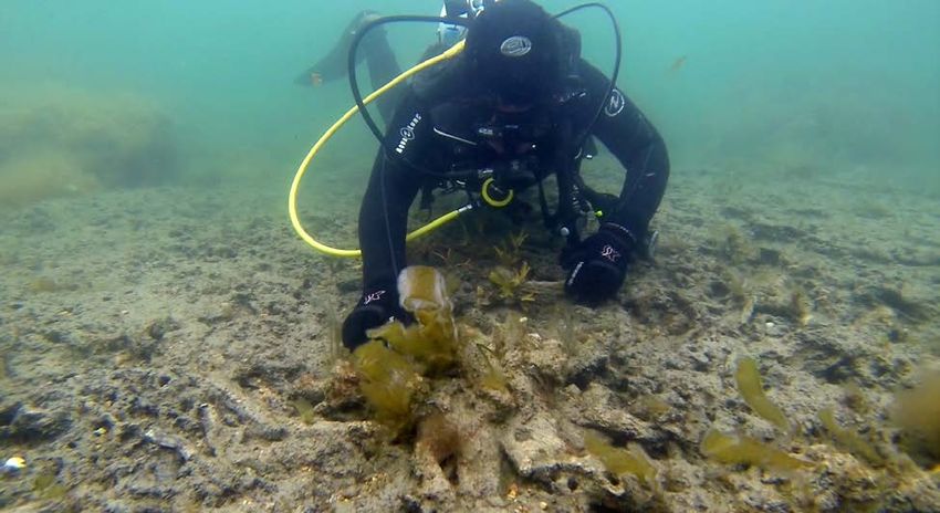
ABOUT THE COVER
Narragansett Indian Tribal member and University of Rhode Island undergraduate student project
specialist, Chali Machado, examines a tree-stump and its surrounding root-mat preserved in their original
growth positions in the exposed surface of a submerged paleocultural landscape dating from Cal BP 6555
to 6410, identified by URI-GSO during 2016 project field investigations conducted off of West Beach,
Block Island, Rhode Island. Photograph by David S. Robinson, URI-GSO.ACKNOWLEDGMENTS
This project was a product of listening and braiding together the many voices of the people who
generously shared their time, energy, ideas, wisdom, perspectives, concerns, comments, questions,
knowledge, hard work, talents, facilities, equipment, photographs, and video footage during the
performance of the Submerged Paleocultural Landscapes Project. The following individuals who
contributed to this effort are as follows:
• Glenn Anderson (Coastal Plumbing)
• Ivar Babb (University of Connecticut)
• Alberta and Michael Baccari (Cedar Tree Point Homeowners’ Association)
• David Ball (Bureau of Ocean Energy Management)
• Monique LaFrance Bartley (University of Rhode Island Graduate School of Oceanography)
• Daniel Belknap (University of Maine – Orono)
• Jon Boothroyd (University of Rhode Island)
• John Brown, III (Narragansett Indian Tribal Historic Preservation Office)
• John Brown, IV (Narragansett Indian Tribal Historic Preservation Office)
• Jessica Burke (University of Rhode Island)
• Brian Caccioppoli (University of Rhode Island Graduate School of Oceanography)
• Danielle Cares (University of Rhode Island Graduate School of Oceanography)
• Vincent Carlone (Block Island Police Department)
• Brandi Carrier (Bureau of Ocean Energy Management)
• Barbara and Raymond Chace (Ponaug Marina)
• Dennis Coker (Lenape Indian Tribe of Delaware)
• Dwight Coleman (University of Rhode Island Graduate School of Oceanography Inner Space
Center)
• John and Robin Cooney (Cedar Tree Point Homeowners’ Association)
• Michael Dalton (University of Rhode Island Graduate School of Oceanography)
• Melanie Damour (Bureau of Ocean Energy Management)
• Sean Davis (University of Rhode Island)
• Sierra Davis (University of Rhode Island Graduate School of Oceanography)
• Alex DeCiccio (University of Rhode Island Graduate School of Oceanography Inner Space
Center)
• Jørgen Dencker (Viking Ship Museum [Roskilde, Denmark])
• Tim Dencker (DTU Aqua, Center for Ocean Life [Kongens Lyngby, Denmark])
• Simon Engelhart (University of Rhode Island)
• Amanda Evans (Coastal Environments, Inc.)
• Jennifer Ewald (Bureau of Ocean Energy Management)
• Janet Friedman (Rhode Island Coastal Resource Management Council)
• Grover Fugate (Rhode Island Coastal Resource Management Council)
• Andrew Gallonio (Cedar Tree Point Homeowners’ Association)
• Rick Getchell (Aroostook Band of Micmacs; All Nations Global Solutions)
• Tammie Getchell (All Nations Global Solutions)
• Carol Gibson (University of Rhode Island Graduate School of Oceanography)
• Rae Gould (Nipmuc Nation; University of Massachusetts-Amherst)• Andrea Gringas (University of Rhode Island Graduate School of Oceanography Inner Space
Center)
• Valerie Grussing (NOAA Marine Protected Areas Center)
• Maryellen Hall (Cedar Tree Point Homeowners’ Association)
• Anya Hansen (University of Rhode Island)
• Doug Harris (Narragansett Indian Tribal Historic Preservation Office)
• Casey Hearn (University of Rhode Island Graduate School of Oceanography)
• Clifford Heil (University of Rhode Island Graduate School of Oceanography)
• Willie Hoffman (Bureau of Ocean Energy Management)
• Leah Hopkins (Narragansett Indian Tribe)
• Muckquashim Hopkins (Narragansett Indian Tribe)
• Joseph Houlihan (Block Island Ferry)
• Timothy Ives (Rhode Island Historical Preservation & Heritage Commission)
• Thomas Jacques (Cedar Tree Point Homeowners’ Association)
• Elizabeth James Perry (Wampanoag Tribe of Gay Head [Aquinnah] THPO)
• Arrow Johnson (Shinnecock Indian Nation)
• Brian Jones (Office of the Connecticut State Archaeologist)
• Douglas Jones (Bureau of Ocean Energy Management)
• Brian Jordan (Bureau of Ocean Energy Management)
• Mitchell Kennedy (University of Rhode Island)
• John King (University of Rhode Island Graduate School of Oceanography)
• Taylor Losure (University of Rhode Island)
• Chali Machado (Narragansett Indian Tribe; University of Rhode Island)
• Norman Machado (Narragansett Indian Tribe; University of Rhode Island)
• Jason Mancini (Mashantucket Pequot Museum)
• Joseph Mangiafico (University of Rhode Island)
• Catalina Martinez (NOAA Office of Ocean Exploration & Research)
• Victor Mastone (Massachusetts Board of Underwater Archaeological Resources)
• Kevin McBride (University of Connecticut; Mashantucket Pequot Museum)
• Jennifer McCann (University of Rhode Island Coastal Resource Center)
• James Moore (Bureau of Ocean Energy Management)
• Cameron Morissette (University of Rhode Island Graduate School of Oceanography)
• Nakai Clearwater Northup (Mashantucket Pequot Tribal Historic Preservation Office)
• Bryan Oakley (Eastern Connecticut State University)
• Marcos Paiva (United States Army Corps of Engineers – New England District)
• Jonathan Patton (Massachusetts Historical Commission)
• Clifford Payne (Payne’s Dock)
• Jean Pelletier (AECOM)
• Jonathan Perry (Wampanoag Tribe of Gay Head [Aquinnah] Tribal Historic Preservation
Office)
• Ramona Peters (Mashpee Wampanoag Tribal Historic Preservation Office)
• David and Leann Pickering (Cedar Tree Homeowners’ Association)
• Robert Pockalny (University of Rhode Island Graduate School of Oceanography)
• James Quinn (Mohegan Tribal Historic Preservation Office)
• Neil Redmond (University of Rhode Island)
• David Robinson (University of Rhode Island Graduate School of Oceanography)• Michael Robinson (University of Rhode Island)
• Noah Robinson (Rhode Island College)
• Sean Scannell (University of Rhode Island)
• William Schwab (United States Geological Survey)
• Gail Scowcroft (University of Rhode Island Graduate School of Oceanography Inner Space
Center)
• Gerrod Smith (Shinnecock Indian Nation)
• Kiowa Spears (Narragansett Indian Tribal Historic Preservation Office)
• Cheryl Stedtler (Nipmuc Nation)
• Charlotte Taylor (Rhode Island Historical Preservation & Heritage Commission)
• Elaine Thomas (Mohegan Tribal Historic Preservation Office)
• Ted Timreck (Smithsonian Institution, Timreck Productions/Spofford Films Inc.)
• Philip Verhagen (Vrije Universiteit [Amsterdam, Netherlands])
• Joseph Waller (The Public Archaeology Laboratory, Inc.)
• Ingrid Ward (Flinders University [Adelaide, Australia])
• Bettina Washington (Wampanoag Tribe of Gay Head [Aquinnah] Tribal Historic Preservation
Office)
• David Weeden (Mashpee Wampanoag THPO)
• Lauren Wenzel (NOAA Office of National Marine Sanctuaries)
• Kieran Westley (Ulster University [Coleraine, Northern Ireland, United Kingdom])
• Christopher and Gretchen Willis (Breezehaven)
• Christopher Wright (CR Environmental, Inc.)Contents
List of Figures ................................................................................................................................................ ii
Abbreviations and Acronyms ........................................................................................................................ ii
1 Introduction ............................................................................................................................................. 1
1.1 Project Description and Goals....................................................................................................... 1
2 Summary of Project Tasks and Deliverables.......................................................................................... 2
2.1 Project Meetings and Workshops, and Initial Project Workshop Report ...................................... 2
2.2 Literature Review and Synthesis, and Reference Database ........................................................ 4
2.3 Field Investigations and Report..................................................................................................... 5
2.3.1 2013 Field Investigations ...................................................................................................... 7
2.3.4 2014 Field Investigations ...................................................................................................... 7
2.3.5 2015 Field Investigations ...................................................................................................... 7
2.3.6 2016 Field Investigations ...................................................................................................... 8
2.5 Geoarchaeological Modeling Report ........................................................................................... 12
2.6 Spatial Data Transfer .................................................................................................................. 13
2.7 Documentary Film ....................................................................................................................... 15
3 Conclusions and Recommended Next Steps ....................................................................................... 16
3.1 Overview ..................................................................................................................................... 16
3.2 Next Steps for Developing Effective and Culturally Sensitive Consultation .............................. 16
3.2.1 General Observations ......................................................................................................... 17
3.2.2 Near-Term Next Steps ........................................................................................................ 17
3.2.2.1 Tribal Concerns .................................................................................................................. 17
3.2.2.2 Recommendations for Addressing Near-Term Tribal Concerns ........................................ 18
3.2.3 Long-Term Next Steps ........................................................................................................ 19
3.2.3.1 Tribal Concerns .................................................................................................................. 19
3.2.3.3 Recommendations for Addressing Long-Term Tribal Concerns ........................................ 20
3.3 Next Steps for Improving the Scientific Research Methodology Used to Characterize
Submerged Paleocultural Landscapes ................................................................................................... 20
3.3.1 Researcher Concerns ......................................................................................................... 20
3.3.2 Recommendations for Addressing Researcher Concerns .................................................. 21
References .................................................................................................................................................. 23
iList of Figures
Figure 1. Study area locations. .................................................................................................................. 6
Abbreviations and Acronyms
AMI Area of Mutual Interest
BOEM Bureau of Ocean Energy Management
CRMC Coastal Resource Management Council [Rhode Island]
DOI Department of the Interior
NEPA National Environmental Policy Act
NHPA National Historic Preservation Act
NITHPO Narrangansett Indian Tribal Historic Preservation Office
NROC Northeast Regional Ocean Council
OCS Outer Continental Shelf
OCSLA Outer Continental Shelf Lands Act
RI SHPO Rhode Island State Historic Preservation Office
RIHPHC Rhode Island Historical Preservation and Heritage Commission
THPO Tribal Historic Preservation Office
URI University of Rhode Island
URI-GSO University of Rhode Island Graduate School of Oceanography
USET United South and Eastern Tribes
ii1 Introduction
1.1 Project Description and Goals
This Final Report provides a summary description of the multi-year study entitled “Developing Protocols
for Reconstructing Submerged Paleocultural Landscapes and Identifying Ancient Native American
Archaeological Sites in Submerged Environments” (hereafter "the Submerged Paleocultural Landscapes
Project,” “the project,” or “the study”). The project was conducted by the University of Rhode Island’s
(URI’s) Graduate School of Oceanography (URI-GSO) and its research partners, the Rhode Island
Coastal Resource Management Council (CRMC) and the Narragansett Indian Tribal Historic Preservation
Office (NITHPO), over a seven-year period between 2012 and 2019, and involved the multidisciplinary
investigation of five nearshore and offshore areas in Rhode Island waters (Figure 1).
The study was performed with funding from and in collaboration with the United States Department of
the Interior’s (DOI) Bureau of Ocean Energy Management (BOEM) as part of a cooperative agreement
between URI-GSO and BOEM. At the time of this project, BOEM’s statutory authority did not allow it to
enter into cooperative agreements directly with Tribes, so BOEM, instead, worked with Tribes through a
third party, such as URI-GSO. The Outer Continental Shelf Lands Act allows BOEM to enter into
cooperative agreements with “Affected States.” Because Rhode Island is an affected coastal state, BOEM
entered into a cooperative agreement with URI, a state institution. The project was particularly suited for
synergistic interaction of multiple facets of expertise and knowledge between BOEM, URI-GSO, and
NITHPO.
The Outer Continental Shelf (OCS) of the United States is increasingly becoming the focus of
conventional and renewable energy development to meet the nation’s energy needs. Consideration of the
effects this development may have on submerged historic properties, including Native American (Tribal 1)
cultural sites submerged by post-glacial sea level rise and now underwater on the continental shelf, is a
legislatively mandated responsibility under multiple laws and statutes 2 for Federal agencies, including
BOEM, during their review and permitting of these offshore activities. It is also a significant concern for
individual states, Tribes, other regulatory agencies, stakeholders, and researchers that participate in the
environmental review and consultation processes for offshore development projects.
This project was not related to any specific consultation or intended to serve any regulatory function, but
was instead a research project, the purpose of which was to generate new information and knowledge
designed to assist the State of Rhode Island, southern New England Tribes, and BOEM in future planning
and decision making. The project’s overall goals were to:
1. Enhance and refine the scientific understanding of submerged paleolandscape preservation and
distribution on the Rhode Island OCS with particular focus on areas of Tribal significance.
2. Contribute to the development of a clearly-defined, standardized methodology to identify
submerged areas with cultural significance to contemporary Tribal people.
1 In this document, the term “Tribal” or “Tribe” is used to represent all Native American indigenous communities, regardless of
recognition status. Indigenous groups' interests in ancestral territory and resources, and the validity of their traditional knowledge
and cultural practices, is not dependent on Federal or state recognition status.
2Outer Continental Shelf Lands Act (OCSLA); National Environmental Policy Act (NEPA); National Historic Preservation Act
(NHPA)
13. Assist with the development of effective, culturally sensitive collaboration and consultation
between Federal and state agencies, researchers, and Tribes who work together as part of the
National Historic Preservation Act (NHPA) Section 106 compliance process.
1.2 Project Scope
Project goals were met by completing eight interrelated tasks and deliverables, inclusive of this Final
Report. Project tasks were completed in collaboration with URI-GSO’s project partners, as well as with
the input and assistance of representatives from multiple federally and state-recognized Tribes, Federal
and state agencies, industry, and regional and international academic instutions (see Acknowledgments at
the beginning of this report). Each task required a unique approach and workflow, and resulted in a
detailed written, digital, or video deliverable. This report provides only a brief summary of each task, and
the reader is referred to the full deliverable (referenced in parentheses below) for the complete results and
discussion.
The tasks and deliverables completed for the project included the following:
• Meetings, workshops, and an initial project workshop report (Coastal Mapping Laboratory 2015)
• Literature synthesis and reference database
• Field investigations, assessment of field methodology and a field report (Cacciopolli et al. 2018)
• Best practices report (Robinson et al. 2018)
• Geoarchaeological modeling report (Robinson et al. 2020)
• Geospatial data transfer (Gibson 2019)
• Documentary film (DeCiccio 2019)
• Final Report (this report)
2 Summary of Project Tasks and Deliverables
2.1 Project Meetings and Workshops, and Initial Project Workshop Report
Participation in multiple meetings and workshops was an integral element of the project scope and
occurred throughout the project. The overall goal of these meetings and workshops was to initiate and
support a multi-year discussion and exchange of ideas between the project partners and the broader
academic, agency, industry, and Tribal communities. These meetings helped inform all project research,
field investigations, and the development of the project best practices and geoarchaeological model.
The project began with an all-day Post-Award Meeting held at BOEM’s Atlantic OCS Regional Office in
Herndon, Virginia on September 20, 2012. The main purpose of the meeting was to kick-off the project,
introduce project partner leads and BOEM project staff, and discuss expectations and any questions
regarding the project’s scope, deliverables, and timeline. Detailed minutes documenting the meeting were
prepared by URI-GSO and submitted to BOEM as the first project deliverable (Robinson 2012).
2The 2012 Post-Award Meeting was followed by a three-day initial project workshop held between April
8–10, 2013. A total of 55 representatives from four different countries, eight different Federal- and state-
recognized Tribes (representing a region extending from Maine to Delaware), five Federal agencies, eight
state agencies, six universities, two museums, and four consulting firms participated in the workshop. The
goals of the initial project workshop were to:
• Review and recommend best practices that would help inform the development of Tribally
sensitive, science-based guidelines for identifying, avoiding, or mitigating adverse effects to
submerged paleocultural sites on the OCS. Of particular importance was the synthesis and
incorporation of Tribal, agency, academic, and industry perspectives into these best practices.
• Identify appropriate techniques and steps that would foster open communication and meaningful
interaction among all parties throughout the project.
• Develop a common understanding and language for the cultural and scientific aspects of the
project.
• Provide an overall understanding of the origins, goals, objectives, and tasks for the project.
• Promote open and respectful dialog with participating Tribes.
The first two days of the workshop were held at URI-GSO Narragansett Bay Campus in Narragansett,
Rhode Island. Each of these days was divided into moderated, subject-specific sessions in which invited
speakers gave short oral presentations, which were followed by open discussion between all attendees of
the material presented. Topics discussed included: “How Do You See Things?”; Origin and Significance
of [the project’s] Research Initiative; Our Current State of Knowledge; Integrating Tribal Values and
Information; Critical Aspects of the Submerged Paleocultural Landscapes Initiative; The Impact of Sea
Level Rise and Marine Transgression on Submerged Paleolandscapes; Evidence-Based Reconstructions
of Submerged Cultural Landscapes and Predictive Modeling; and the Nature and Excavation of
Submerged Settlements. Blank posters with a variety of different subject headings, such as “Best
Practices for Integrating Tribal/Non-Tribal Oral Histories Into Predictive Modeling,” “General
Concerns/Issues,” and “Opportunities,” were affixed to the walls of the workshop room. Participants were
provided with blank “Post-It” notes, encouraged to document anonomously their thoughts and concerns,
and asked to attach the notes to the approprate poster at any time during the conference. An on-site
reception for all conference participants was held at the conclusion of Day 1 to facilitate additional
interaction and informal discussion. The completed posters and Post-It note comments were revisited
during Day 2, which focused on a discussion of perspectives and expectations for the project and the
initial development of best practices for paleoenvironmental reconstruction, predictive modeling of site
locations, integration of Tribal oral histories and non-Tribal science into predictive modeling,
identification of submerged paleolandscapes, and submerged settlement site identification and excavation.
Day 3 of the workshop was held at the Narragansett Indian Tribe’s Longhouse in Charlestown, Rhode
Island, and consisted of concluding two Open Forum sessions. The first session was limited to Tribal
attendees. The second session was opened to include Tribal attendees and project partners from URI-GSO
and BOEM.
The primary outcomes of the initial project workshop were the initation of truly collaborative and
respectful dialog between the academic, agency, industry, and Tribal communities, and the opportunity to
begin working together towards a common goal. Although meaningful, positive progress was made
3towards achieving the workshop’s goals, the dialog that occurred throughout the workshop sessions
indicated that it was premature to expect that those goals could be fully realized during just three days of
interaction. Although participants clearly needed more time to process cognitively, symbolically, and
spiritually the content and meaning of the workshop’s discussions, all said that they appreciated the
opportunity to be part of such a necessary and exciting dialog, and that the workshop had been a
meaningful experience on both personal and professional levels. Individuals who attended the workshop
commented that they thought it was an important starting point towards establishing open lines of
communication, building trust and respect, establishing common goals, and developing transparent and
mutually agreed upon best practice protocols for identifying submerged paleocultural landscapes.
Knowledge gained during the initial workshop was utilized by the project partners in the study’s
subsequent research and collaborative efforts, especially in the development of the project’s best practices
and geoarchaeological modeling documents. A detailed description of the workshop and its
recommendations is presented in the Summary Report of the Initial Project Workshop prepared by URI-
GSO and submitted to BOEM in 2015 as a project deliverable (for more information, see Coastal
Mapping Laboratory 2015).
An Inter-Tribal Interim Project Workshop was held at the Narragansett Indian Tribe Longhouse on
September 17, 2015, to update the southern New England region’s Tribes on the project’s progress and to
request comments and input on how best to ask for and integrate Tribal knowledge and oral histories into
the project’s predictive modeling process for identifying areas of the OCS with variable potentials for
containing submerged ancient Native American sites. This meeting resulted in several important insights
concerning ancient Tribal oral histories and traditional ocean knowledge that were later incorporated into
the project’s best practices and modeling documents.
Additional important project-related meetings included multiple presentations given by the URI-GSO and
NITHPO project leads, with periodic participation by the BOEM project lead, during the United South
and Eastern Tribes (USET) Culture and Heritage Committee meetings between 2014 and 2018. USET is a
nationally prominent and respected inter-Tribal organization with 27 federally recognized Tribal Nation
members whose broad policy platform, annual meetings, and initiatives influence the most important and
critical issues facing all of Indian Country. The purpose of presenting to USET was to initiate dialog
about the project and its goals and to seek input and advice from a broader Tribal community. Project
partners from URI-GSO and NITHPO introduced the project to the USET Culture and Heritage
Committee in June 2014 at their Semi-Annual Meeting in Bar Harbor, Maine. Subsequent updates on the
project were given periodically by the project partners at USET’s Impact Week Meetings in Washington,
DC. The final project update to the USET Culture and Heritage Committee was on February 6, 2018,
summarizing the project’s best practices document (Robinson et al. 2018) and presenting for discussion
URI-GSO’s recommendations for near-term, intermediate-term, and long-term next steps for moving
forward with the implementation of these best practices.
2.2 Literature Review and Synthesis, and Reference Database
This task was completed early in the project (2013) and entailed the performance of a detailed review and
synthesis of available relevant marine archaeological, geological, and geophysical survey data and
literature. This information was then compiled into a reference database that provided background
information supporting the performance of subsequent project research tasks. The deliverable generated
by this task and provided to BOEM consisted of two parts: 1) a bibliographic listing of written resources
directly applicable to this project (i.e., scientific journal articles, books, technical reports, papers, etc.);
and 2) a geospatial compilation and mapping of legacy data from previous marine surveys, within and in
the vicinity of the project study areas and the surrounding southern New England region, that were
available publically from online databases, through collaboration with our colleagues, or by accessing an
archive at the URI-GSO. The written resources in the bibliography were organized by subject. Topics
4covered in the compiled references included paleolandscape reconstruction and mapping, predictive
modeling, marine geology and marine processes specific to Rhode Island and southern New England, and
previous archaeological research. The marine geological survey database focused on previously recorded
bathymetry, sidescan sonar, subbottom profiles, vibracores, and sea floor surficial geologic interpretations
in the study areas. Accompanying the reference database in this task’s deliverable were five maps
(organized by data type) that illustrated the geographic location and extent of previously collected data
relevant to the project. All of the maps were created using ESRI's ArcInfo Desktop software. Supporting
data layers in each map were organized in geodatabases, which facilitated their delivery in a digital
format to BOEM. Because these maps were designed to summarize the location of previously collected
data rather than contain the data itself, hyperlinks were included in the digital ArcInfo documents, so that
users can “mouseover” the data of interest on the map and connect directly to the online data source for
additional information and download options.
2.3 Field Investigations and Report
Field investigations were conducted for the project between 2013 and 2016 in four of the project’s five
study areas illustrated in Figure 1: 1) Gorton Pond, a glacially formed kettle pond in central Rhode Island;
2) Cedar Tree Beach/Greenwich Bay, a protected coastal/nearshore shallow embayment location in
central Narragansett Bay; 3) Block Island/West Beach, a coastal/nearshore island location approximately
19 km offshore; and 4) the “Mud Hole,” an area south of Narragansett Bay in the open ocean waters
Rhode Island Sound. Although these areas (and the fifth study area, the Rhode Island and Massachussetts
Area of Mutual Interest (AMI) for commercial wind development) are separated by tens of kilometers,
they share the same regional geologic and paleocultural history, which is key to identifying and
characterizing preserved paleocultural landscapes. The distinction between terrestrial and submerged
environments is obvious in the contemporary landscape, but ancestral Tribal peoples who occupied this
area interacted with a landscape that was very different from contemporary conditions, due to the effects
of deglaciation and post-glacial sea level rise.
Project field investigations performed each year by the project partners were conducted following a Work
Plan approved by BOEM and NITHPO, under a Phase I Intensive Archaeological Survey Permit issued to
project co-Principal Investigator, David Robinson (URI-GSO), by the Rhode Island State Historic
Preservation Office (RI SHPO) (i.e., the Rhode Island State Historical Preservation and Heritage
Commission [RIHPHC]) (RI Permit No. 12-25). Fieldwork was also performed with authorization from
the RI CRMC (RI CRMC Authorization No. 2013-08-038). Field investigations conducted for the project
consisted of marine geophysical/remote sensing survey, marine geotechnical sediment sampling, and
marine geoarchaeological investigations. The overall goals of these geological and geoarchaeological
investigations were the following:
• Assess the extent to which relict paleolandsapes survived post-glacial sea level rise in the study
areas and whether or not they contained paleocultural deposits
• Understand the geologic processes associated with paleocultural landscape preservation
• Identify environmental proxies associated with preserved paleocultural landscapes that could be
used to develop predictive models regarding the archaeological sensitivity of the seafloor
5• Test the efficacy of existing and new survey equipment and methods for identifying and
characterizing paleocultural landscapes
Figure 1. Study area locations.
Legacy data areas are shown with dark blue shading. Newly acquired data, or legacy data reinterpreted for the
project, are outlined in red and identified with yellow call-out boxes.
Field investigations took into account comments and recommendations voiced by Tribal participants
during the project’s initial workshop, described above. As such, the work progressed in phases from the
least-to-most invasive investigation techniques with an overall goal of minimizing the disturbance to the
seafloor as much as possible during the performance of all phases of the field investigations.
The project field report prepared and submitted to BOEM as a project deliverable (Caccioppoli et al.
2018) summarized the field operations at each study area in detail and provided an assessment of the field
methodology and data acquisition procedures at each location. Descriptions of the project’s field
6investigations were organized chronologically by year and by study area location and are briefly
summarized below.
2.3.1 2013 Field Investigations
Field investigations in 2013 focused on Gorton Pond and Cedar Tree Beach/Greenwich Bay study areas
and included the following activities:
• Sediment coring (Gorton Pond) to obtain samples for radiocarbon dating and paleoenvironmental
characterization.
• Gradiometric remote sensing and visual sediment probing to
1. Test the hypotheses that: a) an element of the paleolandscape is preserved submerged and
buried off of Cedar Tree Beach; and b) that this paleolandscape may have been utilized by
pre-contact period inhabitants and, therefore, could be a source of some of the pre-contact
period stone artifacts appearing in Cedar Tree Beach’s swash zone.
2. Test and evaluate the combination of close-interval (i.e., 1-m track line spacing) gradiometric
survey and visual sediment probing, for identifying submerged paleocultural landscapes; and
educate Tribal research partners in the application and use of geophysical survey equipment
and non-disturbance marine remote sensing survey methods.
2.3.4 2014 Field Investigations
Field investigations in 2014 focused on Cedar Tree Beach/Greenwich Bay study area and included the
following activities:
• Sediment coring in the shallow waters off of Cedar Tree Beach.
• Geoarchaeological subsurface sampling/excavation of two 1-x-1 m test units at locations
identified by the previous year’s gradiometric or visual sediment probing surveys as having
magnetic anomalies potentially associated with a paleocultural hearth feature or stratigraphy
suggestive of intact stratified paleolandsurfaces.
2.3.5 2015 Field Investigations
Field investigations in 2015 focused on the Block Island/West Beach and Mud Hole study areas and
included the following activities:
• Sediment coring conducted in Block Island’s Wash Pond (a small coastal pond adjacent to West
Beach) and in the Mud Hole study area. Coring in the Mud Hole study area was conducted from
URI’s scientific research vessel Endeavor as Cruise EN-565. The project's academic, Federal
government, and Tribal scientists working together on board URI’s R/V Endeavor gained first-
hand experience collaborating and performing marine geoarchaeological field research (obtaining
non-disturbance remote sensing data and selective vibracore sediment samples) for the project on
a large scientific research vessel in the offshore environment. A real-time digital audio-visual
connection between the ship and shore-based members of the project team, interested Tribal
members, and members of the general public was provided and maintained by the URI-GSO’s
7Inner Space Center, allowing a diverse segment of the public access to project activities occurring
at sea in real-time.
• Non-disturbance/minimal disturbance intertidal and subtidal visual reconnaissance archaeological
walk-over and diver surveys of the waters off of West Beach in areas with exposed organic
peat/paleolandsurface deposits to map their extent and assess their paleocultural archaeological
sensitivity.
2.3.6 2016 Field Investigations
Field investigations in 2016 focused on Block Island/West Beach and an area south of Narragansett Bay
and included the following activities:
• Geophysical remote sensing survey (sidescan sonar and CHIRP subbottom profiler) of the West
Beach/Block Island study area and a portion of Block Island’s Great Salt Pond, and subbottom
profiler survey and sediment coring operations conducted south of Narragansett Bay as part of
URI’s scientific research vessel Endeavor as Cruise EN-580. Participation in a BOEM-,
Northeast Regional Ocean Council- (NROC-), and Rhode Island Endeavor Program-supported
offshore educational and capacity-building cruise proposed and organized by the URI-GSO team
with academic (local and international), Federal government and regional Tribal participants. The
purpose of the cruise was to provide experience and training in marine geoarchaeological method
and theory, technologies, and scientific practices, as well as to create opportunities for in-depth
discussions and honest and open conversations about some of the difficulties and concerns
associated with agencies, Tribes, and academic researchers working together. Possible future
directions for continuing and supporting collaborative and community-based Tribal ocean science
and research were also discussed. Real-time digital audio-visual connectivity between the ship
and shore-based members of the project team, interested Tribal members, and members of the
general public was, once again, provided and maintained by the URI-GSO's Inner Space Center.
• Continuation of non-disturbance/minimal disturbance visual reconnaissance archaeological diver
surveys of the waters off of West Beach in areas with exposed organic peat/paleolandsurface
deposits to map their extent and assess their paleocultural archaeological sensitivity.
2.4 Best Practices Report
A best practices report (Robinson et al. 2018) was produced as one of the primary deliverables for the
project. The purpose of the best practices document was to serve as an initial guide for improving the
effectiveness and appropriateness of Tribal engagement and geoarchaeological research. These topical
areas form the bases for successful government-to-government consultation associated with Federal
project review and effective identification and protection of submerged historic properties. Respectful
engagement and collaborative relationships are the foundation for mutually beneficial and successful
consultation. What appears to have been largely absent from most previous Federal agency guidance
documents has been recommended procedures about how to establish and develop these relationships
before engaging in consultation. Consultation cannot be expected to function optimally without an
established basis of respectful and effective communication, trusting and mutually beneficial
relationships, and shared capacities among the involved groups to become and remained engaged as
collaborative partners. The best practices document addressed these underlying issues and provided new
insights regarding relationships with Tribal communities from the perspective of people working within
the various existing regulatory and developmental collaborative relationship frameworks. It was intended
8to provide recommendations concerning the actual steps that are required to achieve the stated goals of
Federal and state agency assessment and identification guidance documents. The document was not
intended to provide new standards to be implemented during consultation. Instead, the best practices were
intended to be informational, and to support Federal and state agencies, Tribal communities, and
researchers.
The best practices report recommended additional development in three key areas is required to optimize
successful consultation between agencies, Tribes, and researchers: a) communication; b) relationship
building; and c) capacity-building. Improvement in each of these areas is essential to the identification
and protection of submerged paleocultural landscapes in the offshore development project review process.
Areas of the OCS considered for federally permitted offshore activities should be characterized prior to
disturbance in a phased scientific process: a) a thorough desktop study resulting in a geospatial synthesis
of existing geoarchaeological information in the study area; b) an examination of sea level rise models
and the development of multiple paleoshoreline reconstructions based on each model; c) a detailed
reconstruction of the complete subsurface stratigraphy of the study area on a regional scale, and
identification of stratigraphic facies potentially associated with human habitation; d) paleoenvironmental
reconstructions of the study area for the time period of hypothesized habitation of the area; and e)
assessment of the paleocultural sensitivity of preserved paleolandscapes in the study area. Although the
project’s recommended best practices were created within a Rhode Island geographic research
context, they were intended to be broadly applicable to multiple geographic areas and should be seen as
dynamic recommendations that require periodic updating as new information, technologies, ideas,
and priorities become available and evolve over time.
The best practices report highlighted multiple areas that require additional development in order to
support future multicultural collaborative research and marine spatial planning in submerged
environments. The three key areas for which immediate action could be implemented, along with
recommended next steps for beginning to address them (in bullets) include the following:
1. Develop a standardized methodology for identifying areas of paleolandscape preservation in
submerged environments, instead of attempting to use predictive models to simply locate
areas with the highest potential for containing submerged archaeological sites.
Applying traditional archaeological predictive modeling approaches currently used on land to the
OCS is problematic due to the limited amount of pre-existing geologic and paleoenvironmental data
that is available and, with a few exceptions, the near total absence of detailed archaeological data for
the submerged environment. In addition, developing models of paleocultural sensitivity in submerged
environments requires almost total dependence on geophysical remote sensing and geotechnical
sediment sampling equipment, making it extremely challenging to conduct the highly detailed level of
archaeological site identification and evaluation that is necessary for testing predictive models. The
most important question currently to be answered about the paleocultural sensitivity of submerged
environments is not “Where and how did ancestral peoples interact with currently submerged
paleolandscapes,” which traditional predictive models might assist with, but instead, “Are any
paleolandscapes actually preserved in the area of interest?” If preserved paleolandscapes are located,
then additional investigations to assess the extent of preservation, the type of oceanographic processes
that resulted in their preservation, and the paleoenvironmental characteristics of the preserved
landscape must be conducted before any assessment of paleocultural sensitivity can be initiated.
In addition to the current lack of geologic, geophysical, and cultural data available for submerged
environments, researchers and Tribal representatives who attended this project’s initial workshop
emphasized that the results of predictive models should not be used as the primary method for
9decision making to identify geographic areas of cultural importance (Coastal Mapping Laboratory 2015).
For these reasons, research in the near future should focus on addressing data gaps in the
submerged environment to understand the extent and type of submerged paleolandscape preservation,
rather than on applying predictive models to poorly defined submerged environments in an effort to
identify archaeological sites.
• Until additional data becomes available, and the capacity of agencies, Tribes, and researchers
to share information respectfully and collaboratively improves, adopting a more holistic, Tribal
Cultural Landscape approach to the site identification process (Ball et al. 2015) should be
investigated and considered. This approach views preserved relict landforms, not “sites,” as
places of cultural importance.
• Investigate alternative methods to traditional archaeological predictive modeling to assess
areas of cultural importance in submerged environments. Begin with a thorough literature
search across multiple disciplines about the types of models that may be of assistance, and
then develop pilot studies to test the models for assessment of paleocultural sensitivity in
submerged environments.
• Develop a comprehensive, publicly available, digital geospatial database of geologic,
geophysical, and archaeological information available for the OCS and other submerged
environments of interest. Include a compilation of the sea level change models available for each
area and contact information for researchers with demonstrated expertise in the geology,
geophysics, and archaeology of each geographic area. Include contact information for Tribal
representatives and links to information about Tribal history, practices, and cultural priorities for
each area. Consider providing funding opportunities for agencies, local researchers, and Tribes to
work together to develop this database.
2. Increase the capacity of Tribal communities, agencies, and academic researchers to work
together in a mutually respectful and beneficial manner.
The identification and protection of submerged paleocultural landscapes benefit from an approach
that is multidisciplinary and multicultural in nature. Applying the diverse perspectives, information,
ideas, and knowledge of engaged partners from the agency, scientific, and Tribal communities to the
research and management problems associated with submerged paleocultural landscapes
identification and protection offers the best opportunity for the most comprehensive and mutually
agreeable solutions. Successful collaboration requires each partner to have established baseline
capacities necessary for working together. Groups that have adequate staff (with the necessary
interest, experience, knowledge, training, and skills), facilities and infrastructure, and sustainable
sources of funding will be most able to implement best practices and be optimally positioned to take
advantage of opportunities to collaborate or consult. Consequently, building capacity across these
communities must be seen as a priority.
• Identify one or more staff members who want and are qualified to serve as the group’s lead for
developing and maintaining increased capacity for engaging in collaborative relationships with
other groups. This and/or these individual(s) should have demonstrated prior experience, success,
and a genuine commitment to facilitating collaboration with diverse groups.
• Initiate regular in-person meetings between the identified staff member(s) representing each
group to provide enhanced capacity for relationship building. Meetings should be held at least
10twice a year (or as often as mutually agreed upon), with each meeting organized and led by one of
the groups, following a rotation that changes with each meeting. The purpose of the initial
meeting would be to: a) present and discuss key recommendations of this best practices
document; b) to review and reach a consensus regarding baseline requirements for effective,
respectful oral and written communications; and c) discuss development of a mandatory, cultural
sensitivity training program for all individuals involved in these meetings and the establishment
of collaborative relationships between the groups. The training program is to be created by Tribal
and non-Tribal group members and include education about the world-view, professional and
personal responsibilities, goals, and concerns associated with each group that is participating in
the collaborative relationship.
• Develop a Tribal ocean research consortium comprised of multiple Tribal communities united in
their desire to build capacity to become active Tribal participants in the ocean sciences and to
engage Federal and state agencies, universities, and other research groups in seeking funding
opportunities.
3. Build personal relationships among individual members of the Tribal, agency, and research
groups.
The development of sustainable, long-term, respectful, and trusting relationships among the agency,
Tribal, and research groups is required to foster collaborative, mutually beneficial decision making.
The importance of this type of relationship between these groups is acknowledged by all, but the
challenges associated with attaining them remain significant. It is necessary to recognize that each
group is composed of individuals whose personal commitment is tied to an emotional aspect that
frequently controls his or her feelings about the other groups, and, ultimately, defines the nature of the
relationships. A personal commitment to multicultural relationship building is required for all
individuals involved in collaborative activities.
• Seek opportunities to develop personal relationships with individuals from diverse groups in
casual situations outside of the work environment. Informal interaction in one-on-one or small
group settings provides an opportunity for a foundation of care, trust, and understanding between
individuals and groups to develop, and can be a powerful way to address and eliminate
stereotypes and prevent conflicts.
• Non-Tribal individuals should consider attending local Tribal cultural events, such as powwows,
musical performances, or public ceremonies, and, upon invitation, visiting nearby Tribal lands to
see, experience, learn, and gain a deeper appreciation and understanding about traditional Tribal
sciences, practices, ceremonies, and beliefs, as well as places in the landscape that are of
importance to Tribal communities.
• Tribal individuals should consider attending “open campus” days at nearby research institution(s),
or attending public lectures at local libraries, to gain additional insight into the scientific research
process and projects underway in their local area. In addition, many local conservation groups,
agencies, colleges, and universities offer opportunities to become “citizen scientists” by
welcoming individuals of all ages and backgrounds to assist with data collection and
interpretation for environmental monitoring projects. These experiences provide important
opportunities for sharing diverse perspectives in a casual, friendly environment.
For a more detailed description of the project’s recommended best practices, see Robinson et al. 2018.
112.5 Geoarchaeological Modeling Report
The geoarchaeological modeling report (Robinson et al. 2020) was another of the primary deliverables for
the project. Geoarchaeological modeling is based on the generally accepted theories that there is an
association between past human activities and different types of paleolandforms and paleoenvironments,
which results in a material culture expression sometimes preserved within the present landscape in a
predictable manner. This association has been used with some success in terrestrial contexts onshore to
develop models that predict where cultural materials may be located (Kvamme 2006; Verhagen 2012).
One of the objectives of the project was to examine whether geoarchaeological modeling could be applied
effectively in the submerged environment to assist in making informed cultural resource management
decisions for the OCS.
Initially, BOEM’s scope for the project included the development of a predictive model for the Rhode
Island OCS based on information compiled from a three-day workshop convened at the start of the project
(Coastal Mapping Laboratory 2015). Although the workshop was an excellent venue for individuals from
diverse backgrounds to interact and share information, it revealed significant gaps in the available
geoarchaeological data and accessible Tribal oral tradition information considered necessary for
completing the project’s modeling effort as scoped. It also revealed that developing a standardized
methodology for modeling was a more complex and challenging task than originally anticipated.
Additionally, the workshop clarified that mutually beneficial and culturally sensitive relationships
between the diverse groups engaged in the project needed further development before effective
collaboration could take place. These challenges could not be fully addressed within the context of a
three-day workshop.
In response to the results of the workshop, the project’s modeling process was altered and organized into
the following six sequential steps:
1. Conduct a thorough literature review to understand the current state of knowledge regarding the
use of archaeological predictive models in submerged environments.
2. Conduct a detailed Desktop Study to synthesize the current state of geoarchaeological knowledge
in the study area into geospatial format.
3. Develop a modeling process that can be applied to any geographic area to assist with locating and
characterizing preserved paleocultural landscapes.
4. Develop regional sea level change and stratigraphic models to assist with locating and
characterizing preserved paleolandscapes or paleolandscape fragments on the Rhode Island OCS.
5. Apply the modeling process and model (developed in steps 3 and 4 above) to the project study
area by conducting geoarchaeological investigations in five diverse case study areas.
6. Develop recommendations about the use of predictive models in submerged environments,
specifically with respect to identifying paleocultural landscapes of Tribal significance.
The geoarchaeological modeling document produced for the project presented the results of the tasks
outlined above. Section 1 of the report provided the context for the project’s modeling task. Section 2
provided a synthesis of the key geoarchaeological modeling concepts that are necessary to understand the
potential applicability of terrestrial modeling to the submerged environments. Section 3 presented a
process for submerged study area characterization that can be applied to a variety of geographic areas,
and used when diverse types, amounts, and resolution of data are available. Section 4 compiled the results
12You can also read