Woolwich Common: Ecological Survey & Management Plan, April 2022 - March 2027
←
→
Page content transcription
If your browser does not render page correctly, please read the page content below

Woolwich Common: Ecological Survey &
Management Plan, April 2022 - March 2027
February 2022

Denis J Vickers BSc (Hons), FLS, CBiol, MRSB, MCIEEM
Consultant Ecologist

Mobile: 07888677730
E-mail: denis@consultantecologist.co.uk
Web: www.consultantecologist.co.uk
79 Davington Road, Dagenham RM8 2LR
For the attention of:

Jenny SHERRELL
sherrelljenny@gmail.com
Friends of Woolwich Common
Contents:

Executive Summary .................................................................................................................... 2

1.     INTRODUCTION ................................................................................................................ 3

2.    METHODS ........................................................................................................................ 12

3.    SURVEY RESULTS .......................................................................................................... 18

4.    SITE EVALUATION ........................................................................................................... 29

5.    CONCLUSIONS AND RECOMMENDATIONS ................................................................. 32

6.    MANAGEMENT PRESCRIPTIONS .................................................................................. 37

7.    REFERENCES .................................................................................................................. 50

Appendix 1: Habitat plan ........................................................................................................... 53

Appendix 2: Vascular plant species list .................................................................................... 55

Appendix 3: Management Compartments ................................................................................ 66

Appendix 4: Legislation and Policy .......................................................................................... 67

Appendix 5: Site photographs ................................................................................................... 74

Appendix 6: Stag beetle loggeries and boxes .......................................................................... 85

Acknowledgements: The author wishes to thank Sheila Gahagan for assisting with the survey.

Copyright:

© This Report is the copyright of Denis J Vickers. Any unauthorised reproduction or usage by any
person other than the addressee(s) is strictly prohibited.

Woolwich Common: Ecological Survey & Management Plan, April 2022 – March 2027

   Executive Summary
  •    Denis J Vickers (Consultant Ecologist) was commissioned by the Friends of Woolwich
       Common to undertake a habitat survey of Woolwich Common. The survey ran from
       September 2020 through to August 2021, overall, 44.7ha of chiefly woodland, scrub,
       roughland and grassland were reviewed. The site is currently designated as of Borough
       Importance for Nature Conservation in Royal Borough of Greenwich. The land
       surveyed is wholly owned and maintained by the MoD but largely given over to public
       use.

  •    Woolwich Common is split into two sections by an east-west scarp just north of the
       site’s centre. The northern area is chiefly covered in acid grassland or semi-improved
       acid grassland although there are pockets of semi-improved neutral grassland and tall
       herbs intermingled. There are also a number of scattered trees at the roadside
       perimeters.

  •    The southern section is quite different to that north of the scarp. It is chiefly covered in
       neutral grassland, tall herbs and scrub. The edges are largely wooded with native and
       non-native trees and shrubs. To the south-east is an old reservoir now partly reed
       covered.

  •    A habitat survey of the site, following a modified Phase 1 survey methodology was
       carried out in during 2020 and 2021.

  •    The chief survey objectives were to:

              ⎯ Record all vascular plant types found on site and their relative abundance
              ⎯ Record readily identifiable fauna particularly birds, butterflies and Odonata.
              ⎯ Identification of plant species of particular note or rarity and placing them in a
                   geographic context, i.e., important locally, borough-wide, in Greater London
                   and nationally.
              ⎯ Identify invasive species listed under Schedule 9 of the Wildlife and
                   Countryside Act 1981 and the London Invasive Species Initiative (LISI).
              ⎯ Identifify habitat types present and an assessment of their extent and quality.
              ⎯ To act as a baseline survey and to inform a programme of appropriate
                   ecological management for the site.

  •    A five-year management plan was formulated and is included as part of this report.

Denis J Vickers – Consultant Ecologist                                                   page 2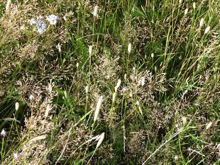
Woolwich Common: Ecological Survey & Management Plan, April 2022 – March 2027
1. INTRODUCTION
1.1 Background
1.1.1 Denis J Vickers (Consultant Ecologist) was commissioned by the Friends of
Woolwich Common (The Friends) to undertake a detailed habitat survey of Woolwich
Common (the Common). The survey ran from September 2020 through to August 2021,
overall, 44.7ha of chiefly woodland, scrub, roughland and grassland were reviewed
(Appendix 1). The site is currently designated as of Borough (Grade 1) Importance for
Nature Conservation (SBINC) in Royal Borough of Greenwich. This is a designation
afforded sites of nature conservation value seen as important in a borough context and
adopted by the relevant local authority. The land surveyed is wholly owned and
maintained by the MoD but largely given over to public use.
1.2 Location and context
1.2.1 Woolwich Common is located just north of centre of the Royal Borough of
Greenwich. To the north is Haha Road; to the west a car park, Stadium Road and Queen
Elizabeth Hospital; to the south Shooters Hill Road (A207); and to the east Academy
Road and Woolwich Common (A205). Beyond these features there is largely housing
and associated developments on all bar the northern end of the site where Barrack Field
and the Royal Artillery Barracks are located. National Grid reference TQ4275677287
lies at the centre of the site. Woolwich Town Centre lies approximately 1km to the north-
east. The Borough’s policies map (adopted 2014) shows the Common designated as
Metropolitan Open Land, Green Chain and as a Conservation Area. A roughly
rectangular area abutting Haha Road (from the Manège eastwards) is also shown as
subject to UDP Site Proposal Schedules.
1.3 Geology, topography and drainage
1.3.1 Geology
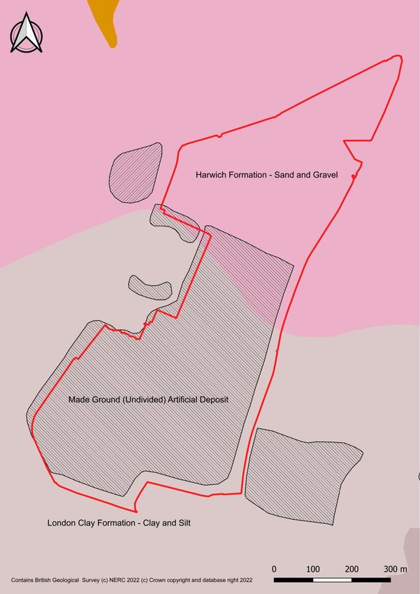
a) The British Geological Survey (Figure 1 below) shows the southern part of the site
underlain with the clay and silt of the London Clay Formation bedrock. These
sedimentary rocks are marine in origin and were formed during the Paleogene 34 to 56
million years ago. They are detrital and comprise coarse- to fine-grained slurries of
debris from the continental shelf flowing into a deep-sea environment, forming
distinctively graded beds.
Denis J Vickers – Consultant Ecologist page 3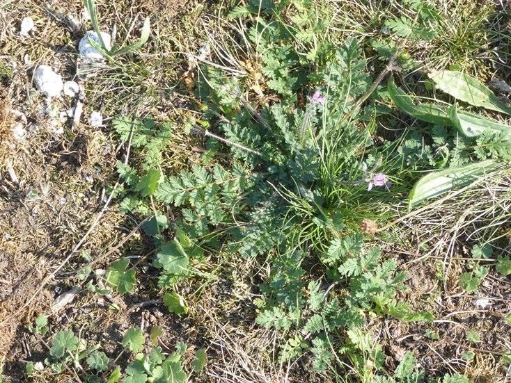
Woolwich Common: Ecological Survey & Management Plan, April 2022 – March 2027

     Figure 1: Geology of Woolwich Common

Denis J Vickers – Consultant Ecologist                                          page 4
Woolwich Common: Ecological Survey & Management Plan, April 2022 – March 2027

     b) the northern part of the site is underlain with the sand and gravels of the Harwich
     Formation bedrock. These sedimentary rocks are shallow-marine in origin. They are
     detrital, ranging from coarse- to fine-grained (locally with some carbonate content)
     forming interbedded sequences. They were formed during the Paleogene 34 to 66
     million years ago.

     c) Most of the London Clay area mentioned above is over capped with made ground the
     composition of which is not stated and possibly not determined. This material was
     probably deposited early in the second half of the 20th century.

     1.3.2 Topography

     The southern end of the Common has been subject to raising and mounding with several
     metres of various deposits in the past. The extent of these deposits is shown as the
     north-eastern edge of the made ground shown in Figure 1 above. On the ground this
     appears as a scarp effectively cutting the site into two. The land falls from over 70m in
     the south-east corner of the site to just under 60m at the north-eastern edge of the made
     ground. The land elevation falls a further 10m or so as the northern end of the site is
     approach. The southern section of the common is characterised by woodland at the
     edges, with scrub and roughland (an intimate mixture of scrub, tall herbs and rough
     grassland) in the hinterland. Land north of the scarp overwhelmingly comprises
     grassland with just a few scattered trees. There is a small wetland (an old reservoir) in
     the south-eastern corner of the site. The only road which cuts through the Common is
     Circular Way at the northern apex, although there are several surfaced footpaths as well
     as desire lines. Just south of Haha Road is an artificially surfaced Manège with a
     mounded boundary to the west and south.

     1.3.3 Drainage

     The are no obvious watercourses on site. Drainage is like to be via percolation through
     porous deposits down to the impervious London Clay and northwards towards Haha
     Road and Circular Way, following the lay of the land. Drainage ditches are shown on the
     Environment Agency’s Main River Map in this location.

Denis J Vickers – Consultant Ecologist                                                page 5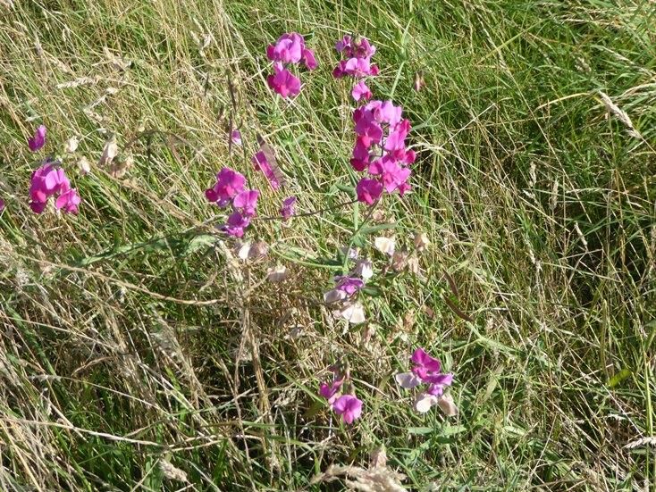
Woolwich Common: Ecological Survey & Management Plan, April 2022 – March 2027

1.4       History

      History taken from the Friends of Woolwich Common website
      https://friendsofwoolwichcommon.org.uk/history/ , unless otherwise referenced.

      1.4.1 Until the 19th century, Woolwich Common comprised roughly 32.4ha, stretching
      from Shooters Hill down towards Charlton and was deemed to be part of the manor of
      Eltham and ultimately owned by the Crown. The land was poor and the Common was
      used by locals for herbage (pasture for grazing animals), turbary (turf-cutting for fuel)
      and estovers (collecting of wood for building materials and fuel). The Woolwich Vestry
      strongly defended the customs of the locals and, around the 1760s, fought the building
      of houses on the west edge of the Common. However, from the 1720s the Board of
      Ordnance, a governmental body, started using the Common for ordnance and by the
      1770s also for artillery practice, thereby sometimes endangering the cattle which were
      on the Common for herbage.

      1.4.2 The Board of Ordnance, with permission from King George III, continued to expand
      their use of the Common and between 1800 and 1810 had enclosed Barrack Field at the
      north of the Common (separated by the rest of the Common by a ha-ha, which still runs
      alongside Haha Road and is classified as a Listed Building). Permission was granted to
      build both the Royal Artillery Barracks at the northern edge and the Royal Military
      Academy at the south-eastern edge, moving officer and cadet training from “the Warren”
      by the Thames edge within Woolwich. In 1812 the Common was finally purchased from
      the Crown by the Military. The parish were paid £3,000 in compensation, although
      disputes continued for several years now that herbage, turbary and estovers rights were
      prevented. During the 1800s, the Common was used for artillery practice from both
      Barrack Field and the Royal Military Academy as well as an area to practice troop
      manoeuvres.

      1.4.3 [paragraph reference Newsom S & Williams A, 2009]
      The relationship between the military and the local inhabitants remained complex into
      the 20th century. In 1928 a committee was formed which aimed to facilitate use of the
      land by both the military and the local community. The committee noted that the space
      available on the Common had halved due to the activities of the War Office. The
      military’s hold of the Common was reported as being ‘as tight as ever’. Footpaths were
      closed, buildings erected, and local people discouraged from using the area. In 1930 the
      north of the site was regularly used for training and parades whilst the southern end of

Denis J Vickers – Consultant Ecologist                                                  page 6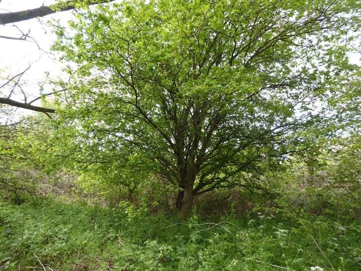
Woolwich Common: Ecological Survey & Management Plan, April 2022 – March 2027

     the common was rarely used. With regards to this report, it is interesting to note that an
     original heathland flora was reported as still present at this end of the Common.

     1.4.4 The Royal Horse Infirmary was located on the south-western tip of the Common,
     and the Shrapnel Barracks were built on the west edge of the Common in the mid-19th
     Century, later to be replaced by the Queen Elizabeth Military Hospital (opened in 1978)
     and which later became the Queen Elizabeth hospital in 2001, transferred in 2009 to the
     Lewisham and Greenwich NHS Trust. Some land on the west edge of the Common is
     still leased to the Trust for their carparks. The Common also had both the Brook and
     Herbert hospitals on the southern edge along Shooters Hill Road, both developed into
     residential apartments in the 2000s.

     1.4.5 [paragraph reference Newsom S & Williams A, 2009]
     In 1844 a circular reservoir was built in the south-eastern corner of the Common by the
     Kent Water Company to supply many of the institutions around the Common. Today, the
     position of this feature is marked by a reedbed and scattered willow and alder trees (see
     Appendix 1).

     1.4.6 During the 1920s a large stadium was built along the western edge; this is now the
     car-park area of the Queen Elizabeth Hospital. It had a capacity for 20,000 seated or
     45,000 standing and was used for many sporting events but was particularly famous for
     its military tattoos. During the Second World War heavy anti-aircraft guns were located
     close to the stadium. The structure was heavily damaged by bombing and during the
     1950s it only continued to be used by the Chelsea and Charlton football clubs.

     1.4.7 The eastern edge of the Common which, during the early 1800s housed officers
     and staff for the Academy, was by the 1930s considered poorly built and designated
     slum-clearance sites. During the 1960s and 1970s they were developed and formed part
     of the Woolwich Common Estate.

     1.4.8 Further north, the Woolwich Garrison Church of St George was once at the end of
     the Barracks’ parade ground, but today is separated by A205 (Grand Depot Road).
     Building of the church started in 1861 – it was grand and capacious, holding over 1500
     soldiers. The church was heavily damaged by a flying bomb in 1944 and what remains is
     currently being restored as far as possible by a specialist team. The interior still houses
     some incredible mosaics.

     1.4.9 The northern edge of the Common, along Haha Road, was the location from 1916
     for the Signals Experimental Establishment (SEE) which experimented in wireless
Denis J Vickers – Consultant Ecologist                                                 page 7
Woolwich Common: Ecological Survey & Management Plan, April 2022 – March 2027

     telegraphy and produced inter-aircraft communication systems and secure field-
     telephones. After the First World War work continued and engineers based there,
     developed sound location systems (pre-Radar) and echo-location systems. The SEE
     was re-built during the 1930s and by 1949 became the Atomic Weapons Research
     Establishment (AWRE) which worked on early development phases of Britain’s first
     atomic bomb, Blue Danube, work which was later continued at Aldermaston. The
     establishment was eventually deemed uneconomic and closed in 1963.

     1.4.10 [paragraph reference Newsom S & Williams A, 2009]
     Documentary and aerial photographic evidence shows that the northern section of the
     Common has been greatly disturbed and levelled for 20th century recreational purposes.
     Additionally, the earlier impact of artillery training was must have been significant. The
     area is criss-crossed with modern paths and desire lines. Narrow trenches carrying
     services across the Common are visible as grass marks or earthworks.

     1.4.11 [paragraph reference Newsom S & Williams A, 2009]
     Photographs from 1945 show huge piles of soil at the southern end of the Common.
     Thousands of tonnes of earth were reported as being dumped on the Shooters Hill end
     of the Common. The deposition of earth probably commenced sometime after 1930 with
     most of the material likely to have been deposited during the Second World War (the
     London Ecology Unit (1998) reported this a being blitz rubble topped with soil - a
     common practice elsewhere in London). Apparently, this material was reused in the
     construction of sea defences at Plumstead Marshes after the devastating floods of 1953
     (visible evidence on site suggests that not all this material was reused). The scarp
     dividing the Common into northern and southern sections appears to have been created
     when the Heavy Anti-Aircraft (HAA) battery was levelled in the early 1950s.

     1.4.12 A large part of the northern section of the Common was used to host archery and
     shooting events for the 2012 Olympic Games. Venues can be seen under construction in
     August 2011 using Google Historical Imagery. Although the facilities were disassembled
     post Olympics, scarring of the land was still apparent in April 2017 (ibid). An account
     from May 2013 by Sarah Trotter (newsshopper.co.uk) describes the poor condition of
     this part of the Common. A photograph from the time shows a large area covered in
     stony, claggy soil in which ruderal plant species are beginning to grow. It seems
     restoration work which would include chain harrowing, rubble removal and reseeding

Denis J Vickers – Consultant Ecologist                                                 page 8
Woolwich Common: Ecological Survey & Management Plan, April 2022 – March 2027
was delayed due to inclement weather. No record of the type of seed used or areas
resown has been retrieved.
1.5 Ownership and Tenure
1.5.1 The Common is currently owned and maintained by the Defence Infrastructure
Organisation (DIO) which is part of the Ministry of Defence. However, it is largely left
open to public use.
1.6 The Friends of Woolwich Common
1.6.1 The Friends is a formally constituted volunteer group formed in 2019 to protect the
Common and pull together stakeholders to look after and promote the area. Membership
is open to all interested in furthering the aims of the group:
• protect and enhance Woolwich Common as a place of enjoyment and
recreation for all sections of the local community
• protect and enhance the ecology of the Common and diversity of the wildlife
• help residents contribute to the management and development of the open
space to ensure that it best serves the needs of the local community
• encourage the recreational use of the Common by supporting/creating events
and activities
• promote the cultural, educational, historical and environmental importance of
the common by working in partnership with the community, army, hospital,
Council and other interested parties
1.7 Outline of survey
1.7.1 A bespoke extended Phase 1 survey was employed. This comprised two chief
elements: (1) a desktop study (looking at geological, historical and biological / ecological
sources of information); and (2) a field survey using a modified Habitat Survey for
Denis J Vickers – Consultant Ecologist page 9Woolwich Common: Ecological Survey & Management Plan, April 2022 – March 2027
Greater London survey methodology1. In addition, readily identifiable fauna were listed.
The results of the field survey were combined with the information from the desktop
study to assess what protected, priority and otherwise notable species were present or
likely to be present. Overall, 44.7ha of land were surveyed (see Appendix 1).
1.7.2 The survey included an assessment of the effectiveness of past and ongoing
management in maintaining current nature conservation assets. Where appropriate,
alternative methods of management were recommended to maintain and / or enhance
the site’s biodiversity. Information gained will inform a programme of appropriate
ecological management for the site.
1.8 Purpose and objectives
1.8.1 Purpose
The information gathered will be used by the Friends in pursuance of its objectives
including working in partnership with the MoD and Greenwich Council.
The survey will include gathering up-to-date data concerning habitats and species as
well as observations about current site conditions, management and how the biodiversity
value of the site and its habitats, could be enhanced. Further surveys of priority and
protected species and potential monitoring schemes will be recommended where
appropriate.
1.8.2 Objectives include:
• Recording of all vascular plant types found on site (where it is practicable to
do so) and their relative abundance
• Recording readily identifiable fauna particularly birds, butterflies and Odonata.
• Identification of plant species of particular note or rarity and placing them in a
geographic context, i.e., important locally, borough-wide, in Greater London
and nationally.
1
This methodology was adopted by the Mayor of London in his Biodiversity Strategy in 2002. It was originally
developed in the mid-1980s by the Greater London Council with regards the first comprehensive survey of wildlife
habitats in Greater London
Denis J Vickers – Consultant Ecologist page 10Woolwich Common: Ecological Survey & Management Plan, April 2022 – March 2027
• Identification of invasive species listed under Schedule 9 of the Wildlife and
Countryside Act 1981 (as amended) and the London Invasive Species
Initiative (LISI).
• Identification of habitat types present and assessment of their extent and
quality.
• Target noting features and species of specific note.
• Vulnerability and potential threats to the integrity of habitats
• To act as a baseline survey and to inform a programme of appropriate
ecological management for the site
1.9 Qualifications and experience of surveyor and author:
1.9.1 Denis J Vickers BSc (Hons), FLS, CBiol, MSB, MCIEEM is one of the most
experienced habitat surveyors in Greater London and particularly skilled in undertaking
open space and habitat surveys using the Mayor of London’s methodology: Denis
carried out his first full London borough survey 30 years ago when he completed a
survey of Wandsworth Borough in 1992 for the London Ecology Unit. Between 1994
and 2007 Denis worked for the London Wildlife Trust (LWT) including a period as Habitat
Survey Manager supervising and carrying out habitat surveys for the Greater London
Authority. Whilst working in this capacity he surveyed six complete London boroughs.
Between 2007 and 2009 Denis worked as Senior Ecologist for EDAW plc (part of Aecom
Design and Planning). Between 2009 and 2016 Denis worked as Biodiversity Officer for
Harrow Council advising planning issues regarding biodiversity. He also participated in a
National Vegetation Classification (NVC) survey of ground flora in Richmond Park on
behalf of The Royal Parks. In 2016 Denis resurveyed all Sites of Importance for Nature
Conservation in the London Borough of Barking and Dagenham for the local authority. In
2016-17 he undertook a detailed ecological survey of Trent Country Park in Enfield for
the Friends of Trent Park. In 2018 Denis led a team of surveyors in carrying out an
ecological impact assessment of Hainault Forest Country Park in L B Redbridge. An
ecological survey of the Becontree Estate in LB Barking and Dagenham was undertaken
for Create London in 2021.
Denis J Vickers – Consultant Ecologist page 11Woolwich Common: Ecological Survey & Management Plan, April 2022 – March 2027
2. METHODS
2.1 Desktop Study
2.1.1 A desktop study was carried out and the following information / data sourced and
reviewed in preparation for the habitat survey and report:
• British Geological Survey – Web Map Services
• English Heritage Woolwich Common - Woolwich, Greater London
• Environment Agency – Main River Map
• Friends of Woolwich Common website
• Google Historic Imagery and Google Earth
• Greenspace information for Greater London – data search
• London Biodiversity Partnership - London BAP Priority Habitats
• London Ecology Unit - Nature Conservation in Greenwich
• London Ecology Unit - Woolwich Common Management Brief
• London Invasive Species Initiative. - Species of Concern
• Ordnance Survey MasterMap
• Royal Borough of Greenwich - Biodiversity Action Plan
• Royal Borough of Greenwich - Core Strategy borough policies map
2.1.2 In addition, a search was completed of an on-line mapping service
(www.magic.defra.gov.uk) for statutory designated sites.
2.1.3 Consideration was given to Habitats and Species of Principal Importance for the
Conservation of Biodiversity in England listed under the Natural Environment and Rural
Communities (NERC) Act 2006 (as amended) and those covered by the London
Biodiversity Partnership Biodiversity Action Plan and Royal Borough of Greenwich
Biodiversity Action Plan that were confirmed to be, or are potentially, present at the site.
Denis J Vickers – Consultant Ecologist page 12Woolwich Common: Ecological Survey & Management Plan, April 2022 – March 2027
Finally, Rodney Burton’s Flora of the London Area was consulted in determining which
species of plant could be regarded as notable in Greater London.
2.2 Habitat survey
2.2.1 A habitat survey of the site was carried out comprising four visits on the 12th & 19th
of September 13th 2020 and the 1st May & 14th August 2021. Habitats were described
following Phase 1 survey methodology (JNCC 2010 & Mayor of London 2002).
2.2.2 Weather conditions on all four days were sunny and warm although it started off
cool and overcast on the 21-09-2020. The survey was conducted by a highly
experienced ecologist (see 1.9) and took just over 20 hours to complete.
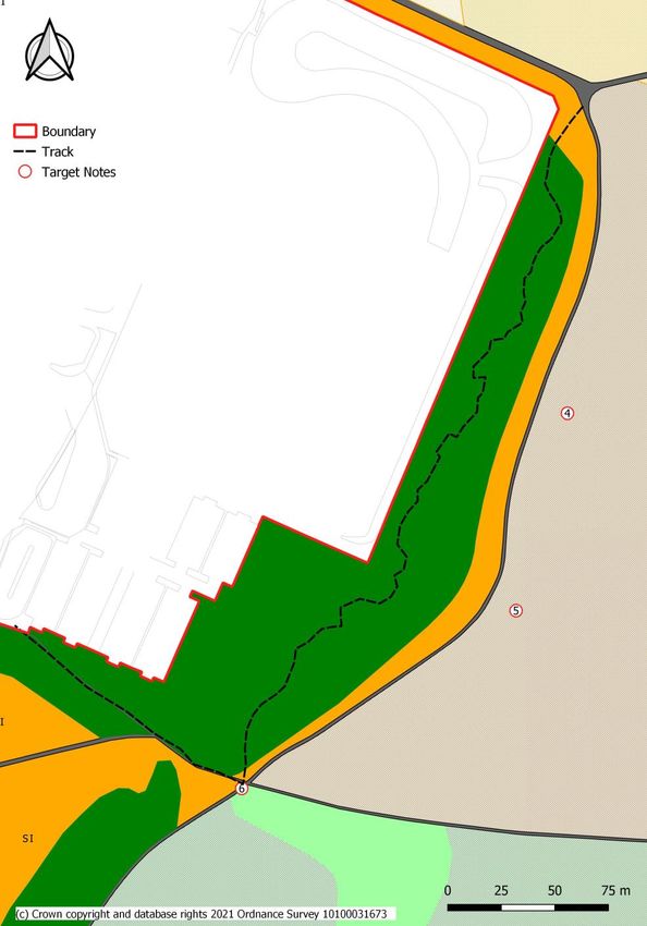
2.2.3 A description of habitat types present is given under paragraph 3.4. A map of the
site showing the chief habitats present appears in Appendix 1.
2.2.4 Characteristic, dominant or otherwise notable vascular plant species occurring
were recorded wherever possible, together with an assessment of their abundance using
the DAFOR scale2. Scientific names are given after the first mention of a vascular plant
species; thereafter common names only are used, nomenclature follows Stace (2019). A
full list of the vascular plants recorded appears in Appendix 2. This list also includes the
species listed by listed by the GiGL data search.
2.2.5 The following species were specifically noted and where isolated clumps or single
plants occurred, locations were target noted with a 10-figure grid reference using high
sensitivity GPS (locations are shown in Appendix 1):
• Species protected under Schedule 8 of the Wildlife and Countryside Act 1981
(as amended).
• Nationally rare species.
• Nationally scarce species.
• Red data book species.
2
This is an estimate of the relative abundance of species in this case for the Common as a whole. D=Dominant,
A=Abundant, F=Frequent, O=Occasional and R=Rare
Denis J Vickers – Consultant Ecologist page 13Woolwich Common: Ecological Survey & Management Plan, April 2022 – March 2027
• Species of Principal Importance in England. These species were identified as
requiring action in the UK Biodiversity Action Plan (UK BAP) and continue to
be regarded as conservation priorities in the subsequent UK Post-2010
Biodiversity Framework (Defra 2012).
• Notable species for the Greater London area. Notable is defined as species
which were recorded from 15% or fewer of the 400 two by two-kilometre
recording squares (tetrads) in Greater London in the Flora of the London Area
(Burton 1983).
• Non-native invasive species listed under schedule 9 of the Wildlife and
Countryside Act 1981 (as amended).
2.2.6 Interesting plants and other features were photographed Appendix 5.
2.2.5 Records of birds and other identifiable fauna noted during the habitat survey were
also recorded (Section 3.5).
2.3 Mapping
2.3.1 QGIS was used to create all maps and to record the positions of target notes.
Digitisation was over Ordnance Survey MasterMap to ensure accuracy.
2.3.2. The maps included the red line site boundary and habitat mapping.
2.3.3. QGIS was used to obtain site and habitat areas (in hectares) and relevant
centroids (as a 10-figure national grid reference).
2.4 Preliminary protected and priority species assessment
2.4.1 The potential of the wider site to provide habitat for protected and priority species
was assessed from field observations carried out at the same time as the habitat survey,
combined with the results of the desktop study.
2.4.2 The site was inspected for indications of the presence of protected and priority
species as follows:
• Bats - the presence of trees with cracks or holes (such as woodpecker holes),
splits or flaking bark and ivy; and buildings with basements, roof voids, soffits,
cladding etc. indicating potential for roosting bats. Positive field signs of bat
use include:
Denis J Vickers – Consultant Ecologist page 14Woolwich Common: Ecological Survey & Management Plan, April 2022 – March 2027
o Staining around a feature e.g., cracks, caused by natural oils in bat fur;
o Scratch marks around a feature, caused by bat claws;
o Bat droppings beneath a hole;
o Urine stains below the entrance to a hole.
• Eurasian badger (Meles meles)– evidence of badger use was noted (although
access was difficult in some parts). Field signs include the presence of:
o Setts
o Latrines
o Badger hair
o Footprints
o Feeding remains
o Badger paths
• European hedgehog Erinaceus europaeus - the presence of scats, runs,
diggings and/or nests was searched for and any evidence reported.
Additionally, areas with scattered trees, underlying scrub/planted shrubbery,
grass-cuttings and fallen leaves which might allow daytime summer resting
places and winter hibernicula;
• Breeding birds – dense scrub, holes in trees and nests from the previous year;
male birds in song holding territories; active nest sites and juvenile birds.
• Reptiles – a mixture of vegetation heights, tangled or thorny areas, mosaics,
bare patches with plentiful ecotones and good basking places; potential
refugia such as compost heaps and rubble piles.
• Amphibians – Amphibians (including great crested newt), the presence
suitable habitat, ponds, partially exposed tree roots, rotting vegetation, rubble
piles and other potential refugia;
• Stag beetle Lucanus cervus – rotting stumps of deciduous trees.
2.4.3 These protected species were selected for further consideration because
potentially suitable habitat is present on site (or nearby in the locality) and / or species
records retrieved from data search were relatively frequent. The likelihood of occurrence
is ranked as follows and relies on the current survey and evaluation of existing data:
Denis J Vickers – Consultant Ecologist page 15Woolwich Common: Ecological Survey & Management Plan, April 2022 – March 2027
• NEGLIGIBLE: while presence cannot be absolutely discounted, the site
includes very limited or poor-quality habitat for a particular species or species
group. No local returns from a data search, surrounding habitat considered
unlikely to support wider populations of a species/species group. The site
may also be outside or peripheral to known national range for a species.
• LOW: on-site habitat of poor to moderate quality for a given species/species
group. Few or no returns from data search, but presence cannot be
discounted based on national distribution, nature of surrounding habitats,
habitat fragmentation, recent on-site disturbance etc.
• MODERATE: on-site habitat of moderate quality, providing most or all of the
known key requirements of given species/species group. Has local returns
from the data search, within the national distribution and with suitable
surrounding habitat. Factors limiting the likelihood of occurrence may include
small habitat area, habitat severance, and disturbance.
• HIGH: on-site habitat of high quality for a given species/species group. Local
records provided by desk-top study. Site within/peripheral to a national or
regional stronghold. Good quality surrounding habitat and good connectivity.
• PRESENT: presence confirmed from the current survey or by recent,
confirmed records.
2.4.4 The purpose of this assessment is to identify whether more comprehensive Phase
2 surveys for protected species should be recommended.
2.5 Site evaluation
2.5.1 The site has been evaluated broadly as recommended by standard guidelines
(CIEEM 2016). In particular, the assessment of ecological value is made with reference
to criteria such as the following, placed in geographical context (significance from an
international level through to site level):
• Any designated sites or features, such as Sites of Local Importance for
Conservation, protected trees or important hedgerows.
• Biodiversity value of the habitats, assessed by considering the distribution and
status of habitats and species, including issues such as:
Denis J Vickers – Consultant Ecologist page 16Woolwich Common: Ecological Survey & Management Plan, April 2022 – March 2027
o habitat diversity and connectivity; and
o plant communities and/or animal groups that are considered typical of
valuable natural or semi-natural vegetation;
o especially species-rich plant or animal communities; and
o animal populations that are notably large in a wider context
• Presence of animal or plant species that are rare or threatened or in decline in
a national, regional or local context.
• Habitats and species of Principal Importance for Biodiversity under Section 41
of the Natural Environment and Rural Communities Act (NERC) 2006.
• Habitats and species included on local Biodiversity Action Plans.
• Habitats that are a material consideration in the planning process under NPPF
(e.g., ancient woodland and limestone pavement) and Section 41 of the
Natural Environment and Rural Communities Act (NERC) 2006.
• Presence of protected species.
2.6 Limitations
2.6.1 It should be noted that whilst every effort has been made to provide a
comprehensive description of the site, no investigation could ensure the complete
characterisation and prediction of the natural environment.
2.6.2 The habitat survey was undertaken during the optimum periods for vegetation
survey (regarded as May to September). Nevertheless, some components of vegetation
may have been missed or absent at the time of the survey or otherwise under recorded.
However, this is not considered to be a significant constraint to habitat assessment. This
habitat survey does not constitute a full botanical survey.
2.6.3 The protected and priority species assessment should provide a preliminary view
of the likelihood of these species occurring on the site, based on the suitability of the
habitat, known distribution of the species in the local area and any direct evidence on the
site. However, the data obtained from GiGL did not extend beyond the site boundary, in
fact the area to the north of Circular Way was absent altogether. Without these data the
degree of certainty in assessing whether a protected / priority species is present or not is
greatly reduced. At best the assessment should be taken as indicative only (unless a
particular species is found on site) and does not provide a full and definitive survey.
Denis J Vickers – Consultant Ecologist page 17Woolwich Common: Ecological Survey & Management Plan, April 2022 – March 2027
3. SURVEY RESULTS
3.1 Desktop study
3.1.1 Greenspace Information for Greater London (GiGL) supplied the following
protected and priority species records, of historical ecological interest from within the
site’s boundary (excluding the area north of Haha Road):
3.2 Protected and notable species
3.2.1 It is important to note that, even where data are held, a lack of records for a
defined geographical area does not necessarily mean that there is no ecological interest;
the area may be simply under-recorded.
3.2.2 West European Hedgehog Erinaceus europaeus
There was one occurrences of hedgehog reported by GiGL from the search area
originating from 2018.
3.2.3 Breeding Birds
GiGL returned a substantial number of records of birds from within the 1km data search
area the most relevant of which are tabulated below. An asterisk* indicates the author’s
opinion on whether likely to be breeding or not.
Table 1: Protected and priority bird species
#No.
of Most Status
Common name Scientific name occur. recent legal Status other
Lesser Redpoll Acanthis cabaret 1 1985 Sect.41 UKBAP, BRed
Common (Mealy)
Redpoll Acanthis flammea 1 1998 LBAP, LSOCC
LBAP, LSOCC,
Skylark* Alauda arvensis 18 1987 Sect.41 BRed
Meadow Pipit Anthus pratensis 29 2002 LSOCC
LBAP, LSOCC,
Tree Pipet Anthus trivialis 12 2000 Sect.41 BRed
Swift Apus apus 7 1997 LSOCC
Stock Dove Columba oenas 1 1997 LSOCC
Emberiza UKBAP, LBAP,
Reed Bunting schoeniclus 3 1996 Sect.41 LSOCC
Denis J Vickers – Consultant Ecologist page 18Woolwich Common: Ecological Survey & Management Plan, April 2022 – March 2027
#No.
of Most Status
Common name Scientific name occur. recent legal Status other
Kestrel* Falco tinnunculus 15 2010 WCA1i LSOCC
Ficedula
Pied Flycatcher hypoleuca 3 1995 LSOCC
Fringilla
Brambling montifringilla 1 1996 WCA1i
Swallow Hirundo rustica 10 2015 LSOCC
LBAP, LSOCC,
Linnet Linaria cannabina 8 1997 BRed
Grasshopper Luscinia
Warbler megarhynchos 1 2001 LSOCC, BRed
Red Kite Milvus milvus 1 2013 WCA1i
Yellow Wagtail Motacilla flava 12 1997 LSOCC, BRed
UKBAP, LBAP,
Spotted Flycatcher Muscicapa striata 6 2015 Sect.41 LSOCC, BRed
Honey-buzzard Pernis apivorus 1 2013 WCA1i
Phylloscopus UKBAP, LBAP,
Wood Warbler sibilatrix 1 1996 Sect.41 LSOCC, BRed
Phylloscopus
Willow Warbler trochilus 11 2002 LSOCC
Prunella
Dunnock* modularis 3 1998 LBAP, LSOCC
Bullfinch Pyrrhula pyrrhula 8 2011 LBAP
Sand Martin Riparia riparia 2 1996 LBAP, LSOCC
Whinchat Saxicola rubetra 43 2015 BRed
Stonechat Saxicola rubicola 12 2015 LSOCC
UKBAP, LBAP,
Turtle Dove Streptopelia turtur 1 1996 Sect.41 LSOCC, BRed
LBAP, LSOCC,
Starling Sturnus vulgaris 3 2002 BRed
Redwing Turdus iliacus 7 2011 WCA1i BRed
Turdus LBAP, LSOCC,
Song Thrush* philomelos 7 1997 BRed
Fieldfare Turdus pilaris 8 2011 WCA1i BRed
Ring Ouzel Turdus torquatus 2 1996 Sect.41 UKBAP, BRed
Mistle Thrush* Turdus viscivorus 5 2011 LSOCC, BRed
#No. of occur. = number of occurrences
Denis J Vickers – Consultant Ecologist page 19Woolwich Common: Ecological Survey & Management Plan, April 2022 – March 2027
3.2.4 Status abbreviations (more detail appears in Appendix 4)
a) Status Legal
• WCA1i = Wildlife and Countryside Act 1981, Schedule 1, Part i.
• Sect.41 = Section 40 & Section 41 of the NERC Natural Environment & Rural
Communities Act 2006
b) Status other
• UKBAP = The UK Biodiversity Action Plan.
• LBAP = Local (London) BAP species
• LSOCC = London Species of Conservation Concern
• IUCN (Mark Eaton et al, 2015)
⎯ BAmb = Bird Population Status – Amber
⎯ BRed = Bird Population Status – Red
3.2.5 Other protected/priority species
Additionally, within the search area, there are records of two invertebrates shown below
and six vascular plant species identified in Appendix 2.
a) Brown Argus Aricia agestis – a butterfly (LSOCC), one occurrence in 2016
b) Cinnabar Tyria jacobaeae – a moth (Sect.41, UKBAP, LBAP, LCOCC), one
occurrence in 2002.
3.3 Extended Phase 1 Habitat Survey
3.3 Overview
3.3.1 At 44.7ha Woolwich Common is a large area of semi-natural open space just north
of centre of the Royal Borough of Greenwich. The site is split into two sections by an
east-west scarp just north of the site’s centre. The northern area in chiefly covered in
acid grassland or semi-improved acid grassland acid although there are pockets of semi-
improved neutral grassland and tall herbs intermingled. There are also a number of
scattered trees at the roadside perimeters. The nature of the grassland chiefly reflects
the underlying geology and past and present land use and management.
3.3.2 The southern section is quite different to that north of the scarp. The edges are
largely wooded with native and non-native trees and shrubs (mapped as broadleaved
woodland). There are also three distinct areas of dense scrub south of centre of this
section. Aerial photographic evidence suggest that planting of these areas probably
Denis J Vickers – Consultant Ecologist page 20Woolwich Common: Ecological Survey & Management Plan, April 2022 – March 2027
started in the1960/70s and may have continued over several years. It is interesting to
note, there were no trees on the Common in 1945 other than a few lines aside Stadium
Road and Academy Road (Google Historical Imagery). The northern half of this section
is dominated by ‘roughland’. To the south, between the trees and areas of dense scrub,
is an expanse of scattered scrub. Finally, there is a small area of reed swamp in the
south-eastern corner. This marks the location of an old reservoir.
3.3.3 A definition and description of the chief habitats present is given below (not
necessarily in order of ecological importance) Additionally, any other features of
particular ecological importance are described. Photographs appear in Appendix 5.
3.4 Habitat descriptions
3.4.1 Scattered trees:
The main scattered trees on the Common are hybrid black poplar Populus x canadensis
(Photo 1). Some of these probably date back to the 1940s (or possibly before). Other
trees include Ash Fraxinus excelsior, London plane Platanus x hispanica, Norway maple
Acer platanoides, field maple A. campestre, rowan Sorbus aucuparia (Photo 2), and
silver birch Betula pendula.
3.4.2 Broadleaved woodland:
a) The Mayor of London (2002) defines this as woodland whereWoolwich Common: Ecological Survey & Management Plan, April 2022 – March 2027
c) Woodland ground flora comprises cow parsley Anthriscus sylvestris which is locally
dominant, abundant bramble Rubus fruticosus agg and ivy Hedera helix (Photo 6),
occasional hogweed Heracleum sphondylium and a few localised clumps of hybrid
bluebell Hyacinthoides x massartiana (Photo 7) in the western woodland adjacent to the
carpark.
3.4.3 Dense scrub
There is little space between individual shrub species which comprise this type of scrub.
Often any understorey (or field layer beneath) is suppressed or absent. There are three
blocks of dense scrub to the south of the Common. Together, these account for 2.27ha
(5.08%) of the site’s surface area. The most northerly of these chiefly comprises
hawthorn, whilst the other two contain mostly a species of cockspur-thorn Crataegus sp.
(London Ecology Unit, 1998).
3.4.4 Scattered scrub
a) This is an intermediate habitat type between dense scrub and roughland (below).
Individual shrubs or clumps of shrubs are relatively widely spaced (Photo 8). Other
habitats beneath and between the shrubs e.g., rough grassland and tall herbs are
prominent. Scattered scrub accounts for 7.67ha (17.16%) of the Common’s surface
area.
b) This habitat is located to the south of the area. Species include abundant bramble
Rubus fruticosus agg., frequent hawthorn, occasional, blackthorn Prunus spinosa and
dog-rose, young pedunculate oak and ash, dominant false oat-grass Arrhenatherum
elatius, frequent creeping thistle Cirsium arvense (Photo 9), and occasional yarrow
Achillea millefolium, horseradish Armoracia rusticana, hogweed and broad-leaved dock
Rumex obtusifolius. There is also one specimen of Japanese quince Chaenomeles
japonica (Photo 10) next to the footpath to the south-east of the area.
3.4.5 Roughland
a) Is defined as an intimate mix of scrub, tall herbs and semi-improved neutral grassland
(Mayor of London, 2002). This is located south of the scarp between the woodlands to
the east and the west (Photo 11). Roughland accounts for 6.40ha (14.32%) of the
Common’s surface area.
Denis J Vickers – Consultant Ecologist page 22Woolwich Common: Ecological Survey & Management Plan, April 2022 – March 2027
b) False oat-grass is dominant. Other species include frequent bramble, common nettle
Urtica dioica and horseradish; occasional hawthorn, blackthorn, elder sambucus nigra,
broad-leaved everlasting pea Lathyrus latifolius (Photo 12), large bindweed Calystegia
sylvatica, couch grass Elymus repens and cock’s-foot Dactylis glomerata. One small
clump of Japanese knotweed Reynoutria japonica (TN4) and amphibious bistort
Persicaria amphibia (TN5) were found in this area. The first example is an invasive
species scheduled under the Wildlife & Countryside Act 1981 (as amended).
3.4.6 Neutral grassland (semi-improved)
a) Are grasslands with medium levels of soil nutrients usually with one or more of
Arrhenatherum elatius (Photo 13), Deschampsia cespitosa, Alopecurus pratensis,
Cynosurus cristatus, Dactylis glomerata and Festuca arundinacea. Contains more than
just Lolium perenne, Trifolium repens, Rumex acetosa, Taraxacum, Bellis perennis and
Ranunculus species (Mayor of London, 2002). At Woolwich Common these grasslands
cover 4.99ha (11.16%) of the site’s surface area mostly to the south-west.
b) These grasslands have a tussocky appearance (Photo 14). False oat-grass is
dominant, other grass species include cock’s-foot, couch grass smooth meadow-grass
Poa pratensis, annual meadow-grass P.annua and perennial rye-grass Lolium perenne.
Forbs include yarrow, cow parsley, creeping thistle, creeping buttercup Ranunculus
repens, white clover Trifolium repens and daisy Bellis perennis. On the edge of this area
(TN6) are several specimens of yellow vetchling Lathyrus aphaca (Photo 15). This
species is notable in London, a Species of Conservation Concern in London and
classified as nationally scarce.
3.4.7 Acid grassland (unimproved)
a) These grasslands develop on nutrient poor, sandy or gravelly, lime deficient soils in
lowland Britain. Typically, they haveWoolwich Common: Ecological Survey & Management Plan, April 2022 – March 2027
b) The site’s acid grassland comprises dominant common bent Agrostis capillaris (Photo
16) and red fescue Festuca rubra. The London Ecology Unit (1998) also identified
sheep’s-fescue F. ovina as being a major component. Sheep’s sorrel Rumex acetosella
(Photo17) is frequent as is cat’s ear Hypochaeris radicator (Photo18), small cat’s-tail
Phleum bertolonii, and yarrow. Other species often associated with acid grassland occur
including occasional common bird’s-foot trefoil Lotus corniculatus (Photo 19), buck’s-
horn plantain Plantago coronopus, hare’s-foot clover Trifolium arvense (Photo 20) and
rare Common Storksbill Erodium cicutarium (Photo 21), these last three species are
notable in Greater London. Broom Cytisus scoparius (TN3, Photo 22) is located to the
north of this area. It is an undershrub akin to gorse and heather and is often found
associated with these species.
3.4.8 Acid grassland (semi-improved)
a) This refers to acid grassland somewhat denatured by previous land use and / or
management. In this case the nature of the land has been modified via previous military
use, as a venue for the 2012 Olympics and subsequent restoration. Significant elements
of acid grassland remain but there are sizeable areas overtaken by semi-improved
neutral grassland and tall herbs (Photos 23 & 24). Overall, 11.22ha (25.10%) of the
Common’s surface area is covered in this habitat.
b) Species characteristic of acid grassland include abundant red fescue, frequent
common bent, buck’s-horn plantain, cat’s-ear and sheep’s-sorrel and occasional
common storksbill. Patches of semi-improved neutral grassland and tall herbs include
abundant ribwort plantain Plantago lanceolata; frequent cock’s-foot, smaller cat’s-tail,
perennial rye-grass, mugwort Artemesia vulgaris, yarrow and common ragwort Jacobaea
vulgaris (Photo 25); occasional creeping thistle and fennel Foeniculum vulgare (Photo
26); and rare viper’s-bugloss Echium vulgare (Photo 27) and canary grass Phalaris
canariensis (Photo 28). The last species is a casual of waste places. Hoary mustard
Hirschfeldia incana is frequent throughout the area. This is an indicator of disturbed
ground.
3.4.9 Reedswamp
This habitat accounts for 0.07ha (0.16%) of the surface area of the site. It is located in
the south-eastern corner of the common and is a relic of a previous early Victorian
reservoir. Common reed Phragmites australis dominates this area (Photo 29).
Denis J Vickers – Consultant Ecologist page 24Woolwich Common: Ecological Survey & Management Plan, April 2022 – March 2027
3.4.10 Bare artificial
This habitat accounts for 1.46ha (3.27%) of the surface area of the site (Photo 30). It is
of relatively little ecological value.
3.5 Fauna
a) Table 2 below lists species which were identified on Woolwich Common during the
survey visits.
Table 2: Fauna
Common name Scientific name Status
Birds:
Blackbird Turdus merula**
Blackcap Sylvia atricapilla**
Blue tit Cyanistes caeruleus**
Carrion crow Corvus corone*
Chaffinch Fringilla coelebs**
Great tit Parus major**
Greenfinch Chloris chloris
Magpie Pica pica**
Nuthatch Sitta europaea**
Ring-necked parakeet Psittacula krameria* WCA9/14i
Robin Erithacus rubecula**
Song Thrush Turdus philomelos** LBAP, BRed
Whitethroat Sylvia communis**
Woodpigeon Columba palumbus**
Wren Troglodytes troglodytes**
Butterflies:
Gatekeeper Pyronia tithonus
Meadow brown Maniola jurtina
Orange tip Anthocharis cardamines
Small copper Lycaena phlaeas
Small white Pieris rapae
Speckled wood Pararge aegeria
Odonata
Migrant hawker Aeshna mixta
Denis J Vickers – Consultant Ecologist page 25Woolwich Common: Ecological Survey & Management Plan, April 2022 – March 2027
Table 2: General abbreviations and symbols
*=Suitable habitat is present to support breeding, **=Confirmed breeding
Status abbreviations (more details appear in Appendix 4)
UK Legal: WCA1i = Wildlife and Countryside Act 1981, Schedule 1, Part i.
Sect.41 = Section 40 & Section 41 of the NERC Natural Environment & Rural Communities Act
2006
BAP-2007 = The UK Biodiversity Action Plan (UK BAP)
LBAP = Local (London) BAP species, LSOCC = London Species of Conservation Concern
IUCN (Mark Eaton et al, 2015): BAmb = Bird Population Status – amber, BRed = Bird Population
Status – red
3.6 Protected and Notable species assessment
3.6.1 The habitats at the site were evaluated as to their likelihood to provide sheltering,
roosting, nesting and foraging habitat for the following animals and support for plants:
• Bats
• Badger
• Hedgehog
• Breeding birds
• Amphibians
• Reptiles
• Stag beetle
• Native bluebell
• Yellow vetchling
3.6.2 These species were selected for further consideration because the species is
present or potentially suitable habitat is present on site (or nearby in the locality) and/or
species records retrieved from data search were relatively frequent. The results of the
field survey, combined with information from the desktop study, are presented in Table 3
below.
3.6.3 Invasive plant species which occur on site and are listed under Schedule 9 of the
Wildlife and Countryside Act 1981 (as amended) and other invasive/potentially invasive
species identified by LISI are also listed in the Table 3.
3.6.4 The relevant legislation relating to protected species and habitats and scheduled
invasive plant species is summarised in Appendix 4.
Denis J Vickers – Consultant Ecologist page 26Woolwich Common: Ecological Survey & Management Plan, April 2022 – March 2027
Table 3: Assessment of potential presence of protected and BAP priority species at Woolwich Common
Species Main legislation/Policy Type of areas where Reasons for consideration Likelihood of occurrence
(See Appendix 4) presence should be
considered
Bats Wildlife and Countryside Act Trees (particularly old Woodland habitat is often associated with LOW – Roosting on Common
1981 (as amended). specimens) with suitable bats both for roosting and foraging (roosting in surrounding buildings
Conservation of Habitats voids and/or dense (Collins, 2016) is more likely)
and Species Regulations coverings of ivy. Foraging HIGH – foraging / commuting
2010 & commuting along lines along lines of trees on the
of trees and shrubs e.g., Common
perimeter woodlands
Badger Protection of Badgers Act Across the site but Superficially some habitats on site appear NEGLIGIBLE – Habitat on site has
1992 (as amended) particularly in longer to be suitable for badgers been greatly modified over the
established areas of years, connecting habitat is
woodland and scrub generally poor
Western Section 41 of the Natural May forage over most of One record retrieved from GiGL data MODERATE
Hedgehog Environment and Rural site and may nest in search. Suitable habitat on site
Communities (NERC) Act suitable locations (particularly woodland and scrub)
2006 (as amended)
Breeding Wildlife and Countryside Act Woodland, scrub, mature Numerous records received from GiGL PRESENT
birds 1981 (as amended) trees and shrubs and including WCA1i/BOCC. Fifteen species
grassland recorded during this survey including
breeding Red & Amber list BOCC
Reptiles Wildlife and Countryside Act Areas with a mixture of Suitable habitats occur on site. However, NEGLIGIBLE
1981 (as amended) vegetation heights, the site has been greatly disturbed in the
tangled or thorny areas, past and links to other suitable green
mosaics, bare patches spaces are generally poor
with plentiful ecotones and
good basking places
Amphibians Wildlife and Countryside Act Ponds and wet areas, Suitable habitats occur on site possibly for LOW
including 1981 (as amended) logs, bricks, vegetation common toad. However, the site has been
great Conservation of Habitats and other suitable refuges greatly disturbed in the past and links to
crested other suitable green spaces are generally
Denis J Vickers – Consultant Ecologist page 27Woolwich Common: Ecological Survey & Management Plan, April 2022 – March 2027
Species Main legislation/Policy Type of areas where Reasons for consideration Likelihood of occurrence
(See Appendix 4) presence should be
considered
newt (GCN) and Species Regulations poor
2010 (GCN only)
Stag Beetle Wildlife and Countryside Act Rotting tree stumps of Stag beetle is moderately common in this LOW – The trees on the Common
1981 (as amended) deciduous trees area of south London are not particularly old – there is a
Schedule 5 general lack of suitable decay
wood
Native Wildlife and Countryside Act Woodland areas Record of native bluebell returned by NEGLIGIBLE
Bluebell 1981 (as amended) GiGL. This may have been misidentified,
Schedule 8 hybrid bluebell found in western woodland
Yellow Nationally scarce species Semi-improved grassland Found to the west of the site (TN6) PRESENT
Vetchling
Invasive Species
Section 14 and Part II of Any part of the site Goat’s-rue and Japanese knotweed occur PRESENT – Goat’s rue and
Schedule 9 of the Wildlife on site. The GiGL data search also Japanese knotweed
and Countryside Act 1981 retuned records of Cotoneaster sp.
(as amended)
London Invasive Species Whole site Butterfly-bush PRESENT
Initiative (LISI) INNS Spanish bluebell or hybrid (4)
Categories quoted in Holm oak (5)
brackets (column to the left). Green alkanet (6)
This is a non-statutory Snowberry (2) – GiGl record only
classification indicative of
invasive and potentially N.B. The full LISI list also comprises those
invasive species in the species appearing in Schedule 9 of the Wildlife
context of Greater London & Countryside Act (not included here).
Denis J Vickers – Consultant Ecologist page 28Ecological Survey of Woolwich Common and Management Plan, April 2022 – March 2027
4. SITE EVALUATION
4.1 Introduction
4.1.1 The value or potential value of an ecological resource or feature on site (i.e., habitats
and species) is evaluated following standard guidance on ecological impact assessment
published by the Chartered Institute of Ecology and Environmental Management (CIEEM,
2018). The following geographical frame of reference is used:
• International
• UK
• National (England)
• Regional (South-East)
• County (Greater London)
• District (London Borough of Greenwich)
• Local or parish (1km radius of site)
• Immediate zone of influence of the site (Site)
• Negligible
4.2 Features of value
4.2.1 Features of International Value:
a) Primarily these are sites covered by international legislation or conventions, such as
those sites designated under the Habitats Regulations3 and the Ramsar Convention (also
known as the Wetlands Convention). Examples include Special Areas of Conservation
(SACs), Special Protection Areas (SPAs) and Ramsar sites which are designated for
habitats and / or important populations of species.
3
Which implemented the Conservation of Natural Habitats and Wild Fauna and Flora (92/43/EC) (or Habitats Directive)
until leaving the EU
Denis J Vickers – Consultant Ecologist 29 | P a g eYou can also read