WORKING WITH NATURE IN THE ARABIAN GULF
←
→
Page content transcription
If your browser does not render page correctly, please read the page content below
MARITIME SOLUTIONS FOR A CHANGING WORLD #162 - SPRING 2021
10 YEARS ON
Advances in case law with respect
to adverse physical conditions
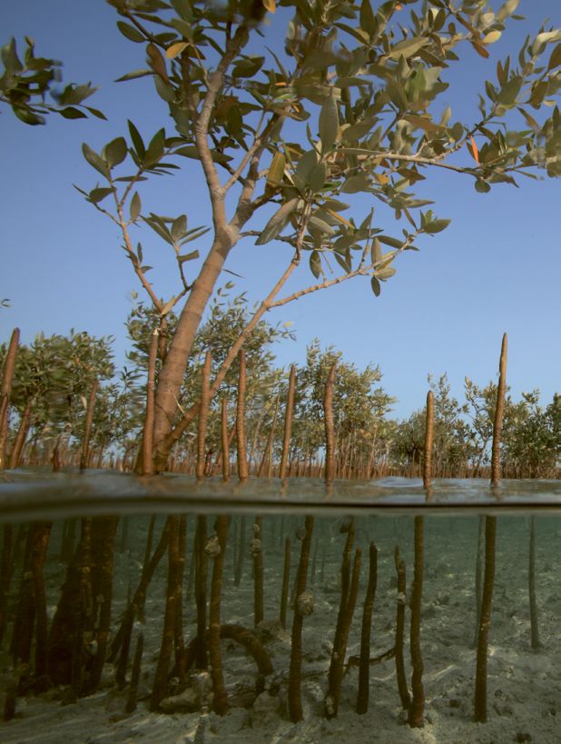
MANGROVE HABITAT
SEABED MANAGEMENT
First-of-a-kind demonstration
WORKING WITH plant that prevents harbour silting
NATURE IN THE
ARABIAN GULF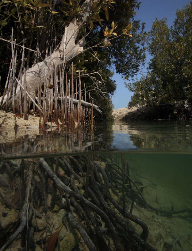
HIGHLIGHT

WORKING HAND IN HAND
SHORELINE PROTECTION
AND BIODIVERSITY
CONSERVATION

At Mubarraz Island near Abu Dhabi (UAE), an international oil company
beneficially reused ~12 million m3 of dredged material to protect oil pipelines,
construct a causeway and create mangrove habitat to manage coastal erosion.
Since 2006, a new ‘Working with Nature’ approach has been adopted in
response to increasing shoreline erosion by creating artificial tidal channels
that are excavated parallel along the causeway and planted annually with tens of
thousands of seedlings.

Owing to this innovative approach and persistent planting, mangrove vegetation
has been successfully established along nearly 7 km (~20%) of the causeway’s
shorelines. This unique case study demonstrates that the planting of mangroves
on dredged material is feasible, even under extreme climatic conditions, and can
offer a cost-effective nature-based solution for shoreline protection with added
benefits for biodiversity conservation. Read the full article on page 16.

2       TERRA ET AQUA
#162 - SPRING 2021 3
CONTENTS

 CONTRACTS

Adverse physical conditions:
legal development and
changes in risk profiles
Over the past 10 years, there have been
noteworthy advances in case law with respect
to adverse physical conditions, as well as the
development and use of digital ground models       06
that have become more widespread. This
article looks at the development and changes
in risk profiles that may result due to these
two developments.

                                                                                                       16

                                                  PROJECT                                             ENVIRONMENT

                                                 Sustainable marine                                  Creating mangrove habitat for
                                                 and coastal seabed                                  shoreline protection
                                                 management plan                                     The unique case study of Mubarraz Island in
                                                 The LIFE MARINAPLAN PLUS project is an              the Arabian Gulf demonstrates that planting of
                                                 innovative and sustainable technology that,         mangroves on dredged material is feasible, even
                                                 thanks to submerged devices called ‘ejectors’       under extreme climatic conditions, and can
    28                                           installed on the seabed, avoids sedimentation       offer a cost-effective nature-based solution
                                                 of solids at the entrance of small ports and        for shoreline protection with added benefits for
                                                 harbours. Read the preliminary assessment           biodiversity conservation.
                                                 of results after 15 months of operation of the
                                                 first-of-a-kind demonstration plant installed
                                                 in the harbour of Marina di Cervia in Italy.

                                                               SAFETY

                                                              IADC Safety Awards 2021
                                                              Do you have the most innovative and original work in safety
                                                              in the dredging industry? Find out how you can register
                                                              your nominations for the awards, granted to one dredging
                                                              contractor and one supply chain organisation.

               40

                                                               EVENTS

                                                              Cultivate new skills and share knowledge
                                                              Attend IADC’s Dredging and Reclamation Seminar, WEDA’s
                                                              Virtual Dredging Summit or IADC and CEDA’s one-day online
                                                              course Dredging for Sustainable Infrastructure.

               41

4           TERRA ET AQUA
EDITORIAL

                  IN ADAPTING TO CLIMATE CHANGE
                  FINANCING IS
                  PARAMOUNT
                  The Climate Adaptation Summit (CAS) 2021, hosted by               most commonly used practices already implemented by
                  the Netherlands government and in collaboration with the          member companies. A second intern has been engaged
                  Global Centre on Adaptation (GCA), tackled some of the            to make an inventory of methodologies for sustainable
                  core issues of adapting our society to the threats of climate     marine infrastructure project assessments, taking into
                  control, with the overall aim of raising ambition, unlocking      account the societal and environmental elements that
                  finance and leveraging broad-based partnerships.                  assess a project to be sustainable. By comparing these
                                                                                    methodologies, the aim is to advise which method(s) is
                  United Nations Secretary-General António Guterres’s               most suitable for the dredging industry.
                  call for ‘more concrete plans, more ambition from more
                  countries and more businesses’ to make the world                  Hand in hand with sustainability is safety. Recognising
                  more climate-resilient, is clear and simple. It speaks            the growth of safety innovations in the dredging industry,
                  to governments, companies and individuals alike.                  IADC is calling for nominations for its 2021 Safety Awards,
Frank Verhoeven   The overriding message that came out of CAS 2021 is               which encourage diverse innovations and support the
President, IADC   that the need for financing is paramount. Significant             multi-faceted nature of the dredging industry’s operations.
                  financial resources are essential to adapt to the adverse
                  effects and reduce the impacts of a changing climate.             This issue also features articles on sustainability: creating
                                                                                    mangrove habitat to provide shoreline protection and how
                  At IADC, we know that sustainable behaviour                       an innovative technology can prevent harbour silting. Also
                  and working is a pre-requisite for future                         in this issue, David Kinlan addresses advances in case law
                  development. It is essential that we inform the                   with respect to adverse physical conditions.
                  outside world about the results of our efforts –
                  past, present and future.

                  IADC will publish its joint study to explore financing of green
                  coastal, river and port projects in Q1. Despite the success        António Guterres’s call for
                  of implemented green projects, the financial sector is
                  insufficiently aware of the contributions of sustainable           ‘more concrete plans, more
                  waterborne infrastructure projects. One conclusion is that
                  more detailed information needs to be presented to enable          ambition from more countries
                  financial agencies and investors to better understand the
                  potential and develop ideas to bring this to mainstream            and more businesses’ to make
                  asset classes. This study is a result of this quest and
                  provides content for further dialogue to foster the uptake         the world more climate-
                  of green marine and freshwater concepts.
                                                                                     resilient, is clear and simple.
                  The importance of sustainable dredging practices is a core
                  value held throughout the industry. In keeping with our
                  focus on sustainability, IADC has created an internship to
                  help develop an industry sustainability report based on the

                                                                                                              #162 - SPRING 2021                    5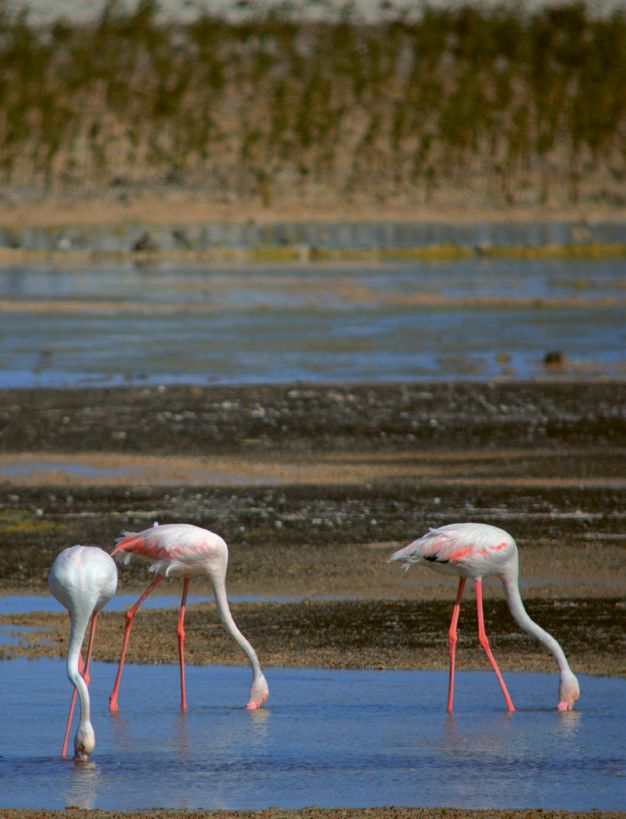
CONTRACTS

ADVERSE PHYSICAL
CONDITIONS
LEGAL DEVELOPMENT AND
CHANGES IN RISK PROFILES
6   TERRA ET AQUA
In marine infrastructure
                                                                                                      contracts, adverse
                                                                                                      physical conditions are
In the past decade, there have been noteworthy                                                        physical conditions
advances in case law with respect to adverse physical                                                 that could not be
conditions as well as the development and use
of digital ground models that have become more                                                        readily identified by
widespread. This article looks at the development and                                                 the contractor at the
changes in risk profiles that may result due to these                                                 time of tender.
two developments.

A decade ago, I co-authored an article in          Geological/Physical                   Anthropogenic                Natural/Hydrological Event
Terra et Aqua (Autumn 2005) titled ‘Adverse
                                                   Cobbles, boulders                     Anchors, wires, debris       Wave shoaling
Physical Conditions and the Experienced
                                                   Clay balls                            Ship wrecks                  Flash flooding
Contractor Test’. The article examined
                                                   Rock/cap rock/duricrust               Unknown foundations,         Earthquake liquefaction
the relationship between site inspection,          Particle size distribution            jet-ties, etc                Tsunami
foreseeability and adverse physical conditions     Internal angle of friction            Archaeological finds         Mudflows
and their incorporation in standard contracts      Density/unit weight                   Submarine cables             Scour
and their evolution over the years. The article    UCS/point load index                  Pipelines                    Coastal erosion
also looked at site investigation techniques       RQD/fracture index                    Pollutants
and the issues arising due to incomplete or        Mineralogy                            Unexploded ordnance
inaccurate data.                                   Compactness
                                                   Carbonate/shell content
What constitutes adverse physical                  H2S
conditions?                                        Groundwater levels
                                                   Ground settlement/consolidation
To recap from the original article, in marine
infrastructure contracts, adverse physical
conditions are physical conditions that could       FIGURE 1

not be readily identified by the contractor        Extract from Adverse Physical Conditions and the Experienced Contractor (Kinlan, 2014).
at the time of tender. When a contractor
encounters an adverse physical condition
during the execution of the project, they
may be entitled to an extension of time or         The definition of ‘unforeseeable’, as stated      test’ is applied. Variations of the principle
additional payments. The inclusion of an           in the Federation Internationale des              of a ‘test’ can be found in many standard
adverse physical conditions clause in most         Ingenieurs-Conseils (FIDIC) Red and Yellow        form construction contracts. Essentially,
standard forms of contract is to reallocate        Book (1999), is ‘not reasonably foreseeable       it is a comparison of what adverse physical
the risk for the consequence of encountering       by an experienced contractor by the date for      conditions were encountered and whether
such unforeseen adverse physical conditions        submission of the tender’. Some examples          they differ materially from those which
from the contractor to the employer. The           of adverse physical conditions are shown          could reasonably have been foreseen by
rationale for this approach is that the employer   in Figure 1.                                      an experienced contractor. The marine
only pays for those conditions actually                                                              construction industry has a significant
encountered and does not have to pay any           Experienced contractor test                       risk profile when compared to the wider
contractor’s price contingency for conditions      In determining whether a condition is adverse     sections of the construction industry.
that may not be encountered.                       and unforeseen, the ‘experienced contractor       The CRUX Insight 2020 investigation of

                                                                                                                  #162 - SPRING 2021                 7
CONTRACTS

                                                                                                       distributed information on soils to be dredged,
                                                                                                       disposed of (including disposal areas), used
                                                                                                       as reclamation materials and underlying
                                                                                                       the proposed reclamation area. A detailed
                                                                                                       investigation should be carried out before
                                                                                                       going out to tender.

                                                                                                       It goes on to state: When considering
                                                                                                       the time allowed for tendering and when
                                                                                                       considering the time and cost of carrying
                                                                                                       out site investigations, particularly marine
                                                                                                       investigations, the employer should note that
                                                                                                       in their own interests, compliance with this
                                                                                                       requirement is strongly advised.

                                                                                                       It is the authors’ observation that these sort
                                                                                                       of recommendations are either not fully acted
                                                                                                       on or are given lip service as the lack of good
                                                                                                       quality and adequately distributed information
 FIGURE 2                                                                                              on the site make-up still give rise to disputes.
Gibraltar with its original runway crossing.                                                           However, case law over the past decade has
                                                                                                       shown that the contractor should not just
                                                                                                       accept blindly the information it is given and
                                                                                                       totally rely on it to the exclusion of its own
131 infrastructure projects worldwide confirms       Contract developments in the                      independent assessment.
a nexus of entrenched causation factors              intervening years
behind disputes. Notably, restrictions on            Luckily, time does not stand still both in the    Court cases over the past decade
access to worksites and unforeseen physical          development of contracts and applicable           This article examines two decisions of the
– typically ground conditions being key              case law as well as reporting on such matters.    English Technology and Construction Court
infrastructure claims.                               There is much more reporting of disputes          in 2014 and 2015, firstly Obrascon Huarte
                                                     now and claims have been taken to the             Lain SA v Her Majesty’s Attorney General
At the time of the author’s original article in      courts and the decisions are made public          for Gibraltar [2014] EWHC 1028; [2014]
2010, there was very little guidance in the          for industry participants to consider. A key      BLR 484 (Obrascon) as well as Van Oord
way of case law, literature and publications         issue for the marine infrastructure industry      UK Ltd and SICIM Roadbridge Ltd v Allseas
on the vexing issue of the risk allocation for       remains the type and quality of the available     UK Ltd (OSR), in which the court applied the
foreseeability of adverse physical conditions        geotechnical information.                         experienced contractor test. In addition, in
in marine infrastructure projects. John Uff QC                                                         2011 there was also an Australian case on
reported in 2012, ‘It is indeed unfortunate that     In 2016, FIDIC released the Form of Contract      the application of the obligation to inspect
there is virtually no authority on the application   for Dredging and Reclamation Works, Second        the site, being the Supreme Court of New
of this difficult test.’ Contract users were left    Edition, known industry-wide as the FIDIC         South Wales’ decision in Walton Construction
to fend for themselves when it came to the           Blue Book. In the notes for guidance, which       Pty Ltd v Illawarra Hotel Company Pty Ltd
nuances of how site inspection, foreseeability       at 19 pages is longer than the contract itself,   NSWSC 534 (Walton).
and the entitlement to claim for adverse             it states in particular, that the employer
physical conditions interacted and to what           should supply the following information: Soils    Obrascon case
extent they interrelated.                            information: good quality and adequately          The Obrascon case in 2014 has been widely
                                                                                                       reported on. It involved a contract (using
                                                                                                       FIDIC’s 1999 Yellow Book) for the design and
                                                                                                       construction of a tunnel under the runway of
 A key issue for the marine infrastructure                                                             the Gibraltar airport.

 industry remains the type and quality of the                                                          Obrascon brought an adverse physical
                                                                                                       condition claim when the Government
 available geotechnical information.                                                                   of Gibraltar terminated their contract.
                                                                                                       Obrascon claimed the extent and amount of
                                                                                                       contaminated materials was not reasonably
                                                                                                       foreseeable by an experienced contractor at
                                                                                                       the time of tender.

8            TERRA ET AQUA
The site investigation report contained         the tunnel alignment), and foreseeably there        expect considerable contamination at the site
a number of borehole log and trial pit          would have been lead within the made ground.        and therefore made a greater allowance in
results, which indicated ‘made ground’                                                              removal of such material.
(i.e. man-made ground) of varying depths        Similarly, he referred to aircraft fuelling
between 1.0 m and 5.4 m, and non-uniform        activities on the site for over 70 years            With respect to the estimate of 10,000 m3
soil contamination results.                     and the location of a previous fuel farm            of contaminated materials contained in the
                                                and oil pipes close to the works, with such         environmental statement, Akenhead stated
In their claim for unforeseen adverse           information leading experienced contractors         that this was one person’s interpretation of the
physical conditions, Obrascon relied on         to have appreciated that there ‘could well be’      data and tenderers were bound to take that
details in the environmental statement          hydrocarbon or other oil derivatives in the soil.   assessment into account, but they remained
provided in the tender documents, which                                                             under a duty to make their own independent
estimated that the work would require removal   Akenhead stated that if these factors were          assessment of the physical conditions likely to
of some 10,000 m3 of contaminated material.     coupled with the tender requirement to              be encountered.
Obrascon claimed that the removal of            allow for 10,000 m3 of contaminated
much more contaminated material than that       material, in his judgment, any experienced          OSR case
described in the environmental statement        contractor tendering for the works would            This particular case refers to the claimants,
was not foreseeable.                            foresee that there would or at least could          a joint venture (JV) formed by Van Oord UK
                                                realistically be substantial quantities             Ltd and Sicim Roadbridge Ltd (together
When rejecting Obrascon’s claim,                of contaminated material, and that the              OSR), which made an adverse physical
Justice Akenhead stated: ‘The contractor        allowance of 10,000 m3 was only a ‘say’             conditions claim against Allseas UK Ltd. The
cannot simply accept someone else’s             figure. In terms of quantities, Akenhead did        claim was brought in the name of the JV but
interpretation of the data and say that is      not put a precise figure on what should have        only concerned the onshore work element
all that was foreseeable.’                      been foreseen, but commented that it would          in respect of the gas export pipeline, carried
                                                be ‘very substantially above 10,000 m3’.            out by the civil partner, Sicim Roadbridge Ltd
Akenhead noted that an experienced                                                                  (Sicim). Allseas was the head contractor for
contractor would not limit itself to the        Akenhead determined that an experienced             construction of gas pipelines for a gas field
soil investigation report and volume of         contractor would have not just blindly              development that formed part of the Total
contaminated material in the environmental      accepted the volume of contaminated material        Laggan-Tormore gas field development at
statement. Rather a contractor would have       mentioned in the environmental statement            Sullom Voe in the Shetland Islands, Scotland.
referred to the environmental statement         but would have also looked at the history of
containing references to the history and        the site. The site had previous been a runway,      The proposed route of the gas export pipeline
various historical maps (including the          a fuel farm and a rifle range and the material to   onshore was from the Shetland Gas Plant
contaminated land desk study showing            be excavated was all made ground. Therefore,        on the north-western coast to Firths Voe on
‘earthwork rifle butts’ present in 1869 along   an experienced contractor could reasonably          the eastern coast. The total length of the gas
                                                                                                    export pipeline onshore was ~5.7 km.

                                                                                                    Sicim contended that it originally intended
                                                                                                    to construct part of the pipeline by forming
                                                                                                    an 8-metre-wide stone road and laying the
                                                                                                    pipe in a trench excavated into the adjacent
                                                                                                    untreated ground. OSR claimed that because
                                                                                                    peat was encountered at greater depths
                                                                                                    than it could reasonably have foreseen, it
                                                                                                    was obliged to build a 13.5-metre-wide stone
                                                                                                    embankment and lay the pipe within the
                                                                                                    embankment.

                                                                                                    Sicim relied on a Mackintosh probe survey
                                                                                                    report. The Mackintosh probe is a test used
                                                                                                    to measure the depth of soft soils, including
                                                                                                    peat. The report was not a contract document.
                                                                                                    It showed similar depths of peat along the
                                                                                                    pipeline, varying up to 2 m in depth. Sicim
                                                                                                    claimed that in cases where the actual
                                                                                                    conditions were different to the survey
 FIGURE 3                                                                                           results, it was entitled to an adverse physical
Total E&P UK Laggan-Tormore gas field development. Photo © Total                                    conditions claim under the subcontract.

                                                                                                                 #162 - SPRING 2021                  9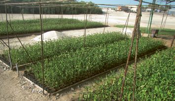
CONTRACTS

Increasingly, both         The head contractor had also carried out pre-        than a slab on ground, as indicated on the
                           contract trial pit logs, which showed peat at        drawings. The referee found that the void was
employers and              various depths at various locations, with some       an unforeseen condition under the terms of
                           of greater depth than the Mackintosh survey.         the contract. Illawarra challenged the referee’s
contractors are turning    Shortly after the contract was concluded the         finding on this issue.
                           head contractor provided a full topographic
to digital ground          and geophysical survey, including a resistivity      Justice Einstein set out the terms of the
                           survey, the results of which were consistent         contract that had an adverse physical
models to aid them         with the pre-contract trial pit information.         conditions clause similar to that in the FIDIC
                                                                                contract suite, and was of the view that the
in their understanding     With respect to the requirement that                 provision did not require an investigation of
                           subsurface conditions must be different              all potential aspects of physical conditions on
of their particular site   from those described in the subcontract              the site, but is limited to an inspection of the
                           documents, Justice Coulson found that the            site and its surroundings. He was of the view
and its unique             only subcontract documents that referred to          that what is reasonable in terms of inspection
                           the subsurface conditions were the contract          of the site is to be informed by the degree of
characteristics.           drawings, the purpose of which was to identify       information otherwise available to the tenderer,
                           the path of the pipeline. However, the drawings      which in this case, included the engineering
                           also referred to ‘the approximate depth of peat      drawings prepared by Illawarra’s structural
                           strata’ and showed many areas of peat greater        engineer, depicting a slab on ground. Illawarra’s
                           than 1 m or 1.5 m, and an area of peat 140 m in      evidence was that Walton inspected the site,
                           length of depth between 3 m and 5 m. Coulson         but did not get under the building and inspect
                           concluded the subsurface conditions were not         the subfloor conditions, since they believed
                           different from those described in the contract       that the architect and the engineer would have
                           documents and therefore, Sicim’s adverse             done this, resulting in the selection of the slab
                           physical conditions claim failed.                    on ground design.

                           Coulson rejected the supposition that Sicim          Einstein found that Walton did precisely what
                           was entitled to treat the Mackintosh report as       was required, examined the drawings and
                           a type of ‘guarantee’. Further stating that it is    inspected the site, and that the drawings did
                           a matter for contractors’ judgment as to the         not show the void, rather, to the contrary. He
                           extent to which they rely on the information,        concluded that an experienced contractor
                           referring to the decision in Obrascon, and           would not expect to find physical conditions in
                           as a matter of common sense that ‘every              the nature of the void, having regard to the very
                           contractor knows that ground investigations          drawings that the adverse physical conditions
                           are only 100% accurate in the precise                clause requires a contractor to examine.
                           locations in which they are carried out, and that
                           it is for an experienced contractor to fill in the   Einstein, in referring to Walton, was of the view
                           gaps.’ Coulson added that it was reasonable to       that an experienced contractor’s inspection
                           take an informed decision as to depths greater       of the site is to be ‘informed by the degree of
                           than 1.5 m in depth.                                 information otherwise available to the builder’.
                                                                                Einstein reasoning that he considered an
                           Walton case                                          experienced contractor would not have
                           There is an Australian case that is noteworthy,      accessed below the building and inspected
                           this being Illawarra Hotel Company Pty Ltd           the subfloor conditions, in light of having
                           (Illawarra) and Walton Construction Pty Ltd          examined the employer’s drawings showing a
                           (Walton). Illawarra entered into a contract          slab on ground.
                           for Walton to carry out the renovation and
                           refurbishment of its hotel. A number of matters      How such a decision would be interpreted
                           were referred for determination by a referee         for a marine infrastructure project throws up
                           one of which was on account of variations to         some interesting points. The author considers
                           the scope of work.                                   that this particular contractor’s failure to
                                                                                fully ‘inspect’ is inconsistent with the terms
                           One of Walton’s variations concerned the             of most adverse physical conditions clauses
                           unexpected discovery of a deep void in the           such as in FIDIC (1999 Red and Yellow Book)
                           foundation to the floor slab, which required the     clause 4.10, which specifies as an independent
                           construction of a suspended floor slab, rather       requirement that the experienced contractor

10     TERRA ET AQUA
shall, to the same extent as the contractor, latter, the contractor may have information well as the study of groundwater aquifers and
‘be deemed to have inspected and examined that the employer may not have provided, ore deposits.
the site, its surroundings and other available which has a bearing on the expected physical
information’, with the term ‘surroundings’ conditions at the proposed site. The spin-off from the use of geomodels in
not containing any limitation as to distance. the resource industry was their development
The author submits that the decision in When the tenderer compiles all the and application in other fields such as civil
Walton should not therefore be relied upon available data it needs to make sense of it engineering where various proprietary digital
by contractors as authority for the principle all in order to make an assessment of the ground model software has been developed.
that the experienced contractor test does not likely physical conditions and materials that Many geological survey organisations
involve a complete and thorough inspection may be encountered. Increasingly, both worldwide have started to implement varying
of the entire site and its surroundings, and employers and contractors are turning to software systems and methodologies to
that ‘surroundings’ in a marine environment, digital ground models to aid them in their facilitate a migration, from a 2D paper-based
whether immediate or in the area, need to be understanding of their particular site and survey to a 3D digital service provider of
considered when assessing the likelihood of its unique characteristics. geoscientific information. Rapid advances
encountering adverse physical conditions. in gaming technology has enabled a
Geomodels and digital ground models renaissance in digital ground modelling and
With respect to ‘other available information’ Geomodelling is the applied science of particularly in 3D visualisations. A Digital
mentioned in FIDIC (1999 Red and Yellow creating computerised representations of Ground Model (DGM) is a three-dimensional,
Book) it should be readily available and not the Earth’s crust based on geophysical and mathematical representation of the landform
buried away somewhere in an inaccessible geological observations and physical sampling and all its geological features, stored in a
archive. In the NEC4 ECC contract (2017) of materials both on and below the surface. computer database. A DGM is extremely
under clause 60.2 when judging physical A geomodel is the numerical equivalent useful in the design and construction
conditions, it refers to ‘publicly available of a three-dimensional geological map process, as it enables easy and accurate
information referred to in the site information’ complemented by a description of physical determination of the coordinates and
as well as ‘other information which an properties of the ground in the area of interest. elevation of any point and together with
experienced contractor could reasonably Geomodelling was developed with main referenced boreholes and samples allows an
be expected to have or to obtain’. So, for the applications to oil and gas, and mining fields as assessment of the likely soil or rock types
FIGURE 4
Vertical geological section of the metro tunnel at Sydney harbour. Aquares resistivity survey data has been inserted into the project IDGM allowing
vertical sections to be exported to GIS/CAD, Google Earth, Augmented Reality and holographics.
#162 - SPRING 2021 11CONTRACTS
that may be encountered between These advanced geophysical methods
sample locations. are digital and allow for determination of
thickness and depth of geological layers
The DGM is formed by integrating a as well as layer and intra-layer information
hydrographic survey of the surface with from the one sensor. Sensor intervals are
geophysical methods and sampling points better than one per second make it possible
under the seabed (using borehole log data to collect large volumes of high-resolution
and sample testing), and using appropriate data in a short period of time. The objective
algorithms to process these points to is to understand subsurface complexities in
represent the surface being modelled. detail at a site, which makes it possible to then
target boreholes to illuminate any observed
Geophysical methods are broadly broken geological anomalies.
into quantitative and qualitative methods.
Quantitative geophysics are reflection based Advanced geophysical methods
seismic methods. They are used to define Over the past decade advanced resistivity
depth to layer, but cannot be used to resolve technology has been improved upon which
quality variation between or within layers. enables the capture of high-resolution
Qualitative geophysics, usually seismic quantitative and qualitative information
refraction or resistivity methods, are used to about the strata under a site. Quantitative
define structural variation in the geology at a data includes depth and thicknesses of
site. Refraction methods do not readily resolve sub-bottom structures. Qualitative data
the level and depth of structures or complex includes type of sediment; sand, silt or clay
geology due to technical limitations. Another and rock characteristics such as fresh
approach relies on resistivity methods that or weathered. High resolution combined
are designed to quickly acquire large volumes quantitative and qualitative data is
of high-resolution data about the structural extremely useful as an aide for successful
geology over a large area. project planning. With this information
FIGURE 5
Borehole and geophysical data combined (Verhoef, 1997).
12 TERRA ET AQUAApplication Scope of work Penetration (m) Sample testing
Lowering seabed Number of boreholes strongly depends on risk Slightly deeper than level of Classification tests to find the
involved with ground variations . Bates (1981) required lowering of seabed. basic soil and rock parameters.
suggested 3 + A0.5.D0.33/50, where A is area in
m2 and D is average thickness of material to be Additional laboratory tests
removed in metres. depending on the need for
Samples & SPTs every 2 m with at least one in additional parameters.
each layer.
Some (P)CPTs if undrained shear strength (clay)
and/or relative density (silt and sand) is relevant.
Slope stability 1 borehole (samples & SPTs every 2 m, with at 0.5 x the slope height below
least one in each layer) or (P)CPT per 100 m. required level of lowering of seabed.
(P)CPT especially relevant in case of silt or sand
and relatively steep slope.
Fill material Number of boreholes strongly depends on To depth of potential fill material.
expected ground variations, with a minimum of
three required.
Settlement and Number of boreholes or (P)CPTs strongly 1x to 3x reclamation height
stability of subsoil of depends on risk involved with ground variations, depending on risk involved with
reclamation area e.g. one borehole (samples & SPTs every 2 m, with influence of deeper layers.
at least one in each layer) or (P}CPT per 1000 m2
to a minimum of three per 10000 m2.
FIGURE 6
Typical scope of geotechnical investigation for dredging.
project planners and engineers have a structural setting is problematic for two Site investigation
complete picture of the existing subsurface reasons. Firstly, as point source data, the
environment. This allows designs to take geologist has very little geological context to boreholes are critical
into account subsurface structures such as assist in the understanding and classification
weathered and unweathered rock outcrops or of, particularly deeper, layers as they relate to for the acquisition of
buried river valleys to considerably reduced a project site. Secondly, and most importantly,
dredging and construction costs. it is not statistically possible to demonstrate engineering data about
that a sampling pattern has adequately
Advanced geophysical methods are defined sampled all the materials that may be present a specific soil and rock
as geophysical methods with capabilities on a project site.
to acquire both quantitative and qualitative types, but fall short
information of the subsurface, presented in a The latter is a problem inherent in the marine
georeferenced 3D model to integrate all sorts infrastructure industry whereby borehole when used to infer
of other information including bathymetry, locations are not targeted but may be
boreholes, Standard Penetration Test, side randomly chosen or even restricted due to geological structures.
scan sonar, seismic, infrastructure and 3D budget constraints. There is little in the way of
surfaces (e.g. top of rock). The accuracy and guidance or recommendations as to borehole
resolution of advanced methods however, sampling patterns and spacing.
varies widely with outcomes dependent on
the resolution and data sampling density. The publication ‘Geotechnical and Geophysical
Site investigation boreholes are critical for Investigations for Offshore and Nearshore
the acquisition of engineering data about Developments’ (Kinlan, 2005) recommends
a specific soil and rock types, but fall short the scope of geotechnical investigation for
when used to infer geological structures. dredging as shown in Figure 6.
Utilising only boreholes as a primary data The publication contains the caveat: More
source to derive the entire project site’s boreholes or (P)CPTs may be required
#162 - SPRING 2021 13CONTRACTS
Modern DGM practice near anomalies or near discontinuities in It is precisely the ‘gaps’ and extrapolation
the soil layering, especially if a type of rock between borehole locations and the degree of
is increasingly seen or soil is present that cannot be excavated, variation between these data points that need
raised or transported with the proposed to be assessed and to which the experienced
as essential for dredging equipment, or if another high contractor test will apply.
risk is involved.
marine infrastructure Conclusion
In Obrascon, with reference to boreholes, The use of DGM is proving invaluable in the
planning and asset Justice Akenhead made the following assessment of a project site. Modern DGM
remark: ‘Most civil engineering tenderers practice is increasingly seen as essential
management. are aware that boreholes and trial pits for marine infrastructure planning and asset
only sample what is within the 100 mm management. Advanced remote sensing,
or 150 mm tube or 2 or 3 m2 trial pit. sophisticated digital data acquisition and
Particularly in made or contaminated management tools that are now available,
ground, it is difficult to extrapolate what compared to just a decade ago, help to reduce
may lie between the boreholes and pits. It the risk of unforeseen adverse physical
is easier to extrapolate in relation to the conditions that cause delay and significantly
natural ground profiles of the underlying increase the cost of marine infrastructure
soil or rocks.’ projects. Advanced digital geophysics provides
a reliable source of 3D data that can be
As Justice Coulson stated in the OSR integrated into an integrated ground model to
case: ‘Every experienced contractor knows provide engineers with a digital tool to manage
that ground investigations can only be and control risks relating to unforeseen and
100% accurate in the precise locations adverse physical conditions.
in which they are carried out. It is for an
experienced contractor to fill in the gaps This has become ever more relevant given the
and take an informed decision as to what development in case law and the Obrascon
the likely conditions would be overall.’ and OSR court cases have developed the
Summary
In the past decade, there have been noteworthy advances in
case law with respect to adverse physical conditions as well as
the development and the use of digital ground models that have
become more widespread. Advanced digital geophysics provides
a reliable source of 3D data that can be integrated into an
integrated ground model to provide engineers with a digital tool
to manage and control risks relating to unforeseen and adverse
physical conditions. This has become ever more relevant given
the development in case law and the Obrascon and OSR court
cases, which have developed the concept of the experienced
contractor test to a new level. The contractor has the burden
of satisfying the experienced contractor test on the balance
of probabilities and cannot solely rely on the Employer’s Site
Data alone as a sort of guarantee, and this is implicit from the
decisions of Obrascon and OSR.
14 TERRA ET AQUAconcept of the experienced contractor test high-resolution data about the structural GBR can be used to decide if the conditions
to a new level. These cases have shown that geology over the project area. This can were really unforeseeable and or fall within the
an experienced contractor at tender stage be completed in a matter of days. It has conditions expected at the site.
cannot simply limit itself solely to an analysis to be said however, that the employer is
of the geotechnical information contained in best placed to do this at pre-tender phase
the pre-contract site investigation report and and provide the geophysical information
the underlying sampling. it obtains to all tenderers rather than
multiple tenderers carrying out such
The statement in the OSR case that, ‘it is for an exercise. It should be noted that the
an experienced contractor to fill in the gaps requirement to have ‘inspected’ the site
and take an informed decision as to what is a lesser standard than a requirement to
the likely conditions would be overall’, sets ‘examine’, ‘verify’ or ‘investigate’ the site
the basis for the test as to what should be so contractors should be cautious if such
reasonably expected from an experienced wording is used in any contract.
contractor. The contractor has the burden of
satisfying the experienced contractor test on Lastly, in the event of anticipated complex
the balance of probabilities and cannot solely geotechnical conditions on a marine David Kinlan
rely on the employer’s site data alone as a infrastructure project, employers may David is a Marine Contracts Manager with
sort of guarantee, and this is implicit from the consider the recommendation in FIDIC’s Blue 35 years of experience in the global maritime
decisions of Obrascon and OSR. Book (2016) note for guidance on addressing and civil engineering industry as a consultant
the foreseeability of those conditions by specialising on contract appraisals, contract
Increasingly, potential tenderers will be using a Geotechnical Baseline Report (GBR) administration, preparation of variations,
expected to interrogate the available as a reference. A GBR would set out what claims and adjudication of payment
source data. If there is any perceived lack of the expected ground conditions on a project disputes. Author of the book Adverse
geotechnical data between boreholes, they will be and in effect create a specification Physical Conditions and the Experienced
could use (as part of their site ‘inspection’) for the anticipated conditions. In the event Contractor, David is a registered adjudicator
geophysical resistivity methods that are of the project running into difficulties due to in Queensland, Australia under security of
designed to acquire large volumes of unforeseen adverse physical conditions, the payment legislation.
REFERENCES
Crux Insight 2020 Report: Engineering and Construction – Kinlan D. (2005)
A Regional Analysis of Causation, Lessons Learned from Claims Geotechnical and Geophysical Investigations for Offshore and
and Disputes. Published by HKA. Nearshore Developments. Terra et Aqua, #119, Autumn 2005.
https://www.hka.com/2020-crux-insight/ https://www.iadc-dredging.com/publication/geotechnical-
geophysical-investigations/
Federation Internationale des
Ingenieurs-Conseils (FIDIC) (2016) Kinlan D. (2014)
Form of Contract for Dredging and Reclamation Works, Second Adverse Physical Conditions and the Experienced Contractor,
Edition (2016 Blue Book). Delft Academic Press, Delft, The Netherlands.
Federation Internationale des NEC (2017)
Ingenieurs-Conseils (FIDIC) (1999) NEC4 Engineering and Construction Contract, Thomas Telford Ltd,
Conditions of Contract for Construction for Building and London, United Kingdom.
Engineering Works designed by the Employer, First Edition (1999
Red Book). Verhoef P. (1997)
Wear of rock cutting tools. Implications for the site investigation
Federation Internationale des of rock dredging projects.
Ingenieurs-Conseils (FIDIC) (1999) Delft University of Technology, Faculty of Applied Earth Sciences,
Conditions of Contract for Plant and Design-Build, First Edition Section of Engineering Geology, Delft, The Netherlands. Published
(1999 Yellow Book). by A.A. Balkema, Rotterdam, The Netherlands.
#162 - SPRING 2021 15ENVIRONMENT CREATING MANGROVE HABITAT FOR SHORELINE PROTECTION WORKING WITH NATURE IN THE ARABIAN GULF 16 TERRA ET AQUA
Mangroves require
sheltered conditions
for their initial
Over the past decades, there has been a growing establishment, but
interest in exploring innovative ways to minimise the once well established
environmental footprint of coastal developments
and in nature-based approaches for shoreline provide effective
protection. At Mubarraz Island near Abu Dhabi (UAE), protection from
an international oil company beneficially reused shoreline erosion.
~12 million m3 of dredged material to protect pipelines,
construct a causeway and create mangrove habitat
to manage coastal erosion. This ‘Working with Nature’
approach has provided a cost-effective nature-based
solution for shoreline protection, with added benefits
for biodiversity conservation.
Mubarraz Island typical speeds of 7 m s-1 (northern wind) during north-west direction (known locally as ‘shamals’)
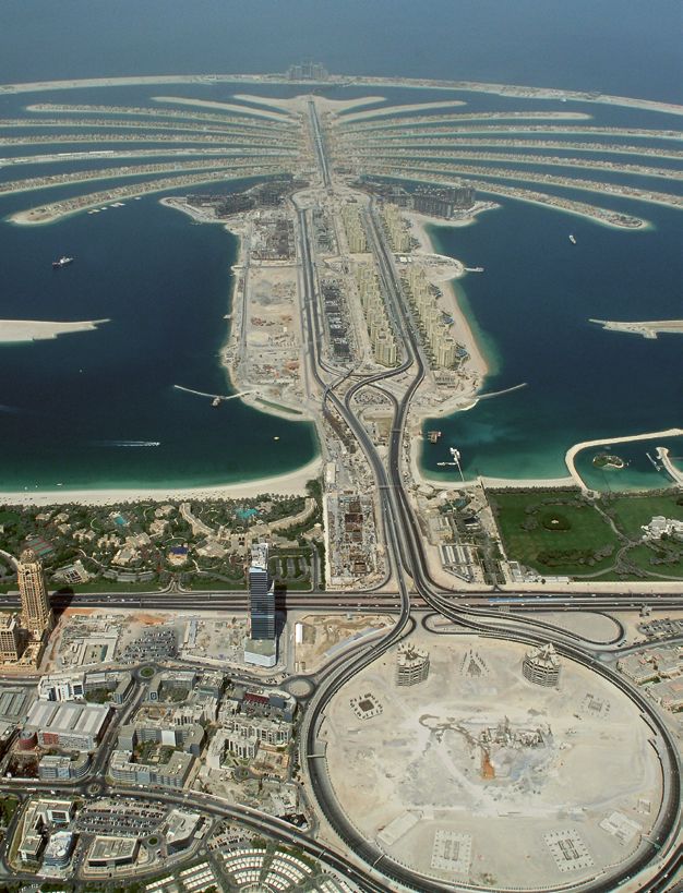
Mubarraz Island is located in the Arabian the day and 6 m s-1 (southern wind) at night. can occur during winter storms. Average annual
Gulf, some 100 km north-west of Abu Dhabi Much stronger winds (up to 12 m s-1) from the rainfall in this arid region is 90 mm year-1.
in the United Arab Emirates. The island is
surrounded by a large (165 km2) sandy shoal
(up to 5 m deep) with extensive seagrass
meadows and fringing reefs. Mubarraz A B
shoal features several oil fields (mostly
situated in the northern parts of the shoal),
that are under concession by a Japanese
oil company, Abu Dhabi Oil Co. (Japan)
Ltd since the 1970s. Mubarraz is subject
to extreme climatic and environmental
conditions typical of the arid Arabian Gulf
region. Soils and marine sediments are
predominantly calcareous sands that are
poor in nutrients and organic matter. Surface
water temperature on the shoal ranges
from 17–21°C in winter and from 31–35°C in
summer, but can locally reach up to as high
as 40°C in sheltered shallow areas. Salinity is
high and typically ranges from 40–48. Water
levels are governed by a diurnal tide with a
maximum tidal amplitude of 2.3 m. Maximum
tidal currents across the shoal are generally
lower than 0.5 m s-1. Average wind conditions FIGURE 1
are governed by land and sea breezes with Mubarraz (Landsat satellite image) in 1972 (A) and (EOMAP satellite image) in 2018 (B).
#162 - SPRING 2021 17ENVIRONMENT
FIGURE 2
Aerial view of the
northern section
of the Mubarraz
causeway.
Dredging and causeway construction reclamations at the production wells and along of the causeway and enhance connectivity,
During 1983–85, a navigation channel the island. providing opportunity for the exchange of
was dredged across the shoal to facilitate water, organisms and larvae.
navigational access. The main navigation There are no historical records of
channel extends from north to south, environmental impacts of the construction of Mangrove planting
branching out with several extensions in the the causeway (early 1980s), but more recent The first mangrove planting campaigns at
north, totalling 31 km in length. The channel is environmental assessments describe the Mubarraz were carried out during the start-
125 m wide and 6–7 m deep (i.e. some 3 m marine ecosystems at Mubarraz as being in up phase of causeway construction and oil
deeper than adjacent seabed), and its good health (Deltares, 2006; DOME, 2007). operations during 1983–87. These plantings
excavation resulted in a total volume of Remote sensing analysis suggests that the were conducted with seedlings of the
approximately 12 Mm3 of carbonate sediment, seagrass meadows, which cover approximately mangrove species Avicennia marina obtained
consisting mostly of sand (70%), with 22% 4,000 hectares of the shallow waters of from a mangrove tree nursery in mainland
gravel and 8% fines (Aces, 2016). Mubarraz shoal, recovered well in the years Abu Dhabi, along with some propagules
following the completion of dredging and of Rhizophora stylosa (from Pakistan),
Approximately 10 Mm3 of this dredged causeway construction, having fully recovered Rhizophora mucronata (from Malaysia) and
material was used for the construction of a by 1990 (DAMCO Consulting, 2018). The Ceriops tagal (from Thailand). The primary
17-kilometre-long causeway that protects seagrass beds at Mubarraz support significant focus of these early planting efforts was
several oil pipelines and power cables, and populations of green turtles (Chelonia mydas), environmental enhancement (‘greening’),
serves as a road connection between the dugongs (Dugong dugon) and humpback implemented at numerous locations, being
oil production areas and the main island. dolphins (Sousa plumbea). Coral reefs around only successful with Avicennia marina in
The causeway is 50–150 m wide and has a Mubarraz shoal suffered multiple bleaching sheltered corners of the causeway and island,
‘height’ of 5.1 m above the adjacent seabed events in 1996, 1998, 2002 and 2017 due showing very low survival with the other
or approximately 3.3 m above mean sea level to thermal stress related to climate change species and at other locations.
(MSL), assuming average water depth near the and are now in a poor condition similar to
causeway to be in the order of 2.8 m, and MSL most reefs in the southern Gulf (Burt et al., Following increasing shoreline erosion along
being 1.2 m above Chart Datum. The remaining 2019). Two culvert gaps were constructed the western side of the causeway in the
~2 Mm3 of dredged material was used for land in 2007 to reduce perceived barrier effects mid-2000s, a new ‘Working with Nature’
18 TERRA ET AQUAapproach was adopted for the mangrove A tree nursery was established at the
planting works. A tree nursery was
established under the shade of trees at the south-western edge of the main island
south-western edge of the main island with
a capacity of 80,000 seedlings. Nursery with a capacity of 80,000 seedlings.
practices followed general guidelines from
international best practice manuals, further
optimised over time according to what
worked best under local conditions.
Propagules to seed the pots in the nursery
are collected annually over a two-week period
in mid-September from mature mangrove
stands on Mubarraz, obtaining best results
with three propagules planted per pot in a
soil mixture of sand, peat moss and plant
potting mix. Seedlings are watered and
nurtured in the nursery for approximately
six months until they are large and strong
enough to be planted in the field. A site survey
in March 2005, assisted by satellite imagery
analysis, was conducted to guide site
selection for new mangrove planting efforts.
At the start of the program in the
mid-1980s, most planting was done in a
random fashion along the outer shorelines
of the causeway and island without any
specific site preparation. Although this yielded
reasonable success at some sheltered
locations in the north-west corner of the
causeway (at West Mubarraz), most initial
planting efforts along the exposed stretches FIGURE 3
of the causeway failed completely. Mangrove tree nursery on Mubarraz Island.
FIGURE 4
Planting mangrove seedlings inside a tidal channel.
#162 - SPRING 2021 19ENVIRONMENT
FIGURE 5 FIGURE 6
Excavation of tidal channels along causeway. Completed tidal channel prior to planting.
Channels were
dug to a depth
considered suitable
for mangrove growth.
FIGURE 7
Aerial view of causeway, tidal channels and navigation channel.
Map data: Google, image © 2020 Maxar Technologies.
Therefore, an alternative approach had to of seawater with the tide and varied in length protected from wave action and seagrass
be developed here to provide the plantings fromhave been planted at 1 m spacing, covering
different areas each year. By 2019, a total
of ~500,000 seedlings had been planted.
Plans for the coming years are to continue
planting more mangroves, wherever possible,
until most of the shoreline of the causeway is
fringed on both sides by a protective belt of
mature mangrove vegetation.
A recent assessment of the overall success
of the mangrove planting program at
Mubarraz revealed survival rates of planted
mangroves (from seedling to mature trees)
to be in the order of 26% (averaged over
all years), with well-established mangrove
vegetation (totalling some 140,000 trees
and saplings) now lining approximately
7 km of shoreline, covering 16.5 hectares
(Erftemeijer et al., 2020). Successfully
planted stands of mangroves were FIGURE 8
characterised by high tree density (mean: Monitoring survival and growth of planted mangroves.
8838 trees ha-1), stunted tree height
(mean: 3 m), narrow stem diameter (mean:
5 cm), moderate basal area (5–37 m2 ha-1),
mean pneumatophore density of 589 m-2, Colonisation by fauna reuse of dredged material, and successful
and healthy recruitment (>14,000 natural Established mangrove stands have been establishment of mangrove vegetation,
seedlings ha-1) (Erftemeijer et al., 2020). The successfully colonised by benthic invertebrate previously absent from Mubarraz. At least six
overall survival of 26% (or 32% if recently fauna, as indicated by high densities of crab of these bird species have been confirmed to
planted seedlings are included) of all planted holes (up to 638 m-2) and gastropod snails breed on the island, owing to the presence of
seedlings at Mubarraz is comparable to (up to 429 m-2). Mubarraz currently supports the mangrove vegetation, while several others
natural survival rates for mangrove seedlings a significant diversity of birds with 50 species (including 12 shorebird species) visit the island
in the field, as reported in the general recorded to date. This can be attributed almost during the migratory season. The oil company
literature (see Erftemeijer et al., 2020). entirely to the creation of new land, by the also facilitated the construction of 12 artificial
A B
FIGURE 9
Impressions of various recent (A) and older (B) mangrove plantings in tidal channels behind protective berms along the causeway.
#162 - SPRING 2021 21ENVIRONMENT
Mubarraz currently
supports 50 species
of birds, which can
be attributed almost
entirely to the
creation of new land
and successful
establishment of
mangrove vegetation.
nesting facilities for Ospreys that are being at Mubarraz corresponds to channel bed material separating the channels from the sea
used for breeding every year by multiple pairs levels of 27–42 cm above MSL, have been have gradually eroded away. Meanwhile, a few
of this impressive fish-eating bird of prey generally successful. Sites inundated for more critical stretches of the causeway’s shoreline
(with maximum daily counts of 21 birds). than 500 minutes per day were generally have been protected with sheet piling. The
These observations suggest a significant unsuccessful, apparently exceeding the costs of such hard engineering solutions,
level of faunal colonisation of the artificially mangroves’ tolerance limit for waterlogging, which require maintenance and have a limited
created mangrove stands on an island that did leaving them insufficient time at low tide to lifespan, were six times more expensive than
not have any vegetation before, underscoring bring enough oxygen back into the soil through the costs of the mangrove planting approach.
the importance of the planted mangroves for their breathing roots for survival. These This clearly underscores the potential cost-
biodiversity conservation. site-specific findings are now being used effectiveness of nature-based solutions
to guide the design of new channels and such as the use of mangrove vegetation
Hydrological investigations and modify the depth of unsuccessful (existing) over conventional engineering approaches
channel modification channels to further optimise replanting for shoreline protection. Similar findings
New plantings along a further 9 km of the success at Mubarraz. were reported by Winterwerp et al. (2016)
causeway’s shoreline are currently underway. who successfully restored mangroves as a
The bed levels in some tidal channels had Shoreline protection cost-effective sustainable climate-adaptive
to be adjusted in order to provide optimal The protective berms of dredged material solution to reverse severe coastal erosion
tidal inundation conditions for these new along the mangrove channels occasionally along the north coast of Java, Indonesia, with
plantings, based on detailed hydrological required maintenance to repair sections associated socio-economic benefits for the
investigations in 2019 (DAMCO Consulting, affected by storm damage. Following planting, local community.
2020) following recommendations described the young mangrove vegetation will not offer
in Van Loon et al. (2016). Using water level much shoreline protection initially, but as Beneficial reuse of dredged material
loggers (complemented with auto-levelling the mangrove stands develop and expand for mangrove habitat
measurements), the daily duration of tidal over the years, they can substantially reduce There are other examples similar to the
inundation at successful and unsuccessful wave height and energy, and contribute to work showcased here for Mubarraz Island.
planting sites were measured to establish protection from erosion, depending on tree The last few decades have seen a rise in
the relationship between planting success density, stem diameter and the density of such beneficial use application of dredged
and hydrological conditions (tidal inundation their pneumatophores. It is expected that material for the rehabilitation and creation
as function of bed level relative to MSL). The over the coming decade, these mangroves of coastal wetlands worldwide (Turner and
results of these hydrological investigations will have grown and established themselves Streever, 2002). Particularly in the USA
indicated that mangrove planting efforts sufficiently enough to withstand significant (largely through the work of the US Army
at sites that experience tidal inundation wave energy and protect these shorelines from Corps of Engineers) there is a considerable
between 180–450 minutes per day, which erosion after the protective berms of dredged body of well-documented experience with
22 TERRA ET AQUAand engineered to correct tidal positioning
with an excavated system of artificial tidal
creeks. Initial mangrove test plantings all died
as the fresh mud was too acidic, but after
a delay of four months to let the seawater
neutralise the soil pH, the two areas were
successfully planted with 400,000 mangrove
seedlings (Chuan, 2009). There are similar
sites at Lake Maracaibo in Venezuela (Pannier
and De Pannier, 2008) and at Navachista
Bay and Chiapas lagoon in Mexico (Chargoy
and Hernández, 2002), all involving dredged
FIGURE 10 FIGURE 11 material deposits that were either actively
Mangrove planting on Mubarraz Island The same mangrove planting on Mubarraz planted with mangroves to help stabilise the
photographed in 1984. Island photographed in 2009. deposits or colonised naturally over time.
More recently, there is also an increasing
attention to explore nature-based approaches
the establishment of ‘dredged material of natural succession and are often used by to coastal protection from climate-change
wetlands’, i.e. the intentional restoration or waterbirds for breeding (Lewis and Lewis, related threats worldwide (Mink and
creation of wetlands using dredged material, 1978). Two larger dredged spoil islands south Sansoglou, 2020), including the Gulf region
both in freshwater/estuarine and coastal/ of Alafia River mouth (Florida), which initially (Burt and Bartholomew, 2019). These form
marine environments (Bridges et al., 2018). It functioned as dredged spoil disposal facilities, part of a wider paradigm shift in the waterborne
is important to note that few dredged material were later planted with marsh grass (Spartina) infrastructure development industry that are
wetlands would be built if there was no need to and colonised by mangroves and are now inspired by larger initiatives such as ‘Working
dispose of material resulting from navigation- managed as a bird sanctuary, hosting more with Nature’ by PIANC (www.pianc.org/
related dredging operations. than 12,000 breeding pairs of 20 waterbird working-with-nature), ‘Building with Nature’
species (Robin Lewis III, pers. comm., 2017). in the Netherlands (www.ecoshape.org; Van
In Florida, more than 250 spoil islands In Singapore, two new mangrove areas Eekelen and Bouw, 2020) and ‘Engineering
(1–2 hectares each) from historic dredging encompassing a total area of 13 hectares were with Nature’ in the USA (https://ewn.el.erdc.
operations (1930–1970) at the Indian River, created on dredged material to compensate dren.mil; Bridges et al., 2018). A variety of
Yankee Town, Pitchlacha-scotee Rover, Tampa for the loss of habitat due to the construction innovative projects implemented under these
and Caloosahatchee River, were naturally of an offshore landfill site at Pulau Semakau programmes also involved the beneficial
colonised by mangroves, saltmarsh and (Chuan, 2009). The site was protected by a reuse of dredged material from capital or
terrestrial vegetation, following processes rock perimeter bund, underlain with geofabrics, maintenance dredging operations.
FIGURE 12 FIGURE 13
Aerial view of mangroves along a channel at Mubarraz Island Mangroves adjacent to oil infrastructure
(protecting infrastructure). at West Mubarraz.
#162 - SPRING 2021 23You can also read