2023 KANSAS SEVERE WEATHER AWARENESS - SEVERE WEATHER AWARENESS WEEK TORNADO SAFETY DRILL
←
→
Page content transcription
If your browser does not render page correctly, please read the page content below

2023 KANSAS
        SEVERE WEATHER AWARENESS
             Information Packet

SEVERE WEATHER AWARENESS WEEK
         March 6-10, 2023

     TORNADO SAFETY DRILL
       Tuesday, March 7, 2023
        10AM CST/9AM MST
     KANSAS SEVERE WEATHER AWARENESS WEEK
                MARCH 6-10, 2023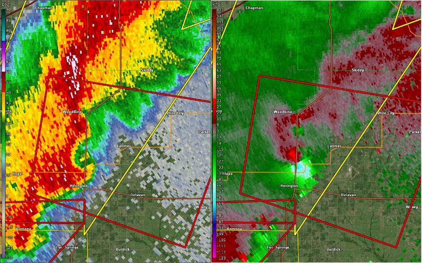
Table of Contents
                                                                      Page Number

2022 Kansas Tornado Overview                                               3
Kansas Tornado Statistics by County                                        4
Meet the 7 Kansas National Weather Service Offices                         6
2022 Severe Summary for Extreme East Central and Northeast Kansas          7
            NWS Pleasant Hill, MO
2022 Severe Summary for Southeast Kansas                                   8
            NWS Springfield, MO
2022 Severe Summary for Northeast and East Central Kansas                  9
            NWS Topeka, KS
2022 Severe Summary for North Central Kansas                              11
            NWS Hastings, NE
2022 Severe Summary for Central, South Central and Southeast Kansas       13
            NWS Wichita, KS
2022 Severe Summary for Southwest Kansas                                  15
            NWS Dodge City, KS
2022 Severe Summary for Northwest Kansas                                  17
            NWS Goodland, KS
Weather Ready Nation                                                      18

                   KANSAS SEVERE WEATHER AWARENESS WEEK
                              MARCH 6-10, 2023
                                         2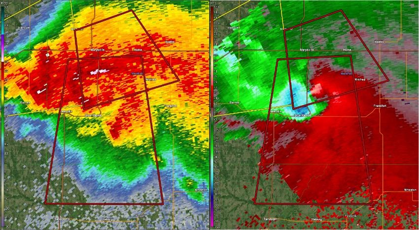
2022 Kansas Tornado Overview
Tornadoes:          56         5 below the 1950-2022 average of 61
                               29 below the past 30 year average of 85
                               11 below the past 10 year average of 67

Fatalities:         0          Injuries: 3
Longest track:                 21.76 miles (Dickinson/Morris, April 29, EF1)
Strongest:                     EF3 (Sedgwick/Butler, April 29)
Most in a county:              8 (Thomas)
Tornado days:                  17 (Days with 1 or more tornadoes)
Most in one day:               14 (April 29)
Most in one month:             22 (June)
First tornado of the year: March 29 (Jefferson Co., 6:56PM CST, EF1, 9.86 mile length, 10 yard width)
Last tornado of the year: Aug 29 (Ford Co., 3:29PM CST, EF0, 1.72 mile length, 30 yard width)
Length of tornado season: 154 days (Days between first and last tornado)

                         2022 Monthly Tornado Totals
 Month        Jan        Feb    Mar     Apr       May       Jun          Jul   Aug       Sep      Oct      Nov      Dec     Total
   EF5         0          0      0         0        0        0           0       0         0        0       0        0        0       0%
   EF4         0          0      0         0        0        0           0       0         0        0       0        0        0       0%
   EF3         0          0      0         1        0        0           0       0         0        0       0        0        1      1.8%
   EF2         0          0      0         0        0        1           0       0         0        0       0        0        1      1.8%
   EF1         0          0      1       11         0        8           0       0         0        0       0        0        20    35.7%
   EF0         0          0      0         4        2        4           0       1         0        0       0        0        11    19.6%
Unknown        0          0      0         3        5        9           6       0         0        0       0        0        23    41.1%
  Total        0          0      1       19         7        22          6       1         0        0       0        0        56    100%
 Percent 0.0% 0.0% 1.8% 33.9% 12.5% 39.3% 10.7% 1.8%                                    0.0% 0.0% 0.0% 0.0%
 Violent (EF4—EF5) in red, Strong (EF2-EF3) in yellow, Weak (EF0-EF1) in green, Unknown in orange. Monthly totals in gray. Tornadoes not
     causing damage ranked as unknown due to insufficient data to assign a rating. (Percent values may not add to 100% due to rounding)

 Annual Highlights: The 2022 tornado season was more active than the previous two years combined for
 the state of Kansas. A total of 56 tornadoes were recorded during the year, up from 37 tornadoes in 2021
 and 17 tornadoes in 2020. The strongest tornado reported in Kansas during the 2022 season was an EF-3
 occurring in Sedgwick and Butler counties on April 29th. The tornado initially formed in Sedgwick County
 causing damage to a manufactured home and injuring two occupants; estimated damages were placed at 4.5
 million dollars. This tornado then crossed into Butler County where it further strengthened into an EF-3 re-
 sulting in around 37 million dollars in damage and one injury. In total, 14 tornadoes occurred during the April
 29th outbreak across the state of Kansas.

 Despite the large number of tornadoes from the 29th, June recorded the most Kansas tornadoes with 22. Of
 the June tornadoes, seven occurred on June 11th and another six were reported from storms on the 23rd. The
 longest tornado track for the year was 21.76 miles where the tornado developed in Dickinson County and
 traveled 6.8 miles before crossing into Morris County. The tornado continued another 14.96 miles bringing
 damage to several farmsteads before dissipating near Parkerville.
                              KANSAS SEVERE WEATHER AWARENESS WEEK
                                               MARCH 6-10, 2023
                                                                     3
Kansas Tornado Statistics
                                           by County
                                      1950 - 2022
                          TORNADOES, FATALITIES, AND INJURIES

                          Legend: Tor = Tornado | Fat = Fatalities | Inj = Injuries
  County     Tor   Fat     Inj      County       Tor     Fat     Inj       County       Tor    Fat    Inj

   Allen     27     0      4      Greenwood       47       0      18        Pawnee      54      0     1
Anderson      15    3      12      Hamilton       33       0       1        Phillips    41      0     1
Atchison      16    0      11       Harper        64       0       1     Pottawatomie   37      1     5
 Barber       41    0       2       Harvey        50       1      63          Pratt      74     3     10
 Barton      107    2      40       Haskell       33       0      10        Rawlins      51     0      4
Bourbon       19    0       7     Hodgeman        59       0       4         Reno        87     0     22
 Brown        46    0       5      Jackson        34       4      17
 Butler       90   28     226                                              Republic      63     0      3
                                   Jefferson      42       0     101          Rice       50     0      6
 Chase        41    0       2       Jewell        43       0       2         Riley       32     0     51
Chautauqua   21     0      0       Johnson        46       0      12
                                                                             Rooks       53     0      6
 Cherokee    41     4     66        Kearny        46       0       0
                                                                             Rush        53     0      8
                                   Kingman        67       0       1
Cheyenne     46     0      0                                                Russell      81     1      7
                                     Kiowa        61      11      74
   Clark     42     0       0                                                Saline      48     0     66
                                    Labette       43       1      29
   Clay      45     1      31                                                Scott       58     1      1
                                     Lane         48       0       2
  Cloud      52     1       8                                              Sedgwick      90    13    362
  Coffey     24     0       5    Leavenworth      31       2      30
                                                                            Seward       39     0     15
Comanche     44     0       2       Lincoln       35       0       2
                                                                           Shawnee       56    18    528
  Cowley     85    77     293         Linn        14       0       3
                                                                           Sheridan      45     0      0
 Crawford    37     4      43       Logan         35       0       0
                                                                           Sherman      114     0      0
 Decatur     51     0       5        Lyon         50       7     222
                                                                             Smith       45     0      2
Dickinson    43     1      17       Marion        51       1       2
                                                                            Stafford     73     3      5
                                   Marshall       41       0       1        Stanton      24     0      0
 Doniphan     20    0      2
                                  McPherson       55       1      16
 Douglas      43    1     64                                                Stevens      25     1      5
                                    Meade         57       0       0
 Edwards      56    0      7                                                Sumner       88     5     14
                                     Miami        23       4      10
     Elk      26    2      8                                                Thomas       58     0      1
    Ellis     66    0      6        Mitchell      51       0       5
                                                                             Trego       63     5    101
 Ellsworth    51    0      0     Montgomery       36       1       1      Wabaunsee      44     1     26
   Finney    100    1     41         Morris       36       0       7        Wallace      41     0      4
    Ford     113    0      2        Morton        20       1       2      Washington     41     2     12
  Franklin    30    3     34        Nemaha        40       0       3        Wichita      35     0      4
   Geary      21    0      3        Neosho        31       0       4        Wilson       16     0      0
    Gove      59    0      3          Ness        53       0       4
                                                                           Woodson      12      0     8
  Graham      43    0      0         Norton       30       0       0
   Grant      26    0      9         Osage        48      17       6       Wyandotte    10      2    36
    Gray      55    0      3        Osborne       46       0      13
                                                                              Total
 Greeley     42     0      0        Ottawa        35       2      12                    4919   237   2953

                         KANSAS SEVERE WEATHER AWARENESS WEEK
                                    MARCH 6-10, 2023
                                                   4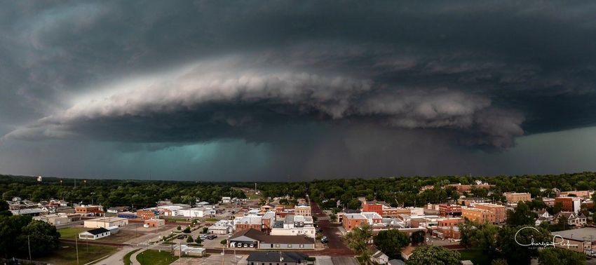
Kansas Tornadoes 2022

     56 tornadoes impacting 29 counties
             7 tornadoes crossed county lines

            Kansas Tornado Facts
Days with more than 20 tornadoes       Kansas Tornado Count by Decade
    Date        #Tornadoes                     1950s: 560
      05/23/08          70                     1960s: 457
      04/14/12          43                     1970s: 303
      06/15/92          39                     1980s: 339
      05/05/07          36                     1990s: 789
      05/24/16          34                     2000s: 1192
      06/04/55          33                     2010s: 768
      05/29/04          28                     2020s: 110
      10/26/06          28
      05/25/97          25
      06/09/05          25              Most Tornadoes in One Episode
      05/15/91          24             May 23, 2008        70 Tornadoes
      07/07/04          23             April 14, 2012      43 Tornadoes
     05/06/15            22            June 15-16, 1992    41 Tornadoes
      04/26/91          21
      06/15/09          21

             KANSAS SEVERE WEATHER AWARENESS WEEK
                        MARCH 6-10, 2023
                                   5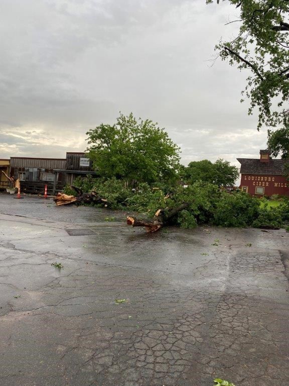
Did you know...
     There are seven National Weather Service offices that serve portions of Kansas!
National Weather Service (NWS) offices serving Kansas are located in Goodland; Dodge City;
Wichita; Topeka; Hastings, Nebraska; Pleasant Hill (Kansas City), Missouri; and Springfield, Mis-
souri. Each office is staffed by a team of highly trained meteorologists, technicians, electronics
technicians, information technology specialists, hydrologists, and administrative assistants. The
NWS offices are staffed 24 hours a day, seven days a week, 365 days a year.

Contact the NWS office in your area to learn more about weather, weather safety, NOAA Weath-
er Radio, office tours, or to learn more about careers in meteorology in the NWS or in NOAA.
                                    We are here to serve you!

     The following pages contain 2022 severe weather summaries for each
      NWS office. Here is severe weather terminology you may encounter.
• Severe Thunderstorm – The National Weather Service issues severe thunderstorm warnings
  for storms that are currently or are capable of producing winds of 58 mph or stronger and/or
  hail one inch in diameter or larger. Severe thunderstorms are often much stronger than this
  minimum criteria, so it is a good idea to take severe thunderstorm warnings seriously.
• Tornado – A tornado is a violently rotating column of air in contact with the ground either as a
  pendant from a cumuliform cloud or underneath a cumuliform cloud, and it is often (but not al-
  ways) visible as a funnel cloud. A funnel cloud is a condensation cloud typically funnel-shaped
  and extending outward from a cumuliform cloud and is associated with a rotating column of air
  that may or may not be in contact with the ground.
• Flash Flood – A flash flood is flooding that occurs very rapidly and usually within six hours of
  heavy rainfall. Flash flooding may occur along creeks, rivers or streams. It can also occur in low
  lying or urban areas where drainage is poor. Water levels can rise very quickly during flash flood-
  ing including locations that did not receive the heavy rainfall but are located downstream from areas
  that received an extreme amount of rainfall. Flash flooding can occur in the winter months when
  rain falls on existing snowpack and causes it to melt rapidly. Flooding is the number one severe
  weather killer in the U.S.
                        KANSAS SEVERE WEATHER AWARENESS WEEK
                                   MARCH 6-10, 2023
                                                  6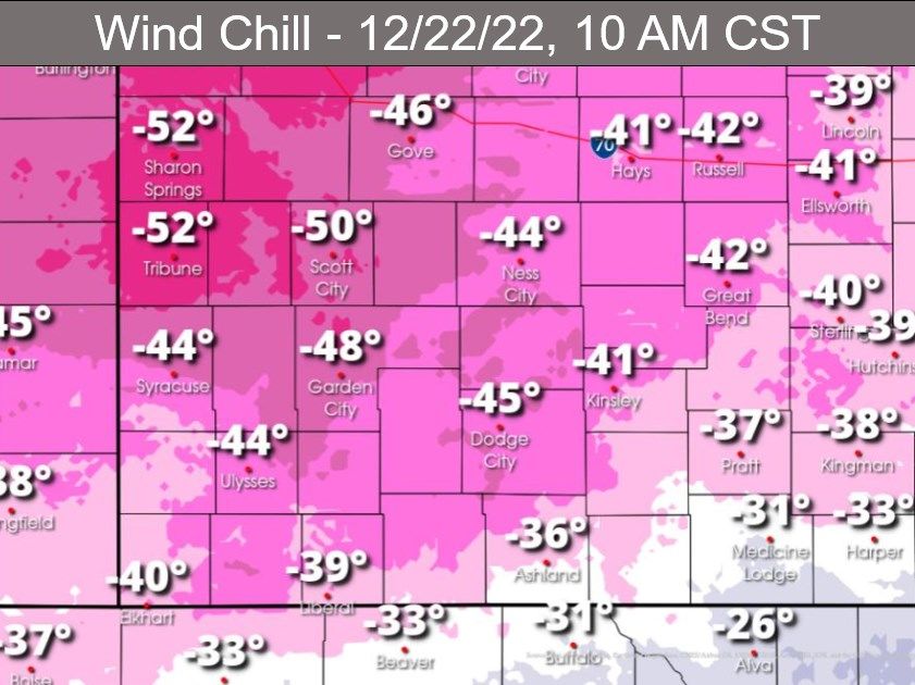
2022 Severe Weather Summary
                               Extreme East Central and Northeast Kansas
                               National Weather Service - Pleasant Hill, MO
                                 Severe weather was limited across eastern Kansas last year as
   2022 Far Northeast            drought conditions prevailed through much of severe weather sea-
 Kansas Severe Weather           son. However, a few widespread severe weather events did occur
         Stats                   in 2022. Most notable of these events was the June 8 th event where
    by the Numbers               a line of storms moved through east central Kansas with a few em-
                                 bedded tornadoes along the line. In addition to that event there
Number of Severe Wind, Hail,
Flooding Reports: 32             were a few events that produced damaging winds and large hail.
                                 Due to drought conditions, flooding was not much of an issue dur-
Tornado: 3                       ing the severe weather season of 2022.

Largest Hail: 1.5” (Atchison     June 8th 2022, EF-1 and EF-0 Tornadoes and Strong Winds
County, May 30th)                Strong to severe thunderstorms in eastern Kansas developed late
                                 on June 7th and continued to evolve into a complex of strong to se-
Strongest Wind: 70 mph (Linn     vere thunderstorms as they moved into east central Kansas be-
& Miami counties, July 8th)      tween 12:30 – 1AM on the 8th. These storms resulted in numerous
                                 wind damage reports as well as three confirmed tornadoes. The
Most reports received:           strongest of the 3 tornadoes was an EF-1 that developed on the
Johnson County (17)              west side of Lenexa (Johnson County) embedded within the larger
                                                line of thunderstorms moving across the west side of
                                                the Kansas City Metro. This tornado travelled east
                                                into Overland Park varying in strength before dissi-
                                                pating after it crossed into Missouri. The estimated
                                                peak wind was 100 MPH with a path length of 9.53
                                                miles and a width of 125 yards. The other two torna-
                                                does were EF-0 tornadoes that developed along the
                                                southern end of a larger line of storms in Miami
                                                County near the towns of Louisburg and Paola. The
                                                tornadoes had path lengths of 9.74 miles and 9.55
                                                mile respectively; they were both 75 yards wide and
 EF-1 tornado path                              had estimated peak winds of 85 MPH. The Louis-
                                                burg tornado damaged the historic Louisburg Cider
                                                Mill (image on next page).

Damage from EF-1 tornado to Colonial Presby- EF-0 tornado path near Paola
terian Church in southern Kansas City.
                          KANSAS SEVERE WEATHER AWARENESS WEEK
                                       MARCH 6-10, 2023
                                                  7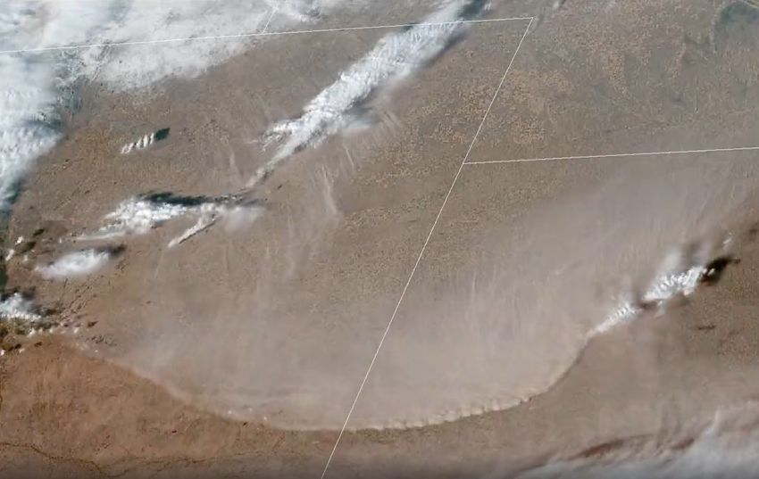
In addition to the June 8th event,
northeastern and east central
Kansas had 8 additional days in
which severe weather events
were reported. The first of these
widespread severe weather
events occurred on April 29th
where reports of one inch or
quarter sized hail and wind gusts
up to 65 mph were reported in      EF-0 tornado path near Louisburg
Linn, Wyandotte, Doniphan and
Leavenworth counties. On May 15th, a widespread severe wind event oc- Damage to Louisburg Cider
curred where there were several reports on 60 to 65 mph winds in Leav- Mill from EF-0 tornado.
enworth, Wyandotte and Johnson Counties. The last widespread severe weather event occurred on
June 21st again producing damaging winds in Doniphan, Leavenworth and Johnson counties where
60 to 65 mph winds occurred.

                                   2022 Severe Weather Summary
                                         Southeast Kansas
                              National Weather Service - Springfield, MO

  2022 Far Southeast           Like 2021, 2022 was a quiet year for extreme southeastern Kansas
Kansas Severe Weather          with regards to severe weather, partially due to the development of
                               drought that began in June. Severe storms were witnessed only in
        Stats                  April, May, June, August and October with only a handful of severe
   by the Numbers              weather events reported then. There were no tornadoes, and no oth-
                               er events were overly extreme with the highest wind gust occurring
Number of Severe Wind,         as a cold front moved through southeastern Kansas producing winds
Hail, Flooding Reports: 17     up to 64 mph on August 3rd.
Tornadoes: 0                   The largest hail reported only reached ping pong ball size which oc-
                               curred on April 21st near Marmaton. Otherwise there were a handful
Largest Hail: 1.5” (Bourbon    of other hail reports of quarter to half dollar size during the spring and
County, April 21)              fall. Flooding rainfall was even less frequent. Only a few reports of
                               flooding occurred in May. Most of the reported flooding was street
Strongest Wind: 64 mph         and urban flooding; however, Highway 160 in Crawford County was
(Bourbon County, August 3)     flooded after between 4 and 6 inches of rain fell.
Most reports received:
                            Relatedly, drought conditions developed in June and continued
Bourbon & Cherokee counties
(7)                         through the end of the year. The combination of heat and dry condi-
                            tions allowed a deterioration to D4, Exceptional Drought conditions.
                            Reports of near total crop and hay losses resulted. Rainfall in the fall
                            and early winter helped mitigate the severity of the drought condi-
                            tions.
                           Check out these additional resources
             Helpful Weather Websites Seasonal Safety Campaigns
                    Lightning Safety Toolkits StormReady Program
                         KANSAS SEVERE WEATHER AWARENESS WEEK
                                    MARCH 6-10, 2023
                                                   8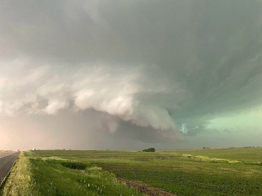
2022 Severe Weather Summary
                                  Northeast and East Central Kansas
                                 National Weather Service - Topeka, KS

2022 Northeast Kansas        The 2022 severe weather season across north central and northeast
                             Kansas featured 15 tornadoes. That was the highest number for the
 Severe Weather Stats        NWS Topeka service area since 2008. Thankfully there were no fa-
   by the Numbers            talities and no serious injuries from the tornadoes. The busiest day
                             for tornadoes was June 11th when a single supercell thunderstorm
Number of Severe Wind,
                             spawned seven tornadoes. The strongest of those seven was a brief
Hail, Flooding Reports: 268
                             EF2 tornado that produced significant damage to a few homes on
Tornadoes: 18                the east side of Manhattan. The longest track tornado was an EF1
                             that tracked nearly 15 miles across rural areas of Morris County on
Largest Hail: 4” (Dickinson  April 29th. The majority of documented tornadoes occurred on just
County, April 29)            two days in 2022. There were five documented tornadoes on April
Strongest Wind: 115 mph      29th and seven documented tornadoes from a single supercell thun-
(Riley County, June 11)      derstorm on June 11th. Two other EF1 tornadoes were documented
                             on June 7th while the first tornado of the year was documented on
Most reports received: Dick- March 29th which was also an EF1.
inson County (39)

                               April 29th tornadoes – On the same day that an EF3 tornado struck
                                                     Andover Kansas, other supercell thunder-
                                                     storms developed across parts of central and
                                                     northeast Kansas. These storms produced
                                                     five different documented tornadoes. Thank-
                                                     fully most of the tornadoes occurred in rural
                                                     areas and that helped to limit the overall ex-
                                                     tent of damage. All of the tornadoes were rat-
                                                     ed EF0 or EF1 with the longest track tornado
                                                     estimated at around 15 miles across eastern
                                                     Dickinson and Morris counties.

                                                        The photo on the left was taken by Jim
          Tornado development NW of Herington.          Ladue. It shows the development of the long-
          Courtesy of Jim Ladue.                        er track tornado that began northwest of He-
                                                        rington and then proceeded to move ENE for
                                                        approximately 15 miles through rural areas of
                                                        Morris County. This tornado was rated an
                                                        EF1.

                                                        The radar image to the left captured the early
                                                        stages of this tornado as it moved north of the
                                                        city of Herington and eventually ENE into
                                                        Morris County. The left image is called reflec-
                                                        tivity and depicts precipitation intensity while
                                                        the image on the right is called storm relative
          Radar imagery of tornado. Reflectivity is     velocity and depicts the direction and strength
          on the right. Storm relative velocity is on   of wind speeds within the thunderstorm.
          the left.

                         KANSAS SEVERE WEATHER AWARENESS WEEK
                                    MARCH 6-10, 2023
                                                   9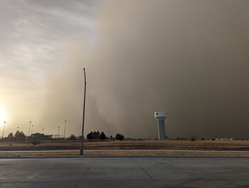
June 11th long lived super-
                                                                    cell and associated seven
                                                                    tornadoes – A single long-
                                                                    lived supercell thunderstorm
                                                                    produced seven different docu-
                                                                    mented tornadoes during the
                                                                    afternoon and evening of June
                                                                    11th. The supercell tracked al-
                                                                    most due south as it moved
                                                                    out of Nebraska through Mar-
                                                                    shall County where four differ-
Courtesy of Charles Peek                                            ent tornadoes were document-
                                                       ed. The supercell proceeded to move
south into western Pottawatomie and eastern Riley counties. This storm produced three more tor-
nadoes including a brief but strong EF2 tornado on the east side of Manhattan. This storm eventu-
ally moved south into Lyon and Chase counties producing damaging winds and large hail.

The photo at right was taken by Jared Leighton look-
ing west along Highway 36 toward Marysville. It
shows a distinct funnel cloud extending toward the
ground. This funnel did become a brief tornado and
did sporadic damage just northeast of Marysville in
Marshall County. Another small tornado was located
further west at this time but is obscured by rain from
this perspective. That small tornado also did damage
to structures on the west side of Marysville. This fun-
nel and eventual tornado was one of seven document-
ed tornadoes that occurred with this supercell thun-
derstorm.

The radar image at right shows the high precipitation
(HP) supercell with reflectivity at left and storm rela- Funnel cloud looking west along U.S. High-
tive velocity at right. A large area of damaging winds way 36 towards Marysville.
can be inferred (blue colors) in what is called the rear Courtesy of Jared Leighton.
flank downdraft region of the storm. The wide-
spread extent of the rainfall around the circula-
tion made any visual confirmation of a tornado
very difficult.

2022 was also a year of extremes for northeast
Kansas especially when looking at the precipita-
tion patterns. May saw the most intense rain of
the year with over one-third of the year’s total. In
fact, it was the 3rd wettest May on record at To-
peka and then dry conditions followed through
the rest of the year. While skewed a little by the
very wet May (6.5" above normal for the month), Radar imagery with reflectivity on left and storm
from January through May, Topeka was 4.22" relative reflectivity on right.
above normal for precipitation. From June
through the end of the year, Topeka was

                        KANSAS SEVERE WEATHER AWARENESS WEEK
                                   MARCH 6-10, 2023
                                                10
8.52" inches below normal. This is seen in the
graphics below that show precipitation departures
for Topeka. It was wet in the first half of the year
then very dry for the second half of the year.
Finally, northeast Kansas experienced brief but
very cold temperatures at the end of the year in
December. An Arctic cold front passing on De-
cember 21 brought temperatures of 0 to -5 from
sunrise of December 22 through midday of De-
cember 23 with wind chill values from -20 to -40.
The wind chills were the lowest many areas had
experienced in around 30 years. The cold did not
last long; however, by midday on December 29 temperatures returned to the 60s making it feel al-
most 95 degrees warmer than a week earlier! Notable that Topeka broke or tied 17 warm tempera-
ture records and only one cold temperature record in 2022.
2022 Severe Weather Summary
North Central Kansas
National Weather Service - Hastings, NE
2022 North Central
After what turned out to be a fairly wet winter season, the spring and
Kansas summer severe weather season brought its usual barrage of hail and
Severe Weather Stats wind but was lacking one thing: tornadoes. This marked the third
by the Numbers straight season with no confirmed tornadoes in north central Kansas.
The last confirmed tornado was on May 28, 2019 in Mitchell and Os-
Number of Severe Wind, borne counties.
Hail, Flooding Reports: 45
Tornadoes: 0 Ironically as drought conditions
worsened in 2022, there were
Largest Hail: 2.75” (Phillips two flood events which were the
County, May 14) most notable events of the sea-
son. The first was in an isolated
Strongest Wind: 75 mph part of Phillips County centered
(Osborne County, May 17) about 5-10 miles north of Phillips-
Most reports received: Phil- burg. On April 28th, the “one-
lips County (16) storm-show” dumped an isolated
but very large area of 4-6 inches
of rain. Unofficially, up to nine
inches of rain was reported to
have fallen in this area. Flood
damage within the heaviest rain
area was widespread. A weather
observer about six miles east of
Phillipsburg along the Big Creek
reported flooding despite receiv-
ing only about 0.10 of an inch of U.S. Highway 183 in Stockton on
rainfall at his location. Hail to the June 5, 2022.
Courtesy of the Stockton Sentinel
KANSAS SEVERE WEATHER AWARENESS WEEK
MARCH 6-10, 2023
11size of golf balls accompanied the heavy rain across
much of northern Phillips County.
A little over a month later, on June 5th to be exact, heavy
rain and hail pummeled the Stockton area in Rooks
County. Although the rain amounts weren’t quite as high,
roughly around four inches, some streets became im-
passable in the Stockton area including U.S. Highway
183. Water flowed over numerous roads in town; county
roads were damaged, and several basements flooded in
the area.
Aside from the two flooding events, a mixture of wind and
hail impacted north central Kansas in 2022 in the late
spring and early summer. There were several reports of
hail and wind gusts to 60 mph during the last week or so
of April. In mid-May, thunderstorms rumbled through
Phillips and Osborne counties bringing hail to the size of
ping-pong balls and winds estimated as high as 75 mph.
In the first part of June, activity picked up again, but this
time included Smith County where 70+ mph winds
caused roof damage to a local business and livestock
shed at Smith Center on June 12th. A few more thunder-
Flooding southwest of Phillipsburg (West storms brought hail and 60 mph winds on the 22nd and
Limestone Road) on April 28, 2022. 30th.
Courtesy of Phillips County Emergency
Management The last half of the summer and fall were quiet in terms
of severe weather across north central Kansas as the
early season moisture gave way to the heat of summer and dryness often associated with fall. By
the end of September, severe drought had returned to parts of Rooks, Osborne and Phillips coun-
Check out a storm identification and weather safety training
presentation near you this spring!
Each spring, the National Weather Service offices that serve the state of Kansas conduct storm
identification and weather safety training sessions in most counties in the state. The sessions are
free and open to the public. You are not required to become a storm spotter nor will you have to
take a test; however, the presentations provide a great deal of information on severe weather in
Kansas. They cover severe weather safety and ways to get weather information from the Nation-
al Weather Service. You can also meet a meteorologist from your local National Weather Service
office.
The schedule for storm identification training sessions varies in each community, please check
out www.weather.gov and click your location for more information on a training session in your
area. Otherwise use this link: https://bit.ly/40ksxUg
KANSAS SEVERE WEATHER AWARENESS WEEK
MARCH 6-10, 2023
122022 Severe Weather Summary
Central, South Central & Southeast Kansas
National Weather Service - Wichita, KS
2022 Central, April 29th Severe Weather
South Central and
Scattered to numerous strong to severe thunderstorms developed
Southeast Kansas during the evening of April 29th across portions of central, south-
Severe Weather Stats central and southeast Kansas, along and ahead of a strong dryline
by the Numbers and cold front approaching from the west. Notable severe weather
reports across Wichita’s forecast area included nine tornadoes, hail
Number of Severe Wind, up to the size of tennis balls, and damaging straight-line winds
Hail, Flooding Reports: 282 reaching 111 mph. This was a highly anticipated severe weather
day due to high amounts of instability and strong vertical wind
Tornadoes: 19 (Average 19)
shear. Storms were initially slow to develop along the preceding
Largest Hail: 3.25” (Marion dryline due to a modest capping inversion in place. However, nu-
County, May 31) merous convective attempts over a two to three-hour period eventu-
ally eroded the cap sufficiently for strong to severe thunderstorms to
Strongest Wind: 111 mph ensue.
(Greenwood County: April 29
estimated) Probably one of the most no-
table thunderstorms of the
Most reports received: Sedg- night was a supercell that
wick County (67) tracked northeast from south-
east Sedgwick County then
across Butler and Greenwood
counties. This supercell pro-
duced three tornadoes; the
most notable was an EF3 that
tracked northeast 12.7 miles
across southeast Sedgwick
Tornado tracking through Andover.
County through west and Courtesy of Josh Wells
northwest Butler County.
Hardest hit was Andover
where winds up to 155 mph produced a swath of damage up to 440
yards wide. Severe damage occurred to both residential and com-
mercial areas with estimated property damage of $41,500,000. The
YMCA took a direct hit causing extensive damage to the facili-
ty. Prompt safety actions
taken by the YMCA staff
prior to the tornado’s im-
pact likely prevented nu-
merous injuries at the
facility and possibly even
saved lives. The tornado
also caused damage to
Prairie Creek Elementary
school, but fortunately it
hit well after the school
Damage to the YMCA in Andover. Damage to a home in an Andover day ended. Furthermore,
neighborhood.
KANSAS SEVERE WEATHER AWARENESS WEEK
MARCH 6-10, 2023
13a Dillon’s grocery store and a large apartment complex were near-misses just to the west. Three
people were injured in this tornado.
The supercell continued tracking east-northeast producing another tornado near Rosalia in eastern
Butler County. This tornado traveled 8.1 miles, reached a path width of 100 yards, and had estimat-
ed peak winds of 100 mph, giving it an EF1 rating. Agricultural buildings and trees incurred damage
west-southwest of Rosalia. Fortunately, no one was injured.
Meanwhile, further west-northwest, thunderstorms rapidly developed southwestward along an east-
ward advancing cold front. While these storms were not initially supercells, the strong updrafts com-
bined with the strong cold front to produce several relatively short-lived “landspout” tornadoes
across Marion County, more specifically near Tampa, Durham, Lehigh, and Hillsboro. Estimated
winds from these tornadoes were 70 to 96 mph (EF0 and EF1 ratings) with track lengths up to 0.9
miles. Relatively minor damage was inflicted to some outbuildings and trees.
The largest reported hail that evening was tennis ball sized hail near El Dorado Lake, and the
strongest estimated non-tornado thunderstorm wind gust was 111 mph west of Eureka which
snapped tree trunks as well as four electric transmission poles and downed tree limbs.
Very Dry Second Half of 2022
After near to above average precipitation dominated much of central, south-central and southeast
Kansas from January through June, Mother Nature turned off the spigot the second half of 2022 es-
pecially July through October. The lack of precipitation was most pronounced across portions of
central and southern Kansas where some locations tallied July through December deficits over 10
inches below average and recorded one of their driest July through December periods on record.
The ongoing lack of precipitation and resultant warmer than average temperatures supported wors-
ening drought conditions across much of central, south-central and southeast Kansas.
Depiction of drought through 2022. Courtesy of the U.S. Drought Monitor
KANSAS SEVERE WEATHER AWARENESS WEEK
MARCH 6-10, 2023
142022 Severe Weather Summary
Southwest Kansas
National Weather Service - Dodge City, KS
2022 Southwest Kansas Drought
The main weather phenome-
Severe Weather Stats non and most concerning to
by the Numbers local agriculture was the
drought that enveloped west-
Number of Severe Wind, ern Kansas. None of the coun-
Hail, Flooding Reports: 195 ty warning area (CWA) fell un-
Tornadoes: 4 der Exceptional Drought (D4)
conditions when the year be-
Largest Hail: 4” (Hodgeman & gan; however, by year’s end
Pawnee counties, June 6) over 90 percent was solidly
Strongest Wind: 100 mph classified as D4. In fact, a ma-
(Morton County, June 19) jority of the CWA only received
50 percent or less of its yearly
Most reports received: Ford normal precipitation.
County (28)
Winds, Wildfires, and Dust
Continuing with the trend that began in late 2021, southwest Kansas
experienced numerous High Wind Warning events through the year.
One notable event occurred on April 6th and 7th where strong north-
west winds created blowing dust across much of western Kansas.
Visibilities dipped to near zero in some places and very dry condi-
tions contributed to several wildfires during the afternoon hours. An-
other major wind event occurred on December 2nd when a strong
cold front moved through the region. As the leading edge of the air
mass scoured drought-stricken terrain, a huge wall of dust raced
down from the northwest. Blowing dust with reduced visibility com-
menced in the early afternoon and continued well into the night
hours. Throughout the year, there were a total of 38 days when the
Dodge City Regional Airport gusted above 50 mph, reaching a new
record.
GOES Satellite Dodge City on December 2nd at
4:40PM.
KANSAS SEVERE WEATHER AWARENESS WEEK
MARCH 6-10, 2023
15Severe Thunderstorms
Severe convective outbreaks were below normal in 2022, but of the few storms that occurred, some
were very intense. The largest hailstone reported in Dodge City’s CWA in 2022 was 4 inches on
June 6th near Hanston, Kansas. The strongest wind gust measured during the year was 92 mph on
June 8th near Elkhart, Kansas. Only four tornadoes were reported, and these all occurred in Ford
and Comanche counties.
Arctic Air
A large swing in temperature was observed across
southwest Kansas February 22nd into the 23rd. Highs
on the 22nd reached near 70 degrees before a cold
front moved through the area that evening. Lows the
morning after dipped to around zero degrees with wind
chills in the negative 20s.
The end of the year was also very cold as a result of a
strong cold front moving down through the snow cov-
ered Northern Plains and into southwest Kansas on
the night of December 21st. Lows in the negative sin-
gle digits were observed on the morning of the 22nd
with highs only reaching into the single digits to
around zero degrees that afternoon. The cold air ad-
vection continued that night with lows dipping into the
negative single digits to low teens. Strong northerly winds gusting in the 50 mph range was ob-
served behind this system allowing for wind chills to dip into the -30 to -50 degree range both morn-
ings.
Heavy Snow
During a year of abnormally low precipita-
tion, the most significant snow storm oc-
curred on January 25th where over a foot of
snow fell across portions of west central
Kansas. Snowfall totals reached 22 inches
in Scott County when a strong mesoscale
band formed. This snowpack persisted for
several days after this system moved out of
the area creating a pocket of much cooler
temperatures over west central Kansas.
Be sure to find your local NWS office on Social Media
NWSDodgeCity NWSSpringfield
NWSGoodland NWSTopeka
NWSHastings NWSWichita
Also be sure to check if your county NWSKansasCity
emergency manager has a facebook
page for your county.
KANSAS SEVERE WEATHER AWARENESS WEEK
MARCH 6-10, 2023
162022 Severe Weather Summary
Northwest Kansas
National Weather Service - Goodland, KS
2022 Northwest Kansas Northwest Kansas experienced several severe weather events dur-
Severe Weather Stats ing 2022, although the season as a whole can be classified as hav-
ing below-normal severe thunderstorm activity. All modes of severe
by the Numbers weather were reported including tornadoes, damaging thunderstorm
winds, large hail, flooding, and dust storms. One oddity of the 2022
Number of Severe Wind,
severe weather season was the lack of flooding reported. Only three
Hail, Flooding Reports: 180
reports of a flood were received, much lower than normal. However,
Tornadoes: 15 this can be easily explained by the lack of thunderstorm activity in
general along with the long-duration drought conditions that the re-
Largest Hail: 2.75” (Wichita gion is still currently experiencing. Despite the below normal occur-
Co. April 22, Decatur Co. rence of severe events, a total of 15 tornadoes were reported across
June 7, Norton Co. June 9) northwest Kansas.
Strongest Wind: 100 mph
April 22nd, 2022 Severe Thunderstorms and Tornadoes
(Thomas Co. April 22, Decatur
Co. April 23) A significant weather event struck
Most reports received: De- the High Plains on April 22nd. This
catur County (28) event brought daytime wind gusts
over 70 mph as well as dust storm
conditions and the threat for sig-
nificant wildfires. Later in the afternoon, a first round of severe
thunderstorms developed producing numerous reports of large
hail, up to the size of baseballs, and damaging wind gusts as
they moved across northwest Kansas.
A more significant round of storms developed late that evening
across eastern Colorado moving across northwest Kansas dur- Damage to a KDOT facility in
ing the overnight hours. A total of five tornadoes occurred, in- Sharon Springs.
cluding one in particular that struck Sharon Springs. This partic-
ular tornado was rated an EF-1 with maximum wind speeds of 110 mph due to significant damage
to several buildings in town, downing numerous trees and power lines, breaking windows, rolling a
variety of trailers, and other associated damage. These tornadoes were of the quasi-linear convec-
tive system (QLCS) variety, or in other words tornadoes that form within a squall line/line of storms,
not the isolated supercells that Kansas is so familiar with. In terms of reports and damage, this was
the most significant event to strike northwest Kansas in 2022.
July 22nd Thunderstorms
During the afternoon of July 22nd, a broken line of storms formed
across northwest Kansas and into southwest Nebraska. Initially
these storms produced six landspout tornadoes across mainly
southwestern Thomas County. Eventually the group of storms start-
ed to progress slowly to the southeast at which point damaging
winds and large hail became the predominant weather threats. Golf
ball sized hail and wind gusts as high as 90 mph occurred. The au-
tomated weather sensor in Hill City reported a wind gust of 82 mph.
Zoomed in picture of a super-
cell moving across NW KS. The municipal airport in Hoxie took a substantial hit from the straight
Courtesy of Kody Wilson -line winds resulting in damage to an airplane hangar.
KANSAS SEVERE WEATHER AWARENESS WEEK
MARCH 6-10, 2023
17Enroll Here to Become an Ambassador
www.weather.gov/wrn/amb-tou
KANSAS SEVERE WEATHER AWARENESS WEEK
MARCH 6-10, 2023
18You can also read