A Path to Creating the First Generation of High Seas Protected Areas - Science-based method highlights 10 sites that would help safeguard ...
←
→
Page content transcription
If your browser does not render page correctly, please read the page content below
Report                                                                 March 2020

A Path to Creating
the First Generation
of High Seas
Protected Areas
Science-based method highlights 10 sites that would help safeguard biodiversity
beyond national waters
Contents
3    Overview
4    Importance of the high seas
5    MPAs can help protect high seas biodiversity
7    Identifying a first generation of high seas MPAs
10   Results: Important areas to protect in the high seas
     Salas y Gómez and Nazca Ridges 12
     Costa Rica Dome 14
     Lord Howe Rise and South Tasman Sea 16
     Emperor Seamount Chain 18
     Mascarene Plateau 20
     Arabian Sea 22
     Gulf of Guinea 24
     Walvis Ridge 26
     Sargasso Sea and Corner Rise Seamounts 28

30   A new treaty can spur creation of high seas MPAs
31   Conclusion
32   Appendix: Methodological details
35   Endnotes

Table of maps and figures
5    Map 1: Global Shipping Routes Cross Critical Ocean Areas
     Beyond National Jurisdiction
8    Figure 1: Multiple Factors Determine Possible High Seas
     Protected Areas
9    Map 2: Visualization of Conservation Features Across the Oceans
10   Map 3: High Seas Areas That Meet 30% Conservation Objective
11   Map 4: Special Places in the High Seas Span the World’s Oceans
     and Regions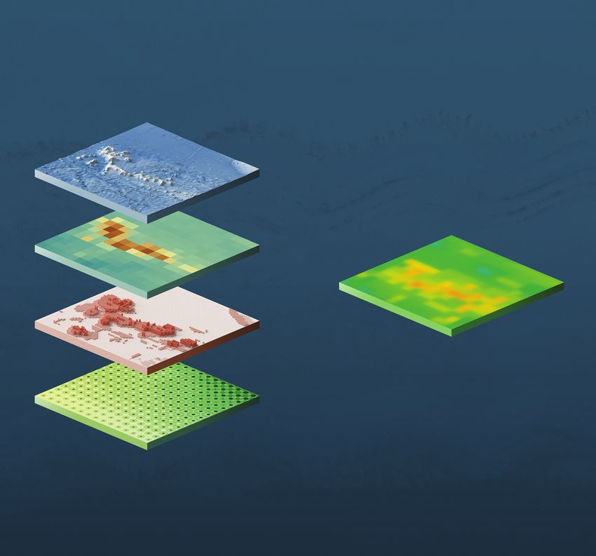
The Pew Charitable Trusts
Susan K. Urahn, executive vice president and chief program officer
Thomas Dillon, vice president and head of environment
Elizabeth Wilson, senior director, environmental policy
Project team
Liz Karan, project director
Nichola Clark, principal associate
About this report
This report is based on a data-driven analysis led by scientists at the University of California, Santa Barbara (UCSB)
that highlights priority areas for protection in the high seas. The report was researched and written by Nichola Clark,
a principal associate with The Pew Charitable Trusts’ initiative on protecting ocean life on the high seas, and Grace
Reville, a senior associate with the Blue Nature Alliance.
Acknowledgements
The data-driven analysis that served as the basis of this report was informed by two workshops that were co-led
by UCSB and The Pew Charitable Trusts. We are grateful to the following workshop participants for sharing their
expertise and input: Ben Best, Darcy Bradley, Reniel Cabral, Daniel Dunn, Elizabeth Forbes, Caroline Jablonicky,
Francis Joyce, Vicky Lam, Sara Maxwell, Juan Mayorga, Doug McCauley, Holly Moeller, Lance Morgan, Guillermo
Ortuño Crespo, Jim Palardy, Malin Pinsky, Morgan Visalli, and Tim White. This report does not necessarily reflect
the opinions of any of these individuals or their institutions. We also thank our two independent peer reviewers:
Beth Pike, conservation scientist at Marine Conservation Institute, and an additional reviewer who asked to remain
anonymous. This report does not necessarily reflect the opinions of these individuals or their institutions.
This report also benefited from the insights and guidance of the following external experts: Doug McCauley, Morgan
Visalli, and Ben Best, all at the University of California, Santa Barbara; Susanna Fuller at Oceans North; Duncan
Currie at Globelaw; and Mamadou Diallo, a marine biologist. Although they all provided input in the drafting stages,
neither they nor their organizations necessarily endorse the report’s conclusions. The project team also would like
to thank the following current and former Pew colleagues for their contributions: Ned Drummond for designing the
maps, figures, and illustrations; Casey Ehrlich, Justine Calcagno, Margaret Murphy, Mike Wissner, and Jim Palardy
for providing research guidance; Liz Karan, Michelle Grady, Aaron Kornbluth, Grant Galland, and Angelo Villagomez
for their input in developing the report; and Michael Remez, Bernard Ohanian, Tricia Olszewski, Jennifer Peltak,
Robert Lalle, and Marti Ostrander for their editorial and communications support.
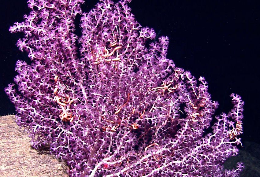
Cover photo: Universal History Archive/Universal Images Group/Getty Images
A white branched octocoral with purple polyps and brittle stars.
Contact: Marti Ostrander, manager, communications Email: mostrander@pewtrusts.org
Project website: pewtrusts.org/en/projects/protecting-ocean-life-on-the-high-seas
The Pew Charitable Trusts is driven by the power of knowledge to solve today’s most challenging problems. Pew applies a
rigorous, analytical approach to improve public policy, inform the public, and invigorate civic life.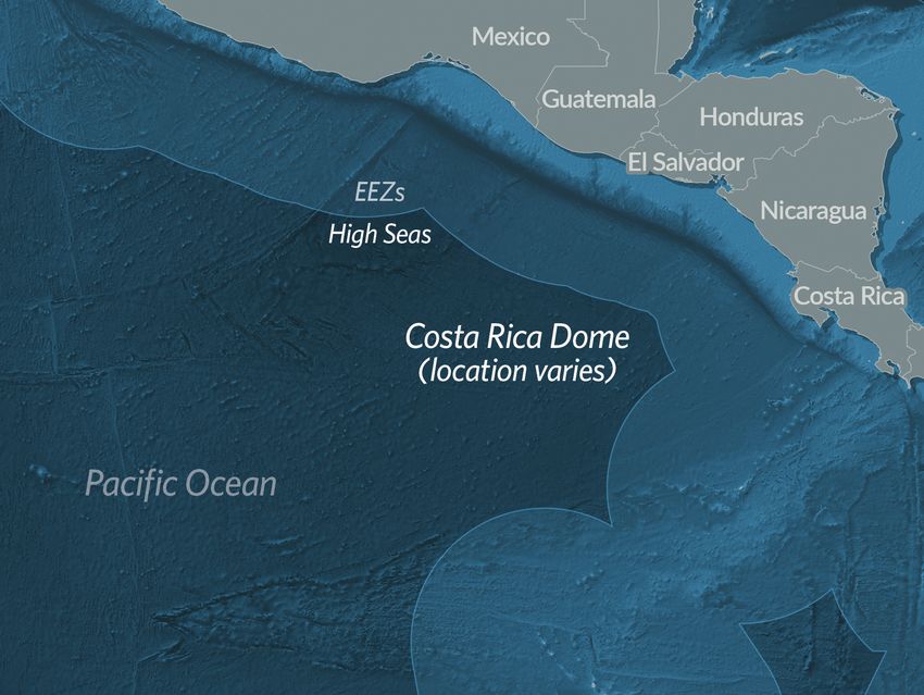
Overview
Beyond the horizon, more than 200 nautical miles from shore, lies an area of the ocean known as the high seas.
These waters, beyond the jurisdiction of any nation, make up roughly two-thirds of the ocean and cover nearly
half of the planet’s surface. Much is still to be learned about these areas, but scientists know they teem with life
and are among the largest reservoirs of ocean biodiversity. The high seas support abundant fisheries; provide
habitat and migratory routes for whales, sharks, sea turtles, and seabirds; and harbor remarkable ecosystems,
such as deep-water corals and other majestic marine life.

The high seas are also an increasingly busy space; rapid advances in technology and increasing demand for
goods and trade in recent decades mean virtually no part of the ocean—including these waters far from shore—
remains untouched by human industrial activity. Currently, a patchwork of different regional and sectoral
organizations manages this last global common space with little coordination among organizations, and that
is leading to the degradation of the marine environment and its resources. These areas belong to everyone, yet
governments currently have no comprehensive legal mechanism in place to protect high seas marine life.

There is an opportunity for this to change. Negotiations are under way at the United Nations to finalize a new
high seas treaty focused on the conservation and sustainable use of marine biological diversity beyond national
jurisdiction. The treaty could allow nations to establish comprehensive, cross-sector marine protected areas
(MPAs) on the high seas. These areas, when well-managed, can be effective tools in building ocean resilience
to climate change, avoiding fisheries collapse, and preserving biodiversity. Currently, less than 1 per cent of
high seas waters are highly protected, but scientific evidence suggests that protecting at least 30 per cent of
the ocean is more likely to achieve long-term ocean health objectives.1 High seas MPAs can play a key role in
reaching this target.

Although there is much still to discover, scientists have sufficient data and research to begin mapping and
modeling hot spots of biodiversity on the high seas.2 This report identifies some of the special places that could
benefit from protections established under a new high seas treaty. The findings build off a project funded by The
Pew Charitable Trusts and led by scientists at the University of California, Santa Barbara (UCSB) in conjunction
with partners from 13 universities and organizations. Using an algorithm that allows for consideration of
multiple factors, researchers developed a data-driven analysis to identify areas in the high seas of outstanding
conservation value.

The 10 sites highlighted represent areas with a spectrum and combination of important features, such as
species richness, productivity, and habitat diversity. They are located in oceans that span the globe.

This report also includes recommendations to inform the negotiations under way to finalize a new legally
binding international agreement. The agreement should ensure the establishment of effective high seas
protections, including by setting meaningful conservation objectives and requiring enforceable management
plans for these critical waters beyond the jurisdiction of any single nation.

                                                                                                                 3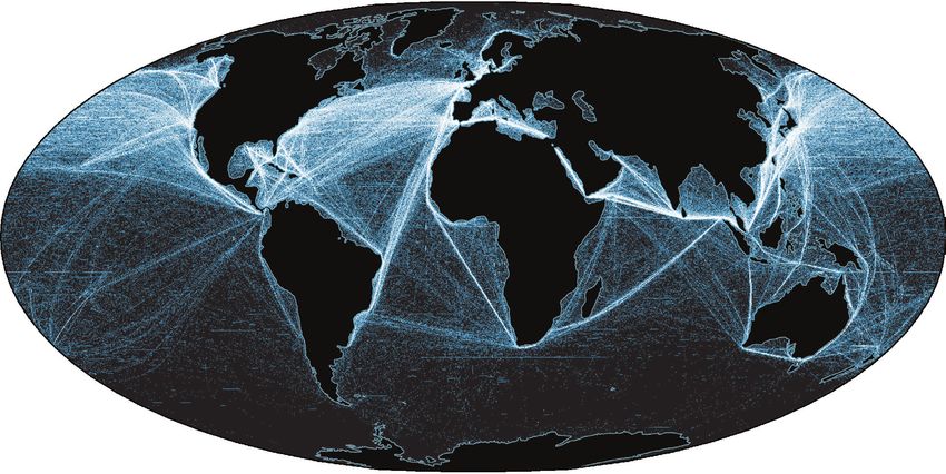
Importance of the high seas
The high seas are vital to life on Earth. With an average depth of more than 4 kilometres (2.5 miles) and a
maximum depth of over 10 kilometres (6.2 miles), these waters sustain an array of marine fauna and flora
and serve as a throughway for migratory species such as whales, sharks, seabirds, tuna, and sea turtles.
Although these areas are remote and have proved difficult to explore, scientists estimate that they represent
about 95 per cent of the occupied habitat of Earth and believe there could be millions of undiscovered
species beyond national jurisdiction.3

These waters also hold an astonishing variety of tiny microscopic organisms called phytoplankton that
produce almost half of the world’s oxygen supply.4 Through photosynthesis, these organisms convert carbon
dioxide from other marine life and the atmosphere into the air we breathe. Further, the high seas help to
regulate global air temperatures and slow the impact of climate change on land by absorbing and storing
excess carbon dioxide from the atmosphere. In 2014, the Global Ocean Commission estimated the economic
value of removing this carbon from the atmosphere at US$74 billion to US$222 billion per year.5 At the
same time, however, higher levels of carbon dioxide in the atmosphere have contributed to rising ocean
temperatures and increased acidity. These changes threaten ecosystems and habitats that marine species
depend on and add to problems such as coral bleaching and reduced oxygen concentrations, the process
known as deoxygenation.

By contrast, the gross value of the catch in high seas fisheries is estimated at US$7 billion to US$16 billion a
year.6 Industrial fishing fleets work in more than half of these ocean areas,7 and over one-third of these fish
stocks are overexploited.8 The 2018 State of World Fisheries and Aquaculture report by the United Nations
Food and Agriculture Organization (FAO) highlighted the declining status of high seas fish stocks and
recognized the need for more effective management measures.9 According to the report, the percentage of
stocks fished at biologically unsustainable levels increased from 10 per cent in 1974 to 33.1 per cent in 2015.10

Academic studies suggest that the percentage of overexploited fish stocks may be significantly higher.11 Over
the past 50 years, stocks of tuna and other highly migratory tuna-like species such as marlin and mackerel
have declined on average by 60 per cent; many are now considered fully or overexploited.12

Deep-sea fishing is also a concern. Species there live in extreme conditions with limited access to light and
food. Many, such as deep-sea sharks, are slow to reach sexual maturity and produce young only sporadically,
making them especially vulnerable to overfishing.13

Overfishing, however, is not the only threat. Roughly 90 per cent of world trade moves through shipping
across the high seas (see Map 1).14 Increased vessel traffic means few wild places completely free of human
industrial activity remain. Instead, marine mammals and other species increasingly face threats from ship
strikes, noise nuisance, and pollution from ballast water discharges and fuel leaks, all of which contaminate
high seas ecosystems.

  4
Map 1
Global Shipping Routes Cross Critical Ocean Areas Beyond
National Jurisdiction
Interconnected economies mean the high seas are increasingly busy spaces

Note: The lines represent shipping paths across the globe. The most heavily trafficked paths show up most brightly on
the map.
Source: B. Halpern et al., Cumulative Human Impacts: Raw Stressor Data (2008 and 2013), Knowledge Network for
Biocomplexity, https://doi.org/10.5063/F1S180FS
© 2020 The Pew Charitable Trusts

The health of the ocean is in decline, largely because of increased industrial activity. Even far from shore, the high
seas are not immune to the impacts of climate change, plastic pollution, overfishing, shipping, and other threats.
The cumulative effects of habitat destruction; pollution; noise from oil, gas, and mineral exploration; shipping;
and other human activities now affect 66 per cent of the ocean.15 And as technology develops, emerging activities
such as deep-sea mining and geo-engineering pose new risks to high seas marine life and ecosystems.16

MPAs can help protect high seas biodiversity
Although there are more than 20 high seas governance organizations, these bodies vary greatly in their
mandates—such as fisheries management, shipping regulation, and seabed mining management—but none has
a comprehensive cross-sectoral mandate with regulatory authority and a focus on conservation in areas beyond
national jurisdiction. As a consequence, despite widely accepted data showing the economic and environmental
value of the high seas, there is little in place to ensure conservation of biodiversity there. Currently only around 1
per cent of these waters are safeguarded in effectively managed and highly protected MPAs.17

                                                                                                                        5
Management of these protected areas for conservation can take a number of forms, from no-take reserves
where all extractive activities are banned to multiple-use zones, in which certain activities with low ecological
impact may be allowed. Scientists have found that MPAs—especially no-take reserves—are effective
conservation tools.

Research on similar efforts in domestic waters shows that MPAs yield the greatest conservation benefits when
they are large, highly protected, isolated, well-enforced, and long-standing. Benefits increase exponentially
when all five features are in place.18 A 2018 analysis found that the average biomass of fish within these marine
reserves is 670 per cent greater than in adjacent unprotected areas and 343 per cent greater than in partially
protected MPAs.19 Well-designed marine reserves can lead to larger fish populations beyond the boundaries
of the protected area, either from “spillover”—the migration of adult fish from the MPA—or the dispersal of
larvae spawned within it.20

Effective implementation and management are critical for protecting ocean life.21 MPAs that protect both the
water column and the seafloor conserve the marine environment most effectively.22 That’s because species
that live in the water column are interlinked with species that live on the seafloor, and both play essential roles
in their ecosystems.

Mesopelagic fish, which live in the middle depths, embody this vertical link through the water column. Each
day, they travel from the deepest parts of the ocean still penetrated by light to the surface. As they do, they
may become food for tuna and other commercially important species. They also bring organic carbon to the
deep, thus playing an important, though not yet fully quantified role in mitigating climate change.23 Most
seafloor organisms depend on food from the water column sinking to the bottom. Conversely, seamounts
at the ocean’s bottom can create upwellings that drive deeper, nutrient-rich water upward, which enhances
productivity at the surface.

Highly protected MPAs can also help marine ecosystems, including those on the high seas, better adapt and
become more resilient to the impacts of climate change.24 For example, by protecting large adult fish with high
egg production, marine reserves can help these populations recover after climate-induced oxygen depletion
mass mortalities.25

In the high seas, networks of MPAs that create meaningful links across habitats will benefit highly migratory
species such as whales and turtles. A well-connected MPA network can protect important places along their
routes, such as feeding or breeding grounds.26 The more time highly migratory species spend in protected
areas, the greater the benefits. Therefore, well-designed, well-connected MPA networks are critically
important for protecting these species.27

These MPA networks beyond national jurisdiction also could benefit coastal areas—and species that depend
on access to shore. Leatherback turtles, for example, spend most of the year on the high seas but travel to
coastal areas to lay their eggs. Despite efforts to conserve this endangered species, Pacific leatherback turtle
populations fell by more than 95 per cent over 20 to 30 years, a decline scientists attribute largely to deaths
as by-catch in the pelagic longline fishery.28 Although protecting nesting areas on coastal beaches is vital
to leatherback turtles’ recovery, it is equally critical that these creatures be protected from harmful fishing
practices in their high seas habitat.29

The health of the high seas affects that of national waters, especially fisheries. Overfishing key species on the
high seas can have devastating consequences for coastal nations, particularly those recognized by the United
Nations as least developed, where livelihoods depend upon healthy coastal resources.30

  6
Identifying a first generation of high seas MPAs
The high seas treaty presents an opportunity to protect hot spots of biodiversity and important or unique
ecosystems and ecosystem processes. The Pew Charitable Trusts engaged a team of scientists, led by Doug
McCauley at the University of California at Santa Barbara (UCSB), to identify areas of exceptional biological and/
or ecological value.31

    Key factors and methodology
    The researchers used a systematic conservation prioritization software called prioritizr R that identifies
    potential areas that meet conservation objectives while minimizing the opportunity cost, defined as
    forgone commercial fishing activities in a protected area.32 The algorithm then tries to find a solution that
    includes areas that meet conservation objectives while avoiding those with a high “cost” associated with
    them. (For more detail on methodology, see the appendix.)

    This analysis did not consider the 200-nautical-mile extent of ocean under national jurisdiction known as
    the exclusive economic zone (EEZ), consistent with other studies focused on high seas areas.33

    The analysis included a total of 54 different data layers of conservation features, grouped into six broad
    categories, and one cost layer:

    Conservation features
    Species richness. A measure of the organisms known or hypothesized to exist in specific waters, both
    now and in hypothesized future conditions, which take into account the anticipated impacts of climate
    change.

    Species extinction risk. An assessment of the vulnerability of these species to extinction, both looking at
    current conditions and what is likely under a worsening climate-change scenario.

    Seamounts. The distribution of large underwater mountains.

    Hydrothermal vents. The distribution of high seas hydrothermal vents, unusual seafloor formations in
    which superheated fluids from deep in the Earth have been or are being released into the water column.

    Seafloor habitat diversity. Data that measure benthic biodiversity in the various categories of ocean
    floor, known by scientists as seascapes that have differing features, such as depth, slope, sediment
    thickness, dissolved oxygen, and temperature.

    Productivity. This measure analyzes chlorophyll concentrations to model primary productivity, or the rate
    at which plants and other photosynthetic organisms produce organic compounds in an ecosystem.

    Cost layer
    Fishing effort. This factor measures the amount of fishing in a particular area, which can help target
    waters that could be protected at minimal cost to the fishing industry.

                                                                                                                    7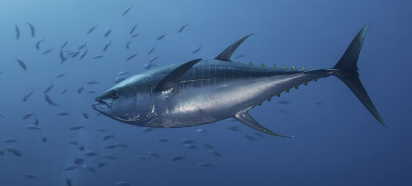
Although shipping and seabed mining are current and emerging threats to high sea biodiversity, they were not
considered in this analysis. Seabed mining claims in areas beyond national jurisdiction were not considered
because they are still in the exploratory stage and mining has yet to begin on a commercial scale. Conversely, the
shipping industry has a global footprint that affects most of the high seas (see Figure 1). Although this analysis
could support decisions to adopt measures that would minimize the negative impact of shipping in important
high seas areas, those areas with high levels of shipping traffic were not removed from consideration.
Figure 1
Multiple Factors Determine Possible High Seas Protected Areas
Analysing conservation features highlights benefits of certain waters
Seamounts
Seamounts
and vents and
hydrothermal vents
Priority areas
Species for protection
Priority areas
Ocean
richness for protection
Productivity
Seafloor
habitat
Species
diversity
Richness
Seafloor
Ocean
habitat
productivity
diversity
These maps represent an area of roughly 562,500 sq km
(217,200 sq mi) surrounding the Corner Rise Seamounts
Note: This figure is a simplified version of the data methods used. There were in total 54 different layers of data, grouped into
six broad conservation features: species richness, species extinction risk, seamounts, hydrothermal vents, seafloor habitat
diversity, and productivity.
Sources: UCSB analysis. Analysis underwent technical verification and was confirmed to be reproducible; P. Harris and
T. Whiteway, “High Seas Marine Protected Areas: Benthic Environmental Conservation Priorities From a GIS Analysis
of Global Ocean Biophysical Data,” Ocean and Coastal Management 51, no.1 (2009): 22-38, https://doi.org/10.1016/j.
ocecoaman.2008.09.009; GEBCO
© 2020 The Pew Charitable Trusts
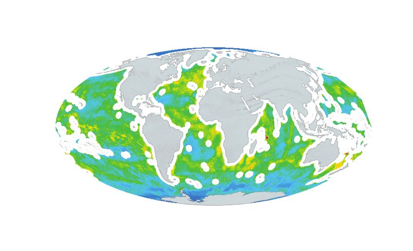
8Map 2
Visualization of Conservation Features Across the Oceans
Certain areas have higher concentrations and are well-suited for protections
Lower density of conservation features Higher density of conservation features
Note: Areas with a lower density of conservation features should not be seen as unworthy of protection. The science suggests
that consideration should be given to safeguarding marine areas rich in even a single conservation feature.
Sources: UCSB analysis. Analysis underwent technical verification and was confirmed to be reproducible. Marineregions.org;
Natural Earth
© 2020 The Pew Charitable Trusts
A tool to ensure conservation targets are met
Researchers relied on the prioritizr tool to ensure that conservation targets are met while minimizing the costs
of the conservation solution. For each of the 54 data layers described above, the tool was set to select a solution
area that protected at least 30 per cent of the conservation features in each individual layer while minimizing
overlap with highly fished areas. Map 3 shows the result of that process. In Map 3, those areas that met the
conservation target but were removed because they were places with high concentrations of fishing effort—and
therefore higher costs—are shown in red.
9Map 3
High Seas Areas That Meet 30% Conservation Objective
Some of the most biodiverse places also tend to be commercially important
Prioritizr solution protecting 30 per cent Areas that would have been included in the solution
of conservation features but were excluded because they are highly fished
Note: Prioritizr tool selected solution areas that would protect at least 30 per cent of each of those 54 conservation features
while minimizing overlap with highly fished areas.
Sources: UCSB analysis. Analysis underwent technical verification and was confirmed to be reproducible. Marineregions.org;
Natural Earth
© 2020 The Pew Charitable Trusts
Results: Important areas to protect in the high seas
The high seas and their biodiversity are critical to the health and ecosystem function of the global ocean and
therefore should be protected and used sustainably. This work can serve as a starting point in building towards a
goal of safeguarding at least 30 per cent of the ocean in a network of well-connected MPAs.
Many areas known for their extraordinary biodiversity or other conservation features are included in the results.
One particularly productive and extraordinary area is the Barents Sea, a relatively shallow area of the Arctic
Ocean where the warm Atlantic water carried northward by the Gulf Stream meets the cold Arctic waters.
Animals follow the ice north as it melts, and at least 20 million seabirds reside in this area each summer.34
10Meanwhile, at the southern pole, the krill-rich waters of the Antarctic also featured in the conservation
solution. Portions of the Southern Ocean near Antarctica already benefit from protections established by
the Commission for the Conservation of Antarctic Marine Living Resources (CCAMLR), the international
organization that manages these waters.
This report explores 10 other sites that represent the extraordinary value of the high seas areas worthy of
protection based on the findings of the UCSB study (see Map 4).
Map 4
Special Places in the High Seas Span the World’s Oceans and Regions
Areas with high concentrations of conservation features worthy of protection
Sargasso Sea
and Corner Rise
Seamounts Emperor
Arabian Seamount Chain
Costa Rica Sea
Dome Gulf of
Guinea
Mascarene
Plateau Lord Howe
Salas y Gómez and Rise
Nazca Ridges Walvis
Ridge South
Tasman Sea
Sources: UCSB analysis; Marineregions.org; Natural Earth
© 2020 The Pew Charitable Trusts
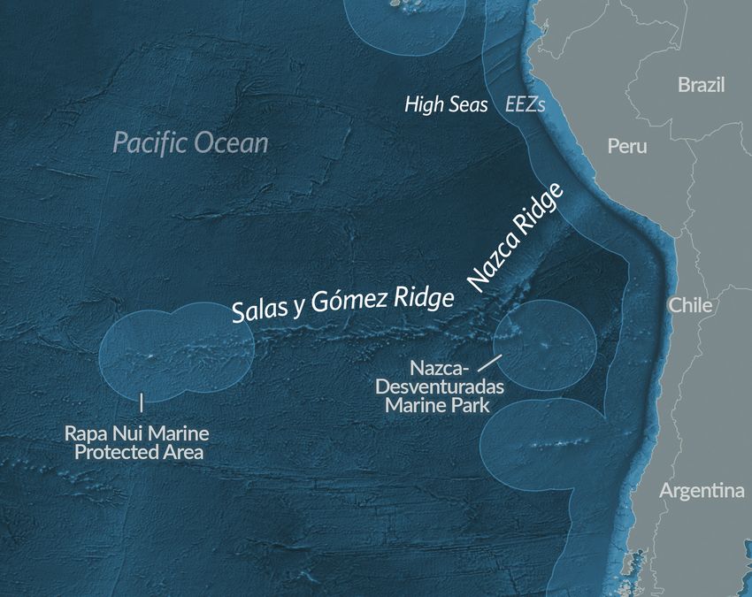
11Salas y Gómez and Nazca Ridges
The Salas y Gómez and Nazca Ridges are connected submarine mountain ranges in the southeastern Pacific
Ocean with the peak between them located about 2,000 kilometres from mainland Chile. Together they
extend nearly 3,000 kilometres (1,864 miles), or roughly the distance from Maine to Florida, and contain
at least 110 seamounts at fishable depth in areas beyond national jurisdiction, about 40 per cent of all
seamounts in this region of the Pacific.35 Because fishing and other extractive activities in the area have so
far been limited, these deep-sea mountains contain some of the world’s highest levels of endemic marine
biological diversity and could be important for the survival of still-undiscovered species.36 The seamounts
offer refuge to both resident and migratory species, including threatened blue whales and leatherback sea
turtles that return to these waters annually to breed and feed.37
The South Pacific Regional Fisheries Management Organisation (SPRFMO) oversees conservation and
sustainable use of fishery resources in this region of the Pacific, about a quarter of the Earth’s total high
seas area. The target species managed by this RFMO include orange roughy, alfonsino, and jack mackerel,
and fishing methods in use include purse seining, pelagic trawling, jigging, bottom trawling, and bottom
longlining.38 Trawling in particular has historically had a devastating impact on seafloor habitat.39
In recognition of the area’s biological importance, Chile has designated two areas within its adjacent
national waters—the Nazca-Desventuradas Marine Park to the east and the Rapa Nui Marine Protected
Area surrounding Easter Island to the west. As technology for fishing on the high seas improves and coastal
stocks are further exploited, destructive bottom fishing in the region could increase.
ACEgan/Shutterstock
Seamounts in these waters offer refuge to both resident and migratory species, including leatherback sea turtles.
12Species
richness
Endangered
species
Mauricio Handler/National Geographic
A migratory blue whale, which returns to these waters to breed, feeds on krill. Seamounts
Sources: Marineregions.org; GEBCO; Natural Earth
© 2020 The Pew Charitable Trusts
13Rodrigo Friscione/Getty Images
The nutrient-rich waters of the Costa Rica Dome attract a high diversity of species, including yellowfin tuna.
Costa Rica Dome
A dynamic feature in the eastern tropical Pacific Ocean, the Costa Rica Thermal Dome is formed through a
unique interaction of surface winds and surrounding ocean currents that drive deep, cold, nutrient-rich water
up towards the warmer surface. Because of the dynamic nature of both surface winds and ocean currents,
the dome fluctuates seasonally in its location, though it maintains a relatively constant average position in
areas beyond the jurisdiction of Central America’s nations.
The upwelling of nutrient-rich waters drives an explosion of productivity that, in turn, attracts a high
diversity of species that feed on the readily available and abundant food. Migratory marine predators such
as tuna, dolphins, and cetaceans gather seasonally in these waters to feed. The area is also critical habitat
for endangered blue whales and leatherback sea turtles. Under future climate scenarios, the Costa Rica
Dome could prove even more critical as a habitat for an increasing number of vulnerable and threatened
species in a warmer ocean.40
Efforts are underway to protect the Costa Rica Dome area within national waters and on the high seas in
recognition of the uniqueness of its ecological drivers and the life it supports.41 Fishing effort, however,
remains a concern, a reality that is complicated because the dome moves with the seasons and is partially
within the national waters of Central American countries for about half of the year. With commercial and
recreational fishing, as well as wildlife tourism, having a strong presence in the area, life within the dome
faces many threats from human activities as it moves between international and domestic waters.
In 2009, the region’s fishing industry brought in approximately US$750 million.42 Notably high marine
traffic poses threats of whale strikes, pollution, and other concerns. Given the area’s importance for marine
biological diversity, protection of these waters would ensure the long-term survival of the species that live
there—and the sustainability of the industries that rely on them.
14Ocean
productivity
Species
richness
Sources: Marineregions.org; GEBCO; Natural Earth
© 2020 The Pew Charitable Trusts
Endangered
species
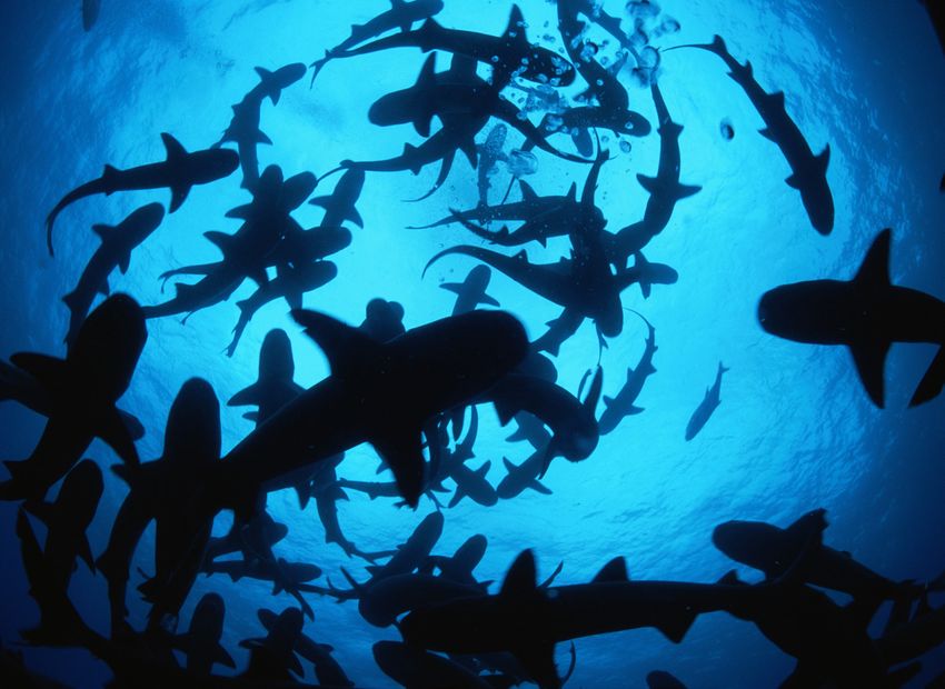
Jeff Rotman/Getty Images
Marine predators such as these white tip reef sharks feed on the readily available and abundant life in the
Costa Rica Dome.
15Dan Mantle
Seabirds such as this Gould’s petrel, a threatened species, are abundant in the waters of Lord Howe Rise and South Tasman Sea.
Lord Howe Rise and South Tasman Sea
Nestled between the EEZs of Australia and New Zealand, the Lord Howe Rise and South Tasman Sea
are among the most biodiverse and productive waters beyond national jurisdiction. Together they act as
stepping stones along a migratory corridor for marine megafauna such as humpback whales, offering refuge
from predators and rich breeding and feeding grounds.
The Lord Howe Rise is a deep-sea plateau directly east of Brisbane. With complex seafloor habitat, the area
is known for high species richness. An abundance of threatened species, such as the Gould’s petrel, use
these waters as a feeding ground. Scientists expect that more threatened species will be found in this area
as waters warm under future climate scenarios.43
The South Tasman Sea, just south of the Lord Howe Rise, includes some of the most productive waters
on the high seas. A high number of threatened species, such as black corals, can be found there.44 With
important seafloor habitat, including seamounts, species such as humpback and southern right whales use
these areas as pit stops between breeding and feeding grounds.
16Various international organizations and bodies have recognized the importance of
the region,45 and those tasked with managing its resources have identified areas of
unique importance. SPRFMO manages active bottom fisheries in the region and has
identified multiple vulnerable marine ecosystems (VMEs) for the predicted presence
of both octocorals and hard corals at fishable depths within its jurisdiction. But to
date, no comprehensive protections have been put into place. Despite the high Ocean
probability that rare and fragile corals live in these waters, almost none of the area is productivity
closed to bottom fishing.
Existing protections are limited to a “move on rule,” which requires fishing operations
to move their activities should they encounter deep-water coral or other indicators
that they are approaching a VME and share the location of the VME with fisheries
managers.46 SPRFMO considers these protocols interim measures until other
Species
management arrangements are established.47 richness
Recognizing the significance of the Lord Howe Rise and South Tasman Sea, Australia
and New Zealand both have safeguarded adjacent domestic waters, including
Lord Howe and Gifford protected areas in Australia and the Norfolk Deep benthic
protected area in New Zealand’s waters.48 Increasing protections to ensure ecosystem
connectivity in this area would protect this unique habitat and its diverse inhabitants.
Endangered
species
Seamounts
Benthic
heterogeneity
Sources: Marineregions.org; GEBCO; Natural Earth
© 2020 The Pew Charitable Trusts
17Emperor Seamount Chain
Arching northwest of the Hawaiian Islands toward Russia, the Emperor Seamount Chain is a productive and
highly biodiverse series of seamounts in the northwest Pacific.49 Formed by volcanic hot spot tracks, the
chain’s seamounts create an oceanographic boundary driving an upper water column whirlpool that attracts
pelagic species for spawning and adult habitat.50
Recent studies show that these seamounts support high levels of species richness and the presence of
threatened species, including deep-sea cold-water coral communities. Such corals are most diverse in
bathyal habitats—waters between 800 and 3,500 metres deep, roughly double the maximum depth of the
Grand Canyon.51 The Emperor Seamount Chain is the only range of seamounts between the Hawaiian and
the Aleutian islands with such species. Because of their deep-sea habitat, these cold-water corals grow
slowly and have a lower level of resiliency than their coastal analogs. That makes them especially vulnerable
to activities such as bottom fishing.52
The value of the Emperor Seamount Chain ecosystem has been recognized by individual nations and
international entities. The southernmost portion of the chain falls within U.S. national waters and is
protected as Papahānaumokuākea Marine National Monument, one of the world’s largest MPAs and
a UNESCO World Heritage site.53 But the northern Emperor Seamount Chain in areas beyond national
jurisdiction has historically faced high fishing pressure along its seamounts and continues to face pressure
from bottom fisheries.
Fishing conservation measures along the chain have been limited to interim steps by the North Pacific
Fisheries Commission that maintain existing effort levels but limit the geographic scope of bottom fisheries.
The Commission has granted exceptions if interests demonstrate they can fish without jeopardizing the
environment.54 Protecting the extent of the Emperor Seamount Chain would afford conservation benefits to
the entire ecosystem, not only those areas under national jurisdiction.
NOAA Office of Ocean Exploration and Research, 2015/Flickr Creative Commons
This commensal brittle star on a deep-sea pink sea coral lives in the Emperor Seamount Chain, which supports high levels of species richness,
including deep-sea cold-water coral communities.
18Ocean
productivity
Species
richness
NOAA Office of Ocean Exploration and Research, 2016 Hohonu Moana/Flickr Creative Commons
This purple crinoid has grown attached to a dead coral stalk. The value of the Emperor Seamount Chain
ecosystem has been recognized internationally. Endangered
species
Seamounts
Sources: Marineregions.org; GEBCO; Natural Earth
© 2020 The Pew Charitable Trusts
19Imogen Warren/Shutterstock
Seabirds, such as this wedge-tailed shearwater, benefit from ocean productivity enhanced by the interaction of the Mascarene Plateau with
the South Equatorial Current.
Mascarene Plateau
Sometimes referred to as the Seychelles-Mauritius Plateau, the Mascarene Plateau in the Indian Ocean arcs
from the northern Seychelles Bank down to St. Brandon Island of Mauritius in the south. With areas reaching
less than 20 metres deep, the Mascarene Plateau is home to one of the few very shallow water coral reef
ecosystems in the high seas, and one of the only regions of seagrasses in such waters.55 The Saya de Malha
Bank, in the central portion of the plateau, supports the largest contiguous seagrass beds in the world: 80 to
90 per cent of shallow surfaces are covered by seagrasses.56
The interaction of the plateau with the South Equatorial Current causes enhanced oceanic productivity. This,
in turn, supports seabirds such as the wedge-tailed shearwater and marine mammals such as the pygmy
blue whale, which uses the area as a breeding and feeding ground.57 Much is still to be discovered on the
Mascarene Plateau, but the unexplored areas here are likely to have high species endemism because of the
region’s unique oceanographic features and habitats.58
Many international bodies have recognized the significance of the Mascarene Plateau and the surrounding
area. Protection of the plateau, therefore, could help protect some of these unique and important
ecosystems by expanding on conservation efforts in the region.59
Despite the ecological importance of the Mascarene Plateau, interests are working to exploit the area’s
resources for commercial purposes. In 2018, the Joint Commission of the Mauritius-Seychelles Extended
Continental Shelf, Mascarene Plateau region opened the joint management area (JMA) for oil and gas
exploration.60 The commercial fishing industry remains interested in bottom fishing area seamounts as
well.61 To ensure the long-term viability of such a crucial habitat, the Mascarene Plateau would benefit from
dedicated international protection and commitment to conservation.
20Ocean
productivity
Species
richness
Sources: Marineregions.org; GEBCO; Natural Earth
© 2020 The Pew Charitable Trusts Endangered
species
Benthic
heterogeneity
Rainer von Brandis/Getty Images
The Mascarene Plateau supports one of the only areas of high seas seagrasses, which turtles like this one
call home.
21Arabian Sea
Part of the northern Indian Ocean, the Arabian Sea sits just southeast of the Arabian Peninsula. A combination
of features in the region, including the sea’s geographically restricted, highly saline and warm surface waters,
drives the stratification of oxygen in the water column. These waters beyond the EEZs of India, Pakistan,
Oman, and Yemen house what is known as an extreme oxygen minimum zone (OMZ), a distinct and rare
feature, between depths of 200 to 1,000 metres, or around as deep as Dubai’s Burj Khalifa building is tall.
An extreme OMZ is indicative of a highly populated space in the water column with a high level of oxygen
consumption by species present, which leads to nearly no freely available oxygen available to the rest of the
ecosystem.
Hospitable to unique fauna such as lanternfishes, flying squid, and pelagic crabs, these Arabian Sea waters
have an unusually high presence of mesopelagic animals that travel up and down daily through the water
column in search of food and protection. The zone is also home to unique deep-sea creatures that have
adapted to such low oxygen conditions as well as large predators such as squids, ribbonfishes, tuna, and
billfish that rely on the mesopelagic animals as a key food source.62 Scientists also have identified the
Arabian Sea as an important place for both cetacean and shark populations.63 In addition to its high levels
of productivity, the sea has remarkable bathymetric features, including hydrothermal vents and several
seamounts.64
The uniqueness of this area has been recognized through international designations as well as recent regional
conservation efforts.65 Pakistan designated its first MPA in the Arabian Sea on Astola Island in 2017, with
a focus on protections for Arabian Sea humpback whales. India, Yemen, Oman, and Somalia have all also
established domestic protected areas in their waters, highlighting an opportunity to connect critical habitat
in the region.66 Although there is some fishing in the area, marine biodiversity in the Arabian Sea is mostly
threatened by vessel pollution and spills, as well as marine mammal strikes in a highly trafficked area.67
Visuals Unlimited Inc./David Wrobel/Getty Images
The deep waters of the Arabian Sea are hospitable to lanternfish, a bioluminescent fish with light-producing organs.
22Ocean
productivity
Species
richness
NOAA MESA Project/Flickr Creative Commons
Phytoplankton are the foundation of the oceanic food chain and are present in vast numbers in highly
productive areas, such as in the Arabian Sea. Endangered
species
Seamounts
Hydrothermal
vents
Sources: Marineregions.org; GEBCO; Natural Earth
© 2020 The Pew Charitable Trusts Benthic
heterogeneity
23Gulf of Guinea
Off the central west African coast, the Gulf of Guinea is a biological hot spot. Powerful upwelling and the
convergence of three separate currents drive some of the highest levels of productivity in the high seas.
Sediment and nutrients from the Congo River also contribute to the productivity.
Many high seas areas face upper limits on their productivity dictated by the availability of certain nutrients.
The influx of nutrient-rich waters from the Congo River helps to ensure that this ecosystem’s productivity is
not affected by a scarcity of essential nutrients.
Sirachai Arunrugstichai/Getty Images
Various species of rays, such as the manta ray above, as well as tuna, swordfish, and shark species grow and live in the waters of the
Gulf of Guinea.
24Ocean
productivity
Species
richness
Sources: Marineregions.org; GEBCO; Natural Earth Endangered
species
© 2020 The Pew Charitable Trusts
These waters support habitat critical for migration and reproduction of
commercially and biologically important species, such as bigeye and yellowfin tuna.
Larvae and juveniles, as well as adults, of many species of tuna, swordfish, sharks,
and rays all use these waters for their development.68 The area provides habitat Benthic
for many large marine mammals, including humpback whales, sperm whales, and heterogeneity
melon-headed whales.69
Despite its biological importance, the Gulf of Guinea faces serious threats from
illegal and unregulated fishing, as well as piracy.70 Experts estimate that more
than 50 per cent of fisheries resources from the Nigeria to Senegal coasts are
overexploited and that the amount of illegal, unregulated, and unreported fishing
is the equivalent of 65 per cent of the legal reported catch for the Gulf of Guinea.71
In 2018, the Gulf of Guinea had the highest rate of piracy incidents of any region,
accounting for about 40 per cent of all worldwide that year.72 The compounding
threats to ocean resources jeopardize the sustainability of the region’s fisheries as
well as the unique and endangered species found there.
25Walvis Ridge
The Walvis Ridge is an undersea mountain range that formed as a result of a volcanic hot spot track off the
southwestern tip of Africa. Running northeast from Tristan da Cunha, a U.K. overseas territory, towards
Namibia, the ridge serves as a barrier—as well as a point of mixing—between North Atlantic deep water and
Antarctic bottom water that supports a diverse biological community and high levels of species richness.
The area has a high diversity of seafloor features that support a wide array of life.
In addition to seamounts, the area includes a variety of seafloor features such as steep canyons,
embayments, abyssal plains, and fossilized cold-water coral reef communities.73 This variation in the
slopes, summits, and surface waters supports a varied ecological community, one likely to be of particular
importance for vulnerable species associated with the ridge’s seamounts.74
The fishing footprint is relatively small in the region, and some of the seamounts are off-limits to bottom
fishing—in recognition of their ecological value—through the designation of VME fishery closures. The
significant value of the Walvis Ridge, supported by scientific recommendations for a precautionary approach
to its use, warrants international protections to safeguard a unique and important habitat from irreversible
damage.
Greg Lecoeur/National Geographic
A pod of dusky dolphins swims in deep water. The variation in the slopes, summits, and surface waters of the Walvis Ridge supports a diverse
ecological community.
26Ocean
productivity
Species
richness
Jim Brandenburg/Minden Pictures/National Geographic
The significant value of the Walvis Ridge warrants international protections to safeguard a unique and
important habitat from irreversible damage. Endangered
species
Seamounts
Benthic
heterogeneity
Sources: Marineregions.org; GEBCO; Natural Earth
© 2020 The Pew Charitable Trusts
27Masa Ushioda/BluePlanetArchive.com
This loggerhead sea turtle hatchling finds shelter among Sargasso weed, a brown alga. Various migratory species feed off the diverse
communities of smaller organisms living in the sargassum.
Sargasso Sea and Corner Rise Seamounts
The Sargasso Sea and Corner Rise Seamounts are located in the central to western Atlantic. An important
habitat largely defined by its characteristic sargassum seaweeds and the diverse ecosystem it supports, the
Sargasso Sea has ecological importance rivaled by few places in the world. Geographically defined by its
surrounding currents, the sea provides habitat for many critically important and endemic species, such as
European and American eels.75
It offers broader benefits by supporting global oceanographic processes such as carbon sequestration and
oxygen production.76 At some point in their lifetimes, 100 species of invertebrates, more than 280 species of
fish, and some 23 types of birds use the sea’s sargassum for protection, food, spawning, or nursery habitat.
These include 10 species found nowhere else on the planet, such as the sargassum angler fish, which has
camouflage uniquely adapted to these floating forests.
Other migratory species, such as tuna and marlin, feed off the diverse communities of smaller organisms
living in the sargassum, making this area critical to the productivity of commercial fisheries throughout
the Atlantic. The value of these fisheries has been estimated at about US$100 million per year.77 Along
the northeastern portion of the Sargasso Sea, the Corner Rise Seamounts includes a chain of underwater
28mountains that rise to within 200 metres of the surface. These waters harbor
complex faunal assemblages, including corals and sponges, as well as many
threatened or vulnerable species. Hydrothermal vents and the productive waters
that surround the steep slopes of the Corner Rise Seamounts support more than 175
species of fish.78
Ocean
Fisheries closures, in the form of VMEs, dot many of the area’s seamounts, productivity
protecting them from bottom fishing through 2020.79 But with a large historic
fishing footprint among the seamounts and only temporary protections, the region
could face fishery exploitation.80 Other potential risks include mining and vessel
traffic, which create a need to manage invasive species from ballast water.
The area has been recognized for its uniqueness and its contributions to global
ocean processes. The Sargasso Sea Commission has been working to promote Species
richness
better understanding of this ecosystem and coordinate regional and sectoral
conservation efforts. The Commission’s work has brought together a number
of governments and partners to secure adequate protection for this exceptional
ecosystem. However, without an overarching governance mechanism for
comprehensive protection in areas beyond national jurisdiction, the efforts to
protect the Sargasso Sea remain cumbersome and fragmented across many
different international bodies.81 Endangered
species
Seamounts
Hydrothermal
vents
Sources: Marineregions.org; GEBCO; Natural Earth
© 2020 The Pew Charitable Trusts
29A new treaty can spur creation of high seas MPAs
Today, a patchwork of international bodies and treaties manages resources and human activity in areas beyond
any state’s national jurisdiction. These organizations, which oversee activities such as fishing, whaling, shipping,
and seabed mining, vary greatly in their mandates, which determine their geographic scope, objectives, the
legally binding nature of their decisions, and what activities they regulate. Their jurisdictions often overlap, and,
too often, this piecemeal approach leads to degradation of the environment and its resources.
It also makes deploying management and conservation tools such as MPAs challenging both legally and
logistically.82 Ongoing negotiations at the United Nations on a high seas treaty offer an opportunity to address
current gaps in ocean governance to allow for comprehensive protection of marine biodiversity in the high seas.
To ensure that current and future generations continue to reap benefits from the high seas, the agreement must
include a global mechanism to establish a network of well-connected and representative high seas MPAs.
A new international agreement should provide the following:
• A global mechanism to identify and establish high seas MPAs. Setting up a central decision-making body
through which States can propose and agree on the establishment of MPAs in these waters would provide a
path towards creating such zones.
• A framework for adopting meaningful conservation objectives and enforceable management plans.
Maintaining the current approach would be ineffective because most of the sectoral bodies lack the
needed expertise or a mandate to protect biodiversity. High seas MPAs created with concrete objectives,
management plans, and enforcement protocols are more likely to protect biodiversity than areas
established without such specific parameters.
• A means of consulting and collaborating with sectoral and regional organizations. Under the new
instrument, parties should be able to formally consult with existing sectoral bodies and similar
organizations. These consultations would help to avoid conflict between management measures adopted
under the new treaty and pre-existing obligations to those organizations. States can encourage such
organizations to adopt complementary measures recognizing high seas MPAs but should not allow these
efforts to delay establishment or implementation of such MPAs.
• The tools to ensure effective implementation. The new agreement should help with the effective
implementation of MPAs by obliging parties to ensure that vessels and activities under their jurisdiction
abide by relevant management measures and report instances of non-compliance. A body established by
the treaty should monitor implementation and compliance. To ensure better enforcement, monitoring, and
data-sharing, the agreement should facilitate capacity building and the transfer of marine technology.
The task of protecting the high seas starts with identifying important places in the ocean that need protection.
Notable intergovernmental efforts include the regionally based, expert-driven process to identify ecologically and
biologically significant areas (EBSAs) under the Convention on Biological Diversity (CBD)83 as well as UNESCO
World Heritage sites. UNESCO encourages the protection of areas of outstanding cultural or natural value.84 As
of 2016, over 65 EBSAs either partially or entirely in the high seas have been identified.85
Other studies also have endeavored to identify special places in the ocean.86 Although the approach used in this
analysis differs from those efforts, it identified many of the same areas. This underscores that scientists and
decision makers have the information, data, and tools to readily identify areas of biological importance in areas
30beyond national jurisdiction. So, although there is still much to understand and discover about the half of the
planet that makes up the high seas, limits on scientific information cannot be an excuse for inaction.
Some of these areas have benefited from limited single-sector protections such as stricter fishing regulations,
while others have gained from special cooperative efforts by adjacent coastal nations to conserve or sustainably
use their waters. However, the state of the ocean continues to decline. The global community must improve upon
the status quo of ocean governance by finalizing a robust and ambitious high seas treaty.
Conclusion
The high seas teem with marine life. They act both as habitats and thoroughfares for migratory species and
benefit from unique features and ecological processes that provide the cornerstones of communities of untold
numbers of rare and endemic species. This report provides a brief tour of particularly valuable high seas areas
that would benefit from comprehensive protections such as those envisioned in the negotiations for a new
high seas treaty. The analysis led by the UCSB researchers demonstrates that although there is still much to
be discovered in areas beyond national jurisdiction, there is enough scientific data available to be able to start
identifying sites that would make excellent high seas MPA candidates.
Because the health and functioning of the ocean is declining at an alarming rate, the world’s governments must
take bold and urgent action to ensure that the ocean continues to provide the benefits and resources upon
which so many depend. Those include resilience to climate change, maintenance of ecosystem functions, and
conservation of marine life and healthy fish stocks. High seas MPAs can help meet these objectives, but currently
there is no legal mechanism in place for establishing comprehensive, multisector protected areas.
A new high seas treaty offers an opportunity to create such a tool, and policymakers should come to terms on a
robust global agreement to ensure the conservation and sustainable use of marine biodiversity for current and
future generations.
31Appendix: Methodological details Key factors and methodology The analysis by researchers at UCSB relied on prioritizr R, a systematic conservation prioritization software that identifies protected area solutions that meet conservation objectives while minimizing the “cost” associated with conserving these regions. The algorithm is set up to select specific areas that meet a variety of conservation objectives while avoiding those areas with a high “cost” associated with them (in this exercise, areas with high concentrations of fishing were considered “high cost”). The system has similar functionality to the Marxan conservation planning program, although prioritizr uses exact algorithms to find optimal conservation solutions. For this analysis, areas of the water column within any nation’s jurisdiction, typically known as the exclusive economic zones (EEZ), were removed. EEZ boundary data were obtained from MarineRegions.org. This approach is consistent with other studies focused on high seas areas.87 The resulting areas were then divided into 50.1 kilometre x 50.1 kilometre square planning units. Six conservation feature layers were used in the algorithm: species richness (both now and in a climate-future scenario), species extinction risk (both now and in a climate- future scenario), seamounts, hydrothermal vents, seafloor habitat diversity, and productivity; the analysis also included one cost layer (fishing effort). The data layers were overlaid with the planning units, and the prioritizr tool algorithms determined whether that planning area should be included in the conservation solution. The prioritizr tool ensures that all conservation objectives are met in the targeted areas while minimizing the costs of the conservation solution. The tool was set to select a solution area that protected at least 30 per cent of the conservation features in the 54 individual data layers while minimizing overlap with highly fished areas. Species richness To capture the known organisms that exist, or are thought to exist, in specific areas, data from AquaMaps were used to determine species richness.88 AquaMaps predicts the relative probability of a species occurring in a given area based on environmental data such as depth, temperature, salinity, and the habitat preferences of that species. In this analysis, 11,900 species from the AquaMaps data were considered and grouped into 23 major taxonomic groups. To incorporate the projected impact of climate change, researchers used a similar method, examining data projections from the AquaMaps 2100 model. That model estimates where species are likely to occur in 2100, based on predictions of global climate change conditions. In the end, 46 different species richness layers were analyzed by the prioritizr function: 23 taxonomic groups in current ocean conditions, and the same groups under the climate-changed scenario. Species extinction risk The analysis also considered the vulnerability of those species to extinction. To capture this, the team used IUCN extinction risk data, excluding data-deficient species. The IUCN Red List categories were given a value (Critically Endangered=4, Endangered=3, Vulnerable=2, Near Threatened=1 or Least Concern=0); the Red List score for each of the species present in a given planning unit were assessed and then were added together. Researchers repeated this process for the AquaMaps 2100 distribution data, though this layer does not consider other drivers of extinction risk, such as ocean acidification. This resulted in two “species extinction risk” layers—one representing current species extinction risk, and another representing future risk under a climate-changed scenario. 32
You can also read