A reconstruction of the recent fire regimes of Majete Wildlife Reserve, Malawi, using remote sensing
←
→
Page content transcription
If your browser does not render page correctly, please read the page content below
Nieman et al. Fire Ecology     (2021) 17:4
https://doi.org/10.1186/s42408-020-00090-0
                                                                                                                                                       Fire Ecology

 ORIGINAL RESEARCH                                                                                                                                   Open Access

A reconstruction of the recent fire regimes
of Majete Wildlife Reserve, Malawi, using
remote sensing
Willem A. Nieman1,2* , Brian W. van Wilgen3 and Alison J. Leslie1

  Abstract
  Background: Fire is an important process that shapes the structure and functioning of African savanna ecosystems,
  and managers of savanna protected areas use fire to achieve ecosystem goals. Developing appropriate fire
  management policies should be based on an understanding of the determinants, features, and effects of prevailing
  fire regimes, but this information is rarely available. In this study, we report on the use of remote sensing to
  develop a spatially explicit dataset on past fire regimes in Majete Wildlife Reserve, Malawi, between 2001 and 2019.
  Moderate Resolution Imaging Spectroradiometer (MODIS) images were used to evaluate the recent fire regime for
  two distinct vegetation types in Majete Wildlife Reserve, namely savanna and miombo. Additionally, a comparison
  was made between MODIS and Visible Infrared Imager Radiometer Suite (VIIRS) images by separately evaluating
  selected aspects of the fire regime between 2012 and 2019.
  Results: Mean fire return intervals were four and six years for miombo and savanna vegetation, respectively, but
  the distribution of fire return intervals was skewed, with a large proportion of the area burning annually or
  biennially, and a smaller proportion experiencing much longer fire return intervals. Variation in inter-annual rainfall
  also resulted in longer fire return intervals during cycles of below-average rainfall. Fires were concentrated in the
  hot-dry season despite a management intent to restrict burning to the cool-dry season. Mean fire intensities were
  generally low, but many individual fires had intensities of 14 to 18 times higher than the mean, especially in the
  hot-dry season. The VIIRS sensors detected many fires that were overlooked by the MODIS sensors, as images were
  collected at a finer scale.
  Conclusions: Remote sensing has provided a useful basis for reconstructing the recent fire regime of Majete
  Wildlife Reserve, and has highlighted a current mismatch between intended fire management goals and actual
  trends. Managers should re-evaluate fire policies based on our findings, setting clearly defined targets for the
  different vegetation types and introducing flexibility to accommodate natural variation in rainfall cycles. Local
  evidence of the links between fires and ecological outcomes will require further research to improve fire planning.
  Keywords: fire frequency, fire intensity, fire probability, fire season, miombo, MODIS, savanna, VIIRS

* Correspondence: 17688132@sun.ac.za
1
 Department of Conservation Ecology and Entomology, Stellenbosch
University, Private Bag X1, Matieland, Western Cape 7602, South Africa
2
 Majete Research Programme, Majete Wildlife Reserve, P.O. Box 232,
Chikwawa 315100, Malawi
Full list of author information is available at the end of the article

                                        © The Author(s). 2021 Open Access This article is licensed under a Creative Commons Attribution 4.0 International License,
                                        which permits use, sharing, adaptation, distribution and reproduction in any medium or format, as long as you give
                                        appropriate credit to the original author(s) and the source, provide a link to the Creative Commons licence, and indicate if
                                        changes were made. The images or other third party material in this article are included in the article's Creative Commons
                                        licence, unless indicated otherwise in a credit line to the material. If material is not included in the article's Creative Commons
                                        licence and your intended use is not permitted by statutory regulation or exceeds the permitted use, you will need to obtain
                                        permission directly from the copyright holder. To view a copy of this licence, visit http://creativecommons.org/licenses/by/4.0/.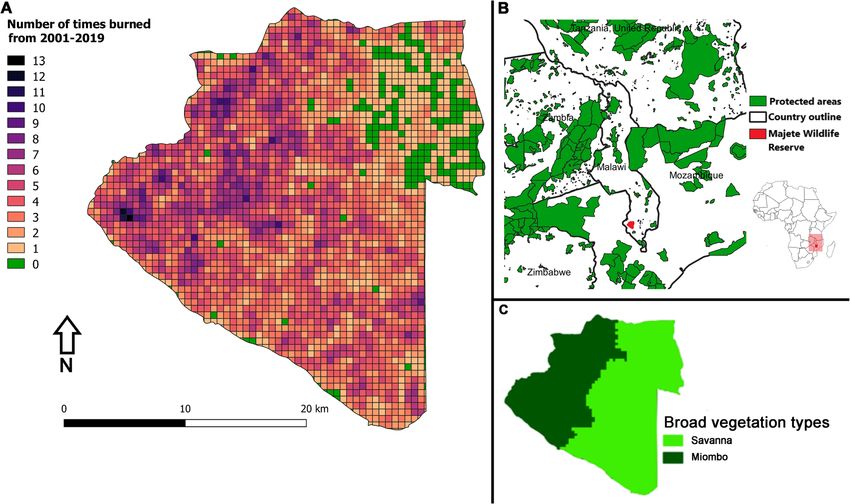
Nieman et al. Fire Ecology   (2021) 17:4                                                                     Page 2 of 13

 Resumen
 Antecedentes: El fuego es un proceso importante que moldea la estructura y el funcionamiento de los
 ecosistemas de sabana africanos, y los gestores de áreas protegidas de esas sabanas usan al fuego para lograr
 objetivos de manejo. Desarrollar políticas apropiadas de manejo deben estar basadas en un conocimiento de los
 determinantes, características, y efectos de regímenes de fuego prevalentes, aunque esta información raramente
 está disponible. En este estudio, informamos sobre el uso de sensores remotos para desarrollar una base de datos
 espacialmente explícitos sobre regímenes de fuegos pasados en la reserva de vida silvestre de Majete en Malawi,
 entre 2001 y 2019. Imágenes del satélite MODIS (Espectroradiómetro de Imágenes de Resolución Moderada) fueron
 usadas para evaluar el régimen reciente de fuego para dos tipos distintos de vegetación en la Reserva de vida
 Silvestre de Majete, denominadas savanna y miombo. Adicionalmente fue hecha una comparación entre imágenes
 de MODIS y VIIRS (Radiómetro de Imágenes en el Infrarrojo Visible), mediante la evaluación por separado de
 aspectos seleccionados del régimen de fuego entre 2012 y 2019.
 Resultados: Los intervalos medios de retorno del fuego fueron de cuatro y seis años para la vegetación del
 miombo y la savanna, respectivamente, aunque la distribución de los intervalos de fuego fue sesgada, con una gran
 proporción del área quemada en períodos anuales o bienales, y una pequeña proporción experimentando períodos
 de retorno del fuego mucho más largos. La variación interanual de la lluvia también resultó en períodos más largos
 de retorno del fuego durante ciclos de lluvias por debajo de la media. Los fuegos se concentraron en la estación
 cálida-seca a pesar de los intentos de manejo de restringir las quemas a los períodos secos y fríos. La intensidad
 media de los fuegos fue en general baja, aunque algunos fuegos individuales alcanzaron intensidades de 14 a 18
 veces más alta que la media, especialmente durante la estación cálida y seca. El sensor VIIRS detectó muchos
 fuegos que fueron pasados por alto por el sensor MODIS, dado que las imágenes fueron colectadas en una escala
 más fina.
 Conclusiones: Los sensores remotos proveyeron de una base muy útil para reconstruir el régimen de fuegos
 recientes de la reserva de vida silvestre de Majete en Malawi, y han subrayado un desfasaje corriente entre el
 manejo del fuego y las tendencias reales. Los gestores de recursos deberían re-evaluar las políticas de manejo del
 fuego basados en nuestros resultados, estableciendo metas claras y definidas para los distintos tipos de vegetación
 e introducir una flexibilidad para acomodar la variación natural en los ciclos de lluvias. La evidencia local de las
 ligazones entre los fuegos y los resultados ecológicos requerirá de más investigaciones para mejorar los planes de
 quemas.

Abbreviations                                                information on fire regimes has been documented
FRI:   Fire Return Interval                                  for a few African protected areas (PAs; Scholes and
FRP:    Fire Radiative Power                                 Walker 1993; van Wilgen et al. 2000; Brockett et al.
MODIS: MODerate resolution Imaging Spectroradiometer         2001; Eby et al. 2015; Archibald et al. 2017). The
MW: MegaWatts                                                majority of PAs, however, particularly those smaller
MWR: Majete Wildlife Reserve                                 in size, have very little or no information on past
PA:    Protected Area                                        fire regimes or fire management practices. This lack
VIIRS: VIsible Imager Radiometer Suite                       of information means that decisions on whether,
                                                             how, and when to use fire can only be based on
Background                                                   general principles, rather than on an informed un-
Fire is an important process in savanna and wood-            derstanding of prevailing fire regimes and their ef-
land ecosystems, where it enables the coexistence of         fects in any given area (Forsyth and van Wilgen
woody and herbaceous plants by affecting nutrient            2008). Remote sensing provides a way to significantly
cycling, grass productivity, and tree recruitment            improve our understanding of past fire regimes in
(Bond and Keeley 2005; Anderson et al. 2007).                data-sparse environments and of the relationship be-
Changes to prevailing fire regimes can therefore alter       tween fire, climate, and vegetation (Goodwin and
the structure and functioning of these ecosystems            Collett 2014; Archibald and Hempson 2016).
(Higgins et al. 2007). Managers of savanna ecosys-              Malawi has an extremely dense human population in
tems in sub-Saharan Africa have thus used fire to            comparison to the rest of sub-equatorial Africa (~200
achieve a range of management goals for at least the         people km−2; NSOM UNPFA 2018), resulting in few fires
past 100 years (van Wilgen 2009), and detailed               occurring outside PAs due to conversion of the land to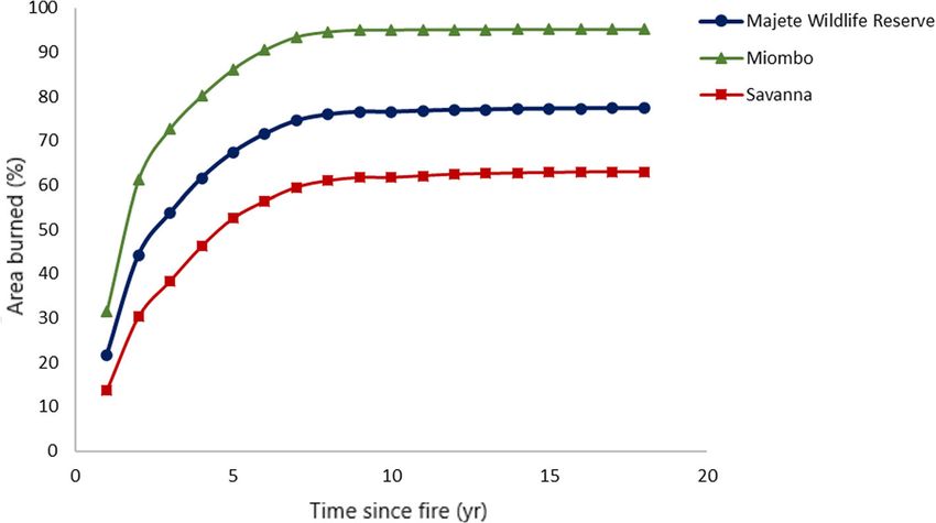
Nieman et al. Fire Ecology   (2021) 17:4                                                                         Page 3 of 13

crops, or due to overgrazing that removes grass fuels and,      Methods
as a result, 4000 kg ha−1. No fires were        and Julbernadia Pellegr. Grasses occur as an understory
allowed to be ignited after July, and 50% of the reserve was    of variable cover below the trees, or in open areas be-
allowed to burn per annum while all unplanned fires were        tween trees, but grasses are scarce in the northern sec-
actively suppressed. In 2014, the maximum target area to        tion of savanna, where most of the ground layer consists
be burned was reduced to 30%. Also in 2014, prescribed          of non-woody forbs.
fires were additionally set for the control of invasive alien     A variety of large herbivorous mammal species that
plants along the banks of the Shire River, notably for the      affect the structure of vegetation occur in MWR. These
control of Lantana camara L. The majority of mammal             include grazers (hippopotamus, Hippopotamus amphibi-
reintroductions were made in the northeastern section of        ous Linnaeus, 1758; buffalo, Syncerus caffer Sparrman,
MWR. Fires were actively suppressed in this area to protect     1779; sable antelope, Hippotragus niger Harris, 1838;
the animals, people, and infrastructure, and to reduce large    waterbuck, Kobus ellipsiprymnus Ogilby, 1833; warthog,
unsightly burns in tourist areas.                               Phacochoerus africanus Gmelin, 1788; and zebra, Equus
   Our research provides a spatially explicit assessment        quagga Boddaert, 1785), browsers (black rhinoceros,
of the recent fire regime of MWR between 2001 and               Diceros bicornis Linnaeus, 1758; giraffe, Giraffa camelo-
2019 using remote sensing. Additionally, the implica-           pardalis Linnaeus, 1758; and kudu, Tragelaphus strepsi-
tions for future fire management are explored for broad         ceros Pallas, 1766), and mixed feeders (elephant,
vegetation types in MWR. This is intended to aid in the         Loxodonta africana Blumenbach, 1797; eland, Tragela-
development of appropriate fire management practices            phus oryx Pallas, 1766; impala, Aepyceros melampus
and policies that in turn will promote the achievement          Lichtenstein, 1812; and nyala, Tragelaphus angasii
of conservation goals.                                          Angas, 1849).
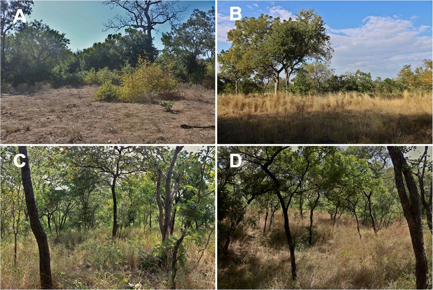
Nieman et al. Fire Ecology       (2021) 17:4                                                                                                  Page 4 of 13

 Fig. 1 Broad vegetation types of Majete Wildlife Reserve, Malawi. (A, B) Savanna (note in A the decrease in grass, and increase in non-woody
 forbs, due to intense grazing pressure). (C, D) Miombo. Photographer credit: W.A. Nieman (2020)

 Fig. 2 (A) Fire frequency (number of times burned between 2001 and 2019) calculated for 30 ha grid cells in Majete Wildlife Reserve, Malawi. Fire
 return intervals are shorter (i.e., fires are more frequent) in darker grid cells, and longer in lightly shaded grid cells. (B) Surrounding countries and
 protected areas. (C) A simplified vegetation map showing two broad vegetation types of Majete Wildlife Reserve. The vegetation map was based
 on plant distributions compiled by Sherry (1989)
Nieman et al. Fire Ecology   (2021) 17:4                                                                     Page 5 of 13


Fire information database                                              b
Fire occurrence data for MWR were obtained from               FRI ¼ y     ;                                          ð1Þ
                                                                       a
Moderate Resolution Imaging Spectroradiometer
(MODIS) images between January 2001 and Decem-             where FRI is the fire return interval in years, y is the
ber 2019, as well as from Visible Infrared Imager          number of years over which fires were recorded, b is the
Radiometer Suite (VIIRS) images between January            extent of all fires over y years, and a is the area over
2012 and December 2019. Specifically, the MCD14DL          which fires were recorded (van Wilgen et al. 2004). This
near real-time hotspot (MODIS Collection 6 NRT             statistic was calculated for the entire MWR, as well as
Hotspot / Active Fire Detections MCD14DL; https://         for the two broad vegetation types by overlaying the fire
earthdata.nasa.gov/firms), MCD45A1 burned area             records on a vegetation map.
(Giglio et al. 2018a), and VNP14IMGT active fire de-         Equation 1 gives a single value for FRI, but intervals
tection (NRT VIIRS 375 m Active Fire product;              can vary considerably between successive fires. An esti-
https://earthdata.nasa.gov/firms) products were used.      mation of this variability is therefore required. We esti-
Although newer versions of the MCD45A1 product             mated the fire frequency distribution around the mean
exist, the MCD45A1 algorithm has been shown to be          based on 30 ha grid cells. A grid cell was considered
more accurate at a finer scale, and more effective in      burned in any given year if >30% of the cell burned. We
mountainous terrain (Fornacca et al. 2017). The            then noted the length of FRIs between successive fires
MODIS database was also chosen because it provided         on each 30 ha grid cell. We discarded those cells that
an appropriate temporal resolution by capturing fires      never burned (or only burned once, and thus had no
on a daily basis. From these images, the location of       FRI), and counted the number of times that fire return
burned areas can clearly be seen, and since the im-        intervals of 1, 2, 3… n years occurred in the remaining
ages are taken on a daily basis, the date that the fire    cells (where n = the number of years for which data
started can be established by noting the first date that   were available). These data were then used to depict the
the burned area appears. The MODIS terra instru-           proportion of the area of all fires on record that oc-
ments started collecting data in April 2000 and can        curred at discrete FRIs. We also constructed curves
reliably detect flaming or smoldering fires of greater     depicting the probability of a grid cell experiencing a
than ~1000 m2. The VIIRS instruments started col-          subsequent fire at different post-fire ages, for MWR as a
lecting information in January 2012, with a much           whole, and for each of the two broad vegetation types,
higher spatial resolution (375 m2) than the MODIS          taking into account that a proportion of the area
sensors, and were thus able to detect smaller fires.       remained fire free, or only burned once, during the
The analyses reported in this paper are based on the       period examined.
MODIS data for the period 2001 to 2019. Selected
analyses were also repeated to compare MODIS with          Influence of inter-annual rainfall variability on area
VIIRS data for the period 2012 to 2019. The VIIRS          burned
dataset should reveal smaller fires typically overlooked   Total annual rainfall can be highly variable between
by the MODIS sensors. The MODIS information cap-           years in many African savanna environments. Years with
tured in 2000 was not considered since data collec-        relatively high rainfall promote the growth of grasses,
tion did not span the full year. Due to technical          which in turn provide more fuel for fires; the area that
errors on the MODIS satellite, burned area data for        burns in any given year is thus strongly influenced by
June 2001 were unavailable. We therefore patched the       preceding rainfall (van Wilgen et al. 2004; Archibald
data for June 2001 with estimates based on the values      et al. 2009). We obtained total rainfall for each year from
for June in other years, expressed as a ratio of the       1999 to 2018 for the 4755 km2 Chikwawa region in
values for areas burned in other months (Archibald         which MWR is situated (https://climateknowledgeportal.
et al. 2010). Information from both sensors was cap-       worldbank.org). A linear regression was then used to
tured and analyzed in a geographic information sys-        examine the relationship between the area burned each
tem (QGIS v3.10.2; http://www.qgis.org), and further       year and the mean rainfall over the preceding two years.
statistical analyses were performed in RStudio v1.2.5
(RStudio Team 2020). Management records of past            Fire seasonality
fires in MWR were incomplete, and thus not suitable        The total area that burned during each month was cal-
for use in any analyses.                                   culated, and the findings were interpreted in terms of
                                                           the three broad seasons (wet season, cool-dry season,
Fire frequency and fire probability                        and hot-dry season). Comparisons were made using a
The mean fire return interval (FRI) of MWR was calcu-      Kruskal-Wallis H test (Kruskal and Wallis 1952),
lated as:                                                  followed by a post hoc Wilcoxon rank sum test (Wilcoxon
Nieman et al. Fire Ecology (2021) 17:4 Page 6 of 13
1945). P-values were not adjusted and were considered two years (Fig. 3). Note that the difference between the
significant when P < 0.05. two estimates of area that burn annually (27.8% and
21.7%) is because the first is expressed as a percentage
Fire intensity of burned area, and the second as a percentage of the
The fire radiative power (FRP) estimate that is captured area of MWR, some of which did not burn at all. The
by the satellite instrument’s middle-infrared wavelength median probability of fire (i.e., the post-fire age at which
measurements represents the rate of radiant heat output 50% of the area will experience a subsequent fire) was
from a fire in megawatts (MW; Kaufman et al. 1996). A 2.6 yr, but the distribution is highly skewed and, al-
single value of the FRP is given for each individual fire, though short-interval fires predominate, some of the
and not per grid cell, irrespective of the period over area survives for five years or more without burning, in-
which the fire remained active, and is captured at the creasing the mean FRI. In addition, 22.9% of MWR ex-
time of satellite overpass. A mean was then calculated perienced only a single fire, or remained fire free, for the
for all fires that occurred in each month and season. entire study period.
The FRP can be associated with both fire intensity and At the level of individual vegetation types, it is clear
the rate of fuel consumption from a fire (Wooster et al. that miombo burns more frequently than savanna (Table
2005; Ichoku et al. 2008; Barrett and Kasischke 2013; 1, Fig. 3). In miombo, almost two thirds of the area that
Wooster et al. 2013). A high FRP value is thus associated burned either experienced a fire every year or every two
with high-intensity fires, which are typically larger in size years, while this was less than half in savannas. The me-
(Rogers et al. 2015). The intensity of fires (derived from dian probability of fire was 1.7 yr in miombo and 4.9 yr
the FRP value) occurring in different seasons and in in- in savanna, and a relatively large proportion (37.0%) of
dividual months in MWR were analyzed using a savanna experienced only a single fire, or remained fire
Kruskal-Wallis H test. Post hoc comparisons were made free, for the entire study period. The corresponding esti-
with the use of Wilcoxon rank sum tests. The P-values mate for miombo was only 2.1%.
were not adjusted and were considered significant when
P < 0.05. Influence of inter-annual rainfall variability on area
burned
Comparison of MODIS and VIIRS datasets The total rainfall recorded in individual years between
To compare the values given by the MODIS and VIIRS 1999 and 2018 ranged between 620 and 1168 mm. The
sensors for the period 2012 to 2019, the FRI, fire season, area that burned in MWR in any given year was influ-
and fire intensity was calculated for each dataset separ- enced by the mean rainfall recorded in the preceding
ately. The same methodology and statistical analyses as two years (Fig. 4; y = 44.5, x − 22 609, r2 = 0.30), and
described in the sections above for the MODIS (2001 to the area burned in a given year ranged from 3900 ha
2019) dataset were used. The number of fires and the (5.6% of MWR) following a period of below-average
area burned detected by each sensor during 2012 to rainfall, to 31 000 ha (44.3% of MWR) following a period
2019 was also compared. of above-average rainfall.
Results Fire seasonality
Fire frequency and probability The largest proportion of the area burned in the hot-dry sea-
A large number of fires occurred in each year in MWR son, and far less in the cool-dry season; fires were virtually
over the 19-year study period, averaging 153 fires per absent in the wet season (Fig. 5). The mean area burned dif-
year. Fires covered 282 900 ha over the 19 years in the fered between seasons in both the miombo (P < 0.0001) and
~70 000 ha MWR, giving an average of 14 889 ha the savanna (P < 0.0001). In both vegetation types, most of
burned per year. The estimated mean FRI for the entire the area burned during the hot-dry season (mean = 1919.3
MWR was 5.02 yr. Mean FRIs differed between broad ha month−1 and 1528.1 ha month−1 in the miombo and the
vegetation types, as well as between individual grid cells savanna, respectively, or 85.3% and 69.7% of the total area
(n = 2524; Fig. 2). Miombo (FRImean = 4.05 yr) burned burned annually), with fires in the cool-dry season covering a
more frequently than savanna (FRImean = 5.94 yr). much smaller area (mean = 328.4 ha month−1 or 14.6% and
A large proportion of the area of all fires on record 655.8 ha month−1 or 29.9%, respectively). Hardly any of the
burned either one (27.8%) or two (29.2%) years after a area burned in the wet season (mean = 2.63 ha month−1 or
preceding fire, and an additional 30.6% of the area 0.1% for miombo and 7.9 ha month−1 or 0.4% for savanna).
burned within three to five years after the preceding fire. The dry months (April to November) thus accounted for
Estimates of cumulative fire probability indicate that 99.9% and 99.6% of the annual burned area, for miombo and
21.7% of MWR experienced a subsequent fire after one savanna, respectively. In miombo, the area burned in each of
year, while 44.2% experienced a subsequent fire after the three broad seasons differed significantly (P < 0.001). InNieman et al. Fire Ecology (2021) 17:4 Page 7 of 13
Fig. 3 The cumulative probability of a fire over time in the entire Majete Wildlife Reserve, Malawi, in miombo vegetation and in savanna vegetation,
for 2001 through 2019
savanna, the area burned in the wet season differed 971.1 MW). The FRP values were significantly different be-
significantly from both the hot-dry and cool-dry sea- tween individual months for both the miombo (P < 0.001)
sons (P < 0.0001), but there was no significant differ- and savanna (P < 0.05) vegetation types. In miombo, the
ence between the two dry seasons (P > 0.05). highest-intensity fires occurred in October (mean = 51.7 ±
SE 4.5 MW) and November (mean = 55.5, SE = 17.1 MW),
Fire intensity while the lowest-intensity fires occurred in June (mean =
The mean intensity of fires was highest in the hot-dry 21.4, SE = 3.35 MW). No FRP values were recorded from
season, and lower in the cool-dry and the wet seasons January through April. In savanna, the highest-intensity
(Fig. 6). There was significant variation in FRP values be- fires occurred in October (mean = 55.5, SE = 7.3 MW) and
tween seasons in miombo (P < 0.01), with the highest- November (mean = 55.8, SE = 15.0 MW), while the lowest-
intensity fires occurring in the hot-dry season (mean = intensity fires occurred in December (mean = 24.4,
47.6, SE = 2.2 MW), followed by the cool-dry season SE = 9.4 MW). No FRP values were recorded from
(mean = 33.9, SE = 1.9 MW) and the wet season (mean January through March.
= 29.7, SE = 6.0 MW). The mean FRP was significantly
higher in the hot-dry season than in the other seasons Comparison of the MODIS and VIIRS datasets
(P < 0.01), but did not differ between fires in the More than four times as many fires (5570 fires) were de-
cool-dry and wet seasons (P > 0.05). The FRP values tected by the VIIRS sensors over an eight-year period
did not differ significantly between seasons in savanna (2012 to 2019) than were detected by the MODIS sen-
(P > 0.05), but occasional high-intensity fires did sors over the same period (1321 fires). Nonetheless, the
occur, particularly at the height of the hot-dry season MODIS sensors captured ~132 000 ha of burned area
(October). The highest FRP values for several fires in from 2012 to 2019, while the VIIRS sensors captured
the hot-dry season were up to 14 times greater than the ~78 000 ha. Consequently, for the period 2012 to 2019,
mean in savanna (maximum = 781.5 MW), and up to 18 the estimated mean FRI for MWR from the MODIS data
times greater than the mean in miombo (maximum = was 4.53 yr, compared to 7.67 yr from the VIIRS data.
Table 1 Proportion (%) of the area of all fires that burned at different fire return intervals in the entire Majete Wildlife Reserve, and
in two broad vegetation types, in Malawi, between 2001 and 2019
Fire return interval
Area 1 yr (%) 2 yr (%) 3 to 5 yr (%) 6 to 10 yr (%) >10 yr (%)
Majete Wildlife Reserve 27.8 29.2 30.6 11.8 1.1
Miombo 33.2 31.1 26.3 9.3 0.1
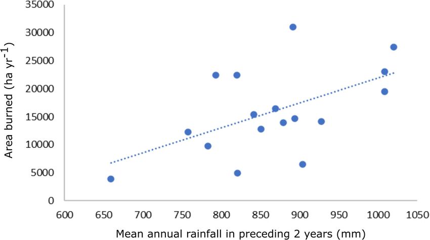
Savanna 21.8 26.2 35.4 14.5 2.1Nieman et al. Fire Ecology (2021) 17:4 Page 8 of 13 Fig. 4 Relationship between mean annual rainfall over the preceding two years and the total area burned in a given year in Majete Wildlife Reserve, Malawi for 2001 through 2019. Dots represent individual years, and the dotted line represents the overall relationship over all years The most reliable estimate was obtained by combining low in both datasets (0.4% and 0.4%, for MODIS and VIIRS, both the MODIS and VIIRS datasets for 2012 to 2019, respectively). The MODIS sensors gave a much thereby capturing the highest number of fires, and was larger estimate of area burned for each month given as 2.85 yr. (mean = 688.0 ha) compared to the VIIRS sensors The season in which fire occurred was similar between (mean = 406.1 ha). For both datasets, area burned the MODIS and VIIRS datasets (Fig. 7a, b), with the in the wet season differed significantly from both the cool- most area burned in the hot-dry season (66.1% and dry and hot-dry seasons (P < 0.0001), but the cool-dry and 66.9%, respectively). A similar estimated proportion of hot-dry seasons were not significantly different from each area burned was also detected in the cool-dry season other (P > 0.05). There was significant variation in the area (33.5% and 32.7%, for MODIS and VIIRS, respectively), burned in different months for both the MODIS (P < 0.0001) while the area burned in the wet season was consistently and VIIRS (P < 0.0001) datasets. From both datasets, most Fig. 5 The area burned in Majete Wildlife Reserve, Malawi, per month in (A) miombo and (B) savanna, based on the MODIS dataset (2001 to 2019). Box and whisker diagrams indicate the median, and 25th and 75th percentiles, respectively; open circles show outliers. Dotted lines indicate seasonal thresholds, and significant differences between months revealed by Wilcoxon post hoc rank sum test are denoted by letters a through d
Nieman et al. Fire Ecology      (2021) 17:4                                                                                             Page 9 of 13

 Fig. 6 Estimated fire intensity (fire radiative power, FRP) in Majete Wildlife Reserve, Malawi, per month for (A) miombo and (B) savanna, based on
 the MODIS dataset (2001 to 2019). Box and whisker diagrams indicate the median, and 25th and 75th percentiles, respectively; open circles show
 outliers. No FRP values were recorded from January through March in savanna, or from January through April for miombo. Dotted lines indicate
 seasonal thresholds, and significant differences between months revealed by Wilcoxon post hoc rank sum test are denoted by letters a and b

area burned in September (34.5% and 31.0%, for MODIS and                    10.0, SE = 2.1 MW) and September (mean = 9.5 ±SE
VIIRS, respectively) and October (29.1% and 33.4%, for                      3.1 MW), while the lowest-intensity fires occurred in De-
MODIS and VIIRS, respectively).                                             cember (mean = 3.6, SE = 0.2 MW).
  Similarly, both the MODIS and VIIRS sensors recorded
the highest fire intensities in the late dry seasons between                Discussion
2012 and 2019, but much higher values were given by the                     Current fire regime goals of Majete Wildlife Reserve
MODIS sensors (Fig. 7c, d). There was significant vari-                     Fire is an important ecological process in African sa-
ation in FRP values between seasons in both the MODIS                       vannas, and managers use fire to achieve various out-
(P < 0.0001) and VIIRS (P < 0.0001) datasets, with the                      comes (van Wilgen 2009). Decisions on how and when
highest-intensity fires occurring in the hot-dry season                     to use fire effectively should ideally be based on a sound
(mean = 51.0, SE = MW; and 9.7, SE = MW, respectively),                     understanding of the ecological effects of changing ele-
followed by the cool-dry season (mean = 35.1, SE = 1.8                      ments of the fire regime. In addition, plans to manage
MW; and 9.0, SE = 0.3 MW, respectively). Comparatively                      fire over large natural areas with limited capacity must
lower FRP values were additionally recorded in the wet                      be realistic and take practical constraints into account.
season (mean = 16.3, SE = 6.0 MW; and 3.6, SE = 0.8                         The current goals of fire management in MWR were
MW, for MODIS and VIIRS, respectively). Post hoc com-                       formulated without a detailed understanding of the
parisons revealed that all seasons were different from each                 current fire regime or its effects. The current goal of
other (P < 0.01). The FRP values were also significantly                    implementing a regime of low-intensity, patchy pre-
different between individual months in both the MODIS                       scribed burns in the cool-dry season, while suppressing
(P < 0.0001) and VIIRS (P < 0.0001) datasets. In MODIS,                     unplanned wildfires in the hot-dry season are currently
the highest-intensity fires occurred in November (mean =                    not being achieved. The reasons for promoting a regime
68.8, SE = 2.7 MW) and October (mean = 58.4, SE =                           dominated by low-intensity fire in the cool-dry season
1.6 MW), while the lowest-intensity fires occurred in                       are not explicitly spelled out in any policy documents,
May (mean = 13.3, SE = 0.4 MW). In VIIRS, the                               but they presumably include the safety of burning crews
highest-intensity fires occurred in October (mean =                         and a desire to avoid large uncontrolled fires that would
Nieman et al. Fire Ecology     (2021) 17:4                                                                                         Page 10 of 13

 Fig. 7 A comparison of the area burned in Majete Wildlife Reserve< Malawi, per month from 2012 to 2019 based on the (A) MODIS and (B) VIIRS
 datasets, as well as the estimated fire intensity (fire radiative power, FRP) per month from 2012 to 2019 based on the (C) MODIS and (D) VIIRS
 datasets. Box and whisker diagrams indicate the median, and 25th and 75th percentiles, respectively; open circles show outliers. No FRP values
 were recorded from January through April by the MODIS sensors or from January through March by the VIIRS sensors. Dotted lines indicate
 seasonal thresholds, and significant differences between months revealed by Wilcoxon post hoc rank sum test are denoted by letters a through d

occur if the burning was done later in the dry season                     limited resources at their disposal needs to be assessed.
(Pyne 1996). In reality, though, most of the area burns in                Additionally, there is currently no local evidence to ac-
the hot-dry season (Fig. 5) when fire intensity is at its                 curately assess whether or not the current fire regime,
highest (Sedano and Randerson 2014; N'dri et al. 2018).                   and the dominance of hot-dry season fires in particular,
The burning program usually starts in the more                            is detrimental to the ecosystem. It would therefore be
accessible savanna portions of MWR, and this could ex-                    important to maintain records of fire occurrence and
plain in part why more of the savanna burns early in the                  monitor trends in ecosystem indicators (such as woody
cool-dry season compared to the miombo. However, the                      plant cover, and tree and large mammal mortality rates)
burning program has in the past not been completed be-                    so that the links between fires and ecological outcomes
fore the end of July, leaving large areas to burn under                   can be assessed, and clear targets for fire management
hot, dry conditions accompanied by low fuel moisture in                   can be adjusted to achieve intended ecological
the hot-dry season. This has implications for the protec-                 outcomes.
tion of vulnerable infrastructure, as well as for em-
ployees and tourists, and precautions should be taken to                  Comparison to other African savannas
minimize these risks. Whether, and to what degree,                        Our findings support those of studies elsewhere, where
managers will be able to change this pattern with the                     it was found that fire return intervals are largely
Nieman et al. Fire Ecology   (2021) 17:4                                                                           Page 11 of 13

dependent on rainfall-driven fuel loads (van Wilgen                  Fires in African savannas are furthermore character-
et al. 2004; O'Connor et al. 2011) and herbivory                   ized by a distinct seasonal pattern during which fuel
(Archibald et al. 2005), and can thus show strong spatio-          loads become both available and flammable (Archibald
temporal variation across savanna Africa. This variation           et al. 2010), typically lasting for three to six months
can be large, ranging from annual burns (Pricope and               (Bradstock 2010). Similarly, fire intensity is seasonally
Binford 2012) to more than 30 years between fires (Bond            dependent, typically peaking in the hot-dry season
and Archibald 2003). In many African savanna areas,                (September to November). In both miombo and savanna
total annual rainfall occurs in cycles of above- or below-         vegetation in MWR, these patterns were evident, and
average rainfall over several successive years. This im-           thus consistent with PAs in other African savanna eco-
plies that FRIs would be longer in dry cycles, and shorter         systems. For example, in Kruger National Park, a large
in wet cycles. Our study also showed that, in line with            proportion of the area (44%) burned in only two months
findings elsewhere (van Wilgen et al. 2004), the total             (September and October, van Wilgen et al. 2000), at
area burned in any given year was influenced by preced-            which time fire intensity was at its highest as well
ing rainfall. In our study, savannas in MWR had a mean             (Govender et al. 2006). The same patterns were observed
FRI of ~6 yr. However, many areas had a shorter return             in Hluhluwe-iMfolozi Park (Balfour and Howison 2001)
interval of 10 yr. Studies in other savanna areas have reported               Comparison of the datasets
similar variation. For example, studies in the Kruger Na-          Comparing data from the MODIS and VIIRS sensors
tional Park, South Africa, have mostly reported mean               has shown that more complete estimations of the total
FRIs between two and six years (van Wilgen et al. 2000;            amount of area burned, and thus the estimated fire re-
van Wilgen et al. 2004; Burkepile et al. 2013; Donaldson           turn intervals, as well as the seasonality of fires, can be
et al. 2018). A wider variety of median FRIs (i.e., the age        made when combining these two datasets. This is due to
at which 50% of the area will experience a successive              the improved capability of the VIIRS satellite to detect
fire) has also been reported, for example: 3.1 yr in the           large numbers of smaller fires (Schroeder et al. 2014;
Kruger National Park (van Wilgen et al. 2000), 1.3 yr in           Blackett 2015) that are overlooked by the MODIS sen-
Hluhluwe-iMfolozi Park, South Africa (Balfour and                  sors. Using the MODIS data alone, the FRI for MWR for
Howison 2001), and 12.3 yr in Mkhuze Game Reserve,                 2012 to 2019 was estimated to be ~4.5 yr, compared to
South Africa (O'Connor et al. 2011). The reasons for this          ~7.6 yr from the VIIRS data. The combined MODIS and
variation are not fully understood, but could include dif-         VIIRS datasets placed the FRI at less than three years.
ferences in rainfall patterns, grazing pressure, ignition          Similarly, the VIIRS sensors revealed that substantial
sources, or the ratio of woody to herbaceous vegetation.           areas burned in the middle of the dry season (June to
Miombo in MWR has much shorter FRIs than savannas                  August), whereas the MODIS sensors confined most
(mean = ~4 yr, median = 1.7 yr), with few areas (4.9%) sur-        fires to the end of the dry season (September to
viving without fire for >10 yr, and most (61.2%) experiencing      October). This is almost certainly because the cool-dry
fire every 1 to 2 yr. This is likely due to the higher mean an-    season fires were smaller in size, and thus remained un-
nual precipitation, as well as lower grazing pressures in          detected by the MODIS satellite. Therefore, it seems that
miombo compared to savanna areas (Frost 1996), allowing            future studies would benefit from incorporating both
grass fuels to accumulate more readily and fires to occur          products into their experimental design. However, the
more frequently. It may therefore be appropriate for fire          data collected by the VIIRS sensors is only available
managers to set different targets for these different vegetation   from 2012 onwards, and examinations of fire regimes
types. Previous estimates of FRIs in miombo were between           further back in time will therefore have to depend on
1.6 and 4 yr (Chidumayo 1995; Frost 1996; Saito et al.             the coarser-scale MODIS data, or make use of the popu-
2014; Ribeiro et al. 2018), but annual fires have also been        lar Landsat burned area product. Landsat data, however,
recorded (Mwase et al. 2007). Rather than attempting to            have a lower temporal resolution compared to MODIS
impose a fixed return interval over many years by setting a        data (16-days versus daily cycle), and are therefore more
target of 30% (in the case of MWR) of the area to burn             suited for assessing post-fire changes in the landscape, ra-
each year, the target area to burn could be increased fol-         ther than monitoring fires (Indratmoko and Rizqihandari
lowing wet rainfall cycles and reduced following dry cy-           2019). MODIS data are nonetheless valuable for examin-
cles, and in some years, it may not be necessary to burn at        ing the broad features of past fire regimes prior to the
all. Prescribed burning should also only be considered             introduction of VIIRS satellites. Previous fire studies that
when grass fuel loads are sufficient to support a spreading        were based on MODIS instruments alone should be re-
fire, implying that they should be greater than 4000 kg ha−1       examined to assess the effect of smaller fires, which may
(van Wilgen et al. 1998).                                          make a substantial contribution to overall fire
Nieman et al. Fire Ecology           (2021) 17:4                                                                                                                 Page 12 of 13

occurrences, on elements of the fire regime. That being                              Availability of data and materials
said, the proportional distribution of fire, burned area, and                        The data that support the findings of this study are available from the Land
                                                                                     Processes Distributed Active Archive Center (LP-DAAC) at http://reverb.echo.
fire intensity was similar in both MODIS and VIIRS esti-                             nasa.gov/, http://modis-fire.umd.edu/, and https://lpdaac.usgs.gov/.
mates in this study. We can thus assume that these trends,
as well as those observed between burned area and rain-                              Ethics approval and consent to participate
                                                                                     Not applicable.
fall, and between miombo and savanna vegetation
types, will not change depending on the choice of                                    Consent for publication
MODIS, VIIRS, or a combined dataset. Therefore,                                      Not applicable.
only estimates of total burned area (and thus FRIs)
                                                                                     Competing interests
and fire probability are called into question, and were                              The authors declare that they have no competing interests.
likely underestimated in this study, as well as previous
studies based on MODIS data alone.                                                   Author details
                                                                                     1
                                                                                      Department of Conservation Ecology and Entomology, Stellenbosch
                                                                                     University, Private Bag X1, Matieland, Western Cape 7602, South Africa.
                                                                                     2
Limitations                                                                           Majete Research Programme, Majete Wildlife Reserve, P.O. Box 232,
                                                                                     Chikwawa 315100, Malawi. 3Centre for Invasion Biology, Department of
Remote sensing has proved useful for assessing the                                   Botany and Zoology, Stellenbosch University, Private Bag X1, Matieland 7602,
past fire regime of MWR, which will in turn be useful                                South Africa.
for informing the development of appropriate fire
                                                                                     Received: 22 April 2020 Accepted: 16 December 2020
management policies. Limitations to the approach in-
clude the possibility that some fires may have been
overlooked due to intense cloud cover, smoke, or                                     References
dense canopies (Roy et al. 2008), or that the satellite                              Anderson, T.M., M.E. Ritchie, E. Mayemba, S. Eby, J.B. Grace, and S.J. Mcnaughton. 2007.
                                                                                          Forage Nutritive Quality in the Serengeti Ecosystem: The Roles of Fire and Herbivory.
sensors would have been unable to detect fires if they                                    American Naturalist 170: 343–357 https://doi.org/10.1086/520120.
were too small, or if they started and ended between                                 Archibald, S., H. Beckett, W.J. Bond, C. Coetsee, D.J. Druce, and C.A. Staver. 2017.
times of overpass (Giglio et al. 2018b). While these                                      Interactions between Fire and Ecosystem Processes, Conserving Africa's Mega-
                                                                                          Diversity in the Anthropocene: The Hluhluwe-iMfolozi Park Story. Cambridge:
potential errors may be acceptable in a long-term fire                                    Cambridge University Press.
regime assessment such as the one reported here, the                                 Archibald, S., W.J. Bond, W.D. Stock, and D.H.K. Fairbanks. 2005. Shaping the
size of the error cannot be accurately assessed. Roy                                      landscape: fire-grazer interactions in an African savanna. Ecological
                                                                                          Applications 15: 96–109 https://doi.org/10.1890/03-5210.
and Boschetti (2009) estimated that the MCD45A1                                      Archibald, S., and G.P. Hempson. 2016. Competing consumers: contrasting the
product was able to detect ~75% of burned area in                                         patterns and impacts of fire and mammalian herbivory in Africa. Philosophical
southern Africa. Other information, such as the cause                                     Transactions of the Royal Society B: Biological Sciences 371: 20150309 https://
                                                                                          doi.org/10.1098/rstb.2015.0309.
of fire, also cannot be assessed by remote sensing.                                  Archibald, S., D.P. Roy, B.W. van Wilgen, and R.J. Scholes. 2009. What limits fire?
The results of this study were also restricted by the tem-                                An examination of driver's of burnt area in Southern Africa. Global Change
poral scale for which datasets were available (19 years for                               Biology: 1–18 https://doi.org/10.1111/j.1365-2486.2008.01754.x.
                                                                                     Archibald, S., R.J. Scholes, D.P. Roy, G. Roberts, and L. Boschetti. 2010. Southern
MODIS and eight years for VIIRS). There is thus no infor-                                 African fire regimes as revealed by remote sensing. International Journal of
mation on fire occurrence available prior to 2001, but as                                 Wildfire Fire 19: 774–782 https://doi.org/10.1071/WF10008.
our study area is characterized by relatively short FRIs, the                        Balfour, D.A., and O.E. Howison. 2001. Spatial and temporal variation in a mesic savanna
                                                                                          fire regime: Responses to variation in annual rainfall. African Journal of Range and
timescales used here are likely more than adequate to                                     Forage Science 19: 45–53. https://doi.org/10.2989/10220110209485773.
understand the broad fire regimes in this area. Finally, the                         Barrett, K., and E.S. Kasischke. 2013. Controls on variations in MODIS fire radiative power in
FRP measures are unlikely to capture maximum fire inten-                                  Alaskan boreal forests: Implications for fire severity conditions. Remote Sensing of
                                                                                          Environment 130: 171–181 https://doi.org/10.1016/j.rse.2012.11.017.
sity values, potentially leading to underestimates of fire in-                       Blackett, M. 2015. An initial comparison of the thermal anomaly detection products of
tensity (Kumar et al. 2011).                                                              MODIS and VIIRS in their observation of Indonesian volcanic activity. Remote Sensing
                                                                                          of Environment 171: 75–82 https://doi.org/10.1016/j.rse.2015.10.002.
Acknowledgements                                                                     Bond, W.J., and S. Archibald. 2003. Confronting complexity: fire policy choices in
WAN thanks African Parks Ltd. for logistical support.                                     South African savanna parks. International Journal of Wildland Fire 12 (4): 381–
                                                                                          389 https://doi.org/10.1071/WF03024.
                                                                                     Bond, W.J., and J.E. Keeley. 2005. Fire as a global "herbivore": The ecology and
Authors’ contributions                                                                    evolution of flammable ecosystems. Trends in Ecology & Evolution 20: 387–
This study was collaboratively conceived and designed by all authors. WAN                 394. https://doi.org/10.1016/j.tree.2005.04.025.
sourced the data, conducted the analyses, and co-wrote the paper with                Bradstock, R.A. 2010. A biogeographic model of fire regimes in Australia: current
BWvW. All authors read and approved the final manuscript.                                 and future implications. Global Ecology and Biogeography 19 (2): 145–158
                                                                                          https://doi.org/10.1111/j.1466-8238.2009.00512.x.
Funding                                                                              Brockett, B.H., H.C. Biggs, and B.W. van Wilgen. 2001. A patch mosaic burning
This study was funded by the Earthwatch Institute (grant to AJL), under the               system for conservation areas in southern African savannas. International
Majete Wildlife Research Programme, Malawi; the DST-NRF Centre of Excel-                  Journal of Wildland Fire 10: 169–183 https://doi.org/10.1071/WF01024.
lence for Invasion Biology; and the National Research Foundation of South            Burkepile, D.E., C.E. Burns, C.J. Tambling, E. Amendola, G.M. Buis, N. Govender, V. Nelson, D.I.
Africa (grant 109467 to BWvW). None of the funding bodies played any role                 Thompson, A.D. Zinn, and M.D. Smith. 2013. Habitat selection by large herbivores in a
in the design of the study, or collection, analysis, or interpretation of data, or        southern African savanna: the relative roles of bottom-up and top-down forces.
in writing the manuscript.                                                                Ecosphere 4 (11): 1–19 https://doi.org/10.1890/ES13-00078.1.
Nieman et al. Fire Ecology (2021) 17:4 Page 13 of 13
Chidumayo, E.N. 1995. Handbook of Miombo ecology and management. Stockholm Pricope, N.G., and M.W. Binford. 2012. A spatio-temporal analysis of fire
Environmental Institute, Sweden. https://doi.org/10.3362/9781780445496.000. recurrence and extent for semi-arid savanna ecosystems in southern Africa
Donaldson, J.E., S. Archibald, N. Govender, D. Pollard, Z. Luhdo, and C.L. Parr. using moderate-resolution satellite imagery. Journal of Environmental
2018. Ecological engineering through fire-herbivory feedbacks drives the Management 100: 72–85 https://doi.org/10.1016/j.jenvman.2012.01.024.
formation of savanna grazing lawns. Journal of Applied Ecology 55 (1): 225– Pyne, S.J. 1996. Wild hearth a prolegomenon to the cultural fire history of
235 https://doi.org/10.1111/1365-2664.12956. northern Eurasia. In Fire in ecosystems of Boreal Eurasia, 21–44. Dordrecht:
Eby, S.L., J. Dempewolf, R.M. Holdo, and K.L. Metzger. 2015. Fire in the Serengeti Springer https://doi.org/10.1007/978-94-015-8737-2_2.
ecosystem: history, drivers, and consequences, in: Serengeti IV: Sustaining Biodiversity in a Ribeiro, N.S., A. Cangela, A. Chauque, R.R. Bandeira, and A.I. Ribeiro-Barros. 2018.
Coupled Human-Natural System. Chicago: The University of Chicago Press. Characterisation of spatial and temporal distribution of the fire regime in
Fornacca, D., R. Guopend, and X. Wen. 2017. Performance of three MODIS fire Niassa National Reserve, northern Mozambique. International Journal of
products (MCD45A1, MCD64A1, MCD14ML), and ESA Fire_CCI in a Wildland Fire 26 (12): 1021–1029 https://doi.org/10.1071/WF17085.
mountainous area of northwest Yunnan, China, characterised by frequent Roberston, F. 1993. Early-burning in the Brachystegia woodland of the Parks and
small fires. Remote Sensing 9: 1131 https://doi.org/10.3390/rs9111131. Wild Life Estate. Zimbabwe Science News 27 (7-9): 68–71.
Forsyth, G.G., and B.W. van Wilgen. 2008. The recent fire history of the Table Rogers, B.M., A.J. Soja, M.L. Goulden, and J.T. Randerson. 2015. Influence of tree
Mountain National Park and implications for fire management. Koedoe 50 (2): species on continental differences in boreal fires and climate feedbacks.
3–9 https://doi.org/10.4102/koedoe.v50i1.134. Nature Geoscience 8 (3): 228–234 https://doi.org/10.1038/ngeo2352.
Frost, P. 1996. The ecology of Miombo woodlands. In The Miombo in Transition: Roy, D., and L. Boschetti. 2009. Southern Africa validation of the MODIS, L3JRC
woodlands and welfare in Africa, ed. B. Campbell, 11–57. Bogor, Indonesia: and Glob- Carbon Burned Area Products. Transactions on Geoscience and
Centre for International Forestry Research. Remote Sensing. https://doi.org/10.1109/TGRS.2008.2009000.
Giglio, L., L. Boschetti, D.P. Roy, M.L. Humber, and C.O. Justice. 2018a. The Roy, D., L. Boschetti, C. Justice, and J. Ju. 2008. The collection 5 MODIS burned area
Collection 6 MODIS burned area mapping algorithm and product. Remote product - Global evaluation by comparison with the MODIS active fi20 product.
Sensing of environment 217: 72–85 https://doi.org/10.1016/j.rse.2018.08.005. Remote Sensing of Environment https://doi.org/10.1016/j.rse.2008.05.013.
Giglio, L., W. Schroeder, J.V. Hall, and C.O. Justice. 2018b. MODIS Collection 6 active RStudio Team. 2020. RStudio: integrated development for R. Boston, Massachusetts,
fire product user's guide revision B, 1–64. USA: RStudio, PBC http://www.rstudio.com/.
Goodwin, N.R., and L.J. Collett. 2014. Development of an automated method for Saito, M., S. Luyssaert, B. Poulter, M. Williams, P. Ciais, V. Bellassen, C.M. Ryan, C. Yue, P.
mapping fire history captured in Landsat TM and ETM+ time series across Cadule, and P. Peylin. 2014. Fire regimes and variability in aboveground woody
Queensland, Australia. Remote Sensing of Environment 148: 206–221 https:// biomass in miombo woodland. Journal of Geophysical Research: Biogeosciences 119
doi.org/10.1016/j.rse.2014.03.021. (5): 1014–1029 https://doi.org/10.1002/2013JG002505.
Govender, N., W.S.W. Trollope, and B.W. van Wilgen. 2006. The effect of fire Scholes, R.J., and B.H. Walker. 1993. An African savanna: synthesis of the Nylsvley
season, fire frequency, rainfall and management on fire intensity in savanna study. Cambridge University Press. https://doi.org/10.1017/CBO9780511565472.
vegetation in South African. Journal of Applied Ecology 43: 748–758. https:// Schroeder, W., P. Olivia, L. Giglio, and I.A. Csiszar. 2014. The new VIIRS 375 m active fire
doi.org/10.1111/j.1365-2664.2006.01184.x. detection data product: Algorithm description and initial assessment. Remote Sensing
Hall-Martin, A. 1972. Classification and ordination of forest and thicket vegetation of Environment 143: 85–96 https://doi.org/10.1016/j.rse.2013.12.008.
of the Lengwe National Park, Malawi. Kirkia 10: 131–144. Sedano, F., and J.T. Randerson. 2014. Multi-scale influence of vapor pressure
Higgins, S.I., W.J. Bond, E.C. February, A. Bronn, D.I. Euston-Brown, B. Enslin, N. deficit on fire ignition and spread in boreal forest ecosystems. Biogeosciences
Govender, L. Rademan, S. O'Regan, A.L. Potgieter, and S. Scheiter. 2007. Effect 11 (14): 3739–3755 https://doi.org/10.5194/bg-11-3739-2014.
of four decades of fire manipulation on woody vegetation structure in Sherry, B.Y. 1989. Aspects of the ecology of the elephant Loxodonta africana
savanna. Ecology 88: 1119–1125 https://doi.org/10.1890/06-1664. (Blumenbach, 1971) in the Middle Shire Valley, southern Malawi. (Unpublished
Ichoku, C., L. Giglio, M.J. Wooster, and L.A. Remer. 2008. Global characterization of M.Sc. thesis). Zomba, Malawi: University of Malawi.
biomass-burning patterns using satellite measurements of fire radiative Staub, C.G., M.W. Binford, and F.R. Stevens. 2013. Elephant herbivory in Majete Wildlife Reserve,
energy. Remote Sensing and Environment 112 (6): 2950–2962 https://doi.org/ Malawi. African Journal of Ecology 51 (4): 535–543 https://doi.org/10.1111/aje.12064.
10.1016/j.rse.2008.02.009. van Wilgen, B.W. 2009. The evolution of fire management practices in savanna
Indratmoko, S., and N. Rizqihandari. 2019. Burn Area Detection Using Landsat 8 OLI TIRS. In protected areas in South Africa. South African Journal of Science 105: 343–349
IOP Conference Series: Earth and Environmental Science, Vol. 338, No. 1, 012035. IOP https://doi.org/10.4102/sajs.v105i9/10.107.
Publishing. https://doi.org/10.1088/1755-1315/338/1/012035 van Wilgen, B.W., H.C. Biggs, S.P. O'Regan, and N. Mare. 2000. A fire history of the
savanna ecosystems in the Kruger National Park, South Africa, between 1941
Kaufman, Y.J., L. Remer, R. Ottmar, D. Ward, L. Rong-R, and R. Kleidman. 1996. Relationship
and 1996. South African Journal of Science 96: 167–178.
between remotely sensed fire intensity and rate of emission of smoke: SCAR-C
van Wilgen, B.W., H.C. Biggs, and A.L.F. Potgieter. 1998. Fire management and
experiment. In Global biomass burning, ed. J. Levine, 685–696. Massachusetts: MIT
research in the Kruger National Park, with suggestions on the detection of
Press.
thresholds of potential concern. Koedoe: African Protected Area Conservation
Kruskal, W.H., and W.A. Wallis. 1952. Use of ranks in one-criterion variance analysis.
41: 69–87 https://doi.org/10.4102/koedoe.v41i1.248.
Journal of the American Statistical Association 47 (260): 583–621 https://doi.
van Wilgen, B.W., N. Govender, D. Ntsala, and X.N. Funda. 2004. Response of Savanna Fire
org/10.1080/01621459.1952.10483441.
Regimes to Changing Fire-Management Policies in a Large African. Conservation
Kumar, S.S., D.P. Roy, L. Boschetti, and R. Kremens. 2011. Exploiting the power law
Biology 18: 1533–1540 https://doi.org/10.1111/j.1523-1739.2004.00362.x.
distribution properties of satellite fire radiative power retrievals: A method to estimate
Wilcoxon, F. 1945. Individual comparisons by ranking methods. Biometrica Bulletin
fire radiative energy and biomass burned from sparse satellite observations. Journal of
1: 80–83 https://doi.org/10.2307/3001968.
Geophysical Research: Atmospheres 116 (D19) https://doi.org/10.1029/2011JD015676.
Wooster, M.J., G. Roberts, G.L.W. Perry, and Y.J. Kaufman. 2005. Retrieval of
Morris, B. 2006. The history and conservation of mammals in Malawi (Monograph
biomass combustion rates and totals from fire radiative power observations:
No. 21). Zomba, Malawi: Kachere Series.
FRP derivation and calibration relationships between biomass consumption
Mwase, W.F., Å. Bjørnstad, J.M. Bokosi, M.B. Kwapata, and B. Stedje. 2007. The role of land
and fire radiative energy release. Journal of Geophysical Research: Atmospheres
tenure in conservation of tree and shrub species diversity in miombo woodlands of
110 (D24) https://doi.org/10.1029/2005JD006318.
southern Malawi. New Forests 33 (3): 297–307 https://doi.org/10.1007/s11056-006-
Wooster, M.J., G. Roberts, A.M. Smith, J. Johnston, P. Freeborn, S. Amici, and A.T.
9029-0.
Hudak. 2013. Thermal remote sensing of active vegetation fires and biomass
N'dri, A.B., T.D. Soro, J. Gignoux, K. Dosso, M. Koné, J.K. N'dri, and S. Barot. 2018. burning events. In Thermal infrared remote sensing, 347–390. Dordrecht:
Season affects fire behaviour in annually burned humid savanna of West Springer https://doi.org/10.1007/978-94-007-6639-6_18.
Africa. Fire Ecology 14 (2): 5 https://doi.org/10.1186/s42408-018-0005-9.
NSOM UNFPA. [National Statistical Office of Malawi, United Nations Population Fund.].
2018. Malawi Population and Housing Census. Zomba, Malawi: National Statistical Publisher’s Note
Office. Springer Nature remains neutral with regard to jurisdictional claims in
O'Connor, T.G., C.M. Mulqueeny, and P.S. Goodman. 2011. Determinants of spatial published maps and institutional affiliations.
variation in fire return period in a semiarid African savanna. International
Journal of Wildland Fire 20 (4): 540–549 https://doi.org/10.1071/WF08142.You can also read