Airspace Classification Review - Cotswold Report 2021 - CAP 2235 - Civil ...
←
→
Page content transcription
If your browser does not render page correctly, please read the page content below
Airspace Classification Review - Cotswold Report
2021

CAP 2235
Published by the Civil Aviation Authority, 2021

Civil Aviation Authority
Aviation House
Beehive Ring Road
Crawley
West Sussex
RH6 0YR

You can copy and use this text but please ensure you always use the most up to date version and use it in
context so as not to be misleading, and credit the CAA.

First published August 2021

Enquiries regarding the content of this publication should be addressed to: airspace.classification@caa.co.uk

The latest version of this document is available in electronic format at: www.caa.co.uk
CAP 2235                                                                                                                                                 Contents

     Contents

     Contents .....................................................................................................................................3

     Executive Summary ..................................................................................................................5

         Executive Summary ...............................................................................................................5

         Purpose of this report .............................................................................................................6
         Background. ...........................................................................................................................7

     Filters to be applied to airspace volumes ..............................................................................8

         CAP 1991 Filters ....................................................................................................................8

         Airspace Change Proposals ................................................................................................10

     Stakeholder Engagement.......................................................................................................11

         Introduction ...........................................................................................................................11

         Vision ....................................................................................................................................11

         Objectives .............................................................................................................................12

         Our Stakeholders .................................................................................................................13

         Our Approach to Engagement in the Cotswold Region ......................................................15

         Next Steps ............................................................................................................................15

     Cotswold Region – What We Know ......................................................................................16

         Airspace Delineation ............................................................................................................16

         Regional Summary ...............................................................................................................17

         Airspace Composition ..........................................................................................................18

         Bristol/ Cardiff / Cotswold / Severn Control Zones and Control Area .................................19

         Brize Norton Control Zone (CTR) ........................................................................................20
         Flexible Use Airspace - COTSWOLD CTA 15, CTA 16, CTA 17 & CTA 18 .......................21

         Airspace Restrictions and Hazardous Areas .......................................................................22

     Cotswold Region Safety Report ............................................................................................25

         Introduction ...........................................................................................................................25

         Airspace Infringements ........................................................................................................25

         Airprox ..................................................................................................................................28

         Mid-air Collision ....................................................................................................................33

August 2021                                                                                                                                               Page 3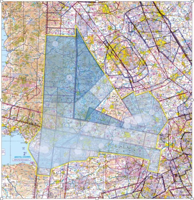
CAP 2235                                                                                                                                            Contents

     Additional Information............................................................................................................34

         Additional Information Sources ............................................................................................34

     CAA 2019 – 2020 Consultation ..............................................................................................35

         Summary of Legacy Consultation Responses Relevant to the Cotswold Area ..................35

     Report Summary .....................................................................................................................37

         Summary ..............................................................................................................................37

     Appendix A – Airprox Board Report on the Cotswold Region ..........................................38

         UKAB OBSERVATIONS ON COTSWOLD AREA AIRPROX 2019-2020 ..........................38

         BARRIERS - GENERAL ......................................................................................................40

         BARRIER PERFORMANCE COMPARISON ......................................................................41

         GENERAL ............................................................................................................................42
         COTSWOLD AREA AIRPROX:.........................................................................................43

August 2021                                                                                                                                          Page 4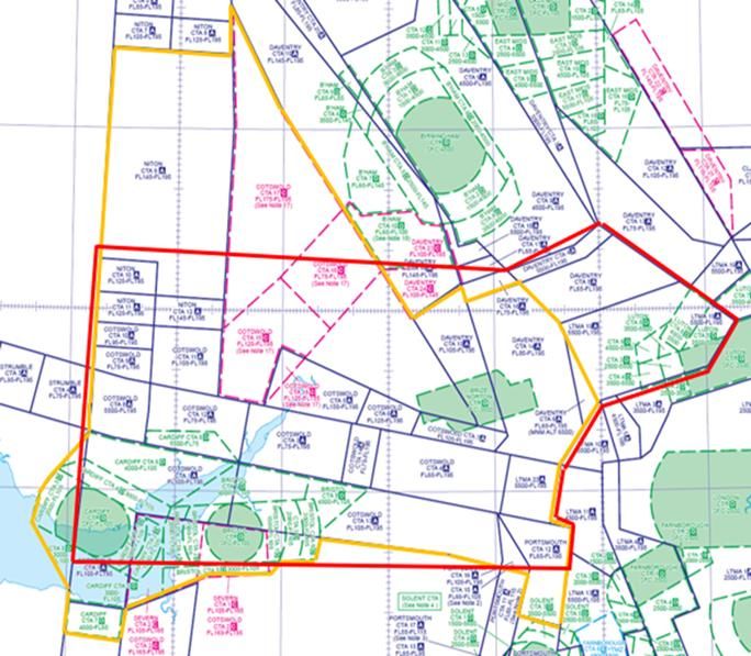
CAP 2235                                                                                              Executive Summary

     Executive Summary

     Executive Summary
     The Secretary of State has given the CAA the function to review airspace classifications in
     the UK and to amend them where appropriate. CAP 19911 explains that regulatory
     procedure. The Airspace Classification Review team was established in December 2020 to
     undertake this task.
     To successfully undertake the airspace classification review task, a joint and integrated
     approach must be adopted, and collaborative working is essential to deliver it. Intelligence
     gathering from a variety of sources, supported with evidence-based data, is central to
     understanding and capturing how the airspace is currently, and has historically, been
     utilised.
     Transparent and pro-active engagement will encourage those with an interest in a change
     in airspace classification to feel confident that their voice has a formal place in the
     procedure. Openness also allows the CAA and the airspace controlling authority (ACA) to
     see more clearly what is expected from them.
     We have adopted a regional approach to tackling this task and our first region of focus is
     the Cotswold Region. Any volumes of airspace identified as being suitable for re-
     classification will be listed and prioritised, as per the procedure detailed within CAP 1991.
     This report provides a factual overview of the intelligence gathered to date on the
     Cotswold Region. It will be used to facilitate discussions with the broad stakeholder
     representative groups representing users and air traffic service providers who are active in
     this region. The report will be discussed at a number of workshops to be held during
     September. Stakeholders will also be encouraged to complete a short survey setting out
     their experiences of operating within this region.
     All intelligence will be gathered, scrutinised and then used to develop an initial plan of
     airspace volumes to take through to the amend phase of this process. A consultation will
     be held on this initial plan and the responses to that consultation will be used to develop
     the final plan of airspace volumes to take forward to the amend phase.

     1     Procedure for the CAA to review the classification of airspace (CAP 1991), November 2020

August 2021                                                                                                     Page 5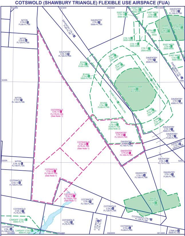
CAP 2235                                                                              Executive Summary

     Purpose of this report
     The CAA’s Procedure to review the classification of airspace (CAP 1991 - but hereafter
     referred to as the classification review procedure or process) requires the CAA to regularly
     consider whether to carry out a review of airspace classification; to carry out a review
     (including consulting airspace users) where we consider a change might be made; and to
     amend the classification as we consider appropriate. This report forms part of the review
     phase of this procedure.

     This report summarises the scope of the airspace classification review task and the
     process by which it will be achieved. It also provides an overview of our approach to
     stakeholder engagement at this stage of the process. Its main function is to detail what we
     know about airspace usage within the Cotswold Region, taking airspace composition,
     existing Airspace Change Proposals (ACPs) and safety data into account with a view to
     encouraging informed feedback from stakeholders on their experiences of operating within
     this region. Qualitative analysis of the information presented has been kept intentionally
     limited to encourage a full and open discussion of the airspace throughout the
     engagement phase.

     We have chosen to undertake our review of UK airspace on a regional basis and have
     chosen the Cotswold Region as our first area to review. To inform our intelligence base for
     this region, we are now seeking insight from users of this airspace to better understand
     how the it is currently used and any perceived issues with it. We will review the insight
     received, discuss that feedback with the relevant airspace controlling authorities within the
     region and, where necessary, use our Airspace Analyser tool to corroborate the findings.

     A survey focusing upon the Cotswold Region accompanies this report and we encourage
     participation from all stakeholders with knowledge and experience of operating within this
     airspace. We are seeking proposed volumes of airspace for detailed review, even if they
     are out of scope (see below) for us to take to the amend phase. We will consider, capture,
     and share the information gleaned from the survey responses.

     By gaining a holistic understanding of how airspace is utilised within this defined region,
     we will be able to produce an initial plan of airspace volumes where a case could be made
     for a proposed amendment to the classification. We will then consult aviation stakeholders
     on that initial plan in order to develop a final plan of airspace volumes to take forward to
     the amend phase of our process.

August 2021                                                                                         Page 6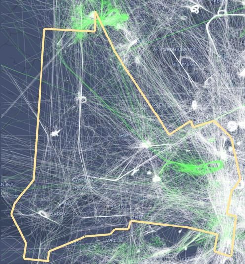
CAP 2235                                                                                               Executive Summary

     Background.
     UK airspace is some of the most complex in the world, yet its design dates back to the
     1950s and 1960s. Change sponsors, usually an airport or air navigation service provider,
     frequently present new airspace designs to the CAA for approval through the Airspace
     Change Proposal process (CAP 1616)2, however, the revised Air Navigation Directions3,
     issued in Oct 19 and effective from Dec 20, gives the CAA itself the role of designing and
     proposing amendments to airspace via the new procedure to review the classification of
     airspace (CAP 1991).
     This new procedure is a tool for delivering one of the 15 initiatives of the Airspace
     Modernisation Strategy (AMS)4 and must therefore dovetail with the other initiatives, to
     achieve the important, holistic approach to airspace modernisation.
     The Secretary of State’s covering letter5 to the revised Air Navigation Directions stated that
     they were designed to strengthen how airspace is managed. The letter also said that the
     Minister was committed to see that the UK benefits from being the best place in the world
     to undertake General Aviation-related activities, and that enhancing the UK’s existing
     airspace arrangements was key to achieving this objective.
     This report has been prepared on the basis that the reader has knowledge of both the
     CAP 1991 process as well as the associated Airspace Change Proposal process and the
     terminology contained therein.

     2     Airspace Change: Guidance on the regulatory process for changing the notified airspace design and
           planned and permanent redistribution of air traffic, and on providing airspace information CAP 1616,
           March 2021
     3     Civil Aviation Authority (Air Navigation) Directions 2017, as amended by the Civil Aviation Authority (Air
           Navigation) (Amendment) Directions 2018 and the Civil Aviation Authority (Air Navigation) (Amendment)
           Directions 2019. The 2017 Directions form an annex to the Air Navigation Guidance 2017 and the 2018
           and 2019 amendments will also be annexed in due course. For ease of reference, the CAA also produces
           a consolidated version. These can be found at
           https://www.caa.co.uk/Commercialindustry/Airspace/Airspace-change/Legislative-framework-to-airspace-
           change/
     4     Information about the Airspace Modernisation Strategy: About the strategy | UK Civil Aviation Authority
           (caa.co.uk)
     5     The CAA has published the Secretary of State’s letter of 30 October 2019. The function to regularly
           consider whether airspace classification should be reviewed, and to amend it as the CAA considers
           appropriate in accordance with a procedure, did not previously exist.

August 2021                                                                                                          Page 7
CAP 2235                                                              Filters to be applied to airspace volumes

     Filters to be applied to airspace volumes

     CAP 1991 Filters
     In drawing up our list of possible volumes for amend, we apply a series of filters to remove
     proposals that are not appropriate for this procedure. We would not normally progress a
     proposed change if:

              ▪    It would result in an adverse effect on military operations.

              ▪    It would have significant operational or environmental impact e.g. if we would
                   need to make changes to departure and arrival routes at aerodromes.

              ▪    The airspace volume was in the immediately preceding classification review.

              ▪    Airspace that is subject to a change in airspace design:

                       ▪   Where a change is between stages 1 to 4 of the CAP 1616 process,
                           or equivalent stages where subject to the CAP 725 process.

                       ▪   Where a change is between (or has recently completed) stages 5 to
                           7 of the CAP 1616 process, or again equivalent stages where subject
                           to the CAP 725 process.

     Figure 1 contains a Flow Chart to filters as per the airspace classification review
     procedure.

August 2021                                                                                            Page 8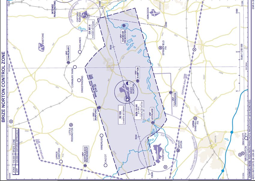
CAP 2235      Filters to be applied to airspace volumes

August 2021                                    Page 9
CAP 2235                                                            Filters to be applied to airspace volumes

     Airspace Change Proposals
     Much of the airspace within this region, and the UK more broadly, is subject to ongoing
     airspace change proposals (ACPs) in line with the CAA and DfT’s ambition to modernise
     airspace in the UK. ACPs are complex and technically detailed in nature and are
     constantly changing and evolving as they go through the CAP 1616 (or its predecessor,
     CAP 725) process.

     While the airspace classification review procedure precludes us from amending airspace
     which is currently subject to an ACP, having an overview of the purpose and scope of
     existing ACPs within the region gives us and our stakeholders a more comprehensive
     overview of airspace change activity.

     With this in mind, we are creating a standalone ACP report which will capture all ACPs in
     the Cotswold Region. The ACP report and future versions of it will contain:

              ▪   Factual descriptions of each ACP including nature, current stage, and level.

              ▪   Geographical images of ACP activity in our region.

              ▪   Time/Date stamps of each report version.

              ▪   Description of the airspace classification review procedure filters, and the
                  allowance of certain exceptions.

     In the Review Stage the Airspace Classification Review team will draw up a list of airspace
     volumes for potential classification change. The ACP report along with other relevant
     material will be used by the CAA to help filter out the airspace volumes which it cannot
     take to the Amend Stage.

     Our procedure does, however, allow for exceptions to be made to the filtering process. For
     ACPs in between Stages 1-4 of the CAP 1616 process (or equivalent stages where
     subject to the CAP 725 process), any exceptions can be made on a case-by-case basis.
     For ACPs in between stages 5-7 of the CAP 1616 process (or equivalent stages where
     subject to the CAP 725 process), any changes to airspace classification we feel would be
     sufficiently distinct from what the ACP is trying to achieve, can allow us to make an
     exception.

     Throughout our process, we will liaise with Airspace Change Sponsors and (ACAs) to
     develop our understanding of the region and the changes that are being proposed, and,
     where we have removed airspace volumes in the filtering process, any valuable
     intelligence/data we have gathered will be shared with the ACP Sponsors.

August 2021                                                                                         Page 10
Stakeholder Engagement
Stakeholder Engagement
Introduction
Productive stakeholder engagement is integral to our success with this task. This
procedure relies heavily on engagement with a broad range of stakeholders to inform our
thinking during all stages of the process, from deciding which region of UK airspace to
review, through to making any amendments to airspace classifications or air traffic
management arrangements.
The procedure also requires two formal consultations. The first, at the review phase, on
our initial plan of airspace volumes to take forward for more detailed review, and the
second, at the amend phase, to gather views on the proposed amendments to a volume of
airspace as a result of this review.
The stakeholders with whom we wish to engage are diverse. They range from large
commercial airlines to general aviation in all its forms; from large air navigation service
providers (ANSP) such as NATS and MoD, to the smaller designated airspace controlling
authorities and airfields. At the latter stages of the process, we may also want to engage
with those communities and environmental bodies which may be directly impacted by any
proposed changes to airspace classification.
Vision
The Airspace Classification Review team is committed to undertaking an open and
transparent, two-way stakeholder engagement as we carry out this review of the Cotswold
Region. Our aim is to ensure that all relevant stakeholder insight is captured, considered
and integrated into our review of, and proposals for the amendment to, UK airspace
classification.
Our vision is to ensure that we undertake the review of airspace classification in a manner
which provides equal opportunities for stakeholders to contribute to our thinking throughout
the airspace classification review process, and which demonstrates that we are
participating in effective two-way engagement.
Engagement is described in terms of ensuring that proposals are received by an informed,
engaged audience who are able to effectively feed-in their views.
August 2021 Page 11Stakeholder Engagement
Objectives
Our objectives for effective stakeholder engagement are that it is:
▪ Open, honest, and transparent – we commit to publishing all relevant
information on a targeted section of our webpage.
▪ Clear and accessible – we commit to using plain English, wherever possible
(recognising that some technical terminology will be required), to ensure that
our engagement is readily understood by our various stakeholder groups and
therefore enabling them to base their views on a reasonable understanding
of the situation.
▪ Demonstrates a willingness to be influenced – we will make clear how
and when our decisions have been informed by engagement with our
stakeholders.
▪ Proactive – we will look beyond established engagement meetings to
ensure that we are providing targeted engagement with all relevant groups at
the right points in the process.
▪ Proportionate – we will ensure that the level of engagement matches the
scale of the issue at hand. Recognising that some proposals may have a
limited impact and therefore will rightly have a different engagement
requirement to more significant changes to airspace classification.
Effective two-way engagement is a continuous process. This means that we will seek out
stakeholder views, collate and assess these views, share our findings, test the
acceptability of any resulting proposals and then, once agreed, implement the proposals in
an open, honest and transparent way.
We recognise that our stakeholders may be subjected to numerous different engagement
channels throughout the broader airspace modernisation process underway in the UK. We
understand that this can lead to confusion and to ‘engagement fatigue’. As such, we will
seek to build on existing relationships so as to minimise the number of engagement
channels our stakeholders are required to interact with. We will also seek to set up
dedicated channels where this is required by the process, for example, in order to received
detailed, local insight on a particular airspace volume.
August 2021 Page 12Stakeholder Engagement
Our Stakeholders
Our stakeholder identification process has enabled us to develop an extensive list of
stakeholders with whom we will engage throughout the airspace classification review
process. This list will be updated and adapted as we move through the process. We have
grouped these stakeholders as shown in Figure 2 below. This allows us to consider each
group’s level of interest in, and understanding of, the process, as well as considering what
information we might require from each group to inform our thinking on the approach to
each region of airspace.
The groups are broad and will contain sub-groups with differing levels of interest in a
particular subject. They comprise:
▪ Designated Airspace Control Authorities (ACAs) of the specific airspace
volumes under review and, as a subset, NATS and MoD
▪ Airspace users
▪ General Aviation
▪ Commercial airlines
▪ Communities – includes those affected by aviation noise or other
environmental impacts, as well as their representatives, such as Local
Authorities, Councils or other representative groups as defined by a
calculated overflight metric.
▪ Government / Regulatory - includes both national Government
departments, in particular the Department for Transport, as well as other
bodies who have significant political or regulatory influence.
Our stakeholder mapping process has identified many different commercial and non-
commercial users of this airspace, air navigation service providers, airports and airfields
operating within the region. Due to the numerous stakeholders operating in the region,
their diverse nature, the limited resources available to the team, and in keeping with the
requirements of our airspace classification review procedure, we have decided to adopt a
proportionate approach to our engagement activity and, at the first instance, to engage
directly with the Stakeholder Representative Groups representing the users of this
airspace.
August 2021 Page 13Stakeholder Engagement
Figure 2: Our Stakeholder Representation Groups
National Stakeholder Representative Groups Larger ANSPs / ACAs
Air Pilots and the Royal Institute of British Rotorcraft Association MOD
Navigation
Airspace4All British Skydiving NERL
Airport Operators Association Commercial Ballooning Association NSL
AOPA Drone Major Group Brize
APPG-GA Drone Safe Register Bristol Airport
ARPAS Flying Farmers Benson
Airlines UK General Aviation Awareness Council Cardiff Airport
British Air Display Association General Aviation Safety Council London Oxford Airport
BALPA Guild of Air Traffic Control Officers Airport Consultative Committees
British Balloon and Airship Club Helicopter Club of Great Britain
British Business and General Aviation International Air Transport
Association Association
General and Business Aviation Large Model Association
Strategic Forum
British Gliding Association Light Aircraft Association
British Hang Gliding and Paragliding Met Office
Association
British Helicopter Association PPL-IR
British Microlight Aircraft Association Volocopter
British Model Flying Association
We appreciate that we may have not yet included all relevant stakeholder representative
groups in Figure 2. We will continue to add to the table as new stakeholder groups are
identified and welcome further suggestions if there are any groups we have overlooked.
We will work closely with these strategic representative bodies and request that they act
as conduits for our two-way engagement, reaching out to their members and collating the
localised knowledge that will be central to our understanding of what issues there may be
in the Cotswold Region and what potential solutions might be available to alleviate these.
We will also be seeking insight as to what current local arrangements, such as Letters of
Agreement, are working well or could be improved.
August 2021 Page 14Stakeholder Engagement
Our Approach to Engagement in the Cotswold Region
We are holding a series of workshops with interested stakeholders to discuss their, and
their members’ experiences of operating within the Cotswold Region. Ahead of each
workshop we will circulate this report to allow stakeholder representatives to disseminate
amongst their members and collate their views.
Stakeholders will be invited to participate in workshops where we will present our initial
findings into the region and request feedback and real experiences from the audience.
Following each engagement session, stakeholders will be asked to complete an online
survey. This will give them the opportunity to provide their views on any airspace volumes
which they believe should be considered for amendment under this process, as well as the
potential solutions they would wish to see.
In addition, the presentation slides from the workshops and this report will be made
available on our webpage to allow people to review and provide responses to their survey
in their own time. The survey will remain open for completion until 30 September 2021.
We will collate the views heard from the engagement sessions and the online survey
responses and share these with the relevant ACAs operating in the region to get their
views and response to the comments made. We will use these conversations to help us
understand whether there is an issue relating to airspace within the region and the extent
to which airspace classification is a causal factor to the perceived issues. It is likely that
this exercise will require subsequent follow up meetings to help us further understand the
views that we have heard.
Next Steps
We will collate views from our stakeholders, discuss with relevant ACAs and corroborate
them, where feasible, with insight from our Airspace Analyser tool. This tool has been
developed in conjunction with Plane Finder and EMU Analytics and provides us with a
visual representation of airspace usage, with historic data back to 2018. It allows us to
interrogate UK airspace through a variety of filters based upon aircraft type, altitude,
destination etc. When aircraft movements are viewed in conjunction with manipulation of
the airspace altitude and classification filters, the tool allows us to analyse airspace usage
in a highly credible way. It has also been overlaid with Airprox and infringement
information, further enabling us to build our understanding and add to our analysis.
This information will be used to create our initial plan of airspace volumes, where a case
could be made for a proposed amendment to the classification. We aim to consult on this
plan towards the latter end of the year. In the initial plan we will set out the messages we
heard during our engagement exercise and how we have used this insight to inform our
view of potential airspace volumes to take through to the amend phase of the airspace
classification review process.
We will ask consultees whether they agree with the volumes and the supporting rationale,
or whether there are any that should be added, removed or adjusted. The responses to
this consultation will inform our final plan of airspace volumes which we will take forward to
the amend phase of the process.
August 2021 Page 15COTSWOLD REPORT V2.0 Cotswold Region – What We Know
Cotswold Region – What We Know
Airspace Delineation
The volume of airspace referred to within this report is based upon the boundaries
delineated by the Cotswold Altimeter Setting Region (ASR), (also referred to as “the
Cotswold Region”), with some slight amendments.
The red line in Figure 3 details the ASR as per the AIP (ENR 6-1-7-1), the yellow line
reflects the altered boundary for the airspace being reviewed within this report and will be
referenced throughout as the Cotswold Region.
Alterations to the published ASR boundary were required in order to apply logic and align
with airspace boundaries:
▪ Extended north in to the Shawbury Triangle to incorporate the COTSWOLD
CTA 15, CTA 16, CTA 17 & CTA 18.
▪ Eastern edge reduced. Includes Daventry CTA 6 and omits Luton airspace.
▪ Southern edge slightly extended to incorporate Cardiff CTA 7 and Bristol
CTA 5.
▪ Extended to south east to include Portsmouth CTA 12.
Figure 3: Cotswold ASR (red line) vs altered boundary (yellow line)
August 2021 Page 16COTSWOLD REPORT V2.0 Cotswold Region – What We Know
Regional Summary
This region is composed of a mix of regional and local airports, numerous minor
aerodromes, and glider sites. Several flying training organisations operate within the
airspace and there are multiple para-dropping sites. Cardiff and Bristol airports are in the
south west of the region, Gloucester Airport is in the middle and London Oxford Airport is
in the north east.
It also contains RAF Brize Norton, the RAF’s largest aerodrome, operating a range of
multi-engine transport and air-to-air refuelling aircraft. Whilst RAF Benson and RAF
Shawbury are out of the area boundary, their ATZ and / or MATZ does impinge and much
of their rotary operations are conducted within this airspace.
The Oxford Area of Intense Aerial Activity (AIAA) is sited in the east of the region and the
Shawbury AIAA is in the north. It is a busy area for General Aviation and glider activity is
particularly prevalent. Airspace restrictions include several Danger Areas and Restricted
Areas, Gas Venting Sites, High Intensity Radio Transmission Areas (HIRTAs) and a Bird
Sanctuary.
The region contains several AONBs: the Shropshire Hills in the north, the Wye Valley and
Malvern Hills in the centre of the region and the UK's largest- the Cotswolds AONB, in the
south. Along the western of the Cotswolds AONB's is the Cotswold Edge, an 84-kilometre
escarpment that rises to elevations of 300m.
August 2021 Page 17COTSWOLD REPORT V2.0 Cotswold Region – What We Know
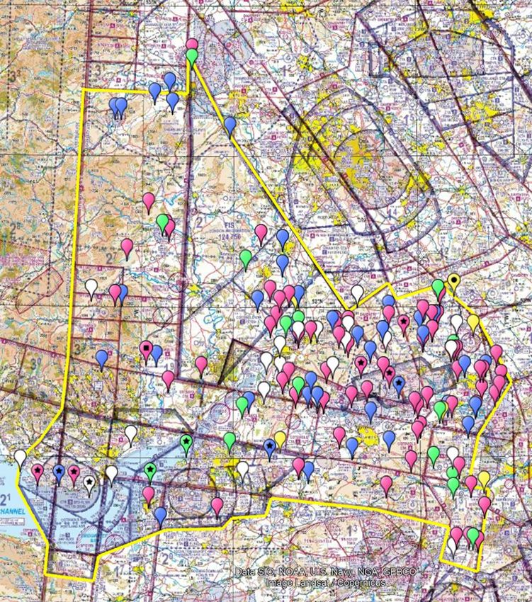
Airspace Composition
The airspace being reviewed, as depicted by the yellow line on Figure 4, makes up a
relatively small proportion of the UK FIR. Due to the complexity of the airspace, along with
multiple ACAs and the many different airspace users, it is both congested and contested.
Figure 4: Cotswold boundary (yellow line) – taken from the CAA’s Airspace Analyser Tool.
NOT NOT
FOR FOR
NAVIGATIONAL
NAVIGATIONAL
USE USE
August 2021 Page 18COTSWOLD REPORT V2.0 Cotswold Region – What We Know
Bristol/ Cardiff / Cotswold / Severn Control Zones and Control Area
Figure 5 shows the complex airspace to the south west of the region and the numerous
and frequent changes to base levels.
Figure 5: UK AIP Chart (ENR 6-41) Reproduced with permission from the CAA and NATS
NOT FOR NAVIGATIONAL USE
August 2021 Page 19COTSWOLD REPORT V2.0 Cotswold Region – What We Know
Brize Norton Control Zone (CTR)
Figure 6 shows the RAF Brize Norton CTR, which is active H24 and extends Surface to
3500ft. The station operates different types of multi-engine transport aircraft, much of
which join or exit Controlled Airspace (CAS), without direct connectivity with the national
airways structure.
Figure 6: UK AIP Chart (ENR 6-39) Reproduced with permission from the CAA and NATS
NOT FOR NAVIGATIONAL USE
August 2021 Page 20COTSWOLD REPORT V2.0 Cotswold Region – What We Know
Flexible Use Airspace - COTSWOLD CTA 15, CTA 16, CTA 17 & CTA 18
The Flexible Use Airspace, as shown in Figure 7, becomes Class C between hours 1700-
0900 (1600-0800) Monday-Thursday and 1700 (1600) Friday (or the day preceding a PH)
to 0900 (0800) Monday (or the day following a PH). Outside the published hours of
service, the airspace reverts to Class G.
Figure 7: UK AIP Chart (ENR 6-82) Reproduced with permission from the CAA and NATS
NOT FOR NAVIGATIONAL USE
August 2021 Page 21COTSWOLD REPORT V2.0 Cotswold Region – What We Know
Airspace Restrictions and Hazardous Areas
The restricted airspace and hazardous areas are listed below and depicted in Figure 8.
The Airspace Classification Review Team is working alongside Airspace Regulation to
review Danger Area and Restricted Area usage and to assess whether the existing
associated airspace is fit for purpose.
Figure 8: Cotswold boundary (yellow line) overlayed on UK AIP Chart (ENR 6-75)
Reproduced with permission from the CAA and NATS
NOT FOR NAVIGATIONAL USE
August 2021 Page 22COTSWOLD REPORT V2.0 Cotswold Region – What We Know
Danger/Restricted Areas:
▪ Danger Area EG D119 – Bridgwater Bay – SFC–5000FT
▪ Restricted Area EG R153 – Hinkley Point – SFC-2000FT
▪ Danger Area EG D147 – Pontrilas – SFC–10000FT
▪ Danger Area EG D216 – Credenhill – SFC–2300FT (Occasionally notified up
to 10000FT)
▪ Restricted Area EG R154 – Oldbury – SFC–2000FT
▪ Restricted Area EG R155 – Berkeley – SFC–2000FT
▪ Restricted Area EG R105 – Highgrove House – SFC–2000FT
▪ Danger Area EG D129 – Weston-On-The-Green – SFC–FL120
▪ Restricted Area EG R101 – Aldermaston – SFC–2400FT
Gas Sites:
▪ Avonmouth Gas Venting Site – SFC-3500FT
▪ Wormington Gas Venting Site – SFC-2600FT
Small Arms Ranges – possible hazard to aircraft at or below 500ft:
▪ Yoxter Small Arms
▪ Rogiet Moor Small Arms
▪ Ross on Wye Small Arms
▪ Radnor Small Arms
▪ Tyddesley Wood Small Arms
▪ Otmoor Small Arms
▪ Moody’s Down Small Arms
HIRTA’s (Hight Intensity Radio Transmission Areas):
▪ Woofferton – SFC-1600FT
▪ Pershore – SFC-14300FT
▪ Colerne – SFC-3700FT
August 2021 Page 23COTSWOLD REPORT V2.0 Cotswold Region – What We Know
▪ Barford St. John – SFC-600FT
▪ Madley – SFC-6800FT
Laser Site:
▪ QinetiQ Pershore – SFC–UNL
Bird Sanctuaries:
▪ Severn – Mid September to early April – SFC-4000FT
▪ Otmoor – Permanent – SFC-2000FT
August 2021 Page 24COTSWOLD REPORT V2.0 Cotswold Region Safety Report
Cotswold Region Safety Report
Introduction
Aviation safety is the CAA’s number one priority and, as such, certain occurrences,
incidents and accidents are reported. This information can be used to help build a
picture of how an area of airspace operates and why.
Airprox and airspace infringements reports are of particular interest in relation to
airspace safety and airspace usage as either of these events could ultimately result in
lead to a mid-air collision. The composition and design of airspace and how it is
represented will have an influence on the likelihood of events such as these occurring.
Other influencing factors include, but are not limited to, the amount of traffic that uses a
particular section of airspace, weather, personnel training, experience and recency.
Although there may be reference to these other factors they lie mostly beyond the
scope of this report.
Airspace Infringements
An airspace infringement is “the unauthorised entry into notified airspace by an aircraft”
where notified airspace is either controlled airspace, prohibited or restricted airspace
(permanent and temporary), active Danger Areas (permanent and temporary),
aerodrome traffic zones, radio mandatory zones, transponder mandatory zones or a
combination of these.
The airspace within the Cotswold area is detailed in the “What we know” section of this
document. The composition, structure and mix of controlled and Class G airspace,
creates an environment where aircraft can move freely around the edges of notified
airspace. This could create a situation where, should an aircraft inadvertently enter
notified airspace without the necessary permission or clearance, an airspace
infringement could occur.
In Figure 9 we can see the number of reported airspace infringements that occurred
into notified airspace within our region from 2015 onwards.
Airspace infringements across the UK reduced from 66 occurrences to 47 in from 2018
to 2019, whilst the number of flights that occurred in each year was comparable.
As a result of the Covid-19 pandemic, 2020 flights were reduced by circa 28% and, as
expected we have seen a slight reduction in the number of infringements. If we apply a
28% correction factor to the number of infringements, we can see how 2020
infringements might have compared with the norm.
August 2021 Page 25COTSWOLD REPORT V2.0 Cotswold Region Safety Report
Figure 9: Airspace Infringements Graph, N.b. 2021 figures up to May.
There was a change in the recording mechanism for airspace infringements from
January 2020 onwards giving pin-point location for each infringement rather than, as
had been done previously, just generic airspace blocks. These infringements have
been plotted in Figure 10.
For those that appear on the boundary of our region, some of the infringements will
have occurred in airspace that is just outside our region, however, as the traffic that
caused the infringement will have originated from within it, these infringements are of
interest to us.
Eight of the reported airspace infringements that occurred on the boundary of this
region during the period of January 2020 to May 2021 (inc), involved airspace outside
of the region. In all of these cases the aircraft originated from within the Cotswold area
and as such give us cause to look at traffic patterns in that vicinity.
August 2021 Page 26COTSWOLD REPORT V2.0 Cotswold Region Safety Report
Figure 10: Airspace Infringements from Jan 20 to May 21
NOT FOR NAVIGATIONAL USE
The Airspace Classification Review team are deeply involved in CAA and airspace user
group initiatives to reduce airspace infringements. Airspace infringements often result
in the degradation of safety barriers which could then lead to a loss of separation
between aircraft, Airprox or Mid-Air Collision.
The team has representation on the Airspace Infringement Working Group (AIWG)
(including their airspace infringement causal factor analysis), Infringement Coordination
Group (ICG) and Local Airspace Infringement Teams (LAITs).
This involvement allows for two-way flow of information and ideas that can be
employed to reduce and prevent airspace infringements. An important part of the work
that is done by the team when looking at airspace is to consider what actions can be
taken and what recommendations can be made to reduce the number of airspace
infringements. This cross-department collaboration contributes greatly to the
classification review work and will assist us in effecting positive change to airspace.
August 2021 Page 27COTSWOLD REPORT V2.0 Cotswold Region Safety Report
Airprox
An Airprox is “a situation in which, in the opinion of a pilot or a controller, the distance
between aircraft, as well as their relative positions and speed, was such that the safety
of the aircraft involved was, or may have been, compromised.”
Each Airprox is evaluated by the UK Airprox Board (UKAB) and assigned a risk of
collision category based on the table and definitions below.
Risk of collision level assessments are made based on what took place and not on
what may or may not have happened. There are four categories, A - D agreed at
international level, and one UK category, E, as follows:
A Risk of collision: aircraft proximity in which serious risk of collision has existed.
B Safety not assured: aircraft proximity in which the safety of the aircraft may have
been compromised.
C No risk of collision: aircraft proximity in which no risk of collision has existed, or
risk was averted.
D Risk not determined: aircraft proximity in which insufficient information was
available to determine the risk involved, or inconclusive or conflicting evidence
precluded such determination.
E Met the criteria for reporting but, by analysis, it was determined that normal
procedures, safety standards and parameters pertained.
Whilst Airprox prevention is ultimately the responsibility of the pilot, ANSP’s have the
ability to aid prevention by providing information or instructions and so, when pilots are
in receipt of a service from an ANSP, the likelihood of an Airprox event is reduced.
Figures 11 and 12 show Airprox within the Cotswold area. As with the whole of the UK,
there are fewer Airprox in this area than there are airspace infringements. As a result of
the numbers being lower, the statistics are more difficult to interpret as a single
additional event will have a disproportionate effect on the results.
However, whilst there was a steady increase in UK Airprox events during the period
between 2015 to 2019, the Cotswold Airprox figures are more volatile.
Airprox occurrences do not necessarily vary in a linear fashion with aircraft movements
and so caution needs to be exercised when correcting figures for 2020. As a result, no
correction factors have been applied to the figures for Airprox.
August 2021 Page 28COTSWOLD REPORT V2.0 Cotswold Region Safety Report
Figure 11: Airprox in the Cotswold Region, N.b 2021 figures for finalised reports up to May .
Airprox in UK vs. in Cotswold region
350 319 328
300 272
265
250
217
No. of Airprox
200
163
150
100
29 40 31 33 29
50 21 14 6
0
2015 2016 2017 2018 2019 2020 2021
UK Airprox Cotswold Airprox
The composition of airspace, the way in which it is used and how traffic navigates in
and around it can have an influence on the number and location of Airprox events.
Airprox can happen both inside and outside of notified airspace, and, by their nature,
more often occur where traffic density is higher.
The information presented here is for the total number of reported Airprox from risk
category A-E within our region. It is worth remembering that risk of collision category E,
is where although a report was made by analysis, it was determined that normal
procedures, safety standards and parameters pertained, and risk category D reports
where the risk of collision is not determined: this normally occurs where insufficient
information was available or where the individual reports offered inconclusive or vastly
conflicting information which precluded an objective.
August 2021 Page 29COTSWOLD REPORT V2.0 Cotswold Region Safety Report
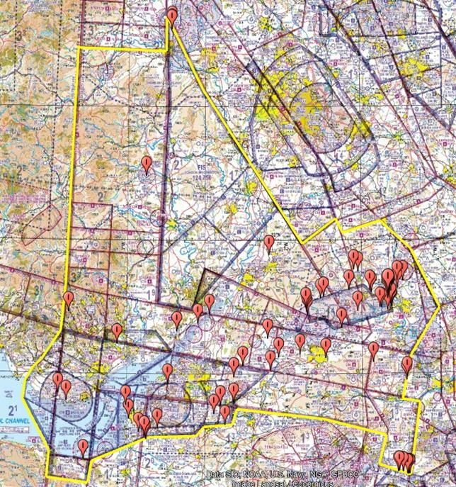
Figure 12: Airprox in the Cotswold Region
NOT FOR NAVIGATIONAL USE
*2020 data up to and including October.
Comparing the two graphics in Figure 13 below, it can be seen that there is a
correlation between the locations of Airprox events within the Cotswold area and the
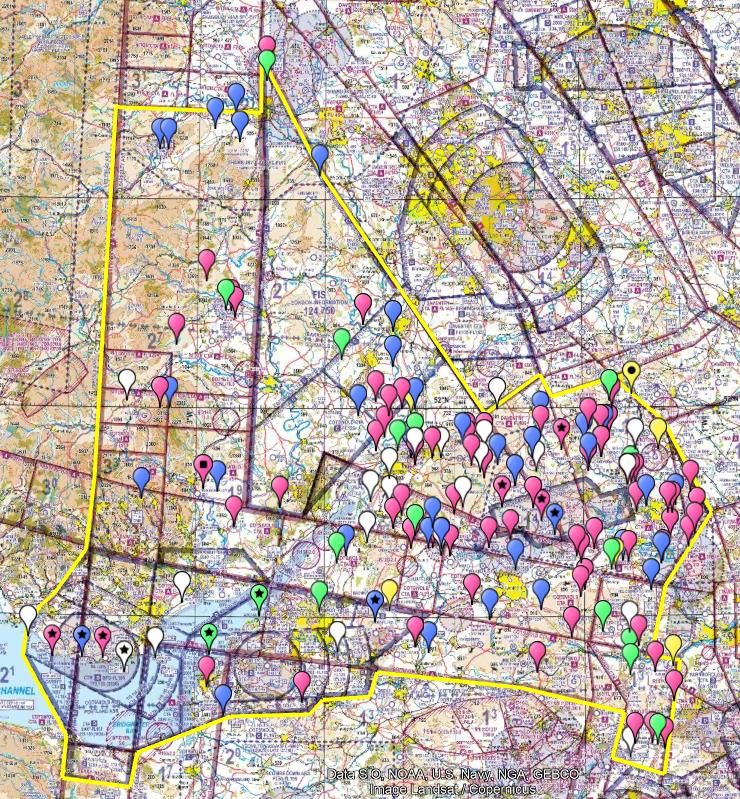
density of the aircraft tracks displayed. Tracks are sample of non-commercial aircraft
tracks below 10,000’ for 3 months at the start of 2020.
August 2021 Page 30COTSWOLD REPORT V2.0 Cotswold Region Safety Report
Figure 13:
Track sample flights up to 10,000’ Cotswold Airprox events 2015-2020
An Airprox is only one step away from a mid-air collision and as such they are taken
seriously. The CAA, along with the UK Airprox Board and other bodies work together to
assess the level of risk that exists and mitigate where possible. In a similar way to
airspace infringements, the reduction and mitigation of the risk of Airprox, and hence
Mid-Air collision, are an important consideration of the Airspace Classification Review
team and as such we have representation at the Mid-Air Collision Challenge Group
(MAC-CG).
As part of our collaborative work, UKAB have analysed all risk category A, B and C
events for 2019 and 2020. Extracts of that report are shown in Figures 14 and 15. They
illustrate which airspace user group are most regularly involved in Airprox both within
our region and on a national scale. The full UKAB report is attached in Appendix A.
August 2021 Page 31COTSWOLD REPORT V2.0 Cotswold Region Safety Report
Figure 14: 2019-2020 Overall Figures
2019-2020 OVERALL
FIGURES
86% of AIRCRAFT TO
AIRCRAFT Airprox involve GA
(Sports/rec – including
Unknown/UNTRACED)
93% of RISK BEARING
AIRCRAFT TO AIRCRAFT
Airprox involve GA (Sports/rec
– including
Unknown/UNTRACED)
Figure 15: 2019-2020 Cotswold Area
2019-2020 Cotswold area:
93% of AIRCRAFT TO
AIRCRAFT Airprox involve
GA (Sports/rec – including
Unknown/UNTRACED)
94% of RISK BEARING
AIRCRAFT TO AIRCRAFT
Airprox involve GA
(Sports/rec – including
Unknown/UNTRACED)
August 2021 Page 32COTSWOLD REPORT V2.0 Cotswold Region Safety Report
Mid-air Collision
The consequences of a mid-air collision between aircraft are severe and could also
impact on persons on the ground in the vicinity of such an event.
Although rare, it should be remembered that an Airprox or an airspace infringement
could result in such an event.
There has been one reported mid-air collision in the Cotswold area since 2015 between
a model glider and a light aircraft in which the model crashed and the aircraft sustained
minor damage and landed safely. This event was not over a built-up area and minimal
effect was felt on the ground.
August 2021 Page 33COTSWOLD REPORT V2.0 Additional Information
Additional Information
Additional Information Sources
For our review of the airspace usage within this region to be sound, we rely on airspace
users reporting their experiences. This will aid us in identifying opportunities for
improving equitable access. The CAA provides a number of platforms for pilots and
airspace users to submit information relating to use and access.
Form FCS1521 was available for voluntary reporting of airspace issues including, but
not limited to noise issues, aerial activity and refusal of air traffic service and denied
access to airspace. From 2021 the capture of events relating to refusal of air traffic
service and denial of access to airspace was separated from form FCS1521 (which
remains and should be used for other airspace related reports) and a new form,
FCS1522, was created specifically to capture this information.
Across these two platforms there have been 4 reports made, relating to either refusal of
service or denial of access within our region, all relating to airspace that is associated
with Bristol.
We have also extracted the legacy consultation responses relevant to the Cotswold
region and will use them to shape our discussions with the relevant ACAs and to inform
our review.
August 2021 Page 34CAP 2235 CAA 2019-2020 Consultation
CAA 2019 – 2020 Consultation
Summary of Legacy Consultation Responses Relevant to the
Cotswold Area
A CAA consultation ran from December 2019 to March 2020, seeking potential
volumes of airspace where the classification could be amended to better reflect the
needs of all airspace users and on an equitable basis.
The comments received referencing airspace within the region will be incorporated into
the Cotswold Region review and can be summarised as follows:
▪ Controlled Airspace Base Levels: Many responses stated that lower
levels of CAS were underutilised and negatively impacted GA, with a
significant number of comments relating to the impact upon gliding
activity. This complaint was made about almost all CTAs within the
region.
▪ Traffic Levels: Responses questioned whether traffic volumes at the
larger aerodromes within this region warranted the volume of CAS around
them.
▪ Flexible Use of Airspace: Numerous respondents suggested FUA might
resolve many of the perceived issues. With various CTAs, CTRs, ATZs
put forward as suitable volumes of airspace where it would be beneficial
to change the airspace classification / activation outside of peak traffic
times.
▪ Oxford Area Intense Aerial Activity: Multiple responses expressed
concern regarding funnelling of traffic in this area due to the large volume
of the Brize Norton CTR and its proximity to Oxford Kidlington ATZ and
para dropping zones. An increased risk of airprox and / or MAC was cited
in several of these comments. Concerns regarding the safety surrounding
large military transport aircraft leaving CAS inbound to Brize and ‘mixing
with GA’ were also raised. Operating within this AIAA was reported as
being particularly challenging for gliders not equipped for RT
communication.
▪ Danger Areas and Para-dropping Sites: Many comments questioned
the requirement for various danger areas and para dropping sites to be
active H24 and suggested that activation by NOTAM would be more
appropriate. More than 20 responses expressed concern regarding South
Cerney.
▪ Restricted Areas: Some responses asked why EG R154 Oldbury and
EG R155 Berkeley still have associated restricted airspace when the
power stations have been decommissioned for some time.
August 2021 Page 35CAP 2235 CAA 2019-2020 Consultation
▪ Other: Some comments highlighted ongoing concerns with high controller
workload at aerodromes resulting in an inability to obtain a crossing
clearance.
▪ Several comments referenced the existing LoA relating to the RILES
Gliding Area, stating its successful operation and integration and
suggesting that the areas included be extended to include more airspace
to enable glider pilots operating out of Talgarth and Shobdon to be in a
position to achieve their Gold Badge.
▪ MATZ hours of operation were also questioned.
August 2021 Page 36CAP 2235 Report Summary
Report Summary
Summary
The airspace within the Cotswold Region is both congested and contested. It is a busy
area for General Aviation and glider activity is particularly prevalent. With complex
controlled airspace around the main airports, significant military flying activity, two AIAA
and the proximity to the London TMA; it is a challenging environment to operate within
and there are records of a significant number of Airprox and Airspace Infringements.
By working with other CAA departments, including Airspace Regulation, Policy, the GA
Unit, Future Airspace, ATS Inspectors and more, and having representation from our
team at numerous air safety focused meetings such as the MAC Challenge Group, the
AIWG and LAIT, we are striving to gain as comprehensive an understanding of
airspace use - historic, current and future – as possible.
We are also working with the Airprox Board and talking with ACAs, ANSPs and other
stakeholder representative groups. This collaborative approach will be essential to
enabling the Airspace Classification Review Team to effect positive change and we
encourage all with an interest in a change in airspace classification, to complete the
survey that accompanies this report and to feel confident that their voice has a formal
place in this procedure.
We are still at the information gathering stage, and we strongly encourage stakeholders
to input to this exercise by contributing to our workshops and filling out the survey. In
particular, we are asking the stakeholder representation groups to act as a conduit to
their members to assist us in gathering information from those who have direct
experience of operating in this airspace.
Once we have analysed responses and captured and documented our conversations
with internal and external stakeholders, we will publicise our initial plan of airspace
volumes for consultation. The responses to this consultation will inform our final plan of
airspace volumes which we will take forward to the Amend phase of the process.
August 2021 Page 37CAP 2235 Appendix A – Airprox Board Report on the Cotswold Region
Appendix A – Airprox Board Report on the Cotswold
Region
UKAB OBSERVATIONS ON COTSWOLD AREA AIRPROX 2019-
2020
2019-2020 OVERALL FIGURES
86% of AIRCRAFT TO AIRCRAFT Airprox involve GA(Sports/rec – including
Unknown/UNTRACED)
93% of RISK BEARING AIRCRAFT TO AIRCRAFT Airprox involve GA(Sports/rec –
including Unknown/UNTRACED)
August 2021 Page 38CAP 2235 Appendix A – Airprox Board Report on the Cotswold Region
2019-2020 Cotswold area:
93% of AIRCRAFT TO AIRCRAFT Airprox involve GA(Sports/rec – including
Unknown/UNTRACED)
94% of RISK BEARING AIRCRAFT TO AIRCRAFT Airprox involve GA(Sports/rec –
including Unknown/UNTRACED)
August 2021 Page 39CAP 2235 Appendix A – Airprox Board Report on the Cotswold Region
BARRIERS - GENERAL
All Barriers are interlinked, and a major observation on the dependencies is that the
Flight Elements Situational awareness barrier is at its core.
In general terms: Ground Elements Situational Awareness, feeds Flight Elements
Situational Awareness. Flight Elements Electronic Warning System barrier
performance feeds Ground and Flight Elements Situational Awareness and the See
and Avoid barrier, Additionally the Flight Elements Situational Awareness and the
Tactical Planning barrier feeds the See and Avoid barrier.
In essence the more information that is available on other air users in the vicinity,
assuming that the information is correctly assimilated, then the pilots are positioned in
the best way to focus their lookout and avoid other traffic.
In those cases where the Flight Elements Situational Awareness barrier is ineffective,
the Ground Elements have NOT played a part in the Airprox, or have not been able to
resolve a conflict. In all bar one of these cases, the Flight Elements Electronic Warning
Systems have been ineffective or not present and the Airprox has precipitated in an
‘non-sighting or effective non-sighting’ or a ‘late sighting’.
August 2021 Page 40CAP 2235 Appendix A – Airprox Board Report on the Cotswold Region
BARRIER PERFORMANCE COMPARISON
ALL AIRCRAFT TO AIRCRAFT_2019-2020 ALL COTSWOLD AIRCRAFT TO
AIRCRAFT_2019-2020
August 2021 Page 41CAP 2235 Appendix A – Airprox Board Report on the Cotswold Region
There are only Minor changes in the Barrier Performance of the 5 weakest Barriers,
however there are a few points to raise in the Ground Elements Situational Awareness
barrier.
Ground Elements Situational Awareness shows several differences. Overall, it is ineffective
21% of the time and in the Cotswold area it is ineffective 30% of the time.
GENERAL
Most pilots choose to take Basic
Service, this means that the controller
is not required to monitor the flight and
normally automatically leads to a
degraded situational Awareness as
the Barrier is not used. The
Contributory Factors for all Aircraft to
Aircraft support this. The Barrier is Not
Used 26% of the time.
Even if the pilots are receiving a Basic
Service, the barrier can be employed
– this is because the ASNP is actually
engaging with the pilots at or around
the
time of the Airprox, however, in these circumstances, the ability of the of Traffic Controller
to recognise and resolve a conflict can still be compromised if the other aircraft is not fitted
with and using a transponder, and/or not communicating with them.
When the barrier is employed and is deemed to perform sub-optimally, the Contributory
Factors demonstrate poor passage of information or non-detection of the conflict situation
in that order.
August 2021 Page 42CAP 2235 Appendix A – Airprox Board Report on the Cotswold Region
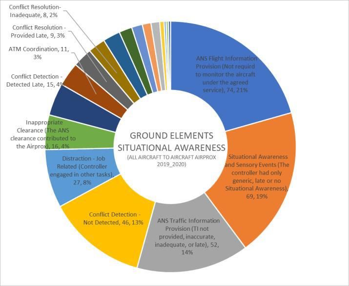
COTSWOLD AREA
AIRPROX:
There is a change in the contributory
factor distribution for Airprox in the
Cotswold Area. As stated above
‘Traffic information being late or
adequate or not provided’ and ‘Conflict
not detected’ normally sit in this order
behind Situational Awareness and
Sensory Events.
The chart for the Cotswold Area
Airprox shows a switch in the
associated contributory factors where
the conflict is not detected more
frequently that sub- optimal passage
of timely information.
I cannot say if this is actually significant as the numbers are low (only Barrier and
Contributory factors collection in a way which supports analysis only reaches back to
2019) however, it does bring out a general point which is surrounding the use of ATC
services: There is significant scope for pilots to request a service which will offer
them protection
My position from the UKAB – echoing the very strong view of the Board, is that any pilot
should request the highest level service available. This is something which is continually
included in feedback reports to individuals and something which I endeavour to press
home at all the safety meetings and engagement opportunities that I have. However, this
need to be balanced with the ability and capacity of ANSPs to service an increase
in demands for Traffic Services and Deconfliction Services and is something that
warrants a review.
Values
ANS Fl ight Information Provision (Not requird to monitor the aircraft under the agreed service) 12
Conflict Detection - Not Detected 12
ANS Traffic Information Provision (TI not provided, inaccurate, inadequate, or late) 10
Situational Awareness and Sensory Events (The controller had only generic, late or no Situational Awareness) 7
Inappropriate Clearance (The ANS clearance contributed to the Airprox) 5
Distraction - Job Related (Controller engaged in other tasks) 4
Conflict Detection - Detected Late 3
Conflict Resolution – Not provided 2
Conflict Resolution- Inadequate 2
ATM Coordination 2
Conflict Resolution - Provided Late 1
Separation Provision (The ANS instructions contributed to the Airprox) 1
Monitoring of Equipment/Instruments (Equipment misinterpreted) 1
Loss of Separation (Standard separation was not achieved) 1
Other Barriers show no significant difference in their performance.
August 2021 Page 43You can also read