Automated surface marine observations from European data buoys - Zenodo
←
→
Page content transcription
If your browser does not render page correctly, please read the page content below
P3_17 Automated surface marine observations from European data buoys   DOI: 10.5281/zenodo.934373    Poli et al.

                   Automated surface marine observations
                        from European data buoys
                     Paul Poli (EUMETNET and Météo-France, paul.poli@shom.fr),
              María Isabel Ruiz Gil de la Serna (Puertos del Estado, maribel@puertos.es),
         Kai Herklotz (Bundesamt für Seeschifffahrt und Hydrographie, kai.herklotz@bsh.de),
              Gilbert Emzivat (EUMETNET and Météo-France, gilbert.emzivat@meteo.fr),
                   Henry Kleta (Deutscher WetterDienst, henry.kleta@dwd.de), and
        Jean-baptiste Cohuet (EUMETNET and Météo-France, jean-baptiste.cohuet@meteo.fr)

Abstract
Since the mid-20th century, a growing number of automated weather buoys have been deployed for
the purpose of providing a continuous monitoring of weather conditions at the marine surface.
Thanks to advances in global telecommunications by satellite in the 1970s, these platforms have
spread to cover remote regions, while delivering data in near-real-time. Today oceanographic and
meteorological buoys are found in coastal regions, in the high oceans, and in challenging polar
regions or even on sea-ice. The data are typically collected within minutes. This paper will present
the achievements of the data buoys within E-SURFMAR, the surface marine operational service of the
observation programme of EUMETNET (a grouping of European National Meteorological Services).
Two types of buoys will be discussed: moored buoys and drifting buoys. The former provide fixed-
point time-series and multivariate information. Several variables are collected, from the lower
atmosphere (air pressure, air temperature, air humidity, wind, radiation, precipitation…) to the
deeper ocean. The latter type of buoys follow trajectories at the mercy of the ocean currents, and
report generally fewer variables, such as ocean surface current, sea-surface temperature, and
atmospheric pressure. The relative merits, limits, and applications of both types of systems will be
reviewed, along with their sustainability. Ongoing developments will also be discussed, along with
challenges ahead.

    1. Introduction
The first weather buoys collecting measurements at sea were probably deployed around the times of
World War II. One finds reports in German U-Boot log books of deploying such equipment in the
North Atlantic [1]. It is not sure what parameters were collected by these buoys, but the
meteorological information was indeed crucial for the planning and the conduct of war operations on
all sides of the conflict.

Autonomous weather buoys were hence born out of necessity, to answer a crucial question: what is
the weather like at any given time, at a remote marine location?

Proceedings for ICAWS 2017                        22/09/2017                                        Page 1/8
P3_17 Automated surface marine observations from European data buoys   DOI: 10.5281/zenodo.934373    Poli et al.

Today’s buoys are still built under the same specifications. They have to withstand difficult
conditions, deliver the data as expected, and not break down in between the maintenance schedule,
as access is extremely difficult and costly.

A key turning point was in the 1970s with the development of systems for reliable and distant data
transmission, as well as positioning. One system was initially developed coupling both capabilities,
called RAMS [2]: the initial report of this mission indicates various applications, including not only
buoys but also long-range stratospheric balloons. This first mission was followed by the Argos Data
Collection and Location System on polar-orbiting meteorological satellites, which has provided
services for nearly 30 years now [3].

Since these pioneering trials, there have been tremendous developments in the miniaturization of
electronics and the reliability of radio transmission systems and atomic clocks. This has enabled the
Global Positioning System (GPS) to take shape, as well as constellations of satellites acting as data
relays, such as Inmarsat or Iridium. Both technologies have matured in the 2000s with small and low-
consumption devices (chipsets) that can be integrated on electronic circuit boards, thereby providing
accurate spatio-temporal tagging, and near-instant data relay.

This paper presents the buoys used by European national weather and oceanographic services for
operational applications, focusing on those within the remit of E-SURFMAR, the surface marine
operational service of the observation programme of the Economic Interest Group of European
National Meteorological Services (EUMETNET). The subsequent sections of manuscript are organized
as follows: 2) buoy types, 3) data transmission segment, 4) applications, and 5) prospects for
evolution, including challenges and sustainability questions, and finally 6) conclusions.

    2. Buoy types
Today, two types of buoys co-exist: moored ones, and drifting ones.

        2.1 Moored buoys

As their name suggest, moored buoys are not mobile and meant to keep fixed positions. This is not
exactly correct in practice as the mooring lines need to allow for some slack as the sea-level may vary
(according to tides, storms, and waves). Consequently, the deeper the bathymetry at the mooring
position, the greater the radius the buoy may evolve within. This can be up to 5 km in some
situations. Buoys can also be moored in shallow-waters, for coastal applications. Operational
applications refer here to those requiring data in near-real-time (within a few hours maximum of
delay). The parameters measured by moored buoys for operational applications include
meteorological ones and oceanographic ones.

The meteorological parameters measured by meteorological moored buoys generally include air
temperature, air humidity, air pressure, and wind. They can also include radiation and precipitation.
If one ignores the slight horizontal displacements mentioned above, then the time-series can be
considered to be at a fixed point, and exploited for climate analysis. However, this requires careful
exploitation of the metadata. Indeed, the equipment employed is generally replaced once a year,
meaning that the continuity of the measurements is far from guaranteed. There is also the issue of
vertical placement or change of configuration on the buoys, which can affect the immediate
environment measured by the sensors.

Proceedings for ICAWS 2017                        22/09/2017                                        Page 2/8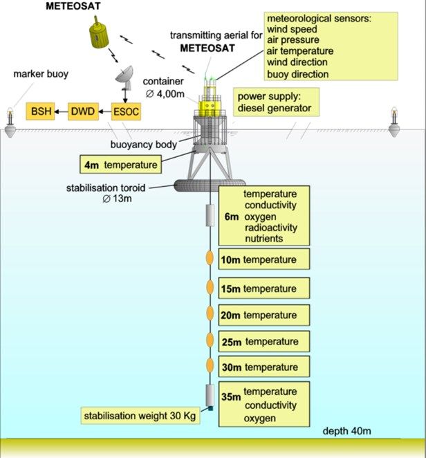
P3_17 Automated surface marine observations from European data buoys   DOI: 10.5281/zenodo.934373    Poli et al.

The oceanographic parameters generally include sea-surface temperature. They can also include sub-
surface sensors (measurements of temperature at various depths), measurements of salinity, and
(Eulerian) measurements of sea current. The sea-state is also of interest for several applications. This
can be measured by the displacement of the buoy, assuming that it responds to waves without
affecting the measurement. This is hence only true for waves that carry a minimal energy (large
enough to move the buoy). For that reason, wave buoys specialized to measure swell and wind-
generated waves of all sizes are generally designed as rather small (e.g., under 2 m diameter). Larger
buoys will indeed tend to suppress or dampen the small waves, and the readings for small waves will
need to be considered with caution. Several European sites also measure biogeochemistry
parameters, such as turbidity, chlorophyll, sound velocity, partial pressure of Carbon Dioxide or
Oxygen in sea water, but these are outside the scope of this paper. A collection of such sites are
indeed labelled as part of OceanSITES and/or FixO3 (Fixed-point Open Ocean Observatories).

A schematic picture of a moored buoy is shown thereafter for one moored buoy whose maintenance
is partially supported by E-SURFMAR (below, left, Drawing courtesy of FUGRO) , and another one
moored in the North Sea (below, right; mooring line omitted) in more shallow waters.

                           Meteorological sensors
                           (air temperature, wind
                            speed and direction,
                                  pressure)
    Directional wave
         sensor

     Oceanographic sensors
    (surface current velocity
          and direction,
       temperature, and
          conductivity)

The hull of the buoy ensures buoyancy and protection from the elements. The expected lifetime of
such buoy exceeds typically 10 years (more likely around 15-20 years). The other essential
components of a moored buoy are the power segment, the instrumentation and data processing
segment, the safety segment, and the transmission segment. The instrumentation and data
processing segment are generally bundled in Automatic Weather Station (AWS). For example, several
European countries have developed AWS systems for moored buoys, by looking for synergies with
other AWS systems used on land or on ships. Also, some moored buoys use two sets of electronics
and instruments in the AWS, to decrease the likelihood of one observed parameter going missing
between two maintenance schedules. The safety segment is meant to prevent collisions and
continue reporting the buoy position in case the mooring line breaks. The data transmission segment
is detailed in the following section.

Proceedings for ICAWS 2017                        22/09/2017                                        Page 3/8
P3_17 Automated surface marine observations from European data buoys DOI: 10.5281/zenodo.934373 Poli et al.
2.2 Drifting buoys
Unlike moored buoys, drifting buoys are designed to track
currents in a quasi-Lagrangian way. There are various sizes and
types of drifting buoys, depending on the type of ocean-
advected feature one wishes to track. For example, for oil spill,
a common buoy type is the CODE/DAVIS to track currents at
the very surface, given that the relatively low costs allow
employing many platforms to capture small-scale phenomena.
For tracking larger-scale ocean surface currents (i.e. at a lower
depth), the standard is the Surface Velocity Programme (SVP)
platform. Of a hemispheric shape, it includes a holey sock
drogue at a standardized depth of 15 meters below the surface
[4]. Due to the physical stress (wind vs current) this drogue is
typically lost within a few months, whereas the mean lifetime
of a functional drifting buoy is (at time of writing) around
500 days.
The largest drifter program in the world is NOAA’s Global
Drifter Program (GDP). It counts over 1300 buoys, including a
contribution by several European countries.
Additionally such buoys can report sea-surface temperature,
but also nowadays air pressure. More rarely the platforms
measure sea-surface salinity and sub-surface temperatures.
Trials have been made to also report wind and waves. The
figure on the right-hand-side shows a schematic picture of a
drifter as employed by E-SURFMAR (Drawing courtesy of
metOcean Telematics, drawn by Paul Jakobsen).
The drifting buoys use their own systems for data processing,
and are generally not bundled in what one could refer to as a
stand-alone AWS. Yet, there have been successful attempts to
use drifters as AWS on ships (so-called ‘deck-drifters’). These
solutions enable to give beached (but still functioning) drifters
a second (useful) life, while also providing data from ships
devoid of a weather reporting solution (AWS or human
observer with near-real-time transmission to shore).
The lifecycles of these buoys do not foresee maintenance at
present. Only in rare cases have buoys been recovered, and the
calibration of the instruments verified [5].
The data transmission from drifters is usually organized via
Argos, but nowadays an increasingly number of operators uses
Iridium satellites.
Proceedings for ICAWS 2017 22/09/2017 Page 4/8P3_17 Automated surface marine observations from European data buoys DOI: 10.5281/zenodo.934373 Poli et al.
3. Data segment
The data sent by operational buoys are relayed in a few minutes to a Data Assembly Center (DAC),
which depends on the buoy type, owner, and transmission choice. The DAC generally decodes and
controls the messages received, before posting them on the WMO Global Telecommunications
System (GTS).
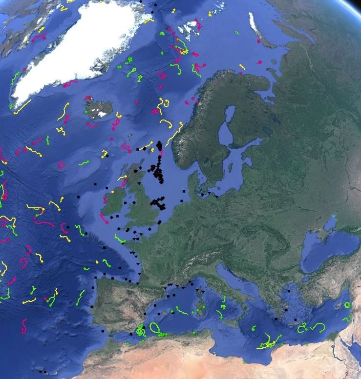
In European waters, the map in
the right-hand-side shows
positions of moorings and drifters,
for data received on the GTS
during the 15 days preceding 13
September 2017. Note that some
of the oil platforms equipped with
AWS are included. Moored buoys
are otherwise indicated with black
symbols, while drifting buoys
tracks (over the 15 days) are
indicated in colors.
The buoy data reported on the
GTS have the status of essential
data products under WMO
Resolution 40 Annex I, meaning
that they are provided on “a free
and unrestricted basis”, as
“necessary for the provision of
services in support of the
protection of life and property
and the well-being of all nations”
[6].
4. Applications
The data sent by buoys serve at least five broad classes of applications.
4.1 Weather prediction
The data reported by moored buoys are used by marine weather forecasters to assist in their
appreciation of numerical weather forecast scenarios. The meteorological data are also assimilated
in numerical weather prediction models. The knowledge of the pressure field for initial conditions
influences the quality of global forecasts up to several days, and high-resolution limited-area
forecasts as well. For longer time-scales, the knowledge of the sea-surface temperature (SST) field is
more critical. For this variable, the SST buoy data are used to improve the satellite estimates.
Proceedings for ICAWS 2017 22/09/2017 Page 5/8P3_17 Automated surface marine observations from European data buoys DOI: 10.5281/zenodo.934373 Poli et al.
4.2 Satellite validation and calibration
The data reported by moored and drifting buoys are used by satellite agencies to calibrate and
validate products derived from satellites measurements. This applies to retrievals of sea-surface
temperature (e.g., derived from passive infrared radiometers), sea-surface salinity (e.g., derived from
passive microwave radiometers), sea-state (e.g., significant wave height derived from altimeters),
and sea surface wind (e.g., speed and direction derived from scatterometers).
In all these cases, the past years have seen experiments, sometimes with partial support from space
agencies, dedicated at collecting additional data to evaluate and then further improve the
corresponding satellite products.
4.3 Climate studies
Data collected by the DACs and then further ingested in ICOADS [7] are typically used in weather and
climate reanalysis [8].
A process is underway to build a 3-tier architecture in the framework of the Marine Climate Data
System (MCDS), based on DACs, GDACs, and Centres for Marine-Meteorological and Oceanographic
Climate (CMOCs) such as ICOADS.
4.4 Oceanography
The ocean surface current data estimated from drifter trajectories are used to help improving the
retrieval of ocean current information from satellite altimeters. Conversely, the expert use of both
data can help detect when drifters have lost their drogues [9].
4.5 Industrial applications
Ground truth estimates of the wind are essential for the conduct of wind farm operations. The same
is true for the conduct of oil exploitation operations. Moored buoys may be used for this purpose.
However, one notes the gradual interest towards powered mobile measuring platforms that can
adopt a fixed position and be steered from one position to the next.
5. Challenges and evolution prospects
For moored buoys, one challenge amounts in protecting them from assaults and increased
vandalism. Indeed, buoys attract fish, which attract fishermen; the fishing lines and nets (when not
boarding the buoy) cause costly damages. Another challenge consists in spacing the maintenance
interval, to make ship visits more seldom. This will help reduce operation costs and raise the
prospects for continued measurements by moored buoys. Manufacturers should assist in this by
aiming to design moored buoy systems that require fewer visits. For example, a challenge would be
to design a system guaranteed to function for 2 years without intervention.
The prospects for moored buoys are to include more sensors so each site reports a host of
parameters relevant to more applications such as marine wildlife and understanding of the
ecosystem. One may cite for example the equipment of some moorings with acoustic sensors to
detect nearby passages of fish equipped with such beacons.
Proceedings for ICAWS 2017 22/09/2017 Page 6/8P3_17 Automated surface marine observations from European data buoys DOI: 10.5281/zenodo.934373 Poli et al.
For drifting buoys, the prospects are to equip them more routinely with more sensors, so that each
buoy journey reports a multi-variate picture of the environment travelled. For example, the GDP has
an objective of reaching 100% of all drifters reporting air pressure. Also, there have been successful
trials of wave measurements from drifters, reported at the 32nd session of the Data Buoy
Cooperation Panel (DBCP-32).
For both buoy types, there is an interest to increase the underlying metrology, so the measurements
can be used as references to calibrate and validate satellite products. This realization of benefits
through greater integration between in situ and satellite segments is one of the cornerstones of the
evolution towards the Tropical Pacific Observing System in 2020 (TPOS-2020).
The challenges for both platform types concerning sustainability are somehow different. While it may
be easier for a mooring not to leave behind any trace of its presence once the mission finished,
drifters pose specific problems. Their trajectories are not known in advance, and cease to be known
once the buoys stop working. For these reasons, it is extremely difficult to aim to recover drifters at
the end of their useful/operating life. Options to improve this aspect include developing recycling
schemes for those drifters that are recovered (e.g. beached), and looking to introduce a greater
share of recyclable materials in the manufacturing process.
One must note that today E-SURFMAR only uses alkaline-based batteries for its drifters, in spite of
some manufacturers of oceanographic equipment still proposing the options of using lithium
batteries, known to be far detrimental to the marine environment, if not recovered.
6. Conclusions
This paper reviews the types of buoys used for operational applications by (mainly) the
meteorological community. Moored buoys are rather complex systems, which can even integrate
redundant sets of AWS, to guarantee a high data return rate. Drifting buoys are relatively leaner in
design in comparison, but present a far shorter lifetime, with no expected maintenance cycle.
The advantages of buoys as autonomous platforms to collect data at sea will remain strong for as
long as no other surface autonomous is able to propose similar services for an equivalent cost. One
may expect however that challengers in this category will appear in the coming years, with
autonomous surface vehicles or drones, offering the possibility to recover the equipment and to visit
well-identified areas on demand.
References
[1] Records from the German Naval Archives microfilmed by the United States Navy, Office of
Naval Intelligence (ONI) at the Admiralty, London. T1022/Roll 2932/PG30079.
[2] Nimbus 6 Random Access Measurement System Applications Experiment (RAMS), 1982, Eds.
C. Cote, R. Taylor, and E. Gilbert. NASA SP-457, pp. 107 (on-line:
https://ntrs.nasa.gov/archive/nasa/casi.ntrs.nasa.gov/19830006564.pdf, last accessed 14
September 2017)
[3] The Argos system: monitoring the world’s environment, 1990, by K.R. Swenson and A.E. Shaw
III. Oceanography 3(1):60–61. DOI:10.5670/oceanog.1990.29.
Proceedings for ICAWS 2017 22/09/2017 Page 7/8P3_17 Automated surface marine observations from European data buoys DOI: 10.5281/zenodo.934373 Poli et al.
[4] Water-following characteristics of a mixed-layer drifter,1987, by P.P. Niiler, R. Davis, and H.
White. Deep Sea Res., 34, 1867–1882. DOI:10.1016/0198-0149(87)90060-4.
[5] Météo-France/E-SURFMAR HRSST (re)calibration, 2016, by P. Poli, G. Emzivat, P. Blouch, R.
Férézou, and A. Cariou. Scientific and technical workshop on traceability of drifter SST
measurements (SST-Drift), La Jolla, CA, USA, 13-14 October 2016.
DOI:10.5281/zenodo.890279.
[6] WMO Resolution 40, WMO Cg-XII, 1995, on-line:
http://www.wmo.int/pages/prog/www/ois/Operational_Information/Publications/Congress
/Cg_XII/res40_en.html (last accessed 14 September 2017)
[7] ICOADS Release 3.0: a major update to the historical marine climate record, 2017, by E.
Freeman, S.D. Woodruff, S.J. Worley, S.J. Lubker, E.C. Kent, W.E. Angel, D.I. Berry, P. Brohan,
R. Eastman, L. Gates, W. Gloeden, Z. Ji, J. Lawrimore, N.A. Rayner, G. Rosenhagen, and S.R.
Smith. Int. J. Climatol., 37: 2211–2232. DOI:10.1002/joc.4775
[8] The observation feedback archive for the ICOADS and ISPD data sets, 2015, by H. Hersbach,
P. Poli, and D.P. Dee. ERA Report Series 18, pp. 31 (on-line:
https://www.ecmwf.int/sites/default/files/elibrary/2015/9871-observation-feedback-
archive-icoads-and-ispd-data-sets.pdf, last accessed 14 September 2017)
[9] Use of Altimeter and Wind Data to Detect the Anomalous Loss of SVP-Type Drifter’s Drogue,
2012, by M.-H. Rio. J. Atmos. Oceanic Technol., 29, 1663–1674. DOI: 10.1175/JTECH-D-12-
00008.1
Proceedings for ICAWS 2017 22/09/2017 Page 8/8You can also read