Beyond The 'Binaries': A Methodological Intervention for Interrogating Maps as Representational Practices
←
→
Page content transcription
If your browser does not render page correctly, please read the page content below
Beyond The ‘Binaries’:
            A Methodological Intervention for
                 Interrogating Maps as
               Representational Practices

                          Vincent J. Del Casino Jr. 1
       Departments of Geography and Liberal Studies, California State University,
          Long Beach, 1250 Bellflower Blvd., Long Beach, CA 90840
                          email: vdelcasi@csulb.edu

                                Stephen P. Hanna
                 Department of Geography, University of Mary Washington,
                  1301 College Avenue, Fredericksburg, VA, 22401
                             email: shanna@umw.edu

Abstract

       Over the past two decades, a growing number of geographers and
cartographic historians have critically examined maps as products imbued with
power, the social contexts of map production, and the intimate involvement of
cartography in Western imperialism and the enlightenment project. More recently,
a few scholars have applied critical approaches to studies of map use and

      1
          © Vincent J. Del Casino and Stephen P. Hanna, 2006
ACME: An International E-Journal for Critical Geographies, 4 (1), 34-56 35
interpretation. Much of this work reproduces, at least implicitly, a series of binaries
that separate maps as representations of space from spatial practices. In this paper,
we offer a methodological intervention by introducing a theorization of ‘map
spaces’ as a way to move beyond the duality of representational and non-
representational theory in critical cartography. Methodologically framing how we
can interrogate the binaries of representation/practice, production/consumption,
conceptualization/interpretation, and corporeality/sociality upon which so much
analysis is based affords us the opportunity to challenge the presumptions of
critical cartography as either the study of mapmaking or map use. We use a tourism
map of Fredericksburg, Virginia to demonstrate how to ‘move beyond’ a critical
cartography that is based, as some suggest, in an analysis of representation and not
practice.
Keywords: Critical Cartography, Map Space, Representation/Non-Representation
Introduction
The map is open and connectable in all of its dimensions; it is
detachable, reversible, susceptible to constant modification. It can be
torn, reversed, adapted to any kind of mounting, reworked by an
individual, group, or social formation. It can be drawn on a wall,
conceived of as a work of art, constructed as a political action or as a
mediation (Deleuze and Guarttari, 1987, 12).
When does the moment of map production end? At the time when the
printing press stops rolling, or the crayon leaves the page, or when a yahoo map
stops loading, or perhaps when the finished map is found embedded between
columns two and three of the New York Times? Or, maybe, production never stops.
Maybe maps are constantly produced and (re)produced as is suggested through the
democratization of production in participatory GIS. Such questioning of
production, however, should be accompanied by similar questions about
consumption. When is a map first consumed? After it leaves the hands of its
authors? Do authors not consume their own representation, see themselves in its
images, reconstruct their own desires through this object, or dare we say subject?
Still, many critical cartographers (Black, 1997; Harley, 1988; Harley, 1989; Harley,
1990; Wood, 1992) maintain an implicit duality between production and
consumption, author and reader, object and subject, design and use, representation
and practice. They still focus on how maps are produced in particular social,
political, and economic contexts; or, they concentrate on the consumption and useBeyond the ‘Binaries’: A Methodological Intervention 36
of these particular objects in their post-production phase. Yet, maps, to borrow
from Gibson (2001) 2 , are in state of “becoming.” As such, maps stretch beyond
their physical boundaries; they are not limited by the paper on which they are
printed or the wall upon which they might be scrawled. Each crease, fold, and tear
produces a new rendering, a new possibility, a new (re)presentation, a new moment
of production and consumption, authoring and reading, objectification and
subjectification, representation and practice.
Maps are thus not simply representations of particular contexts, places, and
times. They are mobile subjects, infused with meaning through contested, complex,
intertextual, and interrelated sets of socio-spatial practices. As Deleuze and
Guarttari suggest, “the map has multiple entryways” (ibid., 12) and a myriad
number of possibilities because it operates at the margin and center simultaneously.
Maps are also not, as some may argue (e.g., Harley, 1989), fixed at the moment of
production, a result of the hegemonic authority embedded by the mapmaker in/on
the representation. Thus, while maps may be infused with power, and thus ripe for
deconstruction, it is not enough to demythologize the map (c.f., Sparke, 1995).
Instead, maps ought to be theorized as processes, “detachable, reversible,
susceptible to constant modification.” It is therefore appropriate to say that maps,
as representations, “work” (Wood, 1992). As we contend, representations, such as
maps, work because “they help make connections to other representations and to
other experienced spaces” (Hanna et al., 2004, 464) suggesting that maps do,
indeed, provide multiple entryways into how they are produced and consumed as
well as how they are used, interpreted, and constituted.
In this paper we are particularly concerned with interrogating the binaries –
such as representation/practice, production/consumption, map/space – upon which
critical cartography and critical GIS are partially based. This is a methodological
intervention because, like Harding (1987, 3), we view methodology as “a theory
and analysis of how research does or should proceed.” This suggests that
geographers must first ask how they conceptualize and frame their questions and
data. In offering this critique, however, we are not simply moving toward a non-
representational theory of maps and mappings as practices (Perkins, 2004), at least
as Thrift (1996) has conceptualized the non-representational (see critiques of Thrift
by Nash, 2000; Smith, 2003). Instead, we are interested in pushing our
methodological (and by default our epistemological and ontological) assumptions
and processes toward thinking of maps as spaces. As such, maps and mappings are
both representations and practices (read: performances) simultaneously. Neither is
fully inscribed with meaning as representations nor fully acted out as practices. As
Nash (2000, 662) avers we must “allow room for considering visual and textual
forms of representations as practices themselves.” As will be argued and shown
2
Gibson is drawing here on the work of Judith Butler (1997) and William Connolly (1999).ACME: An International E-Journal for Critical Geographies, 4 (1), 34-56 37
through a case study, it is rather beneficial, therefore, to talk about map spaces
instead of maps and spaces. As we have argued elsewhere “Any critical perspective
of mapping must…investigate the multiple historical and spatial referents that are
part and parcel of any…map. This compilation of referents comes together and
constitute what we call a map space” (Del Casino and Hanna, 2003). In this paper
we extend this argument further, examining maps and mappings as experiences,
practices, and, more importantly, following Butler (1988; 1990; 1993), as
performances.
We examine these issues in the following three sections. Beginning with a
discussion of critical cartography, we examine the ways in which some of the
binaries listed above are reproduced in this literature’s theoretical discussions. We
suggest that collaborative GIS research may offer a partial opening for rethinking
the binaries upon which mapping is based, but argue that we must push this
analysis even further by theorizing those collaborations as performances that are
parts of the reflexive bodily actions of social actors working with, in, and through
maps and mapping processes (c.f., Edensor, 1998). Next, we offer a critique of the
‘non-representational’ and how this particular body of work has been deployed in
discussions of geographic practice. Specifically, we argue that a non-
representational cartography might limit (or even eliminate) any discussion of
representational practice in critical cartography and GIS by severing the reflexive
from the non-reflexive and bodily acts from conscious and unconscious thought.
Finally, we offer an example that might help further push how we go about ‘getting
at’ the messiness of everyday life that is embodied through the work of mapping
the world. What we want to suggest is that representations are not simply visual
objects ripe for deconstruction. Representations, maps included, are tactile,
olfactory, sensed objects/subjects mediated by the multiplicity of knowledges we
bring to and take from them through our everyday interactions and representational
and discursive practices.
We do this through a brief examination of a tourism map that is part of the
everyday experiences of both tourism workers and tourists traveling to
Fredericksburg, Virginia. Like other heritage tourism spaces, Fredericksburg’s
success as a destination depends on making its past(s) present, accessible, and
attractive for tourist consumption (Shields, 2003). This requires not just the
production of representations, including maps, but their use by tourism workers and
tourists as integral parts of experiencing this historic city. The case study presented
here is drawn from continuing research on Fredericksburg’s changing heritage
tourism space. Specifically, the quotations are drawn from interviews conducted in
Fredericksburg in 2001 and 2002 with workers at Fredericksburg’s Visitor’s Center
and the owner of a private trolley-tour company. These interviews were organized
to solicit information about how tourism workers interact with visitors to the City.
Each informant was provided with an introduction to the research and asked to
comment, generally, to a number of open-ended questions that asked about howBeyond the ‘Binaries’: A Methodological Intervention 38
they were trained, what role they played at the Visitor’s Center, and how they
interacted with visitors. In particular, we were interested in gathering information
on how these tourism workers worked the city as a representational space. In
addition, we hopped aboard the trolley tour and conducted participant observation
in a number of tourism spaces throughout the city. During these moments of
participant observation, various acts of public behavior amongst tourists were
observed. Also, during these moments of interaction, cues from the trolley tour
operator/driver were collected. Moreover, Stephen Hanna is a resident of
Fredericksburg who actively participates in the everyday contexts we discuss
below through his ongoing research on heritage tourism in the city. In so doing, he
has further observed the public behavior of ‘touring’ Fredericksburg through daily
interactions with tourists visiting Fredericksburg.
On the ‘Critical’ in Critical Cartography (and GIS)
As most are now aware, the age of ‘critical cartography’ was ushered in
during the late 1980s prompted largely by the work of historical geographer, J.
Brian Harley (1988; 1989; 1990). Although cartographers themselves launched
several internal critiques of their own work throughout the 20th century (e.g.,
Peters, 1990; Tyner, 1982; Wright, 1942), Harley (1989) offers a distinct challenge;
the development of a critical cartography depends on cartographers engaging in the
theoretical innovations taking place in human geography more broadly. For Harley,
geography’s growing concern with the social theoretical advances of
deconstruction, and with the work of Derrida and Foucault in particular, influence
his own theorizations of maps and mapmaking. Relying on these theories, he
suggests that cartography, as a practice, and maps, as social products, are
inextricably tied into various systems of power and knowledge. “Like the historian,
the map maker has always played a rhetorical role in defining the configurations of
power in society as well as recording their manifestations in the visible landscape”
(Harley, 1988, reprinted in Harley, 2001). Following Foucault’s theorizations of
power-knowledge, he is thus critical of any intellectual practice that cleaves
differences along an “arbitrary dualism” (Harley, 1989, 11, as cited in Crampton,
2001, 240). This includes, for example, the distinctions cartographers traditionally
made between “propaganda versus true maps, or scientific versus artistic maps”
(ibid.). Harley, therefore, like other deconstructionists and critical cartographers
(Black, 1997; Gregory, 1994; Pickles, 1992, 1995, 2004; Sparke, 1998; Wood,
1992; Wood and Fels, 1986; Woodward, 1991), remains skeptical of the binary
logics that seek to privilege one set of knowledges over an ‘other.’
Of course, Harley is not without his critics who challenge his reading and
interpretation of the work of Foucault and Derrida (e.g., Belyea, 1992, Sparke,
1995). Belyea (1992, 1), argues that Harley’s presentation of his work as
“deconstruction” is misleading and that he still “accepted without question theACME: An International E-Journal for Critical Geographies, 4 (1), 34-56 39
orthodox definition of maps as images of the world.” Agreeing with Belyea, Sparke
(1995) suggests that Harley confuses demythologizing a map with true Derridian
deconstruction. As a result, Harley’s analyses tend to fix a map’s meaning at the
moment of production. Moreover, we suggest elsewhere that,
Harley’s incomplete dialectic between space and representation is
a…limitation of his critical cartography. Although he seeks to break
the mimetic and unidirectional link from space to representation that
dominates cartography, his flawed deconstructionist method seeks to
find the real power relations in some space that is outside of and
concealed by the map (Hanna and Del Casino, 2003).
Crampton (2001) notes that Harley’s theoretical developments were cut
short by his untimely death; he was never able to provide a complete critical
methodology of maps and mappings. “Deconstruction might reveal what the map
was not (i.e., innocent, scientific, optimal), but what is left to say about what the
map is?” (Crampton, 2001, 241). That said, Harley does “emphasize the
importance of multiple perspectives and multiple maps” (ibid., 244) and, therefore,
provides a starting point for thinking about maps and mappings as more than
simply pieces of paper designed to communicate and represent information about
various places and spatial patterns. As Crampton argues, “the production of
multiple maps … [in the context of] geographic visualization, which overturns the
communication model by promoting exploration rather than presentation,
contingency rather than finality” (ibid., 244), might provide a new way forward.
Geographic visualization is informed by scholars, such as Wood and Fels
(1986), who draw their inspiration from semiotics and the analysis of signs.
MacEachren (2004) argues explicitly for using semiotics in the analysis of “how
maps work” at both the individual and societal level simultaneously. Cartographers
must investigate maps, not as communicative devices, but as representations.
Maps, like other representations, are open to interpretation, contested, and mutable.
Informed by structuralist 3 conceptualizations of semiotics, MacEachren (2004,
242) argues that “a semiotic perspective offers a structured way to consider the
interaction of the explicit and implicit meanings with which maps are imbued.” As
such, maps are more than simply devices of communication produced by
cartographers, they are also constructed by map-users who bring their
understandings to the map in a process by which they “develop a consensus about
3
What we want to suggest is that MacEachren (2004), while on one level opening up the
possibility of multiple interpretations of maps as representations, fails to take on the underlying
structuralism that identifies and orders signs into a system to find deep and universal rules that
produce surface meanings. This is, perhaps, also a result of his dependence on cognitive theories of
map use and interpretation. This might also be tied to his general interest in a particular type of map
product, one developed by professional cartographers.Beyond the ‘Binaries’: A Methodological Intervention 40
letting symbols (in the broadest sense of the word) stand for objects, relationships,
events, and the like, in the ‘real’ world” (MacEachren, 2004, 14). This process is,
of course, never complete, as map-users can produce a multitude of interpretations.
The production of “multiple maps” offers the opportunity to democratize
cartographic production, at least theoretically (c.f., Ghose and Elwood, 2003). It
also exposes the “hidden” a priori decisions that are made before and during map
production and thus challenges the hegemony of cartographers over the
mapmaking process (Crampton, 2001). Crampton’s suggestion that critical
cartographers use the approaches of geographic visualization thus partially upends
the binary logic of map producer and map user. This echoes the earlier calls of
Wood (1992), who ends The Power of Maps by criticizing the arrogance of
professional cartographers who worry about “cartographic problems” and praising
people who make their own maps to serve their own interests. In fact, the push
toward more collaborative cartographies and geographic information systems (GIS)
has become an important part of the growing critical literature on maps and
GI/Science (e.g., Ghose and Elwood, 2003; MacEachren, 2000; as well as the two
special issues of the URISA Journal in 2003 dedicated to participatory GIS). For
the most part, this work is focused on how the participatory context functions
between various actors. But, like Crampton’s and MacEachren’s discussion of
geovisualization, there are several potential limitations to this analysis. Most
importantly, there remains in this work a lingering emphasis on authoring,
production, and writing. The only way a map becomes something more than what
Harley envisioned is if users become involved in the production process. It is not
surprising, therefore, that Pickles (2004, 35) suggests
[w]hile the limitations of a communication model for understanding
map-making and map use soon became apparent, subsequent
attempts to model the mapping process quickly approached the
baroque…Cartographic representations continued to be
conceptualized as the technical transfer of real-world information to
users…It left cartography in the Kantian dilemma of how it knows
the world and how it can represent the ‘real’ world adequately to
control the misreading of map users.
Thus, while semiotic analyses of the communication model are now fully
embedded in the self-critique of the practice of cartography, and cartographers like
MacEachren (2004, 459) fully recognize that map users “yield multiple alternative
representations” of a single map, other scholars have chosen to turn more directly
to poststructuralism as way to theorize maps and map use.
The turn to poststructuralism suggests that a focus on the democratization of
mapping, albeit unintentionally, may marginalize the consumptive processes of
mapmaking, maps, and mappings. It may also fail to take into account the
constitutive nature of consumption as production and reading as authoring, whichACME: An International E-Journal for Critical Geographies, 4 (1), 34-56 41
is critical to poststructuralist theories of representational practices (c.f., Barthes,
1978). Further, it delinks maps from spaces by pushing aside the intertextuality and
relationality that are part and parcel of the relationships between spaces and
representations. This is not to suggest that there is some “real” space out there.
Rather, it is to argue that all spaces are always already representations that are
produced by and productive of a myriad number of bodily practices and
performances as social actors draw on their intertextual knowledges while
reauthoring both space and representation simultaneously. This echoes Butler’s
theorization of sex not as a fixed, real identity but as a ritualized set of
performances.
…[C]onstruction is neither a single act nor a causal process initiated
by a subject and culminating in a set of fixed effects. Construction
not only takes place in time, but is itself a temporal process which
operates through the reiteration of norms; sex is both produced and
destabilized in the course of reiteration. As a sedimented effect of a
reiterative or ritual practice, sex acquires its naturalized effect, and,
yet, it is also by virtue of this reiteration that gaps and fissures are
opened up as the constitutive instabilities in such constructions, as
that which escapes or exceeds the norm… (1993, 10, her emphasis)
Applying this to maps and mappings, we suggest that the reiterative
processes of consuming maps may temporarily ‘naturalize’ maps as somehow fixed
in their meaning. And yet, the very act of consumption through the performance of
maps offers productive possibilities, particularly through the emergence of
constitutive spaces at/in the “gaps and fissures” of the mapping processes. And,
yet, there is no deep underlying structure that somehow organizes this overall
process.
Thus, investigating cartographic collaboration may involve, as Harvey
(2001, 30) notes, studying “the traces of relationships between people, institutions,
and artifacts [as they are] connected by agreements and exchanges.” Working
through actor-network theory, Harvey emphasizes that there is nothing “natural”
(ibid., 31) about the separations between map producers and users, representations
and practices, or the technologies and artifacts that mediate the relationships
between the various “nodes” in any given network of social actors. As Harvey
(ibid., 30) further explains, actor-network theory has real methodological potential
for breaking down the boundaries between production and consumption, author and
reader, map and space because “[t]echnical artifacts [such as maps] are much more
than surrogates for certain humans; they are actors who bundle multiple intentions
and act in ways that complement and extend humans.” In actor-network theory, we
are interested not in some deep relationship between structures and agency; rather,
attention is paid to the “traces” between networks and actors (Mol and Law, 1994
as cited in Harvey, 2001, 30). These traces, discursive and material residuals left by
the reiterative process, are part of actor-network processes that produce,Beyond the ‘Binaries’: A Methodological Intervention 42
temporarily perhaps, a “common ground” (ibid, 31) among actors in the network.
They do not, however, point to any original moment, but rather constitute a
complex and spiraling web of socio-spatial relations informed by a myriad number
of discourses and practices. Following Harvey’s theorization, we are closer,
perhaps, to critiquing the binary logic of production and consumption in critical
cartography that typically privileges the production context over the mundane uses
of maps and mappings.
Poststructuralist actor-network theories parallel, in some regard, the work of
Matthew Sparke (1995) who suggests that “Following Derrida . . . enables us to
demythologize while being more wary, and less romantic, about uncovering ‘true’
places and constructing ‘true’ maps.” (1995, 4). Ultimately, he hopes that
deconstruction “urges us to go back and look for other ways in which the map, and
what is supposed to lie outside of it – power relations, interpretations of the ‘real’
world, etc. – might actually be still more complexly interrelated” (ibid). In both
cases, maps are not theorized as closed off objects nor are their meanings and uses
fixed by either production or by academic critique. Instead, maps are
conceptualized as working because they are practiced – reading, like authoring, is a
practice – and performed in various socio-cultural and political-economic contexts.
These poststructuralist turns in critical cartographic and GIS analysis pose
interesting challenges to the traditional binary logic of re-presentational – as
opposed to representational – theories of map communication and production. As
Dixon and Jones (2004, 88) argue “[p]oststructuralists take note of and critique
forms of thought that distinguish between the ‘real’ world and its ‘mere’ re-
presentation in communication, whether conceived in terms of language, sensory
perceptions, or electronic media.” Poststructuralists are interested in not only
challenging the binary logic of “real” and “re-presented,” they are also interested in
deconstructing the tensions that are part and parcel of all binaries. As in actor-
network theory, poststructuralist representational theories are not interested in how
we communicate truth or reality. Rather, there is “no signifier [that] can be
presumed to stand in a one-to-one relationship with a real-world referent” (Dixon
and Jones, 2004, 88). As such, representations, such as maps, “work” because
social actors use them in ways that may reify dominant ideologies. At the same
time, maps “work” as social actors perform the very mundane act of using maps
and mappings in everyday interactions in ways that open up productive moments of
resistance (cf., Foucault, 1997). Such a theorization suggests that we might turn our
attention toward how maps and mappings are practiced beyond the productive
moments of making a map or constructing various mappings. Some have suggested
that non-representational theories might open up the possibility for rethinking how
maps as objects are tied to various practiced contexts (Perkins, 2004). We,
therefore, want to briefly turn to non-representational theories of practice and ask if
they help us move from maps as products to maps as practices.ACME: An International E-Journal for Critical Geographies, 4 (1), 34-56 43
On a Non-Non-Representational Geography of Maps and Mappings 4
Perkins (2004, 381) recently noted that “nonrepresentational theory that is at
once critical but also concerned with culture and politics” now informs the growing
study of “map use and mapping practices” (following Thrift, 1996). It seems to us
rather odd, however, that the uses and practices of mapping might be framed by
theories that purport to be nonrepresentational. What we want to suggest is that it is
not necessary to conflate all theories of practice and performance with
nonrepresentational theory. And, in the case of maps and mappings, it may be
somewhat counterproductive to do so because it may reinscribe the binary logic of
representation and practice that limits our theoretical possibilities.
The appropriation of Thrift’s (1996) nonrepresentational theory by cultural
geographers tends to presuppose an ontology of real emotions, experiences, and
senses that somehow make representations less real. As Nash (2000, 655) argues,
“nonrepresentational theory moves away from a concern with representation and
especially text since, Thrift argues, text only inadequately commemorates ordinary
lives since it values what is written or spoken over multisensual practices and
experiences.” In this way, Nash suggests that Thrift is suturing representations to
texts theoretically. And, indeed, Thrift does critique the textual turn in cultural
geography for its focus on the textual and visual at the detriment of the other
senses. Deconstruction is thus a limited methodological framework for Thrift
because of its focus on textuality (Nash, 2000, 656). Nash argues that Thrift’s
appropriation of performance theory is potentially limiting, however, because he
positions one end of the binary over the other, practices are more experiential than
representations. We tend to agree: “a dichotomy between representation and non-
representation, while perhaps a valuable heuristic, does little to forward our
thinking about how place is performed. Rather, we argue that representations are
material practices and are intertextually constructed through the daily actions” of
various social actors (Hanna et al., 2004, 462). Moreover, Thrift’s
nonrepresentational theory detaches representations from the spaces they claim to
represent. Following Smith (2003, 76) 5 , however, “it is no longer the case of
4
This play on words is taken from Geertz’s (1984) article “Anti-Anti-Relativism.”
5
Here smith is suggesting that we can move toward a non-representational theory. But, that
theory, following the work of Baudrillard, is very different than Thrift’s, which Smith suggests is
actually “anti-representational” (2003, 68). By nonrepresentational, therefore, Smith means that the
world of representations no longer represents anything, i.e., “simulation is the situation created by
any system of signs when it becomes sophisticated enough, autonomous enough, to abolish its own
referent and to replace it with itself” (Baudrillard, 1991a as cited in Smith 2003). Pushing these
even further, Smith argues, again working through Baudrillard’s theories, that we are now working
through a “fractal stage of value – our current scheme is that of the pure simulacrum, where there is
no point of reference and no law of value” (ibid., 71, his emphasis). We are much more sympathetic
to this reading of nonrepresentational theory.Beyond the ‘Binaries’: A Methodological Intervention 44
having either maps [e.g., representations] or territories [e.g., spaces] because the
distinction between the two has vanished.” Instead, it is better to theoretically
consider maps and spaces are co-constitutive. Methodologically, Thrift’s approach
thus marginalizes the value of deconstruction, which we want to argue usefully
teases out the constitutive and relational nature of discourses and practices, social
and material experiences, and representations and spaces.
If we follow Thrift’s logic, maps are merely textual and not spatial objects.
They are constituted through the production of visual representations of space and
not through mundane spatial practices. It is our contention, however, that if we turn
to the performance theory of Butler, as Nash does, and work through identity
theory (c.f., Natter and Jones, 1997), we come to a different rendering of the map-
space relationship – one which collapses the binary logic of text and space and
experience and representation around which Thrift’s non-representational theory is
centered. These theories of performance and identity are also important to
understanding the emergence of what we call map spaces. We use this term to
denote the theoretical impossibility of disentangling representations from
performances. Map spaces are always partial and incomplete, contested sites where
the collisions of various identity and subject positions blur the boundaries of center
and margin. “While maps draw meaning from and help to define the spaces and
identities…they contain uncertainties and traces of excluded others that introduce
potential ambiguities in their relationships with space and identity” (Del Casino
and Hanna, 2000, 24). Those ambiguities are performed through various bodily
actions that often push the meaning the map beyond its intended use even in a
participatory context (Curran, 2003; DeLyser, 2003; Shields, 2003). We can,
however, deconstruct the ways in which these ambiguities become temporarily
sutured to various spaces and identities through the performative and repetitive
practices of social actors.
Thinking about map spaces in this way means neither the production nor the
consumption of maps is separable from space in the most mundane of settings.
Maps that people simultaneously make and use mediate their experiences of space.
People’s bodily practices of walking, driving, touching, smelling, and gazing, as
well as their understandings of landscapes and places can be guided and informed
by maps and by the innumerable intertextual and experiential references always
present in any map. At the same time, spaces mediate people’s experiences of
maps. For example, the physicality of a monument and the emotions it brings forth
lends meaning to its symbol on a map (Dwyer, 2000, 2003). The everyday
movements and distractions always present in spaces interrupt and interfere with
both the reading and making of maps. When driving we must pull over and stop to
look at a map or risk a traffic accident. Our theorization, therefore, does not
prioritize writing over reading or production over consumption in the constant
recreation of the map space. Nor do we wish to argue that map spaces as
representation are separable from map spaces as practiced, worked, or performed.ACME: An International E-Journal for Critical Geographies, 4 (1), 34-56 45
Therefore, we want to illustrate, with a brief empirical example, how map spaces
work in the daily lives of those who work and live in and through them.
Possible Openings and Methodological Interventions
In this section we want to suggest that there might be an alternative to
thinking through the binaries of design and use, representation and practice,
objectivity and subjectivity that undergirds much of the critical cartography
literature by suggesting how map spaces as performed “work.” We do this through
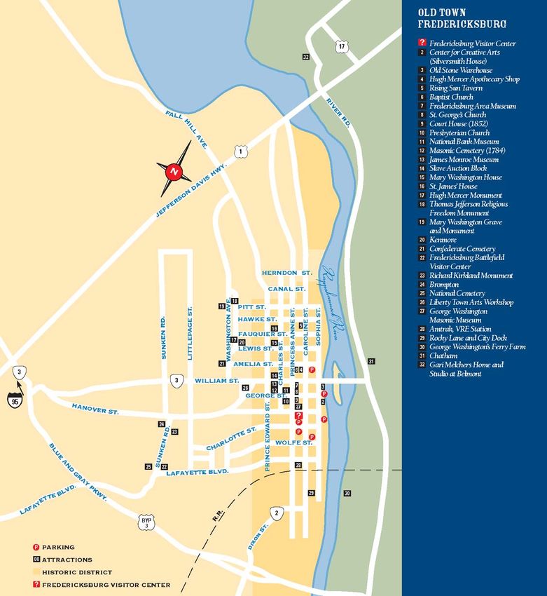
a brief examination of the use of a tourism map of Fredericksburg, Virginia (Figure
1). In a previous work (Hanna et al., 2004), this map 6 was used as illustration to
support an argument that tourism workers represented Fredericksburg as part of
their everyday bodily labor. Here, we want to center our discussion on the map
space, as written, read, performed, and consumed, and use it as a site through
which to offer our methodological intervention.
This simple map can be used to explore “Historic Fredericksburg,” the
downtown section of a small city located halfway between Washington, DC, and
Richmond, Virginia. Thirty-one numbers rest on a background of white streets
against muted golds, greens, and blues. The numbers, which match those found on
blue metal signs standing in front of historic homes, vistas, and monuments, are
identified as points-of-interest in a blue column along the right edge map. The
signs effectively staple the map to Fredericksburg’s heritage tourism landscape.
Whether given to a tourist by workers at Fredericksburg’s Visitors Center or
downloaded and printed off the Visitfred.com website, this map space – and the
intertextual and experiential connections brought to it through use – invites people
to explore Fredericksburg as a colonial port city, as the home of founding fathers,
and as an urban Civil War battlefield.
Even if accessed online, this map is not designed for tourists to share in its
production. Like any paper map, this PDF file has no links to a database or
hyperlinks to other webpages describing the sites marked on the map. Map users
cannot easily add their own points of interest to the map except perhaps in the old
fashioned way – taking pen or pencil to a paper version. Therefore, in order to
facilitate exploration and, thereby, to reproduce Fredericksburg as a heritage
tourism space, the map must be consumed. This takes place in conjunction with
other knowledges and texts, with interactions between tourists and tourism
workers, and with bodily practices ranging from clicking around the City’s website
6
This is an updated version of the map previously analyzed. The map shown here was
downloaded from the “Fredericksburg: Timeless” website, which is located at the following URL:
http://www.visitfred.com.Beyond the ‘Binaries’: A Methodological Intervention 46
Figure 1: Tourism Map of Historic Fredericksburg
to walking or driving the route taken by Union soldiers as they launched futile
assaults on Confederate positions above the town. In other words, the map space of
Historic Fredericksburg is performed.
This performance may occur in a variety of contexts. Tourists who enjoy
spending time planning out the details of their trips prior to leaving their homes can
use the rest of the Visitors Center website and other textual or pictorial sources to
imagine their visit to Fredericksburg. The visit itself, if it actually occurs, may then
follow the model described by John Urry (Rojek and Urry, 1997; Urry, 1990,ACME: An International E-Journal for Critical Geographies, 4 (1), 34-56 47
1995). The tourist’s gaze is directed, but not determined, by preconceived notions
created by the map and the other representations the tourist brought into the map
during consumption. Even in this context, however, it would be wrong to say that
the map space of Fredericksburg is reproduced through “merely” representational
acts. The tourist’s hands and eyes work to connect numbered sites on a map with
descriptions of places, histories of events, and biographies of people that stimulate
her or his interest in this tourism space. Yet, such intertextual consumption is far
from the only way the map space is performed.
Consider the tourist who begins her exploration of Fredericksburg at the
Visitors Center. She will be greeted by one of Visitor Councilors who are trained to
help tourists match their desires and interests to the right numbers on the map. As
Bill, a Fredericksburg Visitor’s Center Volunteer explains, “... I would suggest that
they see our fourteen minute video that we show on Fredericksburg. It is much
easier to draw a map and tell people about the map if they have some knowledge of
what’s it all about.” At the conclusion of the film, the tourist may ask for directions
or for suggestions about how to experience the town in a particular amount of time.
In the words of a second Visitor’s Councilor, such discussions usually take place
over the map.
I tell them where they’re located. Tell them that they don’t have to
go back out and put that parking permit on the car until they leave
the building. And then I tell them where we are, and tell them this is
Caroline St., which is the main street. And, I tell them this is the
apothecary, the Rising Sun tavern, this is where George
Washington’s mother lived. His sister Betty lived here at Kenmore.
This is where James Monroe practiced law . . . I tell them that this is
the colonial history. That everything is within walking distance . . .
and then I point out that about a mile south is the Civil War era. . . .
This is the Fredericksburg Battlefield Visitor’s Center, the stonewall
on Sunken Road, and the battle of Marye’s Heights.
In such an interaction, both tourism worker and tourist are consumers and
producers. The Councilor needs the map to perform her job; she helps tourists
explore Fredericksburg. A tourist uses the map to find attractions, but also to begin
organizing her or his knowledge and imagination about the town’s history. In this
way, the bodily interactions between representation, reader, and the various spaces
the representation claims to mark reproduce both Fredericksburg and the map as
both a city and representation simultaneously.
Yet, the map space is not only performed verbally. The route of a privately
run trolley tour, in large part, follows this map. Thus, visitors may trace out the
map as trolley drivers offer insight into the city. In the following quotations, the
owner of the trolley company, Butch Weimer, suggests how he ‘mapped out’ the
city for tourists.Beyond the ‘Binaries’: A Methodological Intervention 48
I visited all of the attractions when I was putting together the route,
and then on the way there were things to see and I researched those
to see what their significance was, and I think that on the route that
we run, it is about a six mile route to each tour, and I can’t think of
much that we leave out. All of the major points and a number of the
minor points. There are some stone markers and steel markers
around town and we explain their significance …
Like the map, the physical act of driving the trolley from site to site while
giving a narration helps visitors connect the dots represented by the stone and steel
markers set into the landscape. And, to an extent, the tour and therefore the map
space seem fixed. As Weimer continues,
It’s that you can’t change history. It’s the same story. You know,
what am I going to say different. I can’t change it. I keep trying to
pick up new stories to tell, things to put in. And people on board,
they’ll tell you a story, and sometimes you know you can use that.
You can’t change it. I thought about changing the route, let’s go
backwards one year. Just to be different. The streets are one way. I
can’t go but one way.
He does acknowledge, however, that the tour works, not because he and his
drivers produce a narrated map, but because his riders must consume this map
space in order to reproduce it. When asked if he and his drivers get tired of giving
the tour, he stated that, “its not boring, because every tour is a new group of
people.” He elaborated further,
Look at the people in the back and you can see the ones that are
laughing and you can see the ones that aren’t and you just keep
going and playing to them. You’ll get groups on board that sit there
like they’ve just paid their taxes, they’re the most unhappy bunch
that I’ve ever seen and you think “God, let me get through these
seventy five minutes, get these bums off of here, and get some LIVE
people” and they’ll get off and they’ll be the ones that come up and
say, “man, that’s the greatest tour I’ve ever been on,” they’re so
involved, you think they’re not paying attention, they are listening so
intently and they tell you all this stuff and you think, “why don’t you
let your face know that you were having a good time.” Because,
looking in that mirror was like “aw get this over with, get these
people off of here.” And they’ll be the people who put the most tips
in the hat. Because they weren’t there for the fun and games, they
were there for the history.
Map consumption thus also involves the arrangement of bodies, as tourists
move through the map space that is part and parcel of the trolley-based narrative.ACME: An International E-Journal for Critical Geographies, 4 (1), 34-56 49
This is a productive process. Tourists engage in the (re)production and
consumption of this space simultaneously through the asking of questions, reading
along on a paper mapped representation of the city, marking the map and making
other notes. Alternatively, tourists may focus on creating their own map space of
historic places and sites of interest as they listen to, or ignore, the directions of the
trolley driver.
As in the work of the trolley tour operators, the Visitor’s Councilors also
participate in the map spaces of tourism: “we’ll mark the map for them [tourists]
and show them what we have to offer. [We’ll] give ‘em a parking permit, first of
all, ask them where their parking and give them a parking permit and then they go
in and see the movie and they come out and I mark the map.” The organization of
tourists by Visitor Center Staff echoes Shields’ (2003, 9) argument: “Bodies are
‘spaced’: the performative carriage of the body, the gestures, actions, and rhythms
of everyday routines deemed socially appropriate to a particular site, are etched
onto place and into the somatic memory of individual inhabitants.” As such, maps
are intertextually performed, constitutive of multiple performances of identities and
spaces.
These bodily interactions do not fix this map space for tourists. When they
leave the Visitors Center, map in hand, they are free to explore the map space as
they desire. To some, this means boarding the tourist trolley and experiencing the
sites on the map, and many others, while gazing out the window and listening to
the driver’s narration. Others may choose to walk the route – a physical act which
undoubtedly changes their experience. Still others may limit themselves to sites,
homes, and monuments related to George Washington’s life history, perhaps
suturing this representation temporarily to a series of emotions including
nationalism and patriotism.
For example, three tourists walked through downtown Fredericksburg in
August 2005. 7 A woman held the tourism map and tried to tell her two male
companions where they were and where they wanted to go. As she crossed a street
and trudged up a hill, she looked only at the map. She seemed unaware of the
historic buildings and shops lining the street. The two men were not focused on
their present landscape either. The younger of the two questioned the woman's
ability to read the map while the older one struggled to keep up. All in all, their
performance of and in this map space suggests they were between sites of interest.
Their interactions with the map all but erased the immediate surroundings from
their senses. Their positions on the map, whether checked physically or mentally,
7
This experience was recorded as part of Stephen Hanna’s ongoing research on tourism in
Fredericksburg.Beyond the ‘Binaries’: A Methodological Intervention 50
were confirmed by the numbered blue signs or, perhaps, by interactions with other
tourists, residents, or tourism workers.
Through performances such as this one, tourists reproduce and alter the map
space with their bodies and minds. They also employ other senses as they absorb
the smells of foods from the restaurants or touch the antiques that are ubiquitously
placed throughout the city’s downtown shops. In some cases, the mapped
representation in their hand becomes part and parcel of those experiences, a
keepsake used to remember Fredericksburg as a place. Tourists may also assume
positions of interest and respect while listening to a costumed guide describe Mary
Washington’s life in Fredericksburg and, perhaps, they imagine a version of the
town’s past informed by both the guide and their own experience and knowledge.
In other words, tourists may just do what they want, map in hand. As
another Visitor’s Center staffer described,
They usually have in mind what they want to do. Some of them may
even just want to go out and walk. Some might look in the shops. Or,
they are interested in just walking and looking for someone to go to
eat. Depends on what they have on their minds. Well, like some
things they’ve already decided you know they are not going to go to
some of the places.
Thus, the mapped representation can always be exceeded and used in
different ways as individual social actors mark the map with restaurants, antique
shops, or new objects of their own personal historical interest. As such, maps are
never fully complete nor are they ever completely inscribed with meaning through
production. Rather, consumption is production. Map spaces are processes, fluid and
contested, although they find themselves temporarily fixed through certain
practices of consumption that (re)produce these objects in new and unique ways.
Conclusion
I am suggesting an ‘end of cartography as we knew it’ 8 or that
‘cartography is not what you think’. It is and perhaps has always
been a multitude of practices … lines of flight … coded and recoded
by forms of institutionalized power, but always with leakages. This
decentering of hegemonic formalization of techno-scientific
capitalism opens mapping to its own plurality of socio-spatial
practices, to its own geographies, to its own conflicted and highly
8
Pickles is paraphrasing Gibson-Graham (1996) here.ACME: An International E-Journal for Critical Geographies, 4 (1), 34-56 51
contested nature, and to its many roles in inscribing lines and
delimiting identities in the modern world (Pickles, 2004, 189).
If cartography has always already been a partial and contested set of
practices and performances, then it makes sense that maps, such as the one
discussed above, are also always in the process of production and consumption,
authoring and reading. Methodologically, what this suggests is that ethnographic
and other qualitative methodologies may be deployed to ‘capture’ the performed
identities of map spaces. As Perkins (2004, 386) argues, “recent ethnographic
approaches have investigated everyday social experiences of places and the role
that mapping practices play in identity and knowledge construction…An
ethnographic approach [thus] reorientates theory so that mapping becomes a social
activity, rather than an individual response.” But, what we want to further suggest
is that ethnographic studies of maps and mapping need not work on the side of
either production or consumption, representation or practice. Rather, the two sides
of these binaries are constitutive. While we have suggested how maps “work” after
a cartographer has designed a tourism map, we could examine how cartographers
also consume objects, spaces, and representations in their reworkings of their own
subjects. A critical cartography and/or GIS thus needs to further blur the
boundaries of production and consumption, author and reader, subject and object if
it is to truly become participatory and democratic.
This is a methodological concern because it is about that meso-level
moment when we temporarily suture our own epistemological assumptions to the
question of what are data and how we might go about collecting those data
(Harding 1987). In our own epistemological view, to parody Barthes (1978), the
author of the map is dead; reading produces and reproduces map spaces through the
multiplicity of performances that social actors deploy in their mundane interactions
with maps. This suggests that we might ask the question: to what extent do
cartographers actually author space? In turning even further toward theories of
performance in critical cartography and GIS, however, we want to caution that
nonrepresentational theory as it is currently operationalized in geography might
limit rather than expand the possibilities for breaking down the binaries that
currently operate in the field. In so doing, we suggest deploying the theoretical
concept of map space as opposed to studying maps and spaces as somehow
ontologically separate sites of inquiry. Methodologically, this theoretical shift
suggests that our objects of analyses are not simply maps but are instead the myriad
interconnections that make the production and consumption of map spaces a
process of both authoring and reading simultaneously. In offering this intervention,
therefore, we suggest that that it is necessary to consider the epistemological and
ontological assumptions that undergird notions of production and consumption in
cartographic and GIS analysis as we think through our own methodological
frameworks and, eventually, methods of analysis.Beyond the ‘Binaries’: A Methodological Intervention 52
Acknowledgments
We would like to thank the people of Fredericksburg, Virginia who shared
their time with us during the process of our research. Also, we would like to
acknowledge the contribution of Casey Selden and Benjamin Hite, who conducted
several of the interviews during their time as students at Mary Washington College
(when it was still called that, of course). We also must thank David Woodward,
who introduced Vincent, in particular, to the importance of maps as subjects of
critical geographic inquiry. David’s creative energy and commitment to the history
of cartography will be sorely missed. Finally, we appreciate the efforts of the
reviewers and editors at ACME for their insightful comments on an earlier draft of
this paper. Special thanks, as well, to Mark Harrower and Leila Harris for
organizing this special issue.
References
Barthes, Roland. 1978. The Death of the Author. In, Stephen Heath (ed. and trans.),
Image, Music, Text. New York: Farrar, Straus, Giroux, pp. 142-148.
Belyea, Barbara. 1992. Images of power: Derrida, Foucault, Harley.
Cartographica 29 (2), 1-9.
Black, Jeremy. 1997. Maps and Politics. Chicago: University of Chicago Press.
Butler, Judith. 1997. The Psychic Life of Power: Theories in Subjection. Stanford,
CA: Stanford University Press.
Butler, Judith. 1993. Bodies That Matter: On the Discursive Limits of "Sex". New
York and London: Routledge.
Butler, Judith. 1990. Gender Trouble: Feminism and the Subversion of Identity.
New York and London: Routledge.
Butler, Judith. 1988. Performative acts and gender constitution: An essay in
phenomenology and feminist theory. Theatre Journal 40, 519-531.
Connolly, William. 1999. Why I am Not a Secularist. Minneapolis: University of
Minnesota Press.
Crampton, Jeremy. 2001. Maps as social constructions: power, communication,
and visualization. Progress in Human Geography 25 (2), 235-252.
Curran, Mary. 2003. Dialogues of difference: Contested mappings of tourism and
environmental protection in Butte, Montana. In, Stephen Hanna and VincentACME: An International E-Journal for Critical Geographies, 4 (1), 34-56 53
Del Casino (eds.), Mapping Tourism. Minneapolis: University of Minnesota
Press, pp.132-160.
Del Casino, Vincent J., Jr., and Stephen P. Hanna. 2003. Mapping identities,
reading maps: The politics of representation in Bangkok's sex tourism
industry. In, Stephen Hanna and Vincent Del Casino (eds.), Mapping
Tourism. Minneapolis: University of Minnesota Press, pp.161-186.
Del Casino, Vincent J., Jr., and Stephen P. Hanna. 2000. Representations and
identities in tourism map spaces. Progress in Human Geography 24 (1), 23-
46.
Deleuze, Gilles, and Felix Guattari. 1987. A Thousand Plateaus: Capitalism and
Schizophrenia. Minneapolis: University of Minnesota.
DeLyser, Dydia. 2003. "A walk through old Bodie": presenting a ghost town in a
tourism map. In, Stephen Hanna and Vincent Del Casino (eds.), Mapping
Tourism. Minneapolis: University of Minnesota Press, pp.79-107.
Dixon, Deborah, and John Paul Jones, III. 2004. Poststructuralism. In James
Duncan, Nancy Duncan, and Richard Schein (eds), A Companion to Cultural
Geography. London and New York: Blackwell, pp 79-107.
Dwyer, Owen. 2003. Memory on the margins: Alabama's Civil Rights Journey as a
memorial text. In, Stephen Hanna and Vincent Del Casino (eds.), Mapping
Tourism. Minneapolis: University of Minnesota Press, pp. 28-50.
Dwyer, Owen. 2000. Interpreting the Civil Rights movement: Place, memory, and
conflict. The Professional Geographer 52 (4), 660-671.
Edensor, Tim. 1998. Tourists at the Taj: Performance and Meaning at a Symbolic
Site. London and New York: Routledge.
Foucault, Michel. 1997. Governmentality. In, Colin Gordon and Peter Miller (eds).
The Foucault Effect: Studies in Governmentality. Chicago: University of
Chicago Press, pp. 87-104.
Geertz, Clifford. 1984. Anti-anti-relativism. American Anthropologist 86, 263-278.
Ghose, Rina, and Sarah Elwood. 2003. Public participation GIS and local political
context: propositions and research directions. URISA Journal 15 (APA II),
17-24.
Gibson, Katherine. 2001. Regional subjection and becoming. Environment and
Planning D: Society and Space 19 (6), 639-667.Beyond the ‘Binaries’: A Methodological Intervention 54
Gibson-Graham, J.K. 1996. The End of Capitalism (As We Knew It): A Feminist
Critique of Political Economy. New York: Blackwell.
Gregory, Derek. 1994. Geographical Imaginations. Cambridge, MA and Oxford,
UK: Blackwell.
Hanna, Stephen, and Vincent J. Del Casino, Jr. 2003. Introduction: Tourism spaces,
mapped representations, and the practices of identity. In, Stephen Hanna and
Vincent Del Casino (eds.), Mapping Tourism. Minneapolis: University of
Minnesota Press, pp. ix-xxvii.
Hanna, Stephen, Vincent J. Del Casino, Jr., Casey Selden, and Benjamin Hite.
2004. Representation as work in 'America's most historic city'. Social and
Cultural Geography 5 (3), 459-482.
Harding, Sandra. 1987. Feminism and Methodology. Bloomington and
Indianapolis: Indiana University Press.
Harvey, Francis. 2001. Constructing GIS: actor networks of collaboration. URISA
Journal 13 (1), 29-37.
Harley, J.B. 2001. The New Nature of Maps: Essays in the History of Cartography.
Baltimore and London: Johns Hopkins University.
Harley, J.B. 1990. Cartography, ethics, and social theory. Cartographica 27 (2), 1-
23.
Harley, J.B. 1989. Deconstructing the map. Cartographica 26 (2), 1-20.
Harley, J.B. 1988. Maps, knowledge, and power. In, Denis Cosgrove and Stephen
Daniels (eds.), The Iconography of Landscape: Essays on Symbolic
Representation, Design and Use of Past Environments. Cambridge:
Cambridge University Press, pp. 277-312.
MacEachren, Alan M. 2004. How Maps Work. New York and London: Guilford.
MacEachren, Alan M. 2000. Cartography and GIS: facilitating collaboration.
Progress in Human Geography 24 (3), 445-456.
Mol, A., and J. Law. 1994. Regions, networks, and fluids: anemia and social
topology. Social Studies of Science 24, 641-671.
Nash, Catherine. 2000. Performativity in practice: some recent work in cultural
geography. Progress in Human Geography 24 (4), 653-664.You can also read