BRIEFER No. 4 January 23, 2020 - Climate Change and the India-Pakistan Rivalry - Council on ...
←
→
Page content transcription
If your browser does not render page correctly, please read the page content below
BRIEFER
No. 4 ⼁January 23, 2020

  Climate Change and the India-Pakistan Rivalry
  Sarang Shidore

                                     KEY TAKEAWAYS

     •   The rivalry between nuclear powers India and Pakistan is one of the world’s most
         dangerous, with multiple risk factors present simultaneously including a common land
         border, a bitter territorial dispute, history of warfare under the nuclear shadow, the
         ready spark of terrorism, and deepening conflict over the shared Indus river basin.
     •   South Asia is one of the world’s most vulnerable regions to climate change, which is
         acting to melt Himalayan glaciers and increase rainfall intensity in the Indus river
         basin. This will lead to more volatile flows and heightened risk of severe floods in
         disputed Kashmir and adjoining regions.
     •   Both India and Pakistan are highly water-stressed countries. The Indus Waters Treaty,
         which governs sharing of the basin’s waters, is under unprecedented stress due to a
         number of factors including climate change.
     •   Environmental degradation and climate change are inducing dam designs that open
         the door to both bad-faith actions and misunderstandings between the parties.
         Pakistan’s darkest fears are that India will manipulate dam storage levels to magnify
         downstream floods. India on the other hand worries that Pakistan will use floods
         caused in part due to climate change to falsely accuse India of water manipulation to
         score geopolitical points.
     •   However, India faces many serious constraints in weaponizing Indus waters against
         Pakistan. Pakistan, as the downstream actor, faces even greater constraints. It is
         conceivable but unlikely that India will abrogate the Indus Waters Treaty.
     •   The China-Pakistan strategic partnership, which includes joint hydropower projects,
         acts to increase tensions in South Asia.
     •   The IWT urgently needs expansion and updating to move away from its core idea of
         partitioning water resources to the concept of their joint and sustainable management.

                                                                                              1
BRIEFER No. 4 | January 23, 2020                          The Council on Strategic Risks
BACKGROUND

The decades-long rivalry between nuclear powers India and Pakistan is one of the most fraught rivalries
on the global stage, with potentially existential implications for South Asia and the wider region. The two
countries have fought four wars with each other since their independence from the British Empire in
1947. The last of these, the Kargil war of 1999, was fought under the nuclear shadow. There has been
concern that another armed conflict, this time with possible nuclear use, could be triggered in our time.

The India-Pakistan conflict is unique among nuclear rivalries in terms of all of the following escalatory
factors present simultaneously – a long shared land border, a fiercely contested territorial dispute, a
history of warfare under the nuclear shadow, the major presence of subconventional tactics (i.e. militancy
and terrorism), and deepening natural resource conflicts (water). This coupled with frequent exchanges of
deadly fire on their border leading to casualties makes this rivalry among the most serious and risk prone
in the world.

Traditionally, issues of cross-border terrorism and control of the territory of Kashmir have been central to
fueling the India-Pakistan rivalry. In the 21st century however, the rivalry is being further exacerbated by
the growing environmental crisis, which includes the impacts of human-induced climate change. South
Asia is among the most affected regions due to climate change. Climate hazards in the subcontinent
include extreme and changing precipitation patterns, water stress, droughts, flooding, sea level rise, and
intensified cyclone activity on the coasts.

The central pathway through which climate change is manifesting itself in the India-Pakistan rivalry is
water - specifically that in the shared Indus River Basin (IRB), currently governed by the Indus Waters
Treaty (IWT). This will therefore be the focus of this brief.1 Deep disagreements over the IWT are
increasingly an important factor in the conflict. Each side has of late escalated accusations of illegal water
usage by the other. As we approach the middle of the century and beyond, climate change is projected to
have a major impact on the IRB (as in the rest of the subcontinent), adding to the complexity of the water
dispute.

A BITTER SUBCONTINENTAL RIVALRY

The rushed partition of the subcontinent by colonial Britain led to the severing of centuries-old ties
between the people of the region and an enormous human cost in terms of ethnic genocide and economic
devastation, particularly in the divided Punjab province.

Partition left issues unresolved on two planes, one territorial and the other ideological. The mountainous
territory of Kashmir was claimed by both countries and quickly led to the first India-Pakistan war within
months of independence, and two other wars subsequently.2 The ideological contest involved Muslim
nationalism as the organizing principle for Pakistan ranged against a secular idea of India conceived by its
founding fathers.

Both planes have become more contentious over time, even as India’s foundational secular ideology is
being increasingly challenged from within by an assertive Hindu nationalism. The nuclearization of the
subcontinent has added a new level of risk to the rivalry.

1 Climate change is also having an adverse impact on marine life and fisheries in the Arabian sea. Fishing in the
region has long been a contentious issue between India and Pakistan, and is a secondary pathway through which
climate change could enhance tensions.
2 There’s also a much less significant maritime dispute over the demarcation of Sir Creek, located on the border of
the Indian state of Gujarat and the Pakistani province of Sindh.
                                                                                                                      2
BRIEFER No. 4 | January 23, 2020                                        The Council on Strategic Risks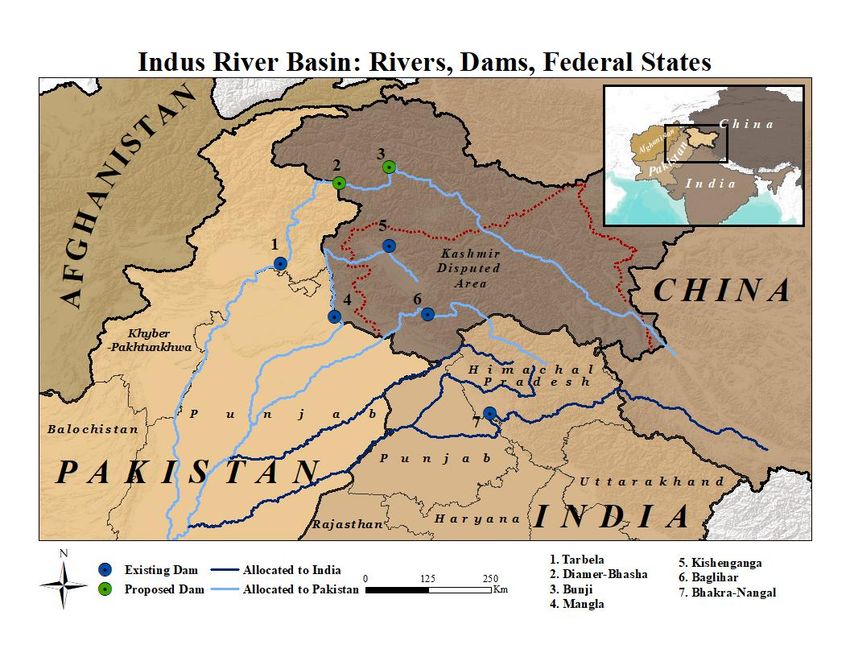
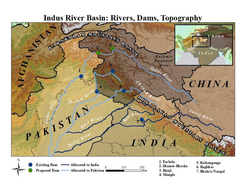
The Kashmir Dispute

Disputes involving the territory of Kashmir (which lies in the Indus River Basin) have been the proximate
cause of three of the four wars fought between the neighbors. The dispute is complicated by the presence
of a third claimant – China. Kashmir is currently partitioned between the three (Figure 1).

FIGURE 1: Kashmir’s zones of control by India, Pakistan and China. Map generated using ArcGIS®
software by ESRI.

India and Pakistan view Kashmir differently. Whereas India has traditionally seen the issue as primarily
that of terrorism fueled by the Pakistani state, achieving control over all of Kashmir has been a key
strategic goal of Pakistan since independence. However, Indian-held Kashmir was mainly peaceful
(except during wartime) till 1989, when growing unrest among in the wake of an allegedly rigged state
election escalated into a violent campaign against the Indian state. Kashmiri militants sought to either
merge the region with Pakistan or achieve independence from both countries. Over time, the pro-Pakistan
and radical Islamist groups have come to dominate the militancy.

The intensity of Kashmiri militancy is prone to cycles. The 1990s were a particularly violent year
culminating in the Kargil war high in the Himalayas in the summer of 1999. This was followed by an
eyeball-to-eyeball confrontation between the two countries in 2001-02 with more than a million troops
mobilized on the border for a full-scale war.

After a significant thaw and formal ceasefire in the wake of these crises, during which a lasting settlement
on Kashmir seemed plausible, militancy began to increase again. One particular attack in November of
2008 stood out both for its intensity and its by unusual reach as far as the Indian financial capital of

                                                                                                          3
BRIEFER No. 4 | January 23, 2020                                  The Council on Strategic Risks
Mumbai, located 2000 km from Kashmir. The horrific attack unfolded over three days and killed 166
people, including six Americans, in railways stations and hotels across the business district of the giant
metropolis. The Mumbai attack effectively ended the peace process between New Delhi and Islamabad.
Kashmiri militants struck most recently in February, 2019 when a suicide bomb attack killed 40 Indian
troops near Pulwama in Kashmir. The Pulwama terror attack led to a major armed clash between the two
countries involving aerial dogfights and a missile strike by India on an alleged terror camp in Balakot,
deep inside Pakistani territory. Since then, tensions have been high on the Kashmir border with frequent
exchanges of artillery fire and casualties on both sides. A few months after this incident, the Indian
government abolished the state of Kashmir’s autonomous status and additionally partitioned and demoted
it to two centrally-controlled territories, further escalating tensions in the region.
India has long alleged Pakistani arming and training for Kashmiri militant groups – an allegation that
gained international credibility after strong evidence linked the Mumbai terrorist attack to the Pakistan-
based group Lashkar-e-Tayyiba (LeT). LeT has been classified as a Foreign Terrorist Organization by the
US state department. Pakistan however has denied it provides anything more than diplomatic and moral
support for what it considers to be a freedom struggle of the Kashmiri people against Indian occupation.
Escalatory Pathways to Nuclear Use
Although conventional warfare itself between India and Pakistan could be enormously destructive for
both countries, it is nuclear escalation that has truly existential potential, not just for the subcontinent, but
also for the wider region and even the world (Parthemore, 2019; Toon et al., 2019). In studying past crises
under the nuclear shadow, scholars have vigorously debated the efficacy of various factors including
nuclear deterrence and the role of US mediation in preventing escalation to full-blown war (Kapur 2007,
2008; Mistry, 2009; Lavoy, 2009; Nayak and Krepon, 2012; Ganguly and Hagerty, 2005; Ganguly and
Kapur, 2010). Scholars have also examined deeper historical factors such as strategic culture in
explaining India and Pakistan’s nuclear behavior (Basrur, 2001; Shidore, 2015; Rais, 2015).
Escalatory scenarios of the rivalry most commonly begin with a terrorist attack in Kashmir or mainland
India attributed to Pakistan by New Delhi and a retaliatory conventional strike by Indian troops. However,
a terror attack is not the only potential trigger for escalation in South Asia. Enhanced firing across the
border could take on a life of its own and potentially escalate to cross-border strikes. Recent exchanges in
Kashmir have involved heavier weapons and much more artillery fire than before. Since the Balakot air
strike it is also feasible that the next crisis will be triggered by a pro-active Indian operation to seize
territory in Pakistani-held Kashmir (Dalton & Kalwani, 2019).
The next section will analyze the impact of climate change on the Indus river basin.
THE INDUS RIVER BASIN AND CLIMATE CHANGE
The Indus River Basin
One of Asia’s largest river systems, the Indus River Basin (IRB) consists of the key artery, the Indus
river, and a number of tributaries, most of which are major rivers in their own right (figure 2). These
include the Jhelum, Chenab, Ravi, Sutlej, and Beas rivers. Together these six rivers carry approximately
0.2 billion cubic meters of water annually. The IRB rivers originate in the Himalayas, the Karakoram, and
the western end of the vast Tibetan plateau. This region has been dubbed the “third pole” as it contains the
greatest amount of frozen freshwater next to the north and south poles. Glaciers in the third pole form a
key source of flows in the IRB.
The Indus originates in Tibet and flows along the Karakoram mountain range before entering the plains of
Pakistan and emptying into the Arabian Sea. The Sutlej too originates in Tibet and passes through the
Himalayas before entering the plains. The other four rivers begin in Indian territory in the Himalayas
4
BRIEFER No. 4 | January 23, 2020 The Council on Strategic Risks(figure 2). Under the terms of the Indus Waters Treaty (see below), three western rivers (Indus, Jhelum,
Chenab) have been allocated to Pakistan, while India has the rights to the waters of the three eastern
rivers (Ravi, Beas, and Sutlej).
FIGURE 2: The Indus River Basin and its key dams. Map generated using ArcGIS® software by ESRI.
The IRB is the world’s largest irrigated area from a single river system, with 26 million acres under
cultivation in India and Pakistan. It is much more central to Pakistan’s economy than India’s, as 80% of
Pakistan’s agricultural output lies within the IRB. The IRB is also key to livelihoods and water supply in
northwestern India, in the states of Punjab, Haryana, Rajasthan, and centrally-administered territories of
Jammu and Kashmir and Ladakh, with inter-state disputes on water sharing a complicating factor (figure
3; also see Box 2). Hydroelectric projects in the IRB are important to both countries, but particularly to
Pakistan’s energy needs.
5
BRIEFER No. 4 | January 23, 2020 The Council on Strategic RisksFIGURE 3: The Indus River Basin with adjacent federal states within India and Pakistan displayed. Map
generated using ArcGIS® software by ESRI.
Two major precipitation cycles nourish the IRB – Western Disturbances (WD) from December to March,
and then again with lesser frequency in the pre-monsoon season and the Indian monsoon from June to
September. The Indus and Jhelum basins primarily receive precipitation from WD while Ravi, Sutlej, and
Beas from the monsoon. Chenab is about evenly split (figure 4).
Precipitation flows into the rivers in three ways – runoff from rainfall, snowmelt, and glacier melt
(Savoskul and Smakhtin, 2013). While rainfall runoff is close to immediate, snowmelt and glacier melt
occur later when temperatures rise with the ebbing of winter. Thus, the latter two provide the means for
maintaining river flows through the spring and summer. Snowmelt tends to peak in spring while glacier
melt in late summer. An estimated 31% of net IRB flow originates from glacier and snow melts, almost
evenly distributed between the two (Savoskul and Smakhtin, 2013, 25). This fraction is greater for the
western rivers as compared to the eastern rivers.
6
BRIEFER No. 4 | January 23, 2020 The Council on Strategic RisksFIGURE 4: Precipitation for Indus basin rivers up to the India border by source. Winter and pre-
monsoon precipitation is from Western Disturbances while summer precipitation is from the
subcontinent’s Summer Monsoon. Source – Author from data in (Deshpande and Kulkarni, 2015).
Climate Impacts on IRB
Scientists have demonstrated that climate change is already impacting the IRB. Increased rainfall and
increased concentrated precipitation events over western Himalayas have been shown to be caused due to
climate change (Krishnan and Sabin, 2019).
Observations for glaciers within the IRB however show major local variations. Glaciers in the Karakoram
mountain range (in the northernmost portions of Kashmir) are stable or increasing, as the net rainfall due
to WD in these regions is actually increasing (Krishnan and Sabin, 2019; Muhammad et al., 2019). This
unusual behavior is known as the “Karakoram Anomaly,” and mostly affects the Indus river. However,
glaciers in the western Himalayas through which most of the IRB rivers pass through or originate, are
shrinking at a substantial rate, which is mostly relevant to the other five rivers.
Scientists have also attempted to forecast climate trends on the subcontinent generally and the IRB
specifically up to the next few decades, as reported in the most recent (i.e. fifth) assessment report from
the Intergovernmental Panel on Climate Change (IPCC), the global body that assembles and publishes
scientific climate projections on a periodic basis. The complexity of climate phenomena means that these
forecasts inevitably come with uncertainties.
The main climate phenomenon in the region is the Indian monsoon. For India as a whole, the IPCC
projects increased interannual variability, extreme rainfall incidents as also longer monsoon duration
(IPCC, 2013a, 1229-1232, 1272-1273).3 The IPCC projects increasing mean precipitation for the
monsoon, but model results have large associated uncertainties4(IPCC, 2013b, Figure A1:63).
3 Since the IPCC AR5 was published in 2014, modeling accuracy for the Indian monsoon at local scales has not
advanced significantly. However, the first results from more accurate, low-resolution models will be published in
2020 and are likely to provide a better understanding of localized trends.
4 The Clausius-Clapeyron equation in climate science yields a roughly 7% increase in water vapor per 1 C of
warming.
7
BRIEFER No. 4 | January 23, 2020 The Council on Strategic RisksObserved data however shows that mean rainfall has actually been decreasing in many parts of India since
the 1950s (Koll and Ghosh, 2017), though this is likely due to some combination of the well-established
60-year cycle of monsoon variation, effects of air pollution, and land use changes. There is much greater
certainty that we will see greater intensity of rainfall in the future.
Forecasts specifically for the IRB region are of greatest relevance to the India-Pakistan question. The
entire IRB is projected to have bursts of rainfall with greater intensity and smaller area of coverage due to
climate change, according to a climate model simulation (Deshpande and Kulkarni, 2015). Simulations
also suggest that the intensification of the WD activity and enhanced precipitation over the Karakoram is
likely to continue several decades into the future. On balance, it would be reasonable to assume that mean
precipitation in the IRB is unlikely to decrease in the longer run, and the intensity of precipitation events
is likely to increase.
Glacier melt is an important contributor to IRB flows. The most recent study of glacier trends in the IRB
forecasts stable glacier mass associated with the (Pakistani-allocated) western rivers, especially the Indus
river, for most of the century, but much faster glacier loss for the (Indian-allocated) eastern rivers. Glacier
melt runoffs will decrease sharply after 2050 for the Sutlej, for instance (Prasad et al., 2019, Figure 5).
The shrinkage of glaciers for the eastern rivers will not reduce mean annual flows (if anything, increasing
them in the shorter run), but will make them much more seasonal and uneven. This increased volatility
will be further compounded by increasing extreme precipitation events and glacial lake outburst floods
(below). Snowmelt will also happen earlier in the year and glacier melt will initially increase and then
decrease for the eastern rivers. (Jeelani et al., 2012; Hasson et al., 2017).
FIGURE 5: Glacier melt for the Sutlej river through the 21st century. Source – Prasad et al., 2019
In case of the western rivers, flow from glacier melts will likely increase till about 2070 and then begin to
slowly decrease. For the Indus river specifically (which is mainly fed by glacier and snowmelt up to the
Indian border), net flow is likely to be relatively the same or increasing till late in the 21st century, due to
the Karakoram Anomaly.
Glacial Lake Outburst Floods (GLOF) are other phenomena that climate change will worsen. These
floods are triggered by the collapse of a lake formed within a glacier, causing a sudden outburst of water.
Faster melting glaciers make such lakes more vulnerable to collapse. A recent study has detected
thousands of such lakes at risk of collapse in the Himalayan region (Yirki, 2019).
8
BRIEFER No. 4 | January 23, 2020 The Council on Strategic RisksThe take-away from the science therefore is that mean flows in the rivers of the IRB are likely to increase
until at least the middle of the century. However, these flows will become much more volatile and
seasonal, especially in the cases of the three eastern rivers allocated to India.
The principal climate risk in the IRB therefore is the increasing frequency and intensity of flood and flash
flood events. Spring is likely to be a flood-prone season. More intense rainfall and GLOFs will likely lead
to increased summer flooding as well, though after 2050 reduced glacier melt flows could also imply
more drought events in the summer in eastern rivers. Some of the flooding events in the IRB will very
likely be severe, exceeding past cases such as the “super-flood” of 2010 in Pakistan which was partly
attributable to climate change (Gronewald, 2010, Asian Development Bank, 2013).
THE INDUS WATERS TREATY
The partition of the subcontinent also divided the IRB between India and Pakistan, leading to bilateral
disputes after 1947 over sharing its waters (including contestations between federal states – see Box 1).
After several rounds of World Bank-facilitated negotiations, the two governments signed the landmark
Indus Waters Treaty (IWT) in 1960 (World Bank, 1960).
BOX 1: Subnational Complications
Though international water disputes often get the most attention, the more intense
water conflicts in the world tend to take place at local and subnational levels
(Conca, 2012). Prior to 1947, there were major disputes over sharing the Indus
River Basin between colonial states of Punjab, Sindh, Bahawalpur, and Bikaner, in
spite of all of them being ruled or dominated by Britain. In more recent decades,
bitter disputes between the Indian states of Punjab, Haryana and Rajasthan over
sharing waters of the Sutlej and Beas rivers (figure 3) was one driver behind the
separatist Sikh insurgency which wracked Punjab in the 1980s.
There has long been anger in Indian-held Kashmir at perceived diversion of the
state’s hydroelectricity to other parts of India, as only 12% of the generation is
allocated to state residents (Dar, 2013). In Pakistan a major dispute between Punjab
state and the states of Sindh and Khyber-Pakhtunkhwa has for decades stalled the
construction of the proposed Kalabagh dam on the Indus river.
Farther afield from the IRB, the peninsular Indian states of Tamil Nadu and
Karnataka regularly battle over the use of Cauvery river waters. The Cauvery
however is only one of several unresolved river water disputes within India. A
number of tribunals have adjudicated some of these disputes, but others remain in
litigation. In extreme circumstances, there is the potential of subnational river basin
disputes contributing to outright separatism, as the case of Indian Punjab in the
1980s demonstrates.
Structure of the Treaty
The IWT partitioned the six main rivers of the system such that Pakistan received the rights to the waters
of the three western rivers Indus, Jhelum (known as Neelum in Pakistan), and Chenab, while India was
awarded unrestricted rights of three eastern rivers Ravi, Beas, and Sutlej (figure 3). Overall, Pakistan was
awarded 133 MAF, or 80% of the IRB waters, with India getting 33 MAF, or 20%.5 (Although the Indus
5 MAF = Million Acre Feet, a unit of water volume commonly used in assessing river flows.
9
BRIEFER No. 4 | January 23, 2020 The Council on Strategic Risksand Sutlej rivers also flow through China (Tibet), Beijing was not a party to the treaty and remains
outside its purview – see Box 2.)
The IWT consisted of detailed clauses defining permissions and constraints on the use of these waters by
each country. For example, India is allowed to use the waters of the western rivers (allotted to Pakistan)
for “non-consumptive purposes” such as hydroelectric generation, navigation, and a limited amount of
irrigation as well as limited storage to the extent of 3.6 MAF.
A dispute settlement mechanism is also provided in the treaty. A Permanent Indus Commission (PIC)
consisting of a commissioner each from India and Pakistan is mandated to meet at least once a year, and
inspect desired river sites every five years. The PIC is the first stop for the raising and resolution of any
differences between the parties. If the PIC cannot resolve a dispute, it can be referred to a Court of
Arbitration. If the dispute is however technical in nature, a World Bank-appointed “Neutral Expert” is to
adjudicate the matter. Verdicts are binding on both parties.
Multiple Disputes
Unsurprisingly, almost all objections within the IWT have been raised by Pakistan, the downstream
country, against Indian upstream projects. Negotiations within the PIC itself have resolved several of
these questions in the past, such as over India’s Dulhasti and Salal dams (Water Power & Dam
Construction, 2007). Two items however were escalated beyond the PIC’s ambit, namely the 900 MW
Baglihar and 330 MW Kishanganga hydroelectric projects on the Chenab and a tributary of the Jhelum
river respectively. The resultant rulings, in 2007 and 2013 respectively, are seen as landmarks in
international water law.
In Baglihar, a key Pakistani objection was the positioning of gated spillways in the dam well below its
‘Dead Storage Level’ (DSL) for ‘drawdown flushing’ (a method for de-silting), which it feared would
allow India to manipulate flow downstream (Hussain, 2007; Water & Power Magazine, 2017) to create
floods or droughts in its territory. In Kishanganga, Pakistan argued that diversion of waters from one
Indus tributary to another was not allowed under the IWT and water levels in the planned reservoir could
not fall below the Dead Storage Level (DSL), which India planned to do for de-silting purposes.
The technical ruling by a ‘Neutral Expert’ went mostly in India’s favor in the Baglihar case. The
Kishenganga case was adjudicated by a Court of Arbitration and therefore took up deeper questions of
interpretations of the treaty. The ruling largely favored India on the question of water diversion. But
drawdown flushing by reducing water levels below the DSL was disallowed. This meant that the Baglihar
ruling’s allowance of this technique was not accepted as a general principle - a setback for New Delhi.
The survival of the IWT through four wars by these bitter rivals, and the fact that the two parties could
avail of and essentially abide by the dispute resolution processes specified in the treaty can be taken as a
sign of the strength of the IWT. However, Baglihar and Kishanganga are by no means the only disputes in
the IRB; Pakistan has also objected to several other dams (see below). Continuing terrorist attacks and
India’s recent demotion of Kashmir’s status in the Indian federal structure has further raised tensions
between the neighbors. The future survivability of the IWT under these circumstances is now a legitimate
question.
10
BRIEFER No. 4 | January 23, 2020 The Council on Strategic RisksBOX 2: The China Factor
Though China is not usually in the news on IRB disputes, the rivers Sutlej and Indus
originate deep within Tibet. China is also the key upstream actor when it comes to the
Brahmaputra River Basin (BRB) in the far east of India. India has a data sharing
agreement on these rivers with China (Economic Times, 2018a), but retains a fear of
possible water diversion projects Beijing may undertake on the river. China has also been
a close security partner of Pakistan for decades.
Chinese diversion of IRB waters is unlikely, due to the vast distances separating the basin
from demand centers nearer to the coast. It is more logical for China to undertake such
projects for rivers such as Brahmaputra in eastern Tibet. However, joint Chinese-Pakistani
strategies on dam building have intensified of late raising concern in New Delhi (Grover,
2017). China has agreed to assist Pakistan in the construction of a cascade of five major
dams on the upper Indus river in Pakistani-held Kashmir and the Pakistani province of
Khyber-Pakhtunkhwa as a part of Beijing’s Belt and Road Initiative (BRI). The five
dams, namely Diamer Bhasha, Patan, Thakot, Bunji, and Dasu (Sehgal, 2019) are slated to
have a net power generation capacity of 22 GW. Pakistan however subsequently rejected a
Chinese role in the Diamer-Bhasha dam (Chaudhary, 2018).
The projects remain in their early stages, with only Diamer-Bhasha and Dasu moving
forward (Abbas, 2019). Still, the potential entry of China in such a consequential manner
in a territory claimed by India has raised major concerns in New Delhi (Singh, 2017).
India objects to some of these projects principally on grounds of sovereignty rather than
water security, though it could in principle raise objections to some of them under the
redressal mechanisms of the IWT.
WILL THE INDUS WATERS TREATY SURVIVE?
Water emerged as a major issue in the India-Pakistan dynamic after many decades when Pakistani
militant and Lashkar-e-Taiba leader (as well as the alleged mastermind of the 2008 terrorist attack on
Mumbai) Hafiz Saeed began accusing India of using water as a tool of hostility back in 2010 (Economic
Times, 2010).
However, the role of water acquired a new prominence in the wake of a terrorist attack by alleged
Pakistani-backed militants on an Indian army camp in Uri, Kashmir in September 2016. “Blood and water
cannot flow together at the same time,” Indian Prime Minister Modi famously said in a reaction to the
attack, implying tough Indian action on Indus waters.
Indian water resources minister Nitin Gadkari reiterated this sentiment in the wake of the Pulwama attack
in February 2019, tweeting that India had “decided to stop our share of water which used to flow to
Pakistan.”6 India set up a high-level task force was set up under the stewardship of the Principal Secretary
to the Prime Minister to ensure that India makes full use of the waters it is entitled to under the Treaty”
(Indian Express, 2019). Pakistan’s responses were equally bellicose, warning that any such move would
be taken as an “act of war” (Jorgic and Wilkes, 2016).
6 https://twitter.com/nitin_gadkari/status/1098567044574916608
11
BRIEFER No. 4 | January 23, 2020 The Council on Strategic RisksClimate Complications
The effects of climate change act to magnify growing stresses on the IWT. Though net flows in the rivers
are not yet affected and are unlikely to reduce due to climate change, they will almost certainly become
more volatile.
Thus, flooding events will very likely increase in the IRB (see above). Pakistan’s darkest fears are that
India will manipulate dam storage levels to magnify downstream floods, hurting Pakistani farmers badly.
However, any such moves by India will also adversely affect inhabitants in Indian-held Kashmir that
reside downstream of the dams. India on the other hand worries that Pakistan will use floods caused in
part due to climate change to falsely accuse India of water manipulation to score geopolitical points.
Due to the younger geology of the Himalayas, the Indus basin rivers suffer from a problem of silt, which
builds up behind dams over time, greatly reducing their efficacy. Large Pakistani dams in the IRB such as
Mangla and Tarbela already suffer from a major silt problem. Deforestation, partly due to climate change,
is only increasing silt load, particularly in the Jhelum and Chenab rivers (Asian Development Bank,
2013). These are precisely the rivers on which Indian projects are the most contested by Pakistan.
The growing silt load puts pressure on India for embracing dam designs that can combat silt. Designs that
allow flushing well below DSL also allow for greater flow manipulation. The ‘dual use’ nature of these
designs has the effect of making Indian intent difficult to gauge from the Pakistani standpoint, and
Pakistani attempts to scuttle Indian projects easier from the Indian standpoint. Given a general
environment of a massive lack of trust between India and Pakistan, climate complications are only
deepening distrust and raising tensions over the IWT.
India’s Options
Since 2016, there has been much speculation in the Indian and Pakistani media on a unilateral Indian
pullout from the IWT. Rhetoric aside however, what are India’s realistic options with respect to the IWT
as climate impacts grow, and how might Pakistan react?
In principle, India has two ways of hurting Pakistan over water. The first is, as Indian official Gadkari
said, to ensure that it uses all the water of the eastern rivers for consumptive purposes, so that almost none
flows into Pakistan. This is allowed under the IWT.
However, India already uses more than 95% of the eastern rivers’ water through dams it has built over the
decades such as the giant Bhakra-Nangal project (Patel, 2019). Only about 1 MAF currently flows into
Pakistan (Hasnain, 2019). Announced projects such as Shahpur Kandi will mop up most of the trickle that
does flow across the border. In any case, Pakistan does not object to these moves (Hasnain, 2019), so
there’s little chance they will raise bilateral tensions.
The second option is to prevent more of the water in the western rivers (allocated to Pakistan) from
flowing across the border. This can be done through diversion and/or building large dams in Kashmir.
Diversion is extremely difficult given the formidable terrain in the region.7 The cost and engineering
challenges are prohibitive, especially so for the financially constrained Indian state and is therefore
practically ruled out. Diversion of this magnitude would also be a clear treaty violation.
Building more storage on western rivers is a more realistic option for weaponizing water. In theory a large
enough storage volume will allow India to manipulate flows in the western rivers, blocking them during
7 There is however a smaller diversion project currently being constructed by India and opposed by Pakistan, the
Tulbul navigation/Wullar barrage project on the Jhelum river, which also includes a storage facility. This specific
project however seems sanctioned by the treaty (Annexure D, para 16) which allows such a diversion on the Jhelum
river. The clause was added in the treaty as India had already planned the project during its drafting stage.
12
BRIEFER No. 4 | January 23, 2020 The Council on Strategic Risksthe dry season and releasing extra water during the wet season making downstream Pakistan prone to
greater droughts and floods. But India’s existing major dams on the western rivers (Kishenganga,
Baglihar, Salal, and Dul Hasti) are run-of-the river types, which involve minimum storage India has
utilized only 0.5 MAF of the 3.6 MAF of storage allowed so far (Grover, 2019).
There is therefore scope for expanding storage on the western rivers. Planned Indian dams such as Bursar,
Pakal Dul, Ratle, Lower Kalnai, Jispa, and Sawalkot have raised major concerns in Pakistan on this score
(Waqar, 2019). India views these dams as staying within its storage obligations. Pakistan disagrees and is
especially concerned about the cumulative storage magnitude on the Chenab river. Pakistan may invoke
the dispute resolution process on Pakal Dul and Lower Kalnai projects, as PIC-level talks have
deadlocked (Economic Times, 2018b).
Any Indian attempt to breach storage limits allowed under the IWT will be taken to arbitration by
Pakistan and likely ruled illegal. Also, the Kishenganga ruling by the Court of Arbitration did not
generalize the earlier Baglihar ruling on allowing drawdown flushing below DSL. This limits India’s
legal pathway to reproduce the Baglihar design for its future dams, thereby constraining manipulation-
prone storage. Then there is the question of who will use all the extra stored water during peacetime -
demand for irrigation has actually gone down over the years in Indian-held Kashmir as many farmers
have switched to horticulture (Sinha, 2019).
Pakistan believes India’s strategy is to present it with a fait accompli of completed projects before any
legal process concludes. But building these dams will also take India a long time – at least a decade or
two in spite of a renewed push for construction (Sen, 2019). State-owned NHPC, tasked with the
construction, has a track record of delays across India. Thus, and Pakistan has plenty of time to raise
objections at each stage. Local protests by affected villagers against several of these dams are likely to
snarl the projects further (The Wire, 2019; The Tribune, 2017). There has long been deep resentment in
Indian-held Kashmir on the Indian government’s perceived diversion of a large majority of generated
hydropower outside the territory (Dar, 2013).
Unilateral Indian Abrogation?
As the downstream party, it is clearly not in Pakistan’s interest to formally pull out of the IWT, but rather
raise as many objections as possible within the treaty mechanism to slow down or halt Indian projects. If
bilateral tensions continue to grow however, is it conceivable that India could openly flout or even
abrogate the treaty unilaterally?
The IWT (Article XII) does not provide for unilateral abrogation by either party. Thus, any abrogation by
India without the express consent of Pakistan will be in material breach of the IWT. The Vienna
Convention on the Law of Treaties (VCLT) (UN, 1969), allows for a unilateral exit under Article 46 if a
state can show that a treaty is in contradiction with an internal law of fundamental importance. However,
it will be difficult for India to make this case given that it has accepted and operationalized the treaty for
nearly six decades without invoking this argument.8
The political costs of unilateral abrogation would also be steep as much of the international community
will likely oppose any such Indian move. This fact coupled with the relatively limited material gains India
can make even if freed from the treaty’s constraints makes it unlikely that New Delhi will choose
unilateral abrogation as a strategy.
However, this conclusion comes with two caveats. One is the tolerance for high risk in India’s post-2016
Pakistan policy, which has brought withdrawal from the IWT within the bounds of plausibility. The
second is a still-unlikely scenario of a general breakdown of core norms of the global order, which would
8Although India is not a signatory to the VCLT, its wide global acceptance means that it has emerged as a global
norm. Besides, Indian courts have cited the VCLT in some of their rulings, lending it legitimacy within India.
13
BRIEFER No. 4 | January 23, 2020 The Council on Strategic Risksmake an Indian abrogation much easier.
Pakistan’s Options
Pakistan’s approach has relied on utilizing the IWT-mandated process to raise its objections and, in the
cases of Baglihar and Kishenganga, take India through a judicial process. From India’s standpoint,
Pakistan raises objections at every stage to stall projects on western rivers. Pakistan also uses India as an
excuse to divert attention from its own major failures on water management - being on track to reach high
levels of water scarcity as early as 2025, well before India (Kugelman & Hathaway, 2009).
But Pakistan also has kinetic options of interfering with Indian dam construction through inciting attacks
by Kashmiri militant groups, which Islamabad has a long track record of supporting. There has been at
least one case of such an attack during the early stages of the Kashmir militancy. Indian projects could
also be targets for any direct hostilities that may take place on the Kashmir border between the two
armies, a scenario more likely now in the wake of the February 2019 clashes. The faster India completes
its projects, the more target-rich environment is the result for Pakistan and its proxies.
However, increased militant attacks in Kashmir carry major risks for Islamabad if they can be shown to
have their origins in Pakistan, which now includes the plausibility of an Indian counter-strike. India’s
Balakot air attack was a strategic surprise for many in the Pakistani military. The Modi government has
clearly shown an unprecedented will to take risks when it comes to Pakistan.
CONCLUSION: CLIMATE, WATER AND SUBCONTINENTAL CONFLICT
The relationships between climate change and conflict are complex and case-specific (Busby, 2019; Tir
and Stinneett, 2012; Risi, 2019, Wolf et al., 2003).The use of water as one weapon in an armed conflict
determined by other factors has been recorded many times. For example, Turkey halted water flow from
Euphrates to Syria in April-May 2014, when it was allegedly arming factions opposed to the Syrian
government. Israel has also cut freshwater supplies to the Gaza strip on several occasions. The IRB itself
has experienced such an event when India cut-off water in some of the rivers flowing to Pakistan in 1948
during an ongoing war between the two over Kashmir.
Climate impacts are having their greatest impact on the IRB in terms of variability and volatility of river
flows. Variability rather than scarcity is also a better indicator of conflicts over water, as existing
practices and institutions have a harder time coping with higher levels of unpredictability (Risi, 2019).
Thus, while water wars may not be our future, water as a tool of coercive diplomacy may become more
frequent (Conca, 2012).
The IWT, designed six decades ago (well before the modern environmental movement emerged), is
simply inadequate to manage the growing environmental and demographic challenges it is being
subjected to over time. A core problem is that the treaty is a partition agreement, not an integrated water
management pact. In a sense it is a logical continuation of the partition of the subcontinent.
But while territory may be divided definitively, dividing a flowing, dynamic resource such as water
increasingly subject to the vagaries of climate change is much more challenging. In fact, the IRB
encompasses not just India and Pakistan but also China (see box) and Afghanistan. Ideally all four
countries ought to evolve a joint approach to basin management. This could include electricity trade, joint
flood control and disaster management, and coordination on climate adaption projects.
Very few instances of cooperation of this sort have occurred. Indian and Pakistani militaries sometimes
aid each other during disasters such as avalanches. India, Pakistan, and China have recently launched an
initiative on climate cooperation on western Himalayas (Koshy, 2019), a first such tri-nation initiative.
But these steps fall far short of what is needed.
14
BRIEFER No. 4 | January 23, 2020 The Council on Strategic RisksThe most likely conflict trigger linked to climate change is a natural calamity in the IRB. This could
involve a major flooding event triggering release of waters by upstream dams in Indian-held Kashmir.
Pakistani allegations of deliberate Indian manipulation of such an event to magnify damage, whether true
or not, may lead to an armed clash.9
But ultimately, water and climate change are magnifying factors for what are at their root historical,
ideological and territorial tensions in the India-Pakistan rivalry. By themselves, water tends to induce
cooperation more than conflict, but if refracted through the prism of variability and uncertainty induced
by climate change and existing deep political-ideological hostilities, it may increase chances of armed
conflict.
Current geopolitical trends in the region indicate that India and Pakistan are on a collision course. The
trigger for any serious outbreak of armed conflict is likely to be terrorist attack or a border clash in
Indian-held Kashmir. Targets of any terrorist strike could be military or civilian, including expanding
Indian hydropower projects. Climate change is unlikely to be the proximate cause for an escalation
between the subcontinental neighbors. Rather, increased stress on the IWT, partly climate-induced,
magnifies the already-present risk of armed conflict and makes it more likely.
In the worst-case scenario, such a conflict may turn nuclear. Nuclear deterrence, which has been a major
factor in preventing large-scale warfare in South Asia since the two nations went nuclear in 1998, is
weakening due to shifts in Indian strategic culture (Shidore, 2015) and a combination of technology
advances and changes in capability on both sides. A nuclear exchange, should it occur, could have major
and devastating effects on the global climate, including a global cooling of 2 to 5 C (Parthemore, 2019;
Toon et al., 2019).
Thus, India and Pakistan face a clear choice. They can view the increasing water and climate crisis as an
opportunity for a whole new level of institutional cooperation that eventually extends to other neighbors.
Or, they can turn inwards and view growing climate and water stress as simply another reason to double
down on their current zero-sum framing of their conflict. The choices they make will be decisive in
determining the subcontinent’s future.
Sarang Shidore is a Senior Fellow at the Council on Strategic Risks and a Senior Research
Analyst at the Lyndon B. Johnson School of Public Affairs at the University of Texas at Austin,
specializing in geopolitical risk and the energy-climate nexus.
The author wishes to acknowledge the assistance of Matthew Preisser in generating the figures.
Maps throughout this document were created using ArcGIS® software by ESRI. ArcGIS® and
ArcMap™ are the intellectual property of ESRI and are used herein under license. Copyright ©
Esri. All rights reserved. For more information about ESRI® software, please visit
www.esri.com.
9 Climate change could also conceivably escalate the India-Pakistan rivalry in more diffuse ways. The increased
frequency of extreme rainfall, enhanced drought, decreased groundwater and river flows in the region more broadly
can deepen distress of the population and stall economic growth. Governments may then be tempted to play up
external rivalries and causes in order to safeguard their domestic legitimacy, which can set in place an escalatory
dynamic. In any such situation climate change would however be only one of many factors involved.
15
BRIEFER No. 4 | January 23, 2020 The Council on Strategic Risks16 BRIEFER No. 4 | January 23, 2020 The Council on Strategic Risks
REFERENCES

Abbas, Hassan (2019), “Diamer Bhasha Dam: Wapda may Award Contract in 6 to 8 Weeks: Chairman,”
Business Recorder, https://www.brecorder.com/2019/12/06/550877/diamer-bhasha-dam-wapda-may-
award-contract-in-6-to-8-weeks-chairman/

Asian Development Bank (2013), “Indus Basin Floods: Mechanisms, Impacts, and Management,”
https://www.adb.org/sites/default/files/publication/30431/indus-basin-floods.pdf

Basrur, Rajesh (2002), “Kargil, Terrorism, and India’s Strategic Shift,” India Review, 1 (4), 39-56.

Basrur, Rajesh (2001), "Nuclear Weapons and Indian Strategic Culture," Journal of Peace Research, vol.
38 no. 2, 181-198.

Busby, Joshua (2019), The Field of Climate and Security: A Scan of the Literature, Social Science
Research Council, https://www.ssrc.org/publications/view/the-field-of-climate-and-security-a-
scan-of-the-literature/

Business Recorder (2019), “Hydropower Projects: PM Given Briefing,”
https://www.brecorder.com/2019/12/27/556748/hydropower-projects-pm-given-briefing/

Chaudhary, Deepanjan Roy (2018), “Pakistan Rejection of China’s Dam Aimed at Showing OBOR in
Line with Global Rules,” Economic Times, https://economictimes.indiatimes.com/news/defence/pakistan-
rejection-of-chinas-dam-aimed-at-showing-obor-in-line-with-global-rules/articleshow/61715963.cms

Conca, Ken (2012) “Decoupling Water and Violent Conflict,” Issues in Science and Technology 29 (1).
Dalton, Toby & Kalwani, Gaurav (2019), “Might India Start the Next South Asia Crisis?” War on the
Rocks, https://warontherocks.com/2019/11/might-india-start-the-next-south-asia-crisis/

Dar, Zubair (2013), “A River and a Turbine,” Seminar, 643, https://www.india-
seminar.com/2013/643/643_zubair_a_dar.htm

Deshpande, N R and Kulkarni, B D (2015), Changing Pattern of Heavy Rainstorms in the Indus Basin of
India under Global Warming Scenarios,” Journal of Earth System Science, 124, (4), 829–841.

Economic Times (2010), “Pak Takes Water Route to Attack India,”
https://economictimes.indiatimes.com/news/politics-and-nation/pak-takes-water-route-to-attack-
india/articleshow/5665516.cms

Economic Times (2018a), “China Begins Sharing Data on Brahmaputra, Sutlej Rivers,”
https://economictimes.indiatimes.com/news/politics-and-nation/china-begins-sharing-data-on-
brahmaputra-sutlej-rivers/articleshow/64527287.cms

Economic Times (2018b), “India Rejects Pakistan's Objections on Two Hydropower Projects,”
https://economictimes.indiatimes.com/news/politics-and-nation/india-rejects-pakistans-objections-on-
two-hydropower-projects/articleshow/65612203.cms

Ganguly, Sumit and Kraig, Michael R. (2005), “The 2001–2002 Indo-Pakistani Crisis: Exposing the
Limits of Coercive Diplomacy,” Security Studies 14 (2), 290–324.

                                                                                                       17
BRIEFER No. 4 | January 23, 2020                                  The Council on Strategic Risks
Ganguly, Sumit and Hagerty, Devin T. (2005), Fearful Symmetry: India and Pakistan in the Shadow of
Nuclear Weapons (Seattle: University of Washington Press)
Ganguly, Sumit and Kapur, S Paul (2010) India, Pakistan, and the Bomb: Debating Nuclear Stability in
South Asia (New Delhi: Penguin Books).
Gronewald, Nathaniel (2010), “Is the Flooding in Pakistan a Climate Change Disaster?,” Scientific
American, https://www.scientificamerican.com/article/is-the-flooding-in-pakist/
Grover, Pramod (2019), “Pakistan’s Water Crisis Not India’s Fault,” The Tribune,
https://www.tribuneindia.com/news/comment/pakistan-s-water-crisis-not-india-s-fault/727048.html
Grover, Pramod (2017), “Dams Pakistan will Build,” The Tribune,
https://www.tribuneindia.com/news/comment/dams-pakistan-will-build/439651.html
Hasnain, Khalid (2019), “Indian blockade of eastern rivers water won’t affect Pakistan,” Dawn,
https://www.dawn.com/news/1469046
Hussain, Masood (2007), “Baglihar Dam: Spillways a Blow to Islamabad,” Economic Times,
https://m.economictimes.com/news/politics-and-nation/baglihar-dam-spillways-a-blow-to-
islamabad/articleshow/1606954.cms
IPCC (2013a), Climate Change 2013: The Physical Science Basis. Contribution of Working Group I to
the Fifth Assessment Report of the Intergovernmental Panel on Climate Change,
https://www.ipcc.ch/report/ar5/wg1/
IPCC (2013b) Annex I: Atlas of Global and Regional Climate Projections. In: Climate Change 2013: The
Physical Science Basis. Contribution of Working Group I to the Fifth Assessment Report of the
Intergovernmental Panel on Climate Change
Jorgic, Drazen and Wilkes, Tommy (2016), “Pakistan Warns of 'Water War' with India if Decades-old
Treaty Violated, Reuters, https://www.reuters.com/article/us-pakistan-india-water-
idUSKCN11X1P1
Kapur, S. Paul (2008), “Ten Years of Nuclear Instability in South Asia,” International Security 33 (2), 71-
93.
Kapur, S. Paul (2007), Dangerous Deterrent: Nuclear Weapons Proliferation and Conflict in South Asia
(Stanford: Stanford University Press)
Koshy, Jacob (2019), “India to Work with China, Pakistan to Gauge Impact of Climate Change,”
https://www.thehindu.com/sci-tech/energy-and-environment/india-to-work-with-china-pakistan-to-gauge-
impact-of-climate-change/article29620759.ece
Kugelman, Michael and Hathaway, Robert (2009), Running on Empty: Pakistan's Water Crisis, Woodrow
Wilson Center, https://www.wilsoncenter.org/publication/running-empty-pakistans-water-crisis
Lavoy, Peter (2009), Asymmetric Warfare in South Asia: The Causes and Consequences of the Kargil
Conflict (Cambridge: Cambridge University Press).
Mistry, Dinshaw (2009), “Tempering Optimism about Nuclear Deterrence in South Asia,” Security
Studies, 18, 148-182.
18
BRIEFER No. 4 | January 23, 2020 The Council on Strategic RisksMuhammad, Sher et al. (2019), “Early Twenty-first Century Glacier Mass Losses in the Indus Basin
Constrained by Density Assumptions,” Journal of Hydrology, 574, 467-475.
Narang, Vipin (2013), “Five Myths about India’s Nuclear Posture,” The Washington Quarterly, Summer
2013, Center for Strategic and International Studies.
Nayak, Polly and Krepon, Michael (2012), The Unfinished Crisis: US Crisis Management after the 2008
Mumbai Attacks (Washington D.C.: Stimson Center).
Parthemore, Christine (2019), “The Human and Climatic Effects of an India-Pakistan Nuclear Conflict,”
Council on Strategic Risks, https://councilonstrategicrisks.org/2019/10/18/the-human-and-climatic-
effects-of-an-india-pakistan-nuclear-conflict/
Patel, Anand (2019), “Only 5 per cent Water from Eastern Rivers Flows into Pakistan: Ex-chairman of
Water Commission,” India Today, https://www.indiatoday.in/india/story/5-per-cent-water-eastern-rivers-
flows-pakistan-ex-chairman-water-commission-1462559-2019-02-22
Prasad, Veena et al. (2019) “Large losses in glacier area and water availability by the end of twenty-first
century under high emission scenario, Satluj basin, Himalaya,” Current Science, 116(10), 1721-1730.
Rais, Rasul Bakhsh (2015), “Pakistan’s Strategic Culture and Deterrence Stability on the Subcontinent,"
in Deterrence Instability and Nuclear Weapons in South Asia (Washington DC: The Stimson Center), 95-
113.
Risi, Lauren (2019), “Beyond Water Wars,” The Wilson Quarterly 43 (3).
Roxy M. K. and S. T. Chaithra (2018), Impacts of Climate Change on the Indian Summer Monsoon. In
Climate Change and Water Resources in India, Vimal Mishra, and J. R. Bhatt, Eds. (New Delhi: Ministry
of Environment Forest and Climate Change), 21-37.
Savoskul, Oxana and Smarthin, Vladimir (2013), Glacier Systems and Seasonal Snow Cover in Six Major
Asian River Basins: Hydrological Role under Changing Climate, Research Report 150, International
Water Management Institute.
Sen, Sesa (2019), “NHPC Lines up Rs 70,000 Crore Investment over 8-9 Years,” New Indian Express,
http://www.newindianexpress.com/business/2019/aug/10/nhpc-lines-up-rs-70000-crore-investment-over-
8-9-years-2016902.html
Shidore, Sarang (2015), "India's Strategic Culture and Deterrence Stability on the Subcontinent," in
Deterrence Instability and Nuclear Weapons in South Asia (Washington DC: The Stimson Center), 119-
148.
Singh, Priyanka (2017), “China-Pakistan Water Axis on the Indus,” Institute for Defense Studies and
Analyses, https://idsa.in/issuebrief/china-pakistan-water-axis-on-the-indus_psingh_190717
Sinha, Amitabh (2019), “Explained: India’s Policy Shift in Sharing Indus Waters with Pakistan,” Indian
Express, https://indianexpress.com/article/explained/the-indus-waters-policy-shift-india-pakistan-
pulwama-attack-5599272/
The Tribune (2017), “Locals Refuse to Allow Jispa Dam Project,”
https://www.tribuneindia.com/news/himachal/locals-refuse-to-allow-jispa-dam-project/438622.html
19
BRIEFER No. 4 | January 23, 2020 The Council on Strategic RisksThe Wire (2018), “Protests Against the Bursar Dam in Jammu and Kashmir Grow Louder,”
https://thewire.in/environment/protests-against-the-bursar-dam-in-jammu-and-kashmir-grow-louder
Tir, Jaroslav and Stinnett, Douglas (2012), “Weathering Climate Change: Can Institutions Mitigate
International Water Conflict?” Journal of Peace Research, 49(1), 211-225.
Toon, Owen et al. (2019) “Rapidly Expanding Nuclear Arsenals in Pakistan and India Portend Regional
and Global Catastrophe,” Science Advances, 5(10).
Waqar, Ali (2018), “Pakistan's concerns over India's hydropower projects remain after opening round of
talks,” https://www.dawn.com/news/1429710
Water & Power Magazine (2017), “Baglihar Decision - An End to the Dispute?”
https://www.waterpowermagazine.com/news/newsbaglihar-decision-an-end-to-the-dispute
World Bank (1960), The Indus Waters Treaty,
https://siteresources.worldbank.org/INTSOUTHASIA/Resources/223497-
1105737253588/IndusWatersTreaty1960.pdf
Yirka, Bob (2019), “Simulations Show Thousands of Lakes in Himalaya Mountains at Risk of Flooding
due to Global Warming,” Phys.org, https://phys.org/news/2019-12-simulations-thousands-lakes-
himalaya-mountains.html
20
BRIEFER No. 4 | January 23, 2020 The Council on Strategic RisksYou can also read