Buildings related datasets accessible through the INSPIRE geoportal
←
→
Page content transcription
If your browser does not render page correctly, please read the page content below

Buildings related datasets accessible
through the INSPIRE geoportal

                    European Union Location
                    Framework (EULF) Project
                    Energy Pilot

                    Giacomo Martirano, Maria Teresa
                    Borzacchiello, Ray Boguslawski, Francesco
                    Pignatelli (JRC H06 Unit), Paolo Zangheri,
                    Daniele Paci, Isabella Maschio, Paolo Bertoldi
                    (JRC F07 Unit)

                    2016

                                                      EUR 28014 EN
This publication is a Technical report by the Joint Research Centre, the European Commission’s in-house science
service. It aims to provide evidence-based scientific support to the European policy-making process. The scientific
output expressed does not imply a policy position of the European Commission. Neither the European
Commission nor any person acting on behalf of the Commission is responsible for the use which might be made
of this publication.

Contact information
Francesco Pignatelli
Address: Joint Research Centre, Via Enrico Fermi 2749, 21027 Ispra (VA), Italy
E-mail: francesco.pignatelli@ec.europa.eu
Tel.: +39 0332 78 6319

JRC Science Hub
https://ec.europa.eu/jrc

JRC102276

EUR 28014 EN

ISBN 978-92-79-59869-2 (PDF)

ISSN 1831-9424 (online)

doi:10.2791/46341 (online)

© European Union, 2016

Reproduction is authorised provided the source is acknowledged.

All images © European Union 2016

How to cite: Martirano G., Borzacchiello M.T., Boguslawski R., Pignatelli F., Zangheri P., Paci D., Maschio I.,
Bertoldi P.; European Union Location Framework - Buildings related datasets accessible through the INSPIRE
geoportal; EUR 28014 EN; doi:10.2791/46341
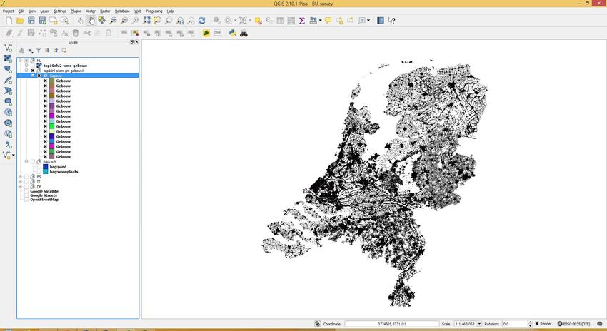
TABLE OF CONTENTS
Abstract ............................................................................................................... 4
1.      Introduction ................................................................................................. 5
2.      INSPIRE context ........................................................................................... 7
  2.1     Relevance of BU (Buildings) datasets ............................................................ 8
  2.2     Fitness of INSPIRE BU data models for energy-related purposes .................... 12
3.      Methodology .............................................................................................. 15
4.      Summary of the findings .............................................................................. 19
5.      Analysis of the inspected datasets in a GIS environment .................................. 30
6.      Conclusions ................................................................................................ 37
References ......................................................................................................... 39
List of abbreviations and definitions ....................................................................... 40
List of figures...................................................................................................... 41
List of tables ....................................................................................................... 42

                                                            3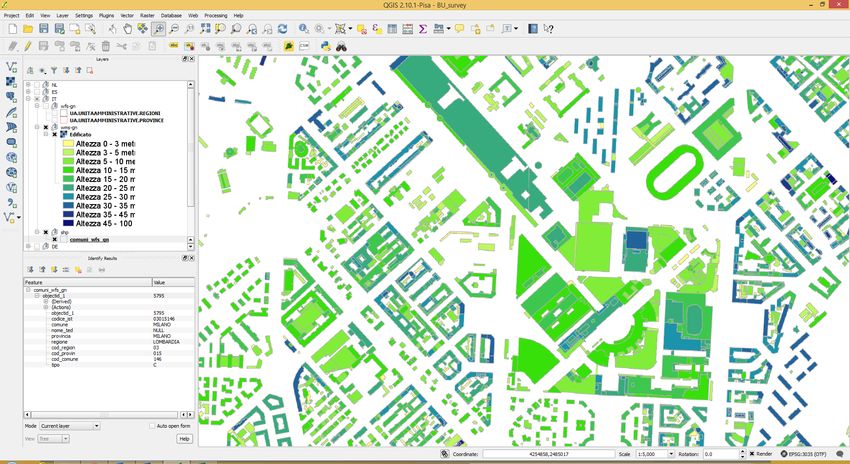
Abstract
The European Union is giving more and more emphasis to its energy policy, whose
strategy and actions are included in the Energy Union Package and the 2030 Framework
for Climate and Energy. Buildings in which people live and work are responsible for an
important portion of the energy consumption in Europe and there are a series of policies
and initiatives that are aiming at improving their energy performances and to collect
data of sufficient quality on the effect of energy efficiency policies on building stock
across Europe. A related initiative is the EC INSPIRE Directive establishing an
Infrastructure for Spatial Information in the European Community [1], addressing a
number of data themes, including buildings. This report aims to assess the extent to
which the buildings-related datasets which European Member States are sharing
following INSPIRE provisions are of good quality and can serve the purposes of the
initiatives related to energy efficiency of buildings. A step by step methodology has been
applied and documented to guide the reader through the discovery of building-related
datasets in the INSPIRE geoportal, focusing primarily on datasets usability in a GIS
environment. A first finding is the high number of building related datasets discovered
through the INSPIRE Geoportal, which confirms its importance as a source of data for
energy efficiency initiatives. Given the several hundreds of datasets discovered, a
sampling mechanism to select a small number of datasets to be further inspected has
been adopted. Following a more detailed analysis, in particular on datasets that can be
downloaded from the Geoportal, we can conclude that some of them are of good quality,
in terms of data accuracy and national geographic coverage, while for others these
criteria are not fulfilled. This can be related to the fact that the INSPIRE roadmap
foresees the full implementation of the Directive in Member States by 2020, so there is
the need to wait that date to exploit the full potential which we are starting to see in
countries that are already advanced in the implementation for historic and cultural
reasons. Moreover, this work has been useful also to identify some recommendations to
INSPIRE implementers working in energy thematic communities, in order to better
address their efforts in fulfilling on-going and future INSPIRE obligations.

                                            4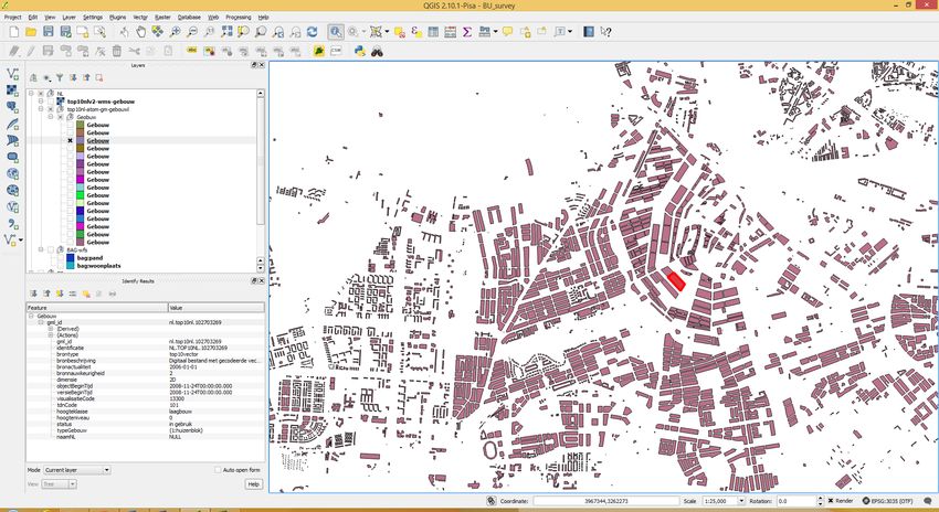
1. Introduction
Buildings are responsible for approximately 40% of the primary energy consumption in
Europe and the Energy Union package calls for “creating the right framework to deliver
energy efficiency in buildings”, implementing concrete measures such as the review of
the Energy Performance of Buildings and Energy Efficiency Directives. However, there is
a lack of quality data regarding the effect of energy efficiency policies on building stock
across European Member States. Such data would give the possibility to base the
interventions on building renovations towards improving their energy efficiency on solid
evidence.
To address this issue, the European Commission (DG Energy) is developing a Building
Stock Observatory which will be a key open access resource in providing comprehensive
information about buildings for decision making (at EU level, but most importantly for
national/local authorities), industry and investors. The Observatory should profit from
relevant information on the energy performance of buildings and related key policies
arising from on-going initiatives, both inside and outside the Commission, involving data
collection, analysis and modelling. The launch of the first version of the EU Building
Stock Observatory is expected in September 2016.
The JRC is supporting the purpose of the Observatory, producing an inventory of
relevant information and data on buildings at Member States level.
In parallel, JRC is leading the EULF (European Union Location Framework 1 ) project,
which is part of the Interoperability Solutions for Public Administrations (ISA)
Programme 2 , run by DG Informatics (DIGIT). The EULF is a framework of
recommendations, guidance and actions to improve the way location information is used
in all public services across Europe, targeting benefits for businesses, citizens and
government in key areas of EU activity, such as Transport, Marine and Energy policy.

The EULF Energy Pilot is one of the three pilots (the other two dealing with Transport
and Marine sectors, respectively) to test the concept of the EULF. It started in the last
quarter of 2015, based on the outcomes of a feasibility study which are documented in
the "Location data for energy efficiency policies" JRC Technical Report 3[2]. The feasibility
study aimed to verify the potential for an effective application of spatial data to support
the monitoring requirements of the different EU energy efficiency policies and initiatives,
which include data from different sources and at different scales (building, district and
national).

The EULF in general and its pilots in particular, build on the spatial data infrastructure for
Europe being implemented by the INSPIRE Directive and aim at extending the INSPIRE
concept and use in e-government and other areas beyond the environment.

The INSPIRE Directive, entered into force in 2007, aims to support EU environmental
policies, and policies or activities which may have an impact on the environment, such as
energy policies. INSPIRE is based on the infrastructures for spatial information
established and operated by the 28 Member States of the European Union and it
addresses 34 spatial data themes, including the one related to buildings. Each EU

1
  Information about the EULF, including links to publications and key events, can be found at
  http://ec.europa.eu/isa/actions/02-interoperability-architecture/2-13action_en.htm
2
  Information about ISA is available at http://ec.europa.eu/isa/ and at
  http://ec.europa.eu/isa/library/isa-work-programme/index_en.htm
3
  http://publications.jrc.ec.europa.eu/repository/handle/JRC96946

                                              5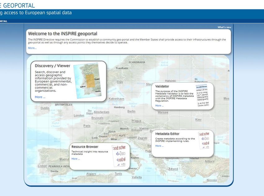
Member State is responsible for national official catalogues published in national
geoportals, feeding the EU-wide INSPIRE Geoportal, which includes data about buildings.

This report is an output of the EULF project and it was carried out upon DG Energy
request. It aims to assess the extent to which the buildings-related datasets which
European Member States are sharing following INSPIRE provisions are of good quality
and can serve the purposes of the initiatives related to energy efficiency of buildings.

The report is structured as follows: after this introduction, Section 2 provides some
underlying considerations related to the INSPIRE context and a description of the
INSPIRE data model for the theme “buildings”. Section 3 describes the methodology
adopted to select and analyse the datasets, whereas section 4 contains a summary of
the findings, as well as details of the datasets more deeply analysed. Section 5 shows
details of the inspected datasets analysed in a GIS environment and conclusions are
summed up in section 6.
Text in italics has been extracted from INSPIRE official documents4.

It is worth to note that building related datasets potentially relevant to energy policies
purposes that can be found in other data portals different from the INSPIRE geoportal,
are out of scope of the activities presented in this technical report.

4
    Available at http://inspire.ec.europa.eu/index.cfm

                                              6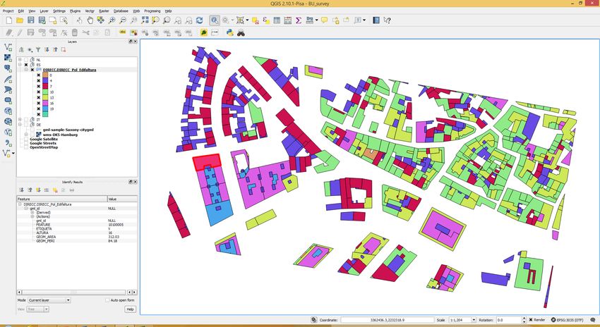
2. INSPIRE context
It is important to underline some considerations related to the INSPIRE context in which
the reported activities have been performed, in order not to overemphasise INSPIRE
expectations and benefits, which are still not easily measurable. At the same time, it is
worth to highlight and clarify the potential related to the implementation of the INSPIRE
provisions across the European Union.

INSPIRE has an implementation roadmap 5, shown in Figure 1, which sets deadlines for
Member States to make accessible in an harmonised and interoperable way datasets
belonging to 34 data themes (grouped into three Annexes), using specific data models
as well as specific web based network services.

Even though the deadline relevant to Annex I, II and III datasets are set in 2017 and
2020 respectively, there are intermediate deadlines (some of them already passed),
requiring that datasets published by Member States in their national geoportals have to
be made accessible through the INSPIRE geoportal, even though these datasets are not
yet conformant to the INSPIRE data models.

                          Figure 1: INSPIRE Implementation Roadmap 6

5
    http://inspire.ec.europa.eu/index.cfm/pageid/44
6
    http://inspire.ec.europa.eu/index.cfm/pageid/44

                                                 7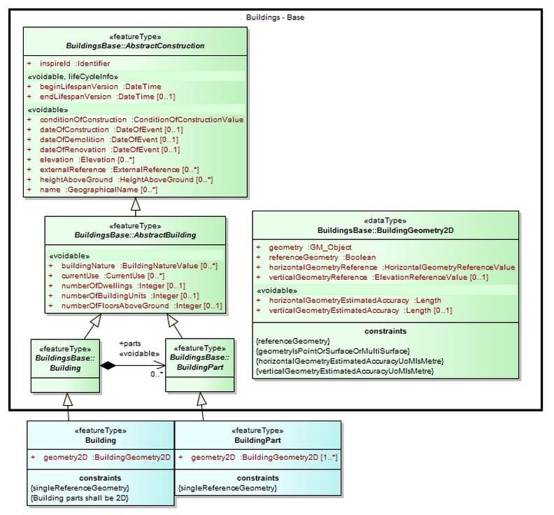
2.1    Relevance of BU (Buildings) datasets
Among the INSPIRE 34 data themes, “Buildings” is one of the most relevant to support
the energy policies lifecycle.

The INSPIRE Data Specification on Buildings7 [3] provides six different data models (or
application schemas), covering different levels of detail from the semantic and geometric
points of view (base vs. extended and 2D vs. 3D).

The relationships between the six application schemas are shown in Figure 2, in which
Feature types are represented in blue, abstract application schemas are represented in
green and instantiable application schemas are represented in red.

       Figure 2: Content and structure of application schemas for theme Buildings

It should be noted that various user requirements were collected by groups of experts in
order to define these data models. As stated in the INSPIRE Data Specification on
Buildings, “… Because it seemed impossible to require data harmonisation at European
level for all these requirements, the data specification on Buildings has defined some
priority ...”, as shown in the following Figure 3, in which “Feature types are represented
in bright colours, whereas their properties are represented in clearer colours”.

7
 http://inspire.jrc.ec.europa.eu/documents/Data_Specifications/INSPIRE_DataSpecification_BU_v3
.0.pdf

                                              8
Figure 3: The hierarchy of semantics user requirements
With reference to Figure 2 and Figure 3, as stated in the INSPIRE Data Specification on
Buildings, “… two kinds of semantic profiles are proposed in the data specification on
Buildings:
normative (i.e binding by law) core profile, based on the data widely used,
widely available and whose harmonisation is required at European level, e.g. for
homogeneous reporting on Environmental Directives;
informative (i.e. not binding by law) extended profile, based on data that is
widely required but whose harmonisation is not easily achievable at short term
(e.g. data rarely available or data whose harmonisation may/should be done at
national level).
The common semantics used by all profiles has been described in a base application
schema.
Core profile includes both basic topographic data (such as height, number of floors,
nature of buildings, date of construction …) and coarse official data (such as current use,
number of dwellings or of building units); the core profile aims to fulfil most user
requirements, at least in a rough way. Core profile is based on the concepts shown in
green in Figure 3.
Extended profile includes more detailed information about buildings and building related
objects. Extended profile is based on the concepts shown in pink in Figure 3 …”.
9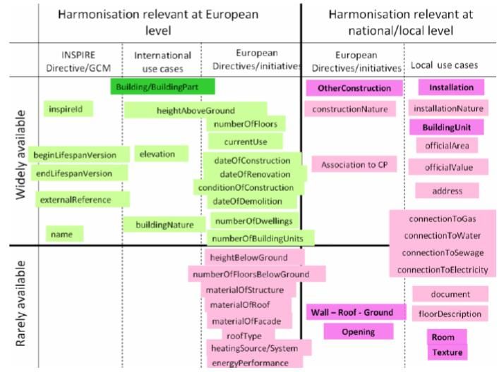
In summary, the six application schemas of the Buildings theme shown in Figure 2 are
listed and briefly described below:
“BuildingsBase, describing the concepts that are common to all other Buildings
application schemas; it contains mainly the core normative semantics of theme
Buildings;
Buildings2D, describing the 2D geometric representation of the spatial object
types defined in Buildings Base application schema, namely buildings and building
parts; it inherits from the common semantics of Buildings base
Buildings3D, describing the 3D geometric representation of the spatial object
types defined in Buildings Base application schema, namely buildings and building
parts; it inherits from the common semantics of Buildings base
BuildingsExtendedBase, describing the additional semantics that should be
used to extend normative profiles, whatever the chosen geometric representation
(2D or 3D) is.
BuildingsExtended2D, describing the 2D geometric representation of the
additional spatial object types (namely installations, other constructions, building
units); it inherits both from the common semantics of
and of the 2D geometric representation of buildings and building parts.
BuildingsExtended3D, describing both the 3D geometric representation of the
additional spatial object types (namely installations, other constructions, building
units) and the additional concepts that should be used to provide more detailed
information about buildings and associated objects, when represented by 3D data
(walls, roofs, openings, room, textures, …); it inherits both from the common
semantics of and of the 3D geometric representation
of buildings and building parts.”
Regarding the INSPIRE implementation roadmap, it is important to highlight that the
deadline of 2020 requires that Member States will have to make their datasets on
Buildings conformant to one of the two core profiles (Buildings2D or Buildings3D).
In the meanwhile, thematic communities are encouraged to use/refine the present draft
version of the extended data models and push their formal approval according to the
procedures set by the INSPIRE Maintenance and Implementation Framework 8.
Nevertheless, despite the issue of core versus extended data models, several aspects
affect the relevance of BU datasets to energy efficiency policies, because some of the
attributes are optional. Therefore, it cannot be expected that all data providers will
deliver datasets containing all this information.
In more technical terms, some of the attributes have the following characteristics:
9
They are voidable and/or optional in the binding-by-law BU core data model (e.g.
dateOfConstruction and currentUse in Figure 4);
They are voidable and/or optional in the draft BU extended data model (e.g.
energyPerformance, heatingSource, heatingSystem, materialOfFacade,
materialOfRoof, materialOfStructure in Figure 5).
8
http://inspire.ec.europa.eu/index.cfm/pageid/5160
9
The «voidable» stereotype is used to characterise those properties of a spatial object that may
not be present in some spatial data sets, even though they may be present or applicable in the
real world.
10Figure 4: BU Core 2D (Building2D) data model
11Figure 5: BU Extended Base data model
2.2 Fitness of INSPIRE BU data models for energy-related
purposes
As part of the EULF project, an initial mapping exercise has been carried out [2] between
12the building related elements of the data models required by EPBD 10 [4] and the
corresponding elements present in the INSPIRE data specification on Buildings. The main
outcome of this mapping exercise is that the building-related data models required by
EPBD and CoM 11 are semantically richer than the data models under INSPIRE. For
instance, Figure 6 shows the UML representation of the element of the INSPIRE Buildings
Base Extended data model (Feature Type BuildingAndBuildingUnitInfo) which deals with
energy related aspects.
Figure 6: INSPIRE Feature Type BuildingAndBuildingUnitInfo
From this figure it is evident that:
there are 4 boolean attributes which can be used just to store the information if
the building (or building unit) is connected or not to the different networks
12
(electricity, gas, sewage, water) ;
there is one attribute (energyPerformance) which can be used to store the
information related to the energy label;
there is one attribute (heatingSource) which can be used to store the information
related to the source of energy used for heating (i.e. electricity, naturalGas, etc.);
there is one attribute (heatingSystem) which can be used to store the information
related to the system of heating (i.e. stove, central heating, heat pump, etc.).
Conversely, there are additional attributes required by the EN 15603 standard [5] (on
which the EPBD data modelling requirements are based), like “Energy need” for heating,
cooling, ventilation, air conditioning, domestic hot water, lighting, appliances, which do
not match with any attribute existing in the current INSPIRE data model for buildings.
In general, because not all the elements of the data models required by EPBD and CoM
have a corresponding element in the relevant INSPIRE data model, these elements with
10
Energy Performance of Buildings Directive - http://eur-lex.europa.eu/legal-
content/EN/ALL/;ELX_SESSIONID=FZMjThLLzfxmmMCQGp2Y1s2d3TjwtD8QS3pqdkhXZbwqGwlgY
9KN!2064651424?uri=CELEX:32010L0031
11
Covenant of Mayors – http://www.covenantofmayors.eu/
12
It is worth noting the absence of a similar boolean attribute to identify buildings connected to
district heating network
13a missing correspondence with INSPIRE need to be further analysed in order to proper
address an extension of the existing relevant INSPIRE data models, considering that this
extension process is subject to precise rules and conditions, set to ensure that they do
not break the interoperability of harmonised data and services 13 [6].
It is also worth highlighting that the Citygml Energy ADE 14 initiative and the
GeoSmartCity15 project are working on similar topics and are producing results whose
reuse in the EULF Energy Pilot is also encouraged/recommended.
13
INSPIRE Generic Conceptual Model -
http://inspire.ec.europa.eu/documents/Data_Specifications/D2.5_v3.4.pdf
14
http://en.wiki.energy.sig3d.org/index.php/Main_Page
15
https://themes.jrc.ec.europa.eu/discussion/view/61352/extended-bu-data-model-for-energy-
efficiency
143. Methodology
The methodology adopted is based on a dataset discovery activity carried out using the
INSPIRE geoportal, which harvests the metadata published in the national official
catalogues developed and maintained by Member States.
The INSPIRE Geoportal, accessible at http://inspire-geoportal.ec.europa.eu/, offers
different tools, namely a metadata 16 editor, a metadata validator, a discovery/viewer
and a resource browser to find and view details of the datasets. Its home page is shown
in Figure 7. The tool used in this activity was the resource browser, in order to discover
BU related datasets potentially relevant for the scope of the work.
Each search made through the INSPIRE geoportal is based on real-time harvesting of the
metadata published in the official catalogues whose end point has been provided to JRC
by Member States. Therefore the number of results of an identical search repeated at
different points in time may differ, depending on the accessibility of the harvested
catalogues at the moment of the search.
In addition, coherently with the roadmap shown in Figure 1, in the INSPIRE geoportal it
is possible to find BU related datasets that are not yet conformant to INSPIRE data
models.
Figure 7: Home page of the INSPIRE geoportal
16
Metadata are information describing spatial data sets and spatial data services and making it
possible to discover, inventory and use them (definition from the INSPIRE glossary
http://inspire.ec.europa.eu/glossary/Metadata)
15STEP 1
Open Resource Browser
STEP 2
Select “Buildings” in the “Spatial Data Themes” search box
STEP 3
Select “Dataset” in the “Geoportal Resource Types” search box
STEP 4
Select the Member State of interest in the drop-down list
STEP 5
Select a resource and inspect its “INSPIRE metadata”
STEP 6
Extract relevant metadata elements and fill-in the excel file
template
STEP 7
Inspect the urls provided in the Resource locator MD element
STEP 8
Access the dataset consuming in QGIS the applicable NS
(Network Service), whose access point is provided in the
Resource locator MD element
STEP 9
Inspect the dataset in QGIS, focusing on the data model
STEP 10
Report in the excel file the fitness assessment
Figure 8: Steps of the methodology
Figure 8 shows the step by step methodology followed. The first four steps relate to the
connection to the resource browser and the selection of the search criteria in the fields
“Spatial Data Themes”, “Geoportal Resource Types” and “Member States”. The other
steps are explained more in detail below.
16Step 5
This step refers to the analysis of the INSPIRE metadata of a given resource found by
the search. For this report, only a few of the several hundreds of datasets returned by
the search have been selected for inspection (eight in total). This sampling was due to
the time consuming activities required by each inspection and also in order to complete
the overall activity in a reasonable time. The selection criteria adopted for the sampling
consisted in the identification of potentially relevant datasets using the information
contained in the two metadata elements “resource title” and “resource abstract”.
Indeed, a reading of the resource abstract sometimes led to the exclusion of datasets
from further inspection, e.g. points of interests representing historical buildings, complex
datasets containing topographic reference data including buildings footprints mixed to
many other layers.
At other times, a quick inspection of the URL provided in the “resource locator” metadata
element 17 was needed in order to decide to proceed with a deeper inspection or to
disregard the dataset.
Language issues were often encountered. In some cases the text provided in the original
metadata language did not allow the translator available in the INSPIRE geoportal to
deliver an English translation clear enough. In other cases the URL provided in the
resource locator metadata element was linked to a website not available in English and
therefore not usable for the scope of this activity.
Step 6
The following INSPIRE metadata elements were considered relevant to the scope of this
activity and therefore extracted from the Geoportal:
Resource title
Resource abstract
Lineage
Conditions applying to access and use
Limitations on public access
Resource locator
An excel file template was created to store the relevant information for each dataset
inspected (see Table 2).
Besides the six fields used to store the information contained in the six metadata
elements listed above, further fields were added in the excel file table to store the
following information (in step 10):
Member State;
Geographic coverage (e.g. name of the region/area covered);
18
Conformance to INSPIRE data models, i.e. to IR 1089 [7] (extracted from
“Conformity” metadata element);
17
This metadata element provides “the link(s) to the resource and/or the link to additional
information about the resource. The value domain of this metadata element is a character string,
commonly expressed as uniform resource locator (URL)”
18
INSPIRE Implementing Rule on interoperability of spatial data sets and services http://eur-
lex.europa.eu/legal-content/EN/TXT/PDF/?uri=CELEX:02010R1089-20131230&from=EN
17 Typology of resource locator (in addition to the URL, stored in another separate
field), e.g. WFS, WMS, ATOM, generic geoportal URL;
Dataset applicable/not-applicable to the objectives of the activity reported in this
document (this field is filled-in after full inspection of the dataset, including, for
some of them, processing in a Geographic Information System (GIS) software (in
19
this work, QGIS was used );
Additional remarks useful for the objectives of the activity reported in this
document.
Steps 7, 8 and 9
From the metadata accessible in the INSPIRE geoportal it is possible to obtain
information to either download the dataset (by means of WFS or ATOM protocols) or to
view it as a map (by means of WMS protocol), or both. In general, this activity has been
focused on the downloadable datasets, because they can be further analysed and
processed in a GIS client in an easy way. However, at a close inspection of some
datasets that were only accessible as maps (WMS), their relevance to the scope of this
activity was detected and therefore a deeper analysis was made. In this latter case,
focus was given to datasets whose corresponding view service (WMS) had the
GetFeatureInfo capability enabled (i.e. clicking on a feature shown on the map, the
corresponding attributes appear in a pop-up window).
For sake of completeness, also datasets assessed as “Not applicable” after the inspection
were documented in the template.
For two of the eight inspected datasets a deeper analysis of the data model was carried
out in Step 9 and a separate template was filled out, providing an English translation of
the relevant attributes, in order to facilitate a comparison with the INSPIRE BU data
model. This deeper analysis was restricted only to the two datasets containing more
attributes with respect to the others.
19
QGIS (www.qgis.org) is one of the most popular open source GIS desktop client tool
184. Summary of the findings
Table 1 and Figure 9 provide the results of the searches carried out on the INSPIRE
geoportal at two different dates.
From Table 1 it is evident that at the time of the first search the Spanish metadata
catalogue was not working properly and that only a subset of the German metadata
were harvested.
As explained above, only eight datasets were analysed and their full details are provided
in Table 2. The content of the cells of most of the columns has been copied/pasted from
the corresponding metadata elements. In order to make readable the whole content, the
table has been formatted splitting the columns into two blocks, repeating the first
column with the dataset ID in each block.
In Table 3 and in Table 4 the data models related to the datasets found for The
Netherlands and Italy are shown, respectively. Even though they are not conformant to
the INSPIRE data models, they were selected because they have several attributes
relevant to energy efficiency purposes.
Table 1: Distribution of number of BU datasets per MS at different dates
N. of N. of
datasets datasets
Country harvested on harvested on
2015-08-04 2015-09-08
at 14:50 at 11:16
AT 7 17
BE 7 14
CZ 1
DE 121 246
EE 2 2
ES 1 222
FI 67 66
FR 168 202
HR 2 3
HU 1 1
IE 1 1
IS 3 3
IT 1 1
LI 1 2
LV 5 5
NL 2 1
NO 11 11
PL 19 19
PT 13 13
RO 9 7
SE 7 10
SK 3 4
SL 2 2
UK 4 3
19Total 457 856
Figure 9: Distribution of number of BU datasets per MS (on 8 September 2015)
20Table 2: Details of the INSPIRE metadata elements of the eight inspected datasets
Conformance Region/area/co
Dataset ID MS Resource title Resource abstract Lineage
to 1089 verage
Given historically acquired on Scan 25
The corpus brings together buildings and movable objects or leaves cadastral georeferenced by
identified by the Service's inventory of heritage since 1997. It our care. Now, the acquisition from the
Inventaire du patrimoine contains also some from scanned files of previous censuses. digital cadastre provided by the
1 FR Bretagne
breton Folders have been created according to an XML format within Directorate General of taxes is the
the formalism of the DTD "CI", as it is advocated by the Ministry rule. Subsequently, conversion to the
of Culture (http://www.inventaire.culture.gouv.fr/). shape format resulted in the passage
in type point all data (point or polygon).
Provincial Built (edificato) of Built (edificato) of provincial capitals. The provincial capitals Data derived from the analysis and
2 IT
capitals provincial capitals. represented are those for the year 2003. interpretation of technical cartography.
This publication was created specifically to meet the theme
INSPIRE guidelines for buildings. It concerns building contours,
3 NL Whole country Buildings constructive elements and spatial barriers. This concerns non- Data from BAG and TOP10NL
harmonised data from the basic registration basic registration
Addresses and buildings (BAG) and Topography (TOP10NL).
21Applicable/N
Dataset ID Conditions Applying To Access And Use Limitations On Public Access Resource locator (1) Resource locator (2) Remarks
A
http://kartenn.region-
bretagne.fr/sviewer/?layers=rb:inventaire_pa
1. Out of scope (referred to historical
1. Display this layer in the trimoine
buildings and to movable objects)
1 simple Viewer NA
3. Few attributes
2. WFS http://ows.region-
2. High degree of non-conformance
bretagne.fr/geoserver/rb/wfs?SERVICE=WF
S&REQUEST=GetCapabilities
Extremely useful dataset (semantically
http://wms.pcn.minambiente.it/ogc?map=/m
reach and geometrically accurate),
This dataset is licensed under a Creative s_ogc/WMS_v1.3/Vettoriali/Edifici.map
1. WMS assuming to solve the actual
Commons Attribution-ShareAlike 3.0
problems in connecting to WFS.
Italy. Anyone wishing to reproduce or publish Public data http://www.pcn.minambiente.it/viewer/index.p
2 2. GN Viewer Applicable Quite poor level of info in MD.
the dataset containing processed has the unclassified hp?services=Edificato_Civici_Capoluoghi
Extent inconsistency between GN
obligation to respect the restrictions
3. WFS CSW and viewer.
established by the license. http://wms.pcn.minambiente.it/ogc?map=/m
Inconsistency between GN and RNDT
s_ogc/wfs/Edifici.map
CSW searches.
http://geodata.nationaalgeoregister.nl/bag/w
ms?
1. WMS (BAG)
http://geodata.nationaalgeoregister.nl/bag/wf
No restrictions
2. WFS (BAG) s?
http://creativecommons.org/pub 3 million of buildings (geometry,
3 No use restriction Applicable
licdomain/mark/1.0/deed.nl height class, status)
3. ATOM GML (top10NL) http://geodata.nationaalgeoregister.nl/top10
unclassified
nl/atom/top10nl.xml
4. WMS (top10NL)
http://geodata.nationaalgeoregister.nl/top10
nlv2/wms?
22Conformance Region/area/co
Dataset ID MS Resource title Resource abstract Lineage
to 1089 verage
Database of Estonian topography (ETAK) buildings of
ruumiandmekogumi form the ETAK reaalsusmudeli "buildings"
group of real-world phenomena, which is classified as a
nähtusklassideks: the buildings, kõrgrajatised, other facilities,
underground buildings, fencing. -in-the-Nähtusklassi >
buildings properties are: building type, the address of the
building. Nähtusklassi kõrgrajatised attributes are: kõrgrajatise
type the height of the kõrgrajatise, navigatsioonimärk,
kõrgrajatise, relationship building, the building of the ETAK_ID.
Ruumiandmekogumi "database of
Nähtusklassi other facilities the properties are: other type of
Estonian topograafi-buildings of" the
facility, navigatsioonimärk. Nähtusklassi underground buildings
quality of the data corresponds to the
Database of topography property is: land-base building type. Nähtusklassi guards
4 EE Whole country "Topographic data
in the Estonian-buildings properties are: type of barrier, piirdel Woody taxa. -in-the->
kaardistusjuhendile"
Estonian Foundation of and maintenance of the database, the
(http://geoportaal.maaamet.ee/docs/E
topography is based on a database, the topography of the
TAK/ETAK_juhend2013.pdf)
Estonian "Statute" and "Topographic data capture procedures
and the general meaning of owning the topographical
phenomena". ---> Main andmeallikateks are: aeropildistamise
and laserskaneerimise, the data obtained by, or their
derivatives, including the Ortho-photos; teabevaldajate in the
course of the Exchange by the transmitted data; mõõdistuste
made to the controller in the data; as a result of the surveys, and
other mõõdistamiste, including from public databases and
other sources of data.
There is a nationwide digital 3D.
Declared The digital 3D three-dimensional captured building. Each
Digital 3D, free State of Mostly, the buildings were recorded in
5 DE conformant to Saxony building model is differentiated according to the level of detail,
Saxony the LoD2. The remaining buildings
1089 the level of detail (LoD).
are in the LoD1.
23Applicable/N
Dataset ID Conditions Applying To Access And Use Limitations On Public Access Resource locator (1) Resource locator (2) Remarks
A
The disclosure of the data, and the grant of
use takes place through the online services. It was not possible to assess data
For more information, see http://geoportaal.maaamet.ee/est/Andmed-ja- content and quality, because no
4 http://geoportaal.maaamet.ee/est/Andmete- There are no restrictions on the geoportal url kaardid/Topograafilised-andmed/Eesti- ? download service is available and
tellimine/Digitaalsete-aluskaartide- topograafia-andmekogu-p79.html there are no building data listed in the
topograafiliste-ruumiandmete-tellimine- WMS list
p23.html
http://www.landesvermessung.sachsen.de/i
nhalt/produkte/dhm/3dm/3dm.html
1. geoportal url 1
http://www.landesvermessung.Sachsen.de/I MD reports conformance w.r.t. IR
Partially
5 There are no conditions. unclassified 2. geoportal url 2 nhalt/Produkte/DHM/3dm/3dm_best.html 1089, but the gml target schema is
applicable
citygml instead of buildings
3. geoportal url for download http://www.landesvermessung.Sachsen.de/I
nhalt/Produkte/DHM/3dm/3dm_download.ht
ml
24Conformance Region/area/co
Dataset ID MS Resource title Resource abstract Lineage
to 1089 verage
Floor plan loyalty figure of the Hamburg State area. Card
Foundation is the official land registry information system
Declared
City of Digital map 1: 5000 (ALKIS - content reduced), which is supplemented with The digital map 1: 5000 is part of
6 DE conformant to
Hamburg Hamburg topographic content and information. The DK5 is the digital basic geodata in Hamburg.
1089
edition of the former German base map (DGK) 1:5000. It serves
the economy, administration and planning.
A collection of Buildings was formed as a result of the
harmonization and integration of the database objects that
Declared contains Topograficzych objects, including buildings and other
Whole country
7 PL conformant to Buildings structures. The data have been restated in accordance with the Źrodłowe data BDOT10k
(??)
1089 model INSPIRE in terms of topic 3.2 described in the
specification "D 2.8. III. 2 Data Specification on Buildings-
Technical Guidelines".
Navarra Layer containing the buildings of Navarre excluding the
8 ES Buildings (visible) Information provided by the producer
Region underground constructions.
25Conditions Applying To Access And Applicable/N
Dataset ID Limitations On Public Access Resource locator (1) Resource locator (2) Remarks
Use A
1. http://www.geoportal-
1. jpg
Hamburg.de/hmdk_daten/DK5_300dpi.jpg
2. http://www.geoportal-
2. jpg
Hamburg.de/hmdk_daten/DK5_72dpi.jpg
3. http://Daten-
3. zip
Hamburg.de/geographie_geologie_geobasi
sdaten/Digitale_Karte_5000/Digitale_Karte_
5000_HH_2014-07-07.zip
4. http://Daten-
4. PDF
Hamburg.de/geographie_geologie_geobasi
Germany - data license attribution -
No sdaten/Digitale_Karte_5000/Digitale_Karte_
version 2.0; < a href = Link 3 allows to dowload 512MB of
Hamburg measurement Act 5000_HH_Legende_2014-09-11.PDF
"https://www.govdata.de/dl-de/by-2-0" raster tiles (png + pgw couples)
(HmbVermG) of 20 April 2005
> https://www.govdata.de/dl-de/by-2-0
6 Hamburg geo data 5. NA
< /a >. DL-de-by-2.0; Attribution: "Free Link 8 points to a wms exposing a
infrastructure Act (HmbGDIG) http://www.metaver.de/trefferanzeige?docuui
and Hanseatic City of Hamburg, 5. geoportal raster image with the building
Hamburg transparency law d=70B957B1-223A-406D-991B-
Landesbetrieb geoinformation and contours and no GetFeatureInfo
(HmbTG) 17775FAED3A1 & plugid = / ingrid group:
surveying, 2014"
dsc-scripted-HH & docid = 2075
6. http://geodienste-
6. WMS
Hamburg.de/HH_WMS_Kombi_DISK_GB?r
equest=GetCapabilities & SERVICE = WMS
7. http://geodienste-
7. WMS
Hamburg.de/HH_WMS_Geobasisdaten?req
uest=GetCapabilities & SERVICE = WMS
8. http://geodienste-
8. WMS
Hamburg.de/HH_WMS_DK5?request=GetC
apabilities & SERVICE = WMS
26Applicable/N
Dataset ID Conditions Applying To Access And Use Limitations On Public Access Resource locator (1) Resource locator (2) Remarks
A
Entity permissions on a shared resource
materials it use specifies the license issued
by the authority in providing these materials
in accordance with article 4. 40 c of the Act of
17 May 1989. Geodetic and cartographic law.
The fee for the sharing of resource materials
is the product of the respective basic rate,
number of units and the weightings or the
sum of such products. The amount of the
basic rate in respect of the relevant units, the
amount of the correction factors and the Download service that lets you
rules for determining these coefficients, as download INSPIRE buildings
well as the detailed rules for calculating the for Polish territory and the data
amount of the fee set out in the annex to the license subject in accordance with the http://mapy.geoportal.gov.pl/wss/service/ATO From the link provided it is not
7 NA
law. unclassified specifications of the ELF. The M/httpauth/atom/BU possible to access any data
Covered by the collection infrastructure and service uses the Atom interface
spatial data services, carried out by the version 1.0 and OpenSearch
Administration, subject to the provision of version 1.1.
nieodpłatnemu different administrations to
the extent necessary for the execution of
public tasks by them.
By sharing the harvest provisions of article
administrations. 15 of the law of 17 February
2005 on the informatization for bodies
pursuing public tasks shall apply mutatis
mutandis (article 14, paragraph 1 and
paragraph 2 of the law of 4 March 2010 for
the infrastructures for spatial information.
27Applicable/N
Dataset ID Conditions Applying To Access And Use Limitations On Public Access Resource locator (1) Resource locator (2) Remarks
A
This layer is released under the terms of the
license Creative Commons-Attribution (CC-
by 3.0). It will be necessary to name the
source of origin of the information in the
following manner: "geographical information From the geoportal it is possible to
owned by the Government of Navarre." download a dataset corresponding to
Department of Economics, finance, industry the geoportal viewer extent (if too
license http://idena.navarra.es/navegar/?layerid=DIR
8 and employment. Free public access: geoportal url Applicable large, it is limited to a portion of 1
unclassified ECC_Pol_Edifaltura
[http://idena.navarra.es] "more information square Km).
about the terms of use at: One of the few attributes is the
[http://www.navarra.es/home_es/Open- building height.
Data/Datos-abiertos/Terminos-de-uso-de-
Open-Data-Navarra/]
[http://creativecommons.org/licenses/by/3.0/]
"
28Table 3: Data model of the NL inspected dataset
Attribute (dutch) Attribute (EN) example value (dutch) example value (EN)
gml_id gml_id nl.top10nl.117782721
identificatie identifier nl.top10nl.117782721
brontype source type top10vector
Digitaal bestand met gecodeerde
vectoren. Deze geven tezamen de
bronbeschrijving source description topografie van Nederland weer
op de schaal 1:10.000. Voorloper
van Top10NL.
bronactualiteit 2005-01-01
bronnauwkeurigheid source accuracy 2
dimensie dimension 2D
objectBeginTiJd object start time 2008-11-24T00:00:00.000
versieBeginTijd version start time 2008-11-24T00:00:00.000
visualisatieCode visualization code 13000
tdnCode 170
hoogteklasse height class laagbouw Low-rise
hoogteniveau height level 0
status status in gebruik in use
typeGebouw type of buildings (1:religieus gebouw)
naamNL nameNL NULL
naamFries NULL
Table 4: Data model of the IT inspected dataset
Attribute (IT) Attribute (EN) example value
objectid_1
objectid
id_edifici
quota_suolo 55.7
quota_gronda 65.4
altezza building height 9.7
tipologia typology 4
area_ 3279.86
perimetro 225.3
codice_istat istat code 8035
provincia province REGGIO EMILIA
regione region EMILIA ROMAGNA
295. Analysis of the inspected datasets in a GIS environment
In the Step 9 of the methodology schematized in Figure 8, a QGIS project has been
created in order to test datasets usability in a GIS environment. The inspected datasets
have been accessed according to their availability, e.g. adding WFS/WMS layers or
simply adding gml files accessed by means of ATOM download services.
The following figures show screenshots relevant to the analysis performed.
Captions contain reference to the dataset examined, as well as information about the
particular aspect addressed by the GIS analysis.
The main outcome of the analysis is that accessing meaningful data through network
services enables data exploitation, e.g. using GIS clients to process the data in order to
extract value added information from them.
On the other hand, the analysis showed the importance to make such meaningful data
easily discoverable and accessible, e.g. providing correct metadata.
Moreover, the different data models used by the datasets analysed highlight the
potential of adopting a common target model to harmonize the semantic content of
heterogeneous data and ultimately to increase data interoperability and usability.
30Figure 10: IT dataset (dataset n. 2 in Table 2) published as WMS – scale view 1:25.000, Milan city centre
31Figure 11: IT dataset (dataset n. 2 in Table 2) published as WMS – scale view 1:5.000, Milan city centre (in the bottom left blue box are
visible the attributes of the red-circled building)
32Figure 12: NL dataset (dataset n. 3 in Table 2), consisting of 16 gml files containing 3 million of buildings accessed by means of ATOM
download services
33Figure 13: NL dataset (dataset n. 3 in Table 2) - zoomed view 1:25.000 of the city of Amsterdam
34Figure 14: DE dataset (dataset n. 5 in Table 2) - downloaded sample citygml LOD2 of Saxony region
35Figure 15: ES GML dataset (dataset n. 8 in Table 2) classified by means of building height attribute
366. Conclusions
The findings presented in this document show the usefulness of the INSPIRE geoportal to
discover building-related datasets which fit for the EULF Energy Pilot and the DG
Energy's EU Building Stock Observatory purposes.
It is worth to highlight that, coherently with the INSPIRE roadmap, in the INSPIRE
geoportal it is possible to find BU related datasets that are not yet conformant to
INSPIRE data models; and that the deadline of 2020 requires that Member States will
have to make their datasets on Buildings conformant to one of the two core profiles
(Buildings2D or Buildings3D), which contain only few attributes relevant to energy
policies.
A methodology applied to discover in the INSPIRE geoportal building-related datasets
has been described and its results documented, focusing primarily on datasets usability
in a GIS environment.
For this report, a sampling mechanism to select a small number of datasets (among the
several hundreds discovered in the INSPIRE geoportal) to be further inspected has been
adopted.
Even though the datasets inspected cannot be considered fully representative of all the
building related datasets present in the INSPIRE geoportal, they showed a still poor level
of harmonization across Europe (coherently with the INSPIRE roadmap). However the
analyses performed in a GIS environment evidenced that INSPIRE mechanisms to
harmonise Buildings related datasets according to semantically rich data models shared
by all MS and to make this harmonised datasets accessible through WFS download
services, can strongly support energy policies.
This support will be effective especially if the INSPIRE datasets (at building level) will be
elaborated in order to obtain aggregated indicators at local, regional or national level. In
its first version the EU Building Stock Observatory will collect national data only.
However, this tool could evolve to include sub-national data, and then INSPIRE could be
an important source of information.
As discussed above, the harmonised building datasets have to be accessible by the end
of 2020 so it would be appropriate to continue the monitoring of the datasets made
available, also to start the definition of new possible indicators at local level. The
methodology presented in this technical report can be easily reused “as-is” in order to
inspect more datasets.
Moreover, some recommendations can be addressed to INSPIRE implementers working
in energy thematic communities, in order to better address their efforts in fulfilling on-
going and future INSPIRE obligations:
to properly extend existing INSPIRE BU data models in order to take into account
the data modelling requirements coming from Energy policies, considering both
existing similar activities (e.g. citygml Energy ADE initiative and GeoSmartCity
project) and the rules for INSPIRE Data Specifications extension;
to use these extended data model as target data model in as many as possible
data harmonization processes related to energy efficiency of buildings, in order to
improve data interoperability at EU level;
to use the voidable properties of the INSPIRE data models only when the relevant
information is actually not available;
37 to carefully compile relevant metadata elements, such as lineage and resource
locator, in order to document and share relevant data processing activities and
therefore facilitate their reuse.
Concluding, the activities described in this report have been useful to better understand
the role of the INSPIRE buildings datasets in support of energy efficiency policies, and in
particular as a source of data for the Building Stock Observatory. Next steps would
include monitoring the availability of such datasets at the level of each Member States
and the analysis of their usability, in the course of INSPIRE implementation.
38References
1. European Commission, Directive 2007/2/EC establishing and Infrastructure for
Spatial Information in the European Community, http://eur-
lex.europa.eu/LexUriServ/LexUriServ.do?uri=OJ:L:2007:108:0001:0014:en:PDF
2. Bloem J., Boguslawski R., Borzacchiello M.T., Cipriano P., Kona A., Martirano G.,
Maschio I., Pignatelli F., Location data for buildings related energy efficiency policies,
JRC Technical Report, 2015, Publications Office of the European Union, ISBN 978-
92-79-50572-0 (pdf),
http://publications.jrc.ec.europa.eu/repository/handle/JRC96946
3. INSPIRE Thematic Working Group Buildings, D2.8.III.2 INSPIRE Data Specification
on Buildings – Technical Guidelines, 2013, European Commission Joint Research
Centre,
http://inspire.jrc.ec.europa.eu/documents/Data_Specifications/INSPIRE_DataSpecifi
cation_BU_v3.0.pdf
4. European Commission, Energy Performance of Buildings Directive, 2010, http://eur-
lex.europa.eu/legal-
content/EN/ALL/;ELX_SESSIONID=FZMjThLLzfxmmMCQGp2Y1s2d3TjwtD8QS3pqdkh
XZbwqGwlgY9KN!2064651424?uri=CELEX:32010L0031
5. European Committee for Standardization, EN 15603:2008 - Energy performance of
buildings. Overall energy use and definition of energy ratings
6. Drafting Team "Data Specifications", D2.5: Generic Conceptual Model - Version 3.4,
2014, Drafting Team "Data Specifications",
http://inspire.ec.europa.eu/documents/Data_Specifications/D2.5_v3.4.pdf
7. European Commission, COMMISSION REGULATION (EU) No 1089/2010 of 23
November 2010 implementing Directive 2007/2/EC of the European Parliament and
of the Council as regards interoperability of spatial data sets and services INSPIRE
Implementing Rule on interoperability of spatial data sets and services, 2010,
http://eur-lex.europa.eu/legal-content/EN/TXT/PDF/?uri=CELEX:02010R1089-
20131230&from=EN
39List of abbreviations and definitions
Acronym Description
BU Buildings
CP Cadastral Parcels
DS Data Specifications
GIS Geographic Information System
IR Implementing Rule
MD Metadata
MS Member State
NS Network Service
UML Unified Modelling Language
URL Uniform Resource Locator
WFS Web Feature Service
WMS Web Map Service
40List of figures
Figure 1: INSPIRE Implementation Roadmap ............................................................ 7
Figure 2: Content and structure of application schemas for theme Buildings ................. 8
Figure 3: The hierarchy of semantics user requirements............................................. 9
Figure 4: BU Core 2D (Building2D) data model ....................................................... 11
Figure 5: BU Extended Base data model ................................................................. 12
Figure 6: INSPIRE Feature Type BuildingAndBuildingUnitInfo .................................... 13
Figure 7: Home page of the INSPIRE geoportal ....................................................... 15
Figure 8: Steps of the methodology ....................................................................... 16
Figure 9: Distribution of number of BU datasets per MS (on 8 September 2015) ......... 20
Figure 10: IT dataset (dataset n. 2 in Table 2) published as WMS – scale view 1:25.000,
Milan city centre ........................................................................................... 31
Figure 11: IT dataset (dataset n. 2 in Table 2) published as WMS – scale view 1:5.000,
Milan city centre (in the bottom left blue box are visible the attributes of the red-
circled building) ............................................................................................ 32
Figure 12: NL dataset (dataset n. 3 in Table 2), consisting of 16 gml files containing 3
million of buildings accessed by means of ATOM download services .................... 33
Figure 13: NL dataset (dataset n. 3 in Table 2) - zoomed view 1:25.000 of the city of
Amsterdam .................................................................................................. 34
Figure 14: DE dataset (dataset n. 5 in Table 2) - downloaded sample citygml LOD2 of
Saxony region .............................................................................................. 35
Figure 15: ES GML dataset (dataset n. 8 in Table 2) classified by means of building
height attribute ............................................................................................ 36
Figures 2, 3, 4 and 5 have been extracted from the INSPIRE Data Specification on
Buildings20
20
http://inspire.jrc.ec.europa.eu/documents/Data_Specifications/INSPIRE_DataSpecification_BU_v3.
0.pdf
41List of tables
Table 1: Distribution of number of BU datasets per MS at different dates ................... 19
Table 2: Details of the INSPIRE metadata elements of the eight inspected datasets ..... 21
Table 3: Data model of the NL inspected dataset ..................................................... 29
Table 4: Data model of the IT inspected dataset ..................................................... 29
42Europe Direct is a service to help you find answers to your questions about the European Union Free phone number (*): 00 800 6 7 8 9 10 11 (*) Certain mobile telephone operators do not allow access to 00 800 numbers or these calls may be billed. A great deal of additional information on the European Union is available on the Internet. It can be accessed through the Europa server http://europa.eu How to obtain EU publications Our publications are available from EU Bookshop (http://bookshop.europa.eu), where you can place an order with the sales agent of your choice. The Publications Office has a worldwide network of sales agents. You can obtain their contact details by sending a fax to (352) 29 29-42758.
LF-NA-28014-EN-N
JRC Mission

As the Commission’s
in-house science service,
the Joint Research Centre’s
mission is to provide EU
policies with independent,
evidence-based scientific
and technical support
throughout the whole
policy cycle.

Working in close
cooperation with policy
Directorates-General,
the JRC addresses key
societal challenges while
stimulating innovation
through developing
new methods, tools
and standards, and sharing
its know-how with
the Member States,
the scientific community
and international partners.

Serving society
Stimulating innovation
Supporting legislation

doi:10.2791/46341

ISBN 978-92-79-59869-2
You can also read