CHINA FOREST COVER EXTRACTION BASED ON GOOGLE EARTH ENGINE
←
→
Page content transcription
If your browser does not render page correctly, please read the page content below
The International Archives of the Photogrammetry, Remote Sensing and Spatial Information Sciences, Volume XLII-3/W10, 2020
 International Conference on Geomatics in the Big Data Era (ICGBD), 15–17 November 2019, Guilin, Guangxi, China

 CHINA FOREST COVER EXTRACTION BASED ON GOOGLE EARTH
 ENGINE

 GUO Yan-tao1,2, ZHANG Xiao-mei1, LONG Teng-fei1, JIAO Wei-li1, HE Guo-jin1, YIN Ran-yu1,2,
 DONG Yun-yun1,2

 1. Aerospace Information Research Institute, Chinese Academy of Sciences, Beijing 100094, China;
 2. University of Chinese Academy of Sciences, Beijing 100049, China

 KEY WORDS: Google Earth Engine; Landsat 8; random forest; China forest cover;China forest area

 ABSTRACT:

 Forest cover rate is the principal indice to reflect the forest acount of a nation and region. In view of the difficulty of
 accurately calculating large-scale forest area by traditional statistical survey methods, it is proposed to extract China
 forest area based on Google Earth Engine platform. Trained by the enough samples selected through the Google
 Earth software, there are nine different random forest classifiers applicable to their corresponding zones. Using
 Landsat 8 surface reflectance data of 2018 year and the modified forest partition map, China forest cover is generated
 on the Google Earth Engine platform. The accuracy of China's forest coverage achieves 89.08%, while the accuracy
 of Global Forest Change datasets of Maryland university and Japan’s ALOS Forest/Non-Forest forest product reach
 87.78% and 84.57%. Besides, the precision of tropical/subtropical forest , temperate coniferous forest as well as
 nonforest region are 83.25% , 87.94% and 97.83%, higher than those of other’s accuracy. Our results show that by
 means of the random forest algorithm and enough samples, tropical and subtropical broadleaf forest, temperate
 coniferous forest and nonforest partition can be extracted more accurately. Through the computation of forest cover,
 our result shows that China has a area of 220.42 million hectare in 2018.

 1.INTRODUCTION countries in the world and international research
 institutes conduct a series of investigations on the topic
 Among many earth systematical processings,
 of different scale land cover mapping.
 vagetation land cover is the indispensible element.
 Forest detection already raises wide concern of
 Vegetation land cover is required by a number of
 international society and achives s series of results.
 general to be the boundary layer of execution
 Recently, remote sensing satellite data reveal a
 model(Sellers et al. 1997). As a significant component
 greening pattern that is strikingly prominent in China
 of land cover research topics, forest cover detection is
 and India and overlaps with croplands world-wide and
 now more than ever becoming the focus of scientific
 China alone accounts for 25% of the global net increase
 research and resource management projects,such as
 in leaf area with only 6.6% of global vegetated
 investigating climate change, food security, habitat
 area(Chen et al. 2019). Meanwhile, mangrove forests
 loss(Foley et al. 2005). The purpose of mapping large
 along the coastal zones in China were mapped by
 area forest is producing globally consistent characters
 integration of the GEE platform, time series Landsat
 possessing local relevance and practicability, in other
 and Sentine-1A SAR images(Chen et al. 2017).
 words, cross-scale reliable information(Hansen et al.
 Besides, PALSAR-based forest map in China
 2013). Due to the significance of forest cover data,

 This contribution has been peer-reviewed.
 https://doi.org/10.5194/isprs-archives-XLII-3-W10-855-2020 | © Authors 2020. CC BY 4.0 License. 855
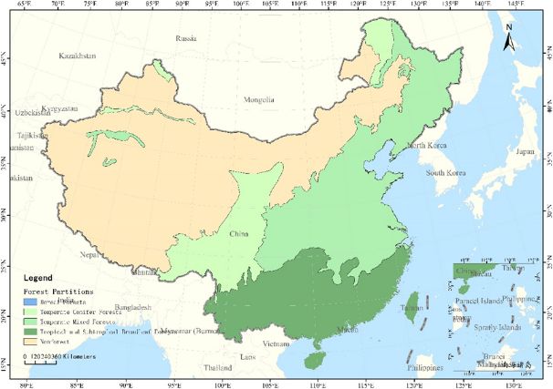
The International Archives of the Photogrammetry, Remote Sensing and Spatial Information Sciences, Volume XLII-3/W10, 2020
 International Conference on Geomatics in the Big Data Era (ICGBD), 15–17 November 2019, Guilin, Guangxi, China

 demonstrate the potential of integrating PALSAR and map with Global Forest Change data and Forest/Non-
 MODIS images to map forests in large areas(Qin et al. Forest data.
 2015). On the other hand, some novel approachs were
 proposed to produce more accurate 25m forest maps by 2.CHINA FOREST PARTITION
 integrating PALSAR/PALSAR-2 and MODIS NDVI
 Global land covers are usually divided into fourteen
 data during 2007–2010 and reconstruct annual 25m
 biocoenosis and eight geographic zones and China has
 forest maps from time-series MODIS NDVI images
 eight biocoenosis(Olson and Dinerstein 2002; Olson et
 during 2011–2014(Zhang et al. 2019). To minimize the
 al. 2001). In this study,we merge eight biocoenosis in
 influence of the changing ground footprint of MODIS,
 China into five forest partitions to assist extraction of
 there were two new algorithms and a new assessment
 different forest. The five forest partitions are boreal
 framework for near real-time monitoring of tropical
 forest, temperate coniferous forest, temperate cross
 forest disturbance(Tang et al. 2019). Referring to the
 forest, tropical/subtropical forest and nonforest.
 global forest cover datasets, there are four
 Forest Partitions Biocoenosis
 representitive products alternative: (1) The Global
 Forest Change map (GFC) product proviede by the Boreal Forests Boreal Forests/Taiga
 Maryland university(Hansen et al. 2013). (2) The Temperate Conifer Temperate Conifer Forests
 PALSAR/PALSAR-2 mosaic and forest/non-forest Forests
 (FNF) map produced by Japan Aerospace Exploration Temperate Mixed Temperate Broadleaf and
 Agency (JAXA) (Shimada et al. 2014). (3) The first Forests Mixed Forests
 30m and 10m resolution global land-cover maps Tropical and Tropical and Subtropical
 created by Landsat Themtic Mapper (TM) and Subtropical Broadleaf Forests
 Enhanced Thematic Mapper Plus (EMT+) data(Gong Broadleaf Forests
 et al. 2019; Gong et al. 2013). (4) The Global Land Nonforest Temperate Grasslands,
 Cover (GLC) mapping at 30m resolution based on a Savannas and Shrublands
 POK-based operational approach supplied by National
 Flooded Grasslands ,Savannas
 Geomatics Center of China(Chen et al. 2015).
 Montane Grasslands and
 Comparing above products, there are some problem
 Shrublands
 existing on the data processing and reprocessing, or the
 Deserts and Xeric Shrublands
 precision to be improved. Therefore, how to produce
 Table 1. Mapping relation between forest partitions
 big scale forest maps efficiently and precisely is a
 and biocoenosis
 puzzle to be solved.
 The Google Earth Engine based on cloud compute
 platform combines the high-performance abilities with
 large=scale geographic data processing missions. This
 solution settles a train of major information technology
 challenges,such as data acquisition and storage, file
 pattern analysis, database management and equipment
 distribution(Gorelick et al. 2017).
 In this study, we produce China forest cover maps of
 different partitions in 2018 using Google Earth Engine
 Figure 1. China forest partitions
 for data acquisition and operation platform. This forest
 distribution product is made from Landsat image data
 and random forest classification method. To guarantee
 the accuracy of this map, this study compares the forest

 This contribution has been peer-reviewed.
 https://doi.org/10.5194/isprs-archives-XLII-3-W10-855-2020 | © Authors 2020. CC BY 4.0 License. 856
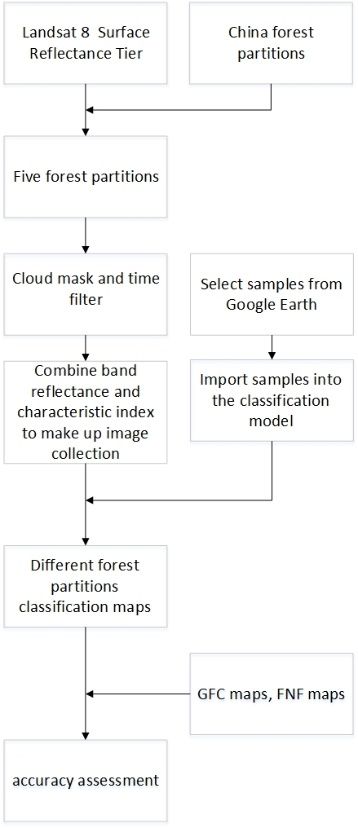
The International Archives of the Photogrammetry, Remote Sensing and Spatial Information Sciences, Volume XLII-3/W10, 2020
 International Conference on Geomatics in the Big Data Era (ICGBD), 15–17 November 2019, Guilin, Guangxi, China

 3.DATASETS AND RESEARCH METHODS indexes are computed to act as character indexes for
 different land cover species. These indexes include
 Google Earth Engine (GEE) contains a a range of
 Normalized Difference Vegetation Index (NDVI)
 Landsat image collections, among which is Landsat-8
 (Tucker 1979) , Normalized Difference Water Index
 Surface Reflectance Tier and it comes from Landsat 8
 (NDWI) (Gao 1996) , Normalized Difference Built-up
 Operational Land Imager (OLI) and Thermal Infrared
 Index (NDBI) (Zha et al. 2003), Normalized Difference
 Sensor (TIRS).
 Moisture Index (NDMI) (Wilson and Sader 2002) ,
 In this paper, the USGS Landsat-8 Surface Reflectance
 Global Environment Monitoring Index (GEMI) (Pinty
 Tier datasets are used for import data, which is provied
 and Verstraete 1992) and Soil Adjusted Vegetation
 by GEE. These data have been atmospherically
 Index (SAVI) (Huete 1988). Normalized Difference
 corrected using Landsat Surface Reflectance Code
 Vegetation Index is sensitive to vegetation greenness
 (LaSRC) (Vermote et al. 2016) and includes a cloud,
 and can be employed to monitor the photosynthetically
 shadow, water and snow mask produced using C
 active biomass of plant canopies. Normalized
 Function of Mask (CFMASK) (Zhu and Woodcock
 Difference Water Index is sensitive to changes in liquid
 2014) , as well as a per-pixel saturation mask.
 water content of vegetation canopies and less sensitive
 Meanwhile, we select the median time images after
 to atmospheric effects than Normalized Difference
 cloud clear in different partitions to serve as the train
 Vegetation Index. Normalized Difference Built-up
 data and classification data of the partition. The
 Index is much more effective and advantageous in
 influence of cloud and shadow can greatly be avoided
 mapping general built-up areas, which can serve as a
 by mean of the operations.
 worthwhile alternative for quickly mapping nonforest
 land. Some study shows that the less common
 Normalized Difference Moisture Index method
 (utilizing the middle infrared band instead of the visible
 red) produced significantly higher accuracies for
 detecting forest harvest in all classification trials.
 Global Environment Monitoring Index reduces the
 relative effects of these undesirable atmospheric
 perturbations, while maintaining the information about
 the vegetation cover. Soil-adjusted vegetation index is
 found to be an important step toward the establishment
 of simple "global" models that can describe dynamic
 soil-vegetation systems from remotely sensed data. The
 six spectral indexes are combined with six band
 reflectances.

 3.2 Training samples

 On the basis of the forest density in various partitions,
 Figure 2. China forest cover detection flowchart a diifferent number of samples are selected as training
 data. Referring to near-real time high-resolution image
 3.1 Index computation collection on the Google Earth software, these datasets
 are labelled on forest,nonforest or water,in order to
 In order to avoid the cloud and shadow influence,
 correspond to the classification labels of GFC and FNF
 quality assessment band is used for mask band to reject
 products. The training pixels are extracted randomly.
 the cloud pixels. After that operation, six spectral
 To ensure only clearly forest pixels were selected, the

 This contribution has been peer-reviewed.
 https://doi.org/10.5194/isprs-archives-XLII-3-W10-855-2020 | © Authors 2020. CC BY 4.0 License. 857
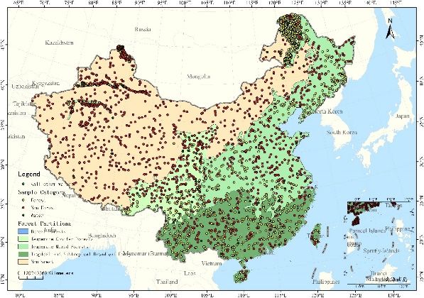
The International Archives of the Photogrammetry, Remote Sensing and Spatial Information Sciences, Volume XLII-3/W10, 2020
 International Conference on Geomatics in the Big Data Era (ICGBD), 15–17 November 2019, Guilin, Guangxi, China

 forest samples were collected carefully to avoid pixels randomly. The generalization error of random forest is
 near the boundary of forest(Bastarrika et al. 2011). dicided by the individual structural strength and
 Study Sample Number relevance of decision trees in the forest. The formula of
 Area Forest Non- Water random forest is expressed as
 Forest
 Nonforest 66 1474 36 (1)
 Boreal Forest 39 10 4 Where ( ) indicates the random forest integrated
 Tropical and 626 444 10 classification model, ℎ indicates single decision tree,
 Subtropical indicates the output variable , ( ∙ ) indicates the

 Broadleaf Forest indicator function which ranges from 0 and 1.

 Temperate 824 1505 68 The advantage of random forest algorithm lies in usage

 Mixed Forest of out-of-bag cross-validaton (OOBCV) to realise

 Temperate 1017 889 37 overall evaluation of classification accuracy.

 Conifer Forest Compared with Adaboost, random forest utilizes

 China 2572 4322 155 characters selected randomly to split error ratio of
 every node domain, thus this model has better stability
 Table 2.The training sample numbers for the forest
 in noise reduction and anti-interference aspects.
 ,nonforest and water in each partition.
 Overall evaluation manages the interior error, structure
 and relevance of forest model by means of estimating
 the posterior probability of every node in the decision
 tree of random forest. These indices indicate the
 response of character number increase which are
 applied by segmentation. Not only that, overall
 estimation also evaluates the significance of variable
 (Breiman 2001).
 Because of multiplicate input characters including six
 bands of surface reflectance and six specific spectral
 Figure 3. The samples map of distribution
 indexes, the number of decision trees in the random
 forest model was limited to 500 to balance accuracy
 3.3Model Training
 and timeliness.
 The random forest algorithm provided by GEE was Classification results are hard voting of three labels.
 applied to train the forest classifier. Compared with This is the overall consequences of all decision trees in
 decision tree algorithm creating GFC maps, the random the classifier. In the other hand, random forest classifier
 forest classifier contains more numbers of decision can also export the probability of each category. This
 trees. The Random Forest classifier uses bootstrap results act as the confidence level output of every
 aggregating for form an ensemble of classification and category,which contain the confidence index ranging
 induction tree like tree classifiers. This structure means from 0 to 1.
 that random forest model has more robustness and 4. CLASSIFICATION RESULT AND
 higher anti-interference. Random forest has become ACCURACY ANALYSIS
 one of the high accuracy and widely applicable
 4.1 Classification results
 algorithms(Pal 2005). Random forest is a ensamble
 composed of decision trees acted as basic learners, In view of area forest partion, different number of
 while all learners in the forest have same distribution validation points were produced for every study region.
 and every attribute of decision tree depends on the After that, extract the real categories of points based on
 spectral characters choosed independently and

 This contribution has been peer-reviewed.
 https://doi.org/10.5194/isprs-archives-XLII-3-W10-855-2020 | © Authors 2020. CC BY 4.0 License. 858
The International Archives of the Photogrammetry, Remote Sensing and Spatial Information Sciences, Volume XLII-3/W10, 2020 International Conference on Geomatics in the Big Data Era (ICGBD), 15–17 November 2019, Guilin, Guangxi, China the high resolution images in the Google Earth software Study Area Kappa Coefficient and the three forest maps, thus we obtained the error RF FNF GFC matrixs of classification results. At Last, the overall Tropical and accuracy (OA) and kappa coefficients (KCs) were 0.6735 0.3985 0.4794 Subtropical computed by the error matrixs. Broadleaf k x ii Forests OA i 1 (2) Temperate 0.7513 0.6197 0.7209 N Conifer k k x x ii i x i (3) Forests KC s i 1 k i 1 N 2 ( xi x i ) Nonforest 0.4957 0.2100 0.2879 i 1 Where N indicates the pixels used in the accuracy Temperate 0.6335 0.5663 0.6057 assessment, x_ii indicates the overall number of the Mixed Forests class i pixels classified correctly, x_(i+) indicates the Boreal Forests 0.00 0.00 0.5640 number of class i pixels in classification results, x_(+i) China indicates the number of class i pixels in validation 0.7503 0.6367 0.7088 results. Table 4. The kappa coefficients of the three forest maps in five partitions 4.3 Local comparision of forest detection In this part, four forest extractions of four forest partitions are compared to analysis the reason of misclassification and missorting. Fig 4 shows the original images and forest extraction results of four forest partitions including Tropical and Subtropical Figure 4. The forest extraction result in China Broadleaf Forests(a1,a2,a3,a4), Temperate Conifer Forests of Notheast(b1,b2,b3,b4), Temperate 4.2 Classification accuracy Conifer Forests of Southwest (c1,c2,c3,c4) and Study Area Overall Accuracy(%) Temperate Mixed Forests of East (d1,d2,d3,d4) , while the classification differences are highlighted by the RF FNF GFC yellow circles. Tropical and 83.25% 69.25% 73.25% In the tropical and subtropical broadleaf forests, forests Subtropical weren’t extracted in the FNF product compared with Broadleaf the RF product. When it comes to GFC product,some Forests non-forest regions weren’t classified ,such as road and Temperate 87.94% 81.81% 86.87% lake. In the temperate conifer forests of northeast, FNF Conifer map and GFC map appear large area of forest Forests misclassification while RF map seperates forest and Nonforest 97.83% 95.50% 96.83% non-forest well. The reason of this situation may be Temperate 87.90% 87.40% 88.70% local forest density is sparse and unlikely to be Mixed Forests discrinible considering the origin image. In the Boreal Forests 90.00% 93.00% 97.00% temperate conifer forest of southwest, there are China 89.08% 84.57% 87.78% Table 3. The overall accuracy of the three forest maps in five partitions This contribution has been peer-reviewed. https://doi.org/10.5194/isprs-archives-XLII-3-W10-855-2020 | © Authors 2020. CC BY 4.0 License. 859
The International Archives of the Photogrammetry, Remote Sensing and Spatial Information Sciences, Volume XLII-3/W10, 2020
 International Conference on Geomatics in the Big Data Era (ICGBD), 15–17 November 2019, Guilin, Guangxi, China

 different levels of forest misclassification cases in the Temperate Conifer Forests 3691.2586
 mountain regions of FNF product and GFC product. In China 22042.23
 the temperate mixed forest of east, FNF product has Table 5. Forest area in different forest
 serious missorting situations when roads and grassland partitions.
 in the city region are divided into forest. Some trees on
 the boundary of forest in the GFC product are classified 5.CONCLUSION
 as non-forest. On the contrary, RF product extracts the
 This work demonstrates that the classifier trained by
 boundary of forest better and reduces the missortting of
 random forest algorithm extracts China forest cover
 non-forest vegetation in the urban area. In summary,
 better and achives the overall accuracy of 89.08%. It’s
 the classification accuracy of forest product created by
 not to be ignored that this classifier has better
 random forest algoriothm in the GEE platform is higher
 performance in the extraction of forest in tropical and
 than those of GFC and FNF.
 subtropical broadleaf forests, temperate conifer forests
 and temperate mixed forests. In addition, the process
 speed in the Google Earth Engine platform is high, thus
 the time cost of data download and data selection can
 be saved.
 (a1) (a2) (a3) (a4)
 Although this work has attained superior result of forest
 cover extraction ,there are still some challenges
 remained to be solved. For example, due to the cloud
 cover and shadow in the data all the year round, there
 are data deficiency in the classification result. In the
 (b1) (b2) (b3) (b4)
 other hand, there are some salt pepper effect in some
 districts as calculated based on the pixel. So it’s
 neccesary to introduce the method of object-based to
 avoid the misclassification. In addition, there are more
 data could be applied to classify the forest types, such
 (c1) (c2) (c3) (c4)
 as digital elevation model and hyperspectral images.

 ACKNOWLEDGEMENTS

 This work was supported by the National Key
 (d1) (d2) (d3) (d4) Research and Development Programs of China
 Figure 5. Local comparision of forest detection [grant numbers 2016YFA0600302], the
 in different partitions Strategic Priority Research Program of the
 Chinese Academy of Sciences [grant number
 4.4 Area computation XDA19090300], the program of the National
 Forest partition Area( Ten
 Natural Science Foundation of China [grant
 thousand hectare)
 number 61731022].
 REFERENCES
 Nonforest 663.1828
 Boreal Forests 0.6885 Bastarrika, A., Chuvieco, E., & Martín, M.P.
 Tropical and Subtropical 10195.1802 (2011). Mapping burned areas from Landsat
 Broadleaf Forests TM/ETM+ data with a two-phase algorithm:
 Temperate Mixed Forests 7491.9180 Balancing omission and commission errors.
 Remote Sensing of Environment, 115, 1003-1012

 This contribution has been peer-reviewed.
 https://doi.org/10.5194/isprs-archives-XLII-3-W10-855-2020 | © Authors 2020. CC BY 4.0 License. 860
The International Archives of the Photogrammetry, Remote Sensing and Spatial Information Sciences, Volume XLII-3/W10, 2020
 International Conference on Geomatics in the Big Data Era (ICGBD), 15–17 November 2019, Guilin, Guangxi, China

 Breiman, L. (2001). Random Forests. Machine X., Xiao, F., Liu, Q., & Song, L. (2019). Stable
 Learning, 45, 5-32 classification with limited sample: transferring a
 Chen, B., Xiao, X., Li, X., Pan, L., Doughty, R., Ma, 30-m resolution sample set collected in 2015 to
 J., Dong, J., Qin, Y., Zhao, B., Wu, Z., Sun, R., Lan, mapping 10-m resolution global land cover in
 G., Xie, G., Clinton, N., & Giri, C. (2017). A 2017. Science Bulletin
 mangrove forest map of China in 2015: Analysis Gong, P., Wang, J., Yu, L., Zhao, Y., Zhao, Y., Liang,
 of time series Landsat 7/8 and Sentinel-1A L., Niu, Z., Huang, X., Fu, H., Liu, S., Li, C., Li, X., Fu,
 imagery in Google Earth Engine cloud computing W., Liu, C., Xu, Y., Wang, X., Cheng, Q., Hu, L., Yao,
 platform. ISPRS Journal of Photogrammetry and W., Zhang, H., Zhu, P., Zhao, Z., Zhang, H., Zheng,
 Remote Sensing, 131, 104-120 Y., Ji, L., Zhang, Y., Chen, H., Yan, A., Guo, J., Yu,
 Chen, C., Park, T., Wang, X., Piao, S., Xu, B., L., Wang, L., Liu, X., Shi, T., Zhu, M., Chen, Y.,
 Chaturvedi, R.K., Fuchs, R., Brovkin, V., Ciais, P., Yang, G., Tang, P., Xu, B., Giri, C., Clinton, N., Zhu,
 Fensholt, R., Tømmervik, H., Bala, G., Zhu, Z., Z., Chen, J., & Chen, J. (2013). Finer resolution
 Nemani, R.R., & Myneni, R.B. (2019). China and observation and monitoring of global land cover:
 India lead in greening of the world through land- first mapping results with Landsat TM and ETM+
 use management. Nature Sustainability, 2, 122- data. International Journal of Remote Sensing,
 129 34, 2607-2654
 Chen, J., Chen, J., Liao, A., Cao, X., Chen, L., Chen, Gorelick, N., Hancher, M., Dixon, M.,
 X., He, C., Han, G., Peng, S., Lu, M., Zhang, W., Ilyushchenko, S., Thau, D., & Moore, R. (2017).
 Tong, X., & Mills, J. (2015). Global land cover Google Earth Engine: Planetary-scale geospatial
 mapping at 30m resolution: A POK-based analysis for everyone. Remote Sensing of
 operational approach. ISPRS Journal of Environment, 202, 18-27
 Photogrammetry and Remote Sensing, 103, 7-27 Hansen, M.C., Potapov, P.V., Moore, R., Hancher,
 Cossu, R., Petitdidier, M., Linford, J., Badoux, V., M., Turubanova, S.A., Tyukavina, A., Thau, D.,
 Fusco, L., Gotab, B., Hluchy, L., Lecca, G., Murgia, Stehman, S.V., Goetz, S.J., Loveland, T.R.,
 F., & Plevier, C. (2010). A roadmap for a Kommareddy, A., Egorov, A., Chini, L., Justice,
 dedicated Earth Science Grid platform. Earth C.O., & Townshend, J.R.G. (2013). High-
 Science Informatics, 3, 135-148 Resolution Global Maps of 21st-Century Forest
 Foley, J.A., DeFries, R., Asner, G.P., Barford, C., Cover Change. Science, 342, 850
 Bonan, G., Carpenter, S.R., Chapin, F.S., Coe, Huete, A.R. (1988). A soil-adjusted vegetation
 M.T., Daily, G.C., Gibbs, H.K., Helkowski, J.H., index (SAVI). Remote Sensing of Environment, 25,
 Holloway, T., Howard, E.A., Kucharik, C.J., 295-309
 Monfreda, C., Patz, J.A., Prentice, I.C., Olson, D.M., & Dinerstein, E. (2002). The Global
 Ramankutty, N., & Snyder, P.K. (2005). Global 200: Priority Ecoregions for Global Conservation.
 Consequences of Land Use. Science, 309, 570 Annals of the Missouri Botanical Garden, 89, 199-
 Gao, B.-c. (1996). NDWI—A normalized 224
 difference water index for remote sensing of Olson, D.M., Dinerstein, E., Wikramanayake,
 vegetation liquid water from space. Remote E.D., Burgess, N.D., Powell, G.V.N., Underwood,
 Sensing of Environment, 58, 257-266 E.C., D'Amico, J.A., Itoua, I., Strand, H.E.,
 Gong, P., Liu, H., Zhang, M., Li, C., Wang, J., Morrison, J.C., Loucks, C.J., Allnutt, T.F., Ricketts,
 Huang, H., Clinton, N., Ji, L., Li, W., Bai, Y., Chen, T.H., Kura, Y., Lamoreux, J.F., Wettengel, W.W.,
 B., Xu, B., Zhu, Z., Yuan, C., Ping Suen, H., Guo, J., Hedao, P., & Kassem, K.R. (2001). Terrestrial
 Xu, N., Li, W., Zhao, Y., Yang, J., Yu, C., Wang, X., Ecoregions of the World: A New Map of Life on
 Fu, H., Yu, L., Dronova, I., Hui, F., Cheng, X., Shi, EarthA new global map of terrestrial ecoregions

 This contribution has been peer-reviewed.
 https://doi.org/10.5194/isprs-archives-XLII-3-W10-855-2020 | © Authors 2020. CC BY 4.0 License. 861
The International Archives of the Photogrammetry, Remote Sensing and Spatial Information Sciences, Volume XLII-3/W10, 2020
 International Conference on Geomatics in the Big Data Era (ICGBD), 15–17 November 2019, Guilin, Guangxi, China

 provides an innovative tool for conserving Zha, Y., Gao, J., & Ni, S. (2003). Use of normalized
 biodiversity. BioScience, 51, 933-938 difference built-up index in automatically
 Pal, M. (2005). Random forest classifier for mapping urban areas from TM imagery.
 remote sensing classification International International Journal of Remote Sensing, 24, 583-
 Journal of Remote Sensing, 26, 217-222 594
 Pinty, B., & Verstraete, M.M. (1992). GEMI: a Zhang, Y., Ling, F., Foody, G.M., Ge, Y., Boyd, D.S.,
 non-linear index to monitor global vegetation Li, X., Du, Y., & Atkinson, P.M. (2019). Mapping
 from satellites. Vegetatio, 101, 15-20 annual forest cover by fusing PALSAR/PALSAR-2
 Qin, Y., Xiao, X., Dong, J., Zhang, G., Shimada, M., and MODIS NDVI during 2007–2016. Remote
 Liu, J., Li, C., Kou, W., & Moore, B. (2015). Forest Sensing of Environment, 224, 74-91
 cover maps of China in 2010 from multiple Zhu, Z., & Woodcock, C.E. (2014). Automated
 approaches and data sources: PALSAR, Landsat, cloud, cloud shadow, and snow detection in
 MODIS, FRA, and NFI. ISPRS Journal of multitemporal Landsat data: An algorithm
 Photogrammetry and Remote Sensing, 109, 1-16 designed specifically for monitoring land cover
 Sellers, P.J., Dickinson, R.E., Randall, D.A., Betts, change. Remote Sensing of Environment, 152,
 A.K., Hall, F.G., Berry, J.A., Collatz, G.J., Denning, 217-234
 A.S., Mooney, H.A., Nobre, C.A., Sato, N., Field,
 C.B., & Henderson-Sellers, A. (1997). Modeling
 the Exchanges of Energy, Water, and Carbon
 Between Continents and the Atmosphere.
 Science, 275, 502-509
 Shimada, M., Itoh, T., Motooka, T., Watanabe,
 M., Shiraishi, T., Thapa, R., & Lucas, R. (2014).
 New global forest/non-forest maps from ALOS
 PALSAR data (2007–2010). Remote Sensing of
 Environment, 155, 13-31
 Tang, X., Bullock, E.L., Olofsson, P., Estel, S., &
 Woodcock, C.E. (2019). Near real-time
 monitoring of tropical forest disturbance: New
 algorithms and assessment framework. Remote
 Sensing of Environment, 224, 202-218
 Tucker, C.J. (1979). Red and photographic
 infrared linear combinations for monitoring
 vegetation. Remote Sensing of Environment, 8,
 127-150
 Vermote, E., Justice, C., Claverie, M., & Franch, B.
 (2016). Preliminary analysis of the performance
 of the Landsat 8/OLI land surface reflectance
 product. Remote Sensing of Environment, 185,
 46-56
 Wilson, E.H., & Sader, S.A. (2002). Detection of
 forest harvest type using multiple dates of
 Landsat TM imagery. Remote Sensing of
 Environment, 80, 385-396

 This contribution has been peer-reviewed.
 https://doi.org/10.5194/isprs-archives-XLII-3-W10-855-2020 | © Authors 2020. CC BY 4.0 License. 862
You can also read