CLIMATE LINKED ATLANTIC SECTOR SCIENCE REPORT 2021
←
→
Page content transcription
If your browser does not render page correctly, please read the page content below
CLIMATE LINKED ATLANTIC
SECTOR SCIENCE
REPORT 2021
Providing an update on understanding of the science and impacts of the changing
Atlantic Ocean
5 UK Marine Science centres
230 papers published in 2018-2020, including
17 in high impact journals Nature and Science
1500+ citations
800+
Continuous Plankton
Recorder Survey times CLASS publications
have been picked up by news outlets
57N GO-SHIP
KEY MESSAGES
Darwin Mounds
700+
gliders Ellett Array
social media followers
& STATISTICS
Haig Fras
Western
Porcupine Abyssal Plain Channel
Whittard Canyon
11,000+ social media impressions per month
2021 Su
rfa
ce
CO 2
24N GO-SHIP
N. Oligotrophic gyre
10 open ocean research expeditions
leading to 260 datasets stored at BODC
CLASS is a long-term, basin-scale,
Key
Moorings
Observatories
67,000+ kilometres sailed
~6000
Marine Protected Areas Argo floats
Tide gauges samples collected
UK National Capability programme Argo floats
124
Active CPR routes
providing knowledge for research and S. Oligotrophic gyre
visits to the Western Channel Observatory
24S GO-SHIP
near Plymouth
societal needs, our research explains
how changes in the Atlantic Ocean
Atlantic Meridional
10,000+ nautical miles per month sampled –
Continuous Plankton Recorder
have profound effects on marine
ecosystems and people in the UK.
Transect (AMT)
50 commercial ships voluntarily collecting
data for CLASS
The CLASS Atlantic Ocean South Atlantic Tide
44 students from 18 universities took collected
data and samples on CLASS expeditions
observing system underpins world-
Gauge Network
4 Early Career Researchers received fieldwork
funding supporting their career development
leading research and climate and CLASS Atlantic observing system
ecosystem assessments.
CLASS data available at bodc.ac.uk
14 EU-funded projects
The UK Met Office ocean and climate predictive systems depend
Underpinning,
supporting or 15 NERC-funded projects
on our ocean models and data.
collaborating with:
6 GOOS networks
5 international data hubs
Through development of new sensors and platforms, CLASS is
enhancing our ability to characterise the changing global ocean.
7 societal-relevant model capabilities delivered
in collaboration with the Met Office
150+ users from 109 organisations access the
Met Office-NOC model datasets every month
10,000+ TB of Met Office-NOC model data downloaded
every month
01
REPORT CARD
                                                                  2021

MAJOR SCIENTIFIC   Arctic precipitation and ice-melt
ADVANCES IN HOW    changes Atlantic salinity
CHANGE IN THE
ATLANTIC OCEAN     Atlantic Ocean currents are incredibly important for
AFFECTS CLIMATE    citizens of Northern Europe, including the UK. The

AND ECOSYSTEMS     Meridional Overturning Circulation (MOC) is a system
                   of major currents that carries tropical heat to north-west
                   Europe, keeping temperatures 3°C warmer than the
                   same latitudes at the western margin of the Atlantic.
                   Climate models predict a slowdown of the MOC with
                   lower Atlantic salinity and rising global temperature.
                   CLASS research has shown that North Atlantic salinity
                   is sensitive to changes in winter wind patterns and the
                   amount of precipitation and ice melt water coming from
                   Greenland and the Arctic. Additionally, our research has
                   shown that the region between the UK and Greenland is
                   critical for setting the strength of the MOC, overturning
                   previous understanding that the Labrador Sea was more
                   important.

                   CLASS results are changing the ways
                   we evaluate and improve ocean and
                   climate models.

                                                                          03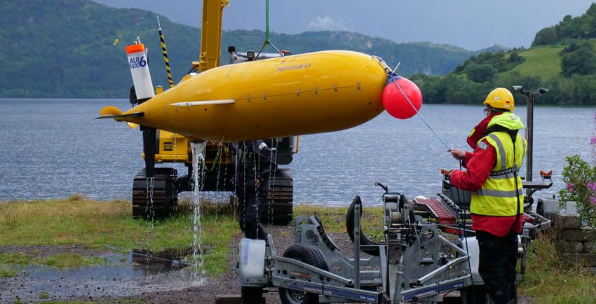
CLIMATE LINKED ATLANTIC SECTOR SCIENCE                                                                                                                     REPORT CARD
CLASS                                                                                                                                                              2021

Fragmentation of sinking particles controls carbon sequestration                                        Up to 21 million tonnes of
                                                                                                        microplastic in Atlantic, and
                                                                                                        hotspots are controlled by
The currents of the MOC supply nutrients that sustain high levels of biological productivity in the     ocean currents
subpolar region, leading to strong biological uptake of carbon by the ocean. CLASS analysis of
biogeochemical Argo float data has revealed that fragmentation of sinking organic particles is the
primary process controlling the rate of deep sequestration of carbon. By breaking into smaller          With the UK leading calls for commitment to
clumps, the particles carry much more carbon to the seafloor than previously thought, explaining up     protecting 30% of the global ocean by 2030,
to 50% of carbon previously unaccounted for in the global carbon budget.                                CLASS research is showing how seafloor
                                                                                                        communities are impacted by natural and
                                                                                                        human disturbances including landslides,
                                                                                                        fishing and plastic pollution. CLASS research
Solving the mysteries of “missing” carbon in the global budget.
                                                                                                        has shown increasing levels of macroplastics
                                                                                                        in the oceans and revealed the highest levels
                                                                                                        of microplastic yet recorded on the seafloor,
                                                                                                        with up to 1.9 million pieces in an area of just
                                                                                                        one square metre. Deep-sea currents act
                                                                                                        as conveyor belts, transporting tiny plastic
                                                                                                        fragments and fibres across the seafloor into
Six decades of change in plankton communities                                                           ‘microplastic hotspots’. CLASS has estimated
                                                                                                        that 12-21 million tonnes of tiny plastic
                                                                                                        fragments are floating in the Atlantic Ocean; a
The Atlantic supports diverse biological communities in the water column and at the seafloor,           much higher amount than previously thought.
and these act as biodiversity reservoirs, underpin the marine food web and supply oxygen to the
atmosphere; in essence they are the ocean’s natural capital. As the environment of the Atlantic ocean
changes, so the ecosystems change in response. Data from the Continuous Plankton Recorder
survey has shown that over the last six decades and 7 million miles of sampling, as temperature has     Results highlight the need for
increased so the makeup of the plankton population found in Britain’s coastal and offshore waters       policy interventions to limit
has dramatically shifted. These changes have consequences for marine biodiversity, climate change
                                                                                                        the future flow of plastics into
(carbon cycling) and food webs including commercial fisheries.
                                                                                                        natural environments and
                                                                                                        minimise impacts on ocean
Evidence of both the growing impacts of climate change and the                                          ecosystems.
mounting human pressures on ocean ecosystems.

04                                                                                                                                                                  05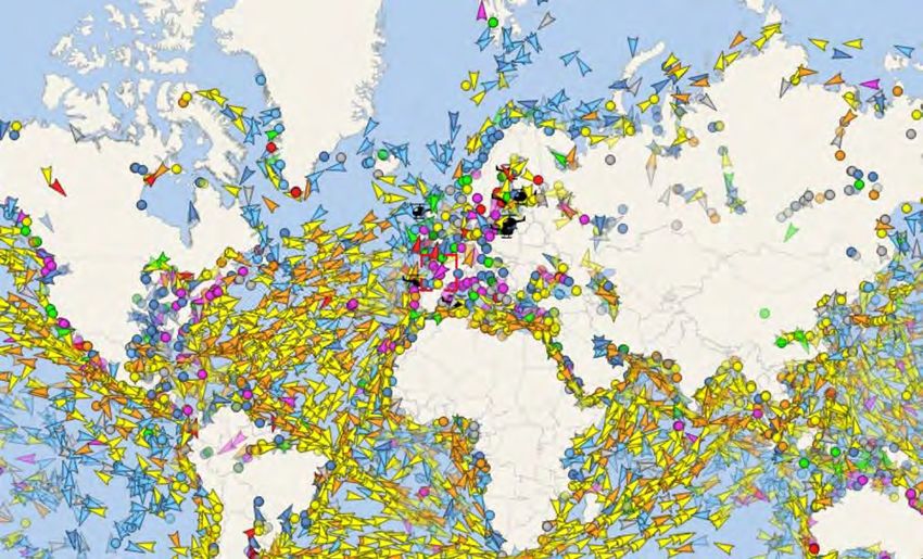
PARTNERSHIPS AND
LEADERSHIP FOR                                                                                                                                                      ENHANCING THE
RESEARCH AND                                                                                                                                                    ACADEMIC RESEARCH
THE GLOBAL OCEAN                                                                                                                                                     ENVIRONMENT
OBSERVING SYSTEM

The CLASS observing system provides high quality coastal to deep ocean, surface to seafloor, physical,     Creating opportunities for early career researchers
biological and chemical data from the Atlantic Ocean. It builds on our historic legacy of many decades
of UK observations, providing unique climate time series information. It is the largest component of the
UK contribution to the international Global Ocean Observing System (GOOS). GOOS provides Essential         CLASS places students and Early Career Researchers (ECRs) from universities around the world on our
Ocean Variables for climate and environmental assessments, operational forecasting needs, and              research expeditions. The ECRs are given the opportunity to develop their skills and collect new samples
climate and earth system research. Through CLASS the UK takes a leading role in the coordination and       and data for their own research. During 2018-2020, we provided berths to 44 students from 18 different
governance of GOOS and its networks, as well as expert groups for intergovernmental organisations          universities, supporting a very wide range of new and innovative research.
such as the World Meteorological Organisation (WMO), the Global Climate Observing System (GCOS)
and the International Council for the Exploration of the Sea (ICES).                                       CLASS has a competitive Fellowship scheme that provides financial support for ECRs to extend their
                                                                                                           research through building on CLASS facilities and expeditions. In 2018-2020 four CLASS Fellowships
CLASS delivers research and knowledge through national and global partnerships with 26 different           were awarded to ECRs from the Universities of Bristol, Manchester and Southampton and the Flanders
universities and 14 research centres. We work closely with UK partners such as the Joint Nature            Marine Institute. Awards supported testing of novel sensors and platforms for monitoring coastal ocean
Conservancy Council (JNCC), the Centre for Environment, Fisheries and Aquaculture Science                  acidification, and the study of the uptake and storage of atmospheric CO2 in the North Atlantic. Two
(CEFAS), the National History Museum, the Royal Navy, and the Met Office. CLASS provides essential         awards have been postponed due to Covid-19: those are for the analysis of NOC sediment cores to study
infrastructure for UK marine science, underpinning 12 NERC research projects, eight European Union         transport and burial of ocean carbon in seafloor sediments, and the optimisation of a novel sensor to
H2020 projects, and 2 European Space Agency projects.                                                      study the role of silicon in the growth and Atlantic phytoplankton.

CLASS is a major contributor to global networks and international                                          In 2020 the Covid-19 pandemic forced CLASS to suspend its early
research, providing scientific and governance leadership as well as
data, facilities and new knowledge                                                                         career researcher schemes; instead we designed a new training
                                                                                                           scheme for developing seagoing leadership skills. From 2021 NERC
                                                                                                           research expeditions will have a Chief Scientist and co-Chief Scientist,
                                                                                                           pairing an ECR with a more experienced researcher. As part of the
                                                                                                           scheme, NERC will hold a competitive, open call for funding three ECRs
                                                                                                           to take up co-Chief Scientist positions each year.

06                                                                                                                                                                                                              07
REPORT CARD
                                                                                                                                                                                                                       2021

                                                                                                                  nutrient data since 2002. Recorded increases in atmospheric CO2 are not mirrored in the sea surface
                                                                                                                  CO2, however increasing variability, particularly in winter is seen. On the UK-Falklands route, where in
                                                                                                                  addition to on board sensor instrumentation, the engineers also take daily samples, five trips were made
                                                                                                                  in 2018-2019 providing sea surface CO2 data and samples for dissolved inorganic carbon (DIC) and total
                                                                                                                  alkalinity (TA) measurements. Data has been used in combination with Integrated Carbon Observation
                                                                                                                  System (ICOS) and Surface Ocean CO2 Atlas (SOCAT) data to understand the processes that affect
                                                                                                                  surface O2 and CO2
OBSERVING SYSTEM
STATUS AND PROGRESS                                                                                               The Continuous Plankton Recorder (CPR) Survey towed 120,000 nm and analysed over 4000 samples
                                                                                                                  in 2018-2019, continuing more than 60 years of uninterrupted monitoring in the North Atlantic. There
                                                                                                                  was no break in the time series in 2020 for core regions despite the Covid-19 pandemic. With a total of
                                                                                                                  7 million nm towed and over 250,000 plankton samples, the CPR datasets are a crucial contribution to
                                                                                                                  assessing biological changes in the Atlantic. The survey capabilities are being expanded beyond the
                                                                                                                  existing biological measurements, such as molecular methods for harmful algal blooms (HABs) and
Measurements from observatories, moorings and ships                                                               marine pathogens. Optical methods are also being developed to speed up and compliment the normal
                                                                                                                  plankton analysis along with new machine learning algorithms to speed up data analysis. Alongside
                                                                                                                  traditional biological sampling, pCO2 sensors have been tested on some CPR routes.
The Atlantic Meridional Transect (AMT) programme has now been running for 20 years, providing
annual measurements on a route between the UK and South Atlantic. During the 2018 and 2019 cruises,               Weekly sampling at the Western Channel Observatory (WCO) was maintained throughout 2020 at
118 conductivity, temperature and depth (CTD) profiles were conducted and 1000s of underway                       both the E1 open shelf station and the L4 coastal station, thanks to the efforts of PML and MBA staff
measurements recorded, covering almost 100° range in latitude. A variety of techniques, sampling and              in adapting to operating during a pandemic. Sampling at E1 started in 1903, making it one of the
measurements were used to determine distribution, abundance and characteristics of phytoplankton,                 longest oceanographic time series in existence. It provides important data to ICOS and contributes to
zooplankton, archaea and bacteria, including net hauls and flow cytometry measurements. This                      publications such as the ICES Report on Ocean Climate.
represents a fraction of the total measurements and data collected; 158 datasets from the 2018 cruise
have already been submitted to the British Oceanographic Data Centre (BODC). The data collected on                While WCO observations in their own right provide important insights into the changing marine
AMT cruises underpin important advances in our understanding of the Atlantic. For example, improved               ecosystem, they are even more powerful when coupled with other datasets. Combining WCO data with
remote satellite sensing techniques resulting from comparison with AMT data, ultimately enabling                  time series from CPR survey transects and coastal/inshore sampling programmes revealed a change
measurements over larger areas and greater time periods without the need for more ships or moorings.              in the state of pelagic habitats across the
                                                                                                                  North-West European shelf. Knowledge about
At the beginning of 2020, the eighth repeat of the 24˚N GO-
                                                                                                                  changes in plankton communities is crucial
SHIP hydrographic section was undertaken on a research
                                                                                                                  to enable policymakers to make effective
cruise from Florida, USA to Tenerife, Spain. During the
                                                                                                                  decisions regarding the management of
cruise, 135 full depth CTD stations were completed along
                                                                                                                  marine ecosystems. Integration of WCO data
the transect, with measurements and sampling for physics
                                                                                                                  with CPR survey data, satellite chlorophyll data
data, carbon, oxygen and nutrients. Data from the cruise has
                                                                                                                  and Celtic Sea sampling data has also allowed
already been cleaned, calibrated and sent to data centres and
                                                                                                                  researchers to determine how nutrient stress
calculations of heat, freshwater and other fluxes, as well as
                                                                                                                  drives food web structure. These combined
decadal changes are in progress. Preliminary processing has
                                                                                                                  datasets, alongside other UK plankton
already revealed significant results in that the upper ocean
                                                                                                                  datasets are also being used in the UK Marine
part of the 24.5˚N section has become warmer, saltier and
                                                                                                                  Strategy and, via the OSPAR Commission, in
higher in carbon over the last 10 years.
                                                                                                                  the EU Marine Framework Strategic Directive.

CLASS supported the UK-Caribbean SOOP (Ships of
                                                                                                                  A major objective for CLASS are cruises to
Opportunity) route in 2018-2019. The GEEST Line route has       Route of the Atlantic Meridional Transect (AMT)                                                       Difference between 2020 and 2010 temperature measurements from
                                                                                                                  maintain the Ellett Array moorings; these
been providing sea surface CO2, temperature, salinity and       shown on a map of sea surface temperature (SST)                                                       the GO-SHIP programme showing upper ocean warming

08                                                                                                                                                                                                                              09
CLIMATE LINKED ATLANTIC SECTOR SCIENCE REPORT CARD
CLASS 2021
took place successfully in July 2018 For example, evidence of increased activity
and October 2020. Continuous in some deep-sea deposit feeders seen via
measurements (10-day means) of Bathysnap, a time lapse camera deployed
ocean volume, temperature and on the seafloor, can be linked to seasonal
salinity transports through the fluctuations in phytodetritus input measured in
Rockall trough were delivered. water column sediment traps.
The data has been analysed and
a paper on the variability of the The South Atlantic Tidal Gauge Network
North Atlantic current through the (SATGN) was established in 1985. It provides
Rockall trough has been published, an important time series of sea level, water
revealing a large variability in the temperature and air pressure which is crucial
eastern North Atlantic circulation to understanding sea level variability and WCO observations showing definite shifts in abundance of different
zooplankton species over time
due to changes in the North Atlantic ocean current fluctuations (particularly the
Continuous Plankton Recorder (CPR) North Atlantic Routes (historical and current)
Current. This continuous time series Antarctic Circumpolar Current) and to enable
is also allowing new types of analysis and revealing, for example, seasonal signals with much greater ‘ground truthing’ of satellite altimetry. In addition this data allows evaluation of storm surges and tides,
significance than was previously detectable. The data has been submitted to BODC as well as provided vital for e.g. coastal protection and port operations. Work has focused on the refurbishment of the tidal
to the OSNAP (Overturning in the Subpolar North Atlantic Program) International Data Working Group gauges to replace worn out or damaged components and upgrade sensors.
where CLASS researchers are contributing authors to forthcoming publications.
Summer and winter glider missions have been conducted, aiming to increase the spatial coverage of the
Ellett Array moorings. In consultation with OSNAP, the sampling strategy has been changed to measure
the shelf edge current. This is a significant pathway for Atlantic MOC transport but has proved impossible
to measure using moorings due to the intensity of fishing activity. Work has focussed on determining
whether gliders can accurately assess transport and on mitigating the risks of surface collision or
entanglement with fishing nets.
The Porcupine Abyssal Plain Sustained Observatory (PAP-SO) is the UK’s open ocean ICOS station.
The time series data for sea surface CO2, pH, benthic biota and many other parameters has continued
under CLASS, delivered through a combination of surface and subsurface instruments and sensors,
deep sediment traps and seabed cameras.
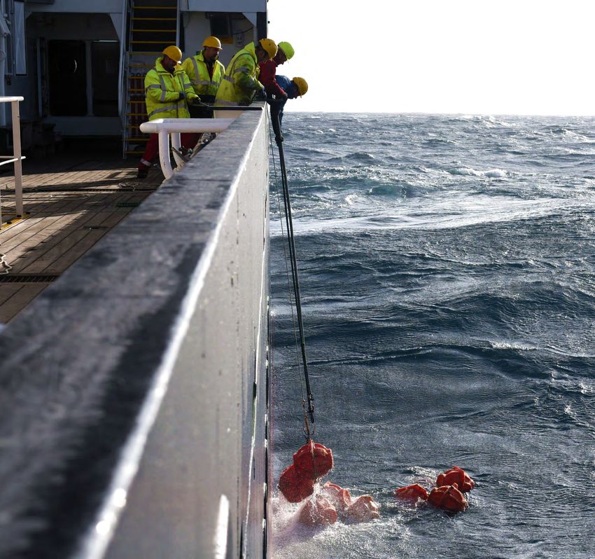
Major objectives for this period of CLASS
were cruises in both 2018 and 2019 to service An example of a time series from PAP-SO
the mooring and instruments and to conduct
sampling and surveys. Data from both cruises
have been submitted to BODC with CO2 CLASS brings together several long term programmes to form an
related data also submitted to ICOS and
extensive Atlantic Ocean observing system. The combination of ship
SOCAT.
based measurements from repeat transects with data from floats and
The combination of long term physical, fixed instrumentation (moorings, observatories, tidal gauges) provides
biogeochemical and biological time series
a comprehensive set of data for evaluating the impact of climate
data from PAP provides a powerful tool in
understanding the changes occurring in the change on the Atlantic ecosystem. This in turn provides key evidence
Atlantic, allowing the linking of surface water, for policy advice related to our use and protection of the oceans.
4 year time series of transport from Ellett array mooring measurements
water column and deep ocean processes. illustrating variability of the North Atlantic current in the Rockall Trough
10 11
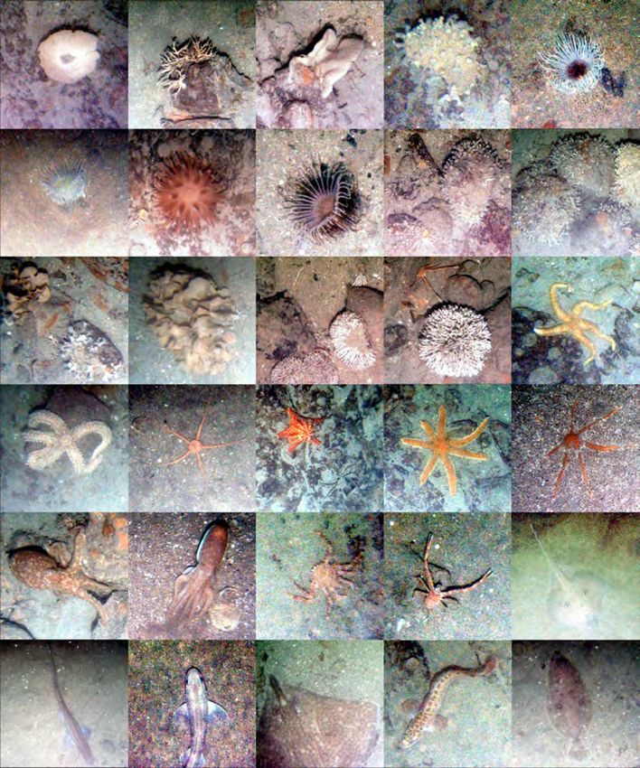
CLIMATE LINKED ATLANTIC SECTOR SCIENCE                                                                                                                                                                       REPORT CARD
CLASS                                                                                                                                                                                                                2021

Assessing human impact in the marine environment

A crucial tool in assessing the impact of
human activity in the marine environment,
and distinguishing between natural and
anthropogenic influences, is the use of repeat
surveys and monitoring at specific sites. The
intent of CLASS in the first half of the project
was to conduct fieldwork at two key sites, the
Haig Fras Marine Conservation Zone (MCZ)
and the Darwin Mounds.

Haig Fras MCZ, the only rocky reef in the           Fishing nets snagged on corals at the Darwin mounds

Celtic Sea, was surveyed using the Autosub
autonomous underwater vehicle (AUV) in 2018 to obtain acoustic (sidescan sonar) and image data. This
adds to the 2012 and 2015 surveys and expanded the study of this area with a comparison of daytime
and night-time benthic communities. Image analysis from these surveys has shown distinct benthic
communities on different seafloor substratum. The sidescan data and machine learning techniques have
been used to map where these communities occur and then show the changes of habitat over time.

The Darwin Mounds were re-mapped in 2019 (adding to the first mapping data in 1998-2000 and repeat
mapping in 2011) using Autosub6000 to conduct six sidescan sonar and BioCam photography surveys.
HyBIS video transects were also conducted, sediment samples collected and settlement experiments
recovered. There was little change in the morphology of the mounds and no new trawl marks were
discovered but there were considerable amounts of litter, especially fishing equipment. Analysis is
ongoing, including a ‘human vs computer’ test to see whether machine learning technology or humans
are quickest at estimating the amount of coral cover in images.

Whittard Canyon and the Canyons Marine Conservation Zone were due to be revisited in 2020 to conduct
fieldwork and repeat surveys. The suspension of the cruise program due to Covid-19 means that this has
been postponed until at least 2021. However the collaborative power of the CLASS program enabled a
mooring to be deployed during one of the PAP cruises in 2019 and some work to be completed during
the Haig Fras cruise. This included remotely operated vehicle (ROV) video surveys along with sampling
of specimens and sediments, and AUV acoustic and image data. The mooring will also be recovered,
serviced and redeployed during the next PAP cruise.

Although mapping of the Darwin Mounds did not find evidence of
new coral growth, settlement experiments show that there are coral
larvae in the area and therefore the potential for new cold-water                                         Images of benthic invertebrates and demersal fish at Haig Fras MCZ, taken by AUV mounted cameras

coral colonies exists.

12                                                                                                                                                                                                                     13

CLIMATE LINKED ATLANTIC SECTOR SCIENCE
CLASS

Essential novel datasets for characterising climate change

A new data set (CLASSnmat) has been developed that provides monthly mean, gridded values of Night
Marine Air Temperature back to 1880 across global ocean regions. CLASSnmat complements the more
widely used sea-surface temperature datasets as an indicator of global temperature change and serves
as a reference dataset for the evaluation of reanalysis and modelled data.                                                                                                            OCEAN AND CLIMATE
                                                                                                                                                                                      PREDICTIVE SYSTEMS
The CLASS global upper ocean heat content product (derived from Argo float data) contributed to a                                                                                         DEVELOPMENTS
new, international review of Earth’s energy imbalance. The oceans continue to absorb more than 90%
of global warming heat. The analysis will play a central role in informing and advising policy through the                                                                                    AND IMPACT
Intergovernmental Panel on Climate Change (IPCC) and other channels. NOC has been requested to run
a special update of the product to inform a WMO statement on climate.

                                                                                                                              Key global model configurations underpinning the UK’s capability in
                                                                                                                              ocean prediction for climate change and operational oceanography

                                                                                                                              CLASS scientists improve the representation of physical processes in the NEMO ocean-ice model and
                            0.5
Temperature Anomaly (°C)

                                                                                                                              enhance its computational efficiency through NOC’s membership of the international NEMO Consortium.
                                                                                                                              We construct rigorously tested global model configurations for UK prediction systems (weather
                                                                                                                              forecasting, including short term ocean “weather” forecasts, seasonal/decadal climate predictions, and
                                                                                                                              century-scale climate projections). These configurations are delivered in collaboration with the Met Office
                            0.0                                                                                               and UK academic research institutions via the Joint Marine Modelling Programme (JMMP).

                                                                                                                              NEMO’s computational efficiency has been significantly enhanced by improving treatment of model grid
                                                                                                                              points that lie at the boundaries of the individual computer processors and large portions of the code
                                                                                                                              have been rewritten to accommodate a new more accurate time-stepping scheme. A major improvement
                           −0.5                                                                                               to the physics is the inclusion of a more realistic treatment of sea ice deformation and flow, break up via
                                                                                                                              wave-ice interaction, and surface melt ponds.

                                                                                                                              The next configuration of NEMO for use in UK forecasting systems is GO8 (Global Ocean configuration
                                  1880                           1920                             1960               2000     #8), developed with the Met Office through JMMP. This has been extensively tested under CLASS and
                                                                                         Year                                 features a new sea ice scheme, SI3; reduced spurious numerical mixing due to inclusion of a more
                                                                                                                              accurate advection scheme; a new equation of state based on latest theory and observations; and we are
                                                                                                                              in the process of adding a new cutting edge ocean surface boundary layer scheme (OSMOSIS). For the
                                                      HadSST4                HadNMAT2                 UAHNMAT     CLASSnmat
                                                                                                                              subsequent configuration, GO9, we are developing a new approach to modelling overflows of deep water
                                                                                                                              masses through critical sills such as the Denmark Strait and the Greenland-Scotland ridge.

Global temperature anomalies from new CLASSnmat dataset compared to previous datasets of sea surface and
night marine air temperatures                                                                                                 The MEDUSA model, a marine biogeochemistry component used in the global models, has been
                                                                                                                              improved with dynamic C:N stoichiometry which removes potential errors in future C-cycle fluxes that can
HadSST4 		                           Met Office Hadley Centre sea surface temperature dataset
HadNMAT2                             Met Office Hadley Centre and NOC night-time marine air temperature dataset               arise from fixed stoichiometry. The benthic ecosystem is represented more accurately to capture the full
UAHNMAT                              University of Alabama night-time marine air temperature dataset
                                                                                                                              seafloor ecosystem from bacteria to fish using BORIS, a benthic biomass model.

14                                                                                                                                                                                                                                     15
CLIMATE LINKED ATLANTIC SECTOR SCIENCE REPORT CARD
CLASS 2021
Key shelf sea model configurations underpinning the UK’s capability Global and regional simulations to investigate the impacts of climate
in shelf sea prediction for NW European waters and beyond change on the marine environment
The Atlantic Margin Model (AMM) vertical coordinate set up has been ACSIS Model simulations provide valuable data in studying the influence of climate change on the marine
North Atlantic Climate System
revised to give better results on shelf slopes where there is very steep environment and ecosystems. Understanding potential impacts enables mitigation measures to be
Integrated Study
topography, (to minimise, for example, horizontal pressure gradient errors). put in place and appropriate management of e.g. coastal areas, fisheries and Marine Conservation
BORIS
Wetting and drying processes (representing a mobile coastal water line) and Benthic Organisms Resolved Zones. Simulations can also be used to test observation strategies, enabling better targeting of
in Size
improved Baltic boundary conditions have also been incorporated. resources, or to put limited observations into a longer term context. For example, a relationship
COAsT
observed in the first years of the OSNAP array suggested that the much of the variability of the sub
Coastal Ocean Assessment
The ERSEM ecosystem model code (ERSEM 20.10) has been publicly Toolbox polar meridional overturning circulation was found in the eastern part of the North Atlantic while the
released, including harmonised formulations, and updated documentation. ERSEM western part played a much lesser role. This was also observed in modelling but over a longer time
European Regional Seas
There are upwards of 280 registered users worldwide. In the AMM7 model period suggesting this was not just short term feature.
Ecosystem Model
we have improved the definition of river inputs and boundary conditions.
FABM
The flexible coupling of external model systems to ERSEM via FABM is Framework for Aquatic CLASS has completed two coupled model simulations in collaboration with the ACSIS and PRIMAVERA
Biogeochemical Model
advancing, for example a model suite that uses PyLag particle tracking, projects and work is now well underway to complete coupled ORCA12-MEDUSA simulations. These
(Connects a hydrodynamic
ShellSim for aquaculture, embedded in ERSEM with physics driven by model with multiple simulations will run to the end of this century at increasing resolutions. Analysis of simulations at different
biogeochemical models)
FVCOM is being used to examine the impacts and interactions between resolutions can reveal processes that might not be apparent from only one simulation.
FVCOM
microplastics and mussel culture.
Finite Volume Community Ocean
Model
(Provides 3D simulations of
New functionality has been added to COAsT, a tool for examining
ocean’s physical properties)
kilometric scale regional models. For example, arbitary vertical slices
MEDUSA
can be selected and the properties (e.g. velocities, transports) of Model of Ecosystem Dynamics,
nutrient Utilisation, Sequestration
these sections can be plotted. This facilitates the comparison between
and Acidification
observations and model simulations in order to assess to model
NEMO
performance. Nucleus for European Modelling
of the Ocean (A modelling
framework developed by a
European consortium for
ORCA12-MEDUSA simulations at increasing resolution showing biological production
research and forecasting in
ocean and climate sciences)
ORCA
(A series of global ocean
configurations used when
running some models)
Ocean modelling work does not happen in isolation over the space
OSMOSIS
Ocean Surface Mixing, Ocean of a couple of years! The work in CLASS feeds into a vast array of
Sub-mesoscale Interaction Study
PRIMAVERA
other projects and programmes, however it is also the product of
PRocess-based climate
sIMulation: AdVances in
decades of underpinning work.
high resolution modelling
and European climate Risk
Assessment (European Union
funded project)
PyLag
A Python Lagrangian particle
tracking framework
ShellSIM
Model that simulates shellfish
PML’s coupled marine system growth and population dynamics
16 17REPORT CARD
2021
Power and communications
To fully capitalise on sensor technologies and platforms, improved power and communications are
vital as these will enable longer uninterrupted time series, fewer site visits and immediate access to
data. CLASS is investigating energy harvesting and more efficient data transfer to avoid reliance on
ENHANCEMENTS IN increasing numbers of batteries.
CHARACTERISING OUR
CHANGING OCEAN A prototype wave energy harvesting system and a supercapacitor storage prototype (for wave
and solar energy) have been shown to work in the laboratory and will be tested in the field shortly.
THROUGH INNOVATION Demonstration of CTD sampling driven by wave energy has shown promise but will require adaptive
sampling based on power availability.
Data transfer using the Satellite Automatic Information System
Chemical and biological sensor development (S-AIS) allows small bursts of data to be sent from AIS
transponders and relayed via satellite at a fraction of the cost
of the Iridium network. There are no transmission limits and it
In situ lab-on-chip sensors for measurement of the can be powered by harvested or renewable energy. However,
ocean carbonate system have been successfully transmitting VHF signals via satellite is complex; not every
deployed in a range of environments on various message sent is guaranteed to be received. Work is ongoing to
platforms. As part of an offshore CO2 release investigate transmission success rates and patterns to ensure Supercapacitor energy storage – electronics are
experiment, total alkalinity (TA) and pH sensors were optimum data transfer. being developed to manage the energy store
used on landers and ROVs, while trials in Loch Ness
allowed testing on an AUV. The deep ocean capability
of the pH sensor was proven during a cruise to the PAP
observatory site with several successful deep (~4820m)
deployments. Further improvement of the sensors is
ongoing with integration of TA and dissolved inorganic
pH lab on chip sensor mounted on CTD frame during
carbon (DIC) sensors onto a single device to increase deployment at the PAP site
performance and reduce power usage.
Biological sensor development includes RoCSI (Robotic
Cartridge Sampling Instrument), an autonomous
particle sampler to target microbiology and eDNA,
Cytochip, a microcytometer for shallow water work, and
Amplitron, an in situ genomic analyser (DNA and RNA
detection). RoCSI has been completely redesigned
and is undergoing extensive bench testing prior to
deployments at the Western Channel Observatory
and on an AUV at ~3000m. The benchtop version of
Cytochip is operational; unique cytometric profiles
have been generated for harmful algal blooms (HABs).
The next step is a redesign to improve portability and
AutoSub Long Range (ALR) with total Alkalinity and pH lab on The AIS (automatic identification system) is an automatic tracking system that uses transceivers on
robustness for in situ deployments. chip sensors ships, plot shows snapshot of global marine traffic
18 19CLIMATE LINKED ATLANTIC SECTOR SCIENCE
CLASS
Novel remote and autonomous platforms Impacts of COVID-19
Measurements of air-sea interactions from oceanographic research vessels can be contaminated by the CLASS has of course not been immune to the impacts
presence of the vessel itself. For example, disruption of wind flow around the vessel can cause turbulent of Covid-19. The most obvious consequence was the
fluxes, and the shadow of the vessel can affect observed scattered light. While modelling allows some suspension of the National Marine Facilities cruise
correction of these effects, a better solution is to use remotely piloted aircraft systems (RPAS) and programme in March 2020. This affected two major
autonomous surface vehicles (ASVs) away from the ship. CLASS cruises originally scheduled for the summer to
carry out operations at Ellett Array (Rockall Trough), the
In this phase of the CLASS project, RPAS and ASVs have been successfully deployed from shore and Darwin Mounds and Whittard Canyon Marine Protected
ship. An acoustic weather station deployed on an ImpYak, a robotic impeller driven kayak, has been used Areas (MPA), and the Porcupine Abyssal Plain (PAP).
to obtain near surface meteorology, and an Acoustic Doppler Current Profiler (ADCP) mounted through- The cruise programme resumed in September 2020
hull was also used to obtain upper level ocean velocity profiles. Geo-stationary capability of the ImpYak and both expeditions were completed successfully,
has been proven. albeit with reduced numbers of scientists on board
and a necessarily reduced scientific programme. The
Water landable RPAS have been used to successfully measure upper-boundary-layer winds. The impacts of Covid-19 on the cruise programme are likely
measurements are derived from the full onboard avionics instrumentation which enable accurate to continue for the foreseeable future, with pressure on
determination of velocity, position and altitude. Fieldwork was restricted in 2020 due to Covid-19 but available ship time affecting CLASS into 2021 and 2022.
further testing of the systems is already underway including mapping in conjunction with modelling to
compare results. Inevitably, the delays to fieldwork and loss of
productivity due to laboratory and office closures,
will have a knock on effect to the completion of some
CLASS deliverables. However, risks to the programme
Increasing use of in situ and remote technologies to provide
are being closely monitored and the CLASS participants
measurements and monitoring of the Atlantic Ocean is vital if we are have all worked hard to adapt to the circumstances and
to fully understand this ecosystem and our impact on it, without also minimise disruption to the science programme.
inadvertently impacting it ourselves. Ship-based measurements will
always have their place and access to ocean observatories for servicing
will be needed. However, in situ and remote technologies can provide
measurements over much larger areas and on much longer timescales
and in areas that would otherwise be inaccessible due to geography
(e.g. under sea ice) or weather conditions.
20 21projects.noc.ac.uk/class
You can also read