Concept of Operations 2023 - version 2.0 New Zealand - New Southern Sky
←
→
Page content transcription
If your browser does not render page correctly, please read the page content below

Concept New
         ofZealand
             Operations
         2023
        version 2.0

                          1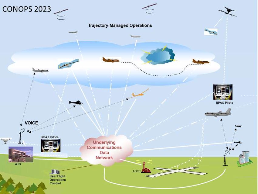
New Southern Sky

Level 15, 55 Featherston Street
P O Box 3555, Wellington, New Zealand
T +64 4 560 9400
F +64 4 560 2024
E nss@caa.govt.nz
www.nss.govt.nz

Cover Image

NASA/astronaut Ron Garan ISS027-E-012395 (13 April 2011)

References

ICAO Doc 9613 4th Edition
National Airspace and Air Navigation Plan
Civil Aviation Rules
Aviation System Safety Criteria, Prepared for CAA by Navigatus Consulting, 15 April 2016
The National Airspace Policy of New Zealand (2012)
Connecting New Zealand, a policy transport paper (2011)
GNSS Sole Means Recommendation Report - Prepared for the New Southern Sky Working Group,
Governance Group and DCA dated 16 November 2015
National Strategy for Flight Training, NSS, Aviation New Zealand, April 2016
Ground Based Navigation Aid Strategy, November 2016
New Zealand PBN Implementation Plan – Revised 2017
New Zealand PBCS Implementation Plan (2018)
GBNA Report and Recommendations, 26 April 2018

Issued by:
Mr Steve Smyth
Director New Southern Sky
Civil Aviation Authority
On behalf of the New Southern Sky Working Group

CROWN COPYRIGHT ©

This work is licensed under the Creative Commons Attribution 3.0 New Zealand licence. In essence
you are free to copy distribute and adapt the work as long as you attribute the work to the Crown
and abide by the other licence terms.

To view a copy of this licence, visit http://creativecommons.org/licenses/by/3.0/nz/. Please note that
no departmental or governmental emblem, logo or Coat of Arms may be used in any way which
infringes any provision of the Flags, Emblems, and Names Protection Act 1981. Attribution to the
Crown should be in written form and not by reproduction of any such emblem, logo or Coat of Arms

                                                                                                     2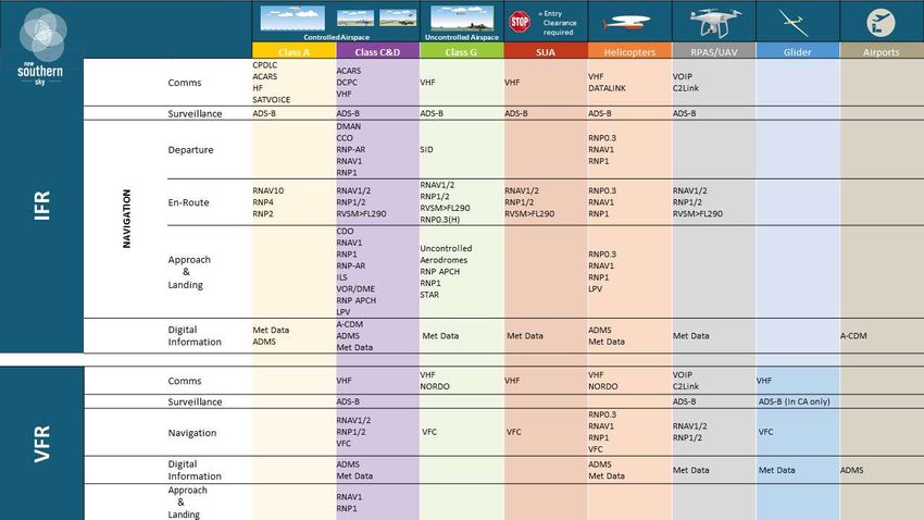
Contents
          Executive Summary................................................................. 9

          Introduction ........................................................................... 11

          Assumptions .......................................................................... 13

          GNSS/PBN Conditions .......................................................... 14

          The Changing Nature of the Industry ................................... 15

          System Component Overview .............................................. 17

          Information Management ...................................................... 25

          Layers of Airspace Use ......................................................... 30

          Appendix 1: System Component Overview Transition ....... 46

          Appendix 2: SBAS ................................................................. 50

          Appendix 3: Definitions ........................................................ 51

                                                                                                           3
Version
2.0                                                                                 New Southern Sky - CONOPS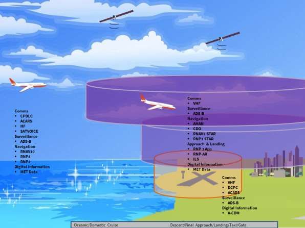
List of Figures
Figure 1: CONOPS 2023................................................................................................ 10
Figure 2: System Wide Information Management ...................................................... 26
Figure 3: Current communication network ................................................................. 27
Figure 4: NSS communication network ....................................................................... 27
Figure 5: PBN Specifications ........................................................................................ 30
Figure 6: Above FL245 Controlled Airspace ................................................................. 31
Figure 7: Mid-Level FL130-245 Controlled Airspace .................................................... 32
Figure 8: Oceanic arrival Controlled Airspace.............................................................. 33
Figure 9: Low Level IFR and VFR Controlled Airspace Below FL130 ............................ 34
Figure 10: Helicopter Operations Controlled Airspace ................................................ 36
Figure 11: Helicopter Operations Low Level and Uncontrolled Airspace .................... 38
Figure 12: Unmanned Aircraft Operations Controlled Airspace.................................. 40
Figure 13: VFR Operations Uncontrolled Airspace ...................................................... 41
Figure 14: Airport CDM ................................................................................................ 42
Figure 15: CONOPS 2023.............................................................................................. 44

List of Tables
Table 1: Programme Stages ......................................................................................... 17

                                                                                                                        4
Version
2.0                                                                                     New Southern Sky - CONOPS
List of Acronyms

 Acronym           Term

 ACE               Airport Capacity Enhancement

 A-CDM             Airport Collaborative Decision Making

 ADS-B             Automatic Dependent Surveillance - Broadcast

 ADS-C             Automatic Dependent Surveillance - Contract

 AFTN              Aeronautical Fixed Telecommunication Network

 AIM               Aeronautical Information Management

 AIP               Aeronautical Information Publication

 AIS               Aeronautical Information Services

 AIXM              Aeronautical Information Exchange Model

 AMAN              Arrivals Manager

 AMHS              ATS Message Handling System

 ANSP              Air Navigation Service Provider

 APCH              Approach

 ATC               Air Traffic Control – a sub-function of Air Traffic Service

 ATM               Air Traffic Management

 ATN               Aeronautical Telecommunication Network

 ATS               Air Traffic Service – a sub-function of Air Traffic Management

 Baro VNAV         Barometrical Vertical Navigation

 BeiDou            China Global Navigation Satellite System, not yet fully operational

 CAA               NZ Civil Aviation Authority.

 CA                Controlled Airspace

 CCO               Continuous Climb Operations

 CDM               Collaborative Decision Making

 CDO               Continuous Descent Operations

 CONOPS            Concept of Operations

 CPDC              Controller Pilot Digital Communication

 CPDLC             Controller Pilot Data Link Communications

 DME               Distance Measuring Equipment

 FAA               Federal Aviation Administration

 FIR               Flight Information Region

 FL                Flight Level

                                                                                         5
Version 2.0
         New Southern Sky - CONOPS
Acronym           Term

 FTO               Flight Training Organisation

 GA                General Aviation

 Galileo           European Global Navigation Satellite System, not yet operational

 GBNA              Ground Based Navigation Aid
                   Globalnaya Navigazionnaya Sputnikovaya Sistema. Russian Global Navigation
 GLONASS
                   Satellite System
 GNSS              Global Navigation Satellite System

 GPS               Global Positioning System

 HEMS              Helicopter Emergency Medical Service

 HF                High Frequency

 ICAO              International Civil Aviation Organisation

 IFR               Instrument Flight Rules

 ILS               Instrument Landing System

 IRU               Inertial Reference Unit

 ITS               Intelligent Transport System

 IWXXM             ICAO Weather Exchange Model

 LPV               Localizer Performance with Vertical Guidance

 MET               Meteorological

 MON               Minimum Operational Network

 MoT               Ministry of Transport
                   Multi-Functional Transport Satellite Augmentation System, MSAS-MTSAT,
 MSAS
                   Japan
 NAANP             National Airspace and Air Navigation Plan

 NAVAIDS           Navigation Aids

 NM                Nautical Mile

 NSS               New Southern Sky programme

 PB                Performance Based

 PBCS              Performance Based Communications and Surveillance
 PBN               Performance Based Navigation
 PBN Manual        Performance Based Navigation Manual, ICAO Doc 9613 4th Edition

 PinS              Point in Space

 RAIM              Receiver Autonomous Integrity Monitoring

 RCP               Required Communication Performance

 RLP               Required Link Performance

                                                                                               6
Version 2.0
         New Southern Sky - CONOPS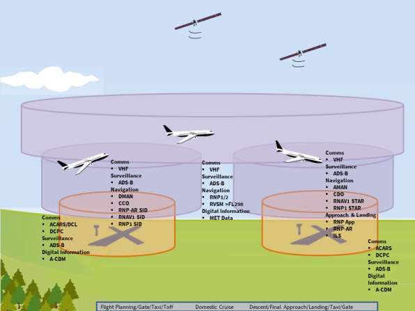
Acronym           Term

 RPT               Regular Passenger Transport

 RNAV              Area Navigation

 RNP               Required Navigation Performance

 RNP-AR            Required Navigation Performance – Authorisation Required

 RSP               Required Surveillance Performance

 RWY               Runway

 SATCOM            Satellite Communication

 SATVOICE          Satellite Voice Communication

 SARPs             ICAO Standards and Recommended Practices

 SBAS              Satellite Based Augmentation System

 SID               Standard Instrument Departure

 SOA               Service Oriented Architecture

 SSR               Secondary Surveillance Radar

 STAR              Standard Terminal Arrival Route

 SUA               Special Use Airspace

 SWIM              System Wide Information Management
                   Traffic Collision Avoidance System [Traffic Alert and Collision Avoidance
 TCAS
                   System]
 Unmanned
                   Previously Remotely Piloted Aircraft System (RPAS)
 Aircraft
                   Unmanned Traffic Management [Unmanned Aircraft System Traffic
 UTM
                   Management]
 VFR               Visual Flight Rules

 VHF               Very High Frequency

 VMC               Visual Meteorological Conditions

 VNAV              Vertical Navigation

 VoIP              Voice Over Internet Protocol

 VOR               VHF Omnidirectional Range. Ground based navigation aid

                                                                                               7
Version 2.0
         New Southern Sky - CONOPS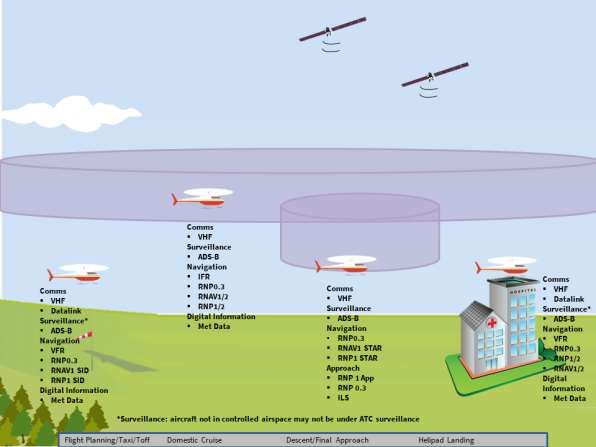
CONOPS Review
 Revision               Date               Authorised By

                                           Name                 Signature

 Issue 1                6 July 2016        Steve Smyth

 Issue 2                17 October 2018    Steve Smyth

 Issue 3

 Issue 4

 Issue 5

The intention is for this CONOPS document to be reviewed and updated, as needed, to
keep pace with the changes to the New Zealand aviation system being introduced through
NSS.
This is a living document and this is version two. It is intended that it will be updated
continually as further work matures and can be incorporated. This version of the CONOPS
reflects the Global Navigation Satellite System (GNSS) work, the Ground Based Navigation
Aid (GBNA) Infrastructure Strategy paper, PBN Implementation Plan Revised 2017 New
Zealand Version 2.1.

                                                                                            8
Version 2.0
         New Southern Sky - CONOPS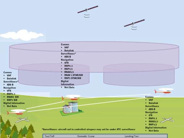
New Southern Sky
Concept of Operations

Executive Summary
1.    This document, the Concept of Operations (CONOPS) is a description of how a set of
      capabilities may be employed to operate in New Zealand’s domestic airspace in 2023.
      The CONOPS is aligned with the National Airspace and Air Navigation Plan1 (NAANP).
      The CONOPS is a collaborative document, produced with input from the stakeholders
      that have taken guidance from the NAANP, Global Navigation Satellite System Sole
      Means Report, Ground Based Navigation Aid Minimum Operating Network, and used
      it to provide a reference framework for the New Southern Sky (NSS) programme end
      state. The CONOPS models today’s view of the airspace in the New Zealand Flight
      Information Region (FIR) aviation system 2023. Aviation industry input enables a
      segmented view, by operations type, of this system.
2.    A wide spectrum of New Zealand’s aviation industry operates throughout the FIR
      airspace. At one end of the spectrum are international flights entering or departing
      the FIR, there are domestic jet operations in airspace above FL245, medium level
      Regular Passenger Transport (RPT) operations between FL130 to FL245 and lower
      level operations through to FL130. Military and Corporate aircraft operate
      throughout this airspace range. General Aviation (GA) and helicopters operate mainly
      in the airspace below FL130.
3.    The scenarios provide a detailed stakeholder view of how these airspace layers will be
      flown by operators and the capabilities they will employ for optimum efficiency and
      safety.
4.    By 2023, the New Zealand FIR will see greater use of digital data, providing a rich
      environment for information dissemination to aviation systems users. Optimal use of
      airspace will be achieved through suitably equipped aircraft operating in this
      airspace. This technology transition will be flexible, enabling growth in aircraft
      movements through the FIR and be able to accommodate aircraft with different
      capabilities.

1 New Southern Sky, National Airspace and Air Navigation Plan, June 2014

                                                                                           9
Version 2.0
         New Southern Sky - CONOPS
5.    The design will be unique to New Zealand, providing operationally ready airspace.
6.    This CONOPS articulates what the NSS Programme will deliver to the New Zealand
      aviation system. Ultimately it will be enabled through appropriate policy, regulations,
      where needed, and users deploying the appropriate equipment. The CONOPS adds
      to the NSS strategy and objective outcomes work programme. It should be noted
      where proposed change refers to policy decisions yet to be made, the content herein
      should be taken as a vision of the future, rather than a statement of what will
      happen.
7.    Aviation Infrastructure is integral to the New Zealand transport system and economy.
      The transition to a Performance Based Navigation (PBN) environment will be integral
      to the 'Intelligent Transport System' strategy of the Ministry of Transport and in
      addition, the introduction of PBN enabled airspace nationally enhances the safer
      journeys concept.
8.    As policy, regulations, collaborations, and technology develop, the concept will be
      continually reviewed to keep pace with these changes.
                                     Figure 1: CONOPS 2023

                                                                                            10
Version 2.0
         New Southern Sky - CONOPS
Introduction
9. This CONOPS document is a description of how a set of capabilities may be employed
to operate in New Zealand’s domestic airspace in 2023. The CONOPS is aligned with
the NAANP, PBN Implementation Plan (Revised 2017), Global Navigation Satellite
System (GNSS) Sole Means ‘conditions’ work and the New Zealand Ground Based
Navigation Aid (GBNA) Infrastructure Strategy.
A Concept of Operations is a document describing the characteristics of a proposed
system from the viewpoint of an individual who will use that system. It is used to
communicate the quantitative and qualitative system characteristics to all
stakeholders.
10. The CONOPS is a collaborative document, produced with input from the stakeholders
and is used to provide a reference framework for the NSS programme end state.
11. There have been significant advances in technology that allow information derived
from digital and satellite data to be integrated into aviation system wide activity to
provide significant increases in safety, efficiency, and reliability.
The aim of the CONOPS is:
To provide an agreed stakeholder view of the New Zealand aviation system and how
it will operate in 2023.
The objectives of the CONOPS are:
To articulate the NSS ‘target concept’ in terms of a system.
To incorporate NSS System Safety Criteria as the foundation of a safe system
approach.
To incorporate agreed assumptions as the foundation of a recognised system
approach.
To provide an understanding of how stakeholders expect to conduct safe and
effective operations within the environment prescribed by the PBN Implementation
Plan (Revised 2017), GNSS Sole Means ‘conditions’ work, and the New Zealand
GBNA Infrastructure Strategy.
To provide stakeholder business planning alignment and coordinated decision
making at all levels.
To step beyond the component proposals of the NAANP and provide an agreed
stakeholder view of the 2023 ‘system end state’.
Identify areas/functions of the aviation system requiring further development,
especially as incremental changes towards 2023 identify new areas in need of
review.
11
Version 2.0
New Southern Sky - CONOPSWe are changing the way we operate so that the aviation industry can
achieve economic growth through efficiency gains
12. Change is being driven via a global model developed at ICAO, this will be refined and
modelled for the local region to meet international safety standards and best
practices, this will also contribute to economic growth through efficiency gains’2.
Benefits increase as more industry stakeholders make strategic choices to engage in
the process of change, to implement new technologies or to refine procedures.
13. We therefore need to contextualise and explain how that looks from a system
perspective.
Without compromising safety, we aim for efficient, environmentally
responsible, integrated and interoperable systems
14. These attributes will be enabled, if not solely delivered, by the ability to dynamically
manage aircraft through:
a. Integrated communications data to information networks.
b. Integrated scheduling and flight planning.
c. Enhanced surface operations.
d. Streamlined departure management.
e. Efficient cruise.
f. Streamlined arrival management.
g. Airport surface capacity enhancement.
15. There is a cohesive relationship between all elements of the attributes sought and
the delivery mechanisms. To ensure reasonable ongoing support for the GA
community, ongoing service will be provided to operators with compliant equipage.
Trajectory management is key to safety and efficiency
16. New trajectory management tools will enable controllers to safely manage potential
conflicts and provide increased efficiencies across the network to the benefit of all
users of the airspace.
17. The trajectory management of aircraft will enable the new operating environment to
manage an aircraft’s profile from departure gate to arrival gate, including both civil
and military operations. This environment will be achieved through greater strategic
integration and coordination of ATM to enable efficient aircraft operations.
2New Zealand’s National Airspace Policy seeks ‘a safe and capable airspace and air navigation system both
within New Zealand and the international airspace it manages, that aligns to international safety standards
and best practices, and contributes to economic growth through efficiency gains’
12
Version 2.0
New Southern Sky - CONOPS18. The implementation of NSS enables optimisation of capacity in New Zealand
airspace.3
Assumptions
19. A number of assumptions have been applied to both the development of safety
criteria and this CONOPS. Key assumptions are:
a. The current aviation system is safe.
b. A GBNA network will be in place to support Recovery and Contingency operations
and will be known as the Minimum Operational Network (MON).
c. The MON will be able to support all operational IFR requirements within the
NZFIR, which needs to be enabled by appropriate safety analysis and rule
development.
d. It continues to be the operator’s responsibility to assess their operations against
PBN requirements, including the safe recovery of aircraft in the event of the loss
of navigation capability.
e. An aircraft with an approved RNAV capability based on GBNA (DME/DME and
DME/DME/IRU) may be able to continue operations or recover using PBN RNAV
standards in the event of the loss of GPS navigation capability.
f. A non-cooperative surveillance system is expected to be operating at Auckland,
Wellington and Christchurch and possibly other locations on a case-by-case basis.
g. The CONOPs assumes systems capacity will accommodate increases in IFR traffic
demand.
h. Procedures will be in place to allow increasing numbers of Unmanned Aircraft
(UA) to operate safely in the NZ FIR; however, their operation under IFR was out
of scope4 of the GBNA review. It is acknowledged later within the CONOPS that
UA will need to operate under IFR in the future.
i. The aerodrome network for RPT aircraft will be similar to today.
j. There will be increased pressure on the aviation system from environmental
factors.
k. Airport Collaborative Decision Making (A-CDM) will be used by the majority of
New Zealand International airports.
l. Remote ATS is expected to be operating before 2023.
m. Supporting regulatory development (performance based, future proofed) will be
needed to ensure it supports and maintains pace with technology development,
thereby avoiding the potential for increased safety risks.
3 The background to NSS can be found at https://www.nss.govt.nz
4
Unmanned aircraft operation IFR was out of the scope of the GBNA Strategy V1.0.
13
Version 2.0
New Southern Sky - CONOPSn. It is assumed that along with regulatory change, other interventions such as
training, education, information, guidance, sector-led initiatives, market forces,
etc. will also be needed to support realisation of this future vision.
Constraints and Limitations
20. The CONOPs is subject to the followed constraints and limitations:
a. The civil aviation regulatory framework will continue to contain a mix of policy
and performance and risk based rules to support this CONOPS.
b. The ICAO Standards and Recommended Practices (SARPs) are the basis for the
aviation system.
c. The CONOPs are designed to meet the aviation system safety criteria (ASSC); the
ASSC was devised to provide criteria to guide system collaborators ahead of the
development and delivery of the relevant rules.
d. The CONOPs describe an end state for NSS, with transition being out of scope.
e. All the elements of the aviation system outlined in the NAANP have been
considered.
f. The Navigation element of the CONOPs is PBN, based on GNSS, for IFR operations
in all New Zealand airspace.
g. The Surveillance element of the CONOPs assumes that ADS-B will be used in all
controlled airspace from 2021.
h. The Communications element of the CONOPs assumes that VHF will remain the
primary means of communication within the New Zealand FIR.
i. The CONOPs covers gate to gate and non-scheduled operations of all IFR aircraft
and helicopters, including flight planning and ground movements.
j. The CONOPs also includes VFR operations where they interact with controlled
airspace, including UA.
k. Flight training operations will continue to access the New Zealand aviation
system.
l. The MON recommendations made to Airways in Stage 2 need to be tested against
appropriate rule development and revisited as required given the wider
implications identified in support of routine IFR operations under PBN.
GNSS/PBN Conditions
21. The CONOPS is based on the PBN Implementation Plan Revised 2017 New Zealand
Version 2.1.
22. Optimisation of airspace and aviation systems management is delivered through the
concept of ‘best equipped best served’. However, an adequately equipped aircraft
will be assured service. Operators equipped to meet the requirements outlined in the
14
Version 2.0
New Southern Sky - CONOPSCONOPS will therefore likely accrue the greatest efficiencies and resulting benefits
within the NSS framework.
GNSS, from Single System GPS to Multi Constellations
23. The emergence of multi constellation satellite systems, rather than the original USA
GPS system is now a feature globally with the BEIDOU (China) and GLONASS (Russia)
joining GPS as global systems controlled through the respective country military
organisations. GALILEO is the European global satellite system and is civilian
controlled. Two further regional systems are found in India, NAVIC, and Japan, QZSS.
24. All the GNSS systems are supported with augmentation systems enhancing position
accuracy5. However, they must be certified (like GPS) for use in Aviation systems.
They present a future opportunity to integrate multi-constellation GNSS receivers in
the aviation domain (as is already creeping into consumer electronics). If certified,
these add increasing benefit to availability and continuity (i.e. resilience of the GNSS
signal through more satellite system options), but each opportunity would need to be
assessed in the context of the New Zealand aviation environment.
The Changing Nature of the Industry
25. UA is a disruptive technology already revolutionising industries such as agriculture,
surveying, and photography, and have applications in logistics, transport,
infrastructure networks and security.
26. Importantly, UA are capital cost effective. Connecting UA capabilities and attributes
with business needs will see exponential growth driven by the ongoing evolution of
the UA regulatory environment, the ingenuity of manufacturers and operators, and
underlying demand. While continuing to enable the thriving UA industry, NSS
facilitates the safe integration of UA into New Zealand airspace.
27. A further example is Rocket Lab, which has completed projects with 4 of it’s over 80
launches conducted from the Mahia Peninsula in New Zealand. Safety zones are
currently activated in the hours preceding a launch. The intent is to reduce this
window as launch processes become faster and launch operations become routine.
28. It is likely that helicopter operations will be integrated enabling separation from
fixed-wing traffic to allow simultaneous non-interfering operations in dense terminal
airspace, as well as reduced protected areas along low level routes in obstacle-rich
environments to reduce exposure to icing environments. Seamless transition from
en-route to terminal route is also envisaged, as well as a need for more efficient
terminal routing in obstacle-rich or noise-sensitive terminal environments. This is
5 Details can be found in the PBN Implementation Plan Revised 2017 New Zealand Version 2.1
15
Version 2.0
New Southern Sky - CONOPSparticularly relevant to HEMS IFR operations to hospital helipads. Other operational
needs leading to the development of the RNP 0.3 navigation specification include
transitions to Point In Space (PinS) approaches and for departures.
29. These developments lead to enhanced safety in helicopter operations.
30. RF legs may be incorporated in other Navigation Specifications in future, thereby
enabling greater efficiency for en-route and terminal operations for a wider cross
section of aviation users. However, this does not include approval of RF path
terminators and curved flight paths at this stage.
31. There will be new ATM procedures and new manned and UA types, but the benefits
extend beyond these technologies and their control. There will be a better use of
airport infrastructure and our aircraft, not only on the ground but also in the air.
32. With NSS there could be new safety tools, which are better able to predict risks and
then identify and resolve hazards. These new safety tools should allow a more
proactive approach to incident and accident prevention. Other options might include
the use of new security tools that are able to automatically detect anomalous
behaviour.
33. NSS will optimise the operational use of New Zealand airspace by improving
capabilities that manage and use it. Each capability provides additional layers of
operational improvement. The foundational infrastructure is either in-place or will be
by 2021. That infrastructure incorporates transformational technologies that will
improve operational efficiencies, including savings in time, fuel and emissions that
will benefit New Zealand’s economy and environment, but regulations will need to
keep pace with infrastructure change to not precipitate increased safety risks.
34. The latter will be delivered in part by a significant technology shift in digital data
capability and availability. Turning this digital data into information or intelligence
that is operationally useful will be key to the success of the NSS optimisation
programme.
Discrete Operations
35. Discrete operations by the military or police are likely to occur in both controlled and
uncontrolled airspace. Procedures will be provided for discrete operations for Police
and Defence operations that need to work covertly.
16
Version 2.0
New Southern Sky - CONOPSSystem Component Overview
36. The CONOPS takes a systems approach to IFR aircraft operations from ‘gate to gate’,
including ground operations; however, the following paragraphs set out the
characteristics of each of the component parts that make up that system as defined
in the NAANP. They are:
The Three Stages
37. The NSS programme delivers system outcomes through three stages to achieve the
end state in 2023. This CONOPS is the end state; it is achieved through a staged
implementation plan.
Table 1: Programme Stages
Stage 1 by end of 2015 Stage 2 by end of 2018 Stage 3 by end of 2023
New Southern Sky – Continued use of legacy Move to a more exclusive A mature PBN environment
implementation plan navigation applications PBN environment that with a comprehensive fleet
while PBN capability is places greater reliance on and infrastructure capability.
progressively the level of PBN Air traffic management tools
implemented in aircraft capability in the national complement airborne
fleets and the supporting fleet and infrastructure. systems and enable the
infrastructure. The The ATM system will be management of those
ground infrastructure managing a more aircraft that may experience
associated with legacy homogeneous navigation temporary loss of PBN
navigation systems will capability. capability. Contingency
be reviewed and ground infrastructure that
progressively adapted. enables all aircraft to safely
return to the ground.
Status Complete In progress In progress
17
Version 2.0
New Southern Sky - CONOPSPerformance Based Navigation – Conventional to Performance Based
Navigation
38. In the New Zealand FIR, PBN is based on using GPS to enable both RNAV and RNP
operations. All aircraft with PBN approval based upon GPS, when operated by
approved pilots, will meet RNAV and RNP specifications; aircraft with legacy GPS IFR
approval are restricted to RNAV specifications (note that currently some aircraft with
legacy GPS IFR approval are not able to conduct RNAV specifications – equipment
limitation). Both RNAV and RNP enabled aircraft will operate directly between
waypoints instead of GBNA, providing optimal flight path trajectory management,
providing all the systems supporting PBN are incorporated and utilised.
39. RNP 0.3 (H) designed low level routes and procedures will be built into the system by
2023 specifically for helicopter operations.
Ensuring Concept Coherence – Keeping Pace with Change
40. Technology changes being introduced incrementally towards the 2023 end state, will
be implemented in a coordinated manner. This will minimise the risk of infrastructure
development outpacing supporting regulatory change. An extension of this challenge
is the need to address the different needs of aviation system users, such as ensuring
reasonable ongoing access for GA. This includes ongoing service for operators with
compliant equipment.
41. One such example is the GBNA recommendations for the MON to support Recovery
and Contingency operations. Changes to the GBNA network need to be supported by
safety analysis of consequential effects, and associated rules review. Where the
GBNA MON proposal cannot be supported by rules, then the MON will need to be
revisited and modified as an iterative process. This situation is currently being
reviewed, incorporating feedback from aviation system users regarding second order
effects of the reduced network. If extant rules remain in place, the GBNA network
may be required to support wider elements of the aviation system than just Recovery
and Contingency operations. In particular, it will be needed to support routine IFR
operations such as alternate nomination requirements to ensure ongoing access to a
number of operators
42. The Security and Resilience dimensions of an aviation system are essential to
delivering whole of nation benefits which may not always be front of mind when
everything is running smoothly. However, in times of crisis or emergency, it is
necessary for the system to have a depth and robustness beyond what might
otherwise be justifiable or cost effective. With a number of recent earthquakes, slips,
and floods severing arterial land transport links, the need for robust and resilient
transport systems in New Zealand is clearly apparent. An aspect of this resilience
must extend to aviation systems. Hence future aviation systems need the design
18
Version 2.0
New Southern Sky - CONOPScharacteristics that, within reason, permit response to natural and man-made
disasters at an acceptable level of risk.
Surveillance – Reducing our reliance on radar
43. Automatic Dependent Surveillance-Broadcast (ADS-B) technology is the primary
method of air traffic control surveillance.
44. Surveillance will change; the current radar based surveillance model will not be
maintained in its current form when the current radar systems reaches end of life in
2021. Transition to ADS-B ATS surveillance capability commenced in 2018 to provide
for a full ADS-B capability in controlled airspace by 2021.
45. Resilience of the Surveillance system will be provided by a combination of
cooperative (e.g. ADS-B, Mode-S, Secondary Surveillance Radar) and non-cooperative
surveillance systems. The type and coverage of this combination will be based on a
number of factors, such as density, complexity and support to contingency
operations, with corresponding safety analysis.
46. The non-cooperative surveillance system will be needed to deal with three broad
scenarios: Recovery during significant GNSS system degradation or failure;
Contingency operations post system wide GNSS degradation/failure; and, to detect
non-cooperative contacts (such as UA) which could pose a significant safety hazard in
controlled airspace.
Communications – Incremental improvements
47. VHF remains the prime means of communication in the NZFIR with HF, CPDLC, and
SATVOICE for Oceanic communication.
48. The VHF radio network remains a key element of this CONOPS. However, during
Stage 2 data-link technology has been extended to some ground-ground departure
clearance communications capabilities6 and the technology will be reviewed in the
future.
49. Uptake of CPDLC and SATVOICE communications technology will likely increase in
Oceanic airspace; however, it is likely HF will continue to be supported as the primary
means of communication. By the end of Stage 2 of the programme, when ICAO is
expected to have finalised proposed changes, NSS will recommend to Governance if
the NAANP guidance (page 36) that SATVOICE will supersede HF as the primary voice
system in Oceanic airspace during Stage 3 can still be supported.
50. Voice over Internet Protocol (VoIP) will link remote sites for ground communication
and aircraft applications. Exchange of messages and digital data between aviation
6 ‘CDL’ for jet and ‘Silent Clearances’ for turbo-prop airliners.
19
Version 2.0
New Southern Sky - CONOPSusers will use Air Traffic Service Message Handling System (AMHS) and ultimately the
Aeronautical Telecommunication Network (ATN).
51. A key challenge is communications for UA. Work at ICAO to identify how UA will fit
into Air Traffic Systems is ongoing. This will be a future challenge for CAA, Airways
and NSS as UA operations mature and place greater demand on the need for system
integration.
Performance-based communication and surveillance (PBCS)
52. The NSS performance-based communication and surveillance (PBCS) plan was
implemented in the Oceanic FIR on 30 March 2018. It provides objective operational
criteria to evaluate different and emerging communication and surveillance
technologies, intended for evolving air traffic management (ATM) operations. The
PBCS also provides a framework in which all stakeholders (regulators, air traffic
service providers, operators, communication service providers (CSP), and
manufacturers) continue to collaborate in optimizing the use of available airspace
while identifying and mitigating safety risks.
53. The PBCS concept is aligned with that of PBN. While the PBN concept applies RNP and
RNAV specifications to the navigation element, the PBCS concept applies required
communication performance (RCP) and required surveillance performance (RSP)
specifications to communication and surveillance elements, respectively. However,
there are some differences between the PBCS and PBN concepts:
a. The PBCS concept applies RCP and RSP specifications, which allocate criteria to
ATS provision, including communication services, aircraft capability, and the
aircraft operator; whereas the PBN concept applies RNP/RNAV specifications,
which allocate criteria only to the aircraft capability and the aircraft operator.
b. The PBCS concept includes post-implementation monitoring programmes, on a
local and regional basis, with global exchange of information; whereas the PBN
concept includes real time monitoring and alerting functionality in the aircraft
capability.
Aeronautical Information Management – Digital integration
54. Aeronautical Information Services (AIS) will allow continuous, up-to-date and real-
time information transfer, moving to Aeronautical Information Management (AIM).
55. Aeronautical information will be created, managed and distributed via modern data
driven systems, using common software standards. This technology will enable
statutory AIM information to be communicated to users in more useful formats with
greater detail and less manual handling required.
56. In addition, through the application of System Wide Information Management
(SWIM) principles, AIM systems will integrate with complementary sources of
20
Version 2.0
New Southern Sky - CONOPSinformation such as weather, runway conditions, and air traffic reports. Combined
together and with the ability to update in near real-time, this consolidated
information presents a more complete view of the operational environment at any
given time.
57. Further development will see visual information replace textual content where
possible to improve the speed with which users can ingest and comprehend the
combined information.
58. Taken together, information visualised and fed from common, certified sources will
provide benefits to aviation users through increased situational awareness before,
during and after operations as well as saving considerable time locating and digesting
information. It also ensures that all users, regardless of their method of receiving
information (paper, data feed, electronic flight bag, etc), will be able to see the same
version at all times. It also sets the foundation for a future of manned and UA
operating in an integrated system.
Air Traffic Management – From controlling to enabling
59. The ATM system will enable rather than control air traffic.
60. The ATM system is based on the provision of services with a view to becoming air
traffic enabling, rather than air traffic controlling. Modern ATM tools, combined with
the new surveillance, information, and navigation technologies, plus high resolution
meteorological data will ensure more efficient flow management and conflict
detection – reducing operator costs and improving safety. Procedures for contingency
and recovery operations will be in place.
61. ATM should also support flight training in an integrated and cohesive manner.
Various options will be investigated and potentially adopted in order to manage ATC
capacity and support training flights alongside other traffic. These options will likely
include the continuance of air traffic prioritisation, development, and ongoing
support to sector booking systems, and potential development of ‘sandpit’ areas and
associated procedure design to provide segregation. It is recognised that simulation is
becoming increasingly available and will mitigate the burden to some degree. Equally,
however, simulation may not be a viable option for all, and may not fully replace
actual flight time. Development work around ‘sandpit’ areas are presently focussed
on costs to establish and maintain, and what level of support they would receive.
Airspace Design – review and refine
62. The principle driver of Airspace design and designations will be flexibility. This is to
accommodate increasing traffic, new types of aircraft and more direct and efficient
flight paths, including UA activity and rocket launch sites.
63. UA will have significant economic and social impact at the national level across a
number of industry sectors. UA will influence urban mobility as technology becomes
21
Version 2.0
New Southern Sky - CONOPSmore affordable and functional. There are already over twenty current Unmanned
Traffic Management (UTM) systems7 8 . UA operators will be able to seek necessary
airspace and public landowner approvals to fly, file flight plans, and access near real-
time information about other aircraft in the area, allowing them to stay safely
separated9. However UA operation and integration within the broader New Zealand
Transport Sector is currently being considered as a component of a Ministry of
Transport Future Vision. As such, it is too early to forecast possible outcomes for the
New Zealand aviation system.
64. Increased flexibility in helicopter operations, for suitably equipped operators, has
significant potential to improve reliability and safety and enhances the national
security and resilience capability. Moreover, development of PBN infrastructure will
contribute to the potential for economic growth in the regions and on a national
level.
65. Even after benefits are derived from a comprehensive PBN environment, growth in
air traffic volume may still result in efficiency decreases in high demand airspace
subject to use from a mix of different types of aircraft types and operations (e.g. RPT,
helicopters, and training). While airspace use may be limited on a ‘best equipped,
best served’ basis, it is anticipated that a broad mix of well-equipped aircraft types
will prevail in future. During periods of high demand, ATC will therefore continue to
prioritise traffic depending on ATC capacity and the type and nature of operations10.
66. To alleviate pressure and maintain efficiency in a PBN environment, blocks of airspace
may need to be reserved to enable aeronautical activity such as training, to be
conducted to meet the syllabus flight training requirements. Undertaking this
reservation of airspace in a systematic manner at the national level ensures
consistency in the IFR training environment, a consistent approach to PBN
development, and integration into the overarching ATM environment.
67. Processes inclusive of consultation for changes to New Zealand airspace design and
designations will be more efficient as the majority of operators equip appropriately to
take advantage of the NSS system.
Aerodromes – increasing capacity
68. Airports will be subject to increased pressure from urban land uses particularly
residential intensification. Aircraft noise from flight operations and maintenance will
7 Listed by EuroControl as of 8 May 2018.
8 In New Zealand, Airways has partnered with global airspace management provider AirMap to deliver the
platform that provides flight planning and management tools for commercial and recreational UAV pilots.
9 A three month trial has been completed in the Canterbury and Queenstown regions.
10 See AIP NZ ENR 1.1 sub-section 10 Traffic Priorities.
22
Version 2.0
New Southern Sky - CONOPSrequire continued management and active land use planning. At the same time,
accessible airports for both passengers and operators, with the associated benefits of
air transport activities, will be increasingly valued by their regions.
69. Aerodrome Master Planning will ensure that core airfield infrastructure capacity
keeps pace with forecast growth demand. Airport management will be driven by a
collaborative process with all users, linking both airspace management requirements
and land management planning to ensure a seamless service for passengers,
operators and service providers. Changes in the Airspace and Air Navigation system
will enable more aircraft movements, which may provide challenges to some
aerodromes and associated airfield infrastructure.
70. The GBNA report recommendations propose a reduced number of national terrestrial
NAVAIDS. In a number of instances, this may result in reduced access by IFR aircraft
to some towns or regions within NZ. This situation does not preclude regional
aerodrome operators from determining their own benefits derived from continued
air access (e.g. economic, lifeline, resilience, and security). Operational decisions may
include development or upkeep of GNSS based approaches or installing a terrestrial
based NAVAID and associated instrument approach procedures.
71. Operational planning and interaction between international aerodrome operators11,
Airways and aircraft operators will be enabled and coordinated through A-CDM.
72. A-CDM integrated at Auckland, Wellington, Christchurch, and Queenstown will assist
in enhancing resilience nationally across major domestic air traffic routes and at the
major international gateways12.
73. Network connectivity options and system architecture will need to be considered
based on advantages, disadvantages, and cost benefit outcomes.
Meteorological Services – Integrating MET information
74. There has been significant progress in the delivery of MET to the aviation sector since
the inception of the NSS programme, driven by four major themes:
a. Resilience: A new forecasting office in Auckland to complement the Wellington
office means the provision of weather services is now more resilient to
interruption.
b. Enhanced data delivery and display systems: Modern platforms now deliver
richer information in a user-friendly format, with a MET CDM tool providing
11 Auckland International Airport has implemented Airport Capacity Enhancement (ACE)
12Auckland, Wellington, Christchurch and Queenstown are the main domestic and international airports,
these four airports account for approximately 87% of all passenger traffic.
23
Version 2.0
New Southern Sky - CONOPSimmediate insight into weather affecting key airports and their immediate
surrounds, and APIs now capable of delivering data directly to partner
applications, minimising communications overhead.
c. Graphical Products: Better representation of MET information through the use of
graphics has resulted in information being presented in a consistent, easy to read
format.
d. New Observation technologies: Improved information on threats to aviation
operations are being supported with enhanced radar and lightning data delivered
in near real time.
75. In the future MetService will continue to build on these themes to deliver better
services, leveraging global partnerships to develop new capabilities through applied
R&D and innovation. This will be based on advances in high resolution modelling and
observing technologies (such as LIDAR profilers and satellite remote sensing) to
enhance MET information for airports, airlines and air traffic management services.
This endeavour will focus on understanding and managing impacts in challenging
areas of aviation meteorology including airport fog and severe weather, wind shear,
turbulence and icing risk. These, together with PBN will help enable a safer, more
efficient, seamless air traffic management system.
76. We will also use the ICAO MET Information Exchange Model (IWXXM) to provide a
common format for MET data exchange across the region, enabling improved
integration with modern aeronautical information systems. Integration of MET data
with other systems will enable real-time MET information to be provided directly to
users, including into the cockpit.
24
Version 2.0
New Southern Sky - CONOPSInformation Management
Many of the benefits promised by NSS will be derived from effective
information management
77. SWIM is an advanced technology concept designed to facilitate greater sharing of
aviation system information, such as airport operational status, weather information,
flight data and status of special use airspace. SWIM implementation is the optimal
outcome for the aviation system in the conversion of digital data to information for
systems users.
78. SWIM will use commercial off-the-shelf hardware and software to support a Service
Oriented Architecture (SOA) that will facilitate the addition of new systems and data
exchanges, and increase common situational awareness. SWIM will make information
readily accessible in a timely way for all users of the aviation system.
79. SWIM implementation will improve the New Zealand aviation system’s ability to
manage the efficient flow of information. This includes:
a. Reducing costs for all users to acquire data
b. Improving shared situational awareness among the user community
c. Providing secure data exchange that meets current New Zealand security
standards
80. CONOPS recognises that global interoperability and standardisation are essential and
SWIM will be an important driver for new and updated standards.
81. The CONOPS assumes that SWIM will be based on SOA and open and standard
mainstream technologies.
25
Version 2.0
New Southern Sky - CONOPSFigure 2: System Wide Information Management
82. The following information will at best be integrated, but at a minimum be shared:
a. Aeronautical - Information resulting from the assembly, analysis, and formatting of
aeronautical data.
b. Flight trajectory – the detailed route of the aircraft defined in four dimensions (4D),
so that the position of the aircraft is also defined with respect to the time
component.
c. Aerodrome operations – the status of different aspects of the airport, including
aircraft operations, runways, taxiways, gate and aircraft turn-around information.
d. MET – information on the past, current and future state of earth's atmosphere
relevant for air traffic and ground operations.
e. Air traffic flow – the network management information necessary to understand
the overall air traffic and air traffic services situation.
f. Surveillance – positioning information from surveillance systems, satellite
navigation systems, aircraft datalinks, etc.
g. Capacity and demand – information on the airspace users’ needs of services, access
to airspace and airports and the aircraft already using it.
Figure 3 Current communication network versus NSS communication network
26
Version 2.0
New Southern Sky - CONOPSFigure 3: Current communication network
Figure 4: NSS communication network
83. The implementation to a full SWIM enabled environment is expected to be through a
staged process. What is clear is that SWIM solutions need to be tailored,
proportionate and sufficient to respond to New Zealand’s operational and economic
needs.
84. As New Zealand’s traffic volumes rise and new aviation system entrants emerge,
SWIM will contribute to mitigation of these issues. SWIM solutions need to be of
appropriate scale, cost and effectiveness for the value of benefits that can be
obtained. A SWIM service will be most effective if it enables applications developers
to use mainstream technologies and data exchange standards. Harmonised
international standards would help clarify and accelerate progress. The development
of new technologies and the confluence of new ATM and surveillance systems at the
27
Version 2.0
New Southern Sky - CONOPSend of 2021, gives New Zealand a window to evaluate emerging SWIM concepts and
solutions and to allow time for technology enablers to mature before 2023.
The Ground Environment
85. All aviation activity; GA, airline, freight, commercial or agricultural operation and
airports are driven by the economics of efficiently moving aircraft, customers, freight
or products in order to generate revenue and minimise costs. The effective use of the
assets (infrastructure, aircraft, personnel, ground handling equipment etc.) drives the
efficiency of the operation and therefore the economics of the business. A private
aircraft operator has the same interest; the more efficiently the aircraft can be
operated the more rewarding the experience of aircraft ownership.
86. The relationship between the most effective use of the assets and the efficiency of
the operation is complementary. The former comes from a schedule able to meet
airport and operator customer needs, and the efficiency of the service by how
efficient the services or aircraft can be operated. Both are enabled by this CONOPS.
87. There will always be a requirement to balance the needs of the customer, aerodrome
or aircraft owner, and therefore the economics, against the availability of the assets
required to operate the service or aircraft use and the capacity of the network (ramp
space, gate capacity, traffic flow, airspace etc.) to do so safely.
88. Capacity constraints (e.g. during Low Visibility Operations) may require prioritisation
of types of operations and flights to deliver the best passenger and economic
outcome.
89. The international airports of Auckland, Christchurch, Wellington and Queenstown will
be making use of A-CDM to optimise the balance between demand and capacity. At
peak times and during some MET events, there are capacity constraints due, to a
greater or lesser extent, to the fact that each airfield is affected by only having a
single runway in operation13.
90. Real time schedules, MET reports and forecasts, departure information, surface
movement, gates and arrivals information, flight planning routings and fuel uplift,
ensuring passenger connections and the ability to minimise the impact of delays will
be conducted via data messaging. Data messaging will have moved from AFTN to be
delivered to aircraft via AMHS as the internet architecture that allows
ground/ground, air/ground, and avionic data sub-networks to interoperate by
13 Christchurch Airport has intersecting cross runways, the airport does not have parallel
runway capability
28
Version 2.0
New Southern Sky - CONOPSadopting common interface services and protocols based on the ISO14 Open System
Interconnection (OSI) Reference Model.
91. Voice communication on the ground will be via VoIP in preference to VHF as users
migrate to suitably capable equipment. VHF will remain primary means in the air.
International and domestic pre-departure, and some en-route and arrival clearances,
will utilise data-link.
92. Ground surveillance will be supported to improve safety and capacity.
Equipage
93. Equipage requirements will change as regulatory frameworks develop. It follows that
detail of aircraft equipage will be found in the relevant regulatory documentation.
Examples are ADS-B equipage requirements which are embodied in Notice NTC
91.258 and PBN equipage which can be found in the PBN Implementation Plan
Revised 2017 New Zealand Version 2.
14 ISO – International Standardisation Organisation.
29
Version 2.0
New Southern Sky - CONOPSLayers of Airspace Use
94. A wide spectrum of New Zealand’s aviation industry operates throughout the CA. At
one end of the spectrum are international flights entering or departing the FIR, there
are domestic jet operations in airspace above FL245, medium level RPT operations
operating in the FL130 to FL245 range and lower level operations through to FL130.
Corporate aircraft operate throughout this airspace range, as do some high
performance gliders. General aviation, helicopters and increasingly, UA are safely
integrated into the airspace below FL130.
95. The following scenarios will provide a detailed stakeholder view of how these
airspace layers will be flown by operators and the capabilities they will employ for
optimum efficiency and safety.
96. The specification for each scenario, in particular arrival and departures, is based on
the following:
Figure 5: PBN Specifications
97. To continue operations in this modernised CA, some FTOs in New Zealand may have
to undergo equipage upgrades for aging aircraft. Specifically, aircraft will need to be
both ADS-B and RNAV/RNP capable for flight training purposes in CA.
98. Training aircraft suitably equipped and with ADS-B will enable more dynamic use of
airspace close to airports where flight training is based from and is co-located with
RPT operations. Some airspace, where there are high levels of RPT, may need to be
designed with consideration for the performance limitations of new technology light
aircraft.
30
Version 2.0
New Southern Sky - CONOPSFL245 and Above
Figure 6: Above FL245 Controlled Airspace
99. Integrated flight plan and MET data functionality will be implemented enabling geo-
referenced pilot briefings. Aeronautical information data exchange between systems
will be supported through SWIM.
100. SIDs will be enabled by RNAV or RNP with Continuous Climb Operations (CCO). ATM
will be enhanced through full surveillance coverage in CA to prevent aircraft being
held at a sub-optimal altitude. All ATS routes will be enabled by RNAV PBN
Specifications.
101. Surveillance coverage will be through ADS-B in all CA, supplemented by suitable non-
cooperative surveillance systems to where airspace is designated dense and complex
airspace. Continuous Descent Operations (CDO) will be facilitated through the use of
PBN routes and arrivals management system (AMAN). All STARS will be enabled by
RNAV or RNP. Integration of PBN STARS directly to all approaches with vertical
guidance allows for both curved approaches and segmented approaches in an
integrated system.
102. All controlled aerodrome runways with instrument approach procedures will be
enabled by RNP; these approach procedures should be optimised to take advantage
of vertical guidance Baro-VNAV or Satellite Based Augmentation System (SBAS).
31
Version 2.0
New Southern Sky - CONOPSFL130-245
Figure 7: Mid-Level FL130-245 Controlled Airspace
103. Integrated flight plan and MET data functionality will be implemented enabling geo-
referenced pilot briefings. Aeronautical information data exchange between systems
will be supported through SWIM.
104. ATM will be enhanced through full surveillance coverage in CA to prevent aircraft
being held at a sub-optimal altitude, which will reduce fuel burn. All ATS routes will
be enabled by RNAV PBN specifications. Surveillance coverage will be enabled
through ADS-B in all CA, supplemented by suitable non-cooperative surveillance
systems to where airspace is designated dense and complex airspace.
105. Where Special Use Airspace (SUA) is adjacent to a CA, for efficiency, safety, and
security of continued operations and to ensure effective use of the CA, civil aircraft
using the SUA should be equipped appropriately, including VHF and ADS-B. However,
equipage requirements in the SUA will ultimately depend on the operations
conducted within that airspace. Transponder Mandatory airspace may not
universally translate to ADS-B. Some uncontrolled SUA may only require lower order
transponder requirements in order to support TCAS as this is likely to be more
prevalent than aircraft with ADS-B (In) capability.
32
Version 2.0
New Southern Sky - CONOPSYou can also read