CONCURRENCE POINTS 1 AND 2 - STUDY AREA DEFINED AND NEED AND PURPOSE ALTERNATIVES TO BE STUDIED IN DETAIL - NCDOT
←
→
Page content transcription
If your browser does not render page correctly, please read the page content below
CONCURRENCE POINTS 1 AND 2
   STUDY AREA DEFINED AND NEED AND PURPOSE
      ALTERNATIVES TO BE STUDIED IN DETAIL
                                I-26 Interchange (Future Exit 35)
                                        Buncombe County
                                       STIP Project HE-0001
                                           WBS No. TBD

                                               July 15, 2021

Purpose of Meeting
Today’s meeting is to discuss the need for and the purpose of the proposed STIP Project HE-0001 and the
project’s alternatives to be studied in detail. Concurrence for both decision points will be requested.

Project Description
The NCDOT proposes to construct a new interchange with Interstate 26 (I-26) and a roadway extension
to connect with a future state road in Buncombe County, NC (Figure 1).

Project Setting
The proposed project is located approximately 6 miles south of Asheville along I-26, north of the Blue
Ridge Parkway (BRP) and south of the French Broad River (FBR) bridge (Figure 1).

I-26 is an east-west freeway facility connecting Charleston, SC to Kingsport, TN. In NC, I-26 is included in
the NC Strategic Transportation Corridors (STC) Network as Corridor C (I-26/US 23). This section of I‐26
also carries the US 74 designation. The I-40 system interchange is approximately 4 miles to the north of
the project and the Asheville Regional Airport is approximately 5 miles to the south. The BRP has a grade
separated crossing but no direct access to I-26. This portion of I-26 is currently under construction for
widening to eight lanes (four lanes in each direction of travel) and includes the widening/replacement of
the I-26 bridges over the FBR and the replacement of the BRP bridge on new alignment, all under the
NCDOT STIP Project I-4700. The posted speed limit is 60 mph.

NC 191 (Brevard Road) is a north-south roadway connecting Hendersonville in Henderson County to
Asheville in Buncombe County. NC 191 generally parallels I-26 south of Asheville and interchanges with
I-26 (Exit 33) approximately 3 miles north of the project area. NC 146 (Long Shoals Road) is an east-west
roadway connecting NC 191 to US 25 (Hendersonville Road), with an I-26 interchange (Exit 37)
approximately 2 miles south of the project area.

Land use in the project vicinity is mixed and includes manufacturing/distribution facilities, single- and
multi-family residential neighborhoods, open space, and commercial and recreational uses. North of the

                                                                                               Page 1 of 21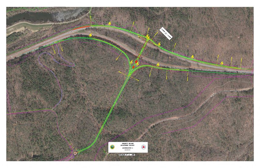
Clayton Road (SR 3501) intersection, the NC 191 corridor is characterized by preserved open space in
proximity to the FBR, Pisgah National Forest, and the BRP. The BRP crosses over NC 191 and is accessible
via the signalized intersection with Frederick Law Olmstead Way at the west end of the proposed project.
The NC Arboretum is also accessible via this intersection.

The Biltmore Park West (BPW) property (see Exhibit 1) will be accessed via NC 191 at a new fourth leg to
the Frederick Law Olmstead Way intersection. The private developer is currently constructing a new
bridge over the FBR and a 2-lane road (Frederick Law Olmstead Way East) to connect to the Pratt &
Whitney (P&W) Manufacturing Center, currently under construction. The private developer is
constructing the bridge to accommodate up to 5 lanes of traffic and has graded the approach roadway to
allow for a future 4-lane cross section. Exhibit 2 shows the lane configuration including the NC 191
intersection and 5 lanes on the new bridge that taper to two lanes east of the FBR. As with many private
development projects where NCDOT anticipates accepting ownership, NCDOT has reviewed and approved
all preliminary plans for the FBR bridge and roadway and has an inspector on-site to confirm the privately-
built transportation infrastructure is constructed to NCDOT standards. The Department anticipates
accepting the bridge and roadway currently under construction (not part of HE-0001) into the State
highway system within a few months following completion.

                                              Biltmore
                                             Park West

                  EXHIBIT 1. BILTMORE PARK WEST (BPW) LOCATION (SOURCE: GOOGLE EARTH)

                                                                                              Page 2 of 21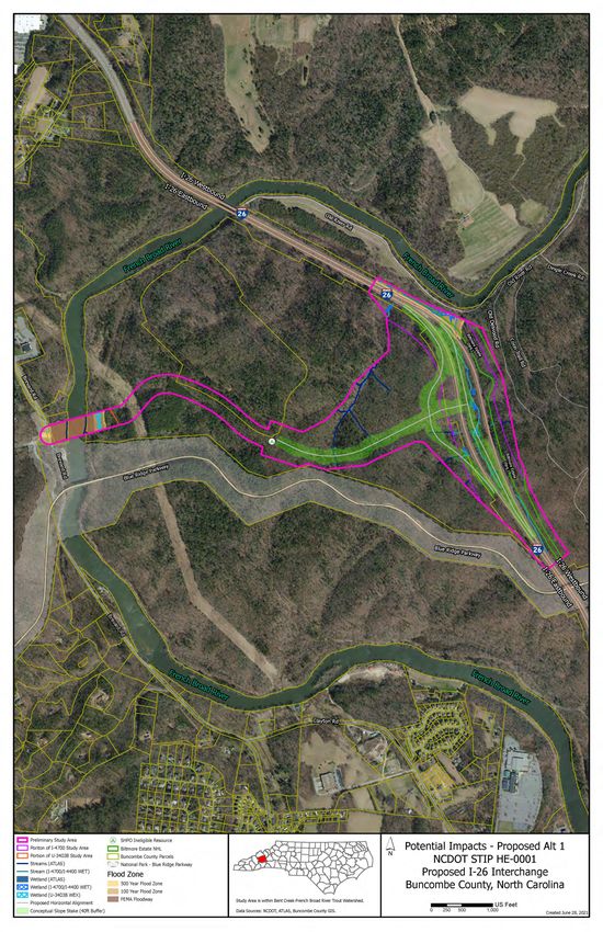
EXHIBIT 2. PRIVATELY BUILT BRIDGE AND ROADWAY LANE CONFIGURATION

Project Status and Schedule
The HE-0001 project is proposed to be federally funded, and NCDOT anticipates documentation as a NEPA
Type III Categorical Exclusion (CE) in Spring 2022.

The proposed project was presented to the NCDOT Board of Transportation in June 2021 to be considered
for approval in July 2021. The STIP addition would initially include funding for preliminary engineering
only. The Division is targeting right of way acquisition and construction for state fiscal years 2022 and
2023, respectively. The current total cost estimate range is between $20 and $35 million.

The French Broad River MPO is in the process of updating their Long-Range Transportation Plan (LRTP)
and Metropolitan Transportation Plan (MTP) and will consider incorporating this project as well as other
modifications necessary to the plans later this summer.

NCDOT hosted an External Scoping Meeting with relevant regulatory agencies on June 16, 2021. The
materials provided for that meeting and a summary of agency scoping comments are included in
Attachment 1.

                                                                                            Page 3 of 21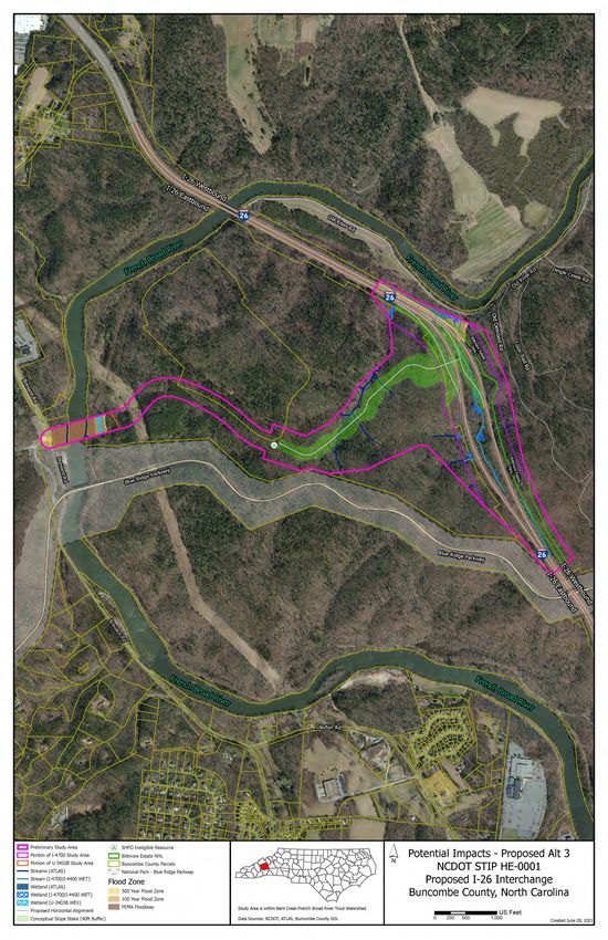
CP 1: Purpose & Need and Study Area Defined
Study Area
The study area generally includes approximately 210 acres along and west of I-26, south of the FBR and
north of the BRP (Figure 2). The study area encompasses enough area to explore interchange locations on
I-26 and allowing NCDOT to accommodate current and planned growth by connecting to Frederick Law
Olmsted Way East. The study area is north of the BRP and south of the FBR to avoid impacts to both
features (inclusive of the bridge infrastructure associated with both), and to account for proposed ramp
length requirements. The study area extends along the roadway under construction to NC 191 to account
for the potential need to provide four-lanes from I-26 to NC 191. This corridor extension is approximately
300 feet wide; the roadway under construction was graded for a 4-lane roadway but is being constructed
as a 2-lane roadway.

The approximately 4.5-mile stretch of I-26 between Exit 33 (Brevard Road) and Exit 37 (Long Shoals Road)
were evaluated for the proposed interchange location. The distance between the BRP bridge piers and
Exit 37 (approximately 1 mile) would not allow for the required distance of 1-mile between interchanges
on the interstate system. Further, the FBR is approximately 500 feet east of I-26 and roughly parallels this
interstate section. There is approximately 1-¾-mile between Exit 33 and the I-26 bridge over the FBR;
however, private development (e.g., manufacturing/warehouses, residences) is present along the west
side of the interstate. The locations along I-26 north of the FBR and south of the BRP would not facilitate
the development of alternatives to meet the project’s purpose to accommodate current and planned
growth and are therefore not included in the project’s study area.

Study Area Refinement Following External Scoping
A slightly larger study area was reviewed at the External Scoping Meeting (June 16, 2021) encompassing
approximately 290 acres (refer to Attachment 1). That study area was refined to the smaller, 210-acre
study area that is included in this CP 1 packet.

The reduction was primarily along the northern extent of the larger study area, based upon engineering
judgement and topographic constraints. Conceptual roadway design review showed the proximity to the
French Broad River through this northern section creates unreasonable engineering design constraints for
interchange ramp design, making the encroachment within the French Broad River floodplain an
impractical design solution. Therefore, the HE-0001 Study Area was reduced to follow the existing I-26
control of access boundary and the I-4700 Study Area. Also, due to topography within the development
parcel west of I-26, proximity to the ongoing and planned developments, and roadway geometry
considerations associated with the roundabout approach, conceptual roadway design determined the
most reasonable roadway tie in this area would remain on the east side of the potential jurisdictional
stream (blue-line) bisecting the property. Therefore, the HE-0001 Study Area was reduced to reflect these
constraints.

The reduction of the HE-0001 Study Area by approximately 80 acres does not appear to unnecessarily
constrain the development of reasonable and feasible interchange locations on I-26 or to provide for a
roadway tie to the 2-lane roadway currently under construction by the private developer. This reduction
in area will also result in more focused efforts in the collection of field data by NCDOT.

                                                                                               Page 4 of 21
Need for Project
The proposed project is needed to address the lack of network connectivity between NC 191 and I-26 in
southern Buncombe County to accommodate current and planned growth.

Project Purpose
The purpose of the project is to provide access to I-26 and improve east-west connectivity within the
project vicinity to accommodate current and planned growth.

Secondary Benefit
Other desirable outcomes of the proposed project are:

    -   improved traffic safety due to greater separation of local traffic from interstate traffic;
    -   improved emergency response times to the P&W Manufacturing Center, BPW property, and NC
        191;
    -   support for local and regional economic development initiatives in the project vicinity;
    -   improved access to anticipated regional employment opportunities at P&W Manufacturing
        Center and BPW; and
    -   improved access to tourist destinations.

Transportation Network Performance
Traffic Volumes
NCDOT prepared a Traffic Forecast for HE-0001 (June 29, 2021). Current (2021) and future year (2045)
traffic volumes are summarized in Table 1.

The adjacent interchanges (Exits 33 and 37) and roadways (i.e., NC 191 and NC 146) that would be utilized
in a No Build scenario currently experience peak-hour congestion. On-going and planned development at
BPW are expected to contribute to additional future congestion of adjacent interchanges and roadways
in the No-Build scenario.

         Table 1. AADT Summary*
                                                                          2021 AADT       2045 AADT
             Roadway (Segment)                      Lanes
                                                                          (No Build)      (No Build)
         I-26 (north of NC 191)        4-lane (8-lane 2024)                  89,000        131,800
         I-26 (south of NC             4-lane (8-lane 2024)                  88,100        129,000
         191/north of NC 146)
         I-26 (south of NC 146)        4-lane (8-lane 2024)                  85,700        125,400
         NC 191 (west of I-26)         4-lane divided                        30,700        46,600
         NC 191 (south of NC 112)      4-lane divided or w/TWLTL             23,300        35,800
         NC 191 (north of BRP)         4-lane divided or w/TWLTL             20,600        32,000
         NC 191 (south of BRP)         2-lane                                18,900        28,000
         NC 146 (west of I-26)         4-lane divided                        24,800        37,600
         *
          The Project Forecast was finalized 6/29/21 and is currently being evaluated. NCDOT can
         address questions regarding the forecast at or leading up to meeting.

                                                                                                   Page 5 of 21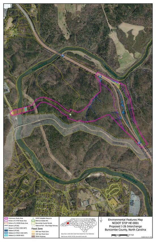
Access Needs and Connectivity
Currently motorists accessing this area use Exit 33 (NC 191/Brevard Road) and Exit 37 (NC 146/Long Shoals
Road) which contributes to congestion at these interchanges and connecting roadways. As shown in Table
2, it is estimated that there is currently a 9- to 14-minute travel time between the adjacent interchanges
and the project area. These travel times would be expected to increase in the future No Build scenario
because of increased traffic volumes and traffic congestion.

The project is anticipated to improve traffic operations throughout the area roadways, intersections, and
interchanges by introducing a new access to the interstate, thus improving local/regional access and
connectivity to meet current and future travel demand projected because of Buncombe County
population and employment growth.

A preliminary network connectivity review using Google Maps concluded that an additional I-26 access
point should have a positive effect by reducing regional vehicle-miles-traveled (VMT) and vehicle-hours-
traveled (VHT) (Table 2). Travel time estimates based on current conditions utilizing Google Maps
indicate a 7- to 12-minute travel time savings in the PM Peak Hour and a reduction in vehicle miles
traveled by up 2.9 miles.

Table 2. Summary of Potential Travel Time Savings and Vehicle Miles Traveled
                                                                   Travel
                                                  Miles2
Scenario     Origin     Destination (I-26)                         Time2        Route Characteristics
                                                  (miles)
                                                                   (mins)
                        Northbound                                             -    8 traffic signals
                                                     3.4             14
                        (NC 191/I-26)                                          -    5-lane roadway
No Build
                        Southbound                                             -    3 traffic signals
                                                     3.6              9
             BPW        (NC 146/I-26)                                          -    2-lane to 4-lane roadways
             RAB1
Build                   Proposed Exit 35             0.7              1        -    2- to 4-lane roadway

1
  RAB = roundabout included in site plan, to be constructed by developer with or without HE-0001.
2
  Projected in Google Maps, PM Peak Hour (5:30 PM) conditions. For purposes of this high-level analysis, the
following assumptions were made about the proposed new alignment roadway: 35 mph travel speed; distance
between BPW RAB and NC 191 estimated to be 0.6 mi (resulting in 1:02 mins travel time) and distance between
RAB and I-26 estimated at 0.7 mile (resulting in 1:12 mins travel time).

Growth Management
Buncombe County and other regional partners have embraced the P&W development, a 1 million square
foot advanced manufacturing center on 100 acres in Biltmore Park West announced in October 2020 and
have pledged their support. On November 17, 2020, Buncombe County Board of Commissioners (BOC)
adopted a “Resolution Authorizing Buncombe County to Pay Economic Development Incentives and to
Sign Economic Development Agreement” (Resolution #20-11-16); the Incentive Agreement with P&W was
executed the following month, on December 9, 2020. NCDOT is not a party to the County Incentive
Agreement. The agreement defines P&W commitments to investment and jobs in exchange for County
incentives in the amount of $27 million. P&W committed to create 750 full-time project-related jobs on
or before December 31, 2029. The Buncombe County BOC approved P&W’s rezoning request on March

                                                                                                  Page 6 of 21
16, 2021 to move an 11.57-acre portion of the property from R-3 Residential to EMP-Employment (Case
No. ZPH2020-00042 Ranger CUP).

P&W is the first development at BPW and additional future investment is planned. The entire property
consists of approximately 575 acres of which roughly 175 acres are considered developable. The private
developer expects that the property will be mixed-use in character with a tendency towards density. Table
3 lists the current development estimates provided by the private developer in May 2021.

                        Table 3. Biltmore Park West Development Estimate
                        Land Use                       Quantity (Unit)
                        Residential                    1,218 dwelling units
                        Retail/Office                  178,000 square feet
                        Hotel                          120 rooms
                        Public Service/Institutional   60,000 square feet
                        Industrial                     460,000 square feet
The NC 191 corridor currently supports mixed uses including single-family neighborhoods, commercial
and employment districts, and recreation uses. These land uses would likewise benefit from improved
access to the interstate.

Safety
The proposed interchange has the potential to provide shorter distances for truck traffic which originates
and terminates at the P&W Manufacturing Center and adjacent land uses on NC 191 and generally
introduces a scenario that would allow for greater separation of local traffic from interstate traffic. The
presence of freight-trucks in the traffic mix will increase congestion and travel times, particularly in
mountainous terrain, due to a variety of factors. Heightened congestion resulting in stop-start traffic flow
pose greater safety hazards to motorists and it is expected the separation of truck traffic would benefit
safety to some degree.

Tables 4 and 5 (page 8) summarize available planning-level crash data compiled by NCDOT for the five-
year period between 2015-2019. Available crash data indicate higher crash frequencies along I-26 and at
the intersections and segments in proximity to the NC 191 and NC 146 interchanges. While I-26 widening
and interchange improvements at NC 191 are expected to have safety benefits at these locations, they
would not be expected to improve safety conditions further from the interchanges (e.g., NC 191/SR 3501).
A new interchange has the potential to disperse traffic and provide a safer and more direct access point
to I-26.

                                                                                               Page 7 of 21
Table 4. NCDOT 2015–2019 Total Crash Frequency by Intersection
Intersection                                         Total Crash Frequency
I-26 at NC 191                                       50 and above
SR 3428 (Rocky Ridge Rd) at NC 191*                  20–29
Oak Terrace Dr at NC 191                             10–19
NC 112 at NC 191                                     40–49
SR 3477 (Morris Rd) at NC 191                        5–9
SR 3479 (Pole Creasman Rd) at NC 191                 5–9
SR 3480 (Dry Ferry Rd [North]) at NC 191             10–19
Frederick Law Olmstead Way/BRP Access at NC 191** 5–9
SR 3501 (Clayton Rd) at NC 191                       40–49
SR 3501 (Clayton Rd) at NC 146                       10–19
SR 3498 (Ledbetter Rd) at NC 146                     20–29
I-26 at NC 146                                       50 and above
Schenck Pkwy at NC 146                               50 and above
*Intersection will be revised by I-4700
**Intersection will be revised by Project Ranger/Biltmore Farms

Table 5. NCDOT 2015 – 2019 Section Safety Scores
66–100+
I-26 between NC 191 and NC 146*             NC 191 at Frederick Law Olmstead Way/BRP
                                            Access
NC 191 at [SR 3428 (Rocky Ridge Rd)]/I-26   NC 191 at SR 3501 (Clayton Rd)
EB on- and off-ramp
NC 191 at Oak Terrace Dr                    SR 3501 (Clayton Rd) at NC 191
NC 191 at NC 112                            NC 146 at SR 3501 (Clayton Rd)
NC 191 at SR 3477 (Morris Rd)               NC 146 at SR 3498 (Ledbetter Rd)
NC 191 at SR 3479 (Pole Creasman Rd)        NC 146 at Schenck Pkwy
+
  This dataset contained crash data grouped by half mile roadway segments on State maintained roadways
in North Carolina. Segments are assigned a score of 0-33, 33-66, and 66-100. Higher scores are considered
to have poorer highway safety performance and are the only segments reported here. This data should be
viewed as planning level data only.
*This section will be widened by I-4700

                                                                                                Page 8 of 21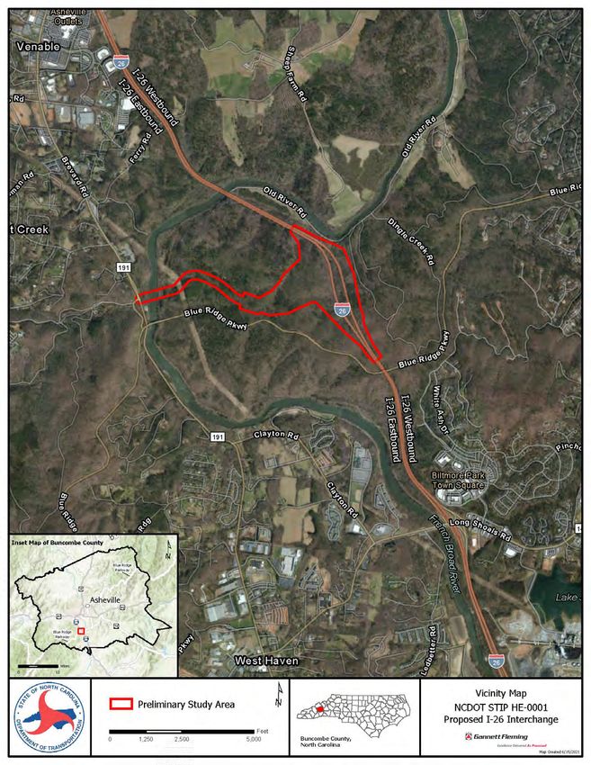
CP 2: Detailed Study Alternatives Carried Forward
The following alternatives do not meet the project’s purpose and need and are recommended for
elimination from further consideration:

No-Build Alternative - The No-Build Alternative would not provide any transportation improvements in
the study area. Access to BPW would be limited to NC 191. The No-Build Alternative would not incur right
of way or construction costs. There would be no impacts to streams, wetlands, or other natural and
cultural resources. The No-Build Alternative would not improve access and connectivity, reduce travel
times and distances, or improve safety within the project limits. While the No-Build Alternative is
recommended for elimination, it provides a baseline for comparing the adverse impacts and benefits of
the Build Alternatives and will be carried forward for that reason.

Mass Transit Alternative - The Mass Transit Alternative considered forms of transportation other than the
single-occupancy passenger vehicle. Fixed route, regular service mass transit operated by Asheville Rides
Transit (ART) is not available in the project area. ART Route W2 serves the NC 191 corridor between
Downtown Asheville and NC 112 (Sardis Road)/Ridgefield Court. A lack of demand, low population density,
diffused employment centers, and diversity of trip origins and destinations complicates mass transit
effectiveness serving the project area and would not alone meet the project need. For these reasons,
mass transit will not capture the requisite number of person trips to make this alternative a reasonable
and feasible alternative.

Transportation Systems Management Alternative - Transportation System Management (TSM)
Alternative improvements typically involve low‐cost, minor transportation improvements to increase the
capacity of an existing facility, and do not include reconstructing or adding additional through lanes. TSM
improvements on NC 191 and/or I-26 in the study area, such as ramp termini modifications,
acceleration/deceleration and/or turn lane lengths, and signing upgrades, would not noticeably reduce
congestion nor would they improve access or connectivity. Therefore, the TSM Alternative would not
meet the project’s need and is not recommended as a detailed study alternative.

Build Alternatives
To meet the purpose of the project and address the transportation needs, NCDOT proposes a new
interchange and roadway extension as the baseline for build alternatives. NCDOT evaluated 15 possible
designs at a conceptual level. These concept designs have a similar footprint and were narrowed based
on the following engineering considerations and constraints:

Interchange Configuration
Modified diamond and diverging diamond interchange configurations were considered to minimize the
interchange footprint and meet design requirements. The traffic operations of such configurations will
continue to be refined to meet design standards, safety needs, and resource impact minimization.

Westbound Ramp Location
A left-exit scenario (in addition to a traditional right-exit scenario) was considered as an option to avoid
impacts to the Biltmore Estate National Historic Landmark (NHL).

                                                                                               Page 9 of 21
Interchange Location
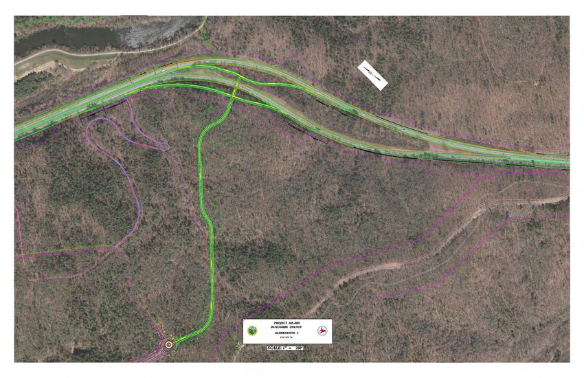
The location of the proposed interchange within the I-26 bifurcated section is constrained by the BRP
bridge piers roughly ¼-mile to the south and the FBR bridge approximately ¾-mile to the north. Ramp
length requirements and existing infrastructure associated with I-4700, including a soil-nail retaining wall
south of the FBR along the eastbound I-26 travel lanes and concrete barrier wall between eastbound and
westbound I-26 travel lanes, further constrain the interchange location to the north. The presence of the
FEMA floodway and jurisdictional features southeast of the I-26 FBR bridge were also considered.
A central location within the bifurcated section is closer to the BRP and could cause greater impacts to
the bifurcated section. This location avoids the FEMA floodway and jurisdictional features along the south
(or west) bank of the FBR.
A northern location within the bifurcated section is closer to the FBR and further from the BRP. A left exit
ramp would still be feasible at this location. This location could reduce the overall impact to the bifurcated
section.
Roadway Tie
NCDOT explored three roadway tie alignment concepts between the interchange ramp terminals and
Frederick Law Olmstead Way East under construction by the private developer: a direct approach, a
contour approach, and an “upgrade” approach. The contour approach laid out an alignment conforming
to the natural topography in an effort to reduce cut and fill activity; however, it was determined a strict
contour approach will not meet horizontal alignment design requirements.
The upgrade approach evaluated at a high-level the potential to reuse some of the gravel roads that
traverse the property. These gravel roads were reportedly built by NCDOT in the 1950s to reestablish
connections to the Biltmore property that would be severed by construction of I-26. These gravel roads
are variable in width (up to 30 feet wide) and do not meet current geometric design standards. It was
determined that a strict upgrade approach will not meet horizontal alignment design requirements.
Further, these old roads are generally close to potentially jurisdictional streams.
Based on the engineering constraints and requirements of the considerations above, NCDOT proposes the
following build alternatives be carried forward for detailed study (Table 6, page 11); a No Build Alternative
would also be retained to provide the baseline against which to measure potential benefits and impacts.
These three proposed build alternatives represent two interchange locations and three interchange
configurations. The left-exit option is retained at both locations; however, based on a conceptual-level
screening a right exit (i.e., traditional interchange configuration) at the north end of the I-26 bifurcated
section is not recommended due to impacts to the FEMA regulated floodway, associated floodplains, and
known wetland resources.
The NCDOT will consider traffic operations in the final recommendation for the interchange ramp terminal
treatment(s). A 2- to 4-lane connecting roadway section is being considered; NCDOT anticipates making
this decision prior to the meeting. Avoidance and minimization measures will continue to be evaluated
throughout design development and in consultation with the Merger Team.
Table 7 (page 11) compares the potential impacts to known environmental features for each interchange
alternative, including the four-lane roadway tie. Potential impacts are calculated based on conceptual
design slope stake limits plus 40 feet to cover potential utility and erosion control footprints.
Page 10 of 21Table 6. Build Alternative Description
Build Alternative Description Figures
• left exit/entrance ramp
Alternative 1 • Diamond configuration 3&4
• center of the I-26 bifurcated section
• right-exit/entrance ramp
Alternative 2 • Diverging diamond (DDI) configuration 5&6
• center of the I-26 bifurcated section
• left exit/entrance ramp
Alternative 3 • Diamond configuration 7&8
• North end of the I-26 bifurcated section
Table 7. Build Alternative Comparison (based on conceptual design slope staked plus 40 feet)
Alternative 1 Alternative 2 Alternative 3
Stream length (ft) – I-4700 1,900 2,100 900
Stream length (ft) – ATLAS 700 800 1,100
Stream Total (ft) 2,600 2,900 2,000
Surface Water
Wetland (acre) – I-4700 0.2 0.2 0.1
Wetland (acre) – ATLAS/NWI 0 0 0.1
Wetland Total (acre) 0.2 0.2 0.2
100-yr Floodplain (acre) < 0.1 0.2 0
FEMA 500-yr Floodplain (acre) < 0.1 0.4 0
Floodway (acre) 0 0 0
Cultural Resource Biltmore Estate NHL (acre) 0 6.8 0
Page 11 of 21Sources
Buncombe County, Incentive Agreement, Pratt and Whitney, a Division of Raytheon Technologies
Corporation and Buncombe County, North Carolina, Dec. 9, 2020.
---, Resolution Authorizing Buncombe County to Pay Economic Development Incentives and to Sign
Economic Development Agreement (Resolution #20-11-16), Nov. 17, 2020.
City of Asheville, “Transit maps and schedules”. Accessed online June 9, 2021 at
www.ashevillenc.gov/service/transit-maps-schedules/
NCDOT Annual Average Daily Traffic (AADT) Mapping Application,
ncdot.maps.arcgis.com/apps/webappviewer/index.html?id=5f6fe58c1d90482ab9107ccc03026280
---, Planning Level Safety Scoring Data Mapping Application,
ncdot.maps.arcgis.com/home/webmap/viewer.html?webmap=7415a4df4df1468585225bc74a77369b
---, Total Crash Frequency by Intersection Mapping Application,
ncdot.maps.arcgis.com/home/webmap/viewer.html?webmap=dc944f1c834f49a18479c17df1f783b9
Page 12 of 21FIGURE 1. VICINITY MAP
Page 13 of 21FIGURE 2. STUDY AREA AND ENVIRONMENTAL FEATURES MAP
Page 14 of 21FIGURE 3. PROPOSED BUILD ALTERNATIVE 1
Page 15 of 21FIGURE 4. POTENTIAL IMPACTS, PROPOSED BUILD ALTERNATIVE 1
Page 16 of 21FIGURE 5. PROPOSED BUILD ALTERNATIVE 2
Page 17 of 21FIGURE 6. POTENTIAL IMPACTS, PROPOSED BUILD ALTERNATIVE 2
Page 18 of 21FIGURE 7. PROPOSED BUILD ALTERNATIVE 3
Page 19 of 21FIGURE 8. POTENTIAL IMPACTS, PROPOSED BUILD ALTERNATIVE 3
Page 20 of 21Section 404/NEPA Merger Project Team Meeting Agreement
Concurrence Point 1
Study Area Defined and Project Need and Purpose
Project Name/Description: I-26, New Interchange (Future Exit 35), Buncombe County
STIP Project: HE-0001
The proposed project is needed to address the lack of network connectivity between NC 191 and I-26 in
southern Buncombe County to accommodate current and planned growth.
The purpose of the project is to provide access to I-26 and improve east-west connectivity within the
project vicinity to accommodate current and planned growth.
The Project Team has concurred on this date, July 15, 2021, on the above project need and purpose and
the study area defined (Figure 2) for STIP Project HE-0001.
USACE __________________________
FHWA ___________________________
NCDOT _________________________
NCDWR __________________________
USEPA __________________________
SHPO ____________________________
USFWS __________________________
FBRMPO _________________________
NCWRC __________________________
Page 21 of 21Section 404/NEPA Merger Project Team Meeting Agreement
Concurrence Point 2
Detailed Study Alternatives Carried Forward
Project Name/Description: I-26, New Interchange (Future Exit 35), Buncombe County
STIP Project: HE-0001
The Project Team has concurred on this date, July 15, 2021, that all checked alternatives will be carried
forward to be studied in detail for STIP Project HE-0001.
If the traffic forecast shows that only two lanes are required for the roadway tie, Concurrence Point 2 will
be revisited.
DSA
Carried
DSA Description Figures
Forward
(Y/N)
The No-Build Alternative does not meet the project’s need and
No Build purpose but will be retained to provide a basis for comparing NA
adverse impacts and benefits of the detailed study alternatives.
Modified diamond interchange configuration located in the center
Build
of the I-26 bifurcated section and includes a left exit/entrance 3&4
Alternative 1
ramp.
Diverging diamond interchange (DDI) configuration located in the
Build
center of the I-26 bifurcated section and includes a right 5&6
Alternative 2
exit/entrance ramp.
Build Tight diamond interchange configuration located at north end of
7&8
Alternative 3 the I-26 bifurcated section and includes a left exit/entrance ramp.
USACE __________________________
FHWA ___________________________
NCDOT _________________________
NCDWR __________________________
USEPA __________________________
SHPO ____________________________
USFWS __________________________
FBRMPO _________________________
NCWRC __________________________
Page 22 of 21CONCURRENCE POINTS 1 AND 2
I-26 Interchange (Future Exit 35)
Buncombe County
STIP Project HE-0001
WBS No. TBD
ATTACHMENT 1
External Scoping Meeting Summary and External Scoping
Meeting PacketProject: HE-0001, New Interchange with I-26
Project No.: 064926.050
Subject: External Scoping Meeting Summary
Date: June 16, 2021 8:30 am
Location: Remote (GoTo Meeting)
Attendees:
Name Representing Email
McCray Coates NCDOT-Division 13 hmcoates@ncdot.gov
Mark Gibbs NCDOT-Division 13 mgibbs@ncdot.gov
Roger Bryan NCDOT-Division 13 rdbryan@ncdot.gov
Derrick Weaver NCDOT-EPU dweaver@ncdot.gov
John Jamison NCDOT-EPU johnjamison@ncdot.gov
Mike Sanderson NCDOT-EPU jmsanderson@ncdot.gov
Marissa Cox NCDOT-Biological Surveys mrcox@ncdot.gov
Cheryl Knepp NCDOT-Biological Surveys clknepp@ncdot.gov
Tyler Stanton NCDOT-Biological Surveys tstanton@ncdot.gov
Donnie Brew FHWA Donnie.Brew@dot.gov
Joe Geigle FHWA Joseph.Geigle@dot.gov
Lori Beckwith USACE Loretta.A.Beckwith@usace.army.mil
Kevin Mitchell NCDWR Kevin.Mitchell@ncdenr.gov
Amanetta Somerville USEPA Somerville.Amanetta@epa.gov
Holland Youngman USFWS Holland.Youngman@fws.gov
Lauren Wilson USFWS lauren_wilson@fws.gov
Marla Chambers NCWRC Marla.Chambers@ncwildlife.org
Tristan Winkler FBRMPO tristan@landofsky.org
John Ridout FBRMPO john@landofsky.org
Heather Wallace NV5 Heather.Wallace@nv5.com
Rick Tipton Gannett Fleming rtipton@gfnet.com
Adam Archual Gannett Fleming aarchual@gfnet.com
John Thomas Gannett Fleming jthomas@gfnet.com
This project proposes to construct a new interchange (future Exit 35) with I-26 and connecting
roadway to access the Pratt & Whitney (P&W) Manufacturing Center currently under
construction. The project is located approximately 6 miles south of Asheville in Buncombe
Gannett Fleming, Inc.
Suite 900 • One Glenwood Avenue • Raleigh, NC 27603
t: 919.420.7660 • f: 919.999.3632
www.gannettfleming.comCounty. NCDOT-Division 13 is managing the project and anticipates federal funding. The
Division is targeting an October 2022 construction let date.
The intent of this meeting was to provide information about the proposed project to the state
and federal resource agency partners and collect feedback and direction in the development of
the project. The PowerPoint Presentation is attached to this summary and the meeting packet
may be accessed via the NCDOT file transfer site. The following topics were discussed at the
meeting:
- Jurisdictional Resources
o NCDOT will spot check approved delineations completed for I-4700 and
U-3403B while delineating the remainder of the study area. Full delineation
within the previously surveyed areas is not required but delineations should be
field checked.
The Project Ranger delineation expires in October of 2021 and will not be
relied on by this project.
o NCDOT should plan on a field verification with the USACE and NCDWR; that
should be expected later this summer.
o The JD submittal should explain the history and status of the intersecting JDs,
their status, and results of spot checks; these features should also be provided in
the mapping.
- Agency Input/Comments
o USACE
Due to conflicting resources and the unique situation of this project
overlapping the I-4700 project currently under construction, the USACE
agrees with the decision to proceed in the Merger process.
Requested that the project purpose statement does not offer a solution to
the project need statement (available in the External Scoping Meeting
packet).
o NCDWR
Agreed with decision to proceed in the Merger process.
In review of the 2016 Project Ranger JD, noted the presence of several
pocket, headwater wetlands adjacent to first order tributaries to the
French Broad River.
The streams and habitat are in good condition based on past
observations.
Avoidance and minimization will be important.
Page 2 of 5 A good stormwater management plan is necessary associated with
concerns for downstream aquatic habitat for endangered Appalachian
elktoe (Alasmidonta raveneliana) in the French Broad River.
o USFWS
Agreed with plan to observe/incorporate/consider the conservation
measures and commitments NCDOT made for the I-4700 project and
Project Ranger (FWS log # 19-328).
Recommend consider tree clearing in the winter in regard for concerns
with the threatened Northern long-eared bat (Myotis septentrionalis), soon
after the proposed October 2022 construction let date.
o USEPA
Requested additional detail on the annual average daily traffic (AADT) in
future discussions to support this project would not adversely affect
I-4700.
Will the French Broad River bridge currently under construction by the
private developer accommodate future traffic needs?
• The private developer is constructing the bridge with five lanes
and the roadway is being constructed with two-lanes but has been
cleared and graded for four-lanes.
o NCWRC
Agrees with Merger decision.
Will review the U-3403B and I-4700 WRC letters and resend to the
appropriate members of this group.
Will be looking for proper passage of fish and wildlife.
Will also need to plan to treat stormwater to prevent degradation of the
French Broad River.
o FBRMPO
Working on amending the MTP with target of this month but reserving
the option to hold amendments until August if additional conversation is
warranted.
Some concerns have been voiced by the TCC about this project and its
impacts to funding availability for other planned transportation projects
in the MTP.
It was noted that land-use modeling and socioeconomic data for this TAZ
is a high-growth area. This was coded before the proposed project was
conceived.
o SHPO (not present)
Page 3 of 5 In the absence of SHPO, the team was informed that coordination has
begun with Mary Pope Furr and Matt Wilkerson and these studies are
underway.
- General Conversation
o Need and Purpose
USACE suggested holding a CP 1-2 pre-meeting with the MOU
signatories and noted that the “direct access” in the preliminary purpose
statement would have to be taken under consideration internally.
o Merger
The new Merger procedure has not been finalized yet, but some of the
ideas in that procedure update may be applied to this project with the
team’s approval.
USACE stated that information about the impacts of this project on the
I-26 LOS will be necessary prior to a CP 3/LEDPA decision.
• FHWA clarified that they cannot approve the IAR (Interchange
Access Report), and ultimately the project, if it results in
significant adverse effect on the interstate. However, it is possible
that an LOS less than service level D could be considered not
adverse.
• It was noted that the I-4700 traffic analysis uses a 2040 design
year, whereas this project is a 2045 design year.
o Study Area
A reduced study area was presented to the team.
• USEPA asked whether the reduction would limit design options
under consideration.
• NCDOT noted that the reduction was based on evaluation of
design factors and environmental factors. The northern section of
the larger study area present conflicts with the French Broad River
FEMA floodplains and jurisdictional wetlands identified in
environmental studies for I-4700. Also, topography west of a blue-
line stream bisecting the parcel west of I-26 presented design
concerns that would be lessened by alternatives to the east of the
stream.
o USACE replied that alternatives and/or associated study
area limits should not be discarded without agencies
review and comment.
Page 4 of 5• NCDOT noted that reducing the study area made sense because it
would reduce the time and effort associated with field data
collection (e.g., archaeology) in areas that we would not expect to
build in.
• USEPA requested that this explanation be documented.
This concludes the summary of the discussions held during the HE-0001 External Scoping
Meeting to the best of my recollection.
Adam Archual
June 17, 2021
Page 5 of 5External Scoping Meeting STIP Project HE-0001 June 16, 2021
HE-0001 External Scoping Meeting

                             AGENDA
•   Introductions
•   Meeting purpose and goals
•   Project description and history
•   Existing conditions
•   Project scoping/agency input
•   Preliminary need and purpose
•   Interchange concepts
•   Next steps/schedule

                                                                     2
HE-0001 External Scoping Meeting
INTRODUCTIONS
• NCDOT • FBRMPO
• Federal Highway Administration • Consultants
• US Army Corps of Engineers
• NC DEQ – Division of Water
Resources
• US Fish and Wildlife Service
• Environmental Protection Agency
• NC Wildlife Resources Commission
• NC State Historic Preservation Office
3HE-0001 External Scoping Meeting
MEETING PURPOSE & GOALS
• Transfer information about project to agencies and external
partners
• Understand project background
• Identify constraints
• Strategize next steps
– FHWA and NCDOT will proceed in Merger
4HE-0001 External Scoping Meeting
PROJECT LOCATION
• Approx. 6 mi south of
Asheville
• North of Blue Ridge
Parkway, south of
French Broad River
5HE-0001 External Scoping Meeting
PROJECT DESCRIPTION
2-lane roadway
(w/roundabout)
currently under
construction.
Note: graded for
ultimate 4-lane
5-lane bridge
currently under
construction
6HE-0001 External Scoping Meeting
PROJECT DESCRIPTION
• Construct new interchange on I-26 (future Exit 35)
• Construct approx. ½-mile new location roadway extension
7HE-0001 External Scoping Meeting
PROJECT CONTEXT
• 2016 – Biltmore Farms, Inc. secures preliminary JD (SAW-2016-01112)
• 2019 – USFWS issues final BO for the NCDOT Project I-4400/I-4700
• 2019 – NCDOT Project I-4400/I-4700 FEIS/ROD signed
• 2020 – USACE receives SHPO determination (ER 19-4972) (“Project
Ranger”)
• 2020 – USACE issues NWP 14 and 25 French Broad River bridge to access
Project Ranger (SAW-2019-01867)
• 2020 – USFWS issues a BO (FWS Log # 19-328) for Project Ranger
• 2020 – Pratt & Whitney announces 1 million sf advanced manufacturing
center on 100-acre site
• 2020 – Buncombe County resolution
8HE-0001 External Scoping Meeting
ACTIVITIES TO DATE
Submit project for funding January 2021
Concept alternatives development March 2021
Begin Traffic Forecast April 2021
Crash Analysis Request May 2021
ETRACS (Cultural Resources) May 2021
Internal Scoping Meeting May 2021
Merger decision May 2021
Begin T&E surveys June 2021
9HE-0001 External Scoping Meeting
ON-GOING AND FUTURE ACTIVITIES
• Finalize Scoping Report (June/July 2021)
• Concurrence Points 1 & 2 (July 2021)
• Project-specific Travel Demand Model (July 2021)
• HE-0001 added to STIP (July 2021)
• Technical studies (Summer-Fall 2021)
10HE-0001 External Scoping Meeting
PROJECT FUNDING SCHEDULE
• Categorical Exclusion: FY 2022
• Right of Way: FY 2022
• Construction: FY 2023 (let October 2022)
11HE-0001 External Scoping Meeting
NEARBY STIP PROJECTS
STIP Project No. Schedule (FY)
I-5504 I-4700 Under Construction
U-6047
I-5504 Under Construction
HE-0001 U-2801A U-2801A RW 2024 | CST 2027
U-3403B RW 2029 | CST Post Year
U-5834 RW In progress | CST 2024
U-6047 RW 2025 | CST 2028
U-5834
HO-0002 Unknown
HO-0002A Unknown
U-3403B I-4700
12HE-0001 External Scoping Meeting
EXISTING CONDITIONS
Interchange Tie-in
Existing Proposed Existing Proposed
Right of Way Varies, 270-830 ft on I-26 TBD TBD
Type of Access Control N/A Full control No control
N/A
Roadway Typical Section N/A 1-2 lane 2-4 lane
Speed 70 mph on I-26 40 mph
Length of Project Approx. ½- to 1-mile
Buncombe Bridge Nos. 100214 (I-26 EBL) and 100211 (I-26 WBL) over French Broad River;
Bridge/Culvert Inventory Buncombe Bridge No. 100205 (Blue Ridge Parkway over I-26); Project Ranger Bridge over French
Broad River (under construction)
Functional Classification Interstate
Strategic Transportation Corridor C (I-26/US 23)
Corridor Information
13HE-0001 External Scoping Meeting
ENVIRONMENTAL FEATURES
• Human Environment
– Section 106/Section 4(f) resources
• Natural Environment
– Jurisdictional resources
– FEMA resources
– T&E species
14HE-0001 External Scoping Meeting
HUMAN ENVIRONMENT
• Biltmore Park West under development
• Commercial/office and residential subdivisions at adjacent
interchanges
Asheville Outlets Biltmore Park
15HE-0001 External Scoping Meeting
NATURAL ENVIRONMENT
• 11 steams and French Broad
River
– 7 streams (within I-4700 study area)
– 4 other streams (ATLAS)
• Approx. 11 acres wetlands
– Approx. 10 acres (within I-4700 study
area)
– Approx. 1 acre (ATLAS; NWI)
• FEMA floodway, floodplain
16HE-0001 External Scoping Meeting
NATURAL ENVIRONMENT
• T&E species Species Status
– 8 threatened Carolina northern flying squirrel E
– 1 threatened/similar in appearance, and Gray bat E
– 3 endangered species Northern long-eared bat T
Bog turtle T/A
Appalachian elktoe E
Blue Ridge goldenrod T
Mountain sweet pitcher plant E
Spreading avens E
Virginia spiraea T
Rock gnome lichen E
17HE-0001 External Scoping Meeting
INTERNAL SCOPING NOTES
• NCDOT-EAU – Biltmore Estate (NHL) – Section 4(f)
and Section 106
– U-3403B
– Plan for Individual Permit • FBRMPO
• Merger applicability – Working to amend MTP
– Observe environmental commitments – Buncombe County Bent Creek
attached to I-4700 Greenway Corridor
• Clearing restrictions
• Erosion control measures
• Consider interchange lighting
– BRP/NPS involvement will affect
species surveys
18HE-0001 External Scoping Meeting
INDIVIDUAL AGENCY INPUT
• Federal Highway Administration
• US Army Corps of Engineers
• NC DEQ–Division of Water Resources
• US Fish and Wildlife Service
• Environmental Protection Agency
• NC Wildlife Resources Commission
• NC State Historic Preservation Office
• FBRMPO
19HE-0001 External Scoping Meeting
PRELIMINARY PROJECT NEED & PURPOSE
• Need Statement: The proposed project is needed to address the
lack of network connectivity between NC 191 and Interstate 26 in
southern Buncombe County to accommodate current and planned
growth.
• Purpose Statement: The purpose of the project is to provide
direct access to I-26 and improve east-west connectivity within the
project study area.
20HE-0001 External Scoping Meeting
PROPOSED INTERCHANGE
ALTERNATIVES
• Modified diamond
Proposed Alternative 1 • Center of the I-26 bifurcated section
• Left-exit/entrance ramp
• Diverging diamond (DDI)
Proposed Alternative 2 • Center of the I-26 bifurcated section
• Right-exit/entrance ramp
• Tight diamond
Proposed Alternative 3 • North end of the I-26 bifurcated section
• Left-exit/entrance ramp
Note: Ramp terminal configurations will be determined based on traffic
operations analysis later, as appropriate. Potential ramp terminal treatments
are constrained in some locations.
21HE-0001 External Scoping Meeting
PROPOSED INTERCHANGE
ALTERNATIVE 1
22HE-0001 External Scoping Meeting
PROPOSED INTERCHANGE
ALTERNATIVE 2
23HE-0001 External Scoping Meeting
PROPOSED INTERCHANGE
ALTERNATIVE 3
24HE-0001 External Scoping Meeting
REVISED STUDY AREA
HE-0001
Preliminary
HE-0001 Study Area
Preliminary
Study Area - Rev
U-3403B
Study Area
I-4700
Study Area
25HE-0001 External Scoping Meeting
TENTATIVE PROJECT SCHEDULE (Subject to change)
Activity Date
Traffic Forecast
Concurrence Point 1 & 2
Indirect and Cumulative Effects (ICE) Report Summer 2021
NRTR/Jurisdictional Determination
Stakeholder/Small Group Meetings
Interchange Access Report (IAR)
Local Officials’ Informational Briefing
Fall 2021
Public Comment Period
Concurrence Point 3
Traffic Operations Analysis
Community Impact Assessment (CIA)
Winter 2021/22
T&E Surveys
Traffic Noise
Type III CE Spring 2022
26HE-0001 External Scoping Meeting
QUESTIONS?
27HE-0001 External Scoping Meeting
CONTACTS
McCray Coates, PE
Division 13 Project Manager
hmcoates@ncdot.gov
828-250-3006
Rick Tipton, PE Adam Archual
Consultant Project Manager Consultant Deputy PM
rtipton@gfnet.com aarchual@gfnet.com
828-776-2791 984-389-2398
28HE-0001 External Scoping Meeting
ADJOURN
• Thank you!
29DocuSign Envelope ID: 1A696EEB-B410-4798-B6DE-41ACBF1B1C9D
STATE OF NORTH CAROLINA
DEPARTMENT OF TRANSPORTATION
ROY COOPER J. Eric Boyette
GOVERNOR S ECRETARY
June 4, 2021
Memorandum To: External Scoping Attendees
From: McCray Coates, PE
Division Project Manager
SUBJECT: External Scoping Meeting
Proposed New I-26 Interchange (Future Exit 35), Asheville, Buncombe County
NCDOT STIP HE-0001
Division 13 is starting the project development, environmental and engineering studies for the
proposed new interchange with I-26 (future exit 35) to access the Pratt & Whitney Manufacturing Center
(currently under construction) in Buncombe County. This proposed project includes the construction of
a 0.5-1-mile two-lane roadway tie. This proposed roadway tie would connect to the two-lane roadway
currently under construction by the private developer which includes a new bridge over the French
Broad River and intersects NC 191/Brevard Road.
STIP HE-0001 is not included in the current NCDOT 2020-2029 STIP; however, the
Department is in the process of having this project programmed. Right of way acquisition and
construction let are targeted for Federal Fiscal Year (FFY) 2022 and 2023, respectively. Federal funds
will be used for this project and a Type III Categorical Exclusion is anticipated.
NCDOT-Division 13 will host a one and one-half hour External Scoping Meeting at 8:30 AM
on Wednesday, June 16, 2021. This meeting will be held remotely via a web conference.
If you have any questions about the project or the meeting please contact McCray Coates, PE,
Division Project Manager, at 828-250-3000 or by email at hmcoates@ncdot.gov. Please include HE-0001
in all correspondence and comments.
Attachments
- Project Data Sheets
- Project Mapping
Mailing Address: Telephone: (828) 250-3000 Location
NC DEPARTMENT OF TRANSPORTATION Fax: (828) 251-6394 55 ORANGE STREET
HIGHWAY DIVISION 13 Customer Service: 1-877-368-4968 ASHEVILLE, NC 28801
POST OFFICE BOX 3279
ASHEVILLE, NC 28802-3279 Website: www.ncdot.govDocuSign Envelope ID: 1A696EEB-B410-4798-B6DE-41ACBF1B1C9D
Project Data Sheets
TIP No.: HE-0001 Sent Date: June 4, 2021
WBS No.: TBD Revision Date:
Federal Aid No: TBD Meeting Date: TBD
Division: 13
County: Buncombe
Project Description: Construct new interchange on I-26 (Exit 35), southeast of the I-26
bridge over the French Broad River, and approximately 0.5- to 1-
mile new location roadway for a new industrial park in Buncombe
County, NC. (See Project Location Map.)
General Project Need: (Preliminary) The proposed project is needed to address the lack
of network connectivity between NC 191 and Interstate 26 in
southern Buncombe County to accommodate current and
planned growth.
Metropolitan / Rural Planning French Broad River Metropolitan Planning
Organization: Organization
NEPA/404 Merger
Yes No To Be Determined
Candidate?:
Feasibility Studies Date of
Yes No In process
Completed?: Studies:
Project Schedule: Type of Document: Dates:
Anticipated Environmental Document(s): CE FY 2022
Right of Way Authorization Date: FY 2022
Let Date: FY 2023
Construction: Right of Way: Total Cost:
Cost Estimate:
TIP Estimate:
Current Estimate: $16–28M $100k–1.2M $19–35M
STIP HE-0001 Page 1 June 2021DocuSign Envelope ID: 1A696EEB-B410-4798-B6DE-41ACBF1B1C9D
Design Criteria:
Length of Project: Interchange – Approximately ½-mile
Tie-in – Approximately ½-mile
Right of Way: Interchange – Varies, 270–830 ft on I-26
Existing:
Tie-in – Not applicable
Interchange – To be determined
Proposed:
Tie-in – To be determined
Interchange – Not applicable
Type of Access Control: Existing:
Tie-in – Not applicable
Proposed: Interchange – Full control of access
(interstate)
Tie-in – No control
Interchange – Not applicable
Roadway Typical Section: Existing:
Tie-in – Not applicable
Interchange – 1-2 lane
Proposed:
Tie-in – 2 lane
Speed: Interchange – Not applicable (60 mph on
Existing Posted Speed: I-26)
Tie-in – Not applicable
Interchange – Not applicable (70 mph on
Proposed Design Speed: I-26)
Tie-in – 40 mph
Bridge/ Culvert Inventory: Buncombe Bridge Nos. 100214 (I-26 EBL) and
100211 (I-26 WBL) over French Broad River;
Buncombe Bridge No. 100205 (Blue Ridge Parkway
over I-26)
Functional Classification: Interstate
Strategic Transportation Corridor
Corridor C (I-26/US 23)
Information:
CTP/Thoroughfare Plan
N/A
Designation (Facility Type):
Air Quality Status: Non-attainment Maintenance Attainment
Horizon Completion Year (Long Range Trans. Plan): N/A
Typical Section in Compliance with
Yes No
Conformity Determination?
STIP HE-0001 Page 2 June 2021DocuSign Envelope ID: 1A696EEB-B410-4798-B6DE-41ACBF1B1C9D
Traffic (AADT): Year Range of Traffic*
Current Year: 2021 86,000 % TTST: 4
Design Year (No Build): 2040 107,000 % Dual: 11
Design Year (Build): 2040 129,000 % DHV: 7
* Source: I-4700/I-4400 Traf fic Analysis/Forecast and site daily trip generation.
NOTE: A new f orecast is being prepared for this project.
Design Standards Applicable: AASHTO 3R
Railroad Involvement: None
Utility Involvement: TBD (Minor)
Other STIP Projects in the Area (within 3 miles)
STIP
Project Description Schedule (Fiscal Year)
No.
I-26. NC280 (Exit 40) to I-40 at Asheville. Add additional
I-4700* Under Construction
lanes.
I-5504 I-26. NC 191 (Brevard Road). Upgrade interchange. Under Construction
US 25A (Sweeten Creek Road). US 25 (Hendersonville RW 2024
U-2801A
Road) to SR 3081 (Rock Hill Road). Widen roadway. CST 2027
U-3403B* NC 191 (Brevard Road). SR 3498 (Ledbetter Road) to north RW 2029
of Blue Ridge Parkway. Widen to multi-lanes. CST Post Year
SR 3116 (Mills Gap Road). US 25 (Hendersonville Road) to RW In progress
U-5834
SR 3157 (Weston Road). Upgrade existing roadway. CST 2024
SR 112 (Sardis Road/Sandhill Road). NC 191 (Brevard
RW 2025
U-6047 Road) to US 19/23 (Smokey Park Highway). Widen
CST 2028
roadway.
I-40 in Asheville to I-440 in Wilmington. Implement
HO-0002 Unknown
Broadband, ITS, and Resiliency Improvements
I-40 in Asheville to I-77 at I-485 (South) in Charlotte. Install
HO-0002A Unknown
Broadband.
Source: North Carolina Department of Transportation, 2020-2029 Current State Transportation
Improvement Program (January 2021)
*Project intersects HE-0001 Preliminary Study Area
STIP HE-0001 Page 3 June 2021DocuSign Envelope ID: 1A696EEB-B410-4798-B6DE-41ACBF1B1C9D
Preliminary Study Area Resources Inventory Table
Resource/Affected Environment Applicability/
& Measure Resources in Study Area
General Project Information
Length of project (approximate in miles) Approximately 1 Mile
Crossing or Intersecting roadways (#) I-26
Cultural Resources
2 – Biltmore Estate (BN1835) (NHL); Blue Ridge Parkway
NRHP (and eligible sites, districts, other properties) (#)
(NC001) (NRHP Eligible)
Human Environment
Community Resources (#) None
Public Parks/Section 4(f) Properties (#) 2 - Blue Ridge Parkway (NPS); Biltmore Estate (NPS)
Greenways, Game Lands, Land and Water
Conservation Fund Properties, Bicycle Routes, etc. None
(#)
Residential Properties (# potentially affected) None
Business Properties (# potentially affected) None
High % Special Populations (Low-income, Minority) No
Natural Environment*
11 streams (2–4 potential crossings) + French Broad River
Streams (# of stream crossings) - 7 streams (I-4700 Study Area)
Floodplain crossing - 4 other streams (ATLAS)
French Broad River FEMA Floodplain present, no crossing
Approximately 11 acres
Wetlands (est. acres) - Approx. 10 acres (I-4700 Study Area)
- Approx. 1 acre (ATLAS; NWI)
Ponds (est. acres connected to jurisdictional waters) None identified.
Critical Water Supply Watersheds No
Riparian Buffer Rules apply No
Outstanding Resource Waters / High Quality Resource No
303(d) Listed Streams No
No critical habitat/There are 8 Threatened, 1
Identified Critical Habitat/ESA Spp. (# known) Threatened/Similar in Appearance, and 3 Endangered Species
in Study Area
Physical Environment
Hazardous Materials (# suspected/known sites) None
Utilities TBD
Active agriculture (Voluntary Agricultural District) No VADs or EVADs listed.
FEMA Buyout Properties None
NOTES: This table is intended to be used in conjunction with the Environmental Features Map and the USGS Map. * Stream and wetland
features were previously field collected as part of the NCDOT I-4700 project; GIS (ATLAS) data was used for the remainder of the
Preliminary Study Area. # Formal Section 7 consultations for I-4700/I-4400 (USFWS Biological Opinion [BO], February 22, 2019)
concurred with NCDOT’s Biological Assessment (August 20, 2018) and concluded that all species but two would not be affected or not
likely to be adversely affected by the I-26 widening project. The BO issued by the USFWS includes conservation measures associated
with the federally endangered Appalachian elktoe (Alasmidonta raveneliana) and gray bat (Myotis grisescens).
STIP HE-0001 Page 4 June 2021DocuSign Asheville
Envelope ID: 1A696EEB-B410-4798-B6DE-41ACBF1B1C9D
Outlets
Rd
Venable
She
26
e p Fa
I-2
6
rm
I-2
W
6
Rd
s Rd
es
rr i
Ea
tb
stb
ou
d
ou
nd
rR
nd
ve
Rd
Ri
Old
y
rr
Fe
Br
ev
Rd
ar
e
Ridg
d
an
Ol
Blue
Rd
dR
eas
m
ive
r
Rd
Di
n
ent Creek e
gl
Cr
ee
k
Rd
191
i
B l ue R d g e 26
Pk
wy
Pk y
w
g e
e Rid
Blu
W hit e A
I-26 Westb
I-26 Eastb
C l a y to n R d sh D
r
191
c
Pi n h o t D
ound
ound
Biltmore Park
Town Square
Cl
ay
B lu e R i
to
R
n
d
g
F
Long S h o
dg
re
d
als 146
ky R
e
nch
Rd
¹
P kwy
Inset Map of Buncombe County
oc
Broad R
R
Blue Ridge
Parkway
iv er
Lake Jul
e tt e r R d
Blue Ridge
Parkway
y
w
Pk
e
nut dg West Haven
db
26
i
Miles
V
f sr
Le
a0l le 10
¹
l if
y
P
C
kw
y Vicinity Map
Preliminary Study Area NCDOT STIP HE-0001
Proposed I-26 Interchange
Feet
0 1,250 2,500 5,000 Buncombe County,
North Carolina
Map Created 5/11/2021You can also read


