Data set of submerged sand deposits organised in an interoperable spatial data infrastructure (Western Sardinia, Mediterranean Sea)
←
→
Page content transcription
If your browser does not render page correctly, please read the page content below
Earth Syst. Sci. Data, 11, 515–527, 2019
https://doi.org/10.5194/essd-11-515-2019
© Author(s) 2019. This work is distributed under
the Creative Commons Attribution 4.0 License.

           Data set of submerged sand deposits organised in an
             interoperable spatial data infrastructure (Western
                        Sardinia, Mediterranean Sea)
         Walter Brambilla1 , Alessandro Conforti1 , Simone Simeone1 , Paola Carrara2 , Simone Lanucara2 , and
                                                 Giovanni De Falco1
           1 Istituto   per lo studio degli impatti Antropici e Sostenibilità in ambiente marino del CNR, Oristano, Italy
                            2 Istituto per il Rilevamento Elettromagnetico dell’Ambiente CNR, Milan, Italy

                                  Correspondence: Walter Brambilla (walter.brambilla@ias.cnr.it)

                                     Received: 19 October 2018 – Discussion started: 20 December 2018
                               Revised: 20 March 2019 – Accepted: 25 March 2019 – Published: 23 April 2019

       Abstract. The expected global sea level rise by the year 2100 will determine adaptation of the whole coastal
       system and the land retreat of the shoreline. Future scenarios coupled with the improvement of mining technolo-
       gies will favour increased exploitation of sand deposits for nourishment, especially for urban beaches and sandy
       coasts with lowlands behind them. The objective of the work is to provide useful tools to support planning in the
       management of sand deposits located on the continental shelf of Western Sardinia (western Mediterranean Sea).
       The work has been realised through the integration of data and information collected during several projects.
       Available data consist of morpho-bathymetric data (multibeam) associated with morphoacoustic (backscatter)
       data, collected in the depth range − 25 to −700 m. Extensive coverage of high-resolution seismic profiles (Chirp
       3.5 kHz) has been acquired along the continental shelf. Also, surface sediment samples (Van Veen grab and box
       corer) and vibrocorers have been collected. These data allow mapping of the submerged sand deposits with the
       determination of their thickness and volume and their sedimentological characteristics. Furthermore, it is possi-
       ble to map the seabed geomorphological features of the continental shelf of Western Sardinia. All the available
       data (https://doi.org/10.1594/PANGAEA.895430) have been integrated and organised in a geodatabase imple-
       mented through a GIS and the software suite Geoinformation Enabling ToolkIT StarterKit® (GET-IT), developed
       by researchers of the Italian National Research Council for RITMARE project. GET-IT facilitates the creation of
       distributed nodes of an interoperable spatial data infrastructure (SDI) and enables unskilled researchers from var-
       ious scientific domains to create their own Open Geospatial Consortium (OGC) standard services for distributing
       geospatial data, observations and metadata of sensors and data sets.
          Data distribution through standard services follows the guidelines of the European Directive INSPIRE (DI-
       RECTIVE 2007/2/EC); in particular, standard metadata describe each map level, containing identifiers such as
       data type, origin, property, quality, processing processes to foster data searching and quality assessment.

1   Introduction                                                       et al., 2013; Horton et al., 2014; Kopp et al., 2016; Mengel
                                                                       et al., 2016; Rahmstorf, 2007). The predicted sea level rise
The sediments used for coastal defence from erosion and                can determine an adaptation of the whole coastal systems in
flooding have assumed a strategic value in the last decades            terms of shoreline retreat and growing risk of coastal flood-
and they will be even more important in the future consider-           ing (Antonioli et al., 2017). In order to counteract the coastal
ing the expected scenarios of sea level rise.                          flooding due to sea level rise, an increase in the exploitation
   Several studies have predicted that the global sea level will       of submerged sand deposits (SSDs) could be necessary, as a
rise at 2100 in a range between 530 and 1400 mm (Church

Published by Copernicus Publications.
516                                                                W. Brambilla et al.: Data set of submerged sand deposits

strategic resource with which to carry out coastal protection      and protect coasts from erosion and the effects of climate
programmes.                                                        change (EUROSION, 2014; MATTM-Regioni, 2018).
   The management of coastal erosion has received greater             There are several examples all around the world on the
attention during the past decade (Jimenez et al., 2011).           utilisation of SSDs for nourishment projects (Finkl and
   Several projects funded by the European Commission              Khalil, 2005). In Italy, in the Emilia–Romagna region, a geo-
(EUROSION, Conscience, Micore) were launched to achieve            database named IN_SAND was developed which helps the
the strategic objective of developing guidelines on sustain-       managers to plan the SSD exploitation (Correggiari et al.,
able management of coastal erosion in Europe (Marchand et          2012, 2016). It is also known that the dredging operation can
al., 2011). A basic concept of coastal erosion management is       negatively affect the marine ecosystems and in particular the
the “favourable sediment status”, defined by the EUROSION          sessile benthic communities (Rogers, 1990; Desprez, 2000;
project as a situation in which the availability of coastal sed-   Erftemeijeret al., 2012; Fraser et al., 2017). For this reason,
iments supports the objective of promoting coastal resilience      accurate procedures that aimed to minimise the impact of
in general and of preserving dynamic coastlines in particular      nourishment operations (including dredging) are adopted by
(Marchand et al., 2011; Gault et al., 2011; Sànchez-Arcilla et     several countries and must be required when a nourishment
al., 2011).                                                        project is developed (Finkl and Khalil, 2005; Radermacher et
   The EUROSION concepts were applied to the Conscience            al., 2017). Along the Mediterranean Sea, this operation can
Project, which also includes the sediment reservoirs on the        affect the Posidonia oceanica meadows. In Italy, for this rea-
sediment cell that can act as a source of sediment (Van            son, ISPRA and CNR developed the ENV_SAND database
Rijn, 2010). These aspects are also discussed in the Mi-           (Grande et al., 2015), which aimed to collect the data ac-
core Project, which stressed the application of nourishment        quired during the monitoring programme of a nourishment
projects to contrast climate change effects, in particular ex-     project, including the dredging of the SSDs (Nicoletti et al.,
treme storms and the sea level rise (Ciavola et al., 2011).        2018; MATTM-Regioni, 2018). The introduction of these
   Within this framework, the strategic sediment reservoirs        geodatabases provides instruments that could be very help-
are an essential component and they can be used as an inter-       ful in the management of SSDs, not only in terms of sand
vention measure as a source of nourishment.                        volume but to (i) support the environmental impact assess-
   The exploitation of SSDs can be addressed to (i) beach          ments, (ii) monitor the marine environmental conditions dur-
nourishment, especially along urban beaches and sandy              ing the activities and (iii) manage the impact of dredging and
coasts facing lowlands, and (ii) the reconstruction and recov-     nourishment activities on marine ecosystems (Erftemeijeret
ery of the foredune.                                               al., 2012; Fraser et al., 2017; Nicoletti et al., 2018; MATTM-
   Extensive interventions of beach nourishment based on the       Regioni, 2018).
massive use of sediments have been carried out in northern            In this work, we present a large data set that was collected
and southern Europe and across the United States to tackle         and organised to support the management of SSDs located
problems of erosion (Finkl and Walker, 2005; Radermacher           along the continental shelf of Western Sardinia (Mediter-
et al., 2017; Pranzini, 2018; van Egmond et al., 2018). In         ranean Sea).
some cases, these interventions were realised using tens of           The data set results from the integration of geomorpho-
millions of cubic metres of sand (Richards and Nicholls,           logical, seismic and sedimentological data collected in sev-
2009). Due to the large volumes of sand required for beach         eral projects, along the Western Sardinian (Italy) margin. A
nourishment projects, dredging from the offshore sediment          set of maps showing information on thickness, volume and
reservoirs is the preferred method of sediment supply. Be-         sedimentological features of SSDs has been produced. They
cause easily accessible and previously known deposits have         represent fundamental knowledge that supports planning and
been exploited, apparent sand reserves are a dwindling re-         management actions of maritime space and resources. The
source that becomes more precious over time (Khalil and            data set has been organised following the indication of In-
Finkl, 2011). In fact, the marine sand deposits on the con-        Sand guidelines (Correggiari et al., 2016) issued by the Ital-
tinental shelves are a non-renewable resource. For these rea-      ian Ministry of Environment, Land and Sea. Furthermore, all
sons, some countries have implemented mapping and char-            data have been organised and are managed by means of the
acterisation of SSDs in order to plan their future exploita-       software suite Geoinformation Enabling Toolkit StarterKit®
tions: the characterisation of SSDs, in terms of areal distribu-   (GET-IT), developed by the Italian National Research Coun-
tion, thickness, grain size, chemical and mineralogical com-       cil, which facilitates the creation of distributed nodes of an
position, represents the first step in planning the exploitation   interoperable spatial data infrastructure.
of reservoirs over the coming decades, considering the pre-
dicted sea level rise scenarios.
   Along the Mediterranean Sea, and in particular along the        2   Regional setting
Italian coastline, the characterisation of SSDs is one of the
main objectives of the Italian Ministry of Environment, Land       The sand reservoirs are located along the shelf of the central
and Sea, which in 2017 issued national guidelines to prevent       sector of the Western Sardinian margin (western Mediter-

Earth Syst. Sci. Data, 11, 515–527, 2019                                            www.earth-syst-sci-data.net/11/515/2019/
W. Brambilla et al.: Data set of submerged sand deposits                                                                           517

Figure 1. (a) Location of the study area and schematic geomorphological map; (b) geographic surroundings of the study area; (c) regional
map.

ranean Sea, Fig. 1), a passive-type margin that has been              Miocene sequence, truncated at the top by the Messinian ero-
tectonically stable since the late Quaternary (Lambeck et             sional surface and covered by the Pliocene sequence (Lecca
al., 2011). The morphology of the margin is mainly con-               et al., 1986).
trolled by tectonic features and is characterised by a wide              The continental shelf is sediment-starved, with limited
amphitheatre facing the Gulf of Oristano, which shows a               land-to-sea sedimentary run-off. The transgressive deposits
smooth transition between the 25 km wide continental shelf            associated with the last sea level rise are characterised by
and the deep basin. The Oristano amphitheatre is bordered             siliciclastic sands and calcareous bioclastic sands (Carboni
to the north and south by a continental shelf which is twice          et al., 1989; De Falco et al., 2008, 2010, 2015, 2017) along
as wide (Sage et al., 2005; De Falco et al., 2015). Along             the inner shelf as well as clays and calcareous mud along the
the study area, the Paleozoic–early Miocene acoustic base-            outer shelf (Carboni et al., 1989).
ment rises and outcrops (Fig. 1). Eastwards, a small basin               Along the wave-dominated and starved shelves, transgres-
was filled by the Pliocene sequence and westwards the base-           sive deposits mainly derive from the reworking of sediment
ment is depressed and overlaid by the Pliocene and Quater-            deposited during either low-stand conditions of the sea level
nary sequence (Lecca, 2000; De Falco et al., 2015). South of          or the production and reworking of intrabasinal biogenic car-
the study area, the acoustic basement is tectonically down-           bonate sediments (Emery, 1968; De Falco et al., 2015).
thrown and the resulting structural depression is filled by the

www.earth-syst-sci-data.net/11/515/2019/                                                 Earth Syst. Sci. Data, 11, 515–527, 2019
518                                                              W. Brambilla et al.: Data set of submerged sand deposits

   The western coast of Sardinia is characterised by a low       unskilled researchers from various scientific domains, such
degree of urbanisation and extended pristine coastal sectors.    as geologists, oceanographers and biologists, to create their
The sandy shores of this sector are extremely varied and         own Open Geospatial Consortium (OGC) standard services
include long linear beaches, wide large transgressive dune       for distributing geospatial data, observations and metadata
fields, embayed beaches and barrier-lagoon systems (Sime-        of sensors and data sets in an interoperable way. Interopera-
one and De Falco, 2012; De Falco et al., 2014; Simeone           ble SDI approach prevents useless and error-prone duplica-
et al., 2014, 2016). Beach sediments are heterogeneous in        tion of data sources, which are made available (for visualisa-
composition (terrigenous vs. biogenic carbonate) and grain       tion, access and, if allowed, download) through standard web
size (De Falco et al., 2014). Starting from the south of the     services, reachable from an OGC standard web authorised
studied area (Fig. 1) wide linear multibarred beaches, with      client. The following subsections illustrate methods adopted
large parabolic dunes, characterise the open coastline be-       for different data collected in the work.
tween Cape Pecora and Cape Frasca, with a few embayed
beaches. Foreshore sediments are mainly terrigenous and are      3.1   Multibeam echosounder data
characterised by coarse grain sizes, ranging from slight grav-
elly to gravelly sands (Arisci et al., 2003; De Falco et al.,    Multibeam echosounder (MBES) data were collected along
2014; PueyoAnchuela et al., 2017). In the Gulf of Oristano,      2400 km2 of the western continental shelf of Sardinia (Fig. 2)
the morphology is characterised by the presence of a fore-       in order to create a detailed bathymetric map, thus provid-
dune and the absence of bars in the shoreface. The sediment      ing a digital terrain model (DTM) of the seabed along the
composition is terrigenous, with the exception of the north-     middle–outer continental shelf and upper slope sectors. Dif-
ern sector of the gulf, where sediments are mixed (Tigny         ferent MBES devices were used. They included a Reson
et al., 2007; Simeone and De Falco, 2012; De Falco et al.,       SeaBat 7125 operating at a sonar frequency of 200–400 kHz,
2014). Grain sizes range from fine sand to gravelly sand. The    Reson SeaBat 8111 (100 kHz), Kongsberg EM710 (100 kHz)
coastal sector located between Cape Mannu and Cape San           (see De Falco et al., 2010, 2015, 2017 for a detailed descrip-
Marco is characterised by wide mixed bioclastic and silici-      tion of MBES and backscatter data acquisition and process-
clastic beaches (in the proximity of Capo Mannu), coarse         ing). MBES data allowed the production of the seabed DTM
siliciclastic beaches (Sinis Peninsula) and, in the proximity    at a resolution of 2.5 m (Fig. 3a). Furthermore, a backscatter
of San Marco, embayed and semi-embayed mixed bioclas-            map (Fig. 3b) of relative backscatter intensity values was re-
tic terrigenous beaches. Grain sizes vary from medium-to-        alised to recognise the morphological features of the seabed.
coarse sand in the proximity of Cape Mannu, from coarse          Rocky outcrops and superficial limits of sedimentary bod-
sand to very fine gravel along Sinis Peninsula and from fine     ies were mapped through the interpretation of the DTM with
sand to very coarse sand in the proximity of Cape San Marco      2.5 m cell size and backscatter map. MBES data were pro-
(Simeone et al., 2018; De Falco et al., 2017, 2014, 2003).       cessed using the software Reson PDS-2000 and DTMs were
                                                                 produced and analysed by using the Golden Software Surfer
                                                                 and Global Mapper software.
3   Methods
                                                                 3.2   Seismic data
The thicknesses and volumes of the submerged sand deposits
                                                                 More than 100 km of very high-resolution seismic data were
and their sedimentological characterisation were obtained
                                                                 collected along the study area (Fig. 2) using a Data Sonic
through integration and analysis of available data collected
                                                                 Chirp II operating at 3.5 kHz (2.5–7 kHz). The base of the
during several projects (MAGIC, RITMARE, SIGLA). Geo-
                                                                 SSD was determined from reflection characteristics visi-
physical data were collected during several oceanographic
                                                                 ble from profiles that were interpreted by means of the
cruises using the CNR research vessels R/V Urania, R/V
                                                                 GeoSuite® software and calibrated with the vibrocorer data.
Minerva Uno, R/V Thetis. The sector where the SSD is lo-
                                                                    More than 100 km of high-resolution, single-channel seis-
cated is shown in Fig. 1. The organisation of the GIS of SSDs
                                                                 mic profiles were collected in the investigated shelf sector.
was based on the GIS architecture developed by Correggiari
                                                                 The technical specifications and the methods of seismic data
et al. (2016) for the SSDs of the Emilia–Romagna region (In-
                                                                 processing are described in De Falco et al. (2015).
SAND project).
                                                                    The interpretation of seismic profiles is based on the seis-
   To ease processing and data sharing among researchers, all
                                                                 mic stratigraphic criteria of Mitchum et al. (1977) and is
available data were integrated and organised in a geodatabase
                                                                 mostly in accordance with former interpretations reported
implemented through a GIS and the software suite Geoinfor-
                                                                 in the literature on the regional geology (Fais et al., 1996;
mation Enabling Toolkit StarterKit® (GET-IT) (Fugazza et
                                                                 Lecca, 2000; Casula et al., 2001; Conforti et al., 2016). The
al., 2014; Pavesi et al., 2016; Lanucara et al., 2017) devel-
                                                                 seismic data analysis and the stratigraphic features of the
oped by researchers of the Italian National Research Coun-
                                                                 study site have been described in De Falco et al. (2015) and
cil for RITMARE project. GET-IT facilitates the creation
                                                                 Conforti et al. (2016).
of distributed nodes of an interoperable SDI and enables

Earth Syst. Sci. Data, 11, 515–527, 2019                                          www.earth-syst-sci-data.net/11/515/2019/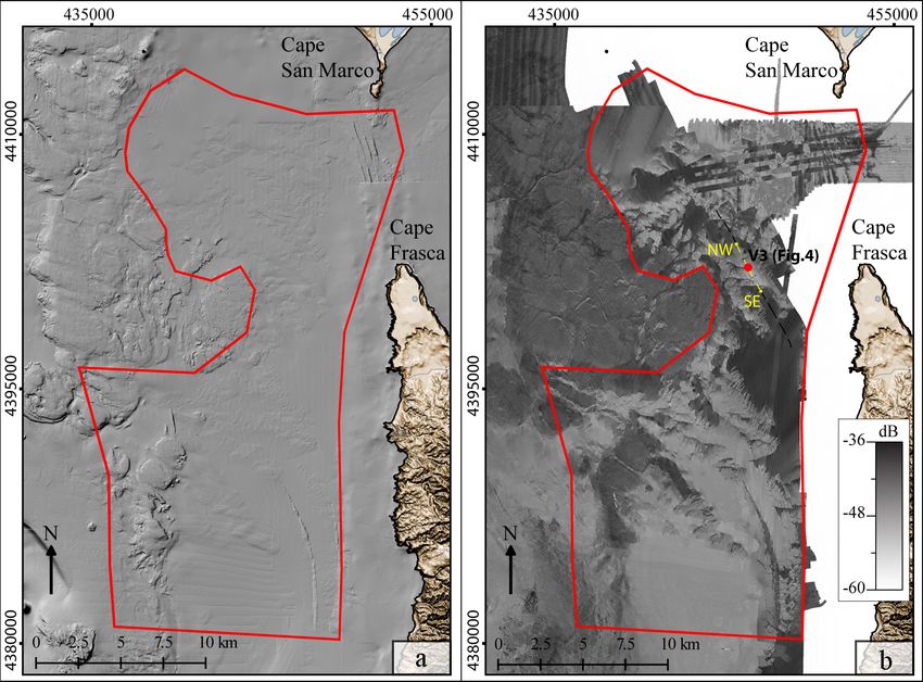
W. Brambilla et al.: Data set of submerged sand deposits 519
3.3 Sedimentological data
Sediment samples collected during the oceanographic
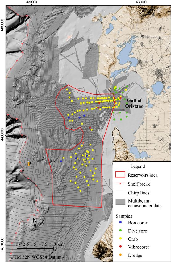
cruises (Fig. 2) cited above were used to characterise the
sandy sedimentary deposits. All 149 superficial sediment
samples were collected with a Van Veen grab and a Box
Corer, whereas five sediment cores up to 3 m long were col-
lected by using a vibrocorer (Fig. 2). In all samples, grain-
size distribution was measured using dry sieving for the
gravel/sand fraction between 4000 and 90 µm at half-phi in-
tervals. Multivariate statistical techniques were used to clas-
sify sediment samples into sedimentary facies (De Falco et
al., 2015; Brambilla et al., 2016; De Muro et al., 2017). The
statistical analysis of sediments data was performed by the
software GRADISTAT (Blott and Pye, 2011). Sedimentolog-
ical data provided the ground-truth observations used to clas-
sify the acoustic facies obtained by multibeam bathymetry
and backscatter data.
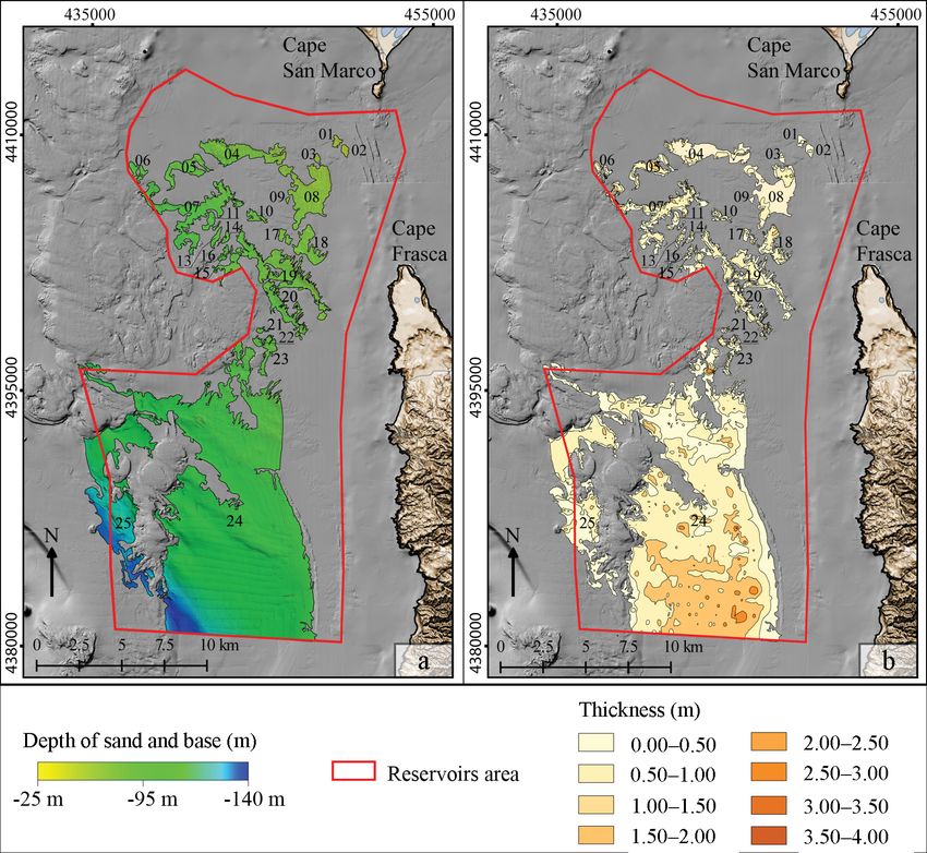
3.4 Thickness and volume computation
The model of the thickness of the SSD was created with the
GIS spatial analysis tools. The thickness was estimated by
subtracting the elevation value of each cell of the DTM of the
sand base surface from the corresponding cell of the DTM of
the seabed obtained through MBES surveys. The latter DTM
was increased from 2.5 to 10 m cell size. The volumes were
estimated from the digital map of the thickness of each de-
posit (Fig. 5) (Correggiari et al., 2013, 2016; Trobec et al.,
2018).
The recognised submerged sand deposits were classified
into seven hierarchic categories based on the volume of each
deposit as shown in Table 1. The margin of error of sediment
Figure 2. Locations of acquired data sets.
volume estimation was based on the vertical resolution of the
seismic data used for surface interpolation (i.e. 0,1 m).
The maps of seismic facies boundaries have been used
as key beds to define the lower limit of sand reservoirs, 4 Results
called the sand base (Fig. 4). The sand base is the unconfor-
mity which separates the transgressive sands deposited dur- 4.1 Seabed morphology
ing the Holocene from the underlying Pleistocene sediments The seabed features of the continental shelf of central–
or Miocene-to-Pliocene bedrock. western Sardinia, including the distribution of rocky out-
The shape of the sand base surface was obtained by inter- crops, sedimentary facies and seagrass meadows is shown
polating the depth values (referred to the present sea level) in Fig. 6. The map was obtained integrating the geophysical
of the surface, from each seismic lines, in order to obtain the and sedimentological data with the map of seagrass meadow
digital terrain model’s 10 m cell size of the bottom of sand of Sardinia (Ministry of Environment Land and Sea, 2002),
deposits. realised in 2002 by the Italian Ministry of Environment Land
The conversion of two-way travel time to real depth was and Sea.
obtained by assuming an average velocity of about 1550 ms The outcropping and rocky basement were recognised
within the first 300 ms of the seismic record below the sea mainly in the shelf sector facing the Sinis Peninsula and the
floor (Carlson et al., 1986; Budillon et al., 2011). The vertical Gulf of Oristano down to 150 m in depth. About 40 vol-
resolution of seismic data is 0.1 m. canic cone mounds, subcircular in plain view (Fig. 6), were
recognised on the high-resolution DTM in a sector of approx.
40 × 20 km2 (Conforti et al., 2016).
Sedimentary basins fill the depressions of the bedrock
along the inner shelf. The backscatter data indicate a sharp
www.earth-syst-sci-data.net/11/515/2019/ Earth Syst. Sci. Data, 11, 515–527, 2019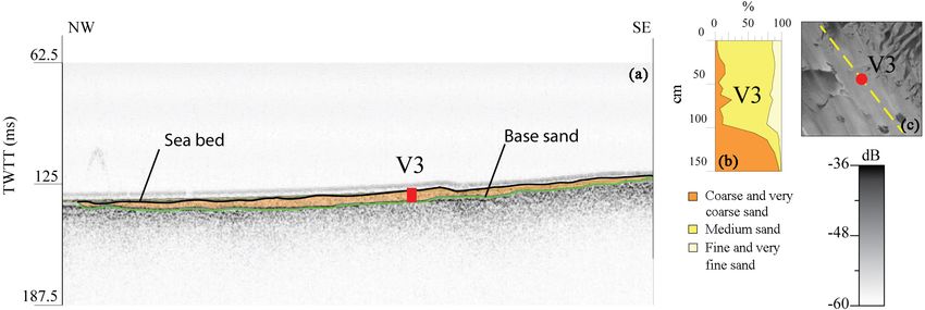
520                                                                             W. Brambilla et al.: Data set of submerged sand deposits

Figure 3. (a) Shaded relief map of a digital terrain model of the study sector; (b) distribution of relative backscatter intensity values of the
same sector.

Figure 4. (a) Example of digitisation of the sand base in a chirp profile which is correlated with the core V3; (b) stratigraphic profile of the
cores located on the chirp profile; (c) relative backscatter intensity value.

acoustic contrast of the sedimentary deposits along the                         limits of the finer sediments, which correspond to the trans-
basins. The sector reported in Fig. 1 (150 km2 , 25 to 140 m                    gressive sand layer deposit during the last sea level rise.
in depth) was considered the more interesting for the anal-
ysis of SSD. Backscatter data, calibrated with sedimentary                      4.2   Submerged sand deposit
data, revealed an alternation of low and high backscatter val-
ues that reveal the presence of finer sediments alternating                     The features of sand deposits are shown in Table 1. The
with coarse sediments: this sedimentary pattern is associated                   sedimentological analysis allowed us to characterise the
with the presence of sorted bedforms (De Falco et al., 2015).                   study area and sand reservoirs. Four textural and compo-
Lower backscatter values allowed us to identify the spatial                     sitional groups were recognised: (i) muddy sands (CaCO3
                                                                                66 ± 8 %), (ii) fine sands (CaCO3 63 ± 17 %), (iii) medium
                                                                                sands (CaCO3 43 ± 29 %) and (iv) sandy gravels (CaCO3

Earth Syst. Sci. Data, 11, 515–527, 2019                                                        www.earth-syst-sci-data.net/11/515/2019/
W. Brambilla et al.: Data set of submerged sand deposits 521 Figure 5. (a) Digital terrain model of the sand base; (b) thickness map of submerged sand deposits (SSDs). 14 ± 11 %) (see De Falco et al., 2015 for the sedimentary been estimated at 130 000 Mm3 . An identification number facies classification). This subdivision is also of a spatial na- (id_n) has been associated with each deposit (Table 1). ture, with the muddiest sediments located in the southern- The deposits were classified into several categories to fa- most sector of the investigated area, the fine sands corre- cilitate data management and description. Eight deposit cat- sponding to the areas occupied by sorted bedforms and the egories (named Type n) are recognised based on the volume medium sands located at the mouth of the Gulf of Oristano. of the single deposit: The muddy sands were not considered to be potential SSDs due to the high average mud content (24 ± 11 %). Fine – Type 1 (volume < 0.001 Mm3 ) consist of four deposits and medium sands were fully characterised because those de- (id_01, id_02, id_03 and id_09) that have irrelevant vol- posits were sampled by vibrocorers. Consequently, the SSDs umes of less than 1000 m3 each and thicknesses be- reported in this work are mixed fine and medium sand forms tween 0.5 and 1 m. These small deposits, composed with available geophysical and sedimentological data. mainly of fine sand, have been mapped to complete the The stratigraphy of mixed fine and medium sand shows characterisation of SSDs in the studied area. the presence of a few metres of acoustically transparent sed- – Type 2 (volume 0.01 < 0.06 Mm3 ) is composed of imentary cover, superimposed on a thicker layer formed by six deposits (id_04, id_08, id_12, id_14, id_16 and sandy gravel. id_21), has a total volume of 0.166 Mm3 , correspond- Twenty-five mixed fine and medium sand deposits have ing to 0.1 % of the total volume detected and has thick- been detected for a total surface of 148 km2 (Fig. 5). The ness c, and ranges from 0.50 to 2 m. The deposits of this thickness reaches 4 m but is mostly in the range of 1 to 2 m. group cover an area of about 9.8 km2 and consist mainly The total volume of the superficial sedimentary bodies has of fine and medium-fine sand. www.earth-syst-sci-data.net/11/515/2019/ Earth Syst. Sci. Data, 11, 515–527, 2019
522                                                                 W. Brambilla et al.: Data set of submerged sand deposits

Table 1. Submerged sand deposit features.

                      Name_id     Perimeter   Surface                    Volume    Sand class (Folk and   Type
                                      (km)     (km2 )                      (m3 )   Ward, 1957)
                      01               2.7      0.24           < 1 × 10³ ± 100     Fine sand                1
                      02               2.0      0.22           < 1 × 10³ ± 100     Fine sand                1
                      03               2.0      0.16           < 1 × 10³ ± 100     Fine sand                1
                      04               2.2      3.95           3.7 × 10³ ± 370     Medium fine sand         2
                      05              13.0      1.88      1285 × 103 ± 120 000     Medium fine sand         4
                      06               6.5      0.54        312 × 103 ± 30 000     Medium fine sand         3
                      07              45.8      5.95      3600 × 103 ± 360 000     Medium fine sand         5
                      08              20.0      5.54           16 × 103 ± 1600     Fine sand                2
                      09               1.0      0.05           < 1 × 10³ ± 100     Fine sand                1
                      10               5.7      0.43        146 × 103 ± 14 000     Fine sand                3
                      11               3.5      0.41        161 × 103 ± 16 000     Fine sand                3
                      12               1.8      0.07           13 × 103 ± 1300     Fine sand                2
                      13               3.5      0.32        115 × 103 ± 11 500     Fine sand                3
                      14               2.7      0.19           56 × 103 ± 5500     Fine sand                2
                      15               3.6      0.27        110 × 103 ± 11 000     Fine sand                3
                      16               1.2      0.04           7.6 × 10³ ± 760     Fine sand                2
                      17               4.1      0.37        115 × 103 ± 11 500     Fine sand                3
                      18              12.1      1.83      1118 × 103 ± 111 000     Fine sand                4
                      19              65.5      6.53      3003 × 103 ± 300 000     Fine sand                5
                      20              29.1      2.12       1021 × 103 ± 10 000     Fine sand                4
                      21               2.6      0.13           36 × 103 ± 3600     Fine sand                2
                      22               2.5      0.21        127 × 103 ± 12 000     Fine sand                3
                      23              11.0      0.96        322 × 103 ± 30 000     Fine sand                3
                      24             165.3    103.35    11038 × 103 ± 1 104 000    Fine/very fine sand      7
                      25              72.5     16.32      8471 × 103 ± 800 000     Fine/very fine sand      6

  – Type 3 (volume 0.10 < 0.35 Mm3 ) consists of eight de-              – Type 7 (> 100 Mm3 ) is represented by the biggest sin-
    posits (id_6, id_10, id_11, id_13, id_15, id_17, id_22                gle deposit (id_24), which, with its 110 Mm3 , represents
    and id 23) that contain 0.11 to 0.32 Mm3 each, for a total            85 % of the total volume measured. It covers an area of
    of 1.41 Mm3 . They cover an area of about 3.6 km2 and                 104 km2 and the thickness varies from 0.5 to 4 m. The
    range from very fine to medium sand textural groups.                  sands of this deposit belong to the fine and very fine
                                                                          dimensional classes.
  – Type 4 (1.000 < 1.300 Mm3 ) consists of three deposits
    (id_05, id_18 and id_20) made up of over 1 Mm3 each,
                                                                    5    Data availability
    for a total of 3424 Mm3 . They have a total surface of
    6.6 km2 and are characterised by thicknesses ranging
                                                                    The data set described in this study is publicly available and
    from 0.50 to 3 m. These deposits are characterised by
                                                                    free of charge from the PANGAEA data repository (Bram-
    fine sands.
                                                                    billa et al., 2018). The data set presented is from WGS 84 /
                                                                    UTM zone 32N and is composed of all data needed to char-
  – Type 5 (3.00 < 4.00 Mm3 ) consists of two deposits.
                                                                    acterise the SSDs, as well as the SSD features themselves.
    The first (id_07) from 3.6 Mm3 and the second from
    3 Mm3 (Id_19). The two deposits are developed for
    about 14.6 km2 and are characterised by thicknesses             6    Discussion and conclusion
    ranging from 0.5 to 3 m, consisting of fine and medium-
    fine sands.                                                     Decision makers who face managing SSDs need knowledge
                                                                    that can be derived from a complex data set of geophysical
  – Type 6 is represented by a single deposit (id_25) of            and sedimentological data: in this work, we provided an ex-
    8.5 Mm3 , spread over an area of 16.8 km2 . The thick-          ample of organisation of such knowledge, collected and de-
    ness of this deposit varies from 0.5 to 2 m. The weaving        livered in a useful online fashion. A wide portion of the con-
    class of sands from fine to very fine.                          tinental shelf of Western Sardinian margin has been investi-

Earth Syst. Sci. Data, 11, 515–527, 2019                                              www.earth-syst-sci-data.net/11/515/2019/
W. Brambilla et al.: Data set of submerged sand deposits 523 Figure 6. Map of seabed features of the continental shelf of central–western Sardinia. gated. Along this area, several SSDs were detected and char- races characterised by a distinct clinoform pattern and were acterised in terms of grain size, stratigraphy, composition and considered as transgressive deposits related to the last sea available volume. level rise (Carboni et al., 1989; De Falco et al., 2015). This deposition area of SSDs is located in a small struc- The compatibility of SSDs with beach sediment of the ad- tural basin limited by a rocky outcrop and mainly formed jacent coastal area is limited to a few sectors due to the great by volcanic mounds from the early Pliocene (Conforti et al., heterogeneity of beach sediment grain size and composition 2016 and reference therein). (De Falco et al., 2017, 2014, 2003). In particular, beaches The mixed fine and medium sands derive from the mixing located along the coast, ranging from the northern sector of and winnowing of siliciclastic riverine sediments (De Falco the Gulf of Oristano to Cape Mannu, generally show a mixed et al., 2015) with bioclastic sediments derived from marine composition with variable percentages of biogenic carbonate benthic ecosystems (Posidonia oceanica and coralligenous sediments. Some of these beaches are characterised by fine assemblages) (De Falco et al., 2017). The fine and medium and medium sand grains, which are fully compatible with sand deposits are associated with submerged depositional ter- the identified SSDs. www.earth-syst-sci-data.net/11/515/2019/ Earth Syst. Sci. Data, 11, 515–527, 2019
524                                                               W. Brambilla et al.: Data set of submerged sand deposits

   This low degree of similarity can be attributed to the dif-    Author contributions. WB interpreted geophysical data, mod-
ferent processes which sorted beach and offshore sediments:       elled the surfaces and thickness, mapped the seabed features, pre-
the former is characterised by extremely variable composi-        pared the figures, wrote the manuscript and managed data and meta-
tion and grain size (De Falco et al., 2003) due to specific       data handling on the online repository. AC acquired and processed
local conditions (coastal morphology and geology, nearshore       the multibeam data set and the seismic profiles and managed data
                                                                  and metadata handling on the online repository. SS, acquired and
carbonate factories) which enhance strong coastal compart-
                                                                  processed the multibeam, seismic and sedimentological data in var-
mentalisation (Sanderson and Eliot, 1999); the latter were        ious campaigns and contributed in writing the manuscript. PC and
probably selected under similar conditions driven by shelf        SL developed the interoperable system based on the software suite
hydrodynamics.                                                    Geoinformation Enabling Toolkit StarterKit® (GET-IT). GDF con-
   In addition, the evaluation of similarity must take into ac-   ceived and managed the study, processed data and contributed in
count other parameters (e.g. sediment colour, grain round-        writing the manuscript.
ness, mineralogy) that we do not evaluate in this work.
Those sediment features are particularly important for pris-
tine coastal sectors, such as the Western Sardinia coast,         Competing interests. The authors declare that they have no con-
where the specific beach sediment typology is a fundamental       flict of interest.
component of the coastal landscape.
   The future policy of coastal area and the marine spatial
plans will be driven by the expected sea level rise (Finkl and    Acknowledgements. The data of the present study were col-
Khalil, 2005; Armstrong et al., 2015; Barbanti et al., 2015;      lected within the framework of the MAGIC project (Marine Geo-
Brown et al., 2016), which will strongly influence the mea-       hazards along Italian Coasts) and the RITMARE project CNR (Sub-
                                                                  project SP4, Work-Package 1, Actions 1, 2). The interoperable sys-
sures of protection against coastal flooding (Marchand et al.,
                                                                  tem development activities have been funded by the RITMARE
2011; Mcglade et al., 2017).
                                                                  project. The authors are grateful to referees Jorge Guillen and An-
   Furthermore, as recommended by several projects funded         namaria Correggiari for their helpful suggestions.
by the European Union Commission (EUROSION; Con-
science, Micore), the recognition and classification of strate-
gic sediment reservoirs that can be used as a sediment supply     Review statement. This paper was edited by Kirsten Elger and
for mitigation measures to contrast climate change are the        reviewed by Annamaria Correggiari and Jorge Guillen.
basic concepts of coastal erosion management (Marchand et
al., 2011).
   In this context, knowledge of the location and character-      References
isation of SSDs will be fundamental for planning the sand
reservoir exploitation, which is used to plan coastal nourish-    Antonioli, F., Anzidei, M., Amorosi, A., Lo Presti, V., Mastronuzzi,
ment as protection against flooding.                                G., Deiana, G., De Falco, G., Fontana, A., Fontolan, G., Lisco,
   This operation had to take into account the possible neg-        S., Marsico, A., Moretti, M., Orrù, P. E., Sannino, G. M., Serpel-
ative impact on the marine ecosystems and characterisation          loni, E., and Vecchio, A.: Sea-level rise and potential drowning
and monitoring studies before, during and after the dredging.       of the Italian coastal plains: Flooding risk scenarios for 2100,
The sediment handling and nourishment activities should be          Quaternary Sci. Rev., 158, 29–43, 2017.
                                                                  Arisci, A., De Waele, J., Di Gregorio, F., Ferrucci, I., and Follesa,
recommended to evaluate and minimise the potential impacts
                                                                    R.: Geoenvironmental analysis in coastal zone management: a
of these operations on the marine environment. For these rea-
                                                                    case of study in Southwest-Sardinia (Italy), J. Coastal Res., 19,
sons and to guarantee sustainable and long-term exploitation        963–970, 2003.
of non-renewable resource of SSDs, it is important to intro-      Armstrong, J., Wilby, R., and Nicholls, R. J.: Climate change
duce the management of instruments focused on geological            adaptation frameworks: an evaluation of plans for coastal
and physical characteristics of the sandy deposit, particu-         Suffolk, UK, Nat. Hazards Earth Syst. Sci., 15, 2511–2524,
larly those concerning the environmental data acquired for          https://doi.org/10.5194/nhess-15-2511-2015, 2015.
the management and monitoring of the exploitation of the          Barbanti, A., Campostrini, P., Musco, F., Sarretta, A., and Gissi,
submerged marine sand resource (Nicoletti et al., 2018).            E.: Developing a Maritime Spatial Plan for the Adriatic-Ionian
   Well-curated, federated sources of data set, organised in        Region, CNR-ISMAR, https://doi.org/10.5281/zenodo.48231,
SDI, are strategic for providing a means to support exploita-       2015.
                                                                  Blott, S. J. and Pye, K.: GRADISTAT: A grain size distri-
tion strategies and the projects that provide use and monitor-
                                                                    bution and statistics package for the analysis of unconsol-
ing of dredging, both during and after mining.                      idated sediments, Earth Surf. Proc. Land., 26, 1237–1248,
   To conclude, this work summarises a large data set of geo-       https://doi.org/10.1002/esp.261, 2011.
physical and sedimentological data in order to map the spa-       Brambilla, W., van Rooijen, A., Simeone, S., Ibba, A., and De
tial features of submerged sand deposits, which are useful for      Muro, S.: Field observations, coastal video monitoring and nu-
coastal management at present and in future climate change          merical modeling at Poetto Beach, Italy, J. Coastal Res., 75, 825–
scenarios.                                                          829, https://doi.org/10.2112/SI75-166.1, 2016.

Earth Syst. Sci. Data, 11, 515–527, 2019                                               www.earth-syst-sci-data.net/11/515/2019/
W. Brambilla et al.: Data set of submerged sand deposits 525 Brambilla, W., Conforti, A., Simeone, S., Carrara, P., Lanu- tema Informativo per l’utilizzo della risorsa Sabbia offshore cara, S., and De Falco, G.: Submerged sand deposits nei progetti di protezione costiera: geodatabase in_Sand, data from Western Sardinia, Mediterranean Sea organised Servizio Geologico Sismico e dei Suoli, Regione Emilia Ro- in an interoperable Spatial Data Infrastructure, PANGAEA, magna, technical report, available at: https://ambiente.regione. https://doi.org/10.1594/PANGAEA.895430, 2018. emilia-romagna.it/it/geologia/temi/costa/pdf/in_sand_web.pdf Brown, J. M., Ciavola, P., Masselink, G., McCall, R., and Plater, A. (last access: 11 April 2019), 2016. J.: Preface: Monitoring and modelling to guide coastal adapta- De Falco, G., Molinaroli, E., Baroli, M., and Bellacicco, S.: Grain tion to extreme storm events in a changing climate, Nat. Hazards size and compositional trends of sediments from Posidonia Earth Syst. Sci., 16, 463–467, https://doi.org/10.5194/nhess-16- oceanica meadows to beach shore, Sardinia, Western Mediter- 463-2016, 2016. ranean, Estuar. Coast. Shelf S., 58, 299–309, 2003. Budillon, F., Conforti, A., Tonielli, R., De Falco, G., Di Martino, G., De Falco, G., Baroli, M., Cucco, A., and Simeone, S.: Intrabasinal Innangi, S., and Marsella, E.: The Bulgheria canyon-fan A small- conditions promoting the development of a biogenic carbonate scale proximal system in the eastern Tyrrhenian Sea (Italy), Mar. sedimentary facies associated with the seagrass Posidoniaocean- Geophys. Res., 32, 83–97, 2011. ica, Cont. Shelf Res., 28, 797–812, 2008. Carboni, S., Lecca, L., and Ferrara, C.: La discordanza versiliana De Falco, G., Tonielli, R., Di Martino, G., Innangi, S., Simeone, S., sulla piattaforma occidentale della Sardegna, B. Soc. Geol. Ital., and Parnum, I. M.: Relationships between multibeam backscat- 108, 503–519, 1989. ter, sediment grain size, and Posidonia oceanica seagrass distri- Carlson, R. L., Gangi, A. F., and Snow, K. L. R.: Empirical reflec- bution, Cont. Shelf Res., 30, 1941–1950, 2010. tion travel time versus depth and velocity versus depth functions De Falco, G., Budillon, F., Conforti, A., De Muro, S., Di Martino, for the deep sea sediments column, J. Geophys. Res., 91, 8249– G., Innangi, S., Perilli, A., Tonielli, R., and Simeone, S.: Sandy 8266, 1986. beaches characterization and management of coastal erosion on Casula, G., Cherchi, A., Montadert, L., Murru, M., and Sarria, E.: western Sardinia island (Mediterranean sea), J. Coastal Res., 70, The Cenozoic graben system of Sardinia (Italy): geodynamic 395–400, 2014. evolution from new seismic and field data, Mar. Pet. Geol., De Falco, G., Budillon, F., Conforti, A., Di Bitetto, A., Di Martino, 18, 863–888, https://doi.org/10.1016/S0264-8172(01)00023-X, G., Innangi, S., Simeone, S., and Tonielli R.: Sorted bedforms 2001. over transgressive deposits along the continental shelf of western Church, J. A., Clark, P. U., Cazenave, A., Gregory, J. M., Jevrejeva, Sardinia (Mediterranean Sea), Mar. Geol., 359, 75–88, 2015. S., Levermann, A., Merrifield, M. A., Milne, G. A., Nerem, R. De Falco, G., Molinaroli, E., Conforti, A., Simeone, S., and Tonielli, S., Nunn, P. D., Payne, A. J., Pfeffer, W. T., Stammer, D., and R.: Biogenic sediments from coastal ecosystems to beach–dune Unnikrishnan, A. S.: Sea level change, in: Climate Change 2013: systems: implications for the adaptation of mixed and carbonate the Physical Science Basis, Contribution of Working Group I to beaches to future sea level rise, Biogeosciences, 14, 3191–3205, the Fifth Assessment Report of the Intergovernmental Panel on https://doi.org/10.5194/bg-14-3191-2017, 2017. Climate Change, Cambridge University Press, Cambridge, UK De Muro, S., Ibba, A., Simeone, S., Buosi, C., and Bram- and New York, NY, USA, 2013. billa, W.: An integrated sea-land approach for mapping Ciavola, P., Ferreira, Ã., Haerens, P., van Koningsveld, M., geomorphological and sedimentological features in an ur- Armaroli, C., and Lequeux, Q.: Storm impacts along Eu- ban microtidal wave-dominated beach: a case study from ropean coastlines. Part 1: The joint effort of the MI- S Sardinia, western Mediterranean, J. Maps, 13, 822–835, CORE and ConHaz Projects, Environ. Sci. Pol., 14, 912–923, https://doi.org/10.1080/17445647.2017.1389309, 2017. https://doi.org/10.1016/j.envsci.2011.05.011, 2011. Desprez, M.: Physical and biological impact of marine aggregate Conforti, A., Budillon, F., Tonielli, R., and De Falco, G.: A newly extractionalong the French coast of the Eastern English Channel: discovered Pliocene volcanic field on the western Sardinia con- short and long term post dredging restoration, ICES J. Mar. Sci., tinental margin (western Mediterranean), Geo.-Mar. Lett., 36, 1– 57, 1428–1438, 2000. 14, https://doi.org/10.1007/s00367-015-0428-0, 2016. Emery, K. O.: Relict sediments on continental shelves of the world, Correggiari, A., Perini, L., Foglini, F., Remia, A., Campiani, E., Am. Assoc. Petr. Geol. B., 52, 445–464, 1968. Calabrese, L., Luciani, P., Martini, A., Trincardi, F., and Pignone, Erftemeijer, P. L. A., Riegl, B., Hoeksema, B. W., and Todd, P. A.: R.: InSAND_Sistema_Informativo_Sabbie_Offshore_web Environmental impacts of dredging and other sediment distur- online, available at: http://ambiente.regione.emilia- bances on corals: a review, Mar. Pollut. Bull., 64, 1737–1765, romagna.it/geologia/temi/costa/sistema-informativo-per-la- 2012. gestione-dei-depositi-di-sabbia-sommersi (last access: 11 April Eurosion: A guide to coastal erosion management practices in Eu- 2019), 2012. rope, Eurosion project, 30 June 2004, available at: http://www. Correggiari, A., Remia, A., Foglini, F., Grande, V., Nicoletti, L., eurosion.org (last access: 11 April 2019), 2014. Perini, L., Piazza, R., and Bertaggia, R.: Research and exploita- Fais, S., Klingele, E. E., and Lecca, L.: Oligo-Miocene half graben tion of shelf marine sand deposit for coastal nourishment: geo- structure in western Sardinian Shelf (western Mediterranean): re- database guidelines from northern Adriatic Shelf experience, flection seismic and aeromagnetic data comparison, Mar. Geol., SHAPE – Shaping an Holistic Approach to Protect the Adriatic 133, 203–222, https://doi.org/10.1016/0025-3227(96)00030-8, Environment between coast and sea, IPA Project, Final meeting, 1996. 16–17 October 2013, Lignano, Italy, 2013. Finkl, C. W. and Khalil, S.: Offshore exploration for sand sources: Correggiari, A., Perini, L., Remia, A., Luciani, P., Foglini, F., General guidelines and procedural strategies along deltaic coasts, Grande, V., Moscon, G., Calabrese, L., and Lorito, S.: Sis- J. Coastal Res., 44, 203–233, 2005. www.earth-syst-sci-data.net/11/515/2019/ Earth Syst. Sci. Data, 11, 515–527, 2019
526                                                                       W. Brambilla et al.: Data set of submerged sand deposits

Finkl, C. W. and Walker, H. J.: Beach Nourishment, Encyclope-             Lanucara, S., Oggioni, A., Modica, G., and Carrara, P.: Interoper-
   dia of Coastal Science, Encyclopedia of Earth Science Series,            able Sharing and Visualization of Geological Data and Instru-
   Springer, Dordrecht, the Netherlands, ISBN 978-1-4020-1903-6,            ments: A Proof of Concept, Computational Science and Its Ap-
   2005.                                                                    plications – ICCSA 2017, Lecture Notes in Computer Science,
Folk, R. L. and Ward, W.: Brazos river bar: A study in the signif-          10407, https://doi.org/10.1007/978-3-319-62401-3_42, 2017.
   icance of grain size parameters, J. Sediment. Petrol., 27, 3–26l,      Lecca, L.: La piattaforma continentale miocenico-quaternaria del
   1957.                                                                    margine occidentale sardo: blocco diagramma sezionato, Ren-
Fraser, M. W., Short, J., Kendrick, G., McLean, D., Keesing, J.,            diconti Seminario Facoltà di Scienze Università di Cagliari, 70,
   Byrne, M., Caley, J., Clarke, D., Davis, A. R., Erftemeijer, P. L.       49–70, 2000.
   A., Field, S., Gustin-Craig, S., Huisman, J., Keough, M., Lavery,      Lecca, L., Carboni, S., Scarteddu, R., Sechi, F., Tilocca, G., and
   P. S., Masini, R., McMahon, K., Mengersen, K., Rasheed, M.,              Pisano, S.: Schema stratigrafico della piattaforma continentale
   Statton, J., Stoddart, J., and Wu, P.: Effects of dredging on criti-     occidentale e meridionale della Sardegna, Memorie Società Ge-
   cal ecological processes for marine invertebrates, seagrasses and        ologica Italiana, 36, 31–40, 1986.
   macroalgae, and the potential for management with environmen-          Marchand, M., Sanchez-Arcilla, A., Ferreira M., Gault, J., Jiménez,
   tal windows using Western Australia as a case study, Ecol. In-           J. A., Markovic, M., Mulder, J., van Rijn, L., Stanic, A.,
   dic., 78, 229–242, https://doi.org/10.1016/j.ecolind.2017.03.026,        Sulisz, W., and Sutherland, J.: Concepts and science for
   2017.                                                                    coastal erosion management an introduction to the CON-
Fugazza, C., Oggioni, A., and Carrara, P.: RITMARE:                         SCIENCE framework, Ocean Coast. Manage., 54, 859–866,
   Linked Open Data for Italian Marine Research”, ERCIM-                    https://doi.org/10.1016/j.ocecoaman.2011.06.005, 2011.
   News, No. 96 (January 2014), 17–18, ISSN 0926-4981,                    MATTM-Regioni: Linee Guida per la Difesa della Costa dai
   available       at:       http://ercim-news.ercim.eu/en96/special/       fenomeni di Erosione e dagli effetti dei Cambiamenti climatici.
   ritmare-linked-open-data-for-italian-marine-research           (last     Versione 2018 – Documento elaborato dal Tavolo Nazionale
   access: 11 April 2019), 2014.                                            sull’Erosione Costiera MATTM-Regioni con il coordinamento
Gault, J., O’Hagan, A. M., Cummins, V., Murphy, J., and Vial, T.:           tecnico di ISPRA, 305 pp., 2018.
   Erosion management in Inch beach, South West Ireland, Ocean            Mcglade, K., Barquet, K., Bogaard, T., Ciavola, P., van Dongeren,
   Coast. Manage., 54, 930–942, 2011.                                       A., Ferreira, Ã., Higgins, R., Martinez, G., McCall, R., Stell-
Grande, V., Proietti, R., Foglini, F., Remia, A., Correggiari,              jes, N., and Viavatenne, C.: Resilience-Increasing Strategies for
   A., Paganelli, D., Targusi, M., Franceschini, G., La Valle,              Coasts – toolKIT (RISC-KIT), Synthesis Report, Middlesex Uni-
   P., Berducci, M.T., La Porta, B., Lattanzi, L., Lisi, I.,                versity London, project report Risk-kit project, available at: http:
   Maggi, C., Loia, M., Pazzini, A., Gabellini, M., and Nico-               //eprints.mdx.ac.uk/21860/ (last access: 11 April 2019), 2017.
   letti L.: Sistema Informativo per il monitoraggio ambi-                Mengel, M., Levermann, A., Frieler, K., Robinson, L., Marzeion,
   entale della risorsa sabbia offshore nei progetti di pro-                B., and Winkelmann, R.: Future sea level rise constrained by ob-
   tezione costiera: geodatabase Env_Sand. ISPRA, Manuali e                 servations and long-term commitment, P. Natl. Acad. Sci. USA,
   Linee guida, 127/2015, 63 pp., ISBN 978-88-448-0742-9,                   113, 2597–2602, 2016.
   available at: http://www.isprambiente.gov.it/files/pubblicazioni/      Ministero Dell’Ambiente E Della Tutela Del Territorio: Mappatura
   manuali-lineeguida/MLG_127_15_env_SAND.pdf (last access:                 delle praterie di Posidonia oceanica lungo le coste della Sardegna
   11 April 2019), 2015.                                                    e delle piccole isole circostanti, Ministero dell’ambiente e tutela
Horton, B. P., Rahmstorf, S., Engelhart, S. E., and Kemp, A. C.:            del territorio e del mare, Rome, Italy, 2002.
   Expert assessment of sea-level rise by AD 2100 and AD 2300,            Mitchum Jr., R. M., Vail, P. R., and Sangree, J. B.: Seismic stratig-
   QuatSci. Rev., 84, 1–6, 2014.                                            raphy and global changes of sea level. Part 6. Stratigraphic inter-
Jiménez, J. A., Gracia, V., Valdemoro, H. I., Mendoza T., and               pretation of seismic reflection patterns in depositional sequences,
   Sánchez-Arcilla A.: Managing erosion-induced problems in NW              AAPG Mem., 26, 117–133, 1977.
   Mediterranean urban beaches, Ocean Coast. Manage., 54, 907–            Nicoletti, L., La Valle, P., Paganelli, D., Lattanzi, L., La Porta, B.,
   918, 2011.                                                               Targusi, M., Lisi, I., Loia, M., Maggi, C., Pazzini, A., Proietti,
Khalil, S. M. and Finkl, C. W.: Spoil or Resource? Managing sedi-           R., and Gabellini, M.: Aspetti ambientali del dragaggio di sab-
   ment for coastal restoration, J. Coastal Res., 64, Proceedings of        bie relitte a fini di ripascimento: protocollo di monitoraggio per
   the 11th International Coastal Symposium, Szczecin, Poland, 9–           l’area di dragaggio, ISPRA, Manuali e Linee Guida 72/2018, Isti-
   13 May 2011, 1433–1437, ISSN 0749-0208, 2011.                            tuto Superiore per la Protezione e la Ricerca Ambientale, Rome,
Kopp, R. E., Kemp, A. C., Bittermann, K., Horton, B. P., Donnelly,          Italy, 35 pp., 2018.
   J. P., Gehrels, W. R., Hay, C. C., Mitrovica, J. X., Morrow, E. D.,    Pavesi, F., Basoni, A., Fugazza, C., Menegon, S., Oggioni, A., Pepe,
   and Rahmstorf, S.: Temperature-driven global sea-level variabil-         M., Tagliolato, P., and Carrara, P.: EDI – A template-driven meta-
   ity in the Common Era, P. Natl. Acad. Sci. USA, 15, 1434–1441,           data editor for research data, Journal of Open Research Software,
   https://doi.org/10.1073/pnas.1517056113, 2016.                           4, e40, https://doi.org/10.5334/jors.106, 2016.
Lambeck, K., Antonioli, F., Anzidei, M., Ferranti, L., Leoni, G.,         Pranzini, E.: Coastal erosion and shore protection: A brief
   Scicchitano, G., and Silenzi, S.: Sea level change along Italian         historical analysis, J. Coast. Conserv., 22, 827–830,
   coast during Holocene and a projection for the future, Quatern.          https://doi.org/10.1007/s11852-017-0521-9, 2018.
   Int., 232, 250–257, https://doi.org/10.1016/j.quaint.2010.04.026,      PueyoAnchuela, O., Frongia, P., Di Gregorio, F., CasasSainz, A.,
   2011.                                                                    and Pocovì Juan, A.: Magnetometry and ground-penetrating
                                                                            radar surveys applied to tracing potential collectors of mining-

Earth Syst. Sci. Data, 11, 515–527, 2019                                                     www.earth-syst-sci-data.net/11/515/2019/
W. Brambilla et al.: Data set of submerged sand deposits 527 derived pollutants in coastal sediments (Piscinas Bay, Montevec- Simeone, S., De Falco, G., Quattrocchi, G., and Cucco., A.: Mor- chio mining area, SW Sardinia), Environ. Earth Sci., 76, 230, phological changes of a Mediterranean beach over oneyear (San https://doi.org/10.1007/s12665-017-6555-3, 2017. Giovanni di Sinis, western Mediterranean), J. Coastal Res., 70, Radermacher, M., Geerlof, W., de Schipper, M., Huisman, B., 217–222, 2014. Aarninkhof, S., and Reniers, A.: Evolution of alongshore bathy- Simeone, S., De Falco, G., Quattrocchi, G., Palombo, L., and metric variability around a mega-scale beach nourishment, in: Cucco, A.: Beaches morphological variability along a com- Proceedings of Coastal Dynamics 2017, edited by: Aagaard, T., plex coastline (Sinis Peninsula, western Mediterranean Sea), J. Deigaard, R., and Fuhrman, D., Helsingør, Denmark, 1370-1375, Coastal Res., 75, 1302–1306, 2016. 2017. Simeone, S., Molinaroli, E., Conforti, A., and De Falco, G.: Im- Rahmstorf, S.: A semi-empirical approach to projecting future sea- pact of ocean acidification on the carbonate sediment budget level rise, Science, 315, 368–370, 2007. of a temperate mixed beach, Climatic Change, 150, 227–242, Richards, J. A. and Nicholls, R. J.: Impacts of climate change https://doi.org/10.1007/s10584-018-2282-3, 2018. in coastal systems in Europe. PESETA-Coastal Systems study, Tingy, V., Ozer, A., De Falco, G., Baroli, M., and Djenidi, S.: Rela- European Commission, Institute for Prospective Technological tionship between the evolution of the shoreline and the Posido- Studies, Joint Research Centre EUR 24130 EN, ISBN 978-92- nia oceanica meadow limit in a Sardinian coastal zone, J. Coastal 79-14627-5, https://doi.org/10.2791/3558, 2009. Res., 23, 787–793, 2007. Rogers, C. S.: Responses of coral reefs and reef organisms to sedi- Trobec, A., Busetti, M., Zgur, F., Baradello, L., Babich, A., Cova, mentation, Mar. Ecol. Prog. Ser., 62, 185–202, 1990. A., Gordini, E., Romeo, R., Tomini, I., Poglajen, S., Diviacco, P., Sage, F., Von Gronefeld, G., Déverchère, J., Gaullier, V., Mail- and Vrabec, M.: Thickness of marine Holocene sediment in the lard, A., and Gorini, C.: Seismic evidence for Messinian detrital Gulf of Trieste (northern Adriatic Sea), Earth Syst. Sci. Data, 10, deposits at the western Sardinia margin, northwestern Mediter- 1077–1092, https://doi.org/10.5194/essd-10-1077-2018, 2018. ranean, Mar. Petrol. Geol., 22, 757–773, 2005. van Egmond, E. M., van Bodegom, P. M., Berg, M. P., Sánchez-Arcilla, A., Jiménez, J. A., and Marchand, M.: Managing Wijsman, J. W. M., Leewis, L., Janssen, G. M., and coastal evolution in a more sustainable manner. The Conscience Aerts, R.: A mega-nourishment creates novel habitat for approach, Ocean Coast. Manage., 54, 951–955, 2011. intertidal macroinvertebrates by enhancing habitat relief of Sanderson, P. G. and Eliot, I.: Compartmentalisation of beachface the sandy beach, Estuar. Coast. Shelf S., 207, 232–241, sediments along the southwestern coast of Australia, Mar. Geol., https://doi.org/10.1016/j.ecss.2018.03.003, 2018. 162, 145–164, 1999. Van Rijn, L. C.: Erosion of gravel/shingle beaches and barriers, EU- Simeone, S. and De Falco, G.: Morphology and composition of Project CONSCIENCE, Deltares, Delft, the Netherlands, 2010. beachcast Posidonia oceanica litter on beaches with different ex- posures, Geomorphology, 151–152, 224–233, 2012. www.earth-syst-sci-data.net/11/515/2019/ Earth Syst. Sci. Data, 11, 515–527, 2019
You can also read