Did You See Bob?: Human Localization using Mobile Phones
←
→
Page content transcription
If your browser does not render page correctly, please read the page content below
Did You See Bob?:
                         Human Localization using Mobile Phones

                 Ionut Constandache                                          Xuan Bao                         Martin Azizyan
                       Duke University                                   Duke University                      Duke University
                      Durham, NC, USA                                   Durham, NC, USA                      Durham, NC, USA
                  ionut@cs.duke.edu                                xuan.bao@duke.edu                  martin.azizyan@duke.edu

                                                                 Romit Roy Choudhury
                                                                         Duke University
                                                                        Durham, NC, USA
                                                                   romit@ee.duke.edu

ABSTRACT                                                                             faces and Presentation]: Group and Organization Interfaces—
Finding a person in a public place, such as in a library, confer-                    Collaborative Computing
ence hotel, or shopping mall, can be difficult. The difficulty
arises from not knowing where the person may be at that                              General Terms
time; even if known, navigating through an unfamiliar place                          Design, Experimentation, Measurement, Algorithms
may be frustrating. Maps and floor plans help in some occa-
sions, but such maps may not be always handy. In a small
scale poll, 80% of users responded that the ideal solution
                                                                                     Keywords
would be “to have an escort walk me to the desired person”.                          Localization, Mobile Phones, Sensors, Navigation

   This paper identifies the possibility of using mobile phone                       1.   INTRODUCTION
sensors and opportunistic user-intersections to develop an elec-                        The rapid growth in people-centric mobile computing appli-
tronic escort service. By periodically learning the walking                          cations has called for improved localization technology. The
trails of different individuals, as well as how they encounter                       desired improvement is not only in terms of localization accu-
each other in space-time, a route can be computed between                            racy, but also across multiple application-specific dimensions.
any pair of persons. The problem bears resemblance to rout-                          For instance, (1) authors in [9, 14, 16, 19, 27, 33, 36] have
ing packets in delay tolerant networks, however, its applica-                        drawn attention to the tradeoff between energy and location
tion in the context of human localization raises distinct re-                        accuracy. The main observation is that while GPS is fairly ac-
search challenges. We design and implement Escort, a system                          curate, its continuous usage can drain a phone’s battery in
that guides a user to the vicinity of a desired person in a public                   less than 8 hours. Alternative WiFi/GSM based schemes of-
place. We only use an audio beacon, randomly placed in the                           fer longer battery life, but at the expense of lower accuracy.
building, to enable a reference frame. We do not rely on GPS,                        (2) In another thread of research, authors argue today’s in-
WiFi, or war-driving to locate a person – the Escort user only                       door localization techniques are inadequate because they ei-
needs to follow an arrow displayed on the phone. Evaluation                          ther require special infrastructure, or rely on continuous war-
results from experiments in parking lots and university build-                       driving. They propose collaborative methods by which mul-
ings show that, on average, the user is brought to within 8m                         tiple devices can determine the WiFi placement in the build-
of the destination. We believe this is an encouraging result,                        ing [17], or infer their relative locations with zero WiFi de-
opening new possibilities in mobile, social localization.                            pendence [4, 24]. (3) Breaking away from coordinate-based
                                                                                     localization, authors in [2, 28, 29] propose ways to identify
                                                                                     logical locations (Starbucks, Wal-mart, RadioShack), as op-
Categories and Subject Descriptors                                                   posed to physical coordinates (as in GPS). The rationale is
C.2.4 [Computer-Communication Networks]: Distributed                                 that a large class of applications do not care about the lati-
Systems—Distributed Applications; H.5.3 [Information Inter-                          tude/longitude of the user; instead they desire to know the
                                                                                     “place” where the user is located. These and several other
                                                                                     works [1, 7, 8] emphasize the broad and evolving nature of
                                                                                     localization technology, driven primarily by the fast changing
Permission to make digital or hard copies of all or part of this work for            landscape of mobile, pervasive, people-centric computing.
personal or classroom use is granted without fee provided that copies are
not made or distributed for profit or commercial advantage and that copies             In this paper, we expand the notion of localization to the
bear this notice and the full citation on the first page. To copy otherwise, to      social context. We describe the problem with a hypothetical
republish, to post on servers or to redistribute to lists, requires prior specific   scenario. Imagine that MobiCom 2010 is in progress in a big
permission and/or a fee.
MobiCom’10, September 20–24, 2010, Chicago, Illinois, USA.                           hotel in Chicago, and as Alice arrives, she intends to meet up
Copyright 2010 ACM 978-1-4503-0181-7/10/09 ...$10.00.                                with her friend, Bob. The general approach today is to either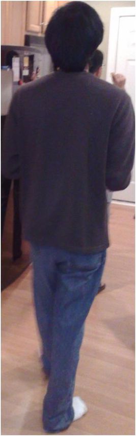
stroll around in the hotel until Alice can visually spot Bob, or
to ask “have you seen Bob around?”. A phone call may be a                                       B (t0)
third option, but sometimes inappropriate because Bob might                                                         TBC
be in an important meeting or attending a technical session.
Even if Bob answers the phone, he may ask Alice to come over
by the swimming pool, leaving Alice to locate and navigate to                                 TAC
the (unknown) destination. Navigating through a big con-
ference hotel, especially without precise knowledge of Bob’s
location, may not be a trivial task. Moreover, Bob himself
might be moving, potentially making the exercise frustrating.
An ideal solution would be to have a third person know the
                                                                            C (t0)          A (t0)
location of Bob, who can then escort Alice to him.
                                                                        Figure 1: The Escort server assimilates a global view of
   When presented with an informal questionnaire, 80% of                users’ movement and intersection patterns. The human
the participants agreed that an escorting system would be the           icons show the current location of the user U , while U (t0 )
easiest option; some people shared anecdotes and frustrations           denotes user U ’s first recorded location. TU V denotes the
in trying to find an individual in a hospital or a library. Moti-       intersection time of users U and V .
vated by this, we generalize the hypothetical scenario above
to a broader problem space. We ask, in a human populated                gets reset. Additionally, when this repositioned user (X) en-
public place, can we develop an electronic system that can lo-          counters other users (for some time in the future), the other
calize and route a person A to a specified person B. This form          users can correct their own positions by exploiting the obser-
of localization and routing can become a primitive for social           vation that X has a reasonably good estimate of her own loca-
computing applications, useful in public settings such as air-          tion. In general, while the system error grows with time, the
ports, shopping malls, libraries, museums, and universities.            encounters among users and beacon help in keeping the error
We show the basic feasibility of such a system, called Escort,          under control. Encounter detection is achieved by audio sig-
and evaluate its performance in real life scenarios.                    naling; the fixed beacon and all phones periodically transmit
                                                                        audio tones to make their presence known. Together, these
   The core idea with Escort is simple. Mobile phones capture           building blocks are consolidated into a prototype system im-
users’ “movement traces” using accelerometer and compass                plemented on a mix of Nokia and Google Android phones.
measurements. When other phones are in the vicinity, each               Experiment results with real users exhibit promising results –
phone also records these “encounters” with a corresponding              on average, a user A was navigated to within 8m of the des-
time stamp. A  report is period-             tination user B. If A is still not able to identify B (perhaps
ically uploaded to a remote server. Using this information, the         because A does not know B from beforehand), Escort offers
remote server assimilates a global view of the users’ positions         a visual identification service. Using this, A can look at her
and paths. At any time, if A expresses interest to navigate to          surroundings through the phone’s camera viewfinder. When
B, the server can create a route, composed of segments be-              B is within view, an arrow would be displayed on top of B,
tween distinct encounters. For instance, if A had met C in the          enabling a new form of end-to-end human localization.
past, and C met B recently, A can be routed back to the point
where she met C, then routed along the path that C walked                  We note that Escort is a simple-to-install, stand-alone sys-
till she encountered B, and finally A can be guided along B’s           tem – it does not rely on meticulous calibration, war-driving,
path to reach B’s current location. This situation is depicted          GPS localization, or any form of fixed reference frame (such
in Figure 1. In general, there could be a number of walkable            as a building’s floor plan). The beacon is placed at an arbi-
paths between A and B – the Escort server could choose the              trary location and serves as an origin of a virtual coordinate
most efficient one. This path may not be a straight line join-          system. As a result, Escort can be deployed to any location
ing A and B, however, is likely to be a reliable one since all          as long as an Internet connection allows access to the Escort
segments in that path are walkable.                                     server. In view of this advantage, we believe Escort can be a
                                                                        useful localization system in social environments. Our contri-
   Although a simple idea, translating Escort into a usable sys-        butions may be summarized as follows.
tem entails a variety of challenges. (1) Accelerometers and                • We identify the problem space of social localization.
compasses in mobile phones are noisy, causing the measured                   While creative ideas have been proposed in proximity
path to increasingly deviate from the true path. (2) The ab-                 sensing, the opportunity to route one individual to an-
sence of a global reference frame disallows natural error cor-               other enables new applications.
rection. (3) Even if a user’s location can be corrected at cer-
tain time points, it is non-trivial to correct her entire trail. Yet,      • We design Escort, a war-driving free navigating sys-
such corrections are necessary for routing one user to another.              tem for social environments. Mobile phone sensors,
                                                                             combined with inter-user/user-beacon encounters are
   We cope with these challenges by assuming a fixed beacon                  used to form and correct a relative graph between users.
transmitter placed at an arbitrary location, and then applying               Navigation is realized by routing over this graph.
proposed methods of location diffusion and drift cancellation.
                                                                           • We implemented Escort on a testbed of 4 Nokia Nav-
The beacon’s location need not be known; instead its location
                                                                             igators and Google Android phones. The core engine
can be viewed as the origin of a virtual coordinate system (like
                                                                             draws on ideas from delay tolerant networking. Perfor-
a landmark). Any user that encounters this beacon can be ap-
                                                                             mance results show the feasibility of guiding Alice all
proximately repositioned to this origin, and thus, her error
                                                                             the way to Bob.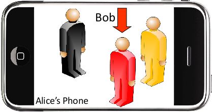
Escort Server
                               Escort Service
                               Mobile Cloud
 Escort Client

                                                                  Routing
                   Sensors                            Walking Trails
                                                                                  B
                 Computing          C
                 Radio

                                                     TBC
 A                           TAB                                            TCD
                                                                      D
                                                                Beacon

Figure 2: (a) The overview of the Escort system: Users report accelerometer and compass readings as well as user
encounters; The server forms user trails. (b) The graph theoretic representation of the server’s global view of the users’
trails and intersections.

  The rest of the paper is organized as follows. Section 2                            global view of user movements and spatial intersections. This
presents a high level system overview, followed by the chal-                          global view translates to a graph of paths between users. The
lenges and solutions in Section 3. The system evaluation is                           graph vertices are spatial intersections of user paths, while
presented in Section 4, while limitations and future work are                         the edges are walked trails between these intersections. Fig-
discussed in Section 5. Section 6 surveys the related work,                           ure 2(b) shows this translation for the scenario in Figure 2(a).
and the paper concludes with a brief summary in Section 7.
                                                                                         Practical challenges arise over time because the graph grows
2.               SYSTEM OVERVIEW                                                      large. Pruning heuristics are applied so that routing paths can
                                                                                      be computed efficiently. An assumption is made that a user’s
  Figure 2 shows the envisioned client/server architecture for
                                                                                      trail is bidirectional, i.e., if the user has walked from north to
Escort. We briefly describe the system components, followed
                                                                                      south, then it is possible for some other user to walk in the re-
by a discussion on challenges and solutions.
                                                                                      verse direction (south to north) along that same path. While
                                                                                      this may not be true for one-way street traffic, we believe this
   The Escort client periodically measures the accelerometer
                                                                                      holds for most walking applications.
and compass readings from user-carried mobile phones. Since
human walking patterns generate identifiable accelerometer
                                                                                        Thus, when Alice requests to meet Bob, the Escort-computed
signatures, the Escort client can compute the number of steps
                                                                                      route to Bob is returned as a sequence of displacement and
walked by the user. When multiplied by the user’s step size
                                                                                      angle tuples, i.e., < stepi , θi >. The Escort client can display
[8, 13, 34], we obtain the user’s approximate displacement.
                                                                                      a compass angle, θi , on the phone’s display, and as the user
The compass readings offer the direction of movement, and
                                                                                      takes the ith step, the following θi+1 can be shown. Continu-
when viewed in time-sequence, the  tuples capture the user’s movement pattern. We call
                                                                                      to Bob’s vicinity, achieving the goal of an electronic escort.
this a user’s walking trail.

  The user trail is periodically reported to the Escort server                        3.    CHALLENGES AND SYSTEM DESIGN
over a WiFi/3G connection. Due to sensor noise, the walk-                               The design of Escort in real environments presents practi-
ing trail drifts from the actual user movement. However, two                          cal challenges. This section characterizes the nature of these
opportunities are exploited to compensate for the drift: (i) en-                      challenges and presents our approaches in addressing them.
counters with the beacon, and (ii) encounters with users who
passed the beacon recently. Both these events, if detected,                           3.1    Noisy sensors
provide a better estimate of the user’s location. The differ-
ence between the new/better estimate and the old sensor-
computed estimate presents information about the nature of                            Accelerometer
the drift with compass and accelerometer. Escort uses this                            To determine a user’s walking trail, her displacement needs
drift information to correct the user trail and thus calculate                        to be computed from accelerometer measurements (Figure
more accurate routes between users.                                                   3(a)). One possible solution is to double-integrate the accel-
                                                                                      eration readings. Figure 3(b) shows the unacceptable results
   To detect encounters, the user device periodically signals                         from two test users who were asked to walk along straight
its presence while also listening for other devices. Signaling                        lines. The phones were held in the users’ hands. Evident
happens via audio, and consists of playing a specific tone at                         from the results, the error (the difference between the esti-
(almost) inaudible frequencies. This tone is assigned to the                          mated and actual displacement) increases sharply, reaching
user’s phone at registration with the Escort service. When de-                        more than 100m only after 30m of actual displacement. This
vice A learns about its encounter with device B, device A logs                        is an attribute of a noisy accelerometer, as well as jerky move-
this intersection and uploads it to the Escort server together                        ments of the phone while carried by the user.
with her trail. The server corrects for trail drifts and builds a
Accelerometer reading
70 Noise Histogram
0.04
Fitted Normal Distribution
60
0.03
50
PDF
40 Acc. reading 0.02
Step count
30 0.01
270 271 272 273 274 275 276 277 278 279
Time (s)
0
1000 −10 0 10 20 30 40
Noise Bin
Error (m)
Direct Acceleration Integral Figure 4: Compass noise distribution
500
0
0 5 10 15 20 25 30 35 40 45 50 55 more significantly than due to random oscillations. The turn
Distance (m) identification algorithm uses the following condition:
2
Error (m)
Step Count StdDev(ti ) + StdDev(ti+1 )
1 Avg(ti+1 ) − Avg(ti ) ≥ +G
2
0 where Avg(ti ) denotes the average compass readings over a
0 5 10 15 20 25 30 35 40 45 50 55
ti time period (e.g. 1 second), StdDev(ti ) is the standard de-
Distance (m)
viation of compass readings during ti , and G, a guard factor.
While on a constant direction, we compensate the stabilized
Figure 3: (a) Accelerometer readings (smoothened) from compass reading with the average bias, and report the re-
a walking user. (b) Displacement error with double inte- sulting value as the direction of the user. During turns, we
gration for two users. (c) Error with step count method. consider the sequence of readings reported by the compass.
A better approach to compute displacement from accelerom- Compass bias and turn identification are only heuristic meth-
eters is described in [8,13]. The idea is to identify an acceler- ods to compensate for the various sources of noise. In reality,
ation signature in human walking patterns as in Figure 3(a). the user’s compass-corrected direction may still differ from
This signature arises from the natural up and down bounce the true direction due to an incorrect bias estimation. Errors
of the human body while walking, and can be used to count from accelerometer-computed distances exacerbate the esti-
the number of steps walked. The physical displacement can mation. Our initial attempts to track the user’s trail proved
then be computed by multiplying step count with the user’s impractical – despite step count and compass models, the es-
step size, a function of the user’s weight and height [34]. We timated location and trail diverged in time from the true lo-
will use this approach, but unlike the work in [8], we vary cation and trail of the user. In order to correct these errors,
the step size with a error factor drawn from a Gaussian dis- we exploit opportunistic encounters, either with peers or with
tribution centered on 0 and standard deviation 0.15m. This the fixed beacon located in that area.
better accommodates the varying human step size. Figure
3(c) shows the far less accumulated error with the step count 3.2 Correcting User Position via Diffusion
method for the same 2 test users. The step count accuracy (as As mentioned earlier, the noise in the accelerometer and
verified across ten other users) is 96% on average. compass sensors cause the user position to diverge from her
actual location. To correct for this, we exploit a fixed beacon,
Compass which, if in range, can be detected by Escort users. When this
The compass noise is caused by several factors, including user happens, the user is repositioned at the beacon. The beacon
sway, movement irregularities, magnetic fields in the surround- position is considered to be at the origin of a virtual reference
ings, and the sensor’s internal bias. Since these sources are frame. Locations of users are computed with the beacon at
related to the user, her surroundings, and the sensor itself, (0, 0) and the X and Y axis as absolute north-south and east-
the noise is difficult to predict and compensate. For example, west directions, respectively. A user trail in the Escort virtual
we have experienced both changing compass biases and large reference frame is represented in Figure 5.
random oscillations even while a user walked multiple times
on the same path. Escort users are also repositioned when encountering other
users, say Eve, who have passed the fixed beacon in the re-
To characterize the compass noise we ran 100 experiments cent past (e.g., less than 1 minute ago). Thus, if Alice meets
using 2 Nokia 6210 Navigator phones and have observed an Eve, and Alice has not encountered the beacon within the last
average bias of 8o and a standard deviation of 9o degrees. N
Figure 4 shows the compass noise distribution. In addition to
this large noise range, we made two consistent observations:
(1) when the user is walking in a constant direction, the com- User Trail
pass readings stabilize quickly on a biased value and exhibit
only small random oscillations, and (2) after each turn, a new
bias is imposed. Based on these observations, we identify two
Beacon
states of the user: walking in a constant direction, and turn-
ing. Turns are identified when the compass headings change Figure 5: Escort’s virtual coordinate system with the bea-
con at the origin.−4
minute, then Alice is repositioned to Eve’s Escort-estimated x 10
8
position. Through this mechanism, fresh location information
can be “diffused” into the system. Put differently, the beacon
6
corrects the location of nearby users, who in turn correct the
Amplitude
locations of other encountered users. This resists the system
error from diverging. 4
In order to benefit from encounters, Escort needs to cap- 2
ture them accurately. An encounter may happen for only a
few seconds, therefore the detection mechanism has to be re-
0
liable. A number of existing works have used Bluetooth based 2.6 m to 5.2 m 7.8 m to 31.2 m Distance (m)
techniques for neighbor discovery [20,30]. Our attempts with
Bluetooth failed primarily because Bluetooth is too slow for Figure 7: Variation of tone amplitude with distance – two
detecting short-lived encounters. Our results showed that on classes of distances are marked.
average, 50% of the encounters remained undetected, deem-
ing this approach unusable. If future Bluetooth devices export
more overheard information to the device drivers, then Blue- tion in amplitude at 5m. We observed this reduction consis-
tooth can certainly be applicable. tently, and thereby thresholded it. Only if users overhear tone
amplitudes greater than this threshold (i.e., the transmitter is
We tackle the practical problem of detecting encounters by roughly within 5m), the encounter is registered. Reposition-
employing audio signals. The mobile phones and the bea- ing users based on such encounters will naturally incur this
con are instrumented to play a unique tone, while simulta- 5m error. Ideas from [24,25] may lower this error, and Escort
neously listening for tones from other phones. The tones are can certainly benefit from them.
on a specific narrow-band frequency; the selected frequen-
cies are almost outside the audible range in our implementa- As mentioned earlier, the fixed beacon is the origin of the
tion, and can be made inaudible for actual deployments. A virtual coordinate system. A relevant question is how do users
natural question is whether tone detection is reliable under join this coordinate system? When the Escort client starts, the
different noise scenarios. To verify this, we ran tone detec- user trail is initially computed in an isolated coordinate sys-
tion experiments in three locations: a student dormitory with tem that is only relative to the initial (unknown) location of
heavy AC noise, a meeting room with several people talking, the user. However, encounters with users who encountered
and a shopping mall with loud white noise. The phones were the fixed beacon, provide opportunities to bring this new user
placed close to each other, approximately 1m apart. Figure into the Escort’s coordinate system (with the beacon at the
6 shows that the tone frequencies (vertical dotted lines) are origin). Escort coalesces the position of a new user to that
clearly distinguishable from ambient sounds. of an encountered user who is already tracked by Escort. As
−3 a generalization, coordinate systems can be coalesced even if
x 10 none of the users have met the beacon. Later, when any one
5
Dormitory
of these users encounters the beacon, the entire coordinate
system gets updated with the beacon as the origin.
0
−3
x 10 3.3 Correcting User Trail (Drift Cancellation)
5
Amplitude
Correcting the instantaneous location of a user (as discussed
Meeting Room above), provides an opportunity to correct the user’s past trail
as well. Consider Figure 8. The solid black line depicts the
0 user’s true path, and the dotted line depicts the user’s com-
−3
x 10 puted trail (using accelerometer and compass). At the begin-
5
ning of this trail, at time tr1 , the user encounters the beacon
Shopping Mall and repositions herself. Since the estimated location right af-
ter the reposition is likely to be accurate, the starting point of
0
0 500 1000 1500 2000 2500 3000 3500 4000 this trail can be “nailed” with good accuracy. At some later
Frequency (Hz) time on this trail, another reposition operation happens at
time tr2 . At this time, we learn how much correction we need
Figure 6: Tone detection in three test scenarios: (a) stu- to apply to the estimated location at time tr2 to reposition
dent dormitory, (b) meeting room, and (c) shopping mall. the user. We mark this correction vector with V ~ , which is an
The red dotted line marks the tone frequency. estimation of the cumulative drift over time. Since the esti-
mated position after repositioning at tr1 (the starting point)
Detecting audio tones (transmitted by the fixed beacon or is accurate, the overall drift is accumulated only during time
other phones) is not sufficient. Escort needs to ensure that tr2 − tr1 . Based on this observation, we can correct the trail
the tone transmitter is nearby. otherwise, repositioning a user between two consecutive re-positionings. We call this method
to the tone transmitter’s position can introduce large errors. “Drift Cancellation”.
To this end, we investigated the possibility of computing the
transmitter-receiver distance from the tone amplitudes (Fig- The key idea of drift cancellation is to amortize the correc-
ure 7). Evidently, the amplitude does not exhibit a clear trend ~ over time. We assume that the user’s projected
tion vector V
with increasing distance; instead we observed a clear reduc- path deviates from the true path linearly over time. For ex-70 70 60
60 60
50 User 1
User 3
50
Y Coordinate (m)
Y Coordinate (m)
YCoordinate (m)
50
40 User 1
40 User 2
User 3
40
30 User 2 30
30
20 User 4
User 4
20
10 20
0 10 10
0 20 40 60 80 0 20 40 60 0 20 40 60
X Coordinate (m) X Coordinate (m) X Coordinate (m)
Figure 9: (a) The trail graph after tracking 4 users for 10 minutes. (b) The resulted graph after applying the pruning
heuristic. (c) Running Floyd-Warshall and the graph of user paths.
tr2 Without loss of generality, assume that Escort is running in
V
the steady state, i.e., all users have joined the Escort coor-
dinate system. To explain the pruning heuristic, let us con-
t t r1 sider two users A and B, and their respective Escort estimated
L' (t ) L(t ) V
L(t) t r 2 t r1 paths PA and PB (Figure 10). Let us say that PA and PB
intersect each other at several positions (I and J in Figure
L’(t) 10). Observe that the intersections are “spatial”, meaning that
tr1 the users may have crossed these locations at different points
in time. Consequently, the intersections are at different dis-
V = Correction vector
L(t) = User location at time t
tances with respect to each user – I is closer to user A, while
L’(t) = Corrected location at time t J is closer to B. Escort’s pruning heuristic selects the closest
(spatial) intersections for both A and B, and retains them as
vertices in the trail graph. Other intersections are eliminated.
Figure 8: Drift Cancellation: the solid line is the actual The two paths joining the two intersections are also retained
user path, the dotted line represents the user computed in this phase. This process is repeated for every pair of nodes
trail, and the dashed line denotes the user trail corrected in the system, resulting in a fully connected graph as shown
via Drift Cancellation. in Figure 9(b). This graph is then pruned again by apply-
ing the Floyd-Warshall algorithm and keeping the graph of
ample, if the time elapsed between two re-positionings was the shortest paths between users. The new smaller graph is
100 seconds, then, by this assumption, the correction vector shown in Figure 9(c). As users move, Escort will keep adding
~ . Mathematically, drift can-
at 50 seconds is exactly half of V edges and vertices to the trail graph, however, it will peri-
cellation can be described as follows. Let L(t) be the user odically re-apply the pruning heuristic. With the trail graph
estimated location at time t. Then for t ∈ (tr1 , tr2 ), we define pruning mechanism in place, Escort routing directions can be
the corrected location as: computed efficiently and presented to the requesting users.
~ t − tr1
L0 (t) = L(t) + V
tr2 − tr1
In Figure 8, the result of applying this correction to the
trail is represented as a dashed line. We expect this to better
approximate the true trail, shown in solid black.
3.4 Computing Routing Directions
Escort monitors user trails continuously. In the background,
the server computes the current position of each user, to- Figure 10: Spatial intersections between users.
gether with the spatial intersections of the users’ trails. Based
on this, Escort builds a “trail graph”. The graph edges are seg-
ments of user trails, while the vertices are either spatial inter- 3.5 Visual Identification
sections between trails or the current user locations. Figure Assume that Escort has routed Alice to within a few meters
2 showed the abstraction and Figure 9(a) shows a trail graph of Bob. If they are acquainted, Alice will easily identify Bob.
from our actual system. Since the number of vertices and Otherwise, Alice may be unable to identify him, especially if
edges grow over time, the trail graph quickly becomes dense multiple people are present around her. A possible solution
(Figure 9(a) is a result of 10 minutes of operation). Since is for Alice to acquire a picture of Bob, and attempt man-
maintaining such a graph (and routing over it) becomes inef- ual identification. However, such a picture may not be easily
ficient, Escort employs a graph pruning heuristic as described available. Even if an Internet search returns a few pictures,
next. Bob may not be facing Alice, making manual face recognition
a cumbersome task. To solve the human localization problem“end-to-end”, Escort should be able to pinpoint Bob, so Alice
knows exactly whom to approach. We propose the follow- Region selected
ing solution that users may optionally use in certain mutually by the user
trusted environments, such as a MobiCom conference.
For a given event/venue, each mobile phone will oppor- Fingerprint
tunistically take pictures of its owner. The phone may be able Upper subregion
to infer when the user is facing the device by leveraging the
second camera on the front of the phone (iPhone 4 already
has a front-facing camera to support video conferencing). The Lower subregion
pictures need not be of high quality – they may be partial, ori-
ented incorrectly, or include parts of other people and objects.
However, out of a multitude of pictures, the characteristics
of the user’s appearance, such as clothing color and texture,
can be summarized into a “fingerprint”. If the tuple is periodically beaconed, other mobile de- Figure 12: Generating the user fingerprint.
vices can utilize them to pinpoint the individual.
In an ideal setting, where Alice wants to identify Bob, the this, the cropped region is divided into an upper and lower
system would require her to turn on the camera and look subregion, corresponding to the upper and lower parts of
at the surrounding people through the phone’s viewfinder. the person’s body. This process is illustrated in Figure 12.
Recorded images will be analyzed and each individual in the Next, the pixels in each subregion are transformed into the
picture isolated through image processing (edge detection and hue-saturation-value (HSV) space (instead of RGB) to bet-
segmentation algorithms). The fingerprint of the isolated in- ter cope with lighting variations, shadows, etc. Then, three-
dividuals can be computed (denoted as test fingerprints) and dimensional Gaussian distributions [5] are fitted to the up-
compared against the beaconed fingerprint from Bob. The per and lower subregions using maximum likelihood estima-
test fingerprint that best matches Bob’s can be pinpointed on tion (MLE). The parameters (mean and variance) of the up-
the phone’s viewfinder. Figure 11 illustrates the idea – Bob per and lower Gaussians form the fingerprint of the person’s
is pinpointed with an arrow. We envision this to happen in image. Bob’s phone computes this fingerprint from Bob’s pic-
real time, perhaps by engaging cloud services for the CPU- tures and beacons it along with his name. Alice’s phones com-
intensive image processing algorithms [10]. In this paper, putes these fingerprints for all the people in her surroundings
however, we have addressed the problem offline, using some – we refer to these as “test fingerprints”.
degree of user participation. The methods are described next.
(3) Matching requires comparing the test fingerprints to
Bob’s fingerprint (since Alice is near Bob, her phone should
have overheard his beacons). We employ the following fin-
gerprint matching heuristic. For each test fingerprint, we
compute the similarity values Sup and Slow of the upper and
lower Gaussians. We measure the similarity of two Gaussians
as the volume of their intersection:
Z
Si = min(f (X|µtest_i , σtest_i ), f (X|µrecv_i , σrecv_i )) dX
Figure 11: Camera-based user identification.
where i = up, low and µtest_i , µrecv_i and σtest_i , σrecv_i
Visual identification entails three main challenges: (1) seg- are the mean and variance of the Gaussians in the test and re-
mentation: automatically cropping out the human boundaries ceived fingerprints, and f (X|µ, σ) is the density of the normal
in an image, (2) fingerprinting: creating a feature set of col- distribution at point X. Then, we rank all test fingerprints
ors for a cropped segment, and (3) matching: an algorithm to based on the product of the two similarity values Sup ∗ Slow ,
compute the similarity of two fingerprints. and declare the top-ranked fingerprint to be the “best” match.
Finally, we return to the corresponding region of the image,
(1) Segmenting images based on human contours is a well- and display "Bob" with an arrow. The effect is as in Figure 11.
studied problem in computer vision [11, 31]. These solutions
may be applied in our case too. However, instead of auto-
mated segmentation, we simplify the problem by asking Alice 3.6 Running Escort in the Cloud
to select all regions on the viewfinder where some person is Escort relies on users to periodically upload their compass,
located. Assuming multi-touch input technology, this trans- accelerometer and sound recordings. The service can be im-
lates to swiping the finger on different parts of the screen. plemented in a computing cloud. In such a context, the com-
The swiped regions are cropped out and processed to build putational cost for routing is not a concern. Similarly, FFT
the fingerprints of these people. transforms of sound recordings and image color processing
can be computed quickly. In our tests, we instantiated the Es-
(2) Fingerprinting translates to extracting a set of (color) cort service on an off-the shelf laptop and monitored 4 users.
features that will discriminate that person from others. For Under this small load we experienced no performance issues.4. EVALUATION
4.1 Testbed
To evaluate Escort, we need the accurate location of each
user (the ground truth). Otherwise, we cannot quantify both
the errors of the Escort-computed positions and the final dis- 39 m
tance between an escorted person and her destination (e.g.,
Alice and Bob). Since the system targets meter-scale accu-
racy, the real position of the user should be estimated within
a meter. The first solution we considered was to track users
through GPS. However, our experiments showed consistent
errors of 10m, making GPS impractical for our requirements.
In response, our solution was to run experiments in an area 55 m
containing markers with known positions. In this scenario,
Figure 14: Indoor Grid. Black color crosses indicate the
users move between markers and manually record each marker
positions of the markers. The solid black lines show paths
they pass, providing us with the ground truth.
walked by two of our test users. The beacon is placed at
the center of the building.
Deploying a grid of markers is challenging because of two
constraints: (i) we require a dense deployment of markers,
with small distances between them, so that we can track the same solution as employed in the parking lot – we deployed
user at a fine granularity (ii) we need accurate marker posi- 7 markers inside the building and determined their GPS posi-
tions to evaluate Escort’s instantaneous error and final-distance tions using Google Satellite View. The position of the markers
error after routing to a destination. and the beacon are shown in Figure 14, along with one of the
walked paths.
We have found a convenient way to fulfill these require-
ments using a university parking lot. We placed markers at 4.2 Methodology
the intersections and end-points of the white lines delimiting In order to test the system across a range of users, move-
the parking spots. Since the parking lot has several paral- ments, and encounter patterns, we split the evaluation exper-
lel lines, the number of markers we obtained was large, with iments in two stages. We call these stages: data collection and
an average distance between adjacent markers of around 5m. user routing. In the data collection stage a group of N users
The markers’ positions are obtained through their GPS coor- register with the Escort service and are monitored for some
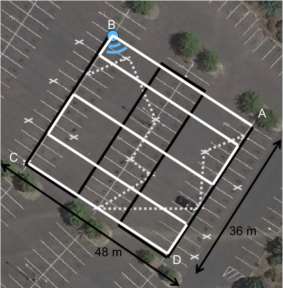
dinates from the Google Maps Satellite View. Figure 13 shows time T . The users move between markers in preset or ran-
the parking lot and some of the markers in white crosses. domly chosen paths. Each user has a “shadowing” person who
records the markers and the time these markers were crossed.
When the data collection phase ends at time T , we have the
movement and position history of each person. Note that the
markers’ GPS positions are translated into Escort’s coordinate
system. In this way, we obtain both the computed locations
and the actual positions of the user in the Escort coordinate
system. At any given time, the difference between these two
locations is Escort’s instantaneous error, and is a fine grained
indicator of Escort’s performance.
The efficacy of routing users is also of interest. For this, Es-
cort first computes the trail graph between all users at time t.
Then, it provides routing directions to A to navigate to B (we
assume that B is static at its known position at time t). The
routing directions are a sequence of displacement and angle
tuples, i.e., < stepi , θi >. Once A finishes following these
instructions, we measure the final distance between the real
positions of A and B.
Our parking lot experiment had N = 4 users (and 4 shadow
persons). Users carried the phones in hand, with the screen
facing up. The data collection phase was T = 13 minutes
Figure 13: Parking Lot Grid. White crosses indicate the long, and we executed 40 routing experiments in total. For
position of some of the markers in our experiments. The the indoor experiment, we used N = 2 users, a data collection
solid white and black lines show the fixed trails walked by phase of T = 6 minutes, and we ran 10 routing experiments.
two of our test users. The dashed line represents part of
a random user’s trail. The beacon is placed at position B. 4.3 Results
Our evaluation results concentrate on two metrics of the
We also ran experiments indoors, in one floor of our de- system: (1) the variation of instantaneous location error as
partment building. To obtain a ground truth, we applied the a function of time, and (2) the error at the end of a rout-60 1
Inertial
50 Beacon and Encounter
Drift Cancellation
0.8
40
Error (m)
0.6
CDF
30
0.4
20
Drift Cancellation
0.2 Beacon and Encounter
10 Inertial
0 0
0 100 200 300 400 500 600 700 0 10 20 30 40 50 60 70
Time (S) Instantaneous error (m)
Figure 15: User 2 instantaneous error with time Figure 17: CDF of the instantaneous error in parking lot.
50 1
Inertial 0.9
Beacon and Encounter
40 Drift Cancellation 0.8
0.7
Ave. Error (m)
30
0.6
CDF
0.5
0.4
20
0.3
0.2
10
0.1
0
0 0 5 10 15 20
1 2 3 4 Distance between user A and B at the end of escorting
User
Figure 16: Average instantaneous error per user. Figure 18: CDF of the final-distance error after routing in
the parking lot.
ing stage, i.e., the final-distance between the escorted person
and her destination. We present results from the parking lot ter escorting is completed. The average value recorded across
experiment first, followed by the indoor environment. There- all experiments was 8.2m. Figure 18 shows the distribution
after, we report the accuracy of visual identification (through of the final-distance.
the phone’s viewfinder).
We qualitatively show the Escort route between two ran-
Parking Lot Experiment dom users A and B. Figure 19 shows three examples of routing
Figure 15 shows how a user’s instantaneous error evolves trails. The shapes of these trails partly outline the patterns of
with time for three different schemes: (1) Inertial, (2) Bea- user movement. In an indoor environment, these shapes may
con and Encounters, and (3) Drift Cancellation. The Inertial mimic the floor plan of the building.
scheme shows how error grows if only the compass and ac-
celerometer sensors are used for localization. Evident from Indoor Experiment
the graph, the error grows quickly due to the inertial drift of The instantaneous location error is lower in the indoor envi-
these sensors. The Beacon and Encounters scheme has better ronment than in the parking lot. This is caused by the shape of
performance, as the instantaneous error drops every time a the building which confines the user movements to corridors
beacon is observed or an encounter happens, resulting in user and rooms (as opposed to any random path in the parking
repositioning. Drift Cancellation further reduces the error by lot). Drift cancellation adds to the benefits, achieving around
correcting users’ traces based on the drift vector estimated at 7m accuracy in 80% of the cases.
the time of repositioning.
Table 1 summarizes the final distance between the escorted
Figure 16 shows the average instantaneous error of the person and her destination. The final-distance is low in gen-
three schemes for each user. The average results across all eral with an average of 4.03m. In some of these traces, how-
users are 36.2m, 8.5m and 6.08m for the Inertial, Beacon ever, the turning points were slightly over or underestimated
and Encounters, and Drift Cancellation schemes, respectively. due to some residual noise in the trails. Nevertheless, even
The average errors are computed across the entire experiment with these small navigation inconsistencies, humans were able
length. To understand the distribution of instantaneous error, to guess what Escort is trying to convey; when Escort re-
we plot the CDF in Figure 17. As shown, the instantaneous quested the user to turn few meters ahead of an actual cor-
error is less than 10m in 68% of the cases. After drift cancel- ridor turn, the human ended up taking the correct turn. We
lation, 84% of the cases exhibit less than 10m error. believe that offering a visual representation of the entire path
will facilitate such forms of fault-tolerance (somewhat similar
Next, we evaluate the accuracy of escorting a user A to B. to in-car GPS systems).
The metric of interest is the final-distance between A and B af-60 10
50 50
Y Coordinate (m)
50
40 40 9
40
30 30
30 8
20 20 20 7
10 10 10 6
Error (m)
20 30 40 50 60 10 20 30 40 50 60 0 20 40 60
X Coordinate (m) X Coordinate (m) X Coordinate (m)
5
Figure 19: Routing trails between users.
4
1 3
2
0.8
Beacon and Encounter 1
Drift Cancellation
0.6 0
CDF
R1 R2 R3 R4 R5 R6 R7 R8 R9 R10
Beacon position
0.4
Figure 21: Average instantaneous error across all users
0.2
with random placements of the beacon.
0 100
0 5 10 15 20
Instantaneous error 90
Figure 20: CDF of the instantaneous error in the indoor 80
environment.
70
Accuracy, %
60
Routing experiments 3 and 6 in Table 1 show examples of
corner cases. In experiment 3 we have a final-distance of 12m, 50
primarily because the instantaneous error was large. Thus, 40
even if the routing directions were correct, the user ended
30
several meters short from her destination. In experiment 6,
the user could not be routed at all. A large compass bias 20
made the destination user appear as walking through walls, 10
and hence, Escort asked the seeking user to also turn into
0
the wall. Since no turns were in close range, the user could 1 2 3 4 5 6 7 8
not be routed. However, in a following experiment, at a later Number of users
time, the user could be routed successfully to her destination.
This happens when Escort finds another route, or when an- Figure 22: Accuracy of visual identification using the
other person walking through the same path, provides better phone camera.
movement trails.
fication task increases with the number of people. Neverthe-
Test 1 2 3 4 5 6 7 8 9 10
less, even with 8 people in the surroundings, our accuracy is
Err 5.2 3.2 12 0.8 3.7 X 5.2 1.5 3.7 1 close to 80%. These results, combined with navigation accu-
racy to within 8.2m of the destination, is expected to offer an
Table 1: Final-distance error in meters after routing in- end-to-end solution to human localization.
doors. X denotes user could not be routed.
We modeled the user movements and encounters from the 5. LIMITATIONS AND FUTURE WORK
users’ movement traces, and used it to simulate Escort. The Energy. Escort is not designed for energy efficiency – the
simulation mimics a scaled version of the parking lot exper- accelerometer, compass, and acoustic signaling will certainly
iment. Figure 21 shows the variation of instantaneous error consume battery power. Nevertheless, there are various op-
(averaged over time and 4 users) for random placements of portunities for system optimization. When users are not mov-
the fixed beacon. Evidently, the error remains quite stable, ing, Escort can, for example, turn off all the sensors except
demonstrating that Escort’s performance is not too sensitive the accelerometer (which has a reasonably low power con-
to the beacon placement. Of course, the routing performance sumption). Once the user moves again (detectable by the
could not be evaluated in the simulator because it needs a accelerometer), all other sensors can be turned back on. With
human being to follow the Escort instructions. many users in a place, each user can considerably reduce the
periodicity of audio signaling; in fact placing more fixed bea-
People Identification Accuracy cons further facilitates this opportunity. Also, frequent up-
We evaluated the accuracy of identifying people through the loading of sensor data to the Escort server is not required un-
camera viewfinder using pictures from social events. We used less someone is being escorted to this user. An energy-efficient
these pictures to simulate different configurations of test and version of Escort is left for future research.
beaconed fingerprints. Figure 22 shows the average identi-
fication accuracy as a function of the number of beaconed Routing through physical obstacles. Escort may give di-
fingerprints in the surroundings. The difficulty of the identi- rections to turn through obstacles or walls. However, if Escortdirections reflect a good approximation of the route, humans Unlike these systems, Escort requires minimal hardware sup-
can make educated decisions about which path to follow. For port: compass and accelerometer sensors in off-the-shelf mo-
example asking to take a turn before a hallway, may not be bile phones, and a beacon, e.g., an audio device.
an issue, if the user is within a small distance of the turn. In
addition, visual representations of the escorted path may help Radar [3], Active Campus [15] and PlaceLab [6] rely on
in guiding the user’s decisions. access points already present in the surroundings to enable
localization. These solutions require calibrating WiFi signal
Long Routing Paths. Escort may route Alice on a longer strengths at many physical locations. The calibration pro-
path even though Bob may be close by. This happens when cess is time-consuming and may not scale over large areas.
Escort is not aware of a possible trail along the shortest path Unlike these systems, Escort does not require war-driving or
(see Figure 19(b)). However, this may be indicative of a signal calibration. Our approach is straightforward: we rely
blockage on that path. As an optimization, Escort can pro- on trails and encounters to achieve localization and provide
vide a straight line route between users, since it knows their routing directions between users.
positions. Then, the escorted user may either follow the di-
rect path or the Escort computed one. We plan to investigate Another line of research uses floor plans and maps to as-
the problem of “best” routing paths as part of our future work. sist in user localization. Authors in [13] rely on a floor plan
coupled with WiFi war-driving and inertial sensors to enable
Routing Instructions under Low Location Accuracy. Rout- localization. CompAcc [8] is an outdoor localization scheme
ing a user when her position is not accurate may cause Escort which builds a user trail similar to Escort. However, Com-
to give poor navigation instructions. Nevertheless, Escort has pAcc provides localization by using a combination of GPS and
knowledge of the last time the user received fresh location paths retrieved from Google Maps. Escort does not require
information. If this encounter is too far in the past, the sys- GPS, war-driving, maps or floor plans. Escort builds its own
tem may instruct the user to walk in a direction in which she coordinate system in which it estimates the user location and
can find fresh location information (e.g., ask the user to move her trails.
towards the direction of a crowd). Once better position infor-
mation becomes available, Escort may recompute the route Finally, related work in robotics investigated the problem of
directions and give the user a better path to her destination. simultaneous localization and mapping (SLAM). In this line
of research a robot builds a map of the surroundings and lo-
Phone Placement. Our assumption of carrying phones in calize itself using this map. The key insight behind SLAM
hand may be optimistic. In general, inferring the orienta- is to identify a number of landmarks and use them as refer-
tion of the phone is non-trivial. Nevertheless, Nericell [21] ence points. Thus, SLAM translates into solving two distinct
showed how to infer the position of the phone relative to a problems [32]: (i) identify the landmarks and (ii) approxi-
reference frame (a car driving on the road) using the phone mate the range and bearing to/from these landmarks. Real
accelerometer. A recent project titled “Which Way Am I Fac- life deployments solve the two problems jointly, using range
ing?” [18] achieved good results in deriving the compass ori- sensors, such as lasers [22] or radar [12]. Note that our
entation from a randomly-oriented wearable device. We be- system relies solely on sensors available in mobile phones,
lieve these works, coupled with the arrival of gyroscopes in less accurate than radar or laser ranging. Further, landmark
mobile phones, will provide new opportunities to estimate the identification may be problematic for mobile phones. Unlike
phone orientation. We plan to address these issues in future SLAM, Escort does not build a map of landmarks. For our
work. purposes localization/escorting happens only along the paths
previously walked by the users.
Behavior under heavy user load. We think Escort accu-
racy will improve with a large number of users and increased
mobility. We argue that under such scenarios, Escort users
7. CONCLUSIONS
will have a higher chance to pass each other or encounter Recent years have seen multiple branches of research in lo-
the beacon. Similarly, placing the beacon in a popular place, calization technology. This paper identifies the problem of
or adding extra beacons, may provide additional opportuni- social localization, where the goal is to help a person, Alice,
ties to correct and diffuse location information. Nevertheless, navigate to another person, Bob. Our key observation is that
since Escort is an early attempt in human localization, we knowledge of users’ absolute locations are not necessary. In-
plan to investigate scalability issues as part of future work. stead, we show that by recording users’ movement patterns
(via phone compasses and accelerometers) and mutual en-
counters (via audio signaling), a graph can be created on a
6. RELATED WORK common coordinate system. Using such a graph, a human
Previous research considered user localization, but did not can be routed to any other human. We use these intuitions to
address the challenges of providing directions to localize peo- develop Escort, and demonstrate the feasibility of escorting
ple. Even if accurate user location is available, challenges a user to within 8m of her destination. We believe a mature
remain in navigating a user to a destination. Escort is a pro- version of such a technology can enable a new class of social
totype addressing this issue. proximity based applications.
Previous localization solutions considered deploying radios
or specialized hardware in the environment to assist localiza- 8. ACKNOWLEDGEMENTS
tion. The user position is estimated based on the overheard We sincerely thank our shepherd Srdjan Capkun and the
signals and the data collected during a calibration phase. Cricket anonymous reviewers for their invaluable feedback which helped
[26], VOR [23] and Pinpoint [35] rely on these techniques. improve this paper. We also thank Justin Manweiler, NaveenSanthapuri, Souvik Sen, Sandip Agrawal, Joe Levy, Ga-Young [17] J. Krumm and K. Hinckley. The nearme wireless
Joung, Trevor Narayan and Bogdan Romanescu for the nu- proximity server. In Ubicomp, 2004.
merous discussions and their help during the research and [18] K. Kunze, P. Lukowicz, K. Partridge, and B. Begole.
evaluation phases of Escort. We are also grateful to Nokia Which way am i facing: Inferring horizontal device
and NSF for partially funding this research through grants orientation from an accelerometer signal. In IEEE
CNS-0916997 and CNS-0910846. International Symposium on Wearable Computers, 2009.
[19] K. Lin, A. Kansal, D. Lymberopoulos, and F. Zhao.
9. REFERENCES Energy-accuracy trade-off for continuous mobile device
[1] G. Ananthanarayanan, M. Haridasan, I. Mohomed, location. In ACM MobiSys, 2010.
D. Terry, and C. A. Thekkath. Startrack: a framework [20] L. McNamara, C. Mascolo, and L. Capra. Media sharing
for enabling track-based applications. In ACM MobiSys, based on colocation prediction in urban transport. In
2009. ACM MobiCom, 2008.
[2] M. Azizyan, I. Constandache, and R. R. Choudhury. [21] P. Mohan, V. Padmanabhan, and R. Ramjee. Nericell:
Surroundsense: Localizing mobile phones via ambience Rich monitoring of road and traffic conditions using
fingerprinting. In ACM MobiCom, 2009. mobile smartphones. In ACM SenSys, 2008.
[3] P. Bahl and V. N. Padmanabhan. Radar: an in-building [22] M. Montemerlo, S. Thrun, D. Koller, and B. Wegbreit.
rf-based user location and tracking system. In IEEE FastSLAM: A factored solution to the simultaneous
Infocom, 2000. localization and mapping problem. In Proceedings of the
[4] N. Banerjee, S. Agarwal, P. Bahl, R. Chandra, National Conference on Artificial Intelligence, 2002.
A. Wolman, and M. Corner. Virtual compass: relative [23] D. Niculescu and B. Nath. VOR base stations for indoor
positioning to sense mobile social interactions. In 802.11 positioning. In ACM MobiCom, 2004.
Pervasive, 2010. [24] C. Peng, G. Shen, Y. Zhang, Y. Li, and K. Tan. Beepbeep:
[5] C. Bishop. Pattern recognition and machine learning. a high accuracy acoustic ranging system using cots
Springer, 2006. mobile devices. In ACM SenSys, 2007.
[6] Y. Chen, Y. Chawathe, A. LaMarca, and J. Krumm. [25] C. Peng, G. Shen, Y. Zhang, and S. Lu. Point & connect:
Accuracy characterization for metropolitan-scale wi-fi intention-based device pairing for mobile phone users.
localization. In ACM MobiSys, 2005. In ACM MobiSys, 2009.
[7] Y.-C. Cheng, Y. Chawathe, A. LaMarca, and J. Krumm. [26] N. B. Priyantha, A. Chakraborty, and H. Balakrishnan.
Accuracy characterization for metropolitan-scale wi-fi The cricket location-support system. In ACM MobiCom,
localization. In ACM MobiSys, 2005. 2000.
[8] I. Constandache, R. R. Choudhury, and I. Rhee. [27] M.-R. Ra, J. Paek, A. B. Sharma, R. Govindan, M. H.
Towards mobile phone localization without Krieger, and M. J. Neely. Energy-delay tradeoffs in
war-driving. In IEEE Infocom, 2010. smartphone applications. In ACM MobiSys, 2010.
[9] I. Constandache, S. Gaonkar, M. Sayler, R. R. [28] N. Ravi and L. Iftode. Fiatlux: Fingerprinting rooms
Choudhury, and L. Cox. EnLoc: Energy-efficient using light intensity. In Pervasive, 2007.
localization for mobile phones. In IEEE Infocom Mini [29] N. Ravi, P. Shankar, A. Frankel, A. Elgammal, and
Conference, 2009. L. Iftode. Indoor localization using camera phones. In
[10] E. Cuervo, A. Balasubramanian, D.-k. Cho, A. Wolman, IEEE Workshop on Mobile Computing Systems and
S. Saroiu, R. Chandra, and P. Bahl. Maui: making Applications, 2006.
smartphones last longer with code offload. In ACM [30] T. J. Smith, S. Saroiu, and A. Wolman. Bluemonarch: a
MobiSys, 2010. system for evaluating bluetooth applications in the
[11] N. Dalal and B. Triggs. Histograms of oriented wild. In ACM MobiSys, 2009.
gradients for human detection. In CVPR, 2005. [31] K. Tabb, N. Davey, S. George, and R. Adams. Detecting
[12] M. Dissanayake, P. Newman, S. Clark, partial occlusion of humans using snakes and neural
H. Durrant-Whyte, and M. Csorba. A solution to the networks. In Conference on Engineering App. of Neural
simultaneous localization and map building (SLAM) Networks, 1999.
problem. IEEE Trans. on Robotics and Automation, 2001. [32] S. Thrun and J. J. Leonard. Handbook of Robotics,
[13] F. Evennou and F. Marx. Advanced integration of wifi Chapter 37, Simultaneous Localization and Mapping.
and inertial navigation systems for indoor mobile Springer, 2008.
positioning. EURASIP J. Appl. Signal Process., 2006. [33] Y. Wang, J. Lin, M. Annavaram, Q. A. Jacobson,
[14] S. Gaonkar, J. Li, R. R. Choudhury, L. Cox, and J. Hong, B. Krishnamachari, and N. Sadeh. A
A. Schmidt. Micro-blog: Sharing and querying content framework of energy efficient mobile sensing for
through mobile phones and social participation. In automatic user state recognition. In ACM MobiSys,
ACM MobiSys, 2008. 2009.
[15] W. G. Griswold, P. Shanahan, S. W. Brown, R. Boyer, [34] Step size in pedometers. http://walking.about.com/cs
and M. Ratto. Activecampus - experiments in /pedometers/a/pedometerset.htm.
community-oriented ubiquitous computing. IEEE [35] M. Youssef, A. Youssef, C. Reiger, A. Shankar, and
Computer, 2003. A. Agrawala. Pinpoint: An asynchronous time-based
[16] M. B. Kjærgaard, J. Langdal, T. Godsk, and T. Toftkjær. location determination system. In ACM MobiSys, 2006.
Entracked: energy-efficient robust position tracking for [36] Z. Zhuang, K.-H. Kim, and J. P. Singh. Improving
mobile devices. In ACM MobiSys, 2009. energy efficiency of location sensing on smartphones.
In ACM MobiSys, 2010.You can also read