Digital Commons @ Andrews University - Andrews University - Digital ...
←
→
Page content transcription
If your browser does not render page correctly, please read the page content below
Andrews University
Digital Commons @ Andrews University

Master's Theses                                                                           Graduate Research

2020

The Casemate Wall System of Khirbat Safra
Elizabeth Anne Emswiler
Andrews University, emswiler@andrews.edu

Follow this and additional works at: https://digitalcommons.andrews.edu/theses

   Part of the Ancient, Medieval, Renaissance and Baroque Art and Architecture Commons

Recommended Citation
Emswiler, Elizabeth Anne, "The Casemate Wall System of Khirbat Safra" (2020). Master's Theses. 156.
https://digitalcommons.andrews.edu/theses/156

This Thesis is brought to you for free and open access by the Graduate Research at Digital Commons @ Andrews
University. It has been accepted for inclusion in Master's Theses by an authorized administrator of Digital
Commons @ Andrews University. For more information, please contact repository@andrews.edu.
ABSTRACT

             THE CASEMATE WALL SYSTEM OF KHIRBAT SAFRA

                                  by

                        Elizabeth Anne Emswiler

Adviser: Paul J. Ray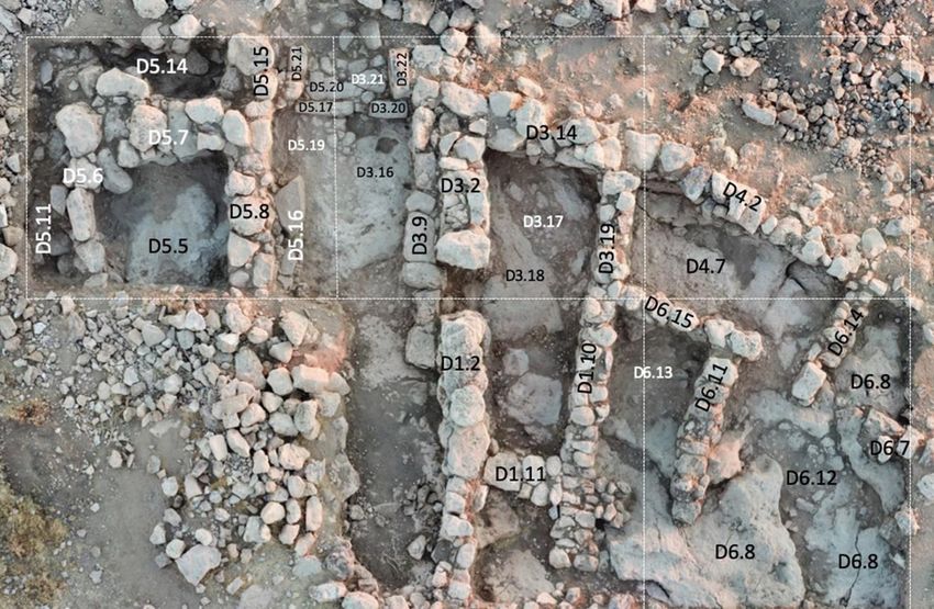
ABSTRACT OF GRADUATE STUDENT RESEARCH

                                         Thesis

                                  Andrews University

                      Seventh-day Adventist Theological Seminary

Title: THE CASEMATE WALL SYSTEM OF KHIRBAT SAFRA

Name of researcher: Elizabeth Emswiler

Name and degree of faculty advisor: Paul J. Ray, Ph.D.

Date completed:

                                         Problem

       A casemate wall system was found at Khirbat Safra in 2018 and 2019, which has

been dated to early Iron Age I. However, no comprehensive study of Iron Age I casemate

wall systems in Transjordan has been conducted. Therefore, this thesis will present and

compare the findings from Kh. Safra and four other sites in Transjordan which have

casemate wall systems dating to Iron Age I.

                                         Method

       A short study on the history of fortifications, casemate wall systems, and siege

warfare was conducted for this thesis. The ruins from Fields A, B, C, and D at Kh. Safra
were then examined along with the ruins of four other Iron Age I casemate wall systems

in Transjordan. Lastly, the features of these five casemate wall systems were compared.

                                          Results

       Parallels to the casemate wall system of Kh. Safra were found at four sites

throughout Transjordan. A comparison of the parallels helps to understand the form and

function of the Iron Age I casemate wall systems found in Transjordan so far.

                                       Conclusions

       It was possible to conclude that the casemate wall system of Kh. Safra is unique

in terms of its location (being the only Iron Age I casemate wall system in its region) but

not in terms of its form and function. Rather, Kh. Safra and the four other Iron Age I

casemate wall systems in Transjordan share many similarities both architecturally and

potentially through the purpose these defensive walls served.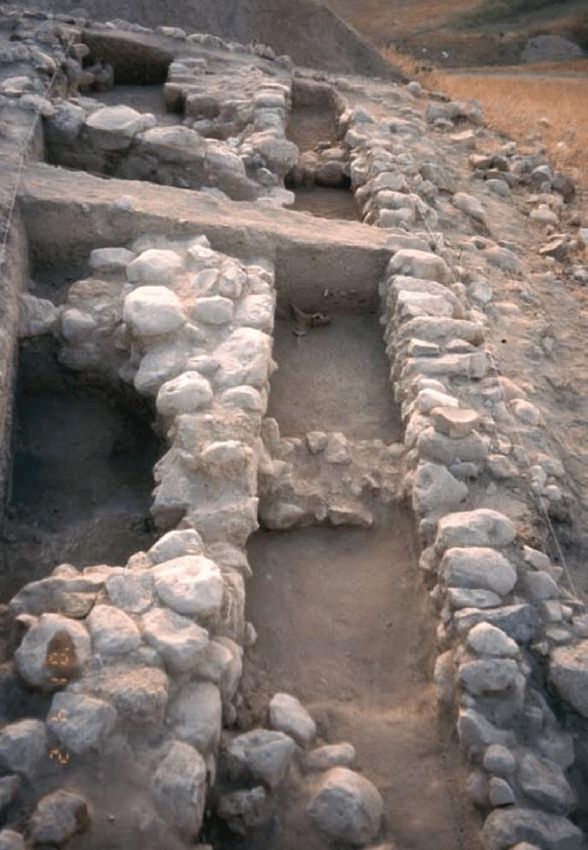
Andrews University

     Seventh-day Adventist Theological Seminary

THE CASEMATE WALL SYSTEM OF KHIRBAT SAFRA

                      A Thesis

           Presented in Partial Fulfillment

         of the Requirements for the Degree

                   Master of Arts

                         by

              Elizabeth Anne Emswiler

                        2020
© Copyright by Elizabeth Anne Emswiler 2020
            All Rights Reserved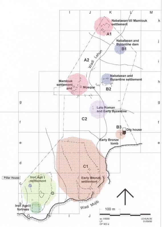
THE CASEMATE WALL SYSTEM OF KHIRBAT SAFRA

                                    A thesis
                        presented in partial fulfillment
                      of the requirements for the degree
                                Master of Arts

                                     by

                          Elizabeth Anne Emswiler

APPROVAL BY THE COMMITTEE:

__________________________________
Paul J. Ray, Ph.D., Chair

__________________________________            ______________________________
Paul Zeljko Gregor, Ph.D.                     Date approved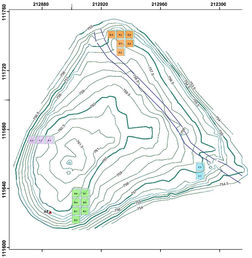
TABLE OF CONTENTS

LIST OF FIGURES .....................................................................................................      v

Chapter
   1. INTRODUCTION ...........................................................................................             1

     2. CASEMATE WALL SYSTEMS ....................................................................                         3

            Brief History of the Development of Fortifications ......................................                      3
            General Description of Casemate Wall Systems of the
                Ancient Near East ...................................................................................      4
            Origin and Early Examples of the Casemate Wall System ...........................                              5
            Casemate Wall Systems and Siege Warfare ..................................................                    10

     3. THE CASEMATE WALL SYSTEM OF KHIRBAT SAFRA .......................                                                 16

            Introduction to Khirbat Safra.........................................................................        16
            Casemate Wall System in Field A .................................................................             16
                 Field A Square 1 – Casemate Wall System............................................                      19
                 Field A Square 3 .....................................................................................   20
            Casemate Wall System in Field B .................................................................             21
                 Field B Squares 1 and 3 – Casemate Wall System ................................                          21
                 Field B Squares 1-6 – Buildings 1 and 2 ................................................                 24
            Casemate Wall System in Field C .................................................................             25
                 Field C Square 1 – Casemate Wall System ............................................                     27
                 Field C Square 1 and 2 – Rooms North of Casemate Wall System .......                                     28
            Casemate Wall System in Field D .................................................................             29
                 Field D Squares 3, 4, and 6 – Casemate Wall System ...........................                           30
                 Field D Squares 3 and 5 – City Gate Complex ......................................                       31
                 Field D Squares 1, 2, and 6 – Interior Buildings/Phasing ......................                          32
            Summary of Casemate Wall System .............................................................                 33
            Preliminary Conclusions ...............................................................................       33

     4. IRON AGE I CASEMATE WALL SYSTEMS IN TRANSJORDAN ...........                                                       35

            Khirbat al-Ma’mariyah ..................................................................................      35
            Khirbat al-Mudayna al-‘Aliya .......................................................................          46
                Casemate Wall System of Khirbat al-Mudayna al-‘Aliya......................                                50
                Ceramics of Khirbat al-Mudayna al-‘Aliya ...........................................                      57

                                                              iii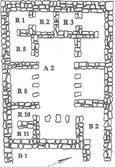
Khirbat al-Mudayna al-Mu’arrajah ...............................................................               61
                Casemate Wall System of Khirbat al-Mudayna al-Mu’arrajah ..............                                    61
                Ceramics of Khirbat al-Mudayna al-Mu’arrajah ....................................                          67
            Khirbat al-Lahun ...........................................................................................   70

     5. COMPARISON BETWEEN SIMILAR CASEMATE WALL
        STRUCTURES ................................................................................................        74

CONCLUSION ............................................................................................................    80

REFERENCE LIST .....................................................................................................       81

                                                              iv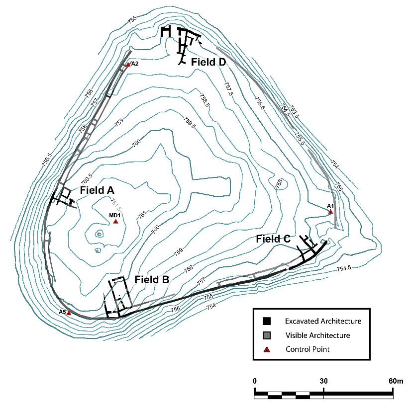
LIST OF FIGURES

1. Example of a Casemate Wall .................................................................................               5

2.    Caissons Wall at Alishar and Casemate-Like Wall at Boğazköy .........................                                   6

3.    Plan of MB IIC-LB I Casemate at Tell Ta’annek .................................................                         8

4.    Commercial Complex (Bakery) with City Wall and One Casemate Room from
        Stratum IIB (First Half of Late Bronze Age) at Abu al-Kharaz ......................                                   8

5.   Stratum III in Area K at Hazor Showing Casemate Walls in Connection
     with the City Gate ..................................................................................................    9

6. Casemate Wall E, Part of Field IV at Shechem .....................................................                         9

7. Casemate Wall System in Area 1 at Zira’a ............................................................                     11

8. Casemate Wall System on North, West, and South Side of Iron I Settlement
   at Kh. al-Lahun ......................................................................................................    11

9. A Primitive Battering Ram Depicted on a Wall Painting from Beni-Hasan .........                                           12

10. Assyrian Siege Engine Attacking Lachish .............................................................                    14

11. An Assyrian Attack on a City with a Battering Ram .............................................                          14

12. Location of Kh. Safra .............................................................................................      17

13. Topographic Map of Kh. Safra with Excavation Fields ........................................                             18

14. The Casemate Wall System of Kh. Safra...............................................................                     18

15. Kh. Safra Field A ...................................................................................................    19

16. Kh. Safra Field B ...................................................................................................    22

17. Kh. Safra Field B3 East Balk .................................................................................           24

18. Kh. Safra Field C ...................................................................................................    26

                                                                v
19. Kh. Safra Field C1 North Balk .............................................................................. 29
20. Kh. Safra Field D ................................................................................................... 30
21. Chart Representing Objects Found in 2018 and 2019 Seasons at Kh. Safra ......... 34
22. Map of Sites with Iron Age I Casemate Wall Systems in Transjordan ................. 36
23. Aerial of Kh. al-Ma’mariyah ................................................................................. 37
24. Region of the Wadi ash-Shkafiya Survey .............................................................. 38
25. Citadel at Kh. al-Ma’mariyah ................................................................................ 40
26. Kh. al-Ma’mariyah C1 ........................................................................................... 41
27. Kh. al-Ma’mariyah F1 ........................................................................................... 42
28. Kh. al-Ma’mariyah Area G .................................................................................... 42
29. Grinding Stones Found in Area G of Kh. al-Ma’mariyah ..................................... 43
30. Iron Age I Pottery Assemblage from Kh. al-Ma’mariyah, 1 ................................. 44
31. Iron Age I Pottery Assemblage from Kh. al-Ma’mariyah, 2 ................................. 45
32. Map of South-Central Jordan Showing Location of Kh. al-Mudayna al-‘Aliya ... 47
33. Aerial Image of Kh. al-Mudayna al-‘Aliya, Looking North .................................. 48
34. Top Plan of the Architecture and Topography at Kh. al-Mudayna al-‘Aliya ........ 49
35. Top Plan of Building 100 at Kh. al-Mudayna al-‘Aliya ........................................ 52
36. Top Plan of Building 300 at Kh. al-Mudayna al-‘Aliya ........................................ 53
37. Top Plan of Building 400 at Kh. al-Mudayna al-‘Aliya ........................................ 53
38. Top Plan of Building 800 at Kh. al-Mudayna al-‘Aliya ........................................ 54
39. Top Plan of Building 200 at Kh. al-Mudayna al-‘Aliya ........................................ 54
40. Top Plan of Building 500 at Kh. al-Mudayna al-‘Aliya ........................................ 55
41. Top Plan of Building 700 at Kh. al-Mudayna al-‘Aliya ........................................ 56
vi42. Top Plan of Building 600 at Kh. al-Mudayna al-‘Aliya ........................................ 56
43. Iron Age I Bowls from Kh. al-Mudayna al-‘Aliya ................................................ 58
44. Iron Age I Bowls, Kraters, and Cooking Jugs from Kh. al-Mudayna al-‘Aliya .... 59
45. Iron Age I Storage Jars, Jars, and Jugs from Kh. al-Mudayna al-‘Aliya ............... 60
46. Topography of Kh. al-Mudayna al-Mu’arrajah ..................................................... 62
47. Top Plan of Kh. al-Mudayna al-Mu’arrajah .......................................................... 63
48. City Gate and House at Kh. al-Mudayna al-Mu’arrajah ........................................ 64
49. Towers 1-3 at Kh. al-Mudayna al-Mu’arrajah ....................................................... 68
50. Iron Age I Pottery Assemblage from Kh. al-Mudayna al-Mu’arrajah................... 69
51. Site of Kh. al-Lahun ............................................................................................... 71
52. Top Plan of Iron Age Settlement and Fortress at Kh. al-Lahun ............................ 72
53. Comparison the Casemate Wall Systems Discussed in this Paper ........................ 75
54. Building 2, Field B, Kh. Safra ............................................................................... 77
55. Building 400 at Kh. al-Mudayna al-‘Aliya ............................................................ 78
viiCHAPTER 1
INTRODUCTION
Casemate wall systems are relatively common throughout the Southern Levant
beginning in the Middle Bronze Age and ending in Iron Age II. Recently, a casemate
wall system dating to Iron Age I was discovered at Khirbat Safra, a site at which
excavations began in the 2018 season. Under the direction of Paul Gregor, Constance
Gane, and Paul Ray of the Institute of Archaeology at Andrews University, four fields
were opened. Each field revealed part of a casemate wall system. Approximately 17 km
southwest of Madaba, this site appears to have had three occupational phases with the
earliest settlement (during Iron Age I) being the origin for most of the architecture
including the casemate wall system.
The present study starts with a short look at the history of fortifications, casemate
wall systems, and siege warfare. It summarizes the development of fortifications, the
origin of the casemate wall system, and looks at how developments in siege warfare
made the casemate style fall out of use. Following that, an examination of the casemate
wall system at Kh. Safra is presented. As excavation at Kh. Safra has just recently begun,
there are very few publications that have been written on this site. Only two preliminary
reports have been written which along with the field notebooks will be the primary
sources of information for the data in Chapter 2. Then, a survey was conducted of four
Iron Age I casemate wall systems in Transjordan (Khirbat al-Ma’mariyah, Khirbat al-
1Mudayna al-‘Aliya, Khirbat al-Mudayna al-Mu’arrajah, and Khirbat al-Lahun) with a
brief introduction to the site, a history of the excavations, and a presentation of the
available data regarding the fortifications. Finally, the casemate wall system at Kh. Safra
will be compared to those four casemate wall systems, specifically regarding their form
and function.
This thesis is a descriptive project and therefore does not bring any new data or
solutions and does not attempt to identify the site. Rather, the aim of this thesis is to
describe and investigate the casemate wall system of Kh. Safra and look for comparisons
with the other Iron Age I casemate wall systems in Transjordan.
2CHAPTER 2
CASEMATE WALL SYSTEMS
Brief History of the Development of Fortifications
Fortifications became prominent in the Southern Levant during the Early Bronze
Age (henceforth EB). Permanent settlements formed and people groups became attached
to a specific region often because of that region’s abundant resources. There was then a
need to defend their homes and belongings. Fortifications developed as a way to protect
the core of a settlement which often consisted of public buildings, homes, and stored
resources. The need for protection resulted from an increase in attacks by neighboring
settlements, nomads, and seminomads. The most common types of fortification elements
consisted of city walls, towers, gatehouses, glacis, ramparts, bastions, and fosses or
moats.
Throughout the EB, city walls developed from a single narrow wall in EBI (1.5 to
3.0 m thick) to a single thick wall in EBIII (8.0 to 10 m thick; Kempinski 1992a: 68).
Many city walls reverted to a narrower thickness during the Middle Bronze Age
(henceforth MB) often between 2.0 and 4.0 m thick (Kempinski 1992b: 127). It is in this
period where the regions earliest casemate wall systems are found (Lapp, N. 1976: 25).
Generally, no new city walls were built in the Late Bronze (henceforth LB). Most cities
either reused the preexisting MB walls or the settlement lacked fortifications all together
(Gonen 1984: 62). The Iron Age brings a wider range of settlement types from capital
3cities and administrative cities, to provincial towns and villages. The variety of settlement
types also brought in a variety of fortifications based on that settlement’s need and
available resources. For city walls this meant an increase in the usage of casemate walls
and the development of multiple sub-types of massive walls as well as the
implementation of a simple peripheral belt of houses (Herzog 1992: 270).
General Description of Casemate Wall Systems of
the Ancient Near East
Casemate wall systems, while most common during Iron Age II, appear as early
as the MB (Burke 2008: 59). Most fortification walls in the MB were built thicker in
order to withstand attacks, commonly called massive or solid walls and found in
Cyclopean or Hyksos style fortifications. However, building this type of fortification took
more time, manpower, and supplies. Casemate wall systems provided an alternative type
of fortification which were easier to build. These systems are comprised of two thinner,
parallel walls with a varying amount of space between them. Transverse walls were built
within these spaces which separated the area between the city walls into small rooms
(Figure 1). These rooms could then be used for storage and extra living space during
times of peace or they could easily be filled in with rocks and soil in order to create a
thicker fortification wall. While sometimes constructed around the entire settlement, most
casemate-style walls were used only for a part of the settlement’s defenses.
There are three main types of casemate wall systems found throughout the
Southern Levant. Freestanding casemate walls are where the inner casemate walls are
separated from the buildings within the settlement. In this case, the entrances to the
casemate rooms would often lead out to a road. Integrated casemate walls are when the
4Figure 1. Example of a casemate wall at Tall Abu al-Kharaz (from Fischer 2008: 202).
inner casemate wall is integrated into the buildings within the settlement. The third type
is known as a filled casemate wall. In this type of fortification, the rooms were never
meant to be used. Instead they were built in the casemate style and quickly filled with
soil. The filled casemate wall often occurred when the wall needed to be built to a greater
height but still quickly, as this building technique provided a more stable framework.
Origin and Early Examples of the Casemate Wall System
It had long been presumed that the construction of casemate wall systems began
in Asia Minor in the MB and LB and didn’t reach Cisjordan until Iron Age I, and then
only through Syrian mediation. Alexander Badawy, an Egyptologist, argued that the
5casemate wall derived from the caisson type construction which was perfected during the
second millennium B.C. He proposed that it “evolved rapidly from a row of contiguous
square walled-in compartments, like that of Alishar to a system of two thick parallel
walls bound with transverse partitions and having towers that projected at regular
intervals, which can be seen at Boğazköy” (Figure 2; Badawy 1966: 142). While these
rooms were generally not large enough to be used as living space there is evidence that
they were used “for storage or as blockhouses for firing” (Badawy 1966: 142).
Figure 2. Caissons wall at Alishar and casemate-like wall at Boğazköy (from Badawy
1966: 142).
6While discussing the origins of the casemate wall system, W.F. Albright wrote,
The casemate wall is an excellent example of a type which enjoyed great vogue in
Palestine in the eleventh and tenth centuries, and continued in sporadic use into
the latter part of Iron II. This type of wall originated in Late Bronze Asia Minor,
and was brough to Syria by the Hittites; from Syria it spread southward during the
transition from Bronze to Iron (Albright, 1960: 120-21).
Yigael Yadin, after discovering a casemate at Tel Megiddo in 1960, described the
origin of casemate wall systems as the following:
Casemate fortifications were introduced, as we have seen, in the Middle Bronze
period, and they were developed largely under the Hittite Empire in the Late
Bronze period…. The idea presumable travelled from here to Syria and Palestine,
for in the period of the Neo-Hittite and Aramaic kingdoms, beginning from the
11th century, the casemate system was widely adopted…. In Palestine, the
casemate made its appearance even before the Solomonic period, and one of the
best examples was discovered at Gibeah…. Casemate walls were also found in
other cities of Palestine…. These fortifications cannot be specifically ascribed to
Solomon, and they may well have been built in the time of David…. We can take
it, then, as a general rule that the guiding signs for the identification of Solomonic
fortifications are the casemate wall, together with the six-chamber gate and twin
towers. Casemated city walls, without this type of gate, are no guarantee of
Solomonic origin, for such walls were built also in the period of Saul and David.
In the same way, casemated walls of inner citadels or isolated fortresses do not
necessarily belong to this early period and they may well belong to the Divided
Monarchy in the period of Iron Age II (Yadin 1963: 289-90).
However, after a casemate wall system was discovered at Tell Ta’annek which
was dated to the first phase of the later MB IIC-LB I defense system (Figure 3), Paul
Lapp contended “that the casemate can no longer be cited as an instance of Palestinian
cultural lag. It [Ta’annek] provides the clearest evidence to date on the origin of the
casemate in Palestine, and perhaps for the entire Near East” (Lapp, P. 1969: 22).
Archaeologists have since discovered multiple examples of casemate wall
systems which date to the MB. Besides Ta’annek, substantial casemate walls have been
discovered at Tell Abu al-Kharaz (Figure 4) in Strata IIa-c dating to MB IIC (Fischer
1998, 215-16), Tell el-Far’ah (South) dating to MB IIB-C (Gophna 1993: 441), Tel
7Figure 3. Plan of MB IIC-LB I casemate at Tell Ta’annek (from Lapp, P. 1969: 18).
Figure 4. Commercial complex (bakery) with city wall and one casemate room from
Stratum IIB (first half of Late Bronze Age) at Abu al-Kharaz (from Fischer 1997: 133).
8Hazor (Figure 5) in Stratum III dating to MB IIC (Yadin, et al. 1989: 282-83), and Tell
Balata/Shechem (Figure 6) in Stratum XV dating to MB IIC (Dever 1974: 39). Each of
these sites represents further proof that there was no Palestinian cultural lag when it
comes to the introduction of casemate wall systems.
The LB, especially in Cisjordan, is a period which lacks innovation in the art of
fortification with only a few notable exceptions. Hazor, Shechem, and Megiddo each
Figure 5. Stratum III in Area K at Hazor showing casemate walls in connection with the
city gate (from Yadin, et al. 1989: 282-83).
Figure 6. Casemate Wall E, part of Field IV at Shechem (from Dever 1974: 32).
9reused their MB fortifications into the early LB (Kempinski 1992b: 136-38). Other sites
show an obvious weakening of their fortifications due to either decline or neglect with
little evidence of repair attempts. Some cities, even major sites like Tel Lachish, may
even have been unfortified throughout the LB.
A few casemate wall systems continued to be used into the beginning of LBI only
to disappear shortly thereafter, like those at Hazor and Ta’annek (Kempinski 1992b: 136;
Lapp, P. 1969: 18). Meanwhile in Transjordan, Tall Zira’a provides an example of a
casemate wall system that was built during the LB. This casemate (Figure 7) was
discovered in Stratum IV of Area 1 dating to 1450-1300 B.C. (Haser 2007: 528). Khirbat
al-Lahun (Figure 8) was originally dated to the LB. After a reexamination of the pottery
and material finds, it is now being dated to the transitional LB-early Iron Age period. It is
believed to have been built no earlier than the late 12th century B.C. (van der Steen 1996:
55; Routledge 2000: 47). This site will be covered in more detail in the third chapter.
Casemate Wall Systems and Siege Warfare
The defensive system around Boğazköy is often considered “the culmination of
the art of fortification in the Late Bronze Age” (Kern 1999: 14-15). A close look at the
way the settlement’s defenses worked together support this conclusion. The defenses at
Boğazköy included: the use of circular walls to combat undermining, a lower wall
protecting the main casemate-style wall, underground posterns along the underside of the
walls on their strongest side for staging surprise sorties or used as escape routes, interior
walls so that enemies could only access a portion of the settlement if they managed to
breach the walls, and an inner citadel which offered a last line of defense. Each of these
systems were built to cover for the other’s weaknesses. Paul Kern believes that the
10Figure 7. Casemate wall system in Area 1 at Zira’a (modified from Haser 2007: 152).
Figure 8. Casemate wall system on north, west, and south side of Iron I settlement at Kh.
al-Lahun (from Swinnen 2009: 32).
11complexity of these fortifications was the result of a powerful motive, possibly the threat
of battering rams (Kern 1999: 14-15).
The existence of this potential threat is supported by the wall painting at Beni
Hasan (dating to the 20th century B.C.) which depicts three men protected within a
mobile structure while using a long beam, possibly with a metal point, to batter at the
wall (Figure 9). While primitive, the painter was impressed enough to portray this
battering ram as a main weapon in this siege. However, Paul Kern argues they these
primitive battering rams were most likely “little more than picks with which the symbolic
creatures are hacking at the wall (Kern 1999: 16).
In the 18th century B.C., the Mari letters provide a description of improvements to
the battering ram which was made largely of wood. Ishme-Dagan wrote, “Thus saith
Ishme-Dagan, thy brother! ‘After I conquered [the names of three cities], I turned and
laid siege to Hurara. I set against it the siege towers and battering-rams and in seven days
Figure 9. A primitive battering ram depicted on a wall painting from Beni-Hasan
(modified from Kern 2004: 40).
12I vanquished it. Be pleased!’” (Yadin 1963: 70). Starting in the 18th century B.C., the way
that battering rams were built and operated was unlikely to have changed for nearly one
thousand years until an improvement was made by the Assyrians (Eph’al 2009: 82-3).
Egyptian reliefs and written documents from 1570-1200 B.C. do not show or
mention the battering ram (Seevers 2013: 136). This apparent absence of battering rams
in Egypt during the New Kingdom may be due to several factors. First, it is possible that
the distance between Egypt and Canaan was too great to be worth transporting such
heavy equipment. Fortifications at this time had also been built to withstand these very
weapons. Battering rams were still not as powerful as they would later become and
current fortifications had effectively, if not temporarily, rendered this more primitive ram
obsolete.
Dating to around 1500 B.C., a Hittite document describes siege warfare in
Anatolia with the use of a battering ram and describes how it was built and operated.
They broke the battering ram. The King waxed wroth and his face was grim:
“They constantly bring me evil tidings…. Make a battering-ram in the Hurrian
manner! and let it be brought into place. Make a ‘mountain’ and let it [also] be set
in its place. Hew a great battering-ram from the mountains of Hazzu and let it be
brought into place. Begin to heap up earth….” The king was angered and said:
“Watch the roads; observe who enters the city and who leaves the city. No one is
to go out from the city to the enemy….” They answered: “We watch. Eighty
chariots and eight armies surround the city” (Yadin 1963: 70-71).
This describes the existence of two types of battering rams: the one that broke and the
one built in the “Hurrian manner.” Neither battering ram would have been as powerful as
those used by the Assyrians (Figure 10 and 11) in the ninth century B.C. or otherwise the
casemate walls built by the Hittites would not have survived similar attacks (Kern 1999:
19). We would have most likely seen a move away from casemate wall systems instead
of towards them had the battering rams been more powerful during this time. Rather, it
13Figure 10. Assyrian siege engine attacking Lachish (from Yadin 1963: 70).
Figure 11. An Assyrian attack on a city with a battering ram (Eph’al 2009: 91.
14appears as though the various fortifications used in the defense of Boğazköy during the
MB including the casemate wall system “were designed primarily to prevent breaching
by the battering-ram” (Yadin 1963: 71).
Second Samuel 20:15 says that the Hebrews “were battering the wall to throw it
down” during the time of Joab. However, the Hebrew word translated as “battering” may
be more literally translated as “ruining.” If this is a description of the use of an actual
battering ram, they were likely to be more similar to the primitive battering ram depicted
at Beni-hasan rather than those used by the Assyrians two hundred years after the time of
Joab (Kern 1999: 37). The Hebrews would likely have built stronger walls had they,
themselves had access to such advanced battering rams as the Assyrians.
There is an obvious abandonment of the use of casemate wall systems in favor of
solid walls in the post-Solomonic period. This suggests that the advantages of casemate
walls (storage, living space, quick and easy to build) no longer outweighed the
disadvantage of it being weaker than solid walls. There was a large-scale switch from
casemate-style walls to solid, massive walls in the ninth century B.C. This occurred at the
same time as the resurgence of the Assyrians and their powerful battering rams,
suggesting that this shift “was a classic example of a defensive reaction to a new
offensive threat” (Kern 1999: 40).
15CHAPTER 3
THE CASEMATE WALL SYSTEM OF KHIRBAT SAFRA
Introduction to Khirbat Safra
Khirbat Safra is a triangular-shaped site covering an area of approximately 2.6
acres. It is located on the western side of Wadi er-Rishshah, a northern tributary to Wadi
Zarqa Main and is about 17 km southwest of Madaba (Figure 12). Excavations occurred
during the 2018 and 2019 seasons under the direction of Paul Gregor, Constance Gane,
and Paul Ray of the Institute of Archaeology at Andrews University. Four excavation
fields (A-D) were opened in 2018 with continued excavation in two fields (B and D) in
2019. Excavation fields and squares were “laid out using GPS on the basis of a grid of
6.0 x 6.0 m squares, placed over a topographic map (Figure 13) created by the
Department of Antiquities surveyors in 2017, with the tops of some partly-exposed
architecture also serving as fruitful locations for their initial placement” (Figure 14;
Gregor et al. 2018:1).
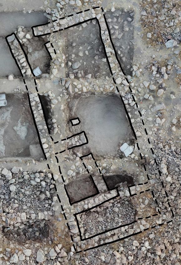
Casemate Wall System in Field A
Field A (Figure 15) was excavated in 2018 under the supervision of Constance
Gane. Squares A1 and A3 were opened on the western edge of the site. Part of Kh.
Safra’s casemate wall system was uncovered in Square A1 while Square A3 revealed two
rooms built along the eastern side of the inner casemate wall. Parts of both Square 1 and
16Figure 12. Location of Kh. Safra (Gregor, Ray, and Moody: fig. 1).
17Figure 13. Topographic map of Kh. Safra with excavation fields (Gregor, Ray, and
Moody: fig. 2).
Figure 14. The casemate wall system of Kh. Safra (Gregor, Ray, and Moody: fig. 3).
18Figure 15. Kh. Safra Field A (Gregor et al. 2018: fig. 4).
Square 3 were excavated down to bedrock. The direct relationship between Square 3 and
the casemate wall system is currently unclear, however architecture visible from the
surface seems to suggest that the inner casemate wall in Square 1 is also serves as the
western wall of the southern room in Square 3. Both squares will be discussed further,
below.
Field A Square 1 – Casemate Wall System
Square A1 revealed two rooms between an inner (A1.3) and outer (A1.4)
casemate wall (running north/south), separated by a transverse wall (A1.5) with another
transverse wall (A1.10) along the balk to the north (both running east/west). Each wall is
19primarily composed of unhewn limestone and chert and constructed in the boulder &
chink style. The inner casemate wall (A1.3) has one row with a width between 0.6 and
0.65 m and between four and five courses with a height between 0.95 and 1.5 m (Safra
Excavation Archives). The outer wall (A1.4) consists of two rows with a width between
0.95 and 1.0 m and seven courses with a height between 0.95 and 1.55 m (Safra
Excavation Archives). The transverse wall (A1.5) consists of one row with a width of
0.60 m and four to six courses with a height of 1.4 m (Safra Excavation Archives). The
transverse wall (A1.10) exhibits two rows with a width of 0.95 m and six courses with a
height between 1.1 and 1.3 m (Safra Excavation Archives).
These casemate walls were built directly on the bedrock (A1.14-15) with a red-
bricky material (A1.16) used to fill in the bedrock’s natural crevices. This may have been
the first occupation layer as early Iron Age I ceramics were found lying directly on the
bedrock (Gregor et al. 2018: 3). Early Iron Age I ceramics, stone grinders and pestles,
and animal bones were discovered between the bedrock and a beaten-earth surface (A1.9,
11) in both the northern and southern casemate rooms (Safra Excavation Archives). The
pottery remains above this surface were a mix of Iron Age I, Iron Age II and Byzantine-
period (Safra Excavation Archives). There was also evidence in this layer of “mudbrick
superstructure collapse, indicating a violent disruption of occupation” (Gregor et al.
2018: 3).
Field A Square 3
Square A3 (along the east side of the inner casemate wall) consists of a northern
and southern room connected with a doorway (A3.25). Consistent with Square A1, early
Iron Age I pottery and red-bricky material (A3.21, 24) was found between the bedrock
20(A3.18, 23) and a surface, in this case a plastered floor (A3.21). Early Iron Age I
ceramics were found imbedded in the plaster and covered with a thick layer of ash (up to
0.50 cm) in the southern room. Debris found between this layer of ash (A3.20) and a
Byzantine beaten earth surface (A3.17) suggest a time of abandonment. Walls dating to
the Byzantine period (A3.8-10; 15-16) with another beaten earth surface (A3.11) indicate
a “relatively well-established Byzantine-period occupation on this part of the site”
(Gregor et al. 2018: 4).
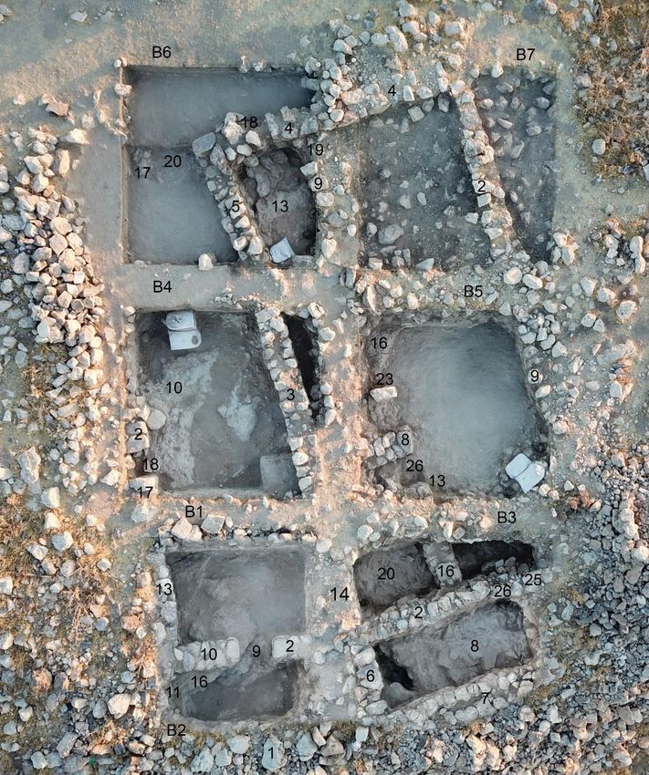
Casemate Wall System in Field B
Field B (Figure 16) was excavated in the 2018 and 2019 seasons under the
supervision of Paul Ray. Three squares (B1-3) were opened in 2018 and four squares
(B4-7) were opened in 2019 on the southwestern edge of the site. Square B1 was
completely excavated in 2018. Square B2 was not excavated but was used to trace the
outer casemate wall. Square B3 was partly excavated in 2018 and completed in 2019.
Squares B4-6 were completely excavated in 2019 and B7 was opened in 2019 but was
uncompleted. These seven squares consisted of two broad rooms between the outer and
inner casemate walls which were separated by transverse walls with “parts of two
buildings, consisting of long room-structures, sharing one wall, and connected with the
broad-room casemates previously excavated” (Gregor, Ray, and Moody 2019: 3).
Field B Squares 1 and 3 – Casemate Wall System
The casemate wall system in Field B was excavated solely in Squares B1 and B3
(B2 was unexcavated but the outer casemate wall which was visible on the surface was
assigned a locus, Locus 1). The casemate wall system is composed of two broad rooms
21Figure 16. Kh. Safra Field B (Gregor, Ray, and Moody: fig. 5).
22(one in Square B1 and one in Square B3) between an inner (B1.2, 10=B3.2, 25) and outer
(B2.1=B3.7) casemate wall (running east/west) with two transverse walls (B1.11; B3.6;
running north/south) along the western balks of their respective squares. Each wall is
primarily composed of unhewn limestone and chert and constructed in the boulder &
chink style. The inner casemate wall consists of one row with a width between 0.5 and
0.8 m and between four and seven courses with a height between 0.9 and 1.4 m (Safra
Excavation Archives). The outer wall exhibits two rows with a width between 1.0 and 1.1
m and four to six courses with a height between 1.3 and 1.4 m (Safra Excavation
Archives). The transverse wall (B1.11) is partially imbedded in the western balk with one
row (the width of which is yet, unknown) and three to five courses with a height between
1.0 and 1.1 m (Safra Excavation Archives). The transverse wall (B3.6) is one row with a
width between 0.55 and 0.6 m and four to six courses with a height between 1.6 and 1.8
m (Safra Excavation Archives).
Excavations discovered that the two-row outer wall (B3.7) was first built directly
on bedrock (B3.8) in preparation for occupation. The one-row inner wall (B1.2, 10=B3.2,
25) and cross walls (B1.11; B3.6) were added once the crevices in the bedrock
(B1.16=B3.8) were filled with a hard, red-bricky, material (unexcavated in Square 1;
B3.5), much like what was found in Field A. A doorway with stone thresholds (B1.9) was
excavated in Square B1 leading from the casemate room through the inner casemate wall
(B1.2, 10) and into Building 1, which was further uncovered in Squares B4 and B6.
Another doorway (B3.26) was found but unexcavated in Square B3, which led from the
casemate to Building 2. The thresholds in Square B1, “connected with both beaten-earth
surfaces… to keep everything level on both sides of the wall” (Gregor et al. 2018: 4).
23A destruction layer occurred during the early Iron Age II (B1.12; B3.5) by what was most
likely an earthquake causing wall collapse (Figure 17). There seems to be a period of
abandonment after this with possible late Iron Age II (evidenced by ceramics) and
Byzantine squatter activities (B3.12-13).
Figure 17. Kh. Safra Field B3 east balk (Gregor et al. 2018: fig. 6).
Field B Squares 1-6 – Buildings 1 and 2
Building 1 (the western structure) can be traced from Square B1 through Square
B4 and into Square B6. This building’s western wall can be traced through Square B1
and some of Square B4 but disappears into the west balk of Square B4, just beyond what
appears to be a western entrance to the building. The northern wall of Building 1 is
represented by what “appears to be the bedrock footing (B6.17) to a ghost wall, on its
western end, again disappearing in the balk” (Gregor, Ray, and Moody 2019: 3). The
eastern wall of Building 1 is shared with Building 2. Building 2 can be outlined through
24Squares B3-7. Each wall is completely exposed except for portions still within the
unexcavated balks (B3.6, 14=B4.3=B6.5; B5.9=B7.2). The northwest corner of the
northern wall has an entrance was excavated (B6.18) with a small room (B5.8, 13=B3.16)
on the building’s southwestern side which subdivided the building with a doorway
(B5.26) into the main room on the eastern side. North of this room excavators discovered
a pillar (B5.23) siting directly on bedrock (B5.16), a short section of a wall (B6.9) that
disappears into the balk, and another entrance (B6.19). How these elements are related
are, as of yet, unknown and require further excavation.
Several beaten-earth surfaces were uncovered in Buildings 1 and 2. Above the
red-bricky fill material (B1.15; B3.11) used to fill in the crevices of the bedrock
(B1.16=17=B3.8) is the first occupation layer (Building 1, B4.16, 19, 21 and B6.12, 21;
Building 2, B3.23, B5.25) with two beaten-earth surfaces (Building 1, B1.5=B4.12 and
B6.10; Building 2, B3.21 B5.19=20, 21) laid throughout Iron Age I (B1.5=B4.12). A
destruction by a conflagration (B5.22) is evident in Building 2 between these two
occupational layers but is not seen in Building 1. Another beaten-earth surface
(B1.6=B4.7) was above a fill layer (Building 1, B1.7=B4.11; Building 2, B5.24), possibly
laid during the early Iron Age II. Afterwards, a possible earthquake left this area
abandoned (evidenced by considerable ruins) with possible later squatter activities and
post-abandonment earth material (B1.1, 3; B3.1, 2) collecting since.
Casemate Wall System in Field C
Field C (Figure 18) was supervised by Trisha Broy and is in the southeastern
corner of the site. Two squares (C1 and C2) were opened in 2018. Part of the site’s
casemate wall system was found in Square C1 with parts of several rooms built along the
25Figure 18. Kh. Safra Field C (Gregor et al. 2018: fig. 7).
26northern side of the inner casemate wall excavated in Squares C1 and C2. The direct
relationship between the casemate wall system and the rooms to the north is currently
unclear but evidence of a doorway leading out of the casemate room indicates that there
is a relationship. This field has a roughly similar architectural layout to what was found in
Field B.
Field C Square 1 – Casemate Wall System
Square C1 revealed one full casemate room and part of another room between an
inner (C1.3) and outer (C1.4) casemate wall (running east/west), separated by a
transverse wall (C1.12) with another transverse wall (C1.20) along the eastern balk (both
running north/south). Less is known about the casemate wall system in Field C compared
to Fields A and B because neither of the casemate rooms were excavated down to
bedrock. Each wall was primarily composed of unhewn limestone and chert and
constructed in the boulder & chink style. The inner casemate wall (C1.3) consists of one
row with an unknown width, unknown number of courses, and unknown height (Safra
Excavation Archives). The outer wall (C1.4) yielded two rows with a width between 0.9
and 1.0 m, an unknown number of courses, and unknown height (Safra Excavation
Archives). The transverse wall (C1.12) is one row with an unknown width, unknown
number of courses, and unknown height (Safra Excavation Archives). The transverse
wall (C1.20) has an unknown number of rows with an unknown width, unknown number
of courses, and unknown height (Safra Excavation Archives). Phasing within the
casemate wall system is unclear with predominantly Iron Age I but some Iron Age II
pottery found along with a slingstone (Safra Excavation Archives).
27A small area located outside the outer casemate wall was excavated down to
bedrock as part of Square C1 (Safra Excavation Archives). Above the bedrock was more
of the red-bricky material which indicates that the casemate wall system in Field C was
built in much the same manner as in Fields A and B. These casemate walls were built
directly on the bedrock and the largely sterile red-bricky material used to fill in crevices
(Safra Excavation Archives). Soil above this material was also fairly sterile with a small
amount of Iron Age II pottery found (Safra Excavation Archives).
The north-western corner of Square C1 is part of a room that was further exposed
in Square C2. The findings from this room will be discussed in the following section.
Field C Square 1 and 2 – Rooms North of Casemate Wall System
Multiple rooms were excavated north of the inner casemate wall and the phasing
remained consistent in each. A continuation of what we have seen in every other field, a
red-bricky material (C1.17; C2.17, 25) was used to flatten the bedrock (C1.18; C2.20, 22,
28), and LBII/early Iron Age I transitional pottery found on top of this material indicates
it was used as a surface (Safra Excavation Archives). A 0.10 m thick destruction layer
(C1.16; C2.16, 18, 23-24) sealed this material and contained several broken ceramic
vessels dating to the Iron Age I or earlier and many objects used in domestic food
preparation (Figure 19).
A beaten earth floor created a second occupational level above this destruction
layer (Safra Excavation Archives). The entrance (C1.19=23) which leads from the larger
of the two casemate rooms, through the inner casemate wall, and into a large room, was
blocked during this time. A second entrance (C2.27) was blocked in the northwest corner
of Square C2 which connects a small room with a possible staircase (C2.21). The surface
28Figure 19. Kh. Safra Field C1 north balk (Gregor et al. 2018: fig. 8).
in this small room contained a roof-roller, a pair of bronze bangles, and predominantly
early Iron Age I and Iron Age I flat-lying pottery sherds (Safra Excavation Archives). A
series of ash layers were discovered above this occupational layer (C1.9-11, 14; C2.4-6,
9) indicating a second conflagration with ceramics dating to the Iron Age II (also evident
in the casemate rooms). There was then a period of abandonment (C1.1-2, 6-8; C2.1-2, 7)
with a few scattered Iron Age II ceramics and a significant amount of wall tumble
(Gregor et al. 2018: 5-6).
Casemate Wall System in Field D
Field D (Figure 20), excavated in the 2018 and 2019 seasons, is on the
northernmost edge of Kh. Safra and was supervised by Jacob Moody. Three squares were
opened in 2018 (D1-3) while only D1 and D2 were fully excavated that year. Excavation
in D3 was completed and three new squares were opened and excavated (D4-6) in 2019.
Wall lines were visible on the surface and guided the placement of these squares in an
attempt to better understand the architecture (specifically the reasoning behind the
29Figure 20. Kh. Safra Field D (Gregor, Ray, and Moody: fig. 7).
use of such large wall stones) and to excavate between the casemate walls (Gregor et al.
2018: 6; Gregor, Ray, and Moody 2019: 5). The earth matrix in Field D is extremely
shallow, only 0.10 m deep in some places, making it easy for each square to reach
bedrock. Balks were removed in certain places which provided a clearer picture of the
architectural details, but sections in Squares D3 and D4 were left unexcavated since they
were located outside the outer casemate wall. These six squares revealed one casemate
room (and part of another), part of a gate complex, and several interior rooms.
Field D Squares 3, 4, and 6 – Casemate Wall System
In Squares D3, D4, and D6 one complete casemate room and the southwestern
corner of another room were uncovered between an inner (D6.7, 15) and outer
30(D3.14=D4.2=D5.7) casemate wall (running east/west), separated by a transverse wall
(D6.14) with another transverse wall (D3.19), excavated in the eastern balk of Square D3
(both running north/south). Each wall was primarily composed of unhewn limestone and
chert and constructed in the boulder and chink style. The inner casemate wall (D6.7, 15)
consisted of one row with an unknown width, unknown number of courses, and unknown
height (Safra Excavation Archives). The outer wall (D3.14=D4.2=D5.7) consisted of one
to two rows with a width of 0.8 m and two courses with a height between 0.65 and 0.85
m (Safra Excavation Archives). The transverse wall (D6.14) exhibits one row with an
unknown width, unknown number of courses, and unknown height (Safra Excavation
Archives). The transverse wall (D3.19) is also one row with an unknown width, unknown
number of courses, and unknown height (Safra Excavation Archives).
Field D Squares 3 and 5 – City Gate Complex
A portion of a city gate complex was excavated in the 2019 season. The western
half of the gate was found in Square D3 with the eastern half found in Square D5. A 2.5
m break with a threshold (D3.20=D5.17) was found in the outer city wall (D3.14; D5.7).
Paving stones (D3.21; D5.20), smooth from wear, were discovered north of the threshold.
Both west and east of the gate, two long rectangular stones (D3.20; D5.21) run
perpendicular to the threshold. A cobble/beaten earth surface (D5.19) was found south of
the threshold which was used to level the surface of the bedrock (D3.16). Two large walls
(D1.2; D3.2; D5.8=15) with benches (D3.9; D5.16) lined a roadway from the gate into
the settlement. A long room was found on the other side of those walls on both the east
and west of the street. The room on the east was completely excavated with a doorway
leading from the room to the street and a layer of ash evident. The room on the west was
31only partially excavated but seems to parallel the eastern room (Gregor, Ray, and Moody
2019: 6).
Field D Squares 1, 2, and 6 – Interior Buildings/Phasing
Squares D1, D2, and part of Square D6 were excavated in 2018 and revealed
several rooms forming at least two buildings (Gregor et al. 2018: 6). The phasing inside
these rooms is fairly consistent with the rest of the site, and presented the clearest picture
of the history of Field D. The bedrock (D1.5, 9, 13; D2.7, 12, 16; D3.16, 18; D4.7; D5.5,
11, 14; D6.5, 8) was filled in with red-bricky material (D1.6, 12; D2.5, 8, 13; D3.13, 17;
D4.6; D5.9; D6.4, 12) upon which the walls (D1.2, 10, 11; D2.2, 6, 9; D3.2, 14, 19; D4.2;
D5.4; D6.7, 11, 14-16) were laid, similarly to Fields A-C. On top of this material, flat-
lying early Iron Age I diagnostic sherds were found in D2.8, indicating the first
occupational layer (D1.8; 14; D3.11; D5.4, 19; D6.13). In 2018, the southeastern room in
Square D1 was found to have “part of an early Iron Age I biconical jar and several
grinding stones, pounders, and a possible hob” (Gregor et al. 2018: 6). However, it was
discovered that this room had no doorway when the northern balk of Square D2 was
removed in the 2019 season. Further excavation is needed to determine the function of
these rooms.
Evidence of a conflagration was found with ashy layers present above the first
occupational layer. There are no clear occupation layers after the destruction phase
indicating either erosion or an abandonment phase (D1.3, 4, 7; D2.3, 4, 11, 14; D3.4-8,
10, 12, 15; D4.3-5; D5.2, 3, 10, 12, 13, 18; D6.2, 3, 6, 9, 10). The erosion/abandonment
layers presented mostly Iron Age I pottery with a few Iron Age II sherds. The topsoil
above this contained Iron Age I and II pottery with two Byzantine-period body sherds.
32Summary of Casemate Wall System
A freestanding casemate wall system was discovered in each of the four
excavation fields with the walls in Fields A-C excavated in 2018 and the walls in Field D
excavated in 2019. These walls were consistently constructed with large field stone and
small chink stones and created ca. 5.0-6.5 m long x 2.0-2.25 m wide broad rooms
(Gregor, Ray, and Moody 2019: 2). They were built directly on uneven bedrock with the
crevices in the bedrock being “filled with a densely-packed, sterile, red-bricky-like
material, lacking material culture” (Gregor, Ray, and Moody 2019: 2). The walls
themselves vary only slightly in thickness. The one to two-row outer wall is ca. 0.90-1.10
m thick. The one-row inner wall is ca. 0.50-0.80 m thick. The single-row cross walls are
ca. 0.55-0.95 m thick. Fields B-D have revealed entryways built into the inner wall that
connect the broad rooms of the casemate into rooms of another structure built just inside
the inner wall. The initial construction of the casemate wall system dates to the early Iron
Age I in each field based on the flat-lying pottery found on the earliest occupational
surface (Gregor, Ray, and Moody 2019: 3).
Preliminary Conclusions
The first settlement at Kh. Safra was established in the early Iron Age I. Pottery
forms indicate this could have been as early as the 13th century B.C. The inhabitants
flattened out the bedrock and filled the crevices with a red-bricky material upon which
they built a casemate-style city wall. This settlement was destroyed by fire during Iron
Age I as evidenced by thick ash layers which were found in each field. A second
settlement (possibly built by the same people who built the first settlement) established
themselves at Kh. Safra shortly after and remained until the site was destroyed again
33sometime in the early Iron Age II most likely by an earthquake. The site was abandoned
after this potential earthquake destruction. Evidence of a possible squatter occupation
during this period of abandonment is seen in the presence of some late Iron Age sherds.
Kh. Safra remained abandoned until the Byzantine period. A significant structure was
built in Field A, pitting activities occurred in Field B, and surface sherds were found
throughout each field, all dating to the Byzantine period. The site was then abandoned for
the final time with no further evidence of occupation after the Byzantine period.
Excavations in the first two seasons revealed 445 objects (Gregor et al. 2018: 8;
Gregor, Ray, and Moody 2019: 7). Of those objects, 245 were related to agricultural
activities, 48 were textile objects, 17 were pieces of jewelry, 10 were recreational
artifacts (i.e., gaming pieces and buzz toys), and 8 were related to warfare activities
(Figure 21). The small finds, as well as the site’s fortifications, indicate that Kh. Safra
was most likely a typical domestic settlement with a focus on farming and herding
activities, especially during the first two occupations.
KHIRBET SAFRA OBJECTS (2018-2019)
Recreational, 10 Warfare, 8
Jewelry, 17
Textile, 48
Agricultural,
245
Figure 21. Chart representing objects found in 2018 and 2019 seasons at Khirbat Safra.
34CHAPTER 4
IRON AGE I CASEMATE WALL SYSTEMS IN TRANSJORDAN
There are four other sites in Transjordan where casemate wall systems dating to
Iron Age I have been found. Khirbat al-Ma’mariyah, Khirbat al-Mudayna al-‘Aliya,
Khirbat al-Mudayna al-Mu’arrajah, and Khirbat al-Lahun are all located on the Karak
Plateau, between 27 and 46 km southeast of Kh. Safra (Figure 22). A brief introduction to
each site, a history of their excavation, and a presentation of the available data on each
site’s casemate wall system will be discussed in this chapter.
Khirbat al-Ma’mariyah
Khirbat al-Ma’mariyah (31°24’46.0”N 35°49’17.0”E; Figure 23) was discovered
in 2000 by Friedbert Ninow as part of the Wadi ash-Shkafiya Survey and a few small
sondages were carried out from 2002 to 2005 (Ninow 2008: 81). The site is on a high
ridge that rises from the wide bed of the Wadi al-Mujib and overlooks the point where the
Wadi ash-Shkafiya empties into the southern branch of the Wadi al-Mujib (Figure 24;
Ninow 2004a: 436). According to Ninow, it is “essentially a one-period site and dates to
the Iron I Age (ca. 1200-1000 BCE) …. Whereas all the other Iron I sites are found in
rather remote areas on top of the plateau, Kh. al-Ma’mariyah is situated on the crossways
of important routes that connected the northern Dhiban plateau with the southern Moabite
plateau. Most of the traffic that crosses Wadi al-Mujib had to pass by this site” (Ninow
35Kh. Safra
Kh. al-Lahun
Kh. al-Ma’mariyah
Kh. al-Mudayna al-Mu’arrajah
Kh. al-Mudayna al-‘Aliya
Figure 22. Map of sites with Iron Age I casemate wall systems in Transjordan.
36Figure 23. Aerial of Kh. al-Ma’mariyah (from David 2017: 163).
37Figure 24. Region of the Wadi ash-Shkafiya Survey (from Ninow 2006b: 147).
382007: 4). Kh. al-Ma’mariyah was built on a slope, rather than level ground with an 80 m
height difference between its eastern and western sides and forms a large triangle (David
2017: 162). In his article titled “In Search of the ‘City Which is in the Middle of the
Valley’,” Ninow proposes that Kh. al-Ma’mariyah is the unnamed settlement mentioned
in Deut 2:36, Josh 13:9, and 2 Sam 24:5 (Ninow 2002a: 125-127).
A massive casemate wall with a width of nearly 5.0 m serves as the site’s main
fortification with the outer wall having a width of 1.2 m. The casemate walls are well
preserved. The southern wall is almost complete, while erosion occurring in the lower
settlement has caused a few small sections of the northern wall and most of the eastern
wall to disappear (Ninow 2004a: 436). Despite the erosion, nearly 300 m of city wall is
traceable on both the northern and southern walls (Ninow 2006a: 465).
The upper settlement is dominated by a citadel (24 m x 17 m; Figure 25) which is
integrated into the casemate walls with the outer casemate wall also being the outer wall
of the citadel (Ninow 2004b: 259). The entrance (B2) to the citadel is in the area where
the northern casemate wall (W4000) connects to the citadel. This wall had a width of 1.3
to 1.4 m (Ninow 2004b: 262). This entrance (beginning at 1.65 m wide and eventually
becoming nearly 3.0 m wide) leads to a spacious courtyard (A2) in the middle of the
citadel. The western side of the citadel had several small rooms (A1/R1, A3/R2, R3)
which were full of stone debris. This led Ninow to conclude that at least this section of
the citadel had two floors (Ninow 2004b: 260-61). Excavations discovered that the outer
casemate wall (W1000) on the southern side of the citadel runs into the eastern wall
(W400) of the citadel rather than being incorporated into the citadel’s architecture like
39You can also read