February 2021:
Prolonged U.S.
Freeze &
Winter Weather
Event
←
→
Page content transcription
If your browser does not render page correctly, please read the page content below
February 2021: Prolonged U.S. Freeze & Winter Weather Event
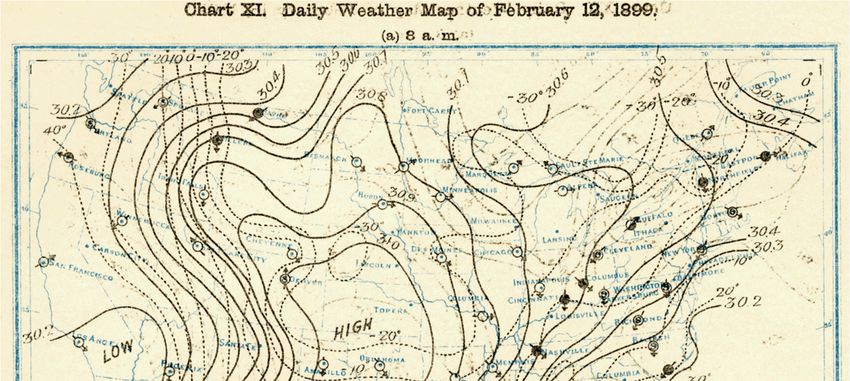
Table of Contents
Overview                                     3

Background Science                           3

Observed Weather Conditions & Event Review   5

Historical Context                           9

Why was the damage in Texas so extensive?    11

The Role of Climate Change                   15

Catastrophe Model Performance                17

Final Thoughts                               18

Contact Information                          20

February 12-20, 2021: U.S. Winter Weather         2
Overview
A broad swath of the United States endured one of its most prolonged periods of significant cold in recent memory
from February 12-20, 2021. The combination of heavy snowfall and ice only amplified the resultant winter weather
impacts. The state of Texas was hardest hit as a historic volume of damage from frozen / burst pipes and subsequent
insurance claims were incurred in nearly every county of the state. Officially, there were nearly 200 U.S. freeze-
related fatalities, though unofficial reports suggest as many as 700 people died. A catastrophic shutdown of the
state’s infrastructure grid prompted even more impacts via business interruption. While extended loss development
remains ongoing, this has already become the costliest winter weather-related event for the insurance industry on
record. Total insurance claims payouts – including those from residential, commercial, and agribusiness entities –
were expected to approach USD15 billion. The overall direct U.S. economic impact was estimated at USD22 billion.

Background Science
The beginnings of the Mid-February cold spell and coinciding winter storms can be traced to early January 2021. It
was during this time that an intrusion of warm air into the Arctic prompted a significant disruption of the Polar
Vortex. This warming in the mid-levels of the atmosphere – known as “Sudden Stratospheric Warming” (SSW) – is
known to cause a normally strong (stable) Polar Vortex to weaken and become wavier as pieces (lobes) break off
and sink southward into various parts of North America, Europe, or Asia. The Antarctic also features its own Polar
Vortex. Reminder: A strong Polar Vortex means it is locked in place; while a weak Polar Vortex leads to bouts of cold
in areas in the mid-latitudes.

As seen in the graphic below, the purple color represents geopotential height, which is indicative of higher pressure
that typically corresponds to well-above normal temperatures that mix down to the surface.

When lobes of the Polar Vortex shift southward, this can result in a “wavy” jet stream pattern that can dip well into
the southern United States. How far south the lobe sinks or how prolonged the period of cold lasts is dependent on
the intensity of the cold air dome and air flow patterns at the mid- and upper- levels of the atmosphere. With the
SSW event lasting through much of January, the likelihood of a Polar Vortex event in the United States grew as
forecast models began to pick up on the risk by early February.

February 12-20, 2021: U.S. Winter Weather                                                                               3
By early February, the atmosphere at the higher latitudes across Siberia and Northern Canada continued to feature
persistent building of high pressure. This high-pressure system helped shift the Polar Vortex towards the North
Atlantic Ocean. Another important feature that played into the eventual rush of cold air southward into the United
States was the Artic Oscillation (AO). The AO Index highlights differences in atmospheric pressure patterns at
latitudes surrounding the North Pole. When the AO is positive, this means that the mid-latitude jet stream is stronger
and that keeps the coldest air closer to the North Pole. When it is negative, it reflects a weaker and “wavier” jet
stream that can produce often frigid air that rushes south into the mid-latitude region – defined as the area between
the Arctic Circle and the Tropics.

As seen in the graphic below – black line represents observed AO and red lines indicate ensemble forecasts – the AO
had remained negative during much of the winter months. However, the AO reached a significant minimum during
the second week of February. The AO was nearly five standard deviations lower than normal. This set the stage for a
major dip in the jet stream that would essentially “open the freezer door” for a major lobe of the Polar Vortex and
accompanying cold air to sink southward into the United States. Building high pressure to the north of the lobe
would become the key factor in prohibiting the cold air from retreating and remain settled over Texas and the
Central U.S. for several days.

                                                                                                       Source: NOAA

February 12-20, 2021: U.S. Winter Weather                                                                             4
Observed Weather Conditions & Event Review
Note: The dominant driver of incurred impacts across the United States during period of February 12-20 was the
Polar Vortex. The persistence of cold air was the primary cause of most damaging impacts in Texas and elsewhere in
the Southern Plains and Southeast. Further damage elsewhere in the Pacific Northwest, Rockies, Northern Plains,
Midwest, and Mid-Atlantic resulted from the cold air in tandem with bouts of heavy snow, freezing rain, and ice.

As the jet stream initially began to dip towards the
south out of Siberia, it coincided with an area of low
pressure that came ashore in the Pacific Northwest
on February 12-13. This prompted a particularly
intense heavy snow and ice storm that led to
widespread power outages and property damage in
Oregon and Washington. The low-pressure area
would later shift southeastward through the Rockies
and into the Plains while triggering additional
snowfall and help pull down much colder air via the
Polar Vortex.

Once the cold air engulfed nearly two-thirds of the
United States, the resultant pattern of cold would
remain generally stagnant from February 12-19. The
graphic on the top right shows the persistent
“blocking” pattern at the upper levels of the
atmosphere during the peak of the cold from
February 11-16. The red indicates an area of high
pressure. It is clearly seen that three distinct areas in
the eastern Pacific Ocean, Northern Canada, and the
                                                            Feb 11-16 upper-level analysis; red is high pressure (Source: Tropical Tidbits)
western Atlantic Ocean kept the airmass in place for
several consecutive days. The graphic on the bottom
right shows the breadth of the surface high pressure
ridge extending down into northern Mexico.

As the jet stream sank southward into Texas, with
ample moisture tracking around the southern
periphery of the jet, this helped initiate the
development of several areas of low pressure. These
storms would eventually prompt heavy
accumulating snowfall, freezing rain, ice, and even
severe thunderstorms across the Rockies, Plains,
Midwest, Southeast, Mid-Atlantic, and Northeast
from February 12-20. More than 150 million
Americans were at one point under winter weather-
                                                                                  Surface map on February 15 (Source: NOAA)
related watches, warnings or advisories. Many
southern states are typically ill-equipped to handle impactful winter weather events since accumulating snowfall
does not happen with enough regularity to justify the cost of a snowplow fleet. However, Texas did deploy ~700
snowplows statewide during the period to clear roads and highways of accumulating snow and ice.

February 12-20, 2021: U.S. Winter Weather                                                                                               5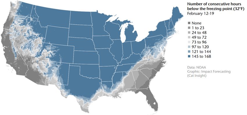
The dome of Arctic air associated with the Polar Vortex resulted in a prolonged and historic stretch of abnormally
cold temperatures and dangerous wind chills. Localized daily temperature departures approaching and surpassing
30 to 40 degrees (°F) below normal were observed for several consecutive days. The peak minimum air temperature
during the stretch was -50.0°F (-45.5°C) near Ely, Minnesota on February 14. During the mornings of February 15-
17, sub-freezing temperatures were reported across the Gulf Coast. Nearly 3,000 individual daily low temperature
records were set throughout the U.S. during the entire cold outbreak.

The table below highlights daily record low temperatures during the morning of February 15. This data comes
from the Weather Prediction Center (WPC).

                                   New Daily        Old Daily                                      Old Daily      Old Daily
Location                                                        Location
                                  Record (°F)     Record (°F)                                    Record (°F)    Record (°F)
Hibbing, Minnesota                        -38      -32 (1939)   Topeka, Kansas                            -9      -7 (1936)
Valentine, Nebraska                         -33    -28 (2007)   Wichita, Kansas                           -8      -5 (1936)
North Platte, Nebraska                      -29    -23 (1881)   Oklahoma City, Oklahoma                   -6       7 (1909)
Sioux City, Iowa                            -28    -20 (1936)   Wichita Falls, Texas                      -3     18 (2007)
Sioux Falls, South Dakota                   -26    -21 (1909)   Lubbock, Texas                             0       8 (1951)
Goodland, Kansas                            -23    -13 (2007)   Dallas/Fort Worth, Texas                   5     15 (1909)
La Crosse, Wisconsin                        -19    -16 (1905)   Dallas (Love Field), Texas                 7     23 (1951)
Colorado Spring, Colorado                   -16     -8 (1895)   Austin, Texas                              8     20 (1909)
Lincoln, Nebraska                           -16    -11 (1978)   San Antonio, Texas                         9     21 (1909)
Omaha, Nebraska                             -15    -12 (1936)   Tupelo, Mississippi                      13      15 (1943)
Dodge City, Kansas                          -14    -10 (1861)   Victoria, Texas                          14      22 (1909)
Kansas City, Missouri                       -10     -6 (1936)   Houston, Texas                           17      18 (1905)
Amarillo, Texas                             -10     -6 (1895)   Corpus Christi, Texas                    17      25 (1895)

                                                                      While the cold was primarily highlighted across
                                                                      Texas, the expansive breadth of the airmass
                                                                      affected a significant portion of the country that
                                                                      extended from the Rockies to the Gulf Coast. The
                                                                      only part of the country not directly affected was
                                                                      in the Florida peninsula. On February 14, the
                                                                      morning (12:00 UTC) temperature difference
                                                                      between Minneapolis and Miami was 94.5°F
                                                                      (34.7°C), the 4th largest on record since these
                                                                      records began being kept in 1973. The record U.S.
                                                                      differential of 102.9°F (39.4°C) was set on
                                                                      February 2, 1996.

                                                                      Among five of the coldest U.S. outbreaks dating to
                                                                      the late 1800s, here is a list of the coldest single-
                                                                      day average temperature per event (Lower 48):

                                                                      December 24, 1983: 9.3°F (-12.6°C)
                                                                      February 11, 1899: 10.5°F (-11.4°C)
                                                                      December 22, 1989: 11.9°F (-11.2°C)
                                                                      February 15, 2021: 16.7°F (-8.5°C)
                                                                      January 21, 1985: 17.1°F (-8.3°C)

February 12-20, 2021: U.S. Winter Weather                                                                                 6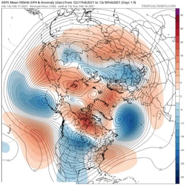
The graphic below highlights the number of consecutive hours which the United States endured temperatures
below the freezing point: 32°F (0°C). A significant portion of the country was affected by seven consecutive days of
below-freezing temperatures, including most of the state of Texas.

The state of Texas served as the epicenter of the cold weather outbreak. The daily temperature map below shows
several days in which northern and central sections of Texas failed to see temperatures average beyond 10 to 15°F
(-12 to -9°C). The intensity of the cold wave put extreme pressure on the state electrical grid as well as pipe and fire
sprinkler systems.

February 12-20, 2021: U.S. Winter Weather                                                                                  7
While the primary focus was on the cold aspect, there was also major damage reported in several states due to
heavy snow and ice. For example, Chicago, Illinois had more than 10 inches (25 centimeters) of snow on the ground
for 25 consecutive days, the fourth-longest such streak on record. This resulted in many reports of collapsed roofs.

Estimated U.S. snowfall accumulation (in)                                        72-hour snowfall accumulation (in)
February 4 12:00 UTC – February 17 12:00 UTC                                     Ending February 16 12:00 UTC

 Seattle

                                                                                                             Chicago

                                                           New York City
                                                 Chicago

                                                                           ≤1
                                                                           1-2
                                        Dallas                             2-4         Dallas
                                                                           4-8
                                                                           8 - 12
                                                                           12 - 24
 Data: NOAA/NOHRSC                                                         24 - 26
 Graphic: Impact Forecasting (Cat Insight)
                                                                           > 36

On February 16, 2021, the U.S. Lower 48 had snow covering 73.2 percent of the landmass. This marked the highest
single-day total since records began being kept in 2003 and surpassing the previous record of 71 percent on January
12, 2011.

Important Note: NOAA maintains a policy of not naming U.S. winter storms, and one which Aon follows given the
agency being viewed as the “official” source on such matters. The agency previously released a statement in 2013 on
the subject: “The National Weather Service does not name winter storms because a winter storm's impact can vary
from one location to another, and storms can weaken and redevelop, making it difficult to define where one ends and
another begins.”

February 12-20, 2021: U.S. Winter Weather                                                                              8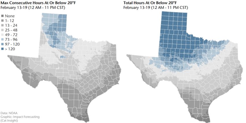
Historical Context: Texas
While the significance of the February 2021 winter weather event in Texas cannot be minimized, it is important to
put this into proper historical context. A large portion of the state endured sub-freezing temperatures for nearly
seven consecutive days, which is a historically momentous occurrence that will long be remembered. However, the
question arises as to whether this set any all-time minimum temperature records for various major cities in Texas.
The answer, perhaps surprisingly, is no.
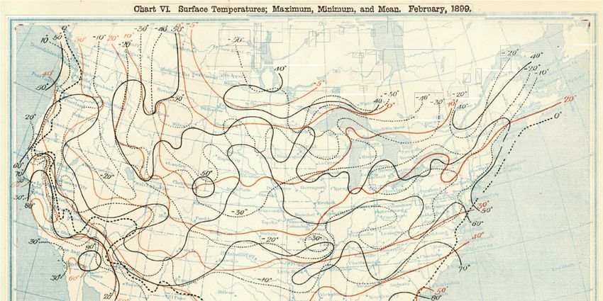
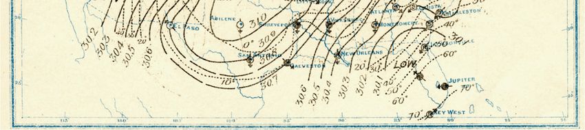
As the graphic highlights below, Texas has in fact endured colder individual stretches of arctic air – likely related to
the Polar Vortex – during various periods dating to the late 1800s. The coldest and most widespread outbreak in the
state occurred in February 1899. Of the seven select major Texas cities or metroplexes shown in the table, it is seen
that with the exception of Abilene, every other location set a minimum high temperature, minimum low
temperature, or a minimum daily average temperature on either February 11, 12, or 13 in 1899.
See the next page for maps from NOAA’s Monthly Weather Review that show the morning surface weather map on
February 12, 1899 and the monthly maximum / minimum / average tempeartures for February to see the extent of
the cold.
Data: NOAA & U.S. Census Bureau | Graphic: Impact Forecasting (Cat Insight)
Additional major cold snaps affected the state in the 1940s and 1950s, but in modern times, the events of December
1989 and February 2011 were most memorable prior to February 2021. From a damage impact perspective, the
February 2021 event will be far and away more substantial than the 1989 or 2011 events. Perhaps the most obvious
reason centers on the explosive population boom that Texas has seen during the past 25 years. For example, the
Dallas / Fort Worth metroplex and Austin (city) have each doubled its population since 1989.
The primary driver of increased direct financial damage (losses) across the United States and Texas has long been the
continued growth of population and exposure into highly vulnerable locations. But as climate change continues to
create more extreme volatility in the behavior of weather events, the combination with the exposure changes only
enhances the overall risk of loss and potential humanitarian disaster. This is exactly what happened with the
February 2021 event. The unprecedented longevity of the cold snap in Texas undoubtedly played a lead role in the
impacts being so significant but given how many more people live in the state now than ever before, a much larger
number of people were affected.
February 12-20, 2021: U.S. Winter Weather 9
February 12-20, 2021: U.S. Winter Weather 10
Why was the damage in Texas so extensive?
Much has been communicated around the size and scope of impacts across the state of Texas. The Insurance
Council of Texas has reported that the volume of claims is among the highest in state history and rivals the 700,000+
during Hurricane Harvey in 2017. The question, however, is why and how were the impacts so extensive?
The problems were amplified by several factors beyond the cold weather itself. This includes an inadequately
weatherized electrical grid, limited preparation for a winter weather event at such magnitude, and a lack of
proper investment into infrastructure maintenance to handle increasingly volatile weather conditions in a
climate change environment. Texas continues to endure a population boom that is already adding additional stress
on the electrical grid during heatwaves or periods of cold as usage requirements further grows. However, the grid
has typically performed better during heatwaves.
Prior to February 2021, the last significant cold spell in February 2011 also resulted in rolling blackouts that affected
more than three-quarters of the state. After that event, various studies were conducted – including the North
American Electric Reliability Corporation (NERC) and the Federal Energy Regulatory Commission (FERC) – that
recommended Texas upgrade its electrical infrastructure to prevent such occurrence(s) in the future. These
“winterized” recommendations were never fulfilled as the state balked at the potential cost associated with the
improvements and required regulation. Similar recommendations were overlooked following another major cold
spell and subsequent outage event in December 1989.
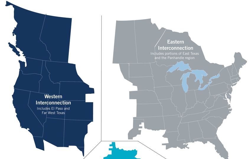
As seen on the previous page, Texas is the only state that has intentionally isolated its power grid from the rest of the
United States. While small portions of Texas are tied to the “Eastern” and “Western” power grids, most of the state
is an independent entity. This was done to keep Texas separate from U.S. federal oversight and regulatory rules. It
also makes the state highly vulnerable to massive grid disruptions since it is not easily able to import energy from
other states. At the height of the event, Texas energy companies reported a record 69,150 megawatts of energy
demand on February 14. The incredible demand led to the initiation of rotating outages beginning on February 15
that barely managed to keep the entire grid from collapsing due to overuse. More than 5 million customers lost
electricity at the peak as pipes, water lines and valves froze at dozens of power plants and nuclear gas facilities. Non-
winterized wind turbines also froze.
Texas has a single grid operator – Electric Reliability Council of Texas (ERCOT) – that manages and balances the
supply / demand of the state-wide grid. It is responsible for providing electricity to 90 percent of the state that is part
of ERCOT’s independent system. Since Texas operates as a deregulated power grid, it means that no single company
owns the power plants, transmission lines, or distribution networks. There are independent companies that conduct
electricity generation, provide retail electricity that is sold to residential and commercial interests, and transmission
companies transport the power.
Given the complexity of this set-up, it can create significant challenges when the grid is faced with a crisis. In fact,
ERCOT noted that it was “seconds and minutes” from a catastrophic blackout in February 2021 that may have
impacted most of Texas for an extended period of time. This would have resulted in even more catastrophic and
prolonged impacts.
North American Power Grid (Source: ERCOT)
February 12-20, 2021: U.S. Winter Weather 11At least 356 facilities were forced to go offline at various
points during the freeze, which equaled 46,000
megawatts of power. This compares to the 241
facilities (plants) that froze during the 2011 event. That
event resulted in rolling blackouts that affected 4.4
million customers. Following the 2011 event, a new
state law was passed that asked power generators to
voluntarily submit winterization plans each year to the
Public Utility Commission of Texas. However, a lack of
enforcement and regulation led to most generation
companies not taking the proper precautions to
prepare for the next cold event.
The electricity issues further resulted in 7 million Texas
residents in 110 counties being placed under boil-
water notices as the lack of power shut down 332 local
water treatment systems.
So how did impacts to the infrastructure grid lead to
Texas power outage scale on February 16 (Source: PowerOutage.us)
so much physical damage to residential and
commercial properties in Texas? A research study from the University of Illinois in 1996 determined that
uninsulated pipes in an attic were at risk of freezing when the ambient temperature dropped to and below 20°F (-
6.7°C)1. This worst-case scenario provided a temperature threshold to monitor for the possibility of burst pipes,
predominantly in the southern states. Historically, building practices in Southern U.S. states typically offer less
protection to pipes from extreme winter weather events. This can often lead to more incurred losses from burst
pipes during prolonged cold events.
While air temperature plays a paramount role in determining a pipe’s susceptibility to freezing, it is important to also
consider wind speed, the placement of pipes, the amount of insulation, the integrity of the structure, and the indoor
temperature among other factors. The same research indicated that unwinterized copper pipes took approximately
four hours from the start of ice blockage until the pipe burst. Construction practices in Texas typically feature a
blend of PVC and copper piping.
The basic premise of how a pipe performs during extended cold blast is as follows. As water in a pipe freezes, it
begins to expand. During that expansion, it pushes outward against pipe walls until they eventually stretch enough
that it prompts a crack or outright burst. However, this is much less common than most realize. The more common
cause of pipe damage or burst involves ice formation. As the ice develops it expands along the length of the pipe. As
this expansion occurs – including during the thawing/warming process – and the ice expands within the closed
copper or PVC piping, this causes a considerable increase in “downstream” water pressure that grows until the pipe
eventually ruptures. These ruptures occur at the weakest part of the pipe and between the ice blockage and the
closed faucet. This also means that pipe bursts usually happen away from the actual freeze location given the
accumulated pressure elsewhere along the cylinder.
If pipes are adequately protected along their entire length with proper construction and placement within the
building’s insulation – or insulation on the pipe itself – then they are usually safe. This also is true if pipes are heated
or continuous drips of water from the faucet to prevent ice formation during cold snaps.
1
https://www.ideals.illinois.edu/handle/2142/54757
February 12-20, 2021: U.S. Winter Weather 12The below pictures from a local Texas television station show the performance of both copper and PVC piping
during the February 2021 cold spell. The copper piping froze and burst, which resulted in extensive indoor flooding.
The PVC pipe did not fully burst, but cold-related cracking led to a failure in performance. This type of damage was
extensive across virtually every county in Texas, and commonplace in single-family homes, apartment complexes,
commercial facilities, and other structures. Plumbers from neighboring states were summoned to Texas to help with
the enormous volume of project requests.
Frozen / burst copper pipe (left) and frozen / cracked PVC pipe (right) in Garland, Texas (Source: KERA TV)
The other damaging widespread component of the outbreak involved fire sprinklers. In newer constructed homes,
and standard in apartment complexes, fire sprinklers are commonplace. During the cold spell, fire sprinklers and its
piping froze within the ceiling and eventually burst. This led to water cascading from ceilings and even more
physical structure damage and indoor content impacts.
Relating this information with hourly data from the NOAA Unrestricted Mesoscale Analysis (URMA) one can
generalize localities across Texas which experienced an increased likelihood for burst pipes during the February
Arctic blast based on the longevity of cold temperatures. The graphics below highlight how much of the state
endured various timescales of temperatures at or below 20°F (-6.7°C).
February 12-20, 2021: U.S. Winter Weather 13These maps incorporated hourly temperature data from the peak of the Arctic blast, however it was possible for temperature to dip below 20°F (-6.7°C) outside of the period of analysis. Given the considerable area of Texas which endured temperatures below the 20°F (-6.7°C) threshold – in combination with the prolonged period of electricity outages – it is not surprising that so many instances of frozen and/or burst pipes and indoor fire sprinklers occurred. The question moving forward will be how this latest cold outbreak may lead to changes in construction and regulatory practices. Given how little regulation or building code enforcement that currently exists in Texas, there is much room for improvement in terms of construction practices and more code consistency on a statewide level. Texas is unique in its territorial size and the various weather risks it faces. In the past decade alone, Texas has endured substantial impacts from severe convective storms (tornadoes and hail), hurricanes, droughts, wildfires, and now winter weather. How the state decides to better mitigate against these growing risks will play a key role in weather-related event preparation and subsequent dependencies on the federal government for post-event disaster assistance. Texas Energy Generation Fossil fuel-based energy sources account for 75 percent of Texas’ output; while renewable energy sources such as wind, solar, or hydro accounted for 25 percent in 2020. Texas continues to improve its clean energy output on an annual basis. For the first time on record, wind (23 percent) accounted for a higher portion of the state’s energy than coal (18 percent) in 2020. Natural gas production led with 46 percent. Energy officials are more regularly touting the prospect of converting fossil fuel operations and infrastructure into options such as large solar farms, renewable energy storage facilities, and new discoveries around green hydrogen production. As seen in the graphic below, there has been a significant shift in energy generation type in Texas during the past decade. Coal accounted for 40 percent of energy generation in 2010, but as previously noted, fell to 18 percent in 2020. Renewables such as wind and solar continue to account for a larger portion on an annual basis. Wind alone jumped from 8 percent in 2010 to 23 percent in 2020. February 12-20, 2021: U.S. Winter Weather 14
The Role of Climate Change
While a popular question in the aftermath of the event, there remains considerable uncertainty around the direct link
to climate change. The attribution of climate change to the Polar Vortex in becoming more unstable during the
winter months has become an increasingly studied area in academic research. Some initial conclusions do suggest
that the continued accelerated warming seen in the Arctic is causing more rapid glacial decay and sea ice melt.
Such trends appear to be linked in the disruption of larger scale weather patterns across the Northern
Hemisphere. This type of pattern disruption can result in more bouts of extreme cold during the winter months and
prolonged heat waves during the summer months.
As highlighted earlier in this piece, the Polar Vortex only engulfs parts of North America, Europe, or Asia when it is
weakened, and lobes split southward out of the Arctic. The initiating feature is called “Sudden Stratospheric
Warming (SSW)”. With more atmospheric warmth intruding into the higher latitudes, some scientific research –
while not yet conclusive – does appear to be suggesting that SSW events may become more frequent given the
expectation of wavier jet streams acting as a conveyor belt of warm air into the Arctic. While the intensity and
longevity of the February 2021 cold snap may remain an outlier in the near-term, the probability of occurrence may
grow as the atmosphere becomes more unstable in its behavior. Such behavior spawning significant weather
extremes can be referred to as “weather weirding”.
"While there have been claims that cold extremes like the February 2021 cold outbreak are becoming more frequent
because of climate change, these claims are strongly debated and I myself don't find the evidence for them
compelling. But regardless, this event, though extreme, was not outside the range of what was known to be possible
based on historical experience. So, the failure of the power system can only be attributed to a choice to not invest in
resilience against extreme but foreseeable events."
Adam Sobel, Columbia University
With the usage of Global Climate Model (GCM) output becoming more prevalent within the insurance industry
and other financial-based institutions to make decisions of projected future climate scenarios, there are some
obvious potential roadblocks. GCMs are primarily meant to simulate oceanic and atmospheric changes at a global
scale with a temporal view looking decades into the future. For the insurance industry and the financial investment /
asset manager / real estate communities, the greatest need for guidance is in a much shorter timescale – on the
range of 1 to 5 years – and at a much more downscaled view (including down to an asset location level).
These models are also not developed to simulate individual weather events. Such a simulation would be found
using a Numerical Weather Prediction (NWP) model for short-term forecasting. Thus, a GCM would not be able to
simulate or “micro-forecast” the February 12-20, 2021 U.S. winter weather event. It would, however, be able to
speak to how the overall behavior of the atmosphere will evolve in future decades.
Practical Use Cases of a Global Climate Model (GCM)
Base Data: Atmosphere, land surface, ocean, and sea ice components
Global Climate Complex simulations seeking to discover how changes in any of the four components
Model (GCM) can lead to larger-scale climate disruptions
Solutions meant to project future climate environments on a decadal or centurial scale
February 12-20, 2021: U.S. Winter Weather 15The question becomes how to best use GCMs and which future climate scenario. With the pending shift from CMIP
5 to CMIP 6 datasets in conjunction with the 2021 / 2022 release of the Sixth Assessment Report of the
Intergovernmental Panel on Climate Change (IPCC), this will lead to new and updated views of a future climate.
However, in the noted context of the insurance industry and other financial markets, any of the scenarios – from the
most optimistic to the most pessimistic carbon dioxide emission scenario – the differences in the first 10 years of
simulations are not likely to produce dramatically different results from the current “base” environment.
As regulatory bodies begin to more aggressively require companies to highlight their climate change and ESG
solutions via various stress tests or sustainability requirements, the importance of properly utilizing GCM output will
only become more important. A potential misuse of a GCM solution may lead to an over/under estimation of a
specific type of risk.
The final, and perhaps most important, challenge around any climate change analysis surrounds the topic of
attribution and the quantification of the impact – either via the hazard itself or the resultant financial cost. Weather
has always and will always occur. While the fingerprints of climate change become more apparent on an annual
basis as regions around the world continue to set new temperature, precipitation, storm intensity, sea level rise, and
financial loss records, the reality is that our ability to specifically quantify the net-effect of climate change
remains limited at this time.
Technology has accelerated scientific research in its capacity to simulate historical and future-state oceanic and
atmospheric environments. This has and will allow better clues in moving us forward in reducing the uncertainty
around climate change and its impact on individual perils.
Adapted from https://www.nap.edu/catalog/21852/attribution-of-extreme-weather-events-in-the-context-of-climate-change
As the graphic above shows, there are varying levels of confidence around climate change impacts on each peril.
Temperature and precipitation-based impacts are best understood; while severe convective storm has the least
known effects. When combining the climate change influence of individual events with the increasing population
and exposure seen in some of the most highly vulnerable areas on the planet, it brings us to a single conclusion that
natural peril risk is growing. The need to properly plan, invest, and implement mitigation strategies against
these heightened risks has never been more imperative than it is today. The next major weather catastrophe is a
matter of “when”, not “if”.
February 12-20, 2021: U.S. Winter Weather 16Catastrophe Model Performance Most catastrophe modeling solutions have a stable and robust winter storm component as part of the suite of modeled perils. However, the extent and duration of the February winter events presented many challenges for estimating insured losses using these models. Initially, the long duration of power outages due to crippled infrastructure left millions of homes from South Dakota to Texas without power for several days. Such an extended downtime led to substantial downstream impacts, such as burst pipes, which are not explicitly captured in most catastrophe model solutions. Additionally, this event was by all accounts an extreme “tail” event. This means that the likelihood of such an occurrence was very rare on an anticipated loss perspective. Most publicly available modeled insured loss estimates for the state of Texas were at most a 1-in-1,000 year, or 0.1 percent exceedance probability event. As seen in the August 10, 2020 U.S. Midwest Derecho, the current suite of catastrophe model solutions struggles with tail event losses given heightened sensitivity to exposure concentrations at a sub-model grid resolution; which are further exacerbated by other non-modeled causes of loss. Further complicating the “model miss” picture is the expected long tail for this event, as more damage has and will be uncovered over time as some commercial structures remain unoccupied due to the ongoing COVID-19 pandemic. Lingering water damage, mold, and other social inflation-related factors such as a shortage of fully licensed plumbers and other required labor. It remains to be seen how effective the models will be at determining the final insured loss from the winter storm. While it remains too early to provide an absolute view of “model miss”, it is anticipated that the values will be reasonably as significant as it is for large hurricane events – if not greater. February 12-20, 2021: U.S. Winter Weather 17
Final Thoughts & Commentary on Loss Estimates
From a financial loss perspective, this will end as one of the more challenging and prolonged weather events that
the insurance industry has endured in recent memory. Most of the complexity surrounds varying levels of
uncertainty around the claims filing process, final per-claim average payout, and liability. There has been a
“hurricane-level” of insurance claims already filed in Texas (nearly 600,000), which is in the ballpark of the 700,000+
claims which were filed following Hurricane Harvey in 2017. The final industry cost is not likely to be known for until
the end of 2021 or early 2022 as a period of prolonged loss development (loss creep) continues to be observed. It is
standard practice that the biggest natural disaster events often record loss development periods that extend well
beyond a full calendar year.

Extended business interruption was ongoing into the summer of 2021, which highlighted the lengthy loss
development. Plus, as mentioned previously, there is a high likelihood of numerous liability cases that will involve
extensive litigation. Such a scenario is likely to resemble what was seen in California following the 2017 and 2018
wildfire seasons, though given tort reform of recent years in Texas may limit the number of liability lawsuits filed.

Additional enhanced losses may further result from the price of lumber. At the end of May 2021, the price of lumber
was the highest seasonally adjusted level on record (dating to the late 1960s). Given how much repair work will be
required to homes and businesses across Texas and elsewhere in the U.S. within the ongoing COVID-19
environment and a high level of natural disaster occurrence – in addition to elevated home construction projects
throughout the country – this has led to heightened demand for limited supply.

This has already become the most expensive period of winter storm losses for the insurance industry on record. It
has far surpassed the USD3.7 billion incurred during the March 1993 “Storm of the Century”. Current available
data suggests that insured losses will approach USD15 billion. These losses include direct physical damage to
property and direct net-loss business interruption from shutdown commercial entities and/or lost indoor contents
due to power outages. The other issue with the February 2021 event surrounds underinsurance, insurance coverage
gaps, and time clauses. These topics will directly result in a higher than normal “protection gap” for the winter
storm peril, meaning that a significant portion of direct damage or net loss business interruption is not likely to be
covered by insurance. This will also be true for the extensive losses incurred to the agribusiness sector (which could
see economic damage to crops in Texas alone exceeding USD1 billion).

February 12-20, 2021: U.S. Winter Weather                                                                               18
It is currently anticipated that economic losses from the February 12-20 stretch of winter weather (and severe
thunderstorms in the Southeast) will approach USD22 billion. Freeze-related damage to property and agriculture in
Mexico was also minimally anticipated to exceed another USD1 billion.

The event has completely altered the view of winter weather as a “secondary peril” and now joins the ranks of
severe convective storm, wildfire, and drought as perils setting new insured loss records for the U.S. insurance
industry in just the past decade alone.

The graphic below highlights previous calendar year winter weather-related losses in the United States dating to
1990. In total aggregate losses, it ranks behind Tropical Cyclone, Severe Weather, Flooding, and Drought as the
costliest for the country during that time. The February 2021 event has an overall loss total that surpasses the
costliest combined calendar year economic loss for the peril (1993; USD13.1 billion).

February 12-20, 2021: U.S. Winter Weather                                                                          19
Contact Information
                                            Dan Dick
Adam Podlaha
                                            Executive Managing Director
Head of Impact Forecasting
                                            Global Head of Catastrophe Management
Reinsurance Solutions
                                            Reinsurance Solutions
Aon
                                            Aon
adam.podlaha@aon.com
                                            dan.dick@aon.com

Steve Bowen                                 Liz Henderson
Managing Director                           Senior Managing Director
Head of Catastrophe Insight                 Reinsurance Solutions
Impact Forecasting                          Aon
Aon                                         elizabeth.henderson@aon.com
steven.bowen@aon.com

February 12-20, 2021: U.S. Winter Weather                                           20
About Aon Aon plc (NYSE: AON) is a leading global professional services firm providing a broad range of risk, retirement and health solutions. Our 50,000 colleagues in 120 countries empower results for clients by using proprietary data and analytics to deliver insights that reduce volatility and improve performance. © Aon plc 2021. All rights reserved. The information contained herein and the statements expressed are of a general nature and are not intended to address the circumstances of any particular individual or entity. Although we endeavor to provide accurate and timely information and use sources we consider reliable, there can be no guarantee that such information is accurate as of the date it is received or that it will continue to be accurate in the future. No one should act on such information without appropriate professional advice after a thorough examination of the particular situation. Copyright © by Impact Forecasting® No claim to original government works. The text and graphics of this publication are provided for informational purposes only. While Impact Forecasting® has tried to provide accurate and timely information, inadvertent technical inaccuracies and typographical errors may exist, and Impact Forecasting® does not warrant that the information is accurate, complete or current. The data presented at this site is intended to convey only general information on current natural perils and must not be used to make life-or-death decisions or decisions relating to the protection of property, as the data may not be accurate. Please listen to official information sources for current storm information. This data has no official status and should not be used for emergency response decision-making under any circumstances. Cat Alerts use publicly available data from the internet and other sources. Impact Forecasting® summarizes this publicly available information for the convenience of those individuals who have contacted Impact Forecasting® and expressed an interest in natural catastrophes of various types. To find out more about Impact Forecasting or to sign up for the Cat Reports, visit Impact Forecasting’s webpage at impactforecasting.com. Copyright © by Aon plc. All rights reserved. No part of this document may be reproduced, stored in a retrieval system, or transmitted in any form or by any means, electronic, mechanical, photocopying, recording or otherwise. Impact Forecasting® is a wholly owned subsidiary of Aon plc. February 12-20, 2021: U.S. Winter Weather 21
You can also read