FINAL CONFERENCE WITH PILOT SHOWCASES - MARCH 2017 - SDI4APPS PROJECT
←
→
Page content transcription
If your browser does not render page correctly, please read the page content below

Final Conference
with Pilot Showcases
       March 2017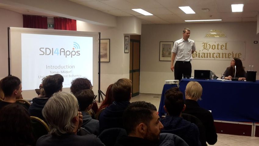
DELIVERABLE
              Project Acronym: SDI4Apps
      Grant Agreement number: 621129
              Project Full Title: Uptake of Open Geographic Information Through Innovative
                                  Services Based on Linked Data

        D8.6 FINAL CONFERENCE WITH PILOT

                                         SHOWCASES

                                                Revision no. 06

Authors:         Nino Paternò (STEPIM)

Project co-funded by the European Commission within the ICT Policy Support Programme

Dissemination Level

P      Public                                                                                X

C      Confidential, only for members of the consortium and the Commission Services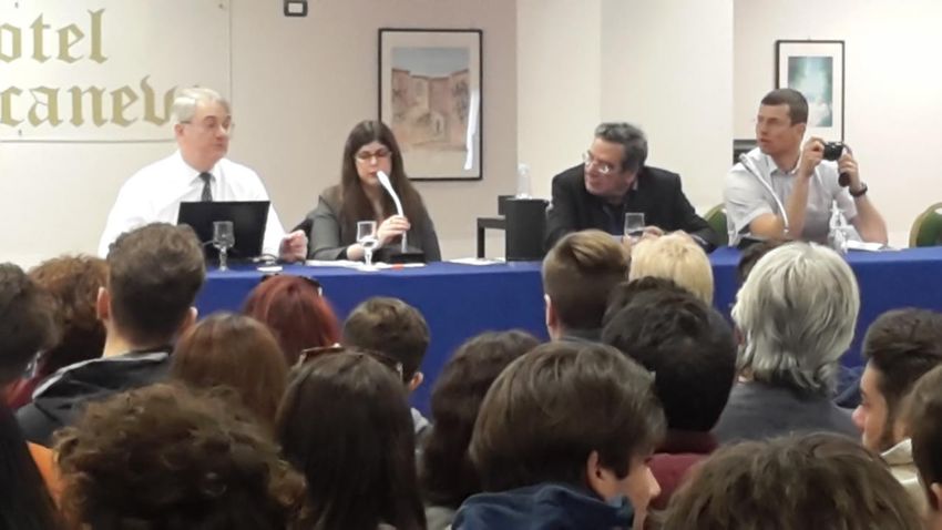
D8.6 Final Conference with Pilot Showcases

REVISION HISTORY
 Revision         Date              Author        Organisation             Description

    01         24/03/2017        Nino Paternò     STEPIM          Initial draft – table of content

    02         28/03/2017        Nino Paternò     STEPIM         Incorporation of comments from
                                                                         Cristina Marullo

    03         28/03/2017        Nino Paternò     STEPIM         Incorporation of comments from
                                                                          Tomas Mildorf

    04         28/03/2017       John O'Flaherty   MAC                    Internal review

    05         31/03/2017       Kristaps Ročāns   VDZ                    Internal review

    06         31/03/1951        Nino Paternò     STEPIM                   Final version

Statement of originality:
This deliverable contains original unpublished work except where clearly indicated
otherwise. Acknowledgement of previously published material and of the work of others
has been made through appropriate citation, quotation or both.
Disclaimer:
Views expressed in this document are those of the individuals, partners or the consortium
and do not represent the opinion of the Community.

                                 Page 3 of 19                              © SDI4Apps Consortium 2015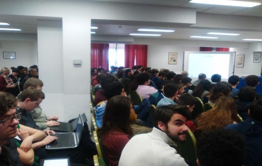
D8.6 Final Conference with Pilot Showcases

TABLE OF CONTENTS
Revision History ................................................................................................................. 3
Table of Contents .............................................................................................................. 4
List of Figures ................................................................................................................... 5
Executive Summary ............................................................................................................ 6
1    Introduction ................................................................................................................ 7
2    Final conference meeting ............................................................................................... 8
3    Conclusions................................................................................................................ 19

                                           Page 4 of 19                                             © SDI4Apps Consortium 2015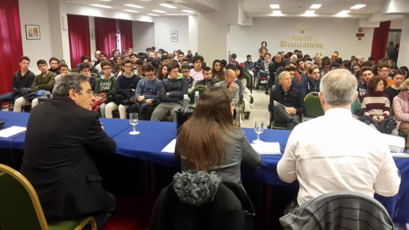
D8.6 Final Conference with Pilot Showcases

LIST OF FIGURES
Figure 1 Tomas Mildorf /University of West Bohemia, SDI4Apps project Coordinator/ ............................ 8
Figure 2 John O'Flaherty (MAC), NIno Paternò (STEPIM) ............................................................... 10
Figure 3 John O'Flaherty (MAC), Nino Paternò (STEPIM), Tomas Mildorf (UWB) .................................... 11
Figure 4 An image from the conference ................................................................................... 12
Figure 5 An image from the conference ................................................................................... 13
Figure 6 An image from the conference ................................................................................... 13
Figure 7 Major of Nicolosi Antonino Borzì and vice-major of Mascalucia Fabio Cantarella ............................ 14
Figure 8 Articles from local press .......................................................................................... 15

                                         Page 5 of 19                                           © SDI4Apps Consortium 2015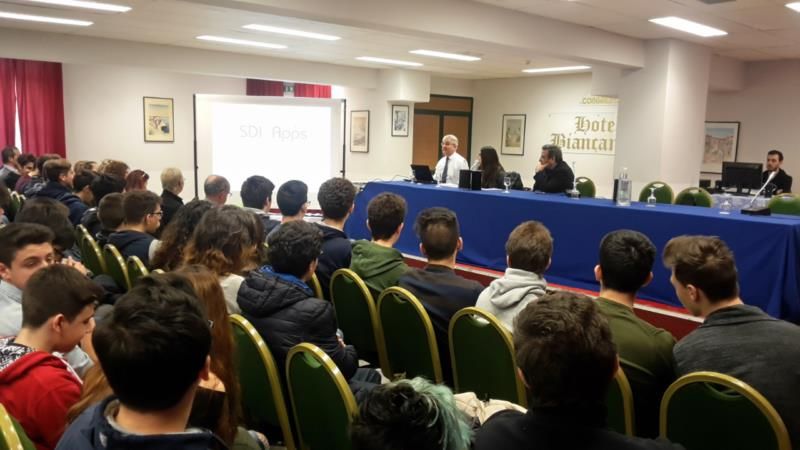
D8.6 Final Conference with Pilot Showcases

EXECUTIVE SUMMARY
This is a report from the final conference with pilot showcases of the SDI4Apps project.
The final conference was held in Nicolosi (CT) in Sicily on 15 March 2017 and hosted by
STEPIM. During the conference, the project results, pilot showcases and contest results
where to an audience of 137 people – local municipal authorities and companies, project
partners and large numbers of students. The conference was streamed live. The
recording is available at http://www.galetnasud.it/sdi4apps-final-meeting/.

                                 Page 6 of 19                     © SDI4Apps Consortium 2015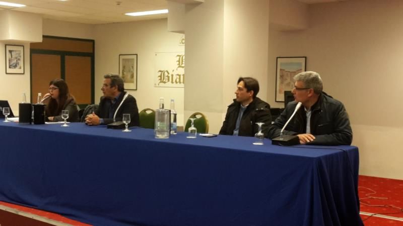
D8.6 Final Conference with Pilot Showcases

1 INTRODUCTION
The final conference took place on March 15 from 9am to 12.30pm at the Aula
Conference of the Biancave hotel in Nicolosi (Sicily). The conference was attended by
over 100 students and numerous representatives of the political world and the Sicilian
production companies. During this event, the project pilots were presented, and the
employment opportunities of young people through use of the project's output were
highlighted. An ample space was given to the use of the project's output by politicians
and production companies that were present at the conference.

                                 Page 7 of 19                       © SDI4Apps Consortium 2015
D8.6 Final Conference with Pilot Showcases
2 FINAL CONFERENCE MEETING
On March 15, from 9am to 12.30pm at the conference hotel. The conference was aimed
to disseminate the results of the project and targeted at students, politicians and
companies. During the conference, the SDI4Apps pilots were presented to the audience.
In particular, and beside the pilots’ technical characteristics, the employment
opportunities arising from the results of the project and the use of the same for
territorial socio-economic development with particular reference to tourism were
highlighted.
Figure 1 Tomas Mildorf /University of West Bohemia, SDI4Apps project Coordinator/
The final meeting received recognition speeches from local politicians including Antonino
Borzì – major of Nicolosi and Fabio Cantarella – vice major of Mascalucia. They
highlighted the importance of the project and the results to the region.The project was
further introduced by Tomas Mildorf from the University of West Bohemia, the SDI4Apps
project coordinator. Tomas outlined the general concept of the project, used
methodology, the main results, planned sustainability and further exploitation strategy.
Following the introduction, other presentations from project partners followed:
• Irish pilot – Pilot 1 Easy Data Access (John J O’Flaherty, MAC)
• Ecosystem Services Evaluation (Eng. Martin Tuchyňa, SAZP)
• Open Land Use Map, Smart Points of Interest (SPOI), Open Transport Map (Ota
Cerba, UWB)
• SPOI Application Demo (Raitis Bērziņš, BOSC)
• INSPIRE4Youth (Alfredo Lembo, HYPERBOREA)
Page 8 of 19 © SDI4Apps Consortium 2015D8.6 Final Conference with Pilot Showcases
Easy Data Access pilot, was presented by Dr. John J O’Flaherty, Technical Director of
MAC Ltd. The Easy Data Access Pilot aims to support easy access to existing services using
the SDI4Apps platform API solution, which supports easy collection of information using
smart phones and integrates this information into current SDIs, by implementing the
European Tourism Indicators System (ETIS) and Ground Truthing services. The report of
the Irish Pilot focused on the:
- European Tourism Indicator System (ETIS)
- Ground Truthing Tourism Sites Apps
The Irish Pilot Services, built on Open Data using the Platform, are focused on the Burren
National GeoPark and its users in Ireland, and involve, as mentioned before, the following
services, chosen by users and stakeholders: European Tourism Indicator System (ETIS) and
Ground Truthing Tourism Sites Apps. Validation by Users focused on Tourism for
Conservation.
ETIS is a new EU standard that is a locally owned and led process for monitoring,
managing and enhancing the sustainability of a tourism destination to streamline and
enhance the current manual system by providing a distributed open data-driven Apps
system.
SDI4Apps enables the ETIS Web service and Apps for the Burren and European GeoParks
Network.
The Burren National GeoPark consists of 1,500 hectares on the west coast of Ireland, it is
managed by the Irish National Parks and Wildlife Service, and is an unique area of high
conservation value containing many habitats of international importance, including
limestone pavement, calcareous grassland, oligotrophic lakes, turloughs, hazel scrub &
ash/hazel woodland. It involves many Communities and Europe-wide environmental
issues.
Thanks to this pilot service, GeoPark Manager can select the ETIS options relevant to her
Park and the content is automatically published in Survey Apps for visitors, residents and
enterprises. A Web service Dashboard shows how the destination is performing as per the
ETIS framework. Each of the stakeholders surveys can be accessed with different URLs,
one for each type of interested person.
Based on user feedback the pilot also involved development of Heritage Sites Reporting
and GeoPark Management Portal, enabled by use of the SDI4Apps platform. The Ground-
Truth Protected Heritage sites & Monuments service; in particular enable field officers,
visitors and people interested in their local heritage, to seek out and ground truth
Protected Monument sites. These Mobile Apps to support Tourism for Conservation is built
on the using the following open data: ETIS (European Tourism Indicator System) Dataset,
Irish National Monuments Dataset, External Open Datasets automatically used. MAC (as an
SME) plans to continue the services through partnership with funding from public or
private organizations, selling professional services and through Dual-licensing.
Page 9 of 19 © SDI4Apps Consortium 2015D8.6 Final Conference with Pilot Showcases
Figure 2 John O'Flaherty (MAC), NIno Paternò (STEPIM)
The results of the Ecosystem Services Evaluation pilot was presented by Martin Tuchyňa
(SAZP), pilot provided possibilities for the mapping and evaluation of the state of
ecosystems and services in the national territory of the member states. This facilitates
the public decision makers and private sector stakeholders’ better understand how
the economy and society depend on healthy, resilient and productive ecosystems.
The main user demand, before teh project, come from research and the public sector
domain, mainly from authorities involved in the EU Biodiversity Strategy to 2020. That
pilot has realized a common interface, in connection to the MAES, to facilitate access and
exchange of the knowledge and resources related to the topic of ESS with the possibility
visualizing the ecosystem services values for a particular location of interest on national
level. Another important result was also to ensure a wider participation by the non-
governmental sector aiming to improve the quality of life. The main stakeholders
identify during the pilot realization are the following: public authorities, individuals from
public sector, non governmental authorities, R&D office and citizens.
Page 10 of 19 © SDI4Apps Consortium 2015D8.6 Final Conference with Pilot Showcases
Figure 3 John O'Flaherty (MAC), Nino Paternò (STEPIM), Tomas Mildorf (UWB)
The Open Land Use Map, was presented by Ota Cerba (UWB), as an initiative started by
the European project “Plan4business” and currently developed in the SDI4Apps project.
The idea is to make a pan European map of land use as detailed as possible, depending on
open data availability. The key feature is that the data are open. The following open data
sources were used to create the Czech OLU: Digital cadastre data (RUIAN, highest level of
detail), Land Parcel Identification System (LPIS), Urban Atlas and Corine Land Cover.
Similar to the Czech Republic, a Slovakian and Latvian OLU has also been produced using
the following open datasets: Open Street Map and Urban Atlas.
SPOI Application Demo was presented by Raitis Bērziņš (BOSC). The SDI4Apps project
has collected a large number of points of interest (POIs). The Smart Points of Interest
(SPOI) represents a seamless and open resource of POIs covering all the world. Its
principal target has been to provide information for cycling as Linked data together with
other data sets containing road networks. But the current version can be used for any
purpose related to tourism. Raitis showed the data model for POIs as a basis for
harmonization of external data sources into this data model. The current version of the
SPOI data set includes a harmonized combination of selected Open Street Map
data, GeoNames.org, experimental geo-ontologies developed at the University of West
Bohemia and local data. The data model follows the recommendations for RDF data sets,
semantic data, and Linked Data as well as the data model published in Points of Interest
Core.
The Pilot 5, INSPIRE4Youth, presented by Dr.Alfredo Lembo (HYPER), supports
creativity, technical capabilities, skills, knowledge and also relations, through the sharing
of spatial based content and educational materials on the environment using new
methods of digital cartography that enable it to go beyond linguistic barriers. Using
principles of Linked Open Data, INSPIRE4Youth offers new possibilities of analyzing
Page 11 of 19 © SDI4Apps Consortium 2015D8.6 Final Conference with Pilot Showcases
relationship among different types of objects. The pilot is focused on building an
Environmental and Geographical Web based Atlas and educational quizzes based on
utilization of Geospatial data, Linked Open data and other environmental data (maps) for
educational and gaming purposes.
The report provided an overview of tests and their results from the first phase of the
project implementation. A scenario based test plan for every component was prepared by
identifying both functional and non-functional tests.
The CCSS Redmine system was used for management of the testing, bug tracking and the
process of bug fixing. Furthermore, it is worth pointing out that the Code Camps and
Hackathons organized by the Consortium contributed to gathering feedback from both
internal and external developers and therefore to the consolidation of the overall testing
process for the first release of the project technical report.
The application is providing the necessary functionality for displaying geographic data on
a map and then creating a map composition (a thematic map) that can contain several
data layers. After the map composition is created, i.e. detailed definition and metadata
of each layer of the composition along with the composition itself, it can be saved as a
JSON-styled text document. Then, this document can be read and visualized by an
HSLayers NG-based web application. So, the main purpose of the application is to share
visualized geographic data between users.
The meeting was ended with a discussion with the members of the audience about
project results usability and benefits to various stakeholders and user and a conclusions
session held the project coordinator. The final conference proved the large interest for
the results of the project and their further use by the local Sicilian stakeholders and
students and also attracted attention of the local media, further providing the
dissemination of the results.
Figure 4 An image from the conference
Page 12 of 19 © SDI4Apps Consortium 2015D8.6 Final Conference with Pilot Showcases
Figure 5 An image from the conference
Figure 6 An image from the conference
Page 13 of 19 © SDI4Apps Consortium 2015D8.6 Final Conference with Pilot Showcases
Figure 7 Major of Nicolosi Antonino Borzì and vice-major of Mascalucia Fabio Cantarella
The conference had a large following in the local press and has attracted the interest of
politicians, local administrators, representatives of local socio-economic reality.
Following are some press articles covering the conference:
Page 14 of 19 © SDI4Apps Consortium 2015D8.6 Final Conference with Pilot Showcases
Figure 8 Articles from local press
SDI4Apps final meeting. L’Europa protagonista
nell’area del GAL EtnaSud
20 marzo 2017 | Filed under: VERDE NEWS | Posted by: Giuseppe Consiglio
Mercoledì 15 marzo, presso l’hotel Biancaneve di Nicolosi, si è svolto il meeting conclusivo
del Progetto EuropeoSDI4Apps finanziato con fondi comunitari nell’ambito
del Programma quadro per l’innovazione e la competitività. Il progetto della
durata di 3 anni, ha ricevuto un finanziamento di circa 3 milioni di euro ed ha coinvolto 18
partner da tutta Europa in particolare da Repubblica Ceca, Norvegia, Lettonia, Irlanda,
Slovacchia, Grecia e Cipro. Tra i partner italiani oltre a STEPIM S.A.S dell’Ing. Nino
Paternò, anche il Sant’Anna di Pisa e la società Hyperborea.
Il progetto nato per realizzare un sistema integrato di condivisione di dati spaziali basato
sulle esperienze dei singoli utenti, ha consentito attraverso la realizzazione di 6 app pilota di
creare dei potenziali supporti alle piccole e medie imprese, in particolare attive nel settore
del turismo, ma anche per la realizzazione di modelli di business sostenibile e per testare
nuovi approcci per la condivisione dei dati. Nel corso dell’incontro, sono stati presentati i
risultati del progetto e le 6 app pilota realizzate:Easy data access, Open Smart Tourist
Data, Open Sensor Network, Open Land Use Map Through VGI, Open
INSPIRE4Youth ed Ecosystem services evaluation
Il convegno, organizzato e moderato dall’Ing. Nino Paternò che ha aperto i lavori ed
introdotto gli esperti internazionali succedutisi nel corso della mattinata, ha visto una
grande partecipazione: in sala erano presenti gli studiosi, i tecnici e i rappresentanti delle
organizzazioni partner del progetto, esponenti dell’imprenditoria locale, del mondo della
cultura e dell’associazionismo ed un centinaio di studenti del liceo “Concetto Marchesi” di
Mascalucia. Tra gli amministratori locali il consigliere comunale di Mascalucia Valentina
Lombardo, il vicesindaco di Mascalucia Avv. Fabio Cantarella e il sindaco di Nicolosi Nino
Borzì.
Nel corso del suo intervento Fabio Cantarella, ha sottolineato l’importanza dell’iniziativa
per tutto il territorio, sostenendo che eventi del genere possano realmente fornire
Page 15 of 19 © SDI4Apps Consortium 2015D8.6 Final Conference with Pilot Showcases
un’opportunità di crescita attraverso momenti di condivisione con realtà anche molto
lontane, un modo insomma per avvicinare i territori etnei e soprattutto i giovani all’Europa.
Il saluto del vicesindaco è stato anche l’occasione per riaccendere i riflettori sul GAL Etna
Sud, di cui Mascalucia è il comune capofila, e sul ruolo fondamentale che il GAL avrà, non
appena sarà pienamente operativo, nell’intercettare i fondi comunitari a tutti i livelli, da
quelli regionali, in particolare per l’agricoltura, la trasformazione e commercializzazione dei
prodotti, per la crescita e l’innovazione, ai fondi nazionali, transnazionali ed europei per la
cultura, l’arte, il turismo, le piccole e medie imprese e la cooperazione internazionale.
Tutti i partecipanti ed in partiolare gli oltre 100 allievi dell’Istituto “Concetto Marchesi” di
Mascalucia hanno potuto così respirare un’aria europea ed approcciarsi a realtà
internazionali di altissimo livello nel campo della ricerca e dell’innovazione. La presenza
degli studenti è stata fortemente voluta dall’Ing. Nino Paternò e dalla dirigente dell’istituto
prof.ssa Lucia Maria Sciuto, che ha inserito l’evento nel programma alternanza scuola-
lavoro. I lavori del convegno, tenutosi in lingua inglese e in italiano con traduzione
simultanea e trasmesso in streaming, si sono conclusi con l’intervento del coordinatore del
progetto Tomas Mildorf della facoltà di Scienze Applicate della University of West Bohemia.
http://www.lafrecciaverde.it/sdi4apps-final-meeting-leuropa-protagonista-nellarea-del-
gal-etnasud /
Page 16 of 19 © SDI4Apps Consortium 2015D8.6 Final Conference with Pilot Showcases
Page 17 of 19 © SDI4Apps Consortium 2015D8.6 Final Conference with Pilot Showcases
Page 18 of 19 © SDI4Apps Consortium 2015D8.6 Final Conference with Pilot Showcases
3 CONCLUSIONS
The SDI4Apps final conference provided a very useful way to disseminate the project
results to a large audience and gain press coverage. The final conference was useful to
assess the impact of the results obtained with an audience of privileged users who are
students, politicians and local administrators. The students, with their observations, have
shown that they fully understand the utility of the pilots arising from the project for their
future employment. While politicians present at the meeting appreciated the use of the
pilot projects for tourism, environmental protection and territorial socio-economic
development. Some professors of the students attending the conference have specifically
asked to keep in touch with the project as they are extremely interested to help their
students in the topics of the SDI4Apps project and European issues in general.
Page 19 of 19 © SDI4Apps Consortium 2015You can also read