GEOSPATIAL STRATEGY 2021-2026 - Stakeholder Version MAY 2021 - National Emergency ...
←
→
Page content transcription
If your browser does not render page correctly, please read the page content below
GEOSPATIAL STRATEGY
2021-2026
Stakeholder Version
MAY 2021

DOCUMENT INFORMATION
Prepared for          Taranaki Civil Defence and Emergency Management Group

Prepared by           Teresa Gordon, Taranaki Civil Defence and Emergency Management Group Office
                      Ed Cook. Eagle Technology Group Ltd

Published by          Taranaki Civil Defence and Emergency Management Group Office
                      45 Robe Street
                      New Plymouth, 4310
                      New Zealand

ACKNOWLEDGEMENTS
We are grateful for the enthusiastic and candid participation in the development of this strategy that
occurred in several ways:

•      engagement by technical, operations and staff from territorial local authorities, regional councils
      and coordinating executive group organisations who made themselves available at short notice
      to provide feedback and attend workshops.

•     support and participation from the coordinating executive group members who signed-off the
      initial resilience fund application, and adopted the strategy in May 2021.

Their support and willingness to take part made the development of this geospatial strategy possible.

Strategy Team
An internal team from Taranaki CDEM Group were closely involved with the strategy development

Teresa Gordon of Taranaki Civil Defence and Emergency Management Group Office coordinated and led
the strategy project. Ed Cook, supported by Nathan Heazlewood of Eagle Technology Group Ltd ,
undertook the strategy development in consultation with the internal team. This included peer review
conducted by Jacob Hechter and Melissa Brooks of New Plymouth District Council, who also provided
advice and support on the objectives and overall delivery of this strategy.

For citation, please cite as follows:

Gordon, T., & Cook, E., (2021). CDEM Geospatial Strategy: 2021-2026 (p. 0-30, Rep.). New Plymouth:
Taranaki CDEM Group.

Cover page photo: © Dave Young, all other photographs: © Unsplash contributors.

DISCLAIMER
We developed this strategy in good faith using the information available to us at the time. We provide it
on the basis that the authors of the strategy are not liable to any person or organisation for any damage
or loss which may occur from acting or not acting with respect to any information or advice within this
strategy.
TABLE OF CONTENTS
Background to the Strategy                          4

     Current Operating Environment : Challenges     5

     Current Operating Environment: Opportunities   7

Geospatial Strategy to 2026                         9

     Purpose                                        10

     Vision, Aim and Priority                       10

     Structure                                      10

     Focus areas and approach                       12

     Roadmap to 2026                                14

     Objectives                                     16

Appendices                                          20

Glossary                                            28
4                                                                              TEMO I BACKGROUND TO THE STRATEGY

BACKGROUND
TO THE STRATEGY
The Taranaki Civil Defence & Emergency Management Group (CDEM) is proud of its geospatial
capability. We want to develop this further, along with the capability of our region and sector.

INTRODUCTION                                                   Common themes that emerge from the two
                                                               initiatives are the importance of interoperability and data
In recent years, there have been significant changes and       sharing. Addressing these can alleviate the challenges
initiatives highlighting the need for geospatial information   when using data. This benefits how we deal with
that affect emergency management organisations. This           emergencies by improving the underlying information,
includes the Sendai Framework for Disaster Risk Reduction      informing and driving better decision making.
(2015), which prioritises the understanding of disaster risk   GIS within the Taranaki CDEM Group is in a growth-state.
globally (section 24c). Locally, the New Zealand Govern-       Several improvements in the use of GIS have already been
ment’s Ministerial Review on Delivering better responses to    implemented during the development of this strategy.
natural disasters and other emergencies, (2018) identified     However, technology is everchanging and we cannot afford
that improved situational awareness is required across the     to delay action towards improving upon our progress going
emergency management sector. This is through a common          forward. We need to put a strategy in place to enable us to
operational picture, of which geospatial technology            plan and resource GIS in the future, optimising its use
contributes to. Both reports identified a key area of          across the region. This is including not just Civil Defence,
improvement around the information and resulting               but also within the organisations of our Coordinating
intelligence that underpins better decision making before,     Executive Group (CEG) members. The major benefits will
during and after emergencies.                                  be improvement in our situational awareness and
In New Zealand, there are two prominent initiatives focused    collective intelligence. Ultimately enabling better decision
on this. Firstly, the increase in accessibility of essential   making across the “4 R’s” of CDEM (reduction, readiness,
datasets through New Zealand’s Agency responsible for          response and recovery).
geospatial, Land Information New Zealand’s (LINZ) “Key         This Strategy sets the priorities for the development and
Datasets for Resilience” programme. Secondly, the              resourcing of GIS at the Taranaki CDEM Group for the next
formation of the advocacy group “NZ GIS for Emergency          five years (2021-2026). The overarching aims are to ensure
Management (NZGIS4EM)”, which has set the back drop for        the Group gets value for money from the investment it
a fresh look at Geographic Information Systems (GIS), and      makes, based on decisions informed by this strategy, and
the use of geospatial as a whole in emergencies.               to support the implementation of the CDEM Group Plan.
TEMO I BACKGROUND TO THE STRATEGY                                                                                              5

WHAT IS GIS?
GIS is geospatial technology and works as a framework for
gathering, managing, analysing and disseminating data.

Rooted in the science of geography, GIS integrates many
types of data. It analyses spatial location and organizes lay-
ers of information into visualisations      using maps and 3D.
With this unique capability, GIS reveals deeper insights into
data, such as patterns,      relationships, and situations. This
provides accessible displays, supporting more informed
decision makers.

WHY IS GEOSPATIAL
INTEGRAL TO EMERGENCY
MANAGEMENT?
Across the 4 R’s, there is a need for good information and
                                                                   CURRENT OPERATING
intelligence to understand and inform activities. In most
situations, understanding of location and risk in communities
                                                                   ENVIRONMENT:
and the natural and built environment is crucial to informed
decision making.                                                   CHALLENGES
Increasingly there are many ‘where’ and ‘what’
questions that need answering before, during and after an
emergency event. These questions differ depending on
contributing factors such as phase of event and audience type      UNDERSTANDING THE
but are all similar in the fact that location contributes to the
answer.                                                            APPLICATION OF
GIS, as a geospatial tool, is an enabler for data-driven           GEOSPATIAL TECHNOLOGY
decision making across all four phases of emergency
management. This is due to the location information it stores,     Geospatial software is constantly evolving, with new
and the unique insight it can provide to location-based            functionality adding to the depth of existing tools.
problems.                                                          Understanding and informing decision makers and personnel
                                                                   on what exists, and what’s possible is key to targeting effort
How location information is collected, analysed and
                                                                   in the right areas.
disseminated are all equally important. Fast progression in
GIS technology has improved the               efficiency and
effectiveness of all three of these processes. For example,
information can now be collected, analysed and disseminated        PROVIDING INTERNAL
as accessible intelligence products in near-real time.

For organisations, a holistic and coordinated approach in the
                                                                   STRUCTURE TO A NEW
design and operation of a GIS system will maximise benefits        DOMAIN
and future innovations.
                                                                   Geospatial within emergency management is now
                                                                   recognised as a subfunction within the latest iteration of
                                                                   CIMS (3rd Edition). Setting up organisational roles and
                                                                   processes to maintain and grow this subfunction is a
                                                                   challenge due to no previous work in this area.
6                                                                              TEMO I BACKGROUND TO THE STRATEGY

FINDING AND USING                                               DEFINING OUR GIS
AUTHORITATIVE SOURCES                                           USERBASE
OF THE TRUTH                                                    Geospatial technology now allows the functionality
                                                                to collaborate and engage a wider audience, from
There are many versions of datasets that are currently          external stakeholders to the general public.
available. These vary in source, completeness and when
                                                                Currently there a gaps in the identification of who needs
they were last updated. This comes from the ability of
                                                                what information, in what format and when. Geospatial
anyone, anywhere to create a dataset and share it. In a
                                                                Analysts and technical staff are no longer the userbase, it
response, the use and validation of geospatial
                                                                now extends to anyone with access to a geospatial
information is challenge. The absence of clear provenance
                                                                product.
for a source, then delays us using it for decision-making.

CONNECTING DIFFERENT                                            LIMITED NUMBER OF
DATA SOURCES AND                                                SKILLED PERSONNEL
SYSTEMS                                                         Geospatial specialists locally, and nationally are in short
                                                                supply. There is a dependency on local government
There is no consistent geospatial software platform used        specialists on to fulfil majority of geospatial tasks across
across our stakeholder group (identified in Appendix 1 and      the 4 R’s for emergency management.
2A). As a result, we do not have data immediately available
if required. Impacting our ability to answer information
needs during an event.                                          INVESTING TO IMPROVE
We have limited data standards in place for
organisations if they wish to share data. If they do, we have
                                                                EXISTING TECHNOLOGY
less capacity to integrate these into our own operating         Taranaki CDEM currently has no allocated annual budget
picture.                                                        for the ongoing procurement, resourcing and development
Data sharing arrangements and storage solutions also need       of geospatial technology. Therefore, specialists and staff
to consider privacy implications. This is due to different      have minimal time and capital available to enhance the
datasets having different levels of classification within a     existing capability.
response.
TEMO I BACKGROUND TO THE STRATEGY                                                                                             7

CURRENT OPERATING
                                                                 ALIGNS WITH CENTRAL
ENVIRONMENT:
                                                                 GOVERNMENT INITIATIVES
OPPORTUNITIES                                                    Both the National Emergency Management Agency
                                                                 (NEMA) and LINZ have ongoing work streams
                                                                 dedicated to geospatial. These include advocating for the
                                                                 use of geospatial or supporting the release of
WE HAVE INITIAL                                                  interoperable     key     information    sources     that

GEOSPATIAL CAPABILITY                                            geospatial technology can consume.

Geospatial systems are already in use for many other district
and regional council functions in Taranaki.                      GEOSPATIAL DATA IS
Taranaki CDEM, resourced in response by staff of its CEG,        READILY AVAILABLE FOR
have already demonstrated the extent of expertise available,
and the speed at which they can create tools to collect and      USE
visualise data. Simplistic risk reduction tools have also been
created in the past to conduct analysis on lifeline assets as    Central Government Open Data initiatives have been
part of a previous NEMA funded resilience project.               successful in providing New Zealand a wealth of
                                                                 information, including geospatial in ready-to-use
Recent responses such as COVID-19 have highlighted the           formats. The breadth and depth of data available, that
geospatial work of Taranaki as best practice on the world        fulfils many standing information requirements is
stage, with Harvard University singling out Taranaki CDEM’s      available for those who have software to use it. TEMO,
map detailing what key public facilities and businesses were     through its engagement on geospatial over the past few
open as one of the world’s leading examples of local             years, has created relationships with many of the
government best-practice for geospatial.                         organisations who are the source of truth for other da-
                                                                 tasets required to fulfil information needs.

THERE IS GROWING
ADOPTION OF GIS WITHIN                                           TECHNOLOGY CAN BE
THE SECTOR                                                       USED TO SUPPORT OF KEY
The COVID-19 response has highlighted the extensive
                                                                 WORKFLOWS
adoption of geospatial technology in response, both locally      Geospatial technology and software has evolved to now
and globally. This has been supported by a mandate to            support specific targeted workflows alongside it’s original
improve systems, including geospatial to provide intelligence    purpose. Being able to collect, analyse and disseminate
to reduce, respond and build back infrastructure in a way        information in a way that aligns to the Coordinated
more resilient to impacts.                                       Incident Management System (CIMS) is one example of
Across the sector, training pathways available for internal      this (see Appendix 3). With software being primarily
and stakeholder personnel to upskill to use or data or           web-based, this is opening up new possibilities for
operate geospatial software are improving. New Zealand is        intelligence sharing and improving common operational
fortunate to also have an active community advocating for        pictures. Taranaki CDEM is well placed to take advantage
best-practice for using GIS in Emergency Management              of this.
known as NZGIS4EM (New Zealand GIS for Emergency
Management).

Members of this community share, and advocate for con-
tinuous improvement of the use of the technology, which
Taranaki-based staff are leveraging, and feeding back into.
GEOSPATIAL STRATEGY
2021-2026

10                                                                           TEMO I GEOSPATIAL STRATEGY TO 2026

GEOSPATIAL
STRATEGY TO 2026
PURPOSE                                                       VISION
                                                              Our vision is that GIS becomes a key part of our common
It is recognised that a geospatial capability is not merely
                                                              operating picture for the region.
about the tools used during responses. Therefore this
strategy was designed with the following purposes in
mind.
                                                              AIM
•      Build on our progress so far                           Our aim is that as a group, we have the best-available
                                                              information at any time, that is accessible to inform our
•      Provide a sense of purpose and direction
                                                              decision-making across the 4 R’s.
•      Enhance decision making abilities from GIS

•      Focus our attention on matters that will make a
       difference                                             PRIORITY
•      Enable targeted, responsible and sustainable
       investment                                             Our immediate priority is to review, develop and invest in
                                                              an Implementation plan for using GIS in response.
•      Meet objective DRR5 in the Civil           Defence     Additionally, auditing the status of data required for this.
       Emergency Management Group Plan
TEMO I GEOSPATIAL STRATEGY TO 2026 11
OUTCOMES
TEMO and our stakeholders will be able to use GIS
information for decision making, which will involve:
1. Enabling better evidence-based decision making
using geospatial information across the 4 R’s
2. Skilled personnel to innovate and support our
investment
3. Embedded geospatial use and understanding across
our people and their activities
4. Interoperable data sources that are the best available,
and are supported by strong collaborative
relationships between data owners and the Taranaki
CDEM Group.
Our internal staff, stakeholders and communities that we STRUCTURE
serve will all benefit from these.
This Geospatial Strategy is comprised of four objectives
WHAT SUCCESS LOOKS LIKE: that acknowledge and build on gathered knowledge and
experiences to date, reflect the challenges identified by
We will know we’ve been successful when:
stakeholders, and reflect advancements in geospatial
• Our users and staff understand the use and benefit of technology and use.
geospatial information and analysis within the
The objectives are as follows:
context of Disaster Risk Reduction
• We are using, and confident in the accuracy of all our
geospatial data we use at Taranaki CDEM 1. DEVELOPING PEOPLE & PROCESSES
• Taranaki CDEM staff across all functions are confident 2. GATHER ONGOING REQUIREMENTS
in using and tasking geospatial information for 3. ENABLING INTEROPERABLE DATA
decision making
4. INVEST IN GEOSPATIAL TECHNOLOGY
• We use our geospatial platform for engaging our
communities across the 4 R’s
Each objective focuses on a key theme aimed to deliver
• We use our geospatial platform for receiving and
the best outcomes over the next five years.
sharing information with our Coordinating
Executive Group Stakeholders, other Civil Defence These objectives are introduced and shown as an
Groups and other central government agencies interconnected approach to meet our outcomes.
• Our essential elements of information, (including our Key milestones from these activities are then shown in our
minimal essential datasets) are available as overall roadmap to 2026.
geospatial data for use at any time. Each objective is then defined, which in turn are supported
• We have dedicated staffing and processes for using by deliverable activities.
geospatial in the Taranaki CDEM Group for any
response level, and timeframe.
Taranaki CDEM understands that by continuing to
demonstrate in our use of geospatial technology that we care
about what we do and how we do it, other people will
respond accordingly.12 TEMO I GEOSPATIAL STRATEGY TO 2026
SUMMARY OF OBJECTIVES
Each of these objectives focus on a key theme that will support the growth of our geospatial capabilities over the
next 5 years:
1. DEVELOPING PEOPLE AND 2. UNDERSTAND THE
PROCESSES ONGOING NEEDS OF USERS
Current and future geospatial staff need Bringing stakeholders who will be using our
their roles identified and implemented. geospatial information and tools across the
This will allow our technology investment 4 R’s along on our journey, and
to be used to best effect. This applies to understanding their needs allows targeted
our organisation too, including geospatial delivery. Delivering to these
establishing roles and needs will promote stronger use and
responsibilities, backed by process relationships locally, and
to guide our activities. nationally.
OUR
GEOSPATIAL
CAPABILITY
4. INVESTING IN 3. ENABLING
GEOSPATIAL SOFTWARE INTEROPERABLE DATA
Once our process, people, needs and We want the right information in the
information sources are identified and right format, in a timely manner. To do
planned for, we need to focus investment, this requires us to identify and review
time and effort to develop our geospatial sources of data required for our
technology platform. This will allow us to essential elements of information. We
collect and analyse information, from our then must work with stakeholders to
stakeholders, and share and disseminate it provide these as interoperable data
in a way that meets the needs of our users. sources, and provide structure to
ensure sustainability of these services.
Figure 1: Conceptual view of our geospatial capability, and the inter-relationships of objectives that will achieve it.TEMO I GEOSPATIAL STRATEGY TO 2026 13
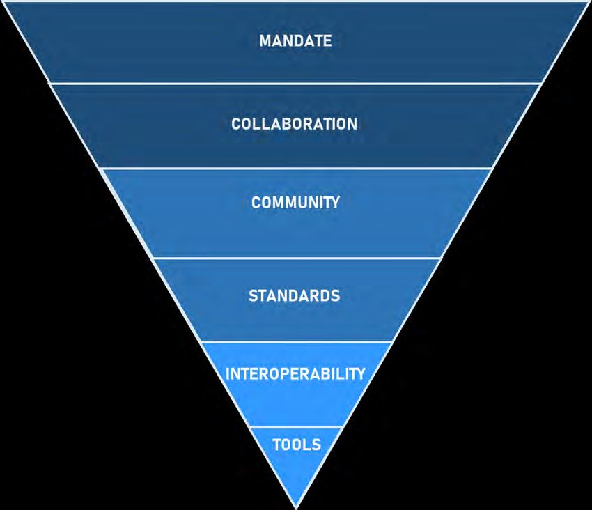
HOW OUR STRATEGY SUPPORTS A COMMON VIEW
Having common goals enables a collaborative approach to our key pieces of work over the next 5 years.
This diagram aims to show what role this strategy plays in a geospatial focussed landscape .
Governance to set vision,
and policy to enable actions
Formal partnerships
based on trust and shared need
Working relationships between
stakeholders to share best practice
Common guidelines that we adhere to, and
benefit all
Identified sources of truth,
data hosting, common terminology
and interfaces
Technology to effectively display
elements of a Common Operational Picture
Figure 2: The factors enabling a successful geospatial technology capability, and how this strategy addresses these
(adapted from Phyn, D., 2018).
THIS FRAMEWORK WILL ULTIMATELY SUPPORT INFORMED DECISION
MAKING ACROSS THESE CATEGORIES:*
HAZARDS RESPONSE SOCIAL BUILT
ENVIRONMENT ENVIRONMENT
LIFELINE RECOVERY ECONOMIC NATURAL
UTILITIES ENVIRONMENT ENVIRONMENT
*These categories were prioritised by internal stakeholder workshops held as part of this strategy development14 TEMO I GEOSPATIAL STRATEGY TO 2026
OUR ROAD MAP TO 2026
NOW YEAR ONE YEAR TWO
OBJECTIVES 2021/22 2022/23
Audit existing resources and skills Governance structure under CEG
DEVELOPING across the Taranaki region, and in established, including the creation of a
PEOPLE AND neighbouring regions to create a shared response technology portfolio. All
PROCESS knowledge, people and data register. processes documented. Staff members
Form an Innovation Working Group (IWG) on a geospatial training pathway. Skills
to deliver prototype response solutions learnt are then applied to begin to
self-servicing applications from the IWG.
Capture requirements and user Multiple geospatial-specific outreach
stories of external and internal users. and education initiatives underway.
UNDERSTANDING Review existing solutions in place across This allows knowledge of the group’s
ONGOING NEEDS OF New Zealand. Schedule a review of needs capability to be shared. Establishes a
USERS annually, and after each major response. forum to capture improvements from
both our own, and neighbouring civil
defence group stakeholders.
Our priority datasets are defined and a Coordination with majority of our
data improvement plan released stakeholders to provide interoperable data
ENABLING
defining these datasets. This includes sources as defined in our data
INTEROPERABLE
standards and polices for stakeholders improvement plan. Review existing
DATA
to deliver these. This local work aligns relationships to data providers and users,
with national work coordinated by and strengthen relationships between
NEMA. them.
Capture requirements and user stories Enhancing our existing response
of external and internal users. We will tools and capability. Initiate internal work
INVESTING IN review these annually, and after each developing our readiness capability, and
TECHNOLOGY major response. local sensitive information management
by IWG.
Figure 3: Strategy objectives roadmap showing categorised tasks by outcome workstream, and year.TEMO I GEOSPATIAL STRATEGY TO 2026 15
OUR ROAD MAP TO 2026
YEAR THREE YEAR FOUR YEAR FIVE
2023/24 2024/25 OUTCOMES
Resourcing and process has been Development of our processes to include
formalised for readiness & response. technical staff and users from cross CEG
Business case for a full-time members. WE ARE INNOVATING &
Geospatial Technician to focus on data
SUPPORTED BY SKILLED
At year-end, review progress of our staff, PERSONNEL
Integration tasks. Shared training
assess priorities and plan tasks for next
agreement across stakeholders.
strategic period.
Scheduled review of needs from Scheduled review of needs and
existing userbase. Establish new requirements from existing userbase.
WE HAVE
requirements gathering initiative New requirements gathering initiative
GEOSPATIAL USE
targeting our CEG advisory and targeting our community outreach
ACROSS OUR STAFF &
coordination group userbase userbase.
ACTIVITIES
At year end, review and plan with a focus
on our benefits realisation to our users.
Data integration project underway to Report on spatial data integrity against
deliver datasets unable to be our data improvement plan. Refresh our WE HAVE
delivered by stakeholder in spatial data inventory based on current COLLABORATIVE
required format, and enhance best practice INFORMATION
solution for the local storage of SHARING WITH ALL
At year-end, review and plan with the
sensitive datasets OUR STAKEHOLDERS
focus on our internal information and
intelligence outcome maturity
assessment .
Development of our geospatial Development of recovery capability by
reduction capability by IWG (in IWG (in addition to enhancing our
WE HAVE TOOLS FOR
addition to enhancing our existing existing capability).
DECISION-MAKER
capability). At year-end, review and plan with a fo- SITUATIONAL
cus on updating our geospatial roadmap. AWARENESS ACROSS
THE 4 R’S16 TEMO I GEOSPATIAL STRATEGY TO 2026
OUR OBJECTIVES
OBJECTIVE 1: DEVELOPING PEOPLE AND GOVERNANCE
Current and future geospatial staff need their roles identified and implemented. This will allow our technology investment to be used
to best effect This applies to our organisation too, including establishing roles and responsibilities backed by process to guide
our activities.
ID TASKS MEASURE DATE BY
1.1 Define the current state of geospatial An audit of existing systems and skills across the 2021/22
systems and skills across our CDEM Group region (and in neighbouring regions) to create a shared
Q3
knowledge, people and data register.
1.2 Formalise governance of the CDEM Groups Establish an Innovation Working Group to research and 2021/22
Geospatial Capability provide regular updates of significant technology
Q3
advancements and progress toward strategy
implementation
Establish a response technology governance structure 2022/23
that includes geospatial.
Q2
1.3 Plan for how GIS will be staffed, including A response technology portfolio position established, 2022/23
assigning roles and responsibilities the individual responsible will have oversight, and the
Q4
ability to report to CEG Partners on the implementation
of this strategy.
Our data improvement plan (Objective 3) used to 2023/24
identify staffing resourcing needed to perform any
Q1
integration and product development.
Table 1: Objective 1 Tasks, measures and timeframes.TEMO I GEOSPATIAL STRATEGY TO 2026 17
OUR OBJECTIVES
OBJECTIVE 2: UNDERSTAND THE ONGOING NEEDS OF USERS
Bringing stakeholders who will be using our geospatial information and tools across the 4 R’s along on our journey, and
understanding their needs allows targeted geospatial delivery. Delivering to these needs will promote stronger use and
relationships locally, and nationally.
ID TASKS MEASURE DATE BY
2.1 Engage with stakeholders to understand Capture initial requirements (gap analysis) and user 2021/22
their needs from geospatial on an ongoing stories of emergency management geospatial
Q2
basis information. User requirements are reviewed annually
and after each major response.
Produce a communications document that raises 2021/22
awareness of the role of GIS in emergency
Q3
management.
2.2 Holding workshops, exercises and debriefs A training pathway in geospatial software that grows 2022/23
to continuously improve where geospatial awareness and skills of staff and decision makers to
Q1
can meet information needs across 4 R’S begin to self-service, allowing time for specialists to
focus on design, templates and integration.
Hold six geospatial-specific outreach and education 2022/23
initiatives to build and share knowledge of the CDEM
Q4
group’s capability both internally and externally.
Table 2: Objective 2 Tasks, measures and timeframes.
.18 TEMO I GEOSPATIAL STRATEGY TO 2026
OUR OBJECTIVES
OBJECTIVE 3: ENABLING INTEROPERABLE DATA
We want the right information in the right format, in a timely manner. To do this requires identifying and reviewing sources of data
required. We must then work with stakeholders to provide these as interoperable data sources, and provide structure to ensure
sustainability of these services.
ID TASKS MEASURE DATE BY
3.1 Identify and prioritise information requirements Audit existing data and then define our datasets 2021/22
and products (see Appendix 3) that are highest
Q2
priority for the Taranaki CDEM Group and the
region (by classifying layers in our data and
service catalogue).
Provide a data improvement plan based on 2021/22
information and product needs defined by the
Q4
Taranaki CDEM Group and stakeholders
3.2 Identify and build relationships with key points of Technically enabled the ability to share geospatial 2022/23
contact through the Innovation Working Group to data with our neighbouring civil defence
Q1
provide interoperable data sources (see Appendix emergency management groups
1)
Have coordination with 80% of our public and 2022/23
private stakeholders to provided interoperable
Q2
data sources for our highest priority datasets (as
defined in our data improvement plan).
3.3 Set mandate, standards, privacy & security policies Defined our required standards and policies for 2021/22
and agree on common data schemas and stakeholder data, that align with those provided
Q4
terminology across our data providers by NEMA or the authoritative agency.
Table 3: Objective 3 Tasks, measures and timeframes.TEMO I GEOSPATIAL STRATEGY TO 2026 19
OUR OBJECTIVES
OBJECTIVE 4: INVESTING IN GEOSPATIAL TECHNOLOGY
We need to focus investment, time and effort to develop our geospatial technology platform. This will allow us to collect and
analyse information, from our stakeholders and share and disseminate it in a way that meets the needs of our users.
ID TASKS MEASURE DATE BY
4.1 Keep up to date with good practice within the Establish an advanced geospatial platform for 2022/23
emergency management community, with an response, building on existing good practice
Q1
initial focus on response tools across the New Zealand GIS in emergency
management community.
4.2 Plan, design and implement appropriate A business case prepared for annual budget 2021/22
technology to meet current needs and future allocation for the procurement, resourcing and
Q3
growth. (See Appendix 2b) development of geospatial technology.
4.3 Use GIS as an intelligence source across the 4 Report to CEG reviewing how GIS has been used Annually
R’s by creating applications to collect, analyse to assist with emergency management.
and disseminate information in a timely manner
Identified resourcing needed to provide data 2022/23
feeds from our data improvement plan
Q1
Identified gaps in current technology platform by 2022/23
documenting existing processes used for
Q2
geospatial use in emergency management locally
Table 4: Objective 4 Tasks, measures and timeframes.APPENDICES
TEMO I STRATEGY APPENDICES                                                                                       21

APPENDIX 1:
COORDINATING EXECUTIVE GROUP STATUS:
CURRENT GIS PLATFORM AND INFORMATION

 CEG MEMBER NAME                             GEOSPATIAL INFORMATION DATA THEMES                       SOFTWARE
                                              THEY MAINTAIN AND CAN CONTRIBUTE                          USED
 Taranaki Emergency Management Office                             Response                              Esri

 Taranaki Regional Council                        Hazards, Population, Natural Environment              Esri

 New Plymouth District Council                       Population, Building, Transportation,              Esri
                                                        Infrastructure and Economic

 Stratford District Council                          Population, Building, Transportation,              QGIS
                                                        Infrastructure and Economic

 South Taranaki District Council                     Population, Building, Transportation,              QGIS
                                                          Infrastructure, Economic

 Iwi Stakeholders                                                                                       Esri

 (Ngāti Tama/ Ngāti Mutunga/ Te Atiawa/         Response, Population, Economic and Natural
 Ngāti Maru/ Taranaki Iwi/ Ngāruahine/                        Environment
 Ngāti Ruanui/ Ngaa Rauru Kiitahi/
 Ngāti Maniapoto)

 New Zealand Police                                          Hazards, Response                          Esri

 Fire & Emergency New Zealand                                Hazards, Response                          Esri

 Taranaki District Health Board              Response, Population, Infrastructure and Economic          Esri

 St John Ambulance Service                                  Response, Population                        Esri

 Welfare Co-ordination Group                                                                           Unknown

 Lifelines Advisory Group

 Taranaki Seismic and Volcanic Advisory
 Group
                                           Hazards, Response, Population, Building, Transportation,
 Rural Advisory Group                         Infrastructure, Economic and Natural Environment

 Hazards Advisory Group

 Hazardous Substances Technical Liaison
 Committee

 Health Emergency Management Group

Table 5: Coordinating Executive Members, information sources they collect and current geospatial software in-use.
22 TEMO I STRATEGY APPENDICES APPENDIX 2A: CURRENT SITUATION - TECHNICAL TECHNICAL ENVIRONMENT SYSTEM CONTEXT TEMO’s current technical environment has limited collaboration and limited few real-time datasets from stakeholders. Figure 3: High-level system context diagram of stakeholder geospatial software environments (current state).
TEMO I STRATEGY APPENDICES                                                                                                      23

                                                                                              APPENDIX 2A:
                                                CURRENT SITUATION - STAFFING

TECHNICAL STAFFING RACI MATRIX
To resource current civil defence activities, most of the current technical roles are local government FTE’s coordinated when
required by TEMO.

                                  TEMO          NPDC            TRC             STDC           SDC
                                 Analyst       Analyst         Analyst         Analyst        Analyst

 Developing Strategy                A             A               A               A              A
 Data Management                    A            R/A              A               C              C
 Platform Administration            A             A                I               I             I
 Response Staffing                  A             A               A                I             I
 Procurement                        A             C                I               I             I
 Training Delivery                  A             C                I               I             I

 Table 6: Current areas of responsibility for civil defence geospatial use, and who is responsible.

 TABLE KEY
     R         Responsible
     A         Accountable

     C         Consulted

      I        Informed
24 TEMO I STRATEGY APPENDICES APPENDIX 2B: FUTURE SITUATION - TECHNICAL TECHNICAL ENVIRONMENT SYSTEM CONTEXT TEMO’s future technical environment will have multi-tier collaboration. This includes real-time datasets from stakeholders- achieved through integrating multiple instances of the same platform, or a data feed. Figure 4: High-level system context diagram of stakeholder geospatial software environments (future-state).
TEMO I STRATEGY APPENDICES                                                                                                        25

                                                                                                   APPENDIX 2B:
                                                       FUTURE SITUATION—STAFFING

TECHNICAL STAFFING RACI MATRIX
To resource the activities required as part of this strategy, most of the technical roles will be local    government FTE’s coordi-
nated by TEMO’s response technology portfolio lead.

                                       TEMO             NPDC           TRC          STDC          SDC           Other CEG
                                     Coordinator       Analyst        Analyst      Analyst       Analyst         Analysts

Strategy Implementation                    R               A             A             A            A               A
Stakeholder Relationships                  R               A             A             A            A               A
Solution Prototyping                       R               A             A             C            C               C
Data Improvement Plan Draft                R               C             C             C            C               C
Data Extraction                            R               A             A             A            A               A
Data Delivery                              R               A             A             A            A               A
Training Delivery                          R               C             C             C            C               C
Innovation Working Group                   R               A             A             A            A               A
Response Staffing                          R               A             A             A            A               A

Table 7: Future areas of responsibility for civil defence geospatial use, and who will be responsible.

TABLE KEY
      R         Responsible
      A         Accountable

      C         Consulted

       I        Informed
26 TEMO I STRATEGY APPENDICES
APPENDIX 3:
OUR END STATE—WHAT WILL OUR TOOLS DELIVER?
The outcome of the activities in this strategy will deliver decision support tools for all stakeholders across all phases of
disaster risk reduction. What this will look like can be seen in proposed future design that the Innovation Working Group
will coordinate to deliver in phases below:
Figure 5: High-level geospatial systems context diagram, based on current configuration.TEMO I STRATEGY APPENDICES 27
APPENDIX 3:
CONTINUED
Our approach of prioritising data, people and defined requirements, allows TEMO to be resilient and adapt to new
technologies when they become available. This allows our strategy outcomes to be met now and into the future.28 TEMO I STRATEGY GLOSSARY GLOSSARY CDEM Acronym for Civil Defence Emergency Management Groups. These groups provide regional coordination of reduction, readiness, response and recovery activities. CEG Acronym for Coordinating Executive Group. The Co-ordinating Executive Group (CEG) implements the decisions of the Civil Defence Emergency Management (CDEM) Group and is able to commit the resources of their representatives to the agreed work plan and projects (as consists of senior representatives of local authorities, and Civil Defence Emergency Management Group member organisations. GIS Acronym for Geographic Information Systems. These are systems designed to capture, store, manipulate, analyse, manage, and present all types of geographical data. Iwi Focal economic and political unit of Māori descent-and kinship-based hierarchy of: Waka (founding canoe) | Iwi (tribe) | Hapū (sub-tribe) | Whānau (family). LIFELINES Refers to Lifeline utilities. These are entities that provide essential infrastructure services to the community such as water, wastewater, transport, energy and telecommunications. NEMA Acronym for National Emergency Management Agency. NEMA is the Government lead for emergency management in Aotearoa New Zealand. RACI Acronym for Responsible, Accountable, Consulted or Informed. This is part of a tool called the RACI matrix which is a respon- sibility assignment chart. TEMO Acronym for Taranaki Emergency Management Office. TEMO is a shared service between all four councils in Taranaki who coordinate CDEM activities in the Taranaki region.
You can also read