Germany on the Way to 3D-Cadastre
←
→
Page content transcription
If your browser does not render page correctly, please read the page content below
Gruber/Riecken/Seifert, Germany on the Way to 3D-Cadastre                                           Fachbeitrag

          Germany on the Way to 3D-Cadastre
               Ulrich Gruber, Jens Riecken and Markus Seifert

Summary                                                         FIG-Working Week 2014 in Kuala Lumpur, Malaysia einge-
During the last years the information systems of national       reicht. Er beschreibt die aktuellen Entwicklungen in Deutsch-
mapping and cadastre were focusing demands for three-           land hinsichtlich der Integration der dritten Dimension im Lie-
dimensional applications, e. g. environment protection, plan-   genschaftskataster als Teil der AAA-Standardisierung. Für die
ning, energy supply and disaster management. The basic          zfv wurde er redaktionell überarbeitet.
request of coverage and actuality was defined for the third
dimension. In 2009, the Working Committee of the Surveying      Keywords: 3D-cadastre, solar and noise cadastre, CityGML,
Authorities of the States of the Federal Republic of Germany    vertical data integration
(AdV) came up with the following decision: “The collection,
data modelling and quality management of buildings for the
geo-topographical surveying and for the cadastre are main
tasks of the official German cadastre. This also includes the   1 Introduction
third dimension”.
This paper will focus on this process and will show benefits    In Germany property taxation was the reason for the
and applications.                                               establishment of the cadastre in the beginning of the
                                                                19th century. One hundred years later (1900) the property
Zusammenfassung                                                 cadastre was established. In the last decades the cadastre
Der vorliegende Beitrag wurde aus der Mitte des DVW-Ar-         was increasingly used for a lot of other mapping and
beitskreises 2 »Geoinformation« als deutscher Beitrag für die   planning issues – it became a so called multi-purpose

DOI 10.12902/zfv-0028-2014                                                                        139. Jg. 4/2014   zfv   223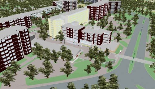
Fachbeitrag Gruber/Riecken/Seifert, Germany on the Way to 3D-Cadastre
cadastre as a geo-basis Land Information System (LIS) voltaic technology, geothermal energy, wind energy and
and nowadays as a part of the National Spatial Data In- the energetic isolation of buildings.
frastructure (NSDI). From the process view, data must be available to pro-
Nowadays economy, science and administration have vide actual information of the environment and all ener
an increasing demand for official three-dimensional spa- getically relevant topics (Fig. 1). Very often this leads to
tial information (3D‑geodata) as a base for multiple ap- a data collection or at least to a data processing task.
plications. The surveying and mapping administration in Having the required information, the analysis and the
Germany has accepted this demand as a challenge to de- evaluation will give a sustainable picture of the energy
velop and realise sustainable conceptions for 3D‑geodata, balance, including possible savings the use of renewals
focusing on fast and economic solutions. In this con- energies and energetic isolations of buildings.
text, national and international standards, infrastructures
and activities had to be considered. The German AAA®-
cadastre standard takes into account the international 2.2 Noise protection
standardisation of ISO and OGC to include 3D‑geodata.
The cadastre in Germany is a parcel-based system, i. e. The 3D‑geometry and semantics, particularly of build-
information is geographically referenced to unique, well- ings, are very important for simulating and mapping of
defined units of land. These units are defined by formal noise expansion. By a European Directive every five years
boundaries marking the extent of land. Each parcel is the member states of the European Union are obliged to
given a unique parcel-number. In addition the buildings
are collected and updated. Buildings are represented geo-
metrically (2D) and semantically. They are a basic compo-
nent of the cadastre and basis for tasks of the administra-
tion, economy and science. Because of the federalism in
Germany, the states and local authorities are responsible
for the cadastre. For that reason the AdV gives recom-
mendations for nationwide cadastral standardisation.
The AAA®-data model which ensures the interoperability
between cadastral and surveying and mapping data is the
result of this standardisation process.
2 The Demand for 3D-Building Information
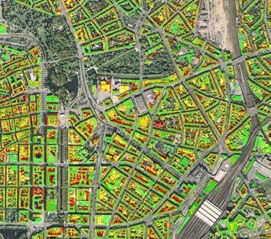
Fig. 2:
2.1 Energy turnaround Noise
map of
In Germany the government targets at climate and envi- the city
ronmental protection currently lead to extensive changes of Bonn.
in the energy sector, the so-called energy turnaround. Top:
This includes the end of the use of nuclear energy by for 24 h,
2020, the reduction of greenhouse gases and other ob- bottom:
jectives (BlmSchG 2012). As a result planning processes at night
especially have to take into account the use of photo
determine and to document noise pollution in cities. In
addition the progress of noise-reduction is checked. For
North-Rhine Westphalia the Ministry for Climate Pro-
tection, Environment, Agriculture, Nature Conservation
and Consumer Protection is providing a noise map in the
Fig. 1: internet (www.umgebungslaerm-kartierung.nrw.de, last
Photo visit 23.05.2014) (Fig. 2).
voltaic
map of
the city 2.3 Urban planning
of Dus-
seldorf The use of cadastral information for urban planning was
always essential in the 2D‑world, especially to consider
224 zfv 4/2014 139. Jg.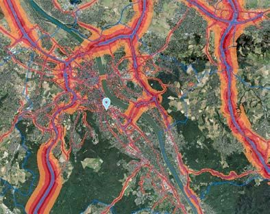
Gruber/Riecken/Seifert, Germany on the Way to 3D-Cadastre Fachbeitrag
Fig. 5: Real World, LoD1, LoD2
lack a proposal came up to expand the official cadastral
AAA®-data model towards the third dimension (Fig. 5).
Fig. 3: Planned school in the county of Recklinghausen
3.2 Approach
Several investigations have proved that only little addi-
tional information is needed to build up a 3D‑spatial data
set out of the existing 2D‑spacial cadastral data and to
keep the information up to date. What is needed are the
number of floors, ridge direction, and the building height.
Most of this information already exists in the planning
process; additional data is collected during the cadastral
survey. With this approach of data collection during the
survey a future 3D‑cadastre could be implemented sus-
tainable.
Fig. 4: Air rescue – county of Recklinghausen “Germany on the way to 3D‑cadastre” is a “topographic
approach” to extent the content of the cadastre. The de-
the property distribution. Nowadays 3D‑information is mand for taxation was the reason for the establishment
a basic demand of the urban planning sector (Fig. 3). of the cadastre in the beginning of the 19th century. One
Demographic effects and other restrictions could be visu- hundred years later the property cadastre was established.
alised in planning alternatives. In the last decades the cadastre was increasingly used for
other necessary mapping and planning issues – it became
2.4 Disaster management
Increasingly 3D‑information is used in the simulation of
disasters, for example for evacuation and flood scenarios
(Fig. 4).
3 Requirements for 3D-Building Information
3.1 Level of Detail (LoD) in the cadastre
While 3D‑building information in the LoD1-resolution
are sufficient for applications like noise mapping (2.2)
many other application like the aforementioned photo
voltaic map (2.1) at least need a higher LoD2 resolu-
tion (CityGML 2012). As a consequence so-called “city-
models” were built up in many cities in Germany. Their
basic goal was to support or even allow a visualisation
of special application scenarios (examples: 2.3, 2.4). On
the other side these models had not special quality or
updating mechanisms. Often they used the cadastre as a
data source (exact location / 2D building information), but Fig. 6: City model, Recklinghausen and 3D-spatial data,
they never became part of the cadastre. To overcome this Recklinghausen
139. Jg. 4/2014 zfv 225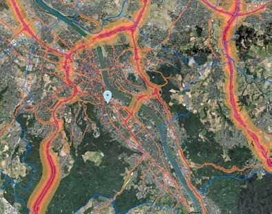
Fachbeitrag Gruber/Riecken/Seifert, Germany on the Way to 3D-Cadastre
a so-called multi-purpose cadastre, at that time restricted CityGML-Profil erstellt. Darin wurden die Klassen, Attri-
to 2D. With the AAA®-model modern technologies, XML- bute und Werte auf den zulässigen Umfang aus der Pro-
descriptions’ suitable software came up (Hawerk 2002) duktdefinition reduziert und abweichende Kardinalitäten
and today the link to CityGML takes place (Gröger et al. festgelegt.“).
2011). With this the 3D‑ability is included. The diagrams in Fig. 7 show that the AdV-profile uses
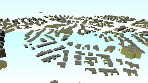
The pictures in Fig. 6 show the additional contents only parts of the CityGML-schema, especially mandatory
of a city model compared to 3D‑spatial data. While city requirements and quality indicators (Gerschwitz et al.
models often based on visualisation, the AAA®-3D‑spatial 2011). The profiles are logical restrictions to CityGML-
data are focusing on analysis. After the implementation schema.
of AAA®-3D‑spatial data, city models might be develop The updating process of the described interim solution
ed automatically as cadastral applications. will be done by reprocessing of the existing/original data.
An object-based actualisation does not exist yet.
AAA®-concept
4 Standards
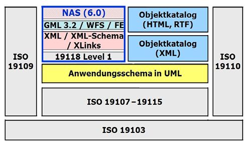
The AAA®-concept is national standard for official spa-
4.1 CityGML-Profiles and AAA®-3D-spatial data tial information in Germany. It was built up completely
by specialisation of international standards (AdV 2008)
The following step by step approach is applied to realise (Fig. 8). The AAA®-schema is a GML-application schema
nationwide 3D‑geodata set in Germany: which represents the national standard for geospatial
data of the surveying and cadastral administration in
Interim solution CityGML-Profiles Germany. The model and external schema are completely
embedded in existing standards of ISO and OGC.
Already today, there is a demand for 3D spatial informa-
tion. The currently used AAA®-data model (version 6) is
not able to store and to provide the expected 3D‑infor
mation. The expanded AAA®-version 7.0 will not be
available before 2018 all over Germany.
Fig. 8: AAA®-embedding existing international standards
(AdV 2008) (NAS = exchange interface, Objektkatolog =
feature catalogue, Anwendungsschema = application
schema)
According to size (number of citizens) Recklinghausen
Fig. 7: CityGML Version 1.0 and CityGML-Profile of AdV is the biggest county district in Germany and therefore
comparable to a city like Cologne. In 2011 about 1,600 ca-
Therefore the existing OGC standard CityGML (Grö dastral surveys took place with respect to buildings. For
ger et al. 2012) for the representation and exchange of Recklinghausen, as in general for the German cadastre
3D‑information is used. In March 2012, CityGML 2.0 with over 50 million buildings, it is therefore of funda-
was published as an international standard by the Open mental interest to store actual 3D‑building information
Geospatial Consortium (OGC). To realise the above-men- conform to the AAA®-standard and consistent to 2D- and
tioned interim solution profiles were created from GML 3D‑cadastral object information (in general: 2D‑property
and CityGML taking into account the needs of 3D spatial building layer identical to 3D building footprint) – the
information of the cadastral and surveying administra- so-called “vertical integration concept” (Fig. 9).
tion. As a result, the classes, attributes and values have This “vertical integration concept” takes into account
been reduced to the maximum extent permitted by the the source of the data and the production process. The
product definition (Gerschwitz et al. 2011: „Um die um- “legal” 2D‑property building layer as a major cadastral in-
fangreichen Freiheitsgrade von CityGML-Daten zu redu- formation is merged with the 3 dimension from laser scan
zieren und eine erste, durchgreifende Datenprüfung mit as a topographic source. The result is a “legal” 3D‑building
Schemavalidierungen durchführen zu können, wurde ein model.
226 zfv 4/2014 139. Jg.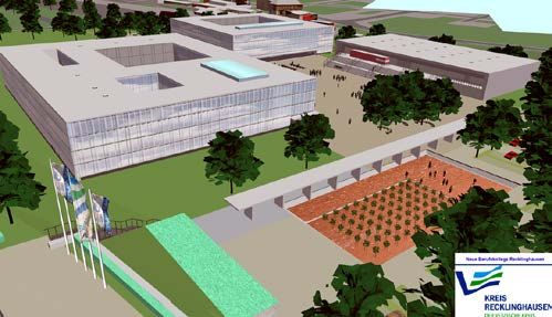
Gruber/Riecken/Seifert, Germany on the Way to 3D-Cadastre Fachbeitrag
The storage of quality information is an important part
in the German cadastre. Therefore information of quality
is modeled conform to ISO-19115-Metadata. Furthermore
the relevant modeling in the INSPIRE-building-topic
was considered, which also requires quality information,
especially the source of data. As a consequence it will
be possible to provide semantics match between the
AAA®-model and INSPIRE. This allows the realisation
of the exchange and conversion of data. The INSPIRE
Fig. 9: Vertical integration – Cadaster 2D and 3D data model, especially the profile extended3D, is one spe-
cial profile of CityGML, in a similar way to the AAA®-
It defines the AdV product “3D building model”. As a 3D‑expansion.
consequence, the demand, especially of the economy, for “The 3D‑building model of the AdV describes build-
official (administrative) 3D‑building information could ings in terms of the cadastral view as well as for topo-
be fulfilled. In addition this data participates in the exist- graphic surveying (LoD 1–3, chapter 2). It does not take
ing national and international spatial data infrastructure into account the modeling of interior rooms (LoD4), or
(SDI), for example through simple export to the defined city topography. The 3D‑building is an expansion of the
INSPIRE topics (Infrastructure for Spatial Information in “Hausumringe” (house foot prints) in the third dimen-
the European Community: European Directive, see http:// sion, accumulated with attributes of associated cadas-
inspire.jrc.ec.europa.eu). tral 2D‑objects. Currently the product standard describes
In contrast to CityGML, which is designed as an exter- building resolutions conform to LoD1 and LoD2 (Gru-
nal interchange format and for the easy use of 3D‑data, ber 2011: „Das 3D‑Gebäudemodell der AdV enthält aus-
the AAA®-concept defines a standard: application sche- schließlich Gebäude im Sinne des Liegenschaftskatasters
ma, feature catalogue and exchange interface. sowie wenige Bauwerke der topographischen Landesauf-
nahme im LoD 1–3. Sie umfassen z. B. keine Innenräume
(LoD 4), Geländeform oder Stadtmöbel. Das 3D‑Gebäude
4.2 Modeling aspects ist eine Erweiterung des Hausumrings um die dritte Di-
mension, angereichert mit Attributen des dazugehörigen
Basic schema 2D‑Objektes des Liegenschaftskatasters. Der Produktstan-
dard beschreibt derzeit 3D‑Gebäude/-Bauwerke in LoD1
The AAA®-schema is logically divided into several pack- und LoD2“).
ages, essentially into the thematic independent basic
schema and the thematic schema, which is based on the
basic schema. 3D‑classes, which are necessary, are inte- 5 Coverage, Availability
grated into AAA®-schema in three new packages:
p AAA_SpatialSchema 3D, 5.1 LoD1 und LoD2 in Germany
p AAA_Unabhaengige Geometrie 3D,
p AAA_Praesentationsobjekte 3D. Due to the constitutional responsibility of surveying and
mapping the responsibility for cadastral data is on the
The package “AAA_SpatialSchema 3D” contains addi- state level. As mentioned above the AdV defines nation-
tional information of the existing AAA®-schema in accor- wide cadastral standards. In addition a nationwide access
dance with the specifications for 3‑dimensional objects of point was established in North Rhine-Westphalia to dis-
the ISO-norm “191XX”. The package “AAA_Unabhaengige tribute about 21 million house coordinates (coordinates
Geometrie 3D” provides all necessary geometric shapes of buildings with an official address), about 50 million
(dot, line and surface) for the AAA®-3D‑schema objects 2D‑“Hausumringe” (house foot prints), and LoD1/LoD2-
with independent geometry. In the package “AAA_Prae data for Germany (Fig. 10) (for more information see
sentationsobjekte 3D” the modeling of presentation ob- AdV 2014).
jects is described.
Thematic schema
The AAA®-application schema defines object classes for
storing 3D‑information: The 2D‑classes “AX_Gebaeude”
and “AX_Bauteil” as well as the 3D‑class “AX_Bauteil3D”
have a common upper class “AX_Gebaeude_Kerndaten”.
The multiface possibilities of occurrence of geometry of Fig. 10: Data availability for North Rhine-Westphalia –
3D‑objects in “AU_Geometrie_3D” are limited by con- LoD1/2007 and LoD2/2014
straints.
139. Jg. 4/2014 zfv 227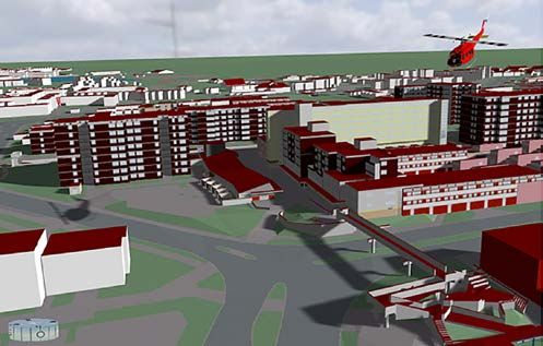
Fachbeitrag Gruber/Riecken/Seifert, Germany on the Way to 3D-Cadastre
AdV: Informationsmaterial zum Download (DE/E), Stand 2013 – www.
5.2 INSPIRE adv-online.de/Veroeffentlichungen/3D-Gebaeudemodelle-LoD, last
visit 22.05.2014.
INSPIRE is the central European Directive in the field of BImSchG: Law to protect against harmful effects of air pollution, noise,
vibration and similar phenomena, as amended by the 03.15.1974
spatial information and will speed up the harmonisation
26.9.2002, as last amended by Article 2 of G v. 06/27/2012 (Gesetz
of spatial information in Europe. With the AAA®-appli zum Schutz vor schädlichen Umwelteinwirkungen durch Luftver
cation schema, the AdV is already sufficiently prepared unreinigungen, Geräusche, Erschütterungen und ähnliche Vorgänge,
for the INSPIRE-compliant data submission (AdV 2008). vom 15.3.1974 i. d. F. vom 26.9.2002, zuletzt geändert durch Art. 2 G
v. 27.6.2012), 2012.
It was evaluated whether AAA®-instances could be pro-
Gerschwitz, A., Gruber, U., Schlüter, S.: Die dritte Dimension im ALKIS®.
vided for INSPIRE by applying a schema transformation. In: Kummer, K., Frankenberger, J. (Ed.): Das deutsche Vermessungs-
A demonstration client was developed and a mapping und Geoinformationswesen 2012. Wichmann Verlag, Berlin/Offen-
table was defined. It was proved, that the 3D‑AAA®- bach, p. 279–310, 2011.
Gröger, G., Kolbe, T. H., Nagel, C., Häfele, K.‑H. (Ed.): OGC City Geo
features can be transformed to INSPIRE-compliant in-
graphy Markup Language (CityGML), Encoding Standard, Ver-
stances without loss of information. sion 2.0, OGC Doc No. 12‑019, Open Geospatial Consortium, 2012.
Gruber, U.: Die dritte Dimension im amtlichen Vermessungswesen
Deutschlands. In: Löwner, M.‑O., Hillen, F., Wohlfahrt, R. (Ed.): Geo-
6 Conclusion informatics “Mobility and Environment” 2012. Proceedings of “Geo
information conference 2012” of 28.–30.03.2012, Braun schweig,
p. 303–309, 2012.
Economy, science and administration have an increasing Hawerk, Winfried: Cadastre 2020 – New Trends in Germany’s Cadas-
demand for official three-dimensional spatial informa- tre?!, FIG XXII International Congress, Washington, D. C. USA, April
19–26 2002.
tion (3D‑geodata) as a base for multiple applications. The
INSPIRE Thematic Working Group Building: D2.8.III.2 Data Specifica-
surveying and mapping administration in Germany has tion on Building – Draft Guidelines. Version 3.0rc3, 2012.
accepted this demand as a challenge to develop and rea Oestereich, Marco: Das 3D‑Gebäudemodell im Level of Detail 2 des Lan-
lise sustainable conceptions for 3D‑geodata, focusing on des NRW, NÖV 1/2014.
Riecken, J., Seifert, M.: Challenges for the multi purpose cadastre, FIG
quick and economic solutions. In this context, national
Working Week 2012.
and international standards, infrastructures and activities SIG 3D (2012): Quality concept: www.sig3d.org/index.php?catid=
had to be considered. The German AAA®-cadastre stan- 2&themaid=8777960, Last visit 23.05.2014.
dard takes into account the international standardisation
of ISO and OGC to include 3D‑geodata as an economic
solution for guidance and continuation. The approach of
the vertical integration of 3D‑geospatial into the cadas- Authors’ addresses
tral standard guarantees an interface to the German and Dipl.-Ing. Ulrich Gruber
DVW Working Group “Geoinformation”
European spatial data infrastructure. Especially consis-
County of Recklinghausen, Germany
tent regulation of modeling, actualisation concepts and ulrich.gruber@kreis-re.de
the quality management are activities which have to be
finished in the next years. Dr.-Ing. Jens Riecken
DVW Vice President
Cologne District Government, Germany
jens.riecken@dvw.de
References
AdV: Working Committee of the Surveying Authorities of the States of Dr.-Ing. Markus Seifert
the Federal Republic of Germany: GeoInfoDok (ALKIS®), main docu- DVW Working Group “Geoinformation”
ment Version 6.0, 2008. Bavarian Agency for Digitization, Fast Internet and Surveying,
AdV: Preliminary report “Digital Surface Models, architectural models” Germany
of the working groups “Geotopography” and “cadastre” for 120th markus.seifert@lvg.bayern.de
Committee sessions of the Working Committee of the Surveying Au-
thorities of the States of the Federal Republic of Germany on 10 to
11 September 2008, 2008.
AdV: Final minutes of the 121st Committee sessions of the Working
Committee of the Surveying Authorities of the States of the Federal
Republic of Germany of 9 to 10th September 2009. This article also is digitally available under www.geodaesie.info.
228 zfv 4/2014 139. Jg.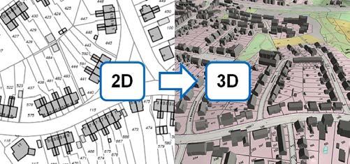
You can also read