GRADE 12 REVISED GEOGRAPHY - SECONDARY SCHOOL IMPROVEMENT PROGRAMME (SSIP) 2019
←
→
Page content transcription
If your browser does not render page correctly, please read the page content below
SECONDARY SCHOOL
   IMPROVEMENT
PROGRAMME (SSIP) 2019
       REVISED
    GEOGRAPHY
   REVISED ANSWERBOOK
      CLIMATOLOGY
      ANSWER BOOK

   GRADE 12
TABLE OF CONTENTS
SESSION TOPIC PAGE
1 MID-LATITUDE CYCLONE
2 TROPICAL CYCLONES
3 ANTICYCLONIC MOVEMENT OVER SA
4 MICROCLIMATE – VALLEY / URBAN
CLIMATE AND WEATHER ANSWERS
SESSION 1 - TOPIC 1: MID-LATITUDE CYCLONES
ANSWERS FOR SECTION B:
CAPS EXAM QUESTIONS ON MID-LATITUDE CYCLONES: CAPS QUESTIONS
Midlatitude cyclone
(November 2014)
Answers
1.1.
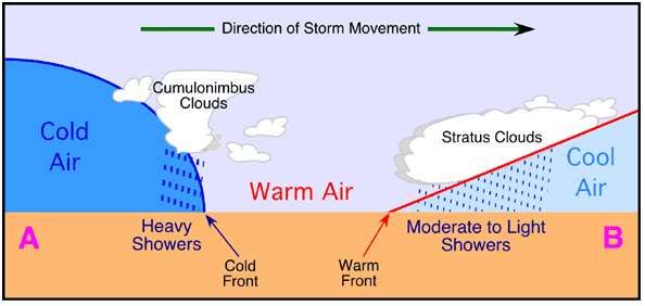
1.1.1 Cyclone family (1)Family of depressions (1)
1.1.2.(a)
showers
warm
air/sector
cold r shape of front
air/sector
[ANY FOUR] (4 x 1) (4)
(b) Decrease in temperature (2)
Change in the wind direction (backing) (2)
Heavy rainfall with thunder and lightning (2)
Increase in air pressure (2)
Increase in cloud cover (cumulonimbus clouds) (2)
Increase in wind speed (2)
Decrease in humidity (2)
Possibility of snowfall (2)
[ANY ONE] (1 x 2) (2)1.1.3. Weather conditions and reasons
Air temperature: 27°C (2)
Cold air descending from the high pressure warms adiabatically to create a
high temperature on the surface (2)
Dew point temperature: -12°C (2)
Dry area/winter therefore less evaporation (2)
Subsiding air reduces humidity (2)
Wind direction: NW/WNW (2)
Air diverging in an anticlockwise direction around the high pressure (2)
Wind speed: 5 knots (2)
Gentle pressure gradient (the isobars are far apart) (2)
Cloud cover: (1/8) (2)
Very little cloud cover as the area is dry and had low levels of moisture (2)
Subsiding air heats up and does not condense (2)
Low relative humidity (2)
Precipitation No precipitation (2)
Subsiding air does not condense
(2)
Limited cloud cover (2)
Large difference between air temperature and dew point temperature (2)
[ANY TWO WEATHER CONDITIONS AND REASONS] (4 x 2) (8)
2015 Feb
2.1
2.1.1. West to East/Eastwards/Easterly (1) (1 x 1) (1)
2.1.2 It has both a cold and a warm front that are well developed (2)
The warm sector of the cyclone is visible behind the warm front (2)
The cold sector of the cyclone is visible behind the cold front (2)
Isobars are circular around the apex (2)
The warm sector has a well-defined V shape (2) [ANY TWO]
2.1.3. The warm sector of air does not pass over South Africa (2)
The warm sector passes further south, over the ocean (2)
[ANY ONE] (1 x 2) (2)2.1.4. Occlusion process and associated weather
An occlusion occurs when a cold front catches up with a warm front at
the centre of the mid-latitude cyclone (2)
This is due to the cold front moving faster than the warm front as it is
cold and dense air (2)
This forces all warm sector air off the surface (2)
This results in cool and cold air masses behind the cold front and in
front of the warm front (2)
The coldest of these air masses forces the cool air to rise resulting in
light showers (2)
Thereafter the fronts collapse (2)
[ANY FOUR] (1 x 2) (8)
2015 June
3.1.1. Extratropical cyclone (1)
3.1.2. Southern (1)
3.1.3. Low (1)
3.1.4. Wave (1)
3.1.5. Easterly (1)
3.1.6. Winter (1)
3.1.7. 60° (1) (7 x 1) (7)
2015 Nov
4.1
4.1.1 Shape of front/convex (1)
Steep gradient of front (1)
Cloud – cumulonimbus (1)
Cold air behind the cold front (1)
[ANY ONE] (1 x 1) (1)
4.1.2. Cold air undercuts the warm air (2)
Warm air is forced to rise very high (2)
Large scale condensation takes place (2)
Steep gradient causes rapid/strong upliftment of air (2)
4
© Gauteng Department of Education[ANY ONE] (1 x 2) (2)
4.1.3 Cold air/drop in temperature behind the cold front (2)
Cold air heavy and dense thus increasing air pressure (2) (2 x 2) (4)
4.1.4. Air behind the cold front is colder than the air in front (2)
Cold air moves faster than warm
air (2) Cold front catches up with
the warm front (2)
Catches up at the apex, because it is the shortest distance between the
fronts (2)
Cold front undercuts the warm front (2)
Warm sector is lifted off the surface (2)
[ANY FOUR] (4 x 2) (8)
5.1. (2014 exemplar)
5.1.1. B (1)
5.1.2. A (1)
5.1.3. B (1)
5.1.4. B (1)
5.1.6. A (1)
5.1.7. A (1)
5.1.8. A (1) (8 x 1) (8)
5
© Gauteng Department of EducationANSWER FOR SECTION C: HOMEWORK QUESTIONS ON MID-LATITUDE
CYCLONES
QUESTION 1: 25 minute [30]
(Taken from NSC September Prep Exam 2013 Paper 1)
1.1.1. Mid-latitude Cyclone (1 x 1 = 1)
1.1.2. a. Northern hemisphere (1 x 2 = 2)
b. Air move anti-clockwise to the low pressure
Warm air is on the south of fronts and cold polar air is north of fronts.
(2 x 2 = 4)
1.1.3. a. Mature (1 x 1 = 1)
b. Larger cold sector than warm sector
Well-developed cold and warm fronts
Air pressure below 100hPa (2 x 2 = 4)
1.1.4. Temperature will drop
Wind will change direction (from West to North West) - backing
It will become cloudy and heavy shower will occur
Air pressure will first drop and then increase (3 x 2 = 6)
1.1.5. Positive: rain bring water for stock and crop farming
Improved yield and income
Negative: Cold conditions can cause stock losses
Cold conditions can cause damage to crops
Flooding lead to damage to crops & drowning of stock
Reduced income due to reduced yield (4 x 2 = 4)
1.1.6. Any (8 x 1 = 8)
Cross section through a mid-latitude cyclone
Cold Front section Warm front section
http://www.physicalgeography.net/fundamentals/7s.html
ONLY DRAW WHAT IS REQUIRED. If the question just refers to the cold front
only draw the cold front part of the sketch.
6
© Gauteng Department of EducationQUESTION 2: 25 minutes [30] (Taken from NSC Nov 2013 Paper 1) 2.1.1. Mid latitude cyclone. (1 x 2) (2) 2.1.2.
1.1.6. Mozambique is a poorer (less developed) country and has fewer
       resources to effectively deal with a tropical cyclone (2)
       Their early warning systems are not as effective as in developed
        countries
       Lack of media coverage to warn people, e.g. TV, radio and the
       Internet (2) Many people are not aware of dangers associated with a
       tropical cyclone (2)
       Mozambique's disaster management policies and techniques are
       not as sophisticated as those of developed countries (2)
       Mozambicans often build their houses from less weather resistant
       materials (2) Collapsing of poorly built houses cause more damage
       and loss of lives (2) Many people don't know what to do when a
       tropical cyclone hits (2) Many do not evacuate or leave their
       villages and homes in time (2)

       People are too poor to stock up on necessities for an emergency
       (2)
       Lack of emergency evacuation services (2)
       Poorly developed infrastructure makes it difficult for emergency
       services to reach people (2)
       Poorly equipped health services cannot provide medication to
       prevent outbreak of diseases (2)
       [Any FOUR. Accept other reasonable answers]                           (4 x 2)    (8)

2.1.   (2014 November)
       2.1.1 Cumulonimbus (Cb) (1)
       2.1.2. Eye/Eye of the storm (1)
       2.1.3. Low (1)
       2.1.4. From east to west/Westwards/Westerly direction (1)
       2.1.5. Heavy rainfall/Thunderstorms/Hail/Torrential rainfall (1)
       2.1.6. Subsiding/Descending/Sinking air movement/downwards (1)
       2.1.7. Diverging (1)
        2.1.8 Dissipating/Degenerating/Decaying/Dying out                      (8 x 1) (8)

                                                                                8
                        © Gauteng Department of Education
SYNOPTOC WEATHER CHART (20145 Feb)
3.1.1. Summer (1)
3.1.2
(1)
3.1.3. The very low air pressure at the centre of the cyclone (992 hPa) (2)
Very steep pressure gradient/4 isobars surrounding the area of low
pressure
are very close together (2)
The eye has developed(2)
[ANY ONE] (1 x 2) (2)
3.1.4. Calm, with no winds (2)
No rain (2)
No clouds (2)
Low pressure(2)
Ocean surface temperature of higher than 26,5°C (2)
[ANY TWO]
3.1.5. A tropical cyclone requires high levels of evaporation (2)
Latent heat to originate (2)
Convection currents of warm, moist, rising air can create
cumulonimbus
clouds (2)
(1 x 2)
[ANY ONE] (2)
3.1.6. Putting evacuation plans in place for getting people out of danger areas (2)
There must be rescue teams to rescue people from flooded areas (2)
A good forecasting system is essential to track and predict the path of
a tropical cyclone and to issue warnings (2)
Organisation of a first aid kit and batteries for radios, lamps and
torches (2)
Stock up on canned food and water supplies (2)
Place sand bags along rivers and coastal areas to reduce the impact
of flooding (2)
Erect wooden shutters on windows and educate people to stay away
from windows and doors during the storm (2)
(2 x 2)
[ANY TWO] (4)
9
© Gauteng Department of Education(2015 June)
4.1.1. From east to west (1)
Westwards (1)
Westerly (1)
[ANY ONE] (1 x 1) (1)
4.1.2 No tropical cyclone can form there; they require Coriolis Force to develop/
Only develop from 5º south (2) (1 x 2) (2)
4.1.3 11 days (2)
From 20/01 to 31/01 (2) (1 x 2) (2)
4.1.4. 2 600 km (2)
[ACCEPT BETWEEN 2 400 km AND 2 800 km]
[STRAIGHT LINE DISTANCE BETWEEN THE 20/1 and 31/1 IS NOT
ACCEPTABLE] (1 x 2) (2)
4.1.5. Differences in temperature (2)
Moisture content (2)
Friction over land (2)
Change in surface area (2)
[ANY TWO] (2 x 2) (4)
4.1.6. The ship will be delayed (2)
The ship will be forced to port at Beira or Maputo (2)
The ship may be forced to release some of its cargo in open waters
to reach the nearest port (2)
Could sustain damage from stronger waves (2)
Gale force winds will result in the ship being unable to maintain its course
(2)
Due to the severe weather the ship could lose its cargo/containers
can be washed overboard (2)
Emergency and rescue operations during the storm may force the
ship to be abandoned (2)
Containers can be washed
overboard (2) Shipwrecked (2)
The ship should sail within the path of the eye (2)
[ANY TWO - ACCEPT OTHER REASONABLE ANSWERS] (2 x 2)(4)
(2015 November)
5.1.1 Air circulates in an anti-clockwise direction (1)
Position of the dangerous semi-circle (1)
[ANY ONE] (1 x 1) (1)
5.1.2 Dangerous semi-circle (1)
Forward left hand quadrant (1)
North west quadrant (1)
10
© Gauteng Department of Education[ACCEPT OTHER CORRECT TERMINOLOGY] (1 x 1) (1)
5.1.3 Descending air does not condense it remains dry (2)
Adiabatic heating of descending air (2)
[ANY ONE] (1 x 2) (2)
5.1.4. Data can be received in real time (2)
Data can be monitored every hour (2)
Can help to determine the intensity trends of tropical
cyclones (2) Can be used to predict path based on
observed trends (2)
Images can be used to better determine other information such as speed,
temperature and wind direction (2)
Large and inaccessible areas can be monitored (2)
[ANY TWO] (2 x 2) (4)
5.1.5. ECONOMIC IMPACT
Damage to transport and communication
structures (2) Damage to personal
property/homelessness (2)
Businesses damaged (2)
Financial strain on people, families and businesses (2)
Insurance companies pay large amounts of
claims (2) Damage to vegetation, crops and
livestock (2) Damage to shipping, offshore
and coastal structures (2)
Costly to rebuild (2)
Negative influence on GDP (2)
Unemployment (2)
Creates opportunities for employment for
rebuilding (2) Impacts negatively on tourism
(2)
Affects trading of
goods (2) Food
insecurity (2)
Renewal of buildings and infrastructure (2)
ENVIRONMENTAL IMPACT
Flooding of low-lying coastal lands (2)
Coastal erosion (2)
Saline intrusion of low-lying coastal lands (2)
Waterborne disease such as
cholera (2) Ecosystems are
11
© Gauteng Department of Educationdisrupted (2)
Food chains and food webs are destroyed (2)
Silt is washed into dams reducing their water holding capacity (2)
Water table will rise (2)
[ANY FOUR. SHOULD REFER TO BOTH ECONOMIC AND
ENVIRONMENTAL IMPACTS. MAY REFER TO POSITIVE ASPECTS.
ACCEPT ANY OTHER RELEVANT ANSWERS] (4 x 2) (8)
ANSWER FOR SECTION C: HOMEWORK QUESTIONS ON TROPICAL
CYCLONES
QUESTION 1
1.1. 2 February (1 x 2) (2)
1.2. Sea surface temperatures of 27°C and above/extremely high temperatures (2)
Unstable atmospheric conditions/rising warm moist air (2)
Developed between 5° and 20° south of the equator (2)
Coriolis force is required for spiralling action of air (2)
Upper-air divergence (2)
High rate of evaporation/sufficient moisture content (2)
Release of latent heat (2)
Winds that are light and variable (2)
Calm conditions (2)
Little friction over the ocean (2)
Rapid convection (2) [Any TWO of the above] (2 x 2) (4)
1.3. The name Yasi starts with the letter Y - many cyclones prior to this (2)
25th cyclone (2)
Strong buildings to withstand tropical cyclones (2)
Path of the cyclone not obstructed by land masses, thus making Australia
more
vulnerable (2) [Any ONE of the above] (1 x 2) (2)
1.4. Category five is the most [candidates must emphasise most/worst/strongest]
destructive storm (2)
Extensive damage to property (2)
Extensive damage to infrastructure (2)
Loss of lives (2)
Damage to environment (2)
Farms destroyed (2)
Destructive winds/wind speed of over 200 km (2)
High wave swells (2)
Torrential rain (2)
12
© Gauteng Department of Education[Any TWO of the above. Give 2 marks for severity and 2 marks for example]
(2 x 2) (4)
1.5. (a) There was a raging storm and suddenly [candidates must emphasise
the quick/abrupt/sudden change] when the eye passes over (2)
It is calm (2)
Clear weather /no clouds (2)
No wind (2)
No rain (2) [Any TWO of the above] (2 x 2) (4)
(b) Subsiding/descending/sinking air causes stable conditions (2)
1.6. Very large sea swells due to the strong winds and intense low pressure in a
tropical cyclone – causes flooding of coastal areas with seawater (2)
(1 x 2) (2)
1.7. It is developed/an advanced country/MEDC (2)
Have a strong economy (2)
Occurs commonly there (2) [Any ONE of the above] (1 x 2) (2)
1.8. The cyclone developed over the Pacific ocean and are pushed form East to
west by the Tropical easterlies to hit Australia from the East. (2) (1 x 2) (2)
1.9. Moved in over land – friction slows winds down (2)
Less evaporation over land and further South (2)
dry stable air enters the system (2)
Air pressure rise (2)
Less condensation – less latent heat is released. (2) (4 x 2) (8)
QUESTION 2
2.1. Nine (1 x 2) (2)
2.2. Circular band of clouds (2)
Cyclone is named (2)
Large diameter of system (2)
Indicated as a tropical cyclone on satellite image (2)
The date (2)
The eye (2)
It is on north east coast of South Africa (2)
Clockwise rotation (2) (2 x 2) (4)
2.3. Figure 1: Mature stage
Figure 2: Dissipating stage (2 x 2) (4)
2.4. Eye – calm clear, windless cloudless (3 x 2) (6)
13
© Gauteng Department of Education2.5. Cumulonimbus/cb (2) (1 x 2) (2)
2.6. Forms between 5º and 25º N/S where the Coriolis force is strong enough to
promote the formation of the vortex (2)
Unstable atmospheric conditions necessary for convection and release of
latent heat (2)
Sea surface temperatures of 26.5° C or higher and over which promotes high
evaporation rates (2)
Several days of calm conditions are needed for the convergence of air (2)
Upper air divergence to maintain a low pressure on the surface and to
promote surface convergence (2)
Less friction over the sea (2) [ANY THREE] (3 x 2) (6)
2.7. Moved in over land – friction slows winds down (2)
Less evaporation over land and further South (2)
dry stable air enters the system (2)
Air pressure rise (2)
Less condensation – less latent heat is released. (2) (2 x 2) (4)
2.8. Unusual for KZN to be affected directly by tropical cyclones (2)
KZN is too far south/out of the 25ºS latitude (2)
Oceans are too cool (2)
Poorly constructed infrastructure & buildings will be affected (2)
Warning did not include evacuation procedures (2)
The area is underdeveloped (2)
Lack of communication for pre-warning (2)
Limited technologies as tropical cyclones are not common in this area (2)
Warning was for Monday and did not include Sunday (2)
Late summer (2) (2 x 2) (4)
2.9. IMPACT ON ENVIRONMENT
[ALSO ACCEPT HUMAN MADE ENVIRONMENT]
Loss of valuable topsoil (2)
Disruption of biodiversity (2)
Coastal wetlands are destroyed (2)
Food chains are disrupted (2)
Pesticides and insecticides used on farms are washed into rivers and dams
(2)
Destruction of aquatic systems (2)
Natural vegetation destroyed (2)
Flood water creates new streams/increases drainage density (2)
14
© Gauteng Department of EducationWaste material washed into oceans (2)
[ALSO ACCEPT POSITIVE IMPACTS]
IMPACT ON ECONOMY
Damage to infrastructure which is costly to repair (2)
Damage to beachfront properties which would negatively affect tourism and
the economy (2)
Loss of crops which leads to food shortages, higher prices and food imports
(2)
Loss of fertile soil leads to increase in production costs and rise in food prices
(2)
Less income generated by farms (2)
Loss of life (2)
Industries that depend on the primary sector for a supply of raw materials are
adversely/negatively affected and have to close temporarily (2)
Disruption to water and electricity supply due to damaged cables and burst
pipes (2)
Increase in health care costs due to outbreak of diseases (2)
Increase in insurance claims and cost as a result of storm damage (2)
Job losses (2) (4 x 2) (8)
SESSION 3 – TOPIC 3
15
© Gauteng Department of EducationSECTION B: ANSWERS ON TYPICAL EXAM QUESTIONS ON ANTI-CYCLONES
IN SA
Anticyclone and berg winds
(2014 November)
1.1 1.1.1 Kalahari High Pressure/Continental High Pressure (1) (1 x 1) (1)
(1 x 1)
1.1.2 Winter (1) (1)
1.1.3. The dominance of the (Kalahari/Continental) High Pressure over the
interior of the subcontinent, during winter (2)
A low pressure cell (coastal low/mid-latitude cyclone) along the southern or
eastern coast
Wind that moves down slope as a result of pressure gradient along the
escarpment (2)
[ANY TWO] (2 x 2) (4)
1.1.4. Air subsiding down the escarpment heats up at the DALR (2)
1°C temperature increases per 100 m of descent (2)
(1 x 2)
[ANY ONE] (2)
1.1.5. Clear skies at C are as a result of moisture evaporating when air warms up
adiabatically (through compression) (2)
16ºC/Large difference between air temperature and dew point
temperature, therefore air is dry (2)
Relative humidity is low (2)
Stable conditions are experienced due to subsiding air (2)
(1 x 2)
[ANY ONE] (2)
1.1.6. During Winter the vegetation is dry (2)
16
© Gauteng Department of EducationBerg winds are warm, dry winds (2)
Veld fires can easily be sparked (2)
Strong winds fan these fires (2)
[ANY TWO] (2 x 2) (4)
2.1 (2014 November)
.2.1.1 Air temperature INCREASES with an INCREASE in altitude (height) (1)
WARM air is found above the COLD air in the valley (1)
[CONCEPT] (1 x 1) (1)
(1 x 1)
2.1.2 Katabatic wind/Downslope wind/Gravity winds (1)
2.1.3. After sunset, the valley slopes cool down through terrestrial radiation
throughout
night (2)
Air in contact with the valley slopes cools down (2)
Cold air sinks under the influence of the force of gravity (2)
Cold heavy dense air will sink (2) (1 x 2) (2)
(1 x 2) (2)
[ANY ONE]
2.1.4. Cool air subsides to the valley floor (2)
Warm air that rises is cooled down to dew point temperature (2)
Air at the bottom of the valley condenses (2)
[ANY TWO] (2 x 2) (4)
2.1.5 Impact on farming:
Katabatic wind at night causes cold air to move down slope, causing a
frost pocket to develop in the valley (2)
Frost resistant crops are grown on the valley
floor (2) The cold conditions and FROST kill
pests (2)
Cold conditions suits the growing conditions of these crops (2)
The crops that are not frost resistant cannot be planted on the valley
floor/ die (2)
Acid rain can damage crops (2)
Impact on Settlements
Valley floor is cold and damp and therefore not suitable for settlement
17
© Gauteng Department of Educationdevelopment (2)
Smog (pollution) is trapped by the descending colder
air (2) This leads to respiratory problems (such as
asthma) (2) Visibility is reduced (2)
The rate of accidents
increase (2) Acid rain can
damage buildings (2)
[ANY FOUR. MUST REFER TO BOTH ASPECTS. CAN INCLUDE POSITIVE
ASPECTS. ACCEPT OTHER REASONABLE ANSWERS
3.1.
3.1.1. Clockwise (1)
3.1.2. Converges (1)
3.1.3. Lower (1)
3.1.4. Fog (1)
3.1.5. Lower (1)
3.1.6. A (1)
3.1.7. Q (1) (7 x1) (7)
(2015 February)
4.1.
4.1.1. A (1)
4.1.2. B (1)
4.1.3. A (1)
4.1.4. B (1)
4.1.5. B (1)
4.1.6. A (1)
18
© Gauteng Department of Education4.1.7. A (1) (7 x 1) (7)
5.1.
5.1.1. A zone between the warm moist air from the Indian Ocean and the cold dry
air from the Atlantic Ocean/A zone between two air masses with different
moisture content (1) (1x1)(1)
5.1.2. A – Warm, moist air – onshore flow from Indian (warmer) Ocean where
levels
of evaporation are higher (1)
B – Cold, less moist air – onshore flow from the Atlantic (colder) Ocean where
levels of evaporation are lower (1) (2 x 1) (2)
5.1.3. Line Thunderstorm/ Squall (2) (1 x 2) (2)
(1 x 2)
5.1.4. Eastern side (2) (2)
5.1.5. Warm, less dense and moist air comes from the northeast (A) (2)
Collides with cold, dry air mass from the
southwest (B) (2) Warm, moist air east of the
moisture front rises (2)
Condensation of warm, moist air east of the moisture front (2)
(2 X2) (4)
5.1.6. Hail (damage to crops) (2)
Lightning (start fires) (2)
Heavy rainfall (2)
Flooding (2)
Soil oversaturated (2)
[ANY TWO] (2 x 2) (4)
(2015 November)
6.1.1. A (South Atlantic High) (1)
6.1.2. B (Kalahari High) (1)
6.1.3. B (Kalahari High) (1)
6.1.4. A (South Atlantic High) (1)
6.1.5. B (Kalahari High) (1)
6.1.6. C (South Indian High) (1)
6.1.7. A (South Atlantic High) (1) (7)
(2015 November)
7.1.1. winter (1)
7.1.2. Kalahari (1)
7.1.3. coastal (1)
19
© Gauteng Department of Education7.1.4. eastwards (1)
7.1.5. offshore (1)
7.1.6. clear (1)
7.1.7. onshore (1)
7.1.8. increases (1) (8 x 1) (8)
SECTION C: ANSWERS ON HOMEWORK QUESTIONS ON ANTI-CYCLONES IN
SA
QUESTION 1: 30 minutes [32] (Adapted from NSC Trial 2013 Paper 1)
1.1. Subsides / sinks / descends
Rotate anti-clockwise in the Southern hemisphere
Diverge on the surface
1.2. Kalahari high pressure (1 x 1) (1)
1.3. Temperature inversion is a negative temperature lapse rate where warm
air occur above cold air (1 x 2) (2)
1.4. Air that rises – cools down (temperature drops)
Air that sinks / descends - heat up – (temperature increases)
(2 x 2) (4)
1.5. When temperature increases – relative humidly drops
When temperature decreases – relative humidity increases (2 x 2) (4)
1.6. a) winter (1 x 1) (1)
b) Subsiding air over interior – Kalahari HP is well-developed
Inversion lowers that escarpment
Moist maritime air cannot enter to the interior of SA (2 x 2) (4)
1.7. a. Frost (1 x 1) (1)
b. Fast radiation due to clear dry conditions during the night
Dew Point temperature drops to below 0ºC and frost forms
(2 x 2) (4)
1.8. Rainfall during summer as inversion occurs higher that the escarpment
and moist air flows into the interior
Little rainfall during winter as inversion occurs lower than the escarpment
and prevents moist air from flowing into the interior
Cloud cover during summer as warms moist air reaches the interior, rises
resulting in condensation
Little could cover during winter as warm moist air over interior is limited –
resulting in little condensation
Humidity increase in summer as moist air flows into the interior
Humidity decreases during winter as little moist air flows into the interior
20
© Gauteng Department of EducationHigher temperatures and smaller temperature ranges during summer
as cloud cover traps heat over interior
Lower temperatures and larger temperature ranges during winter as there
are no clouds and little water vapour to trap heat.
(ANY 4 x 2 = 8 but must refer to both winter and summer conditions)
(4 x 2) (8)
QUESTION 2:
2.1. Coastal LP (1 x 1) (1)
2.2. (must refer to how and why) (4 x 2) (8)
Describe how weather differs Explain why weather differs
DURBAN Onshore winds - moist air – Onshore winds - orographic lift, air
cloudy and rainy conditions cools and form clouds
Lots of moisture as warm
Mozambique current evaporates
easily
MAPUTO Offshore winds warm dry Offshore winds – dry air heats as it
conditions descends of the land
No evaporation over land to feed
moisture into air mass.
2.3. A: Kalahari HP
D: South Atlantic Ocean HP (2 x 2) (4)
2.4. A: > 1028 hPa (1029, 1030, 1031 hPa)
D: < 992 hPa (991, 990, 989 hPa) (2 x 2) (4)
2.5. Low temperatures over the interior
Kalahari HP is well-developed
MLC moves over the Country – far north
Anti-cyclones far north (2 x 1) (2)
2.6. E: Mid-latitude Cyclone (1 x 2) (2)
2.7. Describe the weather at Port Elizabeth by referring to the enlarged weather
station. (5 x 1) (5)
Temperature: 30ºC
Weather: Clear
Dew point temperature: 9ºC
Wind speed: 20 knots
Wind direction: WNW
Cloud cover: 1/8
2.8. Rapid drop in temperature (2)
Strong, gusty winds that backs (2)
Steep rise in air pressure (2)
Decrease in humidity (2)
Cloud formation (2)
Thunderstorms/heavy rain and hail (2) (2 x 2) (4)
21
© Gauteng Department of Education2.9. WHY PE IS EXPERIENCING UNUSUALLY HIGH TEMPERATURES:
BERGWINDS
Presence of a coastal low and Kalahari high (2) to result in berg wind conditions
(2)
As air descends down the escarpment it heats at the DALR (1°C/100m) (2)
Hot winds raise the temperature at Port Elizabeth (2)
IMPACT OF THE WARM WEATHER:
[ALSO ACCEPT POSITIVE IMPACT IF APPLICABLE]
Cause fires to spread rapidly (2)
Destroying valuable pastures, cultivated lands and forests (2)
Decreasing humidity levels which cause respiratory problems (2)
Livestock death due to unbearable temperature for animals (2)
Productivity decreases because workers become tired (2)
[ANY SIX] Accept other. Must refer to both aspects]
OR
WHY PE IS EXPERIENCING UNUSUALLY HIGH TEMPERATURES:
WARM SECTOR
Port Elizabeth is situated in the warm sector of the mid-latitude cyclone (2)
Temperatures raised by the warm sector (2)
IMPACT OF THE WARM WEATHER:
[ALSO ACCEPT POSITIVE IMPACT IF APPLICABLE]
Approaching cold front result in rising air and condensation (2)
Possible flooding could occur (2)
Destroying valuable pastures, cultivated lands and forests (2)
Livestock death due to unbearable temperature for animals (2)
Loss of income (2)
Destruction of infrastructure (2)
Costly reparations to be done (2)
Productivity decreases because workers become tired (2)
[ANY SIX] Accept other. Must refer to both aspects] (4 x 2) (8)
22
© Gauteng Department of EducationSESSION 4 – TOPIC 4
SECTION B: TYPICAL EXAM ANSWERS ON MICRO / LOCAL CLIMATE
City climate
Answers
2014 November
1.1. 1.1.1. Isotherms (1) (1 x 1) (1)
1.1.2. Warmer/ Higher in the CBD (2)
Cooler/ Lower in the rural area (2) Between 8ºC and 12ºC (2)
[ANY ONE] (1 x 2) (2)
1.1.3. Larger surface area that can be heated (2)
Heat trapped between buildings due to high building density (2)
Tall buildings prevents wind from removing heat out of the city (2)
Early in the morning/late afternoon sun`s rays hit buildings at 90° angle
concentrating heat on the buildings (2)
Material used to construct tall buildings absorb more heat (2) More heat is
trapped inside the buildings (2)
Air conditioning and lighting generate more heat (2)
[EMPHASIS ON TALL BUILDINGS]
[ANY ONE] (1 x 2) (2)
1.1.4. There is a cluster of high rise buildings away from the original CBD which
results in an irregular shape (2)
More vegetation in the surrounding rural area which lowers the temperatures
as you move away from the original CBD (2)
Isotherms follows the profile of the city (2)
[ANY TWO] (2 x 2) (4)
1.1.5. (a) Cities have less water bodies (dams/lakes/rivers etc.) (2)
Fewer plants/vegetation in urban areas thus less evapo-transpiration (2)
Water removed from cities by storm water drainage (2)
Artificial surfaces drain water out of cities (2)
23
© Gauteng Department of Education[ANY ONE] (1 x 2) (2)
(b) More heat in cities thus more convection which encourages the build-up of
precipitation (2)
More pollution in cities allows for more hygroscopic nuclei in cities (2) Higher
pressure in surrounding rural areas will result in convergence of air in CBD
with lower pressure (2)
Large scale upliftment of warm air results in convergence thunderstorms (2)
[ANY ONE] (1 x 2) (2)
(c) Wind speed and direction affected by layout and orientation of high-rise
buildings (2)
Buildings can channel prevailing winds in certain directions (2)
If indicated winds are stronger in the rural area, reasons must be given (2)
[ANY ONE] (1 x 2) (2)
2015 Feb
2.1. 2.1.1. The direction in which a slope faces/The angle at which the sun's rays
strike a slope (1)
[CONCEPT] (1 x 1) (1)
2.1.2 The north-facing facing slope is receiving the direct rays of sunlight, in the
Southern Hemisphere (1) (1 x 1) (1)
2.1.3 The area at A does not receive direct sunlight (2)
Area A is facing away from the sun's rays (2) High lying area casts a shadow
over slope A (2) [ANY ONE] (1 x 2) (2)
2.1.4 Air in contact with slopes heated (2)
Air becomes light/less dense (2)
Air rises along the slope (2) [ANY TWO] (2 x 2) (4)
24
© Gauteng Department of Education2.1.5 North-facing slopes in the southern hemisphere receive more sunlight
throughout the year(2)
Crops that require direct sunlight would be more well suited at area D (2)
Descending cold air forms frost pockets on the valley floor(2)
Crops that are sensitive to frost should not be planted in the frost pocket (C) (
Frost resistant crops to be planted at C (2)
Soils on the north-facing slope is also drier as a result of higher levels of
evaporation (2)
Farmers will have to irrigate the north-facing slope, to successfully plant crops
here (2)
The farmstead can be located on a higher slope as it is warmer/in the thermal
belt (2) [ANY FOUR] (4 x 2) (8)
2015 June
3.1.1 Katabatic/downslope/gravity (1) (1 x 1) (1)
3.1.2 Mountain slopes cool at night (2)
Winds in contact with the slopes cool down (2)
Lower temperatures increase the density of the air and it is forced to sink to
the valley floor (2) [ANY TWO] (2 x 2) (4)
3.1.3 As cold air sinks into the valley during night time it displaces the warm air
upwards (2) (1 x 2) (2)
3.1.4 WARM THERMAL BELT
Suitable for human habitation (2)
Creates stable warm weather conditions (2)
Reduces costs of heating households during cold winter night (2)
Suitable for the cultivation of crops that do not withstand frost (2)
VALLEY FLOOR
Plant frost resistant crops only (2)
Traps the cold air, fog and smoke (2)
Causes pollution problems in the valley (2)
[ANY FOUR - ACCEPT OTHER REASONABLE ANSWERS] (4 x 2) (8)
25
© Gauteng Department of Education2015 November
4.1.1 Anabatic/upslope wind (1) (1 x 1) (1)
4.1.2 1 occurs during the day while 2 occurs at night (2)
At 1 there is upslope movement of air while there is down slope movement of
air at 2 (2)
At 1 wind originates when slopes are heated and at 2 there is cooling of
slopes (2)
Density of air at 1 is low while density of air at 2 is high (2)
[ANY ONE DIFFERENCE] (1 x 2) (2)
4.1.3 Wind 2 (2)
Air moves down slope from high pressure to low pressure (2) (2 x 2) (4)
4.1.4 Cold air rolls into the valley and forms an inversion (trap pollutants) (2)
This forms smog (2)
Radiation fog/mist/haze also forms(2)
In winter more artificial heating also results in higher pollution levels (2)
[ACCEPT ANY TWO/THREE]
[Maximum of 6 marks for explanation] (4 X 2) (8)
5.1. Nov 2015
5.1.1 3,9 (1) (1 x 1) (1)
5.1.2 Urban heat island (1) (1 x 1) (1)
5.1.3 Heat is trapped by the buildings due to closely spaced building (2)
Reflective heat is transferred between the buildings (2)
Limited air flow to disperse of heat (2)
Heat that cannot escape is absorbed by building (2)
[ANY TWO] ANSWERS MUST RELATE TO BUILDING DENSITY AND NOT
BUILDING MATERIALS ACCEPT OTHER REASONABLE ANSWERS](2 x 2)
26
© Gauteng Department of Education5.1.4
27
© Gauteng Department of Education5.1.5 Planting more trees in the urban areas to absorb carbon dioxide (2)
Establishment of the roof gardens (2)
The use of white reflective paints or surfaces to prevent heat from being
absorbed (2)
Commercial decentralisation to move shoppers/workers to outlying areas (2)
Industrial decentralisation to prevent pollution in cities (2) Limit industrial
activities to daytime only (2)
Legislation to limit pollution (2)
Chimney stacks tall enough to release smoke above inversion layer (2)
Increase the number of water features (2)
Promote public transport to reduce the number of vehicles in the CBD (2)
Increase eco-friendly buildings (2)
[ANY TWO. ACCEPT OTHER REASONABLE ANSWERS] (2 x 2) (4)
28
© Gauteng Department of EducationSESSION 4 – TOPIC 4
SECTION C: HOMEWORK ANSWERS ON MICRO / LOCAL CLIMATE
QUESTION 1:
1.1. Area of higher temperatures over a city surrounded by lower rural
temperatures (2) [Concept] (1 x 2) (2)
1.2. High building density (2)
Urban activities e.g. industrial activities (2)
Artificial surfaces (2)
Geometric shape of surfaces (2)
Artificial heating (2)
Lack of vegetation (2)
Higher population (2)
Effective drainage system (2) [Any TWO] (2 x 2) (4)
1.3. Day - extends high above city (2)
Night - concentrated close over city (2) (2 x 2) (4)
1.4. High level of pollution from cars, factories, etc. (2)
Produce more condensation nuclei (2) (2 x 2) (4)
1.5. IMPACT OF HEAT ISLANDS ON PEOPLE
Smog and fog reduces visibility (2)
Increase in the incidence of accidents among motorists (2)
Heat stress may result in heart ailments (2)
More deaths amongst people living in cities (2)
The irritation of eyes (2)
Skin disorders (2)
The quality of life is lowered (2)
People suffer from respiratory diseases such as asthma (2)
High medical costs due to stress/diseases (2)
[Any Four] Accept other reasonable answers] (4 x 2) (8)
QUESTION 2:
2.1. Climate over a small area/local climate (2) [Concept] (1 x 2) (2)
2.2. Industries (2)
Pollution (2)
Urban development (2) [Any ONE] (1 x 2) (2)
2.3. Will receive the direct rays of the sun (2)
It will be warmer in winter (2)
There will be more light in the house which will reduce electricity consumption
(2) [Any ONE] (1 x 2) (2)
2.4 Anabatic winds/upslope winds (2)
They originate in valleys during the day when valley slopes are warm, the
warm air in contact with the slope rises (2) (2 x 2) (4)
29
© Gauteng Department of Education2.5. Air pollutants released by industries in the valley will be trapped by a thermal
belt/inversion layer (2)
Temperature inversion (2)
Cold air rolls down the valley slope at night, whilst warm air is forced to rise
and traps the pollutants (2) [Any TWO] (2X2) (4)
QUESTION 3:
3.1. 35ºC - 31ºC = 4°C (2) (1 x 2) (2)
3.2. Geometric shapes of buildings increases surface area for heating (2)
Building density traps heat (2)
Steel and concrete surfaces that absorb heat (2)
Multiple reflection of heat (2)
Heat generating activities e.g. cars, air conditioners (2)
Less plants/vegetation in city centre to reduce heat (2)
Pollutants above city trap/prevent heat from escaping (2)
Tall buildings prevent circulation (2)
Less evaporation because of fewer water surfaces (2)
[ALSO ACCEPT ANSWERS FROM OPPOSITE PERSPECTIVE: RURAL
AREAS/FARMLAND/FORESTS] [ANY TWO] (2 x 2) (4)
3.3. Heat island/heat dome/thermal dome (2) (1 x 2) (2)
3.4. Most pronounced/developed at night because air is subsiding (2)
High temperatures during the day lead to rising convection currents (2)
and therefore has a greater vertical dimension (2)
Colder air subsides at night time therefore lies lower at night (2)
Fewer urban activities (or examples of) at night time that releases heat over
the city centre therefore the pollution dome subside (2)
Inversion close to earth surface at night time (2) [Any TWO] (2 x 2) (4)
3.5 Heat released from urban areas/presence of rising convection currents (2)
Temperatures are high/35°C (2)
Vertical extent/height/ of pollution dome is higher than the tallest buildings (2)
[ANY ONE] (1 x 2) (2)
3.6. Greening of city – plant gardens and conserve greenbelts (2)
Improve the public transport system to reduce the number of cars (2)
Encourage lift clubs and the use of bicycles instead of cars (2)
Enforce strict regulations to reduce industrial emissions (2)
Introduce and encourage the use of hybrid and electric cars (2)
[Any Four] (4 x 2) (8)
30
© Gauteng Department of EducationQUESTION 4:
4.1.1 Katabatic (1)
4.1.2 Night (1)
4.1.3 Down slope (1)
4.1.4 Thermal belt (1)
4.1.5 Frost (1)
4.1.6. clear (1)
4.1.7. slopes (1)
4.1.8. Frost (1)
4.1.9. Radiation (1) (9 x 1) (9)
4.2. 4 marks for labels and 2 marks for sketch with arrows (6 x 1) (6)
DAY
31
© Gauteng Department of EducationYou can also read