GUIDED FEATURE MATCHING FOR MULTI-EPOCH HISTORICAL IMAGE BLOCKS POSE ESTIMATION
←
→
Page content transcription
If your browser does not render page correctly, please read the page content below
ISPRS Annals of the Photogrammetry, Remote Sensing and Spatial Information Sciences, Volume V-2-2020, 2020
                                                  XXIV ISPRS Congress (2020 edition)

    GUIDED FEATURE MATCHING FOR MULTI-EPOCH HISTORICAL IMAGE BLOCKS
                            POSE ESTIMATION

                                             Lulin Zhang1, ∗, Ewelina Rupnik1 , Marc Pierrot-Deseilligny1
    1
        LASTIG, Université Gustave Eiffel, ENSG, IGN, F-94160 Saint-Mandé, France - (Lulin.Zhang, Marc.Pierrot-Deseilligny)@ensg.eu,
                                                          Ewelina.Rupnik@ign.fr

                                                          Commission II, WG II/1

KEY WORDS: Feature matching, Analogue aerial images, Multi-epoch, Pose estimation

ABSTRACT:

Historical aerial imagery plays an important role in providing unique information about evolution of our landscapes. It possesses
many positive qualities such as high spatial resolution, stereoscopic configuration and short time interval. Self-calibration reamains
a main bottleneck for achieving the intrinsic value of historical imagery, as it involves certain underdeveloped research points such as
detecting inter-epoch tie-points. In this research, we present a novel algorithm to detecting inter-epoch tie-points in historical images
which do not rely on any auxiliary data. Using SIFT-detected keypoints we perform matching across epochs by interchangeably
estimating and imposing that points follow two mathematical models: at first a 2D spatial similarity, then a 3D spatial similarity.
We import GCPs to quantitatively evaluate our results with Digital Elevation Models (DEM) of differences (abbreviated as DoD)
in absolute reference frame, and compare the results of our method with other 2 methods that use either the traditional SIFT or
few virtual GCPs. The experiments show that far more correct inter-epoch tie-points can be extracted with our guided technique.
Qualitative and quantitative results are reported.

                        1. INTRODUCTION                                   DEM (Nurminen et al., 2015; Ellis et al., 2006; Fox, Czifer-
                                                                          szky, 2008), (iii) recent satellite images (Ellis et al., 2006; Ford,
Historical (i.e. analogue) aerial imagery plays an important              2013). In many scenarios none of the auxiliary data is at dis-
role in providing unique information about evolution of our               posal. When processing multi-epoch image blocks, ideally a
landscapes. The imagery had been acquired by many coun-                   joint self-calibrating bundle adjustment is carried out, includ-
tries all over the world and can be traced back to the begin-             ing inter-epoch image observations. However, extracting inter-
ning of 20th century (Cowley, Stichelbaut, 2012). In many                 epoch tie-points remains challenging because the scene changes
cases high spatial resolution stereoscopic acquisitions were per-         over time, and images are often of low radiometric quality vi-
formed (Giordano, Mallet, 2019), allowing for 3D restitution              olating the brightness constancy rule that all modern extraction
of territories. Coupled with high temporal sampling, the im-              algorithms rely upon.
agery becomes also suitable for long-term environmental stud-
ies. As of now, many historical images collections have been              In this work we propose a new approach to detecting inter-
digitized (Giordano, Mallet, 2019; USGS, 2019; IGN, 2019)                 epoch tie-points. Using SIFT-detected key-points we perform
and a number of attempts have been made to process the im-                matching across epochs by interchangeably estimating and
ages with the state-of-the-art automated methods developed in             imposing that points follow two mathematical models: at first
photogrammetry and computer vision community over the last                a 2D spatial similarity, then a 3D spatial similarity. We do
twenty years (Ayoub et al., 2009; Bakker, Lane, 2017; Chen,               not rely on any auxiliary data, making it a generic approach.
Tseng, 2016; Ellis et al., 2006; Feurer, Vinatier, 2018).                 We adopt GCPs only to quantitatively evaluate our results. In
                                                                          the following we briefly describe existing feature matching
Apart from imagery itself, sometimes corresponding metadata               methods, as well as recent approaches to georeferencing of
is archived too. For instance, camera focal length and phys-              historical images. In Section 3 we introduce our methodology,
ical size of the images are commonly found, whereas flight                and in Section 4 the experiments as well as results are given.
plans, camera calibration certificates or orientations are rarely         The terms features and tie-points are considered synonymous
available. Because the images were scanned, and prior to scan-            and used interchangeably throughout this publication.
ning they may have been kept in unsuitable conditions, a self-
calibration is always necessary.
                                                                                               2. RELATED WORK
Historical images are self-calibrated in a bundle block ad-
justment (BBA) routine, using tie-points and Ground Control
Points (GCPs) as input observations. When dealing with single-            2.1   Feature Extraction
epoch datasets, tie-points are efficiently recovered with modern
extraction algorithms, such as SIFT (Lowe, 2004), while GCPs              Feature extraction refers to finding discriminative structure in
originate from (i) field surveys (Micheletti et al., 2015; Walstra        images such as corner, blob, edge and so on, followed by a
et al., 2004; Cardenal et al., 2006), (ii) existing orthophotos and       matching step. According to whether machine learning tech-
                                                                          niques are applied, the image features can be categorized as
∗   Corresponding author                                                  hand-crafted or learned.

              This contribution has been peer-reviewed. The double-blind peer-review was conducted on the basis of the full paper.
                          https://doi.org/10.5194/isprs-annals-V-2-2020-127-2020 | © Authors 2020. CC BY 4.0 License.                      127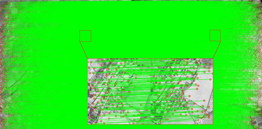
ISPRS Annals of the Photogrammetry, Remote Sensing and Spatial Information Sciences, Volume V-2-2020, 2020
                                             XXIV ISPRS Congress (2020 edition)

2.1.1 Hand-crafted Features In the early stage, Moravec               parameter transformation followed by a posteriori bundle block
detects corner feature by measuring the sum-of-squared-               adjustment must be carried out.
differences (SSD) by applying a small shift in a number of
directions to the patch around a candidate feature (Moravec,          Unlike in modern images where the image coordinate system
1980). Based on this, Harris computes an approximation to the         overlaps with the planimetric camera coordinate system, in his-
second derivative of the SSD with respect to the shift (Harris,       torical images the overlap is not maintained due to the scanning
Stephens, 1988). Since both Moravec and Harris are sensit-            procedure. To account for this, an additional 2D transformation
ive to changes in image scale, algorithms invariant to scale and      is estimated in the course of the processing (McGlone, 2013).
affine transformations based on Harris are presented (Mikola-         (Giordano et al., 2018) demonstrates the importance of the self-
jczyk, Schmid, 2004). Other than corner feature, SIFT (Scale-         calibration of historical images and its impact on 3D accuracy.
invariant feature transform) (Lowe, 2004) detects blob feature        Poorly modelled intrinsic parameters result in the known dome-
in scale-space, which is an entire pipeline including detection       like deformations that the authors eliminate with the help of
and description. It uses a difference-of-Gaussian function to         automatic GCPs from exiting orthophotos.
identify potential feature points that are invariant to scale and     Many cases reported in the literature calculate the image poses
orientation. SIFT is a milestone among hand-crafted features,         with SfM using features matched exclusively within the same
and comparable with machine learning alternatives. RootSIFT           epoch (Nurminen et al., 2015; Cardenal et al., 2006; Fox,
(Arandjelović, Zisserman, 2012) uses a square root (Hellinger)       Cziferszky, 2008; Walstra et al., 2004). In multi-epoch scen-
kernel instead of the standard Euclidean distance to measure          arios, the individual epochs should be defined in a common
the similarity between SIFT descriptors, which leads to a dra-        frame, be it the frame of a reference epoch or an absolute refer-
matic performance boost. Similar to SIFT, SURF (Bay et al.,           ence frame (i.e., a projection coordinate frame). Control points
2006) resorts to integral images and Haar filters to extract blob     derived from recent orthophotos and DEM (Nurminen et al.,
feature in a computationally efficient way. DAISY (Tola et al.,       2015; Ellis et al., 2006; Fox, Cziferszky, 2008) or GPS survey
2009) is a local image descriptor, which uses convolutions of         (Micheletti et al., 2015; Walstra et al., 2004; Cardenal et al.,
gradients in specific directions with several Gaussian filters to     2006) serve to transform the individual epochs to the common
make it very efficient to extract dense descriptors. KAZE (Al-        frame. Alternatively, a coarse flight plan may provide an ap-
cantarilla et al., 2012) is an algorithm that detects and describes   proximate co-registration (Giordano et al., 2018).
multi-scale 2D feature in nonlinear scale spaces. AKAZE (Al-
cantarilla et al., 2013) is an accelerated version based on KAZE.     To increase relative accuracy between several epochs,
                                                                      (Cardenal et al., 2006; Korpela, 2006; Micheletti et al., 2015)
2.1.2 Learned Features With the rise of machine learn-                manually insert inter-epoch tie-points. (Giordano et al., 2018)
ing, learned features have shown their feasibility in the image       extracts tie-points between analogue images and recent images
matching problem when enough ground truth data is available.          based on the method of (Aubry et al., 2014). (Feurer, Vinatier,
FAST (Rosten, Drummond, 2006) uses decision tree to speed             2018) joins multi-epoch images in a single SfM block based on
up the process of finding corner feature. LIFT (Learned In-           SIFT-like algorithm (Lowe, 2004; Semyonov, 2011) by making
variant Feature Transform) (Yi et al., 2016) is a deep network        the assumption that a sufficient number of feature points remain
architecture that implements a full pipeline including detection,     invariant across each time period. Identifying permanent points
orientation estimation and feature description. It is based on        over a long time-span has not reached a maturity and research
the previous work TILDE (Verdie et al., 2015), the method             in this domain remains insignificant. Most of the mentioned
of (Moo Yi et al., 2016) and DeepDesc (Simo-Serra et al.,             approaches rely on manual effort, auxiliary input or limiting
2015). SuperPoint (DeTone et al., 2018) is a self-supervised,         hypothesis.
fully-convolutional model that operates on full-sized images
and jointly computes pixel-level feature point locations and as-                         3. METHODOLOGY
sociated descriptors in one forward pass. LF-Net (Ono et al.,
2018) is a deep architecture that embeds the entire feature ex-       Figure 1 exhibits the workflow of our algorithm proposed in this
traction pipeline, and can be trained end-to-end with just a col-     paper. It can be divided as two main parts: processing intra-
lection of images. Finally, D2-Net (Dusmanu et al., 2019) is          epoch, and processing inter-epoch. The images are resampled
a single convolutional neural network that works as a feature         to the geometry of the fiducial marks prior to processing. For
detector and a dense feature descriptor simultaneously.               the sake of simplicity we only exhibit the processing flow of two
                                                                      epochs, however, it can be easily extended to more epochs. In
Even though the learned features demonstrate better perform-          the remaining of this section, both intra-epoch and inter-epoch
ance when compared to hand-crafted features on certain bench-         processing will be explained in detail.
mark, it does not necessarily imply a better performance in
terms of subsequent processing steps. For example, in the con-        3.1   Intra-epoch Processing
text of Structure from Motion (SfM), finding additional corres-       We process each single-epoch data individually as follow:
pondences for image pairs where SIFT already provides enough
matches does not necessarily results in more accurate or com-          1. Intra-epoch tie-points are effectively obtained by extract-
plete reconstructions (Schonberger et al., 2017).                         ing and matching feature points based on SIFT algorithm
                                                                          (Lowe, 2004);
2.2   Geo-referencing of Historical Images
                                                                       2. Interior and relative orientations are performed with
                                                                          standard SfM algorithm implemented in MicMac soft-
Pose estimation describes the intrinsic and extrinsic parameters          ware (Pierrot-Deseilligny et al., 2015);
of an image and is classically solved with the SfM algorithms
(Snavely et al., 2006; Pierrot-Deseilligny, Cléry, 2012; Schon-       3. Individual depth maps are obtained with semi-global dense
berger, Frahm, 2016). If the image pose should be known                   matching available in MicMac (Pierrot-Deseilligny, Papar-
in a reference coordinate system, i.e. be georeferenced, a 7-             oditis, 2006).

         This contribution has been peer-reviewed. The double-blind peer-review was conducted on the basis of the full paper.
                     https://doi.org/10.5194/isprs-annals-V-2-2020-127-2020 | © Authors 2020. CC BY 4.0 License.                   128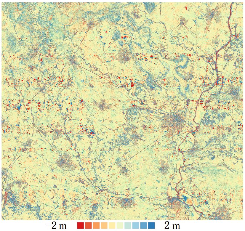
ISPRS Annals of the Photogrammetry, Remote Sensing and Spatial Information Sciences, Volume V-2-2020, 2020
                                                   XXIV ISPRS Congress (2020 edition)

Figure 1. Our processing workflow. The inputs are marked in yellow, the blue area corresponds to the inter-epoch processing, and the
gray is the intra-epoch processing. The input images had been resampled to the geometry of the fiducial marks prior to the processing.

3.2    Inter-epoch Processing                                                   Get final inter-epoch tie-points: in the preceding step we got
                                                                                rid of a substantial number of outliers, however, we believe not
Using images of all epochs, we now extract inter-epoch tie-                     all outliers could be identified. To obtain the final tie-points
points. We propose the following 3-step guided matching                         we introduce another filter, this time based on 3D similarity
strategy to increase the robustness of the automated tie-points:                transformation:
                                                                                                       P0 = λ · R · P + T                    (2)
Get tentative inter-epoch tie-points: extracted with SIFT
and matched based on mutual nearest neighbor (i.e., Euclidean                   Where the P0 are the 3D coordinates of a feature point in the
distance) between respective descriptors. To increase compu-                    reference frame of the intra-epoch reconstruction (e.g., epoch1 )
tational efficiency and discard noise, features are extracted on                and P are its respective coordinates in epoch2 . The 3D co-
images down-sampled with a factor of 1/6. No ratio test (Lowe,                  ordinates are retrieved from the individual depth maps com-
2004) was applied since very few tie-points were otherwise                      puted within the intra-epoch processing step. We now carry
retained. This obviously results in a higher number of false                    out the estimation of the scale λ, the translation vector T, and
matches but as these are only our tentative matches, we ac-                     the rotation matrix R in a RANSAC routine. We set the number
cept that. When choosing which feature extraction algorithm                     of RANSAC iterations to 1000, and consider tie-points within
to employ, we hesitated between SIFT as the state-of-the-art                    10m of its predicted position as inliers.
algorithm for hand-crafted features, and D2-Net – the state-of-
the-art in learned features. We chose SIFT based on a conduc-
ted experiment (see Section 4.3) where it outperformed D2-Net.                  3.3   Combined Processing
Get enhanced inter-epoch tie-points: out of the set of all
tentative matches we now want to identify and eliminate the
false matches. We introduce a 2D similarity transformation (cf.,                With the help of the 3D similarity transformation we can move
Equation 1) to describe the relation between feature points in                  our multi-epoch acquisitions to a common reference frame. Fi-
a pair of inter-epoch images. This assumption is satisfactory                   nally, we perform a BBA to refine all the camera poses and
for nadir images, which is our primary focus. The calcula-                      camera calibrations. The intra- and inter-epoch features are
tion is embedded in a RANSAC framework, and at each iter-                       the observations in our BBA. To analyze the results in a metric
ation the 2D similarity parameters (λ, θ, ∆x, ∆y ) are computed                 scale, the BBA is followed by another spatial similarity trans-
from minimal points in inter-epoch images. All points falling                   formation that brings the arbitrary reference frame tied to a se-
within N pixels from the prediction are considered inliers. In                  lected acquisition to a global reference frame. In our experi-
our experiment, N was set to 5% of the image diagonal, and                      ments, we derived this transformation thanks to several manu-
RANSAC iterations to 1000.                                                      ally identified points in a recent orthophoto and a digital surface
                                                                                model over the area. If precise poses for one of the epochs were
       0
      x                    cosθ   sinθ         x               ∆x               known, we fixed their parameters during the BBA and skipped
        0       =λ·                       ·            +                . (1)
      y                   −sinθ   cosθ         y               ∆y               the final spatial similarity transformation.

            This contribution has been peer-reviewed. The double-blind peer-review was conducted on the basis of the full paper.
                        https://doi.org/10.5194/isprs-annals-V-2-2020-127-2020 | © Authors 2020. CC BY 4.0 License.                            129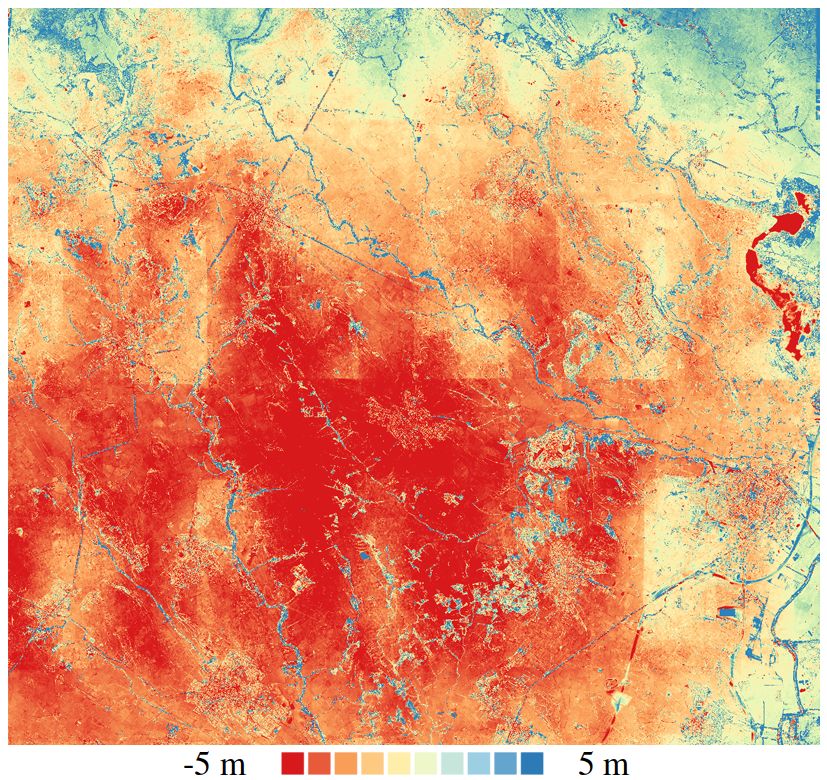
ISPRS Annals of the Photogrammetry, Remote Sensing and Spatial Information Sciences, Volume V-2-2020, 2020
XXIV ISPRS Congress (2020 edition)
4. EXPERIMENTS
4.1 Test Site and Data
The test site is a 420 km2 rectangular area located in Pezenas
in the Occitanie region in southern France. The area is mainly
covered with vegetation, and several sparsely populated urban
zones. We have at our disposal three sets of images acquired
in June 1971, in June 1981 and in 2015 (cf., Table 1). The
2015 images were acquired with the IGN’s digital metric cam-
era (Souchon et al., 2010). The area exhibited changes in scene
appearance due to land-use changes in the 44-year period. Our
ground truth (GT) is a reference 0.25m resolution DSM gener-
ated by the French Mapping Agency (IGN) in 2015.
epoch 1971 epoch 1981 epoch 2015 Figure 2. SIFT matching result on an inter-epoch image pair with
F [pix] 7589.06 7606.89 9967.5 9204.5 rotation and scale change.
Size [mm] 230,230 230,230 47,35 50,36
GSD [m] 0.32 0.59 0.46 0.50
F. o. 60% 60% 60% 60% To be able to compare the two feature extractors we removed
S. o. 20% 20% 50% 50% the scale difference and rotated one image to the orientation
H [m] 2400 4500 4600 4600 of the second image. The matching results are presented in
Nb 57 27 308 74 Figure 3. D2-Net detects and matches more points, however,
their precision is inferior to that of SIFT (see Figure 3 bottom).
Table 1. Details about 1971, 1981 and 2015 acquisitions. The
As mentioned in (Dusmanu et al., 2019), D2-Net is a detec-
2015 acquisition is obtained with two sets of camera. GSD is
tion based on higher-level information which inherently leads to
the ground sampling distance, F.o. and S.o. are forward and side more robust but less accurate keypoints. At the same time, D2-
overlap, H is the flying height, Nb is the number of images. Net features are also detected at lower resolution of the CNN
features (feature maps have a resolution of one fourth of the in-
put resolution). SIFT was the preferred algorithm because even
4.2 Evaluation Method though it finds few points, they are much more reliable than
D2-Net, and they are robust to image rotation.
As presented in Figure 1, we perform the BBA in a relative
coordinate system embedded in a selected epoch. Subsequently,
Inter epoch matching and BBA. In the BBA, all poses cor-
for evaluation purposes we transform the relative results to a
responding to 1971 and 1981 were considered as free paramet-
reference frame of our GT with the help of several manually
ers. Since the total number of intra-epoch tie-points is by far
measured GCPs. We evaluate the results by computing DSM
larger than the inter-epoch tie-points (cf. Table 2), we set the re-
differences (DoD), between the GT DSM and a DSM resulting
lative weight to balance the effect. We adopted the Fraser model
from our computations in respective years (cf. Figure 5). We
(Fraser, 1997) to calibrate the cameras, and allowed image-
compare Our method to two other approaches:
dependent affine parameters. The remaining parameters were
shared among all images. The poses of the 2015 acquisition
– SIF Tintra−inter : intra- and inter-epoch tie-points are ex- were accurately known a-priori thereby treated as fixed during
tracted and matched with SIFT; the combined BBA.
– SIF Tintra V GCPinter : intra-epoch tie-points are extrac-
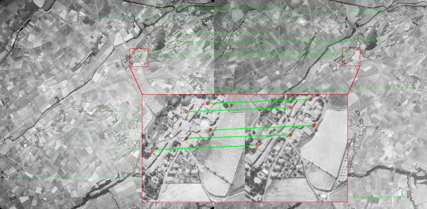
Comparison between three methods. Figure 4 illus-
ted with SIFT but no inter-epoch tie-points are present; the
trates the inter-epoch tie-points extracted with Ours and
individual epochs are co-registered with the help of virtual
SIF Tintra−inter between 1971 and 1981, 1971 and 2015 as
GCPs (i.e., points triangulated in one epoch and used as
well as 1981 and 2015. Our guided matching strategy de-
GCP in another).
tected far more points than the classical SIFT pipeline in
SIF Tintra−inter (cf. Table 2), especially for the most challen-
4.3 Result ging scenario (i.e. the one with the longest time gap between
1971 and 2015). Figure 5 shows the computed DoDs and
Comparison between D2-Net and SIFT. To decide which Table 3 reports the average and standard deviations computed
feature extracting algorithm to use in our guided matching, we on Z-coordinate difference. A dome artifact is present in
performed an experiment based on D2-Net and SIFT. D2-Net is DoDs corresponding to methods SIF Tintra V GCPinter and
employed with the off-the-shelf trained model provided by the SIF Tintra−inter . This kind of systematic error is known
authors, and we use their multiscale detection version to achieve to originate from poorly modelled camera internal parameters
better performance with scale changes. We always apply the (Giordano et al., 2018). In Ours, given the reasonable dense
ratio test for SIFT, and for D2-Net we test scenarios with and inter-epoch features and the calibrated 2015 acquisition, we are
without the ratio test. We used an inter-epoch image pair from able to effectively remove this discrepancy. Even though our
1971 and 1981. The images have a scale difference of factor proposed method performs best of all, we still observe some
1.8 and are rotated by 180◦ with respect to each other. D2-Net systematic errors, e.g. the stripe-like pattern that coincides
failed at finding corresponding features. This is probably due with the acquisition geometry, and the increasing differences
to its sensitivity to severe rotation. Meanwhile, SIFT correctly towards the edge of the image block in 1971, where few inter-
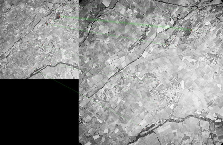
identified several matching points as shown in Figure 2. epoch tie-points were found.
This contribution has been peer-reviewed. The double-blind peer-review was conducted on the basis of the full paper.
https://doi.org/10.5194/isprs-annals-V-2-2020-127-2020 | © Authors 2020. CC BY 4.0 License. 130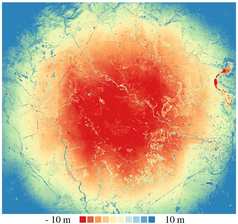
ISPRS Annals of the Photogrammetry, Remote Sensing and Spatial Information Sciences, Volume V-2-2020, 2020
                                             XXIV ISPRS Congress (2020 edition)

         (a) D2-Net without ratio test                   (b) D2-Net with ratio test                          (c) SIFT

     (d) Detail of D2-Net without ratio test         (e) Detail of D2-Net with ratio test                (f) Detail of SIFT

Figure 3. Matching result on inter-epoch image pair without scale change and rotation. Top: a global view, bottom: zoom over an area
with the images transformed to a common geometry. Notice the offsets between the D2-Net corresponding points.

       (a) Ours: epoch 1971 and 1981                 (b) Ours: epoch 1971 and 2015                (c) Ours: epoch 1981 and 2015

(d) SIF Tintra−inter : epoch 1971 and 1981     (e) SIF Tintra−inter : epoch 1971 and 2015   (f) SIF Tintra−inter : epoch 1981 and 2015

                                                    Figure 4. Inter-epoch tie-points.

         This contribution has been peer-reviewed. The double-blind peer-review was conducted on the basis of the full paper.
                     https://doi.org/10.5194/isprs-annals-V-2-2020-127-2020 | © Authors 2020. CC BY 4.0 License.                    131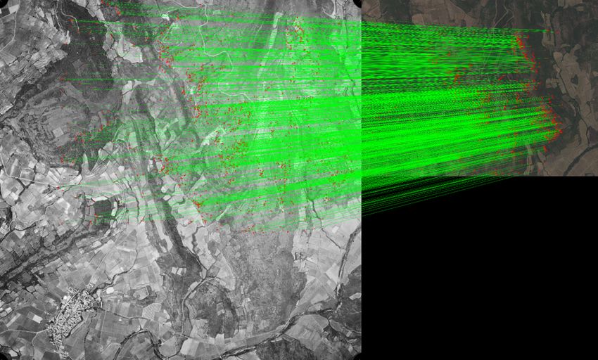
ISPRS Annals of the Photogrammetry, Remote Sensing and Spatial Information Sciences, Volume V-2-2020, 2020
                                            XXIV ISPRS Congress (2020 edition)

               (a) DoD2015                                (b) Orthophoto                   (c) Overlap of block 1971, 1981 and 2015

                                                             SIF Tintra−inter                           SIF Tintra V GCPinter
              (d) DoDOurs
                     1981                             (e) DoD1981                                (f) DoD1981

                                                             SIF Tintra−inter                           SIF Tintra V GCPinter
              (g) DoDOurs
                     1971                             (h) DoD1971                                (i) DoD1971

Figure 5. (a) DoD between GT DSM and 2015 DSM, (b) Orthophoto of the corresponding area, (c) Overlap of block 1971, 1981 and
2015, (d-f) DoD between GT DSM and 1981 DSM with Ours, SIF Tintra−inter and SIF Tintra V GCPinter , (g-i) DoD between GT
DSM and 1971 DSM with Ours, SIF Tintra−inter and SIF Tintra V GCPinter.

        This contribution has been peer-reviewed. The double-blind peer-review was conducted on the basis of the full paper.
                    https://doi.org/10.5194/isprs-annals-V-2-2020-127-2020 | © Authors 2020. CC BY 4.0 License.                       132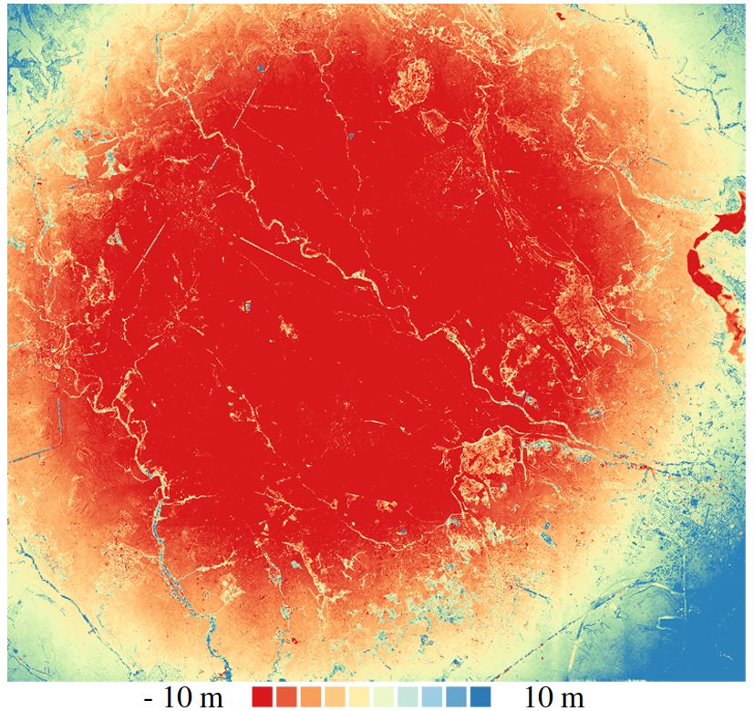
ISPRS Annals of the Photogrammetry, Remote Sensing and Spatial Information Sciences, Volume V-2-2020, 2020
                                              XXIV ISPRS Congress (2020 edition)

                    epoch 1971      epoch 1981      epoch 2015          Aubry, M., Russell, B. C., Sivic, J., 2014. Painting-to-3D model
   epoch 1971         448165          160031          28759             alignment via discriminative visual elements. ACM Transac-
                      448165           9075             341             tions on Graphics (ToG), 33(2), 1–14.
   epoch 1981            /            631290          61546
                         /            631290           2031             Ayoub, F., Leprince, S., Avouac, J.-P., 2009. Co-registration
   epoch 2015            /               /           18363596           and correlation of aerial photographs for ground deformation
                         /               /           18363596           measurements. ISPRS Journal of Photogrammetry and Remote
                                                                        Sensing, 64(6), 551–560.
Table 2. Number of extracted tie-points with Ours (in bold), and
with SIF Tintra−inter.                                                  Bakker, M., Lane, S. N., 2017. Archival photogrammetric ana-
                                                                        lysis of river–floodplain systems using Structure from Motion
                                    µ [m]     σ [m]     |µ| [m]
                                                                        (SfM) methods. Earth Surface Processes and Landforms, 42(8),
     DoD2015                         0.36      1.56      0.81
                                                                        1274–1286.
     DoDOurs
        1981                         1.10      2.36      1.45
        SIF T
     DoD1981 intra−inter            -1.10      3.45      2.94           Bay, H., Tuytelaars, T., Van Gool, L., 2006. Surf: Speeded up
     DoDSIF
        1981
            Tintra V GCPinter
                                    -1.53      8.00      6.98           robust features. European conference on computer vision, 404–
        Ours                                                            417.
     DoD1971                         0.45      2.75      1.61
        SIF T
     DoD1971 intra−inter            -7.55      7.67      9.62           Cardenal, J., Delgado, J., Mata, E., González, A., Olague, I.,
     DoDSIF
        1971
            Tintra V GCPinter
                                     0.30     15.36      12.51          2006. Use of historical flight for landslide monitoring. Proceed-
                                                                        ings of the Spatial Accuracy, 129–138.
Table 3. Average µ, standard deviation σ, and absolute average
|µ| of the Z-coordinate in the 7 DoDs in Figure 5.                      Chen, H., Tseng, Y., 2016. Study of automatic image rectific-
                                                                        ation and registration of scanned historical aerial photographs.
                       5. CONCLUSION                                    ISPRS - International Archives of the Photogrammetry, Remote
                                                                        Sensing and Spatial Information Sciences, XLI-B8, 1229-1236.
A new approach to detecting inter-epoch tie-points in historical
images has been proposed. Our validation datasets consisted             Cowley, D. C., Stichelbaut, B. B., 2012. Historic aerial photo-
of three epochs: 1971, 1981 and 2015. The proposed method               graphic archives for European archaeology. European Journal
outperformed the classical SIFT and D2-Net extraction al-               of Archaeology, 15(2), 217–236.
gorithms in detecting many more and reliable points. This
                                                                        DeTone, D., Malisiewicz, T., Rabinovich, A., 2018. Superpoint:
resulted in better pose estimation outcomes. The approach is
                                                                        Self-supervised interest point detection and description. Pro-
generic as no auxiliary data is required, and it is independent of
                                                                        ceedings of the IEEE Conference on Computer Vision and Pat-
limiting initial assumptions. We also performed an experiment
                                                                        tern Recognition Workshops, 224–236.
in which we show that (i) SIFT often provides less tie-points
than D2-Net but they are more precise; (ii) D2-Net is sensitive         Dusmanu, M., Rocco, I., Pajdla, T., Pollefeys, M., Sivic, J.,
to image rotation.                                                      Torii, A., Sattler, T., 2019. D2-Net: A Trainable CNN for Joint
Future work might concentrate on further improving robustness           Detection and Description of Local Features. arXiv preprint
of the proposed method, in order to handle more challenging             arXiv:1905.03561.
conditions, such as larger temporal gap. This could for example
be done by automatically searching for a more suitable scale            Ellis, E. C., Wang, H., Xiao, H. S., Peng, K., Liu, X. P., Li,
factor to downsample the input image to perform the tentative           S. C., Ouyang, H., Cheng, X., Yang, L. Z., 2006. Measuring
matching, or resorting to line features when necessary.                 long-term ecological changes in densely populated landscapes
                                                                        using current and historical high resolution imagery. Remote
                                                                        Sensing of Environment, 100(4), 457–473.
                  ACKNOWLEDGEMENTS                                      Feurer, D., Vinatier, F., 2018. Joining multi-epoch archival aer-
                                                                        ial images in a single SfM block allows 3-D change detection
This work was supported by ANR project DISRUPT (ANR-                    with almost exclusively image information. ISPRS journal of
18-CE31-0012-0). We thank Denis Feurer and Fabrice Vinatier             photogrammetry and remote sensing, 146, 495–506.
for their contribution to the interior calibration of the pezenas
dataset. We would also like to thank Sebastien Giordano for             Ford, M., 2013. Shoreline changes interpreted from multi-
the ground truth DSM and Benjamin Ferrand for the 2015                  temporal aerial photographs and high resolution satellite im-
acquisition.                                                            ages: Wotje Atoll, Marshall Islands. Remote Sensing of Envir-
                                                                        onment, 135, 130–140.
                                                                        Fox, A. J., Cziferszky, A., 2008. Unlocking the time capsule
                         REFERENCES                                     of historic aerial photography to measure changes in Antarctic
                                                                        Peninsula glaciers. The Photogrammetric Record, 23(121), 51–
Alcantarilla, P. F., Bartoli, A., Davison, A. J., 2012. Kaze fea-       68.
tures. European Conference on Computer Vision, 214–227.
                                                                        Fraser, C. S., 1997. Digital camera self-calibration. ISPRS
Alcantarilla, P. F., Nuevo, J., Bartoli, A., 2013. Fast explicit dif-   Journal of Photogrammetry and Remote sensing, 52(4), 149–
fusion for accelerated features in nonlinear scale spaces. British      159.
Machine Vision Conf. (BMVC).
                                                                        Giordano, S., Le Bris, A., Mallet, C., 2018. Toward automatic
Arandjelović, R., Zisserman, A., 2012. Three things everyone           georeferencing of archival aerial photogrammetric surveys. IS-
should know to improve object retrieval. 2012 IEEE Conference           PRS Annals of Photogrammetry, Remote Sensing and Spatial
on Computer Vision and Pattern Recognition, 2911–2918.                  Information Sciences, IV-2, 105-112.

         This contribution has been peer-reviewed. The double-blind peer-review was conducted on the basis of the full paper.
                     https://doi.org/10.5194/isprs-annals-V-2-2020-127-2020 | © Authors 2020. CC BY 4.0 License.                     133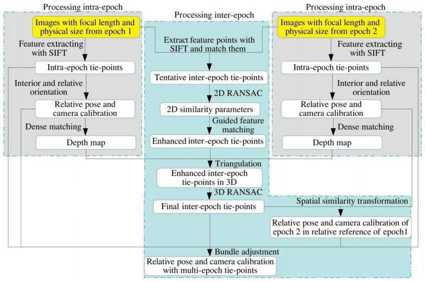
ISPRS Annals of the Photogrammetry, Remote Sensing and Spatial Information Sciences, Volume V-2-2020, 2020
                                             XXIV ISPRS Congress (2020 edition)

Giordano, S., Mallet, C., 2019. Archiving and geoprocessing of        Schonberger, J. L., Frahm, J.-M., 2016. Structure-from-motion
historical aerial images: current status in europe,official public-   revisited. Proceedings of the IEEE Conference on Computer
ation no 70. European Spatial Data Research.                          Vision and Pattern Recognition, 4104–4113.

Harris, C., Stephens, M., 1988. A combined corner and edge            Schonberger, J. L., Hardmeier, H., Sattler, T., Pollefeys, M.,
detector. In Proc. of Fourth Alvey Vision Conference, 147–151.        2017. Comparative evaluation of hand-crafted and learned local
                                                                      features. Proceedings of the IEEE Conference on Computer Vis-
IGN, 2019. remonterletemps. https://remonterletemps.ign.fr/.          ion and Pattern Recognition, 1482–1491.
Korpela, I., 2006. Geometrically accurate time series of              Semyonov, D., 2011. Algorithms used in photoscan. Agisoft
archived aerial images and airborne lidar data in a forest en-        PhotoScan Forum, 3.
vironment. Silva Fennica, 40(1), 109.
                                                                      Simo-Serra, E., Trulls, E., Ferraz, L., Kokkinos, I., Fua, P.,
Lowe, D. G., 2004. Distinctive image features from scale-             Moreno-Noguer, F., 2015. Discriminative learning of deep con-
invariant keypoints. International journal of computer vision,        volutional feature point descriptors. Proceedings of the IEEE
60(2), 91–110.                                                        International Conference on Computer Vision, 118–126.

McGlone, C., 2013. Manual of photogrammetry. American So-             Snavely, N., Seitz, S. M., Szeliski, R., 2006. Photo tourism:
ciety for Photogrammetry and Remote Sensing (ASPRS).                  exploring photo collections in 3d. ACM Siggraph 2006 Papers,
                                                                      835–846.
Micheletti, N., Lane, S. N., Chandler, J. H., 2015. Application
of archival aerial photogrammetry to quantify climate forcing         Souchon, J.-P., Thom, C., Meynard, C., Martin, O., Pierrot-
of alpine landscapes. The Photogrammetric Record, 30(150),            Deseilligny, M., 2010. The IGN CAMv2 System. The Photo-
143–165.                                                              grammetric Record, 25(132), 402–421.

Mikolajczyk, K., Schmid, C., 2004. Scale & affine invariant in-       Tola, E., Lepetit, V., Fua, P., 2009. Daisy: An efficient dense
terest point detectors. International journal of computer vision,     descriptor applied to wide-baseline stereo. IEEE transactions
60(1), 63–86.                                                         on pattern analysis and machine intelligence, 32(5), 815–830.

Moo Yi, K., Verdie, Y., Fua, P., Lepetit, V., 2016. Learning to       USGS, 2019. earthexplorer. https://earthexplorer.usgs.gov/.
assign orientations to feature points. Proceedings of the IEEE
                                                                      Verdie, Y., Yi, K., Fua, P., Lepetit, V., 2015. Tilde: a temporally
Conference on Computer Vision and Pattern Recognition, 107–
                                                                      invariant learned detector. Proceedings of the IEEE Conference
116.
                                                                      on Computer Vision and Pattern Recognition, 5279–5288.
Moravec, H., 1980. Obstacle avoidance and navigation in the           Walstra, J., Chandler, J., Dixon, N., Dijkstra, T., 2004. Time for
real world by a seeing robot rover. Technical Report CMU-RI-          change-quantifying landslide evolution using historical aerial
TR-80-03, Carnegie Mellon University, Pittsburgh, PA.                 photographs and modern photogrammetric methods. Interna-
Nurminen, K., Litkey, P., Honkavaara, E., Vastaranta, M.,             tional Archives of Photogrammetry, Remote Sensing and Spa-
Holopainen, M., Lyytikäinen-Saarenmaa, P., Kantola, T.,              tial Information Sciences, 35(B4).
Lyytikäinen, M., 2015. Automation aspects for the georefer-          Yi, K. M., Trulls, E., Lepetit, V., Fua, P., 2016. Lift: Learned
encing of photogrammetric aerial image archives in forested           invariant feature transform. European Conference on Computer
scenes. Remote Sensing, 7(2), 1565–1593.                              Vision, 467–483.
Ono, Y., Trulls, E., Fua, P., Yi, K. M., 2018. Lf-net: learn-
ing local features from images. Advances in Neural Information
Processing Systems, 6234–6244.

Pierrot-Deseilligny, M., Cléry, I., 2012. Apero, an open source
bundle adjusment software for automatic calibration and ori-
entation of set of images. ISPRS International Archives of the
Photogrammetry, Remote Sensing and Spatial Information Sci-
ences, XXXVIII-5/W16, 269–276.

Pierrot-Deseilligny, M., Paparoditis, N., 2006. A multiresolu-
tion and optimization-based image matching approach: An ap-
plication to surface reconstruction from SPOT5-HRS stereo im-
agery. Archives of Photogrammetry, Remote Sensing and Spa-
tial Information Sciences, 36(1/W41), 1–5.

Pierrot-Deseilligny, M., Rupnik, E., Girod, L., Belvaux, J.,
Maillet, G., Deveau, M., Choqueux, G., 2015. MicMac, Apero,
Pastis and Other Beverages in a Nutshell. MicMac documenta-
tion, 4.

Rosten, E., Drummond, T., 2006. Machine learning for high-
speed corner detection. European conference on computer vis-
ion, 430–443.

         This contribution has been peer-reviewed. The double-blind peer-review was conducted on the basis of the full paper.
                     https://doi.org/10.5194/isprs-annals-V-2-2020-127-2020 | © Authors 2020. CC BY 4.0 License.                     134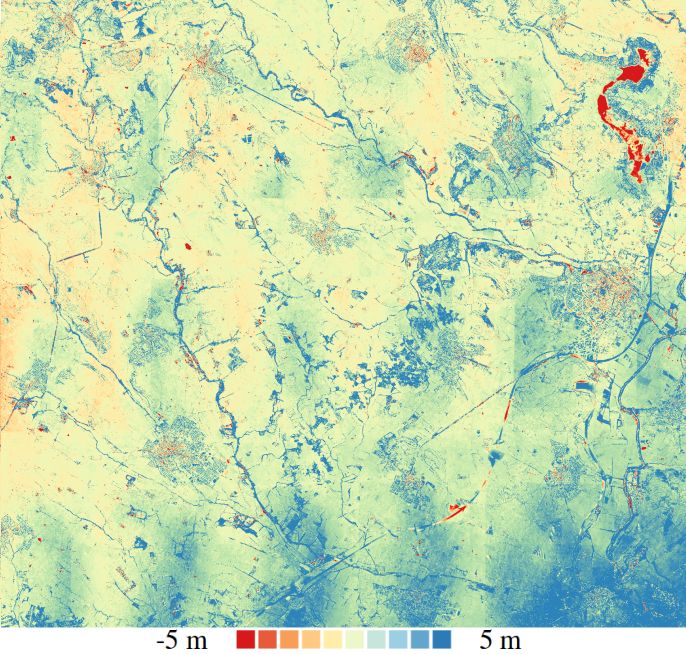
You can also read