Hermes - An Approach to Mass Transit Guidance with Mobile Devices - Stefan Christmann, Thorsten Caus and Svenja Hagenhoff Working Paper 01/2009
←
→
Page content transcription
If your browser does not render page correctly, please read the page content below
Working Paper 01/2009
Ed.: Matthias Schumann

Stefan Christmann, Thorsten Caus
and Svenja Hagenhoff

Hermes - An Approach to Mass Transit
Guidance with Mobile Devices

Arbeitsbericht
des Instituts für Wirtschaftsinformatik
Professur für Anwendungssysteme und E-Business
Georg-August-Universität Göttingen
Platz der Göttinger Sieben 5
37073 Göttingen

Working Paper
Institute of Information Systems
Chair of Application Systems and E-Business
University of Goettingen
Platz der Goettinger Sieben 5
37073 Goettingen, Germany

Tel. +49 (0) 551 / 39-4442
Fax +49 (0) 551 / 39-9735
www.as.wiwi.uni-goettingen.de
as@uni-goettingen.de

This work is licensed under the Creative Commons Attribution-Noncommercial-No Derivative Works 2.0 Germany License. To
view a copy of this license, visit http://creativecommons.org/licenses/by-nc-nd/2.0/de/ or send a letter to Creative Commons,
543 Howard Street, 5th Floor, San Francisco, California, 94105, USA.

Table of Contents                                                                                                                                            I

Table of Contents

Abstract ..................................................................................................................................................III

List of Figures ....................................................................................................................................... IV

List of Abbreviations............................................................................................................................. V

1 Introduction........................................................................................................................................6

2 Usage Situations and Motivation.....................................................................................................8

    2.1 Usage Situations..........................................................................................................................8

    2.2 Usage Motivations .....................................................................................................................10

3 Demands Towards a Mobile Personalized Mass Transit Guidance System .............................12

    3.1 Functional Requirements...........................................................................................................12

    3.2 Non-Functional Requirements ...................................................................................................13

4 Existing Solutions for Mass Transit Guidance.............................................................................14

    4.1 Conventional Approaches..........................................................................................................15

    4.2 Web-Based Approaches............................................................................................................15

    4.3 Mobile Applications....................................................................................................................16

5 Design of the Application ...............................................................................................................17

    5.1 Data Transmission.....................................................................................................................22

    5.2 Context Adaptation ....................................................................................................................24

    5.3 Usability .....................................................................................................................................27

    5.4 Security and Data Protection .....................................................................................................27

6 Implementation of the Application ................................................................................................28

    6.1 Client..........................................................................................................................................29

    6.2 Server ........................................................................................................................................33

7 Conclusions and Future Work .......................................................................................................34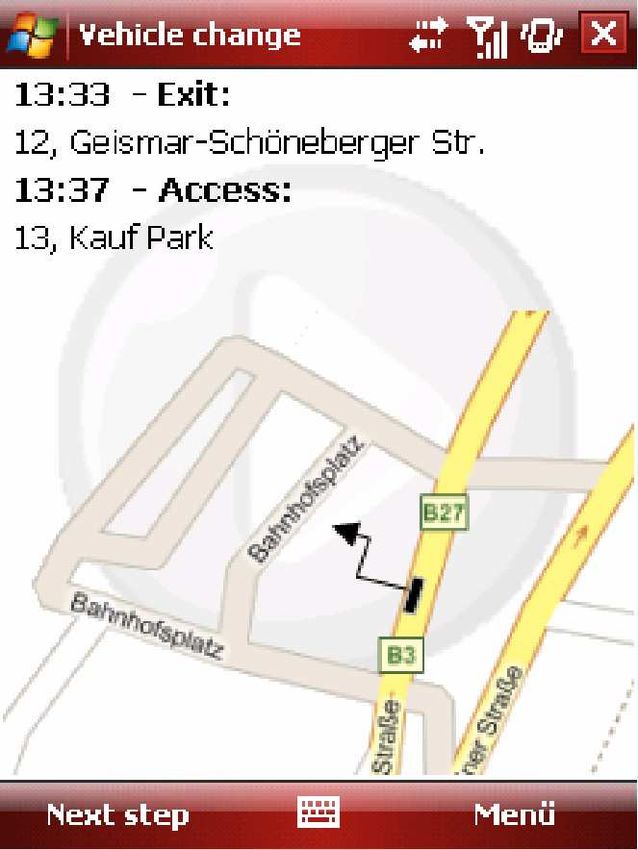
Inhaltsverzeichnis                                                                                                                                     II

References ............................................................................................................................................37

Abstract                                                                                                   III

Abstract

Mobility, understood as the possibility to move around, is an important part of human life. Sociologists
have even called mobility a vital principle for the individual and society. Mobility needs may be
satisfied in several ways: independently by motorized and non-motorized individual traffic, by means
of mass transit or by mixed forms like taxis or park and ride systems. In regard of the negative effects
of motorized individual traffic on the environment and the traffic situation in cities it is generally agreed
that mass transit ought to be strengthened. A main problem of mass transit systems is the complexity
of their usage. Time tables have to be found and understood, connections must be combined and
tickets purchased. This problem could be improved by using mobile end devices. This article presents
Hermes, a software to be installed on smartphones and PDAs that supports the user in all steps of
mass transit usage - from studying the time table to purchasing a ticket and footpath-navigation.
Hermes accompanies the user in a process-oriented way and automatically adapts to changing
environmental situations.
List of Figures                                                                                                                              IV

List of Figures

Figure 1: Sources for possible application situations .............................................................................. 8

Figure 2: Classification of mass transit guidance systems.................................................................... 14

Figure 3: Use case diagram .................................................................................................................. 17

Figure 4: Concatenation of sub-processes in mass transit guidance ................................................... 19

Figure 5: Content of a user profile......................................................................................................... 21

Figure 6: Component diagram............................................................................................................... 22

Figure 7: Excerpt from the XML-profile file............................................................................................ 23

Figure 8: Excerpt from the XML definition file ....................................................................................... 24

Figure 9: Adaptation of recommendations: personalization-rule-system of Hermes ............................ 26

Figure 10: Adaptation of the application: rule system for context-based action regulation................... 26

Figure 11: Screenshots of an exemplary mass transit usage (part 1) .................................................. 30

Figure 12: Screenshots of an exemplary mass transit usage (part 2) .................................................. 31

Figure 13: Screenshots of an exemplary mass transit usage (part 3) .................................................. 32

Figure 14: Screenshots of a mass transit usage interrupt..................................................................... 33

Figure 15: Login screen of server component....................................................................................... 34
List of Abbreviations                                                V

List of Abbreviations

API                     Application Programming Interface
CLDC                    Connected Limited Device Configuration
CSS                     Cascading Stylesheets
GPS                     Global Positioning System
HTTP                    HypterText Transfer Protocol
ISO                     International Standardization Organisation
J2EE                    Java 2 Enterprise Edition
J2ME                    Java 2 Mobile Edition
JSP                     Java Server Pages
JSR                     Java Specification Request
MDA                     Mobile Digital Assistant
MIDP                    Mobile Information Device Profile
NFC                     Near Field Communication
P3P                     Platform for Privacy Preferences
PC                      Personal Computer
PDA                     Personal Digital Assistant
PIM                     Personal Information Manager
PNG                     Portable Network Graphics
RMS                     Record Management System
RPC                     Remote Procedure Call
SMS                     Short Message System
SOAP                    Simple Object Access Protocol
SSL                     Secure Socket Layer
SVG                     Scalable Vector Graphics
W3C                     World Wide Web Consortium
WLAN                    Wireless Local Area Network
XHTML                   eXtensible Hypertext Markup Language
XML                     eXtensible Markup Language
1 Introduction                                                                                     6

1    Introduction

Without being aware of it, most people put distances behind them every day that add up to
many kilometers. We drive to work, to the supermarket, to the post office; we visit friends and
go to the cinema. Mobility, understood as the possibility to move around, is an important part
of our lives. The sociologist Opaschowski even sees mobility as a "vital principle for the
individual and society" [Opaschowski 1995]. In most cases mobility serves a purpose and is
only very seldom a purpose in itself.
Mobility needs may be satisfied in a number of ways: independently by motorized and non-
motorized individual means of transport, by mass transit using buses and trains or by mixed
forms like taxis or park and ride systems [Zemlin 2005]. Important as it may be for society,
transport always produces unwanted effects as well. The negative environmental effects of
motorized individual traffic and the traffic congestion in our cities are a steadily recurring issue
in politics and society. Usually there is a general agreement that mass transit needs to be
strengthened and motorized individual traffic must be cut back. In this context the non-users of
mass transit are an interesting phenomenon. They often underestimate the efficiency of this
mode of transport considerably and do not see how it can meet their mobility needs. At the
same time, however, they favor more restrictions for individual transport and prefer mass
transit in conflict situations [Brög 1990]. Their judgment refers "rather to the value system of
communal benefit than to the system of optimized individual benefit" [Brög 1990].
The question is why traffic users favor mass transit in principle while at the same time they do
not actually use it. Explanations referring to "life style", misjudgment and means of transport
as status symbols are not fully satisfactory. A main problem of mass transit is the complexity
of its usage. Time tables have to be found and comprehended, connections combined and
tickets purchased. This is usually not a problem in planned movements like the routine trip to
work, but unplanned movements often pose problems. The complexity of mass transit
systems combined with a lack of information on the side of the user often leads to using
individual means of transport when the need for movement arises spontaneously. Existing
solutions to this problem are customer information systems available in buses, at stations and,
since more recent years, in data communication networks like the Internet.
Information technologies may be able to provide a better solution, as the miniaturization and
growing efficiency of computers makes it possible for almost everybody to carry one with them
every day: mobile telephones can do much more than provide communication services over
long distances. A great number of mobile phones allow for the installation of additional
applications which facilitate access to the local data of the user and are able to access
1 Introduction                                                                                  7

additional information via the mobile network. Provided the present geographical position of
the device can also be identified, an application becomes imaginable that serves the user as a
personal assistant and guide in his travel plans. Mass transit companies could provide such
applications for their customers in order to increase the usage of their transport systems.
Additional functions like the automatic purchase of tickets or the recommendation of
restaurants and entertainment facilities are imaginable. In order to make such systems really
usable, the limitations of mobile end devices must be reckoned with.
Hermes was developed and implemented as a prototype to look into the feasibility of such
applications. The application registers the current context of the user and his personal
preferences in order to minimize data entries by the user. It is named after Hermes (Έρµής in
Greek, meaning a pile of marking stones) who, according to Greek mythology, is the
messenger of the gods as well as the protector of roads, traffic and ramblers [Burkert 1985].
The article has the following structure: chapter 2 looks at two possible usage situations and
usage motivations for a mobile application for local transport guidance. Then the requirements
towards the application are defined. Methods of competing mass transit guidance systems are
considered and assessed on this background. Chapter 5 builds on these considerations and
deals with the concept of the application from a technical point of view; chapter 6 describes its
implementation in a pilot project. The article closes with a résumé in chapter 7, summarizing
the results and providing future prospects.
2 Usage Situations and Motivation                                                                 8

2     Usage Situations and Motivation

In order to provide a clearer idea of the operational areas of mobile applications for
personalized mass transit guidance systems, the following chapters provide a description of
possible usage situations and reasons for the use of such an application.

2.1       Usage Situations

Computer-based personalized mass transit guidance systems have a multitude of possible
application situations. When a mobility need (a) exists, a person (b) uses a transportation
system (c) to reach a certain destination at a certain time, both defined by the mobility need.

                       Mobility need                Person       Transportation system
                  (1) new              (3) error               (5) exception
                  (2) changed          (4) insufficient        (6) unusable
                                            knowledge              vehicle

                                       Possible application situations
                                for personalized public transport guidance

                           Figure 1: Sources for possible application situations

These three components (cf. Figure 1) are sources for the need to use a personalized mass
transit guidance system, as the following description of six possible usage scenarios shows:
The mobility need can change (a; situation 1 and 2), errors or shortcomings of the user (b;
situation 3 and 4) can exist, or exceptions inside or in connection with the transportation
system can occur (c; situation 5 and 6).

      •    Situation 1: new mobility need

           Due to a spontaneously arranged meeting, a café has to be reached. The application
           identifies the best mass transit connection, guides the user to the nearest station or
           bus-stop, provides information on the station of exit and guides him from there to the
           final destination. Personal preferences and characteristics of the user are taken into
           consideration when establishing the connections. Should he be a member of a car-
2 Usage Situations and Motivation 9
sharing company, for example, the usage of this service would be one of the possible
options offered by the application.
• Situation 2: changed mobility need
While using mass transit, the next appointment is postponed or cancelled. The
application provides a changed travel route and opportunities for entertainment or
activities adapted to the user at the present location or at the destination.
• Situation 3: user-based exception
On his way to work, the mass transit user misses a connection. At once the application
identifies alternative connections as well as a footpath that could be used provided the
user considers it acceptable; additionally, it offers an automatic taxi call. The taxi can
be paid using the integrated pay function. The application can also calculate the new
time of arrival and communicate it, for example by SMS, to a contact person.
• Situation 4: movement on unknown territory
On a business trip to a big city the user feels insecure because the town is unknown to
him and there is a great variety of means of transport. He lets himself be completely
guided through the unknown system of traffic lines, tariff systems and stations by the
application, including guidance when changing at main traffic junctions or changing
from one means of transport to another.
• Situation 5: unusable vehicle
Due to extremely bad weather conditions or a defective vehicle, the daily way to work
cannot be covered by car or bicycle. The planned movement has to be done by mass
transit instead. The application guides the user to his workplace and purchases one or
several adequate tickets which are presented to the ticket collector as bar codes. If the
user is eligible for fare reductions or has a season ticket, this will be taken into account
when purchasing the tickets.
• Situation 6: exception in transportation system
During breakfast the application checks the planned route. The evaluation of the
information shows that the scheduled bus will be seven minutes late due to road works
so there is still time for another cup of coffee.2 Usage Situations and Motivation 10 2.2 Usage Motivations The most important motivation for the use of a personalized mass transit guidance system is the user's wish to change his geographic location successfully, i.e. to reach a destination. However, there are also additional demands, as the user wants to reach his destination on time, using as little time and money as possible. This leads to a clear trade-off situation between an optimization in terms of time or in terms of costs: traffic guidance requiring a minimum of time is usually more expensive; cost minimization often requires a longer travel time. Gambetta [2006] adds comfort and safety of the means of transport as a further requirement. What the user perceives as optimal depends on his needs, aversions and preferences. The reduction of errors is another usage motivation: to use public means of transport, time schedules have to be acquired, consulted, comprehended and combined. However, time schedules are only valid for certain periods of time; some lines commute only on selected days of the week and at certain hours. People may use outdated data by mistake, read the wrong column or mix up weekdays, but computer applications are usually not susceptible to such errors. Clear instructions and guidelines can help to avoid further human errors in mass transit usage. This applies for example to boarding the wrong train or bus, getting off too early or too late, losing one's way where distances have to be covered on foot, purchasing the wrong ticket or a ticket that is too expensive and so on. For the user, the application brings a reduction of effort when using mass transit. It is not necessary any more to look into time schedules and tariff schemes, to combine connections or monitor the progress of the journey constantly. This is done by the application, and it can tell at any time if any action by the user is required (getting off, changing means of transport, walking on foot). Thus time remains for other things and the user can concentrate on more important tasks. Support in exceptional situations is also important. A mobile application for mass transit guidance can access up to date traffic information on a regular basis in order to anticipate problems and react accordingly. Means of transport with delays can be removed from the personal travel schedule and replaced by alternatives [Neßler 1997]. The combination of a maximum number of modes of transport, or of all means of transport available and the availability of information about entertainment and things to do make sure that the user can be confident that he will surely be guided to his destination and, if necessary, also get assistance during waiting periods. While motorized individual travel provides the user with full control of departure times and travel routes, he is dependent on given routes and means of transport when using mass transit. Availability of adequate information, data
2 Usage Situations and Motivation                                                          11

preparation that serves the purpose and permanent support provide the user with greater
sovereignty in a subjective as well as in an objective sense.
Last but not least the application may lead to stress reduction, understood as an adoption
reaction of the human body to its environment [Selye 1988]. Distress, the destructive form of
stress, is usually seen as a negative emotion which develops when a person has to process a
host of information simultaneously, make decisions under time pressure or reach a destination
at all costs [Schanz 1995]. All these conditions apply to mass transit. As the application
relieves the user of information processing and partly of decision making, the development of
distress is reduced. However, newly developing stress caused by the usage of mobile micro
computers must also be considered.
3 Demands Towards a Mobile Personalized Mass Transit Guidance System                              12

3     Demands Towards a Mobile Personalized Mass Transit Guidance System

Based on the usage situations and motivations described above, certain requirements towards
a mobile application for a personalized mass transit guidance system will now be formulated.
The goal of such an application must be the door-to-door guidance of the user. Based on the
user's personal preferences and characteristics, it must process information, prepare activities
(e.g. ticket purchase, message sending) and carry them out. The application must not just
support single activities, but be process-oriented. It has to support all activities involved in
mass transit guidance.
The target group consists of all mass transit users owning a mobile computer. The application
must be available and operational at all times in order to facilitate unplanned movements too
and to guarantee reliable mass transit guidance. It has to be able to retrieve data from data
networks; however, it also has to be able to cope with short-term losses of connectivity.

3.1        Functional Requirements

The application must be able to execute the following functions in order to satisfy the users'
needs as specified in the preceding chapter and take account of the possible usage situations:

      a)       Combine means of transport: from the available means of transport, the application
               chooses the combination that is optimal for the user. To do so, it also recurs to the
               user's characteristics and preferences (cf. situations 1, 4, 5).
      b)       Ticketing and payment: the application provides support in finding the adequate
               and most cost-efficient ticket. The payment of tickets or of means of transport that
               do not require tickets should be effected directly (cf. situations 4, 5).
      c)       Footpath guidance: Where distances have to be covered on foot from or to means
               of transport or while changing trains or buses, the application should work as a
               navigations system and support the user through description texts and graphical
               presentations (cf. situations 1, 4, 5).
      d)       Support in finding the selected means of transport: the application should indicate
               the name/number of the line and the direction (cf. situations 1, 4 5).
      e)       Support during the actual use of means of transport: the nearest stations to be
               reached should be shown as well as the station of disembarkation and the
               calculated time of disembarkation. Acoustic, optical or mechanical signals should
               remind the user in time (cf. situations 1, 4, 5).
3 Demands Towards a Mobile Personalized Mass Transit Guidance System 13
f) Ordering of means of transport: the application should be able to order means of
transport that need to be booked beforehand (especially taxis, rental cars, car-
sharing vehicles and hailed shared taxis), If this is not possible, it should provide
support in ordering (cf. situations 1, 3, 4, 5).
g) Altered travel plans: the application should be able to change the travel schedule
any time the need arises during the journey. The user must also have the
opportunity to change his plans while traveling (cf. situation 2).
h) Support in exceptional situations: whenever there is an exceptional situation during
mass transit usage, the application should intervene and provide support through
recalculating the means of transport to be used, providing information on
opportunities to fill waiting gaps according to the user's preferences (cafés,
restaurants, museums, theatres, cinemas, events) and informing target persons
(who are possibly already waiting; cf. situations 2, 3, 5, 6).
3.2 Non-Functional Requirements
The following requirements do not refer directly to functions to be fulfilled by the application;
they are additional requirements resulting from a closer appraisal of the usage scenarios and
motivations.
1. Context adaptation: to keep user inputs down to a minimum and render the application
as user-friendly as possible, the application should adapt to the respective context
[Samulowitz 2002]. Most important are adaptations to preferences and characteristics,
personalization and location, i.e. adaptation to the present geographic location.
2. Cost minimization: the application should optimize its use of resources in order to
cause as little costs as possible. The greatest cost driver in mobile applications is
usually the mobile network; therefore data transfer should be kept to a minimum
[Herden 2004].
3. Compatibility with end devices: in order to grant the widest possible dissemination of
the application, it should be able to run on as many devices as possible [Herden 2004].
4. Being aware of the limitations of end devices and mobile networks: the limitations of
mobile end devices are restricted input and output possibilities, slow processing and
limited storage of data [Billsus and Pazzani 2000; Smyth and Cotter 2003; Hart and
Hannan 2004] and the dependency on batteries. Context adaptation should keep user
inputs as low as possible, as the geographical location, for example, will be
automatically recognized. Editing the user profile on a normal PC and transferring it to4 Existing Solutions for Mass Transit Guidance 14
the mobile end device should be supported. The application must also be able to store
data temporarily in order to bridge short periods of mobile network interruption.
5. Making use of the strengths of mobile end devices: mobile end devices often have
features that are useful for mass transit guidance. The address book of a mobile
telephone could, for example, be used to select the destination address. Integrating
the user's calendar or using SMS as a means of communication would also be
possible.
6. User-friendliness: the application has to be user-friendly in order to find acceptance. It
has to be adequate for the tasks, capable of self-description, conducive to learning,
steerable, conform to expectations, error-tolerant and individually adjustable (cf. ISO
9241 standard, ergonomics section). The software should adapt to people and accept
voice input, so-called logic place names ("Cinema in Queens").
7. Data protection and security on the level of devices, transfers, transport and
application must also be ascertained, as the application deals with rather sensitive
data due to the processing of the user's present geographical position, geographical
destination and personal characteristics and preferences. Otherwise privacy issues
might create an obstacle to the usage of Hermes.
4 Existing Solutions for Mass Transit Guidance
Existing solutions include conventional as well as newer systems in the form of web-based or
mobile applications. Within the three kinds of software mentioned above, the mass transit
guidance systems can be divided according to their purpose, as shown in Figure 2.
Mass transit guidance systems
Passenger information Navigation systems Booking systems Location information
systems systems
General Preliminary Guidance Book entry Advance Bundling
information information information systems booking systems
Figure 2: Classification of mass transit guidance systems4 Existing Solutions for Mass Transit Guidance 15 4.1 Conventional Approaches Mass transit companies use printed time schedules for the general and preliminary information of passengers. These include general overviews as well as handy schedules for single routes. This information, or an appropriate part of it, is usually also displayed at stations. Electronic information systems with differing functionalities are also to be found there. Ticket issuing machines can be rather simple systems issuing tickets on the push of a button, depending on tariff zones, numbers of travellers, discounts and periods of validity. Kiosk systems [Meißner 1999] provide further information on the network, the lines, and times of travel or ticket fees. Detailed travel advice is also possible, but most of the time it is restricted to long distance travel. Most of the information thus made available is static; it only shows the nominal condition of the traffic system. Guidance information is provided through signboards and signposts at crucial traffic junctions or stops. In addition there are voice announcements, and increasingly also optical systems like digital sign boards. These systems are called "dynamic passenger information systems" (Heinz 2005) and represent the real current state of the mass transit system. Inside the trains or buses, the next stop is usually automatically announced and shown on a display. Systems for navigation, booking and local information are usually not integrated into conventional mass transit guidance systems. Booking and ordering of means of transport (mainly taxis and hailed shared taxis) is usually done by telephone; a classic system for traffic bundling consists of the notice board where people advertise lifts. The classic sources of local information are city maps and brochures like hotel and restaurant directories. 4.2 Web-Based Approaches General information is often provided on the web sites of mass transit companies. Web-based applications facilitate door-to-door guidance, providing search functions for train stations or stops, addresses and interesting sights. Certain context information, like the number of fellow travellers, reduced ticket prices on offer or preferences may be included. The application calculates connections using multiple modes of transport, offers printouts of connections and ticket order and place reservation where applicable. Navigation is done by route planners which calculate routes using addresses and points of interest. These programs generate travel instructions which can be printed together with a map. Sometimes there are additional features like satellite images, 3D pictures and virtual flights along route sections. Meanwhile, there are also some booking systems available on the Internet. In many cities, taxis and hailed shared taxis can be ordered online; prices for car hire and fees for car-sharing can be calculated and booked online. The bundling of traffic can be done by applications like
4 Existing Solutions for Mass Transit Guidance                                                  16

agencies for arranged lifts; this is where users can search for appropriate lifts or offer them to
others. Similar arrangements could be made for the sharing of train tickets.
Local information systems facilitate the search for companies and the display of their locations
on road maps or satellite images.

4.3   Mobile Applications

Meanwhile there are some mobile applications in the area of mass transit guidance systems.
They differ in their tasks but also in their modes of implementation. Mobile travel information
applications can check out connections from station to station, enter the connection into the
calendar of the mobile phone and perform a simple kind of travel guidance: they list all
stations to be passed using the planned times of arrival and departure. This kind of guidance
is based on the nominal condition of the traffic system and of limited usefulness in real
application situations. Means of transport can be selected and the selection used several
times. More recent applications add maps of the surrounding, site plans and local information
to this service.
There are also route planners and local information systems that are mostly additions to web-
based applications. Traditional navigation systems and local information systems using maps
and satellite images which are able to search for companies are also available. Applications
for electronic-onboard-ticketing have only recently become available; they facilitate the
payment of tickets via mobile phones [Haneberg/Stenzel/Reif 2004]. At least in Europe these
systems are not yet very wide-spread.
Assessment of existing solutions: Conventional approaches support mass transit guidance,
but they are oriented towards single activities and do not cover all the needs. Web-based
applications are widely available, but not applicable for mobile use. Their use would require
the booting of a notebook and its use during mass transit travel. Existing travel information
systems for PDA, smart phones and mobile phones can be used on the move, but they fail in
typical mass transit situations like underground routes or other areas not covered by mobile
networks. Only mobile applications with intermediate data storage facilities that remain active
in situations without mobile network coverage are suitable for a reliable mass transit guidance
system.
All systems mentioned above are not process-oriented and have functional gaps (ticketing,
payment, footpath guidance, support in finding and using means of transport, support in
emergencies). To cover the entire process of mass transit guidance, several of these
applications would have to be combined. Furthermore, their context-adaptability is limited
(personalization of selection of means of transport, software localization by language
adaptation).
5 Design of the Application 17
5 Design of the Application
The following chapter presents the technical layout of the application. It describes its functions
and their interdependence and presents the information to be processed. An analysis of the
technical realization of context adaptation, user-friendliness, protection of privacy and general
security is also required.
Among all the processes involved in this project, one process is of central importance: the
actual use of mass transit. It can be subdivided in sub-processes and is accompanied by
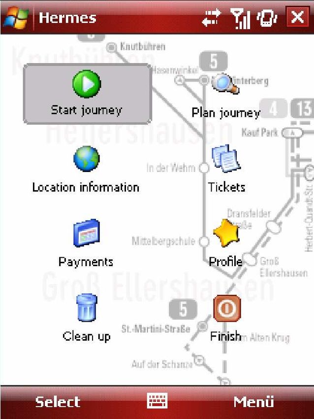
auxiliary processes. The usage case diagram in Figure 3 shows an overview. There are four
primary processes of relevance for the user: he may start using mass transit straight away, he
may plan the use of mass transit, he may access local information on his present geographical
position or he may purchase tickets.
Figure 3: Use case diagram
The actual use of mass transit is the most complex process: it always starts by identifying the
optimal combination of means of transport. If there are several possibilities, the user selects
the one that suits him best. Subsequently there are combinations of footpath guidance,
ticketing and passenger information. These will now be looked into more closely; Figure 45 Design of the Application 18
provides on overview of the possible combinations. In addition, the user can access
information on his present geographic position anytime, e.g. during waiting periods.
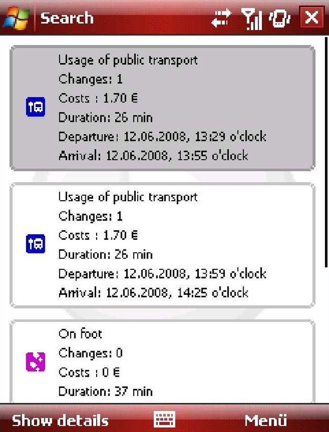
• Find public transport combination
The user specifies his destination. Using his automatically retrieved geographical
location and his profile (including his preferences, characteristics and aversions) the
possible combinations of means of transport are identified and submitted. The user
selects those that suit him best. Destinations may be selected by retrieving addresses
from the address book or by newly entering them, through points of interest, or through
logic location names. Combinations of means of transport once retrieved and selected
may be saved in the calendar. If means of transport need to be ordered as in the case
of taxis, hailed shared taxis or car-sharing vehicles, this will be done by the application
after the user has reconfirmed it or the user will be offered the relevant phone numbers
for dialing.
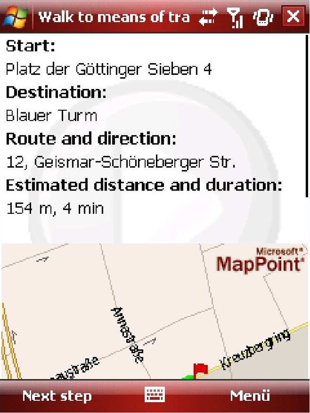
• Footpath guidance
If footpath guidance is required in order to reach a station or a destination, the
application establishes a route to this destination and shows it, using graphics as well
as text descriptions. The program updates this display automatically and always shows
the data relevant at the actual time.
• Ticketing & payment
While processing the ticketing, the application checks whether it will be necessary to
purchase a ticket for the next leg of the journey. It especially checks the stock of tickets
purchased up to the present moment and the characteristics of the user. Should the
purchase of a ticket be required, it carries out this action after the user has
reconfirmed, and initiates payment. All travel plans are taken into consideration in
order to select the most suitable ticket. Alternatively, a so-called "touch & travel"
system may be used [NXP 2008]. The ticket will be saved on the device and can be
presented to the ticket collector as a bar code. Means of transport not requiring tickets,
e.g. taxis, can also be paid via this component. Payment information may be
transmitted via Near Field Communication1 (NFC) or close range radio technologies
like Bluetooth.
1
NFC is a close range radio application with only a few centimeters of coverage. Use of NFC may replace the5 Design of the Application 19
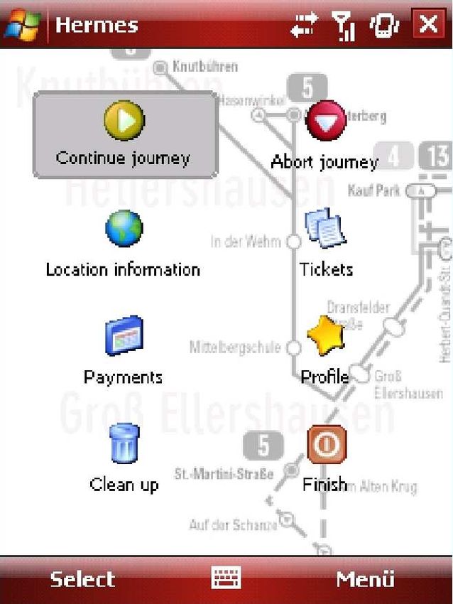
• Passenger information
Passenger information consists of two tasks: it shows the user which means of
transport to take by displaying the line, direction and, where applicable, the platform. It
also displays the next stops and the remaining time of travel and warns the user when
it is time to get off. Real time information about the traffic situation must also be
included in the passenger information. In case of an exceptional situation, the system
recalculates the combination of means of transport and provides updated local
information.
• Local information
If waiting times have to be bridged, the local information provides assistance. It reviews
entertainment opportunities in accordance with the user profile, like restaurants, cafés,
cinemas etc. and displays them. More information like the telephone number of the
operating company can also be provided if required.
Find public transport combination
Footpath necessary
Footpath not
necessary
Footpath guidance
Destination not
yet reached Destination reached Journey finished
Change
of vehicle Ticket acquisition
required
Passenger information Ticketing & payment
Incident
Figure 4: Concatenation of sub-processes in mass transit guidance
complex pairing of devices when using Bluetooth connections [Just 2004].5 Design of the Application 20
The next three processes - planning mass transit usage, displaying location information and
purchasing a ticket - are part of the process previously described. They are different in so far
as they are separated from the process as a whole: planning is done in preparation of a later
usage, and the display of local information may show information about the present
geographical position after local transport usage or totally independent of it. The same applies
to ticket purchase and payment. There are two secondary application cases for the user
included in the application that occur, however, at the start of using the system. In the logic
sequence of usage, the user starts by registering. After uploading the application, he registers
with an unambiguous password. This is necessary, for example, to assign a profile to the user.
When editing the profile, the existing information about the user is displayed and can be edited
and finally saved. For the administrator, there are two processes to be dealt with: the user
administration, consisting of displaying, deleting and blocking of users, and the display of
statistical data, protocols and evaluations of the system. The application has to process a wide
range of data which may refer especially to the following issues:
• the user (user profile)
• mass transit usage (time schedule, combinations of means of transport)
• a geographical location (maps, entertainment opportunities)
• a ticket purchased (area and period of validity)
• a payment effected (recipient, amount, reference)
An identifying feature has to be assigned to the user to ensure his unambiguous identification.
There has to be a profile including information about the user, existing seasonal tickets,
discounts, preferences and aversions [Mertens, Stößlein and Zeller 2004]. Figure 5 provides
an overview. There is also data on the mass transit usage. They consist of a combination of
means of transport, with the name of the line, direction, stations of embarkation,
disembarkation and interim stations as well as platform numbers, if applicable. For the stations
the nominal and real times of arrival/departure and, for optimal travel support, also the
geographical coordinates, have to be included.
The application should be able to provide information on restaurants, cafés and entertainment
opportunities in the vicinity of a geographic location. Maps of the surroundings are also
required for orientation purposes. It should also be possible to retrieve additional information
like the telephone number or the address of a restaurant.5 Design of the Application 21
Object of reference Information
User - name
- address
- date of birth
- preferred mode of payment
- preferred language
Season tickets, - season tickets already purchased
memberships, - existing discounts
discounts - memberships in car-sharing organizations
Preferences - preferred modes of transport
- preferred ticket classes
- preference of booking seats
- preferred food
- preferred opportunities of entertainment
Aversions - phobias
- fears
Figure 5: Content of a user profile
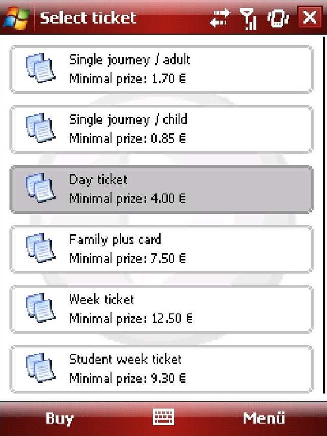
The application supports the user in the purchase of tickets. In order to be able to present
these tickets to a ticket collector and also to avoid multiple purchases, the application needs to
save the ticket information. This includes information on the area and period of validity. To
make the ticket easily controllable, it should be saved in a bar code to be scanned and
checked by the personnel of the transport company. Means of transport that do not require
tickets should also be payable by the application. The information on the payment processes
has to be saved. In addition to these usage data the application should produce protocols and
usage data statistics in order to follow up mistakes and to be able to optimize the service
according to customers' demand.
Following the requirements and the technical concept it is clear that a mobile application for
personal mass transit guidance cannot consist of just one software component. The user
profile needed for personalization has to be saved on a stationary computer to be edited. To
minimize the data transfer via mobile networks the data have to be adapted before they are
transferred to the end device. Therefore a separation into client and server was chosen, as
shown in Figure 6.
On the client side, user as well as administrator use an Internet browser (e.g. Mozilla
Firefox®, Microsoft Internet Explorer®, or Apple Safari®) to initiate functions on the server.
The browser only acts as a display software communicating with a web server. In addition5 Design of the Application 22 there is a client software for mobile end devices whose function goes further than just displaying data transmitted by the server. It is to carry out simple calculations like the distance to the next waypoint via geographical coordinates in order to remain functional even if the mobile network should be unavailable. For this purpose data have to be saved on the end device permanently in the Record Management System (RMS). Figure 6: Component diagram The server mainly works as a storage of profiles, web server for the editing of profiles and the download of the client component and as a so-called "transcoding-proxy" [Fox 1996]. The client component requests data from the server and also transmits its context. The server component retrieves the data from its own data bases or from external server systems. Before transferring them to the client, it adapts them to the clients context. External data available to the project are the data of the geographic information system Microsoft MapPoint® (OpenStreetMap and GeoNames could be used alternatively); the data of local transport companies also need to be integrated. More data sources are imaginable as some data with placemarks are already available on the Internet [Hariharan, Krumm and Horvitz 2005]. Data could also conveniently be produced by user communities [Dornbusch and Huber 2003]. 5.1 Data Transmission Two interfaces are of special relevance in this project: the interface between the client and the server component and the interface with external data sources. Due to the system architecture, a great amount of data needs to be exchanged between the client and the server component. Web services with XML-based message formats based on the widely used SOAP protocol [Weßendorf 2006] are most appropriate. It standardizes the exchange of data as well
5 Design of the Application                                                                  23

as the "Remote Procedure Call" (RPC).

The weaknesses of XML-based message formats, mainly the high overhead of control
characters, should also be mentioned. Studies have shown that the amount of data to be
transferred can be reduced by using binary XML or compression [Kangasharju, Tarkoma and
Raatikainen 2003).

As SOAP documents are transferred by HTTP, the transfer can be encoded using Secure
Socket Layer (SSL) [Hansmann 2003]. The user profile serves as an example for the
exchange formats between client and server. Figure 7 shows an excerpt from the profile file:
the free text entries in the general section; Boolean values in the sections travelling and
settings and references for, e.g. the language selected, in the general section.

 …
         Jane
         Doe
         416 Columbus Ave
         005

         no
         no
         no
         yes

         yes
         yes
         no
         yes
     …

Figure 7: Excerpt from the XML-profile file

The references contained in the profile file may be dissolved into a profile definition file as
shown in Figure 8. The language selected by the user is "Italian" in this case. Both files have
to be available on the device in order to edit the profile.
5 Design of the Application 24
…
…
Figure 8: Excerpt from the XML definition file
Similar XML formats are required for the transfer of other information like combinations of
means of transport; graphics like maps can be added to these files as binary data, or
additionally transferred using picture formats like Portable Network Graphics (PNG) or
Scalable Vector Graphics (SVG). The latter is especially suitable as it is XML-based and freely
scalable on the device in order to dynamically adapt to the screen size available.
5.2 Context Adaptation
The application must be personalized, i.e. adapted to the user context. In order to reduce
entries made by the user and therefore to increase the usability of the application, the entire
context shall be considered. This includes the technical (e.g. bandwidth and available
resources), social (e.g. personal characteristics and preferences) and physical context (e.g.
location, temperature and time) of the situation [Schilit, Adams and Want 1994; ThaeMin and
JongKun 2007]. When looking at the technical context, the technical limitations of mobile end
devices are of main importance: display, networks, remaining free memory and energy level
are the most important changeable characteristics. Network connections are characterized by
their quality, the amount of data transmitted in a given period of time and the usage costs. If a
high quality cost-efficient connection with high bandwidth is available (e.g. a WLAN) more data
should be transferred than when there is a low-quality, expensive connection with low
bandwidth. However, adaptation to the network connection available must not interfere with
the overall quantity and quality of the data transferred but only influence the time of transfer. In5 Design of the Application 25 order to do this, the software has to anticipate which data needs to be transferred. If there is, for example, a cost-efficient and effective connection at the start of the journey, all data concerning connecting and destination stations should be transferred in one go - a process called hoarding [Kubach 2002]. If the connection is cost-efficient but slow, the data are transferred successively in small batches; this is called prefetching. However, this process also depends on the available memory. The output of the application should depend on the size of the mobile device's display, its level of activity on the amount of energy available. Adaptation to the user's context is the most important point in context adaptation as it includes the user's needs, preferences, aversions, competencies and prior knowledge (personalization) as well as the adaptation to the present geographical position (localization). Personalization needs a user profile reflecting the relevant characteristics of the user. It must be possible to edit this profile on the end device because it may change during the journey. The user may, for example, have purchased a season ticket or a discount which needs to be entered into the profile. The profile must be easily editable. It must also be possible to edit it on a PC and transfer it to the end device. Saving it on a server system also facilitates the adaptation of information to the preferences of the user before the data are transferred to the mobile end device. All calculations from the selection of the optimal combination of means of transport to the proposal of adequate entertainment opportunities in exceptional situations have to be in tune with the profile. Localization requires the identification of the present geographic positions and should be done automatically without involving user input. Most appropriately it is done by the network provider by triangulation of several cellular phone network base stations, or satellite-based by GPS (Grejner-Brzezinska 2004). The geographical coordinate thus received can be used in the further course of the program. Start addresses to be put into input boxes in forms could, for example, be replaced by the coordinates automatically retrieved and used for calculating routes. However, it is not only important to establish the geographical position once, but also to keep track of its change over time. While using mass transit, the system must display the next stop, adapt the display automatically and change to textual and graphic aid when changing to another means of transport. In addition, software localization is important as the texts of the application must be easily replaceable by texts in different languages. Adaptation to the physical context is a complicated form of context adaptation as the physical context is difficult to capture with most mobile end devices. While the time of day is readily available, things like temperature and weather can only be estimated indirectly via globally connected sensor networks; characteristics like noise level and illumination are usually not retrievable. In bad weather, the application should minimize distances to be covered on foot and offer route combinations with this option only as a further choice. The same applies if the
5 Design of the Application                                                                                                                                 26

user has indicated an aversion to walking on foot during darkness in the user's profile.
Between sunset and sunrise the application should be able to display maps in night viewing
mode2 in order to reduce strain on the user's eyes.

      Entertainment model                                                     User model                                         Ticket model

    Entertainment        Derived                                     User                Derived                        Ticket                   Derived
    attributes           knowledge on                                attributes          knowledge on                   attributes               knowledge on
                         Entertainment                  Inference                        user           Inference                                ticket

    Entertainment recommendation                                                                                             Ticket recommendation
                                                                                  Inference

                                                                      Public transport model

                                                                     Public              Derived
                                                                     transport           knowledge on
                                                                     attributes          public
                                                                                         transport

                                                                    Public transport recommendation

                                                                                                                             3
Figure 9: Adaptation of recommendations: personalization-rule-system of Hermes

                         Context                                          Rule system                                 User profile
                                          Temperature
                            Connection
      Longitude

                                                                                                                                 Rebates
                                                                                                                    Gender

                                                                                                                                               Phobia
                  Time

                                                                                                           Age
                                                          …

                                                                                                                                                        …

                                                                                   Rules

                                         Automatic activation                                     Decision request/
                                                    of action                                     Decision

                                                                            Application

                                                                                                                                           4
Figure 10: Adaptation of the application: rule system for context-based action regulation

2
    This type of maps uses mainly dark colors (e.g. black, dark blue, dark green) to minimize the effort of adapting
    the eyes when switching between the (dark) surroundings and the map.
3
    Following [Kaspar and Hagenhoff 2003] and [Schackmann and Link 2001].
4
    Based on [Jiang 2004] and [Bardram 2005].
5 Design of the Application 27
While the inference mechanisms for entertainment opportunities are relatively simple, the
recommendation of means of transport needs a great amount of data to be harmonized. This
implies more complex algorithms in order to realize the inferences (cf. Figure 9).
Furthermore certain activities have to be initiated when certain conditions occur (e.g. switching
to night viewing mode after sundown) either in the context or in the user profile; other activities
have to be prevented when such conditions apply (e.g. download of large-scale data over high
priced networks). In this context a rule-based system is appropriate, based on simple IF-THEN
rules [see Jiang 2004, p. 98]. The system needs to have access to the user profile and the
context characteristics as shown in Figure 10. The inference mechanisms and the control
system allow all kinds of context adaptations relevant for the application and, above all, its
personalization.
5.3 Usability
The user-friendliness of the application is to be realized by adhering to the ergonomic criteria
listed in ISO standard 9241. This is important because the application is used while traveling,
which puts the user under time pressure. In order to be able to cope with the application
intuitively, without referring to user manuals, it needs to be divided into logical sections. Where
explanations are needed, help texts must appear directly on the screen. The application has to
be fully controllable by the user, it must be conform to expectations and error-tolerant. Wrong
or incomplete addresses should be completed or corrected automatically. By editing the user
profile the user may adapt the content and the way information is displayed to his personal
deeds. At the same time, the limitations of end devices must be considered. Editing the
complex user profile should not only be possible on the end device, but also on a computer or
notebook. The application should also be able to access addresses stored in the address
book as these can also be edited on a computer and transferred to the end device by
synchronization [Hansmann 2003].
5.4 Security and Data Protection
Data protection and security are very important in this application, as profile data must not get
into the hands of third parties. They contain payment information and the great variety of
information included makes it possible for third parties to assume the identity of the user
("identity theft") [Ziemann 2004]. Furthermore, the position of the user may be identified by6 Implementation of the Application 28
looking at the information requests, and movement profiles may be generated. The use of a
mobile application always includes the danger of the end device being stolen, and besides the
data are transmitted via the air interface which has inherent security problems. Therefore the
following measures must be taken:
• All data transfer has to be encoded.
• In order to edit the profile on a computer or notebook, a registration including user
name and password is required.
• When editing the profile, sensitive payment information like account numbers or credit
card numbers are only partly displayed to prevent readout.
• In order to impede the decompilation of the mobile application the information included
in the code must be veiled ("code obfuscation") [Zhu, Yin and Zhang 2005].
• The end user must be informed about the use of his data; data protection guidelines5
have to be published to do so.
• Data are only saved on the end device as long as they are actually needed. In
addition, the user has the possibility to delete all data.
6 Implementation of the Application
Now that the requirements and the conception of a mobile application for personalized mass
transit guidance have been identified, its actual implementation shall be described. At first, the
technical environment of the product is to be explained, starting with the software cooperating
with the application, and including the programming, description and markup languages used.
Then the development environment will be presented, and finally an overview of the
implemented application and the limitations of implementation will be provided. To attain a
realistic prototype, a logo for the application and a consistent color scheme were developed.
The application has been named Hermes.
When looking at the technical product environment, client and server components have to be
differentiated as they are being executed on two different platforms. Both components have
been developed in the programming language Java as it is platform-independent, object-
oriented and widely used [Flanagan 2001]. Its platform-independence makes Java the optimal
5
The Platform for Privacy Preferences (P3P) of the World Wide Web is the standard for
this Consortiums (W3C), see: http://www.w3c.org/p3p/.You can also read