Impact of Earthquakes on the Transportation Infrastructure of Indonesia: A Preliminary Study - Civil ...
←
→
Page content transcription
If your browser does not render page correctly, please read the page content below
Civil Engineering Dimension, Vol. 21, No. 1, March 2019, 19-28                                        DOI: 10.9744/CED.21.1.19-28
ISSN 1410-9530 print / ISSN 1979-570X online

     Impact of Earthquakes on the Transportation Infrastructure of
                    Indonesia: A Preliminary Study

                   Amirsardari, A.1, Sofi, M.1*, Lumantarna, E.1, Imran, I.2, and Duffield, C.1

        Abstract: Indonesia is a high seismic region and one of the most vulnerable countries prone to
        experiencing damaging earthquakes. It is critical that lifeline infrastructure remain operational
        or is quickly remediated after an earthquake to minimise physical, social, and economical losses.
        Not much work has been carried out in understanding the effect of earthquakes on transpor-
        tation infrastructure systems. This study aims to gain a better understanding of the impact of
        earthquakes on the transportation infrastructure in Indonesia. This is achieved by firstly review-
        ing the frameworks and tools for conducting seismic risk assessment of lifeline infrastructure.
        The critical components of the transportation system are then identified. Various forms of tran-
        sportation infrastructure damage caused by earthquakes are discussed. An overview of the
        damaging earthquakes for the past 20 years is presented. Finally, conclusions and recommen-
        dations are provided about the future work required for conducting risk assessment of the
        transportation infrastructure in Indonesia

        Keywords: Earthquake vulnerability; transportation system; infrastructure; Indonesia; seismic
        risk.

Introduction                                                           Most of the research that has been conducted thus
                                                                       far has focused on assessing the seismic performance
Indonesia is one of the world’s most vulnerable coun-                  of structures and point systems [3,4]. Less work has
tries prone to natural disasters, including earthqua-
                                                                       been conducted in understanding the effect of earth-
kes, tsunamis, volcanic eruptions, and seasonal ty-
phoons [1]. Natural disasters can have catastrophic                    quakes on lifelines including transportation systems.
impact on both a regional and national level as they                   One of the main reasons for this is due to the higher
cause physical, social, and indirect economic losses.                  level of complexity involved in accurately conducting
Physical losses comprise of direct losses due to                       the seismic assessment of lifelines which often in-
damage to the environment, including structures                        clude both structural and geotechnical failure me-
and infrastructures. Social losses include fatalities,                 chanisms and the interdependency of the various
injuries, emotional harm, and social unrest. Indirect                  components of the system.
economical losses account for losses induced post-
earthquake due to changes caused to daily activities
                                                                       The aim of this study is to gain a better understand-
of a region such as loss or reduced functionality of
various systems and services.                                          ing of the impact of earthquakes on the transporta-
                                                                       tion system in Indonesia. A brief review is provided
Often, risk assessment is conducted to reduce losses                   of the frameworks for conducting seismic risk assess-
and to mitigate the effect of natural disasters. Risk                  ment which are particularly suitable for lifelines.
mitigation strategies are particularly important for
                                                                       The various components of the transportation sys-
lifelines; which are defined as systems which are
necessary for human life and urban function [2]. An                    tem with relation to Indonesia are identified and the
important lifeline infrastructure is the transporta-                   various forms of physical damage caused by earth-
tion system. Its performance is critical during and                    quakes to the transportation infrastructure are dis-
immediately after a disastrous event as they are                       cussed. Furthermore, an overview of the damaging
required for emergency response and disaster relief                    earthquakes for the past 20 years is presented to
efforts. In the long-term their performance is also                    provide an indication of the recent losses which have
important in order to minimise indirect losses since                   occurred in Indonesia due to the damage caused to
transportation systems provide the means for many                      transportation systems. Based on the findings, re-
important daily functions.
                                                                       commendations and conclusions are provided about
1 Department of Infrastructure Engineering, University of Mel-         the future work required for conducting risk assess-
bourne, Parkville, 3010, AUSTRALIA                                     ment of the transportation system in Indonesia.
2 Bandung Institute of Technology, Bandung, Jl. Ganesha No.10,

Lb. Siliwangi, Coblong, Bandung 40132, INDONESIA
*Corresponding author; email: massoud@unimelb.edu.au                   Framework for Seismic Risk Assessment
Note: Discussion is expected before June, 1st 2019, and will be
published in the “Civil Engineering Dimension”, volume 21,             One of the first initiations for assessing the seismic
number 2, September 2019.                                              vulnerability and impact of disruption of lifeline sys-
Received 17 December 2018 revised 20 January 2019; accepted 19         tems was in 1988 by the Applied Technology Council
March 2019

                                                                  19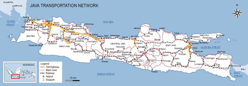
Amirsardari, A. et al. / Impact of Earthquakes on the Transportation Infrastructure of Indonesia / CED, Vol. 21, No. 1, March 2019, pp. 19–28

(ATC) with the support from the Federal Emergency                         required. This usually necessitates the implementa-
Management Agency (FEMA). The research which                              tion of a geographical information system (GIS). This
was conducted is presented in ATC 25/FEMA 224                             has led to the development of numerous software
report; “Seismic vulnerability and impact of disrupt-                     packages and tools, such as Redars [7] and Hazus
tion of lifelines in the conterminous United States,”                     [8]. Redars is seismic-risk-analysis software package
[2]. The proposed framework, illustrated in Figure 1,                     developed by the California Department of Tran-
consists of four steps: (i) development of a national                     sportation under the FHWA-MCEER Motorway
lifeline inventory database, (ii) development of seis-                    Project (initiated in 1992) which is capable of estima-
mic vulnerability functions for each lifeline compo-                      ting the structural and operational losses of tran-
nent/system (these functions describe the expected                        sportation systems [5,6]. HAZUS methodology and
seismic performance of each lifeline as well as the                       software package has also been developed in the US,
time required to restore damaged infrastructure and                       it is capable of predicting the direct physical damage
facilities to their pre-earthquake capacity or usabi-                     and functionality of various transportation compo-
lity, (iii) characterisation and quantification of the                    nents, however, unlike REDARS, it is not able to
seismic hazard nationwide, and (iv) development of                        account for the interdependence of various transpor-
direct damage loss estimates (i.e., damage resulting                      tation systems and it is incapable of conducting net-
directly due to ground shaking and other induced                          work analysis [5]. Ina SAFE is a similar tool which
mechanisms) and indirect economic loss estimates                          has been developed for Indonesia by the Indonesian
(i.e., losses due to disruptions to lifeline functionality)               Government (BNPB), Australian Government, and
for a particular earthquake scenario.                                     the World Bank (GFDRR) [9]. While the platform is
                                                                          freely available the data required to assess the risk
The framework presented in Figure 1 has formed the                        of transportation systems is incomplete and it does
foundation of many other studies which have con-                          not incorporate the interdependence of various tran-
ducted assessment of lifelines. However, most of the                      sportation components.
research that has been conducted has focused on
quantifying the direct losses due to earthquakes for                      Components of the Transportation Infrastruc-
isolated structures/infrastructure. It is only over the                   ture
recent years that there has been a move to quanti-
fying indirect losses and adopting network analysis                       A critical part of accurately conducting risk assess-
methods to account for the interdependencies of net-                      ment of the transportation system involves develop-
work components [e.g., 5,6]. Indirect losses are                          ing an inventory of the key components of the tran-
dependent on residual-capacity or time-to-restora-                        sportation infrastructure. The transportation system
tion curves which define the percentage of function                       can be categorised into four groups: roadway, rail-
restored as a function of time. For point systems                         road, waterway, and air transportation system. The
(e.g., airports, schools, and hospitals), the time-to-                    components of the various groups are described
restoration curves are developed for isolated struc-                      below in relation to Indonesia. It is noted that most
tures. However, for linear systems (e.g., roadways                        of the information which is presented is obtained
and railroads), the time-to-restoration curves require                    from the country report conducted by the Association
connectivity analyses and serviceability analyses [2].                    of Southeast Asian Nations (ASEAN) Coordinating
                                                                          Centre for Humanitarian Assistance on Disaster
To accurately conduct the risk analysis of lifeline                       Management (AHA Centre) and the Japan Inter-
infrastructures extensive spatial distribution data is                    national Cooperation Agency [10].

                Figure 1. Framework for Conducting Seismic Risk Assessment of Lifelines, adapted from [2]

                                                                     20
Amirsardari, A. et al. / Impact of Earthquakes on the Transportation Infrastructure of Indonesia / CED, Vol. 21, No. 1, March 2019, pp. 19–28
Roadway Transportation System bridges in Indonesia with a combined length of
1138 km. Approximately 77% (734 km) of the brid-
The main components of the roadway transportation ges are part of provincial, regency, and city roads,
system include: paved and unpaved roads, bridges, and the remaining 23% (404 km) are part of nation-
overpasses, underpasses, tunnels, embankments, nal roads.
slopes, retaining walls, and maintenance facilities.
The type of damage that can be experienced by Railroad Transportation System
roadways includes surface displacements, rupturing,
liquefaction, slope instability, and earthquake indu- In addition to the vulnerabilities of the roadway
ced flooding. In particular, bridges and overpasses system, the railroad system is also vulnerable to ver-
have been identified to be the most vulnerable com- tical and horizontal track misalignments, structural
ponents of the transportation system [6] since in damage to railroad buildings, and overturned rail-
addition to ground surface and geotechnical failures cars and locomotives. Furthermore, disruption may
they are also vulnerable to complete structural col- also occur due to traffic signal failure. Indonesia has
lapse. In Indonesia the total road length is estimated a total train line of 6,720 km, however, currently
to be 497,000 km, where approximately 8% are only 4,600 km of the train line is in use. The train
national roads, 11% are provincial roads, and 81% lines are currently only operable in Java and Suma-
are regency roads. There are also around 93,000 tra Island, with approximately more than two thirds
Figure 2. Transportation System of Java Island [10]
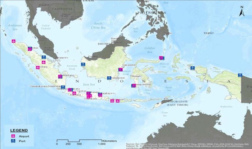
Figure 3. The Major Ports and Airports of Indonesia [10, 11]
21
Amirsardari, A. et al. / Impact of Earthquakes on the Transportation Infrastructure of Indonesia / CED, Vol. 21, No. 1, March 2019, pp. 19–28

of the track lines being located in Java Island. An
overview of transportation system of Java Island,
including the railway system, is provided in Figure
2.

Waterway Transportation System
The main components of the waterway transporta-
tion system include: port facilities, rivers, canals,
channels, banks, levees and dams. The waterway
system can be categorised as coastal waterways;
which includes traffic along the coasts, importing
and exporting of freight from the sea, and inland
waterways which includes traffic and movement of
goods within a region. The maritime transportation
system is particularly important for Indonesia since                      Figure 5. Collapsed Airport Terminal Building in Simeu-
it consists of approximately 17,000 islands. In total,                    lue [11]
Indonesia has 300 public ports, of which 43 are
international ports and 14 are ports assigned to                          Ground Failures
ASEAN.
                                                                          There are various forms of ground failures which can
Air Transportation System                                                 occur due to earthquakes, including liquefaction and
The critical components of the air transportation                         lateral spreading, slope instability, and subsidence.
system includes: terminals, runways, power, commu-                        Liquefaction describes the process of the soil beha-
nication and radar, and liquid fuel and transport. In                     ving in a liquid manner due to sudden loss of
total Indonesia has 187 airports for civil aviation                       strength and stiffness due to the applied stresses
usage and 16 of these are international airports. The                     under ground shaking. It induces failure to the foun-
location of the major ports and airports are provided                     dations of the transportation components as the
in Figure 3.
                                                                          bearing strength is significantly reduced. Further-
Physical Forms of Earthquake Damage                                       more, there may also be lateral spreading where a
                                                                          layer of stable soil slides over the top of a liquefied
It is critical that all the various forms of earthquake                   layer [12]. Slope instability occurs due to the loss of
hazard are quantified when assessing the seismic                          the cohesive stability of the slope during ground
risk of the transportation infrastructure. The main
                                                                          shaking. It is particularly an issue for road and rail-
forms of direct physical damage caused by earth-
quakes, includes: ground shaking, ground failures,                        way embankments. Earthquake induced rockfalls
faulting, and induced physical damages.                                   and landslides can significantly damage and block
                                                                          roadways. The shaking from earthquakes can cause
Ground Shaking                                                            land subsidence by settling and compacting unconso-
Ground shaking can directly cause physical damage                         lidated soil. Furthermore, large areas of land can
to various components of the transportation systems,                      subside due to offsets of fault lines. Examples of
including structural damage to facility buildings,                        ground failures observed in Indonesia due to various
bridges, storages, signal systems, overpasses, tun-                       earthquake events are provided in Figures 6 to 9.
nels, and derailment of railcars and locomotives.
Examples of damage caused by ground shaking from
past earthquakes in Indonesia are provided in
Figures 4 and 5.

                                                                          Figure 6. Damage Caused to an Approaching Ramp to Siti
Figure 4. Displaced End Support of a Bridge in Nias [11]                  Nurbaya Bridge [13]

                                                                     22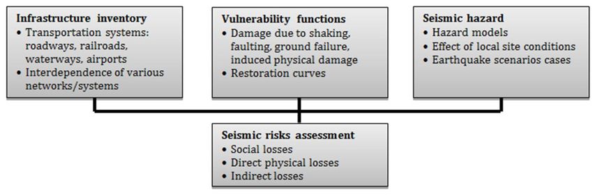
Amirsardari, A. et al. / Impact of Earthquakes on the Transportation Infrastructure of Indonesia / CED, Vol. 21, No. 1, March 2019, pp. 19–28

Figure 7. Cracks on an Unpaved Road due to Lateral                       Figure 10. Damage to Roads due to Fault Rupture and
Spreading, March 28 Nias & Simeulue Earthquake [11]                      Liquefaction, Palu Earthquake [15]

                                                                         Induced Physical Damages
                                                                         Induced physical damages due to an earthquake
                                                                         includes: tsunami, flooding, dam and levee failures,
                                                                         landslides, fires, and release of hazardous products.
                                                                         Indonesia is particularly vulnerable to experiencing
                                                                         tsunamis after an earthquake. Tsunamis can cause
                                                                         extensive damage, including washing out of bridge
                                                                         piers and embankments, derailment and overturn-
                                                                         ing of railcars and locomotives. Dam and levee
                                                                         damages can also cause significant losses to the
                                                                         nearby community, especially during high water pe-
                                                                         riods. Examples of damage caused by tsunamis in
                                                                         Indonesia are provided in Figures 11 and 12.
Figure 8. Cracks on the Road due to 2016 Pidie Jaya
Earthquake [14]

                                                                         Figure 11. Steel Truss Bridge Swept off its Supports
                                                                         during the Aceh Earthquake [16]

Figure 9. Settlement of a Bridge Approach in Simeulue
[11]

Faulting
In high seismic regions earthquakes typically occur
due to the rupturing of a fault because of built up of
stresses in the crust. This causes large surface dis-
placements which can cause significant damage to
transportation systems which cross the rupture. For
example, train track misalignment can occur and the
separation of bridge piers. An example of significant
damage caused to roadways due to fault rupture                           Figure 12. Debris Blocking Streets due to Damage Caused
(and liquefaction) is illustrated in Figure 10.                          by Tsunami in Banda Aceh [16]

                                                                    23
Amirsardari, A. et al. / Impact of Earthquakes on the Transportation Infrastructure of Indonesia / CED, Vol. 21, No. 1, March 2019, pp. 19–28

Review of Damage Caused by Previous Earth-                                seismic excitations and tsunamis. The earthquake
quakes in Indonesia                                                       and the tsunami which followed caused more than
                                                                          200,000 fatalities. The total cost of the earthquake
The following section provides an overview of the
                                                                          has been approximated to be US$ 4.5 billion (corres-
damaging earthquakes which have recently occurred                         ponding to 54% regional GDP) [19]. Approximately
in Indonesia. Detailed information about all of the
                                                                          39% of the total loss was due to the damage caused
earthquakes are not readily available, however,
                                                                          to houses and buildings, 20% to the infrastructure,
where possible information regarding the damage
                                                                          and the remaining costs due the losses caused to the
caused to the transportation system is discussed.
                                                                          productive sectors and cross sectoral [20]. More than
The information presented assists in gaining a better                     60% of the losses caused to the infrastructure was
understanding of the impact of earthquakes on the
                                                                          due to the damage caused to the transportation
transportation infrastructure with respect to phy-
                                                                          infrastructure from which 73% was due to direct
sical, social, and economical losses.
                                                                          losses and 27% due to indirect economical losses [20].
Enggano-Bengkulu Earthquake (June 4, 2000)                                In addition to the collapse of many buildings, the
                                                                          land transportation system in Banda Aceh was com-
This earthquake occurred in south of Sumatra                              pletely disabled due to the tsunami. This significan-
beneath the Indian Ocean at a depth of 33 km and                          tly compromised disaster reliefs and response pro-
had a magnitude of 7.9 [17]. Most of the damage                           cedures. Many bridges had collapsed due to tsunami
occurred in the city and province of Bengkulu and                         forces or had been swept off their piers and abut-
the Enggano Island. In total, it resulted in 90 fatali-                   ments, furthermore the main roads and small
ties and over 2000 injuries from which approxi-                           streets were completely destroyed or blocked due to
mately a thousand were reported as serious injuries                       debris of collapsed buildings and trees [16]. Interes-
[17]. A series of aftershocks continued for two weeks                     tingly, some piers and abutments were left unda-
and eventually a second earthquake occurred with a                        maged (even though the bridge structure had been
similar magnitude and location. No tsunamis were                          swept away) and they were utilised for the construc-
generated by the earthquakes.                                             tion of new bridges during disaster relief efforts [16].
A detailed report about the damage caused by the                          Nias-Simeulue Earthquake (March 28, 2005)
earthquake was provided by the United Nation Di-
saster Assessment and Coordination (UNDAC) team                           The Nias-Simeulue earthquake was of magnitude
[18]. The main damage was reported to be caused to                        8.7 and had a depth of approximately 30 km [21]. It
houses, with 1800 houses reported as completely                           was followed by a series of strong aftershocks and a
destroyed and 10,196 as seriously damaged. In terms                       local tsunami. It resulted in approximately 1000
of the transportation infrastructure, significant                         fatalities and more than 61,000 injuries [11]. The
damage was caused to bridges with four bridges                            costs associated with the earthquake and tsunamis
reported to be destroyed, 11 heavily damaged, and                         have not been reported. Most of the transportation
20 lightly damaged. However, the bridges which                            damage was caused to bridges, predominantly due to
were not collapsed were used after the earthquake.                        displacement of supports (30 to 100 cm), settlement
Most of the roads also remained operational                               of bridge abutments, as well as differential settle-
although some sustained damage including cracking                         ment due to lurching, liquefaction, and uneven com-
of the pavement, minor landslides and fallen rocks                        paction [11].
on the roadside. Some harbour facilities were also
damaged. The Bengkulu airport remained fully ope-                         Yogyakarta and Central Java Earthquake
rational and only suffered superficial damage to                          (May 27, 2006)
terminal buildings. The financial costs associated                        The Yogyakarta and Central Java earthquake was a
with the earthquake have not been reported.                               shallow earthquake with a depth of 33 km and with
                                                                          a magnitude of 6.3 [22]. It resulted in 5,700 fatalities
Aceh Earthquake (December 26, 2004)
                                                                          and more than 40,000 injuries, furthermore it was
The Aceh earthquake was a magnitude 9.3 shallow                           followed by Mount Merapi’s volcanic activity [22].
earthquake with a depth of approximately 30 km                            The total cost associated with the earthquake was
which occurred due to rupturing of the subduction                         approximated to be US$ 3.1 billion (corresponding to
zone between the Indian plate and the Burma micro-                        41% regional GPD), where 78% of the total cost was
plate [16]. It was followed by a series of very destruc-                  due to direct damage (i.e., costs associated with
tive tsunamis with wave heights exceeding 20 m.                           replacement and reconstruction) and 22% of the total
Damage was caused to 19 countries including Indo-                         cost was associated with economic losses (i.e., costs
nesia, Malaysia, Myanmar, Thailand, Bangladesh,                           related to reductions in economic activities and in
Sri Lanka, and India [16]. However, Banda Aceh                            personal and family income post-earthquake) [19,
suffered the most and the damage was due to both                          22].

                                                                     24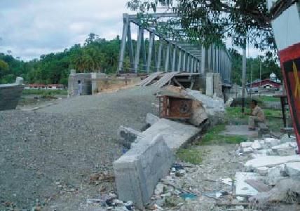
Amirsardari, A. et al. / Impact of Earthquakes on the Transportation Infrastructure of Indonesia / CED, Vol. 21, No. 1, March 2019, pp. 19–28

The details of the damage caused by the earthquake                       regional GPD [19]. Approximately 80% of the total
are provided in the report prepared by the The                           cost was due to damages and losses associated with
Consultative Group on Indonesia [22]. Overall the                        infrastructure; predominantly related to the collapse
damage was predominantly caused to houses and                            and damage of houses and buildings [28]. Minor
buildings. The impact of the earthquake on the                           damage was reported to be caused to the tran-
transportation system was minimal and the recovery                       sportation infrastructure (roads and bridges); mainly
time was relatively quick. The cost associated with                      due to landslides and ground settlements. However,
the transportation & communication systems were                          the damaged caused to road segments was reported
reported to be only 0.3% of the direct damage cost                       to make access to certain areas difficult and it also
and zero of the economic loss. However, minor dama-                      delayed the transportation of goods and services
ge was caused to a widespread of roads, bridges,                         during disaster relief efforts [28]. Nevertheless, most
mainline railway tracks and associated infrastruc-                       roads were made accessible after a few days from the
ture (station buildings, signals and telecommunica-                      earthquake and priority of remediation was given to
tions), and localised damage to Yogyakarta’s airport.                    key roads in mountainous regions vulnerable to
The cause of damage was mainly due to minor sub-                         experiencing landslides, [28]. It is noted that even
sidence and pavement deformation, longitudinal                           though the roads were re-opened, in some cases they
cracking of bridge decks, and unfastening of expan-                      were at risks of further failures especially due
sion joints.                                                             aftershocks or heavy rainfalls.

Pangandaran (West Java Province) Earth-                                  Mentawai Earthquake (October 25, 2010)
quake (July 17, 2006)
                                                                         The Mentawai earthquake was a shallow earth-
The Pangandaran earthquake was a magnitude 7.7                           quake with a depth of 21 km and a magnitude of 7.7,
earthquake with a depth of 34 km [23]. It was follow-                    it was also followed by a tsunami [29]. It resulted in
ed by a tsunami which caused most of the damage to                       the death of more than 445 people and more than
the Pangandaran region [23]. The perceived shaking                       170 people were injured. The damage was mainly
intensity was low, however, significant displacement                     caused to houses, and no damage was reported to be
of the seabed occurred which caused the tsunami                          caused to the transportation system [29].
[23]. It resulted in the death of more than 660 people
and caused injuries to more than 9,000 people [24].                      Aceh Earthquake (July 2, 2013)
The total cost was estimated to be US$ 44.7 million
                                                                         The Aceh earthquake which occurred in 2013 was a
[24]. Most of the damage was caused to low- to mid-
                                                                         very shallow earthquake with a depth of only 10 km
rise buildings due to the tsunami only and only mi-
nor damage was caused to the lifeline infrastructure                     and a magnitude of 6.1 [30]. It resulted in 35 fata-
[23, 25]                                                                 lities and 275 injuries. The damage was predomi-
                                                                         nantly caused to buildings, including houses, schools,
Bengkulu Earthquake (September 12, 2007)                                 and mosques. Some damage was also caused to the
                                                                         transportation system; mainly due to landslides
The Bengkulu earthquake was a magnitude 8.4                              blocking the roads [30].
earthquake and it was approximated to have a depth
of 30 km [26]. It was followed by two large after-                       Pidie Jaya, Aceh Earthquake (December 7,
shocks (with magnitude 7.9 and 6.8) and a series of                      2016)
tsunamis [26]. In comparison to other earthquake of
similar magnitudes the casualties was lower, with a                      The Pidie Jaya earthquake was also another very
fatality rate of 25 and 41 injuries. However, the eco-                   shallow earthquake with a depth of 13 km and a
nomic loss was high, it has been estimated as                            magnitude of 6.5 [14]. It resulted in the death of 104
US$ 164 million [27]. Most of the damage was                             people and caused injuries to more than hundreds of
caused to houses. Moderate damage was caused to                          people. Most of the damage caused by the earth-
the transportation system, with most of the damage                       quake was to buildings; however, moderate damage
reported to be caused to the roads (along the shore-                     was also caused to roads and bridges, predominantly
line); due to rupture, settlement due to landslides,                     due to cracking of pavements. All primary roads
liquefaction [27]. Furthermore, several major bridges                    were functional despite the damage [14].
were also damaged, due to settlement of piers and
                                                                         Lombok Earthquake (July-August, 2018)
failure of abutments due to liquefaction [27]. Howe-
ver, the roads and bridges were accessible after the                     A series of earthquakes recently occurred in Lombok
earthquake even though they were damaged.                                Island, with five major shocks occurring on 29th of
                                                                         July (magnitude 6.4), 5th of August (magnitude 7.0),
West Sumatra Earthquake (September 30,                                   9th of August (magnitude 6.2), 19th of August (magni-
2009)                                                                    tude 6.5 and 6.9) [31]. In total, there were 571 fata-
The West Sumatra earthquake was of magnitude 7.6                         lities and more than 7,700 injuries [31]. Most of the
and had a depth of approximately 80 km [13]. It                          damage was caused to buildings (predominantly
resulted in the death of just under 1,200 people and                     houses) and a total cost of US$ 528 million was
a total cost of US$ 2.3 billion, corresponding to 30%                    reported [31].

                                                                    25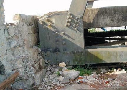
Amirsardari, A. et al. / Impact of Earthquakes on the Transportation Infrastructure of Indonesia / CED, Vol. 21, No. 1, March 2019, pp. 19–28

Palu Earthquake (September 28, 2018)                                      In addition, it is observed that landslides cause a
                                                                          high risk after an earthquake. The roadways are
The latest damaging earthquake experienced by                             often used immediately after an earthquake even if
Indonesia is the Palu earthquake which occurred on                        damage has occurred due to landslides since often
the 28th of September. It was a very shallow earth-                       there are limited alternative routes in regions where
quake, with a depth of 10 km and a magnitude of                           landslides occur (for example in mountainous regi-
7.5. It was also followed by a damaging tsunami with                      ons). Hence, it is important that prioritisation is
wave heights reaching 7 m [15]. Based on surveys                          given to assessing the seismic performance of road-
conducted up until 3rd of October, the number of                          ways near slopes and on embankments. Further-
fatalities has been reported to be over 1400 and more                     more, mitigation measures must be taken to reduce
than 2500 injuries [15]. The earthquake and tsuna-                        the risk of landslides, including re-alignment of
mi caused severe damage to houses, buildings, and                         roads to safer routes, improvements to drainage of
lifelines [15]. Certain regions experienced significant                   the slopes, use of retaining walls to support fill
liquefaction which caused the collapse of buildings                       embankments and to provide protection from land-
and trees. In particular, many roads were damaged                         slips and rockfalls, and improved monitoring of
or blocked by debris and bridges had collapsed                            slopes.
predominantly due to the tsunami forces. The dama-
ge to the roadway was reported to cause significant                       In addition, the observation of the reported earth-
challenges and delays for rescuers and relief aids.                       quakes in this study indicates that the main damage
Furthermore, the ports near Palu were significantly                       that has occurred to the transportation infrastruc-
damaged as well as the Palu airport and therefore                         ture in Indonesia in the past 20 years has been due
only a limited number of planes were able to land                         to tsunamis induced by earthquakes. This is because
and take off for disaster relief purposes. The costs                      strong tsunamis can wipe out regions of a city and
                                                                          there are not many design solutions (in terms of the
associated with the earthquake and tsunamis have
                                                                          structural design of the infrastructure) to minimise
not yet been reported.
                                                                          the effect of tsunamis. The most important mitiga-
                                                                          tion strategy that can be put into place includes
Summary and Recommendations                                               warning systems and planned evacuation routes.
The current state of the art approach for assessing                       Therefore, in terms of conducting risk assessment an
the seismic performance of infrastructure, namely                         important aspect (in addition to incorporating the
transportation systems, requires extensive spatial                        hazard and the vulnerability of the infrastructure)
distribution data which needs to be implemented in                        involves assessing the connectivity of the transporta-
GIS platforms. Currently there is a tool which is                         tion routes with respect to ease and speed of eva-
being developed to assess the risk of infrastructure                      cuation of residents. Furthermore, since bridges pro-
in Indonesia for various forms of natural hazards.                        vide important links (usually over water bodies) the
                                                                          assessment of their seismic performance is critical.
However (to the knowledge of the authors), its use
                                                                          Regions where the failure of a single bridge can pre-
for assessing the seismic performance of the tran-
                                                                          vent the movement of people to a safe area from
sportation system has not been implemented. Such
                                                                          tsunamis must be identified and either the seismic
an initiation requires extensive resources including                      resilience of the bridge needs to be improved or
time and money. Thus, it is important that the                            preferably alternatives routes must be constructed.
critical components of the transportation system are
implemented and assessed first to ensure the mitiga-                      Funding:
tion of risks for future earthquakes.
                                                                          The funding to undertake this study was provided by
The reconnaissance of damaging earthquakes which                          the Australia-Indonesia Centre (Project Reference
have occurred in Indonesia in the past 20 years                           IMONWingITB01; Project title: Infrastructure Rapid
indicates that the extent of damage caused to the                         Start Project).
transportation infrastructure varies greatly. In gene-
ral, the transportation infrastructure, especially the                    References
ones on land, are used immediately after an earth-                        1. UNISDR & the World Bank, Synthesis Report on
quake even if moderate level of damage takes place.                          Ten ASEAN Countries Disaster Risks Assess-
Furthermore, the review of the damage of the tran-                           ment: ASEAN Disaster Risk Management Initia-
sportation infrastructure in Indonesia revealed that                         tive, 2010, The International Strategy for
the most critical component is bridges (also identified                      Disaster Reduction (ISDR) (United Nations),
by other studies). The failure and collapse of bridges                       and the World Bank.
has the most catastrophic impact on cities because                        2. Applied Technology Council, ATC 25/FEMA
they usually provide the means to cross water bodies                         224: Seismic Vulnerability and Impact of
and hence alternative routes are limited. Thus, their                        Disruption of Lifelines in the Conterminous
failure can delay or even prevent disaster relief and                        United States, in Earthquake Hazard Reduction
response efforts. Furthermore, the failure of bridges                        Series 58. 1991, Applied Technology Council
can significantly impact the post-earthquake functio-                        (ATC), Federal Emergency Management Agency
nality of the city.                                                          (FEMA).

                                                                     26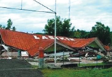
Amirsardari, A. et al. / Impact of Earthquakes on the Transportation Infrastructure of Indonesia / CED, Vol. 21, No. 1, March 2019, pp. 19–28

3. Rosidi, D., Seismic Risk Assessment of Levees.                        16. Saatcioglu, M., Ghobarah, A., and Nistor, I.,
    Civil Engineering Dimension, 9(2), 2007, pp. 57-63.                      Effects of the December 26, 2004 Sumatra
4. Lumantarna, E., Lam, N., and Wilson, J., Seis-                            Earthquake and Tsunami on Physical Infra-
    mic Assessment of Structures in Regions of Low                           structure, ISET Journal of Earthquake Techno-
    to Moderate Seismicity, Civil Engineering                                logy, 42(4), 2005.
    Dimension, 14(3), 2012, pp. 156-165.                                 17. Abercrombie, R.E., Antolik, M., and Ekström, G.,
5. Kappos, A., et al., Seismic Risk of Inter-urban                           The June 2000 Mw 7.9 Earthquakes South of
    Transportation Networks, Procedia Economics                              Sumatra: Deformation in the India-Australia
    and Finance, 18, 2014, pp. 263-270.                                      Plate, Journal of Geophysical Research, 108(B1),
6. Stergiou, E. and Kiremidjian, A.S., Treatment of                          2003. pp. 6-16.
    Uncertainties in Seismic-risk Analysis of Tran-                      18. UN Office for the Coordination of Humanitarian
    sportation Systems, in PEER Report 2008/02.                              Affairs. UNDAC Team Mission Report Bengkulu
    2008, Pacific Earthquake Engineering Research                            Earthquake, Sumatra, Indonesia 6-16 June
    (PEER) Center, College of Engineering, Univer-                           2000. 2000 [cited 2018 1/11]; Available from:
    sity of California, Berkeley.                                            https://reliefweb.int/report/indonesia/undac-
7. Werner, S.D., et al., REDARS 1: Demonstration                             team-mission-report-bengkulu-earthquake-
    Software for Seismic Risk Analysis of Highway                            sumatra-indonesia-6-16-jun-2000.
    Systems, n.d, Federal Highway Administration.                        19. The World Bank, Indonesia: Advancing a Natio-
8. Federal Emergency Management Agency                                       nal Disaster Risk Financing Strategy - Options
    (FEMA), Using HAZUS-MH for risk assessment,                              for Consideration, 2011, Global Facility for Disas-
    in FEMA 433 - HAZUS-MH Risk Assessment                                   ter Reduction and Recovery (GFDRR), The Inter-
    and User Group Series. 2004: Washington, D.C.                            national Bank for Reconstruction and Develop-
9. Ina SAFE Documentation, 2014 [cited 2018 1/11];                           ment/The World Bank.
    Available from: http://docs.inasafe.org/en/index.                    20. The Consultative Group on Indonesia, Indonesia:
    html.                                                                    Preliminary Damage and Loss Assessment - the
10. AHA Centre & Japan International Cooperation                             December 26, 2004 Natural Disaster. 2005,
    Agency, Country Report Indonesia: Natural                                BAPPENAS and the International Donor Com-
    Disaster Risk Assessment and Area Business                               munity.
    Continuity Plan Formulation for Industralia                          21. WHO, Emergency Situation Report No. 16, 18
    Agglomerated Areas in the ASEAN Region. 2015,                            May 2005: Earthquake in North Sumatra
    ASEAN Coordinating Centre for Humanitarian                               Province and NAD Province, Indonesia. 2005,
    Assistance on Disaster Management (AHA Cen-                              World Health Organization (WHO), Indonesia.
    tre), Japan International Cooperation Agency,                        22. The Consultative Group on Indonesia, Prelimi-
                                                                             nary Damage and Loss Assessment: Yogyakarta
    OYO International Corporation, Mitsubishi Rese-
                                                                             and Central Java Natural Disaster. 2006, Natio-
    arch Institute Inc, CTI Engineering International
                                                                             nal Development Planning Agency (BAPPENAS),
    Co. Ltd.
                                                                             the Yogyakarta and Central Java Provincial
11. EERI, Learning from Earthquakes: The Northern
                                                                             Development Planning Agencies (BAPEDAs),
    Sumatra Earthquake of March 28, 2005, 2005,
                                                                             International Partners.
    Earthquake Engineering Research Institute                            23. Reese, S., et al., Tsunami Vulnerability of Buil-
    (EERI).                                                                  dings and People in South Java - Field Obser-
12. Central United States Earthquake Consortium,                             vations after the July 2006 Java Tsunami, Natu-
    Earthquake Vulnerability of Transportation Sys-                          ral Hazards and Earth System Sciences, 2007,
    tems in the Central United States, 2000, Central                         pp. 573-589.
    United States Earthquake Consortium, Depart-                         24. Muhari, A., Diposaptono, S., and Imamura, F.,
    ment of Transportation, United States of Ame-                            Toward an Integrated Tsunami Disaster Mitiga-
    rica.                                                                    tion: Lessons Learned from Previous Tsunami
13. EERI, Learning from Earthquakes: The Mw 7.6                              Events in Indonesia, Journal of Natural Disaster
    Western Sumatra earthquake of September 30,                              Science, 29(1), 2007, pp. 13-19.
    2009, 2009, Earthquake Engineering Research                          25. Mori, J., et al., The 17 July 2006 Tsunami
    Institute (EERI).                                                        Earthquake in West Java, Indonesia, Seismolo-
14. Collins, L.B., et al., Build Change, AARGI and                           gical Research Letters, 78(2), 2007.
    EERI Earthquake Reconnaissance Report: M6.5                          26. EERI, Learning from Earthquakes: Observations
    Pidie Jaya Earthquake, Aceh, Indonesia on De-                            on the Southern Sumatra Earthquake of Sep-
    cember 7, 2016. 2017, Earthquake Engineering                             tember 12-13, 2007. 2007, Earthquake Engineer-
    Research Institute (EERI): Oakland, California.                          ing Research Institute (EERI).
15. Slawinski, A., et al., Virtual Earthquake Recon-                     27. Aydan, O., et al., A Reconnaissance Report on the
    naissance Team (VERT): Immediate Response to                             Bengkulu Earthquake on September 12, 2007.
    M7.5 & Tsunami, Palu-Indonesia, October 2018,                            2007, Japan Society of Civil Engineers (JSCE),
    2018, Earthquake Engineering Research Insti-                             Japan Association for Earthquake Engineering
    tute (EERI).                                                             (JAEE), Andalas University and KOGAMI

                                                                    27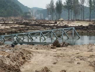
Amirsardari, A. et al. / Impact of Earthquakes on the Transportation Infrastructure of Indonesia / CED, Vol. 21, No. 1, March 2019, pp. 19–28

28. BNPB, West Sumatra and Jambi Natural Disas-                           30. Mullen, J. and Quiano, K., Death Toll in Indo-
    ters: Damage, Loss and Preliminary Needs                                  nesia Quake Rises to 35; Rescuers Search for
    Assessment. 2009, Government of Indonesia’s                               Missing, 2013 [cited 2018 1/11]; Available from:
    National Disaster Management Agency (BNPB),                               http://edition.cnn.com/2013/07/04/world/asia/indo-
    with vital input from the National Development                            nesia-earthquake/index.html.
    Planning Agency (Bappenas), the Provincial
                                                                          31. AHA Centre, The 2018 Lombok Earthquake,
    Governments of West Sumatra and Jambi, and
    International Partners.                                                   Indonesia, in Situation Update, No. 8, 2018,
29. EERI, Learning from Earthquakes: Indonesia                                ASEAN Coordinating Centre for Humanitarian
    Earthquake and Tsunami, 2010, Earthquake                                  Assistance on Disaster Management (AHA
    Engineering Research Institute (EERI).                                    Centre).

                                                                     28
You can also read