Implications of geoarchaeological investigations for the contextualization of sacred landscapes in the Nile Delta - EGQSJ
←
→
Page content transcription
If your browser does not render page correctly, please read the page content below
Research article
E&G Quaternary Sci. J., 70, 73–82, 2021
https://doi.org/10.5194/egqsj-70-73-2021
© Author(s) 2021. This work is distributed under
the Creative Commons Attribution 4.0 License.

Implications of geoarchaeological investigations for the
contextualization of sacred landscapes in the Nile Delta
Eva Lange-Athinodorou
Lehrstuhl für Ägyptologie, Julius-Maximilians-Universität Würzburg, Würzburg, 97070, Germany

Correspondence:        Eva Lange-Athinodorou (eva.lange@uni-wuerzburg.de)

Relevant dates:        Received: 2 July 2020 – Revised: 30 September 2020 – Accepted: 9 October 2020 –
                       Published: 12 February 2021

How to cite:           Lange-Athinodorou, E.: Implications of geoarchaeological investigations for the contextualization of
                       sacred landscapes in the Nile Delta, E&G Quaternary Sci. J., 70, 73–82, https://doi.org/10.5194/egqsj-
                       70-73-2021, 2021.

Abstract:              Key elements of sacred landscapes of the Nile Delta were lakes, canals and artificial basins connected
                       to temples, which were built on elevated terrain. In the case of temples of goddesses of an ambivalent,
                       even dangerous, nature, i.e. lioness goddesses and all female deities who could appear as such, the
                       purpose of sacred lakes and canals exceeded their function as a water resource for basic practical
                       and religious needs. Their pleasing coolness was believed to calm the goddess’ fiery nature, and
                       during important religious festivals, the barques of the goddesses were rowed on those waters. As
                       archaeological evidence was very rare in the past, the study of those sacred waters was mainly confined
                       to textual sources. Recently applied geoarchaeological methods, however, have changed this situation
                       dramatically: they allow in-depth investigations and reconstructions of these deltaic sacred landscapes.
                       Exploring these newly available data, the paper presented here focuses on the sites of Buto, Sais and
                       Bubastis, by investigating the characteristics of their sacred lakes, canals and marshes with respect to
                       their hydrogeographical and geomorphological context and to their role in ancient Egyptian religion
                       and mythology as well.

Kurzfassung:           Heilige Gewässer verschiedener Art, d.h. Seen, Kanäle und künstliche Becken, verbunden mit auf
                       erhöhtem Gelände befindlichen Tempelgebäuden, sind als Schlüsselelemente sakraler Landschaften
                       des Nildeltas anzusehen. Im Falle von Tempeln von Göttinnen ambivalenter, ja gefährlicher Natur,
                       wie Löwengöttinnen und allen anderen weiblichen Gottheiten, die als solche erscheinen konnten,
                       ging die Funktion heiliger Seen und Kanäle über ihren Zweck als Wasserressource für grundlegende
                       praktische und religiöse Bedürfnisse hinaus. Man glaubte, dass ihre angenehme Kühle die feurige
                       Natur der Göttin beruhigte; auf den Gewässern fuhren auch die heiligen Barken, in denen die Göttin-
                       nen bei wichtigen religiösen Festen gerudert wurden. Da man bis vor relativ kurzer Zeit kaum über
                       archäologische Belege verfügte, beschränkte sich das Studium dieser heiligen Gewässer hauptsäch-
                       lich auf Textquellen. Die in neuerer Zeit verstärkt angewandten geoarchäologischen Methoden haben
                       diese Situation jedoch dramatisch verändert und ermöglichen nun eingehende Untersuchungen und
                       Rekonstruktionen dieser heiligen Landschaften des Nildeltas. Unter Einbeziehung dieser neu verfüg-
                       baren Daten konzentriert sich die hier vorgelegte Arbeit auf die heilige Landschaft von Buto, Sais
                       und Bubastis, indem sie die Merkmale ihrer heiligen Seen, Kanäle und Sümpfe im Hinblick auf ihren

Published by Copernicus Publications on behalf of the Deutsche Quartärvereinigung (DEUQUA) e.V.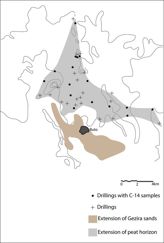
74                                                                E. Lange-Athinodorou: Sacred landscapes in the Nile Delta

                         hydrogeographischen und geomorphologischen Kontext sowie auf ihre Rolle in der altägyptischen
                         Religion und Mythologie untersucht.

1    Introduction                                                  fold watercourses and marshlands with their stagnant waters.
                                                                   Therefore, a body of water, whether in the shape of a stream,
Investigations of sacred landscapes occur at the very inter-       canal, lake or pool, connected to an elevated temple formed
section of geomorphology and archaeology, where the meth-          the basic elements of a deltaic sacred landscape.
ods and aims of both disciplines truly come together. The re-         In the past, knowledge of the existence of sacred lakes
cent increase in geoarchaeological studies at several sites in     or canals attached to or surrounding temple buildings was
the Nile Delta allows the reconstruction of important features     mainly based on religious texts with little additional archae-
of their respective palaeo-landscapes. In archaeology, the in-     ological evidence. The previously available record pointed
vestigation of landscapes and their impact on human cultural       to the existence of deltaic sacred landscapes at a number
history is well established (David and Thomas, 2016; on the        of sites. Of them, Buto (Geßler-Löhr, 1983, pp. 403–404)
different concepts of landscape in geoarchaeology cf. also         and Sais (Geßler-Löhr, 1983, pp. 233–240; Wilson, 2006,
Cordoba, 2020, p. 50).                                             2019, pp. 5, 17) in the western delta, Busiris in the central
   The study of sacred landscapes represents a special branch      delta (Geßler-Löhr, 1983, pp. 437–438), and Tanis (Mon-
of landscape archaeology, since sacred landscapes are essen-       tet, 1966; Leclère, 2008, pp. 442–443) and Bubastis (Lange-
tially landscapes that are marked and mapped with mytho-           Athinodorou et al., 2019) in the eastern delta were especially
logical references and explanations. They were sometimes           well known. At any rate, comparative studies of sacred lakes
changed due to human activities or by additions of human           are still rare (Yoyotte, 1962; Sauneron, 1964; Geßler-Löhr,
material culture. In Egyptology, the term “sacred landscape”       1983; Tillier, 2010); in particular, studies on sacred lakes as
is oftentimes used for temple complexes and their nearby sur-      elements of deltaic sacred landscapes do not exist at all.
roundings. Sometimes also waterways or land routes come               Nowadays, evidence comes from a much wider variety of
into play, as they could connect two or more temples, thus         sources. In addition to textual and archaeological records,
widening the sacred landscape. For important Egyptian re-          we have access to results of sedimentological analysis from
ligious celebrations such as the so-called Opet festival as a      core drillings, as well as from geoelectric and geomagnetic
well-known example, it was essential that the cult image of        investigations. These now allow the investigation of the lo-
the god Amun travelled on his sacred barque from his main          cation, shape or course of sacred waters at temple sites.
temple at Karnak to Luxor around 3 km to the south (Darnell,       To date however, such comprehensive, multi-methodological
2010). These travels took place on natural as well as on arti-     approaches have only been applied to a relatively small num-
ficial waterways and land routes. These were the Nile and the      ber of delta sites with well-known large-temple districts. At
canals connecting the temples to their surroundings and also       present, Buto, Sais and Bubastis are the main sites that pro-
their paved stone paths (dromoi) leading to their entrances        vide us with sufficient textual, archaeological and geoarchae-
(Geßler-Löhr, 1983, pp. 144–145; Boreik et al., 2017). Here        ological material for a comparative analysis. Therefore, they
and elsewhere, we can observe a most interesting process: at       represent the topics of the following case study, which will
first, existing natural topographical features were exploited      focus on the landscape surrounding the large temples of these
to conduct religious ceremonies. Subsequently, their require-      cities. Moreover, the local main deities of these cities all be-
ments could then initiate the addition of artificial structures    longed to the canon of the so-called dangerous goddesses; i.e.
and perhaps even the changing of the natural landscape.            they all shared specific qualities, which influenced certain el-
   Turning now from the Nile Valley to the Nile Delta, what        ements of their cults, temple buildings and their surroundings
were the main constituents of a sacred landscape there? In         as well.
the delta, temples and cemeteries were set on top of natu-
ral elevations (van den Brink, 1986, p. 12). In the eastern
delta, these were the remains of deeply eroded massive Pleis-
tocene sediments, accumulated by the vigorous Pre-Nile, the
                                                                   2   Buto
so-called geziras (Said, 1981, 1993). In the western delta,
temples were built on elevations as well, which seem to be         At Buto in the northwestern delta the sacred landscape refers
the result of different geomorphological processes, as be-         to the temple of the goddess Wadjet, the main deity of the
came clear in the case of Buto (Wunderlich, 1989). Regard-         city, who also embodied the red crown of Lower Egypt. In
less of their geomorphological origin, geziras were the dom-       this capacity, Wadjet was the northern counterpart to the god-
inant feature of the vast alluvial plain of the delta. Other       dess Nekhbet, the goddess of the white crown of Upper Egypt
distinctive characteristics of this landscape were the mani-       (Leclère, 2008, p. 198, remark no. 5).

E&G Quaternary Sci. J., 70, 73–82, 2021                                              https://doi.org/10.5194/egqsj-70-73-2021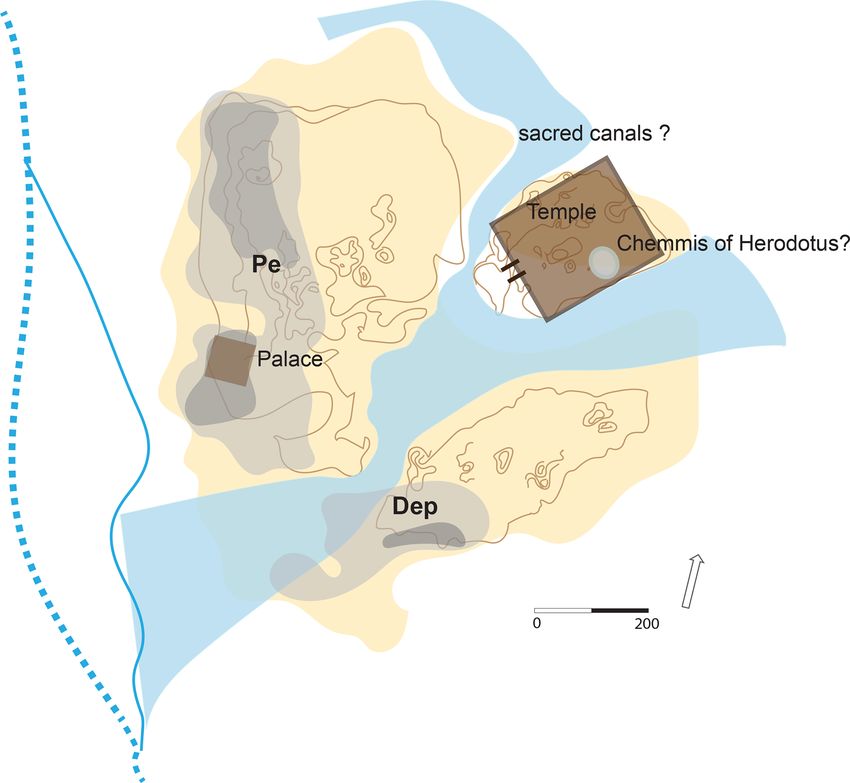
E. Lange-Athinodorou: Sacred landscapes in the Nile Delta                                                                       75

2.1   Textual sources                                             Meidum was located (cf. Yoyotte, 1962, pp. 99–101; Geßler-
                                                                  Löhr, 1983, p. 403; was it Memphis or Meidum?).
A statue dating to the Middle Kingdom from Meidum men-
                                                                     Specific information about sacred waters of the temple of
tions the goddess Wadjet with the epithet “lady of the Isheru”
                                                                  Wadjet at Buto comes from an inscription at the temple of
(Geßler-Löhr, 1983, p. 403). The Egyptian term Isheru usu-
                                                                  Mut at Karnak from the Ptolemaic Period (second–first cen-
ally designates horseshoe-shaped lakes or canals connected
                                                                  tury BCE). The text tells the story of an assemblage of the
to or surrounding temples of goddesses, who were believed
                                                                  deities of Egypt at Buto where the gods and goddesses of the
to display not only benevolent but also dangerous quali-
                                                                  Ennead are ordered to dig out a canal for Wadjet: “the gods
ties (Sauneron, 1964, pp. 50–57; Geßler-Löhr, 1983, pp. 47,
                                                                  of the Ennead, as follows: ‘you shall travel to the hill-country
401). To capture this ambivalent character, these Egyptian
                                                                  of Buto . . . were you shall dig out a canal for the mighty
goddesses were imagined to appear as lionesses, primarily
                                                                  one. You shall draw its water with both of your hands [so?]
Sekhmet, Bastet, Shesemtet and other genuinely feline god-
                                                                  her [temple?] is encircled by its canal because she is con-
desses. In addition others, e.g. Hathor, Mut, Neith, Nekhbet
                                                                  tent in the great primeval ocean”’ (Geßler-Löhr, 1983, p. 403;
and Wadjet, who usually appeared in a different, either an-
                                                                  Sauneron, 1983, p. 20, Taf. X.11–13).
thropomorphic or zoomorphic, form (Tillier, 2010, pp. 167,
                                                                     The Greek historian Herodotus (ca. 450 BCE) describes a
171–172; Lange-Athinodorou, 2019, pp. 554–561, 580–581)
                                                                  lake at this temple: “In this way the shrine is for me the most
could also be imagined as lionesses. According to their
                                                                  marvellous of all things to see in this temple; the second place
predatory nature, lionesses were feared as wild and fiery.
                                                                  has an island called Chemmis. This lies in a deep and wide
Possibly based on wildlife observations at natural water
                                                                  lake close to the temple at Buto, and the Egyptians say that
places were lions would rest, canals or lakes close to tem-
                                                                  it floats” (Hd. II. 156.1; Wilson, 2015, p. 221; Nesselrath,
ples of lioness goddesses were believed to please the god-
                                                                  2017, p. 194).
desses’ wild nature. Therefore, locations surrounded by lakes
                                                                     Thus the essential information provided by the texts is as
or canals were considered the ideal setting for their cult.
                                                                  follows:
   Still, that the inscription on the above-mentioned statue
really referred to a sacred lake or canal of the temple of          1. There was a canal at the temple(?) of Wadjet at Buto in
Wadjet at Buto is not beyond all doubt. The reason for                 order to pacify her dangerous temper.
that uncertainty is that several temples all over Egypt had
                                                                    2. There was also a lake close to the temple with a floating
lakes called Isheru where Wadjet and other goddesses ob-
                                                                       vegetated island called Chemmis.
tained subsidiary cults. The most famous Isheru lake was the
horseshoe-shaped one at the temple of Mut at Karnak. How-         Chemmis is the Greek term for the Egyptian toponym Akhbit
ever, the earliest attestations of the Isheru of the temple of    – “papyrus thicket of the bee”, with “bee” as the heraldic an-
Mut at Karnak date back to the 18th dynasty (ca. 1460 BCE).       imal designating the geographical area of the delta. Akhbit is
They are therefore much younger than the earliest records of      well known from written sources, mostly of a mythological
the term Isheru (Yoyotte, 1962, pp. 101–103, 106; Geßler-         and religious background from the time of the Pyramid Texts
Löhr, 1983, p. 412); one proof comes from a list of deities       (ca. 2350 BCE) onwards. There, it means the hiding place of
of Egypt receiving offerings from the king. Each deity is         the goddess Isis where she raised her infant son and crown
not only listed by name but also further specified by its cult    prince Horus, in order to keep the god Seth, Horus’ murder-
place. There, the lioness goddess Sekhmet bears the epithet       ous uncle, from harming him. Gardiner (1944), who inves-
“Sekhmet in Isheru”, with the name of the sacred water used       tigated all available textual references, discussed the possi-
as a toponym of its own (Mariette, 1869, T. I. Pl. 44.9). As      bility that the toponym Akhbit was used to designate not one
the text comes from the temple of Seti I at Abydos one would      but two different locations: the first site was an Akhbit in the
date it to the New Kingdom (19th dynasty, ca. 1280 BCE).          temple district of Buto, as mentioned by Herodotus. This was
However, Yoyotte (1962) and Sauneron (1964) argue that the        probably an artificial replica of the mythological hideout of
list is actually a copy from a much older template of the late    the young god Horus in the papyrus marshes, designed as a
Old Kingdom (6th dynasty, ca. 2260 BCE; Yoyotte, 1962,            vegetated island set in a sacred lake. On the other hand, ac-
p. 105; Sauneron, 1964, p. 56.4; also Geßler-Löhr, 1983,          cording to textual evidence that treats Akhbit as a real locality
p. 402). In addition, a block from the temple of Min at Koptos    and not as a specific element within the temple precinct, the
depicts Sesostris I (12th dynasty, 1919–1875 BCE) in front of     second was a natural landscape area with papyrus marshes,
the lioness goddess Bastet with the caption “Bastet, lady of      which inspired the mythos. However, this Akhbit would have
the Isheru”. Here, the use of the settlement determinative        to be localized in the vicinity of Buto as well (Gardiner, 1944,
in the writing shows again that this name was used as a to-       pp. 53–58).
ponym, yet its exact location remains unknown (Petrie, 1896,
Pl. X.2; Geßler-Löhr, 1983, p. 404; Gomàa, 1987, p. 209). In      2.2   Geoarchaeology
the light of this unique evidence, it remains impossible to de-
                                                                  At Buto, the temple of Wadjet was located at the northeast-
cide where the Isheru from the inscription on the statue from
                                                                  ern Kom B (Hartung et al., 2009, p. 184). In fact, not much

https://doi.org/10.5194/egqsj-70-73-2021                                            E&G Quaternary Sci. J., 70, 73–82, 2021
76 E. Lange-Athinodorou: Sacred landscapes in the Nile Delta
Figure 1. Topographic model of Buto with hypothetic course of the local canals at the temple. Topographic model after Hartung (2018,
p. 102, Fig. 1).
survived of this building. Apparently, an enclosure wall of dence of the former existence of a stagnant water body in this
mud bricks of ca. 300 m by 200 m encircled the temple in the area.
Late Dynastic Period. Its main entrance was on its western Still ongoing is a long-term research programme on the
side (von der Way, 1999, p. 184; Leclère, 2008, pp. 205– natural landscape of the wider area around Buto. Based on
208). Test trenches and drillings indicate the construction of core drillings and the digital and visual analysis of satellite
a foundation made of sand in the Saite Period (seventh–sixth imagery, Wunderlich (1989) detected massive peat layers to
century BCE; Faltings et al., 2000, pp. 162–165). However, the north of Buto as far as Lake Burullus, indicating the for-
when looking at the elevation model of Buto (Hartung et mer existence of a vast swampy area. These swamps origi-
al., 2009, p. 174, Abb. 27), a prominent depression between nated from a belt of semi-marine lagoons, resulting from the
the northeastern, northwestern and southern parts of the tell, marine transgression after the end of the last glacial period.
i.e. Kom A, B and C, is noticeable. One could speculate if Figure 2 shows the extension of the consolidated gezira
this almost horseshoe-shaped depression could have formed sands on which the settlement of Buto was founded and to its
a natural Isheru, presumably during the time of the inunda- north the size and limits of the peat horizon to the north as at-
tion, when depressions were probably water-bearing. tested by core drillings conducted by Wunderlich (1989). The
At any case, a definitive answer could only be expected peat horizon is the remnant of the above-mentioned semi-
from the analysis of sediments of cores taken in that area. Al- marine lagoon. C-14 datings on a number of test samples
though Hartung et al. (2009, p. 174, Abb. 27) conducted ex- from the peat horizon (location indicated in Fig. 2) show that
tensive drilling campaigns at the site, they focused mainly on the lagoon belt moved inland to up to around 2 km north of
the western stretch of the tell, leaving the area in question still Buto from 5050 to 4050 BCE. With the lowering of the sea
unexplored. Interestingly, a single core drilling conducted by level, the swamp dried up again from the fourth millennium
Faltings et al. (2000, pp. 167–168) in the eastern part of the BCE onwards (Wunderlich, 1989, pp. 106–110; Wunderlich
temple precinct revealed green-greyish clayey mud with or- and Ginau, 2014/2015, pp. 488–494).
ganic remains of plants, shells and fish bones, providing evi- Therefore, at the time of the beginning of the settlement at
Buto in the second half of the fourth millennium BCE (Falt-
E&G Quaternary Sci. J., 70, 73–82, 2021 https://doi.org/10.5194/egqsj-70-73-2021E. Lange-Athinodorou: Sacred landscapes in the Nile Delta 77
3.1 Textual sources
Some important information concerning a lake at the temple
of Neith at Sais under the reign of Amasis (570–526 BCE)
comes from a biographical inscription on the dorsal pillar of
the statue of an official named Horkhebi who states: “I dug
a lake on the eastern side of the canal ww. [Its] length: 68
cubits, width: 65[?] cubits, lined with stone, with 8 staircases
and walls around it [. . . ] in it for Neith and the gods of the
nome of Sais by order of the Dual king Amasis, son of Neith”
(Geßler-Löhr, 1983, pp. 233–235).
The inscription on the statue of a woman from the early
Ptolemaic Period usually cited in the literature amongst the
textual evidence (Leclant and De Meulenaere, 1957, p. 36;
Geßler-Löhr, 1983, p. 237; Zecchi, 1996, pp. 32–33; Wilson,
2019, p. 17) should be omitted as the reading of the group of
signs in question is unsure and might refer to the offerings
rather than to the lake.1
Herodotus describes the lake of the temple at Sais as fol-
lows: “Great stone obelisks stand in this sacred precinct, and
a lake adjoins, beautifully lined with a crepidoma of stone all
around; it is, as it seemed to me, as big as the lake at De-
los, the so-called Circular Pond” (Hd. II. 170; Wilson, 2015,
p. 228; Nesselrath, 2017, p. 200; also Wilson 2006, pp. 36–
37).
These texts bear witness to the existence of a sacred lake in
the precinct of the temple of Neith at Sais. The biographical
inscription of Horkhebi provides some details on the dimen-
sions and the location of the lake, which will be discussed
below (Sects. 3.2 and 4).
Figure 2. Geomorphology of Buto according to geophysical inves- 3.2 Geoarchaeology
tigations, by courtesy of Jürgen Wunderlich (altered after Wunder-
lich, 1989, p. 108, Abb. 33). Similar to Buto, Sais was originally a twin tell, with the set-
tlement started on two neighbouring geziras, to the west and
east of a natural canal that evolved out of a lake between the
ings, 1998, p. 373), the occupants of Buto could still explore two elevations (Wilson, 2006, pp. 203–204).
large areas with open water surfaces and a dense vegetation According to the drillings conducted by the team of Wil-
of papyrus and other helophytes. Such a natural landscape son (2006), an ancient water canal once flowed close to the
would certainly match with the idea of the mythological pa- eastern side of the so-called northern enclosure, an area to
pyrus marshes. the north of the site. In this area to the north of the site was
once located the temple of Sais, now completely destroyed.
There might have been another palaeo-canal to the east, yet
3 Sais
the traces found there indicate a more recent dating for this
Sais was the main cult place of the goddess Neith, a god- waterway (Wilson, 2006, pp. 177–204, 252–256).
dess of deltaic origins (Wilson, 2006, pp. 2–3; Wilson, 2011, On the eastern side of the northern enclosure, a possibly
pp. 186–187), who since the earliest times belonged to the natural spring still flows. It may have already existed in an-
most important female deities of Egypt. As stated above, cient times. Wilson (2006) also reports the discovery of sev-
besides her anthropomorphic image often wearing the red eral limestone blocks at the site of this spring, which might
crown of Lower Egypt, Neith could appear in the shape have belonged to the lining of the sacred lake. According to
of a fearsome lioness goddess, sometimes associated with her the spring could have been the source of the sacred lake
Sekhmet and Bastet (El-Sayed, 1982, p. 136). of the temple (Wilson, 2006, p. 256). This fits well with the
biographical text of Horkhebi cited above, who describes the
1 My thanks go to Karl Jansen-Winkeln for his helpful comments
on this text.
https://doi.org/10.5194/egqsj-70-73-2021 E&G Quaternary Sci. J., 70, 73–82, 202178 E. Lange-Athinodorou: Sacred landscapes in the Nile Delta
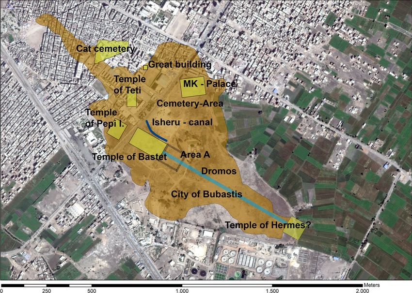
Figure 3. The course of the northern sacred canal at Bubastis according to the latest geophysical investigations. © Google Maps, modified
by Eva Lange-Athinodorou.
construction of a sacred lake at the temple, more precisely an p. 88.4; Geßler-Löhr, 1983, p. 407, footnote 1348; Meeks,
artificial water basin, lined with stone blocks and accessible 2006, pp. 100–101).
via staircases leading down to the water. Another paragraph in the same papyrus calling those wa-
ters Isheru informs us about the triumphal appearance of
Bastet as the defeater of Seth in her sacred barque during
4 Bubastis
her annual festival: “And they row her in the Oryx antelope
Attestations for the cult of Bastet date back to the second on the Isheru at the moment as she saved the Udjat-Eye from
dynasty (ca. 2850 BCE). If Bubastis was already the main him”. (pBrooklyn 47.218.84, IX.7–8; Meeks, 2006, p. 20;
cult place of this goddess in these early times is difficult to Bohms, 2013, pp. 36–42). A very vivid depiction of this
establish, as the earliest evidence of the cult of Bastet there scene appears on the fragment of a stela from the Late Period.
dates back to the sixth dynasty only (Lange, 2016, pp. 310– It was discovered at Bubastis at the cemetery of the cats, the
313). We have, however, ample textual and archaeological sacred animals of the goddess (El-Sawi, 1977). Here we find
evidence that she was the main goddess of Bubastis from all the elements described in the papyrus: the statue of the
then on until the time of the Roman emperors (Naville, 1891; goddess in her shrine sitting in a barque, the stern of which is
de Wit, 1956, pp. 292–297 ). shaped like the head of an oryx antelope, the animal of Seth,
representing the enemy she had subdued. Under the barque,
zigzag lines indicate the water of the sacred canal as well (cf.
4.1 Textual sources
also Geßler-Löhr, 1983, p. 407 and Fig. 74; Schorsch, 2015).
The sacred waters of Bubastis appear prominently in the Herodotus describes the environments of the temple of
written record. Papyrus Brooklyn 47.218.84, a mythological Bastet at Bubastis in detail: “Except the entrance, the rest
compendium on the cities of the delta from the second part of is an island. The canals, which come from the Nile, are not
the seventh century BCE, contains two references to it. The joining one another, but each one extends to the entrance of
first says about the goddess, “She is on the pedestal of ’throw- the temple; the one surrounds the one side, the other the other
ing down the enemies’. A falcon tames her, two hippo deities side and each one is 100 feet wide and shadowed by trees”
surround her, an Henet water is all around her, the length of (Hd. II. 138.1; Wilson, 2015, pp. 208–209; Nesselrath, 2017,
which is . . . 7(?) (cubits and the width) 42 (cubits)” (pBrook- p. 184).
lyn 47.218.84, IX.4; Meeks, 2006, p. 20). The term Henet The above-mentioned texts all come from the second part
that refers to the waters surrounding the temple of Bastet can of the first millennium BCE. Still, how far the Isheru at
generally designate various types of natural bodies of wa- Bubastis really dates back is unclear. The above-mentioned
ter, such as Nile branches, canals and lakes (Yoyotte, 1962,
E&G Quaternary Sci. J., 70, 73–82, 2021 https://doi.org/10.5194/egqsj-70-73-2021E. Lange-Athinodorou: Sacred landscapes in the Nile Delta 79
relief block (cf. Sect. 1.1) from the early 12th dynasty from As one can see in the case of Bubastis, Herodotus did dif-
Koptos names Bastet as the Lady of Isheru. Yet, the location ferentiate between lakes and canals thoroughly. Therefore,
of the Isheru mentioned on this block does not necessarily the two texts might actually describe two distinct sacred wa-
have to be at Bubastis, contrary to some attempts to locate ters at Buto: a probably horseshoe-shaped canal surround-
it there (Sauneron, 1964, pp. 52, footnote 33; Yoyotte, 1962, ing the temple mound and a lake within the temple enclo-
pp. 103–104). sure wall. A drilling core in the eastern part of the temenos,
south of the main axis of the temple, indicates that the sa-
4.2 Geoarchaeology cred lake could have been somewhere in this area (cf. above
Sect. 1.2). However, without further core drillings there is
Core drillings at Bubastis conducted by Ullmann et al. (2019, no way of determining its dimensions. Furthermore, no core
pp. 190, 195–197) revealed that the temple of Bastet sits on drillings, sediment analyses and geoelectric soundings are
the elevated part of a NW–SE-oriented gezira of Pleistocene available yet from the depression around the temple mound,
origin. Furthermore, it is possible that Bubastis, like Buto and where the canal of Wadjet could have flowed as described in
Sais, was actually built not only on one elevation but also on the Ptolemaic text. Its existence in that vicinity is definitely
a twin tell. In that case, the temple area was located on the a hypothesis worth testing by the means of geoarchaeolog-
southern mound, while the cemeteries were established at the ical methods in the future. Another interesting, yet admit-
northern one. tedly still unproven, possibility is that the palaeo-landscape
Recently, DCR soundings and ERT by Amr Abd el-Raouf with large marshlands to the north of Buto, as revealed by
pointed to the existence of a canal, close to the temple of the geophysical survey there (cf. Sect. 2.1), might have in-
Bastet. Core drillings and sediment analyses by Julia Meister spired the mythos of the hiding of the child god Horus by
corroborated those finds, placing a canal around 50–60 m to his mother Isis in the papyrus thickets. In this process, the
the north of the outer wall of the temple (Lange-Athinodorou natural landscape, i.e. the marshlands called Akhbit, would
et al., 2019). The results of the combined geophysical analy- have undergone a mythological interpretation and could later
sis led to the detection of around a 300 m length of a canal, on be used as an ideal model providing the scenery for this
its width measuring between 20 and 30 m (cf. Fig. 3; Lange- specific mythos in Egyptian religious texts.
Athinodorou et al., 2019). This canal was most probably the At Sais, we encounter a different situation. The texts unan-
northern part of the canal system that surrounded the temple, imously describe a sacred lake, which Herodotus reports
namely the Isheru or Henet of the Egyptian texts. was established within the temenos area. The earlier text of
The dominant infill of the canal with fine-grained sedi- Horkhebi adds its dimensions: the basin he built would have
ments as well as their high content of organic matter indicates measured 35.63 m by 34.06 m, thus forming an almost square
that very slowly flowing water accumulated them. Parallel structure. Measuring 100 m by 70 m, the lake at Delos, which
sediment laminations point to a periodic influx of fresh water, Herodotus uses for comparison, was, however, much larger
coming from a larger river, possibly a nearby Nile tributary. (Nesselrath, 2017, p. 788, no. 264).
Eventually, the canal at the temple was cut off and became More complicated is the localization of the lake with re-
stagnant water, gradually silting up (Lange-Athinodorou et gards to the canal of the name ww in Horkhebi’s inscription.
al., 2019, pp. 6–8, 11). A dating of the canal and its active At first glance, one is inclined to identify this waterway with
periods is still difficult and must await further chronological the palaeo-canal to the east of the temple area (cf. Sect. 2.2).
analysis. However, the textual sources show that the canal Yet, as Wilson (2006, p. 257) points out, this poses problems,
system was existent at least in the time from the seventh to because Horkhebi clearly states, “I dug a lake on the eastern
the fifth century BCE. side of the canal ww” (emphasis added). The eastern side of
the palaeo-canal is far outside of the temenos area. In this
5 Discussion case, the artificial lake would have been nowhere within the
enclosure wall of the temple, which seems to be very im-
The survey of the textual and geoarchaeological evidence probable. Moreover, the position of the spring, as the pos-
represented in Sects. 1.1–3.2 allows some tentative recon- sible source of the lake, can be localized to the west of the
structions and comparisons of the lakes and canals in, around palaeo-canal and hence doubtless well within the temple dis-
and nearby the temples of Buto, Sais and Bubastis with re- trict (Wilson, 2006, p. 262, Fig. 8). Therefore, the ww canal
spect to their different hydrogeographic and geomorpholog- should not be identified with the palaeo-canal to the east de-
ical contexts. In addition, I will discuss the question as to tected by core drillings. Rather, the ww canal was probably
whether the canals and lakes at those sites are of a natural or flowing somewhere to the west of the northern enclosure. The
artificial origin. canal detected in this area is however a more recent structure.
For Buto, a text from the Ptolemaic Period at Karnak More evidence is available for Bubastis: the main sacred
points to the existence of a sacred canal around the tem- body of water of the temple was doubtlessly a structure of
ple. By contrast, Herodotus refers to a “deep and wide” lake two canals coming from a Nile branch. The temple mound
with an island somewhere close to the temple (cf. Sect. 1.1). therefore must truly have given the impression of an is-
https://doi.org/10.5194/egqsj-70-73-2021 E&G Quaternary Sci. J., 70, 73–82, 202180 E. Lange-Athinodorou: Sacred landscapes in the Nile Delta land, quite as Herodotus described it. As was shown above variety of wildlife and therefore also attracted hunting lion (Sect. 3.2), one of the paragraphs of Papyrus Brooklyn pro- prides (Tillier, 2010, p. 173, footnote 46). People would ob- vides information on its dimensions: “an Henet water is all serve lionesses at those natural lakes not only hunting but around her, the length of which is . . . 7(?) (cubits and the also lovingly caring for their cubs. By analogy, people might width) 42 (cubits).” Unfortunately, the first specification in have imagined that this kind of landscape was favourable for the papyrus is illegible. The width of the canal given by the lioness goddesses as well. The water surrounding their tem- ancient texts on the other hand is very close to the facts dis- ples would cool and calm their temper and bring out their covered by the geophysical analysis: the 42 cubits of Pa- positive, caring and protective nature. Therefore, locations pyrus Brooklyn are a little more than 22 m. The description surrounded by lakes or canals would have been thought to of Herodotus states 30 m for the width instead. These differ- have been the ideal setting for their cult. ent statements of the dimensions in Papyrus Brooklyn and According to the narration of Herodotus, countless people Herodotus might be explained by the fact that the canal was celebrated festivals at Bubastis in honour of Bastet, which part of a dynamic hydrographic system. Its water level and seem to have been ecstatic and orgiastic. The celebrations dimensions therefore changed not only from season to sea- involved drunkenness and displays of many kinds of ec- son with the changing water volume of the Nile and its dis- static activities like wild dancing and singing (Hd. II. 59.1– tributaries but also on a long-term scale. In Bubastis, another 60.1; Wilson, 2015, pp. 161–162; Nesselrath, 2017, pp. 144– artificial basin might have also existed within the temple en- 145). The already cited texts of Papyrus Brooklyn include a closure such as in Buto and Sais, but to date, there is no indi- tale about Bastet, who saved the eye of Horus from Seth at cation of it. Bubastis and was rowed on the sacred canals displaying her Finally, the question arises as to whether the sacred canals triumph over the enemy (cf. Sect. 3.1). This is actually the and lakes at Buto, Sais and Bubastis were of natural or artifi- description of a river procession with a cult statue of Bastet cial origin. In the case of the canals at Bubastis, the results of in her barque shrine as the culmination of the festival. Surely, the geoarchaeological investigation do not yet allow a defini- the appearance of the triumphant goddess would be the sum- tive answer. It is, however, conceivable that the natural hy- mit of a celebration passionately attended by the thousands drogeographic situation with two canals surrounding the el- of pilgrims who journeyed to her city every year to attend her evated part of the gezira led to the founding of the temple festival. of Bastet there. The main reasons for choosing this position were very probably the specific requirements of the cult of the lioness goddess (cf. Sect. 5; also Yoyotte, 1962, pp. 108– 6 Summary and conclusions 109). In later times, people might have artificially maintained the function of the canal as a navigable waterway by digging Elemental components of sacred landscapes at Buto, Sais and out accumulating sediments on a more or less regular ba- Bubastis were the canals and lakes in close proximity to the sis. Regarding the canal around the temple mound at Buto, temples of the goddesses who were venerated in those cities. a similar situation is imaginable but awaits future investiga- Geoarchaeological investigations not only bear witness to tions as well. The temple lake at Sais might have been based their existence but also indicate their dimensions and loca- on a comparable process of enhancing a natural situation by tions and help to reconstruct the hydrogeography and palaeo- artificial means: assumedly, a natural spring in the western landscape they were connected to. So far, the analysis of the part of the temenos area was the source of water that filled data gained by geoarchaeological methods leads to interest- an artificial basin built of limestone blocks. Finally, whether ing results on the specifics of the lakes and canals at the three the sacred lake within the temple of Wadjet was in any way sites used as case studies: a sacred canal of the Isheru type similar to the one at Sais cannot be answered without further and a sacred lake within the temple enclosure most proba- data. bly defined the sacred landscape of Buto. At Sais, an exist- The question remains around which reasons might have ing sacred lake of possibly natural origin was enhanced for caused the specific connection of the horseshoe-shaped lakes continuous use with an enclosure of stone blocks. The large and canals and the temples of goddesses. One answer lies Isheru-type canals of Bubastis enclosed the temple almost in the geomorphological situation of the temple sites in the completely. delta. Here, temples were built on elevations, while the de- On the other hand, textual records are useful with regard pressions close to them would be at least seasonally water- to the understanding and reconstruction of the importance of bearing. In that case, a half-circular shape of the pool or sacred waters in the cult and the local mythology of Wadjet, canal would emerge as in the cases of Buto and Bubastis. Neith and Bastet. All of them were goddesses considered to As horseshoe-shaped lakes were preferred near temples of be of an ambivalent nature: mighty, protecting and danger- goddesses in the Nile Valley as well, several scholars ar- ous, the latter preferably to the enemies of the king; yet the gue that their natural prototypes might have been temporary rage of the goddesses could turn against even their admirers fan-shaped lakes evolving on the estuaries of the wadis after at any moment or, alternatively, into a peaceful calm temper seasonal rainfall. Such temporary lakes provided water for a (Lange-Athinodorou et al., 2019, pp. 554–561, 580–581). A E&G Quaternary Sci. J., 70, 73–82, 2021 https://doi.org/10.5194/egqsj-70-73-2021
E. Lange-Athinodorou: Sacred landscapes in the Nile Delta                                                                                  81

canal system enclosing their temple or at least a lake close to         References
the sanctuary was believed to be necessary to cool and please
their unpredictable fiery temper.
   Furthermore, the sacred canals were not only a tool to               Bohms, I.: Säugetiere in der altägyptischen Literatur, Ägyptologie
                                                                           2, Lit-Verlag, Berlin, Münster, 2013.
please and cool the mood of the goddesses; they were also
                                                                        Boreik, M., Gabolde, L., and Graham A.: Karnak’s quaysides: evo-
a key element in the performance of their cults. The rich tex-             lution of the embankments from the Eighteenth Dynasty to the
tual and pictorial evidence at Bubastis could be used as a role            Graeco-Roman Period, in: The Nile: natural and cultural land-
model of the events taking place on and around the sacred                  scape in Egypt, edited by: Willems, H. and Dahms, J.-M., tran-
waters of Buto and Sais. Although there is no comparable                   script, Bielefeld, 97–144, 2017.
textual evidence, it is well imaginable that Wadjet and Neith           Cordoba, C.: Geoarchaeology, The Human-Environmental Ap-
had festivals of their own with their barques appearing on                 proach, I. B. Tauris, London, New York, Oxford, New Delhi,
their sacred canals and lakes during religious festivals. We               Sydney, 2020.
know of such ceremonies at the temples of Sekhmet at Mem-               Darnell, J. C.: Opet festival, in: UCLA Encyclopedia of Egyptology
phis, Mut at Karnak and Hathor at Dendera to name but a                    online (1.1), edited by: Dieleman, J. and Wendrich, W., available
few (Geßler-Löhr, 1983, pp. 401–424; Tillier, 2010, pp. 170–               at: https://escholarship.org/uc/item/4739r3fr (last access: 27 June
                                                                           2020), 2010.
171).
                                                                        David, B. and Thomas, J.: Landscape archaeology: introduction, in:
   The results of the geophysical survey of the environs of                Handbook of landscape archaeology, edited by: David, B. and
Buto now widen the horizon much further. The evidence of                   Thomas, J., Routledge, New York, 27–43, 2016.
a large palaeo-swamp north of Buto leads to the question as             De Wit, C.: Le rôle et le sens du lion dans l’Égypte ancienne, E.J.
to whether human experience of this impressive landscape                   Brill, Leiden, 1951.
resulted in the concept of the papyrus marshes of Akhbit as             El-Sawi, A.: Preliminary report on Tell Basta excavations, Seasons
the hiding place of Horus, a centrepiece of Egyptian mythol-               1969, 1970, 1971, Zeitschrift für Ägyptische Sprache und Alter-
ogy. If correct, this could highlight the cognitive process of             tumskunde, 104, 127–131, 1977.
connecting natural landscapes with mythological narratives:             El-Sayed, R.: La déesse Neith de Saïs, BdE 86, Institut français
certain features of natural landscapes of the delta, even far              d’Archéologie orientale, Le Caire,1982 (in French).
from temple buildings, were incorporated into the imaginary             Faltings, D., Ballet, P., Förster, F., French, P., Ihde, C., Sahlmann,
                                                                           H., Thomalsky, J., Thumshirn, C., and Wodzinska, A.: Zweiter
sacred landscapes of the delta in ancient Egyptian minds.
                                                                           Vorbericht über die Arbeiten in Buto von 1996 bis 1999, Mit-
                                                                           teilungen des Deutschen Archäologischen Instituts, Abteilung
                                                                           Kairo, 56, 131–179, 2000 (in German).
Data availability. All relevant data and references are cited in this   Faltings, D.: Recent excavations in Tell El-Fara’in Buto: new finds
article.                                                                   and their chronological implications, in: Proceedings of the Sev-
                                                                           enth International Congress of Egyptologists, Cambridge, 3–9
                                                                           September 1995, edited by: Eyre, C. J., Peeters, Leuven, 365–
Competing interests. The author declares that there is no con-             375, 1998 (in German).
flict of interest.                                                      Gardiner, A. H.: Horus the Behdetite, Journal of Egyptian Archae-
                                                                           ology, 30, 23–60, 1944.
                                                                        Geßler-Löhr, B.: Die heiligen Seen ägyptischer Tempel: ein Beitrag
Special issue statement. This article is part of the special issue         zur Deutung sakraler Baukunst im alten Ägypten, Hildesheimer
“Geoarchaeology of the Nile Delta”. It is a result of the workshop         Ägyptologische Beiträge, 21, Gerstenberg, Hildesheim, 1983.
“Geoarchaeology of the Nile Delta: Current Research and Future          Gomaà, F.: Die Besiedlung Ägyptens während des Mittleren Re-
Prospects”, Würzburg, Germany, 29–30 November 2019.                        iches II: Unterägypten und die angrenzenden Gebiete. Beihefte
                                                                           zum Tübinger Atlas des Vorderen Orients, Reihe B (Geisteswis-
                                                                           senschaften) 66, Reichert, Wiesbaden, 1987.
Acknowledgements. I would like to thank the participants of the         Hartung, U., Ballet, P., Effland, A., French, P. G., Hartmann, R.,
workshop for an interesting discussion, as well as the anonymous           Herbich, T., Hoffmann, H., Hower-Tilmann, E., Kitagawa, C.,
reviewers for their input.                                                 Kopp, P., Kreibig, W., Lecuyot, G., Lösch, S., Marouard, G.,
                                                                           Zink, A., Nerlich, A., and Pithon M.: Tell el-Fara’in – Buto: 10,
                                                                           Vorbericht, Mitteilungen des Deutschen Archäologischen Insti-
Financial support. This open-access publication was funded by              tuts Kairo, 65, 83–190, 2009 (in German).
Julius-Maximilians-Universität Würzburg.                                Hartung, U.: Recent investigations of Early Dynastic building struc-
                                                                           tures at Tell el-Fara’in/Buto, in: Ancient Egyptian and ancient
                                                                           Near Eastern palaces, volume I: Proceedings of the conference
                                                                           on palaces in ancient Egypt, edited by: Bietak, M. and Prell, Sil-
Review statement. This paper was edited by Becky Briant and
                                                                           via, London, UK, 12–14 June 2013, 101–112, 2018.
reviewed by two anonymous referees.
                                                                        Lange, E.: The lioness goddess in the Old Kingdom Nile Delta: a
                                                                           study in local cult topography, in: Sapientia Felicitas: Festschrift
                                                                           für Günter Vittmann zum 29. Februar 2016, edited by: Lippert,

https://doi.org/10.5194/egqsj-70-73-2021                                                    E&G Quaternary Sci. J., 70, 73–82, 2021
82 E. Lange-Athinodorou: Sacred landscapes in the Nile Delta S. L., Schentuleit, M., and Stadler, M. A., CENiM, 14, 301–324, Sauneron, S.: Villes et légendes d’Égypte, Bulletin de l’Institut 2016. Français d’Archéologie Orientale (BIFAO), Cairo, 62, 33–57, Lange-Athinodorou, E.: Der “Tempel des Hermes” und die Pfeile 1964 (in French). der Bastet: zur Rekonstruktion der Kultlandschaft von Bubastis, Schorsch, D.: Bastet goes boating, Bulletin of the Egyptological in: En détail – Philologie und Archäologie im Diskurs, edited Seminar (BES), 19, 571–584, 2015. by: Brose, M., Dils, P., Naether, F., Popko, L., and Raue, D., Tillier, A.: Notes sur l’icherou, Égypte Nilotique et Méditer- De Gruyter, Berlin/Boston, Festschrift für Hans-Werner Fischer- ranéenne, 3, 167–176, 2010. Elfert 1, 549–585, https://doi.org/10.1515/9783110629705-025, Ullmann, T., Lange-Athinodorou E., Göbel, A., Büdel, C., and 2019. Baumhauer, R.: Preliminary results on the paleo-landscape of Lange-Athinodorou, E., Abd El-Raouf, A., Ullmann, T., Trappe, Tell Basta/Bubastis (eastern Nile delta): an integrated approach J., Meister, J., and Baumhauer, R.: The sacred canals of combining GIS-based spatial analysis, geophysical and archaeo- the temple of Bastet at Bubastis (Egypt): new findings logical investigations, Quatern. Int., 511, 185–199, 2019. from geomorphological investigations and Electrical Resis- van den Brink, E. C. M.: A geo-archaeological survey in the north- tivity Tomography (ERT), J. Archaeol. Sci.-Rep., 26, 1–13, eastern Nile Delta, Mitteilungen des Deutschen Archäologischen https://doi.org/10.1016/j.jasrep.2019.101910, 2019. Instituts, Abteilung Kairo, 43, 7–31, 1986. Leclant, J. and De Meulenaere, H.: Une statuette égyptienne à Dé- von der Way, T.: Buto, in: Encyclopedia of the archaeology of an- los, Kêmi 14, 34–42, 1957 (in French). cient Egypt, edited by: Bard, K. and Shubert, S. B., London, 180– Leclère, F.: Les villes de Basse Égypte au Ier millénaire av. J.-C.: 184, 1999. analyse archéologique et historique de la topographie urbaine, Wilson, N. G.: Herodoti Historiae, Oxford University Press, Ox- 2 vols. Bibliothèque d’étude 144, Institut français d’archéologie ford, 2015. orientale, Le Caire, 2008 (French) Wilson, P.: Gateway to the underworld: the cult areas at Sais, Stud- Mariette, A.: Abydos: description des fouilles exécutées sur ies in Ancient Egypt and Sudan, 24, 341–364, 2019. l’emplacement de cette ville, Librairie A. Franck; Imprimerie na- Wilson, P.: The survey of Saïs (Sa el-Hagar) 1997–2002, Egypt Ex- tionale, Paris, 1869 (in French). ploration Society, Excavation Memoir 77, Egypt Exploration So- Meeks, D. : Mythes et légendes du Delta d’après le papyrus ciety, London, 2006. Brooklyn 47.218.84, Mémoires publiés par les membres de Wilson, P.: Sais I: The Ramesside-Third Intermediate Period at l’Institut français d’archéologie orientale 125, Institut Français Kom Rebwa, Egypt Exploration Society, Excavation Memoir 98, d’Archéologie Orientale, Le Caire, 2006 (in French). Egypt Exploration Society, London, 2011. Montet, P.: Le lac sacré de Tanis, Académie des Inscriptions Wunderlich, J.: Untersuchungen zur Entwicklung des westlichen et Belles-Lettres (Extrait des Mémoires de l’Académie, Tome Nildeltas im Holozän, Marburger geographische Schriften, Mar- XLIV), Paris, 1966 (in French). burg/Lahn, Germany, 1989. Naville, E: Bubastis (1887–1889), EEF 8, London, 1891. Wunderlich, J. and Ginau, A.: Paläoumweltwandel im Raum Tell el Nesselrath, H.-G.: Herodot: Historien, Alfred Kröner Verlag, Fara’in/Buto: Ergebnisse und Perspektiven geoarchäologischer Stuttgart, 2017 (in German). Forschung, Mitteilungen des Deutschen Archäologischen Insti- Petrie, W. M. F.: Koptos, Bernard Quaritch, London, 1896. tuts Kairo, 70–71, 485–497, 2014/2015 (in German). Said, R.: The geological evolution of the River Nile, Springer Ver- Yoyotte, J.: Études géographiques, II: les localités méridionales lag, New York, Heidelberg, Berlin, 1981. de la région memphite et le “Pehou d’Héracléopolis”, Revue Said, R.: The river Nile: geology, hydrology and utilization, Perga- d’égyptologie, 14, 75–111, 1962 (in French). mon Press, Oxford, New York, Seoul, Tokyo, 1993. Zecchi, M.: A study of the Egyptian god Osiris Hemag. Archeolo- Sauneron, S.: La porte ptolémaïque de l’enceinte de Mout à Kar- gia e storia della civiltà egiziana e del vicino Oriente antico – nak, Mémoires publiés par les membres de l’Institut français Materiali e studi 1, La Mandragora, Imola, 1996. d’archéologie orientale, 107, Institut français d’archéologie ori- entale, Cairo, 1983 (French). E&G Quaternary Sci. J., 70, 73–82, 2021 https://doi.org/10.5194/egqsj-70-73-2021
You can also read