The fluvial history of Mars
←
→
Page content transcription
If your browser does not render page correctly, please read the page content below
Downloaded from http://rsta.royalsocietypublishing.org/ on September 24, 2015

                                                  Phil. Trans. R. Soc. A (2012) 370, 2193–2215
                                                                     doi:10.1098/rsta.2011.0500

                       The fluvial history of Mars
                                    BY MICHAEL H. CARR*
     US Geological Survey, 345 Middlefield Road, Menlo Park, CA 94025, USA

River channels and valleys have been observed on several planetary bodies in addition
to the Earth. Long sinuous valleys on Venus, our Moon and Jupiter’s moon Io are
clearly formed by lava, and branching valleys on Saturn’s moon Titan may be forming
today by rivers of methane. But by far the most dissected body in our Solar System
apart from the Earth is Mars. Branching valleys that in plan resemble terrestrial river
valleys are common throughout the most ancient landscapes preserved on the planet.
Accompanying the valleys are the remains of other indicators of erosion and deposition,
such as deltas, alluvial fans and lake beds. There is little reason to doubt that water
was the erosive agent and that early in Mars’ history, climatic conditions were very
different from the present cold conditions and such that, at least episodically, water
could flow across the surface. In addition to the branching valley networks, there are
large flood features, termed outflow channels. These are similar to, but dwarf, the largest
terrestrial flood channels. The consensus is that these channels were also cut by water
although there are other possibilities. The outflow channels mostly postdate the valley
networks, although most are still very ancient. They appear to have formed at a time
when surface conditions were similar to those that prevail today. There is evidence
that glacial activity has modified some of the water-worn valleys, particularly in the
30–50◦ latitude belts, and ice may also be implicated in the formation of geologically
recent, seemingly water-worn gullies on steep slopes. Mars also has had a long volcanic
history, and long, sinuous lava channels similar to those on the Moon and Venus are
common on and around the large volcanoes. These will not, however, be discussed
further; the emphasis here is on the effects of running water on the evolution of
the surface.
                     Keywords: Mars; valleys; outflow channels; running water

                                         1. Introduction

Because there are no rivers flowing on Mars today, our perception of its fluvial
history is based almost entirely on remote sensing, and particularly on the
morphology of the surface as observed in satellite imagery. Fortunately, we have
excellent coverage. Almost the entire planet has been imaged at 100 metre per
pixel resolution and substantial fractions at resolutions down to 1 metre per
pixel. In addition, we have global altimetry at a few hundred metres per pixel
and compositional data from infrared spectroscopy with spatial resolutions of a
*carr@usgs.gov

One contribution of 10 to a Theme Issue ‘River history’.

                                                2193           This journal is © 2012 The Royal Society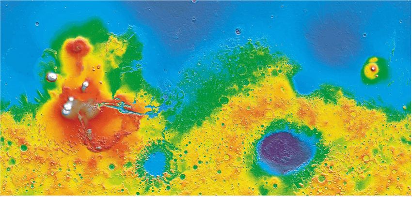
Downloaded from http://rsta.royalsocietypublishing.org/ on September 24, 2015

2194                                         M. H. Carr

                                  Table 1. Some useful Mars facts.

       orbit semi-major axis                                    1.524 AU
       inclination of rotational axis (obliquity)               25.2◦
       mean solar day                                           24 h 40 min
       year                                                     687 Earth days
       mean equatorial radius                                   3396 km
       surface elevation range                                  −8200 m to 21 230 m
       surface area                                             1.44 × 10⁸ km2
       ratio surface area to the Earth’s land area              0.976
       surface acceleration                                     3.71 m s−1
       mean atmospheric pressure at surface                     6.1 mbar (560 Pa)
       atmosphere composition                                   95.3% CO2 , 2.7% N2 , 1.6% Ar

few tens of metres. These data are supplemented by views from the ground at
several locations, particularly at the two sites explored by the rovers Spirit and
Opportunity.
   To provide some context for discussion of the fluvial features, this study begins
with a summary of present conditions on Mars and an outline of the planet’s
geological history insofar as we know it. There follows detailed discussions of
the valley networks, the large flood features and other water-worn or water-
deposited forms. Included will be brief discussions of evidence for former oceans
and speculation on the nature of the hydrological system that resulted in the
water-worn features that we see. Table 1 provides a few useful facts to aid
the discussion.

                                2. Present climatic conditions

Discovery of Mars’ branching valley networks during the Mariner-9 mission in
1972 was a complete surprise because, by that time, we already knew that Mars
had a very thin CO2 atmosphere and that the surface was much too cold to permit
streams of liquid water at the surface. At 1.5 times the Earth’s distance from the
Sun (table 1), and with almost no greenhouse effect, mean surface temperatures
are well below freezing. The mean daily temperature at the equator is close to
−60◦ C (213 K) and drops to −125◦ C (148 K) at the winter pole. During the
day, however, temperatures at the surface may fluctuate widely. At noon, they
can reach as high as 30◦ C (303 K) depending on season, location and surface
properties, although this is somewhat deceptive in that temperatures are close to
the daily mean of 60◦ below freezing just a centimetre or two below the surface.
The mean surface pressure is close to the triple point pressure for water of
6.1 mbar. Thus, at higher elevations, where the pressure is below the triple point,
ice if heated will sublime rather than melt.
   Roughly 30 per cent of the CO2 in the atmosphere freezes out in the winter
hemisphere to form a seasonal polar cap. Growth and recession of the two seasonal
caps cause movement of CO2 back and forth between the two hemispheres.
As the seasonal caps recede in summer, they expose semi-permanent water-
icecaps around 3 km thick at each pole. Water ice is also pervasive just below

Phil. Trans. R. Soc. A (2012)
Downloaded from http://rsta.royalsocietypublishing.org/ on September 24, 2015
Mars 2195
the surface at latitudes greater than 60◦ and may be present locally below
the surface at lower latitudes. Despite the widespread presence of water ice,
however, liquid water can exist near the surface only temporarily and in very small
amounts under present conditions. Widespread presence of seemingly water-worn
channels suggests therefore that climatic conditions were very different at times
in the past.
The tilt of Mars’ rotational axis (25.2◦ ) is similar to the Earth’s (23.5◦ );
so Mars, like the Earth, has seasons. Mars’ orbit has, however, a significant
eccentricity. This causes the seasons to have different lengths. At present,
southern summer (158 days) is shorter and hotter than northern summer (183
days), but the length and intensity of the seasons change slowly with time as the
various orbital and rotational parameters change. One astronomical parameter
that has a significant effect on the water cycle is the tilt of the rotational axis,
or obliquity. The Earth’s tilt undergoes little change but Mars’ obliquity changes
significantly. During the last 10 Myr, it has been as low as 15◦ and as high as 45◦ .
Laskar et al. [1] estimate that there is a 63 per cent probability that the obliquity
reached 60◦ in the last 1 Gyr. At high obliquities when the summer pole faces the
Sun, water ice sublimes from the poles and precipitates out at lower latitudes.
Warming of ice on Sun-facing slopes during high obliquities could then provide
meltwater to cut small channels.
3. Geological overview
Two-thirds of the Martian surface is heavily cratered like the surface of the
highlands on our Moon (figure 1). The surface has clearly survived from the
period of heavy bombardment that all the planetary bodies in the inner Solar
System experienced prior to around 3.7 Ga. The geological history of Mars has
been divided into three periods: the Noachian, Hesperian and Amazonian (for
a detailed summary of the geological history, see Carr [2]). The Noachian refers
to the period of heavy bombardment. The rest of the planet’s history is divided
somewhat arbitrarily into the Hesperian and Amazonian, largely on the basis
of numbers of superimposed impact craters. The absolute age of the boundary
between the Hesperian and Amazonian is not known but is estimated to be
between 2.9 and 3.3 Ga [3]. The heavily cratered Noachian terrain is mostly in
the Southern Hemisphere and is at an elevation roughly 6 km higher than the
more sparsely cratered lowlands in the north. The contrast between the two
hemispheres has been called the global dichotomy and attributed to a giant
impact very early in the planet’s history. The valley networks are mostly incised
into the heavily cratered Noachian uplands. Other than the dichotomy, the largest
surviving impact basin on the planet is Hellas, which is 4000 km across, and has
a rim that reaches 2 km above the datum and a depth that extends to 8 km
below the datum. The Hellas basin dominates drainage in the eastern part of
the Southern Hemisphere. Elsewhere, drainage is mostly controlled by the north
south regional slope created by the global dichotomy.
Much of the geological activity subsequent to the end of heavy bombardment
was related to the volcanic province of Tharsis, a broad elevated area 5000 km
across and 10 km high centred on the equator at 265◦ E (figure 1). The volcanic
pile that forms the Tharsis bulge had probably largely accumulated by the
Phil. Trans. R. Soc. A (2012)Downloaded from http://rsta.royalsocietypublishing.org/ on September 24, 2015
2196 M. H. Carr
(a) northern plains
Amazonis
Utopia
Elysium
Chryse
Olympus Mons
Tharsis
V. Marineris
Argyre
Hellas
(b)
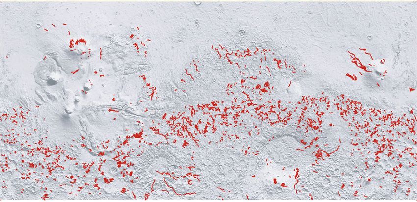
Figure 1. (a) Global topography and some of the place names mentioned in the text. The
topography is dominated by the north–south dichotomy, with high elevations in the south and low
elevations in the north, and by the presence of the Tharsis high in the west. (b) The distribution
of the larger valley networks. Most of the valleys are in heavily cratered areas, but not all heavily
cratered areas are dissected. Most of the valleys are probably water-worn, but some in the volcanic
regions of Tharsis and Elysium may have been cut by lava. (Online version in colour.)
end of heavy bombardment, as the drainage pattern of the Noachian valleys is
consistent with the present topography around the bulge. The province continued,
however, to be a focus of volcanic activity for the rest of the planet’s history.
Several volcanoes formed within the province and most of intervening plains
are characterized by numerous lava flows one upon another. The volcanoes are
enormous by terrestrial standards. The present edifice of Olympus Mons is 550 km
across, 21 km high and surrounded by a cliff up to 9 km high. Alba Patera, the
largest volcano on the planet in areal extent, is 2000 km across but only a few
kilometres high. The large size of the volcanoes has been attributed to the lack
of plate tectonics, the long life of the magma sources and the buoyancy of the
magmas. Although the present surfaces of the volcanoes have few impact craters,
Phil. Trans. R. Soc. A (2012)Downloaded from http://rsta.royalsocietypublishing.org/ on September 24, 2015
Mars 2197
which indicate that the surface is young, the volcanoes probably have been active
throughout the history of the planet, with large eruptions spaced widely in time.
Elysium, another much smaller volcanic province, is the source of several large,
seemingly fluvial, channels.
The presence of the Tharsis volcanic pile has deformed the crust and created a
vast array of radial fractures around the pile. These may have acted as conduits for
groundwater and enabled the release of groundwater to the surface. Rifting along
the radial fractures has also resulted in the formation of a vast canyon system,
the Valles Marineris. The canyons extend from the summit of the Tharsis bulge
eastward for 4000 km where they merge with some large channels. In the central
section, where several canyons merge, the depression that they form is 600 km
across and several kilometres deep. The alignment of many of the canyon walls
radial to Tharsis indicates that faulting played a major role in the formation
of the canyons, although branching side canyons and landslides show that other
processes were involved. Within the canyons are thick, layered deposits containing
hydrated sulphates. The canyons may once have contained lakes that drained
catastrophically eastwards to form the large channels with which they merge.
The deposits within canyons are mostly Hesperian in age, significantly younger
than most of the valley networks.
At each pole is a 3 km thick stack of finely layered, ice-rich deposits that extend
out roughly to the 80◦ latitude circle. The deposits are young. Crater counts
suggest 105 –107 years, with those in the south being somewhat older than those
in the north. The layering is caused by different proportions of dust incorporated
into the ice as the caps accumulated, the depositional rates being modulated
by variations in the planet’s orbital and rotational motions. The young ages are
indicative of the earlier-mentioned episodic removal of the caps during periods
of high obliquity. Dust storms are common at present during summer months,
some occasionally achieving global proportions. Drifts and dunes that are seen
in almost every high-resolution image of the surface attest to the efficacy of the
wind in moving fragmental material around the surface.
4. Valley networks
The Noachian uplands are highly eroded. Craters, the dominant landform in
the uplands, occur in widely ranging states of preservation. Some craters are
almost perfectly preserved; others, even some hundreds of kilometres across are
so filled and eroded as to be barely discernible. Clearly, the Noachian terrain has
undergone extensive erosion, with the younger craters being barely eroded and
the oldest visible craters having been almost completely eliminated. In contrast,
impact craters on post-Noachian surfaces are almost all perfectly preserved. It
appears that there were continuously high or episodically high rates of erosion
during the Noachian, and that rates fell precipitously at the end of the period,
around 3.7 Ga, then remained low for the rest of the planet’s history. Average
erosion rates during the Noachian are estimated to be around 10−6 to 10−5 m
per year, the low end of continental denudation rates on the Earth [4]. These
rates should, however, be viewed with some caution because we do not know
how old the oldest features that we can see are. According to the late heavy
bombardment model, no topographic features have survived from prior to around
Phil. Trans. R. Soc. A (2012)Downloaded from http://rsta.royalsocietypublishing.org/ on September 24, 2015 2198 M. H. Carr 3.9 Ga; in other models, some of the large basins such as Hellas may be as old as 4.4 Gyr. Average post-Noachian erosion rates were two to five orders of magnitude lower than those in the Noachian although there were episodic, local, erosional events, such as the large floods, that accomplished a significant amount of erosion. Branching valley networks, that in plan resemble terrestrial river systems, are common throughout the Noachian uplands. In view of their branching morphology, the presence of subsidiary features such as deltas, the general availability of water, at least as ice, and the lack of plausible alternatives, there is little reason to doubt that the valleys were cut by water. Most of the valley networks are incised into the degraded Noachian landscape [5–7], and one issue is the extent to which fluvial processes such as those that formed the branching valleys contributed to the general degradation. Although all the heavily cratered terrain is degraded, not all of it is dissected by valley networks. Broad areas in the Southern Hemisphere to the east and southwest of the Hellas impact basin are largely undissected, as is another large area, northwest Arabia, in the Northern Hemisphere (figure 1). Elsewhere, however, the old terrain is mostly dissected, at least at latitudes below 50◦ . Crater counts and transection relations indicate that most of the valleys formed in the late Noachian or early Hesperian. Dissection of terrains younger than lower Hesperian by branching networks is rare but has occurred locally. Some Hesperian lava plains adjacent to Echus Chasma are, for example, densely dissected by branching valleys [8] and several late Hesperian to Amazonian volcanoes (Hecates Tholus, Ceraunius Tholus, Alba Patera) have numerous valleys on their flanks. Most of the Martian valleys illustrated in figure 1 are narrow and inset into an otherwise poorly dissected terrain. They more resemble terrestrial river channels than terrestrial river valleys. The valleys are mostly 1–4 km wide and have U-shaped to rectangular cross sections downstream. Upstream they either become shallower and more V-shaped or they retain their downstream cross section until they terminate in a broad alcove. The more prominent valleys are typically incised into the surface to a depth of 50–300 m [9] and the depth of incision may remain almost constant for large distances. Typically, the more prominent valleys are outlined by steep walls with an abrupt scarp at the edge of the upland surface. Most of the valleys are less than 200 km long and drain into local depressions, but a few reach lengths of over 2000 km. Drainage densities in the Noachian terrain widely range from undissected to densely dissected local areas, with values in the 0.1–1 km−1 range [7,10]. The average drainage density for the Noachian terrain as a whole is 0.01 km−1 , two to three orders of magnitude less than typical terrestrial values. Details of the valley floors are usually masked by later deposits, particularly dunes. Irwin et al. [11] and Jaumann [12] have, however, identified a number of valleys with inner channels from which they were able to estimate stream discharges, which ranged from 300 to 5000 m3 s−1 . The rates are comparable to terrestrial rates for similar drainage areas. From the contributing areas, they derived runoff production rates of 0.1–6 cm d−1 . Jaumann [12] estimated that it would take 1800 years to cut a valley with an inner channel in the Libya Montes that they studied, but thought it more likely that the channel was cut over a much more extended period of time during episodic fluvial events. This conclusion is consistent with modelling studies of landscape development under the influence Phil. Trans. R. Soc. A (2012)
Downloaded from http://rsta.royalsocietypublishing.org/ on September 24, 2015

                                                 Mars                                       2199

                20 km

Figure 2. Warrego Vallis at 42◦ S, 267◦ E, one of the most densely dissected areas of the planet.
            The drainage density strongly supports precipitation and surface runoff.

of episodic fluvial and impact events that suggest that the incised valleys were
formed over hundreds of thousands to millions of years by multiple, modest-sized
fluvial events separated widely in time [13].
   Most of the narrow-incised valleys illustrated in figure 1 appear to have formed
in the late Noachian and early Hesperian under environmental conditions that
were fundamentally different from the earlier conditions under which crater
rims were eroded and local lows filled [6]. The younger valleys are incised
into the alluvium that fills the local depressions and, where deltas occur (see
later text), the deltas are comparable in volume to the incised valleys. There
has been minimal contribution from the areas of the drainage basins that lie
between the valleys. The period of late incision appears to have started abruptly,
ended abruptly and contributed little to the general degradation of the Noachian
landscape.
   Low drainage densities, abrupt terminations of many tributaries and the
difficulties in envisaging how early Mars could be warm enough for precipitation
and surface runoff suggested to many early researchers that the valley networks
could have formed by groundwater sapping alone [14–16]. Better imaging now
shows that the early measurements of extremely low drainage densities were due
in part to the poor resolution of the then available images. We now know that
area filling drainage is common (figure 2), although average drainage densities
are still lower than typical terrestrial values [7]. Precipitation and surface runoff
have clearly been contributors to formation of the valley networks. Nevertheless,
groundwater sapping has also likely played a role, particularly in the formation
of some prominent younger valleys such as Nirgal Vallis (figure 3) and Nanedi
Vallis, which have very open networks and tributaries with abrupt, alcove-like
terminations. In the early Hesperian, there may have been a transition from
precipitation-dominated to groundwater-controlled valley formation [17,18].
   Although dissection of plains younger than lower Hesperian is rare, several
volcanoes with surfaces that are much younger are densely dissected. It is not

Phil. Trans. R. Soc. A (2012)
Downloaded from http://rsta.royalsocietypublishing.org/ on September 24, 2015
2200 M. H. Carr
Figure 3. Nirgal Vallis at 28◦ S, 320◦ E. This is a younger valley than Warrego Vallis in figure 2.
Its more open system of tributaries and their alcove-like terminations, as seen in the inset, suggest
that groundwater sapping played a more prominent role in its formation than in the case of
Warrego Vallis.
clear whether these volcano flank valleys are similar in origin to the typical
Noachian valleys. They could have formed by mechanisms unique to volcanoes
such as erosion of pyroclastics by nuées ardentes, hydrothermal circulation of
groundwater and melting of ice, or they could be lava channels. They will not be
discussed further.
5. Drainage basins
Altimetry shows that, independent of the impact craters, the Noachian terrain
is poorly graded, having numerous closed depressions. During fluvial episodes,
these depressions presumably contained lakes. Several global-scale basins can be
extracted from the altimetry. These are not true drainage basins in the sense
that drainage paths are continuous from the divides to the basin exits, as would
normally be the case for large basins on the Earth. They do, however, show how
global drainage would converge and divide if all local lows were filled. In the
Southern Hemisphere, most of the regional drainage is towards either the Argyre
or the Hellas basins. In the Northern Hemisphere, drainage is into the northern
Phil. Trans. R. Soc. A (2012)Downloaded from http://rsta.royalsocietypublishing.org/ on September 24, 2015
Mars 2201
lowlands that form part of the hemispheric dichotomy. Despite considerable
relief along the dichotomy boundary and around Hellas, large drainage basins
analogous to the Mississippi and Amazon basins did not develop. Seemingly, the
cumulative effects of erosion, alluviation and stream capture were insufficient to
result in integration of drainage over large areas and growth of large basins. The
elimination of relief by erosion and infilling was not rapid enough to keep pace
with the creation of new relief by impacts and volcanism; so large, integrated
drainage basins did not form.
The lack of regional drainage is well demonstrated by Hellas. Despite more
than 10 km of relief between the floor of Hellas and its rim crest and despite the
area having possibly experienced 100–400 Myr of erosion during the Noachian,
there are no significant valleys draining into Hellas from the north and west.
Even if Hellas formerly contained a lake to the −3.1 km level [19], there are
still 5 km of relief from the rim crest down to the proposed lake level to
enable drainage. If the observed degradation of craters superimposed on the
rim was due to fluvial erosion, then most of the drainage must have been local,
with the water accumulating in local depressions to be lost by infiltration or
evaporation. Such a scenario is also consistent with the apparent failure to
transport large amounts of sediment from the Hellas drainage basin into the
central depression. Comparing the present topography of Hellas with the models
of the original topography suggests that the basin probably contains no more
than 2 × 10⁴ km3 of fill. The Hellas drainage basin covers 1.5 × 10⁷ km2 ; so,
despite the highly eroded craters on the rim, which imply hundreds of metres
of erosion, no more than about 1 m has been eroded from the basin rim and
transported into the basin. The sediment eroded from the highs must simply have
accumulated locally.
Quantitative measures of stream profiles and basin shapes support the
supposition that most Martian drainage basins are less well developed than
their terrestrial counterparts [20,21]. In the case of terrestrial basins, over long
time scales, relief is slowly reduced over the entire basin. Higher order streams
commonly have little relief and form alluviated plains. In most terrestrial basins,
the local slope S is approximately A−q , where A is the area upstream of the
given point and q is called the concavity exponent. The larger the upstream
area that drains through a point in a basin, the lower the slope at that point; the
higher the value of the exponent, the more concave is the basin. Terrestrial basins
typically have values that range from 0.3 to 0.7, with the smallest exponents
in basins of sporadic runoff or where groundwater sapping dominates or both.
Concavity exponents of most Martian basins are in the 0.2–0.3 range, indicating
poor concavity. Another indicator of basin shape is how the circularity of the
basin shape varies with elevation. The higher the elevation slice through a typical
terrestrial basin, the more circular the basin outline. This tendency to higher
circularities at higher elevations is significantly less pronounced with Martian
basins [22]. The low circularity is most evident in the longest streams, those that
extend from the highs on the Hellas rim, northwestward towards Chryse basin.
The poor development of basins is also reflected in the basin divides. Because
terrestrial basins tend to have significant concavity, the steepest slopes tend to
be around the periphery of a basin. In contrast, because of their low concavities,
Martian basin divides are difficult to discern in images and most can only be
determined from the altimetry [23].
Phil. Trans. R. Soc. A (2012)Downloaded from http://rsta.royalsocietypublishing.org/ on September 24, 2015
2202 M. H. Carr
6. Lakes and deltas
Lakes were probably common throughout the poorly graded Noachian terrain,
while it was undergoing fluvial erosion [24,25]. Most valleys terminate in closed
depressions such as craters or low areas between craters, where at least transient,
closed lakes almost certainly formed. Many of these areas are underlain by
seemingly fine-grained, horizontally layered, easily erodible sediments [26,27].
Chlorine-rich deposits [28] and sulphates [29] in local depressions within the
Noachian uplands may be the result of evaporation from such lakes. Lakes were
common in impact craters, as indicated by numerous crater rims breached by
ingoing and/or outgoing valleys. A prominent example is the crater Gusev in
which the Spirit rover landed. It is breached by a large channel, Ma’adim Vallis,
which itself appears to have formed by drainage of a large lake in the uplands
to the south of Gusev [30]. Many old impact craters have flat floors underlain
by finely layered sediments. A striking characteristic of many of these sediments
is their remarkably regular, rhythmic layering. The layering could result from a
variety of causes such as successive impacts and volcanic events, or changes in the
erosional regime as a result of climate change. While all these processes may have
contributed, the extreme regularity of some of the layering argues against impacts
and volcanism as primary causes. The rhythmic depositional patterns suggest
an astronomical forcing. Erosion and sedimentation may have been modulated
by climate changes that resulted from variations in the orbital and rotational
motions of the planet.
Almost 300 depressions have been identified within the highlands that have
both inlet and outlet valleys, indicating the former presence of an open basin
lake, i.e. one that overflowed [31]. In most of these lakes, the lake volume is
proportional to the watershed area, which suggests that the lakes were fed mostly
by precipitation and runoff rather than by groundwater upwelling. Modelling by
Matsubara et al. [32] suggests that the open basin lakes had rates of evaporative
loss over surface runoff comparable to lakes in the Great Basin in the western
USA. If climatic conditions were similar to the Great Basin, then the typical lake
would have had to persist for several hundred years to maintain the observed lake
levels. However, most basins are closed. From the fact that most local basins did
not overflow, coupled with estimates of peak discharges from channel dimensions
and computer simulations of fluvial erosion of cratered landscapes, Howard [13]
and Barnhart et al. [33] concluded that the valley network system did not result
from a few deluge-type events, such as might be caused by large impacts, but
rather from modest, episodic fluvial events spread over extended periods of time.
Most valleys terminate at grade in depressions with little or no indication
of deposits at their mouths, which suggests that in most cases the materials
eroded to form the valleys were either too fine-grained to form a delta or were
distributed across the depressions to form subaerial alluvial fans. Where lakes
were present, the lake levels may have fluctuated and so no delta formed. Despite
their general absence, a few tens of deltas have been recognized [11,34]. Most are
in local depressions such as craters but some that occur over a narrow elevation
range along the dichotomy boundary have been interpreted as having formed
where valleys debouch into a northern ocean [34]. The deltas typically are fan-
shaped, outlined by an outward-facing scarp and have distributary channels on
their upper surfaces (figure 4). The channels are either incised into the upper
Phil. Trans. R. Soc. A (2012)Downloaded from http://rsta.royalsocietypublishing.org/ on September 24, 2015
Mars 2203
2 km
Figure 4. This delta at 27◦ S, 326◦ E lies within a large impact crater and is at the mouth of a
valley, just off the bottom of the picture, that breached the crater rim. Differential erosion has left
remnants of distributary channels as positive features on the delta surface.
surface or left as positive features after preferential erosion of the interchannel
areas. Two particularly striking deltas are in the craters Eberswalde [35] and
Jazero (figure 5). If peak flows, estimated at 102 –103 m3 s−1 from input channel
dimensions, were continuously sustained, then both these deltas could have
formed in a few tens of years. More likely they formed by intermittent flow over
much longer periods [36–38]. The lack of deep incision of the deltas as the lake
levels declined suggests that the fluvial activity that resulted in delta formation
declined abruptly.
In summary, Mars experienced a period of fluvial incision around 3.7 Ga that
left much, but not all of the Noachian highlands dissected by branching valley
networks. Prior to that time, high erosion rates had produced a highly degraded
landscape. The branching valleys added little to that degradation. Little evidence
survives of the processes that caused the early degradation. Although water
erosion was likely involved, integration of drainage over large areas did not occur
either in the early phase or in the subsequent incision phase. During the late
incision, lakes were common throughout the Noachian, some with deltas where
streams entered. The valley and delta dimensions, coupled with lake volumes
and drainage basin areas, suggest that incision involved peak stream discharges
comparable to terrestrial rivers. The time over which most of the valleys formed
is poorly constrained. Failure to fill most closed basins suggests that the valleys
were not formed by a few deluge events but by intermittent modest-sized events,
perhaps spread over an extended period of time.
Phil. Trans. R. Soc. A (2012)Downloaded from http://rsta.royalsocietypublishing.org/ on September 24, 2015
2204 M. H. Carr
2 km
Figure 5. Delta in the 40 km Jezero crater at 19◦ N, 77◦ E. The dimensions of the channels indicate
maximum discharges of a few to several hundred cubic metres per second. The crater has an
overflow channel. Fassett & Head [38] estimate that if the calculated discharge was continuous,
then the crater would take a few tens of years to fill and overflow. They argue, however, that the
delta was more probably built with intermittent flow over thousands of years.
7. Outflow channels
Large flood channels or outflow channels are the characteristic fluvial feature of
the late Hesperian era. They are very different from the branching valley networks
just described. They have no tributaries. They start full-size from a single source,
commonly in rubble-filled depressions or at a graben. They are mostly very large,
but vary greatly in size. The largest, Kasei Vallis, is over 400 km across at its
mouth and in places over 2.5 km deep (figure 6). Others are only a few kilometres
across at their source. They have low sinuosity, smoothly curving walls and most
contain teardrop-shaped islands around which flow has diverged and converged.
On the channel floors are a range of bedforms, including longitudinal striae,
cataracts, plucked zones and inner channels. In toto, they are remarkably similar
to large terrestrial flood features, such as the Channeled Scablands of eastern
Washington State in the USA [39,40]. The size of the largest channels implies
huge discharges. Estimates for Kasei Vallis range as high as 108 –109 m3 s−1 [41,42],
when compared with 107 m3 s−1 for the Channeled Scablands [43] and a peak of
3 × 10⁴ m3 s−1 for the Mississippi. While the resemblance of some of the channels
to terrestrial flood features is impressive, a fluvial origin has been questioned.
Leverington [44], for example, argues that the channels were cut during large
eruptions of fluid lava. But the consensus is that the channels were cut by water,
based on the strong resemblance to terrestrial flood features, on the availability
of water as indicated by other indications of hydrological activity such as the
Phil. Trans. R. Soc. A (2012)Downloaded from http://rsta.royalsocietypublishing.org/ on September 24, 2015
Mars 2205
100 km
Figure 6. Kasei Vallis (25◦ N, 300◦ E), the largest outflow channel on the planet, emerges from a
shallow north–south canyon to the west of the scene shown here. To the east, the channel extends
deep into the northern plains.
valley networks, and on geophysical modelling of channel formation, as discussed
later. We will assume in the following discussion that the outflow channels were
cut by water though recognizing that there are other possibilities.
Most outflow channels formed in the late Hesperian [45], or around 3–3.5 Ga [3],
and most occur around the Chryse basin, a low area in the Northern Hemisphere
centred on 330◦ E, between the Noachian uplands of Arabia to the east and the
Tharsis rise to the west. The basin is open to the low-lying plains to the north.
The channels start in the higher ground around the basin, extend into the basin
and then northward into the low-lying, northern plains. Many of the channels
emerge full-size from closed, rubble-filled depressions (figure 7). Maja Vallis, for
example, emerges from a deep depression with an outlet 4 km above the floor
of the depression. If formed by water, then a lake must have been left in the
depression after the flood, a conclusion that is supported by the presence stacks of
layered sulphates on the depression’s floor. Other source depressions also contain
sulphate deposits. Some of the Chryse channels merge to the southeast with
the floors of the large canyons that form the eastern end of Valles Marineris.
A likely possibility is that the canyons once contained lakes that were released
catastrophically to the east to cut the channels. Again, thick sulphate deposits
and other layered sediments in the canyons support the former presence of lakes.
Elsewhere, channels start at graben. A particularly prominent example, Mangala
Vallis, several hundred kilometres long and in places over 100 km across starts
at a notch cut in a graben wall (figure 8). Another channel, Athabasca Vallis
in Elysium, that starts at a graben has an unusually young age of less than
107 years, as indicated by the number of superimposed impact craters. Several
outflow channels start adjacent to volcanoes in both of the two largest volcanic
provinces Tharsis and Elysium. Thus, outflow channels vary greatly in size, age
and geological context. What they have in common is that they start almost full-
size, with no indication of convergent surface drainage to provide their discharge.
Phil. Trans. R. Soc. A (2012)Downloaded from http://rsta.royalsocietypublishing.org/ on September 24, 2015
2206 M. H. Carr
10 km
Figure 7. Ravi Vallis (1◦ S, 316◦ E), like several other channels in the south Chryse region, emerges
from a rubble-filled depression. The floor of the depression is 1.5 km below the outlet. The channel
is thought to have formed by an eruption of groundwater. After the event, the ground collapsed
into a depression excavated by the flood to form the rubble-filled hollow that we see.
The full-size start and lack of tributaries indicate that the outflow channels
formed not by precipitation and surface runoff but by rapid release of a stored
volume of water. In the case of the channels that emerge from the eastern end
of the Valles Marineris, the stored volume was probably intra-canyon lakes.
But many of channels, particularly those around the Chryse basin, start in
rubble-filled hollows, with floors at elevations well below the elevation of the
channel floors and with volumes too small to explain the size of the channels.
Carr [46] proposed that the outflow channels that start in rubble-filled hollows
were caused by eruptions of groundwater trapped under high pressure below a
kilometres thick cryosphere. Thick aquifers, high hydrostatic pressures and high
permeabilities are needed to account for the high discharges. A kilometre thick
cryosphere is needed to contain the pressurized groundwater until containment
is breached, for example, by a large impact or a tectonic event. After the
flood, the surface collapses to form a rubble-filled hollow. The necessity of a
thick cryosphere implies that in contrast to formation of the valley networks, a
cold climate like today’s is needed to form the outflow channels. This model
has since been elaborated upon in considerable detail by Andrews-Hanna &
Phillips [47] and Hanna & Phillips [48], who suggest that tectonic forces could
have contributed to the pressurizing of the aquifer and that superlithostatic pore
pressures could cause opening of fractures within the aquifer, thereby increasing
its permeability and enabling high discharges. Hydrofracturing of the cryosphere
may also be one cause of release of water from the confined groundwater. Their
modelling results are sensitive to the aquifer properties but in a typical result
for Ares Vallis, a peak discharge of 8 × 10⁶ m3 s−1 is reached after 7 h, after
which the discharge rate drops quickly. After 23 days, 1000 km3 of water has
been released. After the flood, the path through the cryosphere would refreeze
Phil. Trans. R. Soc. A (2012)Downloaded from http://rsta.royalsocietypublishing.org/ on September 24, 2015
Mars 2207
20 km
Figure 8. Mangala Vallis (18◦ S, 210◦ E). The channel starts at a 7 km wide gap in a graben wall,
widens northward and can be traced for well over 1000 km into the northern plains.
and the aquifer, if of large areal extent, could be recharged by diffusion of
groundwater from distil sources, and the flood repeated. If this modelling is
realistic, then a large channel such as Ares Vallis, which has a volume of roughly
105 km3 , may have formed by multiple, short-lived floods, each with a far smaller
volume of water than the total volume needed to erode the channel. Another
possibility is that the flow around the channel to the surface is not restricted
by the intrinsic permeability of the fractured aquifer but instead, the aquifer
partly disintegrates and some is carried to the surface by the massive discharge,
thereby leading to collapse to form the rubble-filled hollow after the event. In
this way, larger floods would be possible and fewer would be needed to form an
Ares-like channel.
Phil. Trans. R. Soc. A (2012)Downloaded from http://rsta.royalsocietypublishing.org/ on September 24, 2015
2208 M. H. Carr
The start of the outflow channels at graben is simply explained by the
pressurized aquifer model: the faulting disrupted both the aquifer and the
cryosphere seal, thereby providing pathways for flow through the aquifer and
to the surface. Some graben, such as the Cerberus Fossae, appear to have been
the source of eruptions of both groundwater and lava, which suggests that, in
some cases, floods may not be simply triggered by tectonic activity but also by
injection of dikes [49]. Such an origin seems particularly likely for several channels
that originate in graben around the periphery of the large volcano Elysium Mons.
Eruption of groundwater along the large faults that formed the equatorial canyons
may also be the cause of the lakes that are postulated to have been formerly
present within the canyons.
The source of the water in the aquifers is uncertain. Much of it may have been
inherited from the earlier era, represented by the valley networks, when warm
surface conditions permitted precipitation and infiltration. As surface conditions
changed, water involved in the earlier hydrological cycle may have become
trapped beneath the growing cryosphere. Alternatively, or in addition, water
could have been added from primary magma sources beneath the volcanic regions
of Tharsis and Elysium. Other possibilities are that aquifers were recharged by
basal melting of ice deposits at the poles [50] or melting of ice deposits that
formed in Tharsis during periods of high obliquity [51].
8. Oceans
We saw earlier that abundant evidence of surface runoff during the Noachian
suggests that large bodies of water may have been present at that time, at least
episodically, both as sources and sinks. A number of linear features around the
northern plains [52] and in Hellas [19] have been suggested as possible shorelines,
as have the presence of deltas at similar elevations [34]. The ages of many of the
proposed shorelines are uncertain but some in the uplands could be Noachian.
However, the linear features, being discontinuous, at varying elevations, and being
open to other interpretations are not compelling evidence of former oceans. Nor
are oceans necessary for precipitation. The valley networks may have formed
by the melting of ice driven from the poles during periods of high obliquity,
or they could result from precipitation of water injected into the atmosphere
during large impacts [53]. In addition, we saw earlier that large drainage basins
with large streams to carry surface runoff into the major basins did not develop.
If large bodies of water were present in low areas such as Hellas, then they were
probably fed by groundwater. The evidence for oceans is thus equivocal. While the
simplest explanation of the high erosion rates and abundance of valley networks
in the Noachian is that conditions were Earth-like and that evaporation from
ocean-like bodies of water was in quasi-equilibrium with precipitation, runoff and
infiltration, other scenarios are possible.
The evidence for post-Noachian oceans is perhaps somewhat more convincing.
Large outflow channels drain into the northern plains. If the channels were each
eroded by a single or a few large events, then large volumes of water must once
have been present in the northern plains. Linear features on Hesperian surfaces
around the northern plains are better preserved than the Noachian ones because of
the low Hesperian erosion rates. Ghost craters in low parts of the northern plains
Phil. Trans. R. Soc. A (2012)Downloaded from http://rsta.royalsocietypublishing.org/ on September 24, 2015
Mars 2209
Figure 9. Gullies on the south facing slope of Nirgal Vallis (figure 3). The gullies, around 10 m
across, are common on pole-facing slopes in the southern uplands. The parallel linear ridges at the
bottom of the image are dunes on the valley floor.
suggest the presence of effluent deposited during the floods [54]. Many landforms
in the lower areas of the northern plains have been compared with terrestrial
features that form by meltwater under a static ice sheet [55] that could have been
a frozen remnant of an ocean. There are thus several lines of evidence suggestive
of the former presence of large bodies of water. On the other hand, if Andrews-
Hanna & Phillips [47] are correct and individual flood volumes are much smaller
than the channel volumes, then large bodies of water need not have been present.
So, we are left with similar ambiguities as with the Noachian.
9. Gullies
Gullies are by far the most common fluvial feature that has formed in the last
few billion years of Martian history. They are common on steep slopes in the
30–60◦ latitude belts with a preference for poleward facing slopes (figure 9).
They typically consist of an upper theatre-shaped alcove that tapers downslope
to converge on a channel that extends further downslope to terminate in a debris
fan [26,27]. The channels are mostly several metres wide and hundreds of metres
long. Their origin is controversial. Although initially attributed to groundwater
seeps, this origin now seems unlikely, given the probable thick cryosphere during
the second half of Mars’ history and the common presence of gullies at locations
Phil. Trans. R. Soc. A (2012)Downloaded from http://rsta.royalsocietypublishing.org/ on September 24, 2015
2210 M. H. Carr
where groundwater is unlikely, as on slopes around mesas and central peaks and
at crater rim crests. Dry mass-wasting may contribute to their formation, but
this also seems to be an unlikely cause because many of the gullies cut through
bedrock ledges. Erosion by wind or ice appears ruled out by their morphology,
and erosion by liquid or gaseous CO2 appears ruled out by stability relations.
All the morphological attributes are consistent with water erosion, and the broad
consensus is that that is their cause.
In the southern highlands at mid-latitudes, where most of the gullies occur,
average daily summer temperatures are in the 220–230 K range and surface
pressures are below the triple point of water. While groundwater seeps might
temporarily exist under such conditions, particularly in the presence of salts,
accumulation of sufficient liquid to erode gullies is unlikely. One possibility is that
the gullies result from the temporary presence of water produced by the melting
of snow and ice deposited at mid-latitudes during periods of high obliquity [56].
Such an origin is supported by modelling studies [57,58] and by observations of
gullies emerging from beneath what appear to be ice deposits on steep slopes.
The age of the gullies cannot be accurately determined, but they probably have
been forming episodically, when obliquities were high enough, throughout the last
3 Gyr and possibly longer. They appear fresh because of the extremely low erosion
rates, but are unlikely to have been forming continuously because there is little
evidence that they have caused significant backwasting of slopes and filling of
the craters, despite the long times over which they probably have been forming.
Thus, fluvial activity during the last 3 Gyr of Mars’ history has been minor,
and restricted mainly to rare groundwater eruptions, very rare valley network
formation of unknown causes and the gullying of steep slopes, probably from
melting of ice during high obliquities.
10. Global implications
The relatively high erosion rates and presence of valley networks imply that
during the Noachian, Mars was at least episodically warm and wet. This
conclusion is supported by the surface mineralogy. Widespread presence of
phyllosilicates in Noachian terrains [29,59] indicates weathering under warm,
moist conditions. In contrast, in the Hesperian, erosion rates are extremely
low and valley networks are rare. The characteristic erosional feature of the
Hesperian is the outflow channel, many of which probably formed by eruptions
of groundwater from below a thick cryosphere. Phyllosilicates are not found in
the late Hesperian terrains but evaporitic minerals, particularly sulphates, are
common. All the evidence points to a period of transition in the late Noachian–
early Hesperian time period (figure 10). Temperate conditions prevailed when
valley networks were forming in the late Noachian, but a thick cryosphere had
developed by the late Hesperian when most of the outflow channels formed.
Andrews-Hanna & Lewis [60] used global-scale hydrological models to explore
what might have happened during this transitional period. They suggest that
during the Noachian, water was abundant, warm conditions prevailed and
precipitation kept the near-surface close to saturation. However, loss of water as
a result of large impacts and solar wind interactions resulted in a lowering of the
groundwater table, precipitation became more rare but groundwater upwellings
Phil. Trans. R. Soc. A (2012)Downloaded from http://rsta.royalsocietypublishing.org/ on September 24, 2015
Mars 2211
Earth Mars Ga
0
Phanerozoic
episodic formation
0.54 and removal of polar
deposits
valley networks
extremely rare very low erosion
and weathering rates
Proterozoic Amazonian rare floods episodic glaciation
episodic gully formation
2.5
Archean 3.0 sulphur-rich intra-canyon lakes
large floods seas? deposits
Hesperian
3.7 canyon formation
heavy valley networks hydrous
Noachian bombardment high
ephemeral lakes weathering erosion rates
Hadean 4.1 Hellas oceans?
Pre-Noachian
4.5 global dichotomy
Figure 10. Comparison of geological time scales on the Earth and Mars. The timing of water-related
activity on Mars indicates major changes from the late Noachian through the Hesperian as Mars
changed from an era of high erosion rates, widespread fluvial activity and widespread aqueous
weathering, to one characterized by minimal fluvial activity, massive floods and accumulation of
sulphate-rich deposits. Around 3 Ga, the main flood-sulphate era was over and Mars entered its
present phase of extremely low erosion rates and rare fluvial activity other than gully formation.
driven by topographic variations occurred locally. Their modelling demonstrates
that the preferred locations for upwellings are those places where sulphates
are found, such as Meridiani Planum where the rover Opportunity landed. The
upwellings presumably created local lakes, which, on evaporation, left behind the
sulphate deposits that we observe. Further cooling and additional water losses
led to more lowering of the global groundwater table and ultimately trapping of
groundwater beneath a thick cryosphere.
A major issue is how Noachian Mars became warm and wet. The geological
evidence for an early warm, wet Mars is compelling yet how such conditions
were achieved is very unclear. According to stellar evolution models, 3.8 Ga
the luminosity of the Sun was 75 per cent of its present value [61]. This
would imply a mean surface temperature on Mars of 196 K if there were no
greenhouse warming [62]. Achieving the warming necessary to bring the mean
surface temperature up to 273 K would require that the atmosphere intercept 85
per cent of the radiation from the surface when compared with 56 per cent for
the Earth [62]. A very powerful greenhouse is needed.
Until the 1970s, the early atmospheres of the Earth and Mars were thought
to be reducing. If so, then several greenhouse gases (CH4 , NH3 , H2 S, H2 O) could
have provided the necessary warming. It is now thought, however, that early core
formation and massive loss of hydrogen left both the mantle and atmosphere
oxidized [63–65], and the atmosphere dominated by CO2 and H2 O. With the low
early solar luminosity and as a result of cloud formation, it may not be possible
Phil. Trans. R. Soc. A (2012)Downloaded from http://rsta.royalsocietypublishing.org/ on September 24, 2015
2212 M. H. Carr
to warm the Martian surface higher than about 230 K, with just a CO2 /H2 O
atmosphere, no matter how thick it is [66]. In addition, with Mars’ low gravity,
it is difficult to retain a thick atmosphere against blow-off by large impacts [67]
and a warm CO2 /H2 O atmosphere tends to self-destruct by forming carbonates.
Carbonates are detected at the Martian surface, although not in the amounts
expected from a massive CO2 /H2 O atmosphere.
There is thus considerable uncertainty. One possibility is that episodic, massive
volcanic events introduced large amounts of CO2 , SO2 and possibly other
greenhouse gases into the atmosphere [68]. This resulted in temporary warmings,
melting of water ice and initiated hydrological cycles. The warm conditions ended
when the strong greenhouse gases were flushed out. Another possibility is that
temporary warm conditions with accompanying rainfall were episodically caused
by large impacts [53]. But both these hypotheses have many unresolved issues.
How early Mars became warm enough to allow widespread fluvial erosion remains
a mystery.
One final mystery concerns life. Conditions on early Mars appear to have been
Earth-like. We know that life started early on the Earth, although exactly when
is still controversial [69,70]. Even if some form of life did start on early Mars, its
unambiguous detection will be difficult, as exemplified by the controversy over
the Martian meteorite ALH84001 [71,72]. Nevertheless, as in situ analyses become
more sophisticated and return of samples carefully selected for their habitability
and preservation potential becomes more feasible, the answer to whether some
form of life ever started on Mars may not be that far in the future.
References
1 Laskar, J., Correia, A., Gastineau, F., Joutel, F., Levrard, B. & Robutel, P. 2004 Long term
evolution and chaotic diffusion of the insolation quantities of Mars. Icarus 170, 343–364.
(doi:10.1016/j.icarus.2004.04.005)
2 Carr, M. H. 2006 The surface of Mars. Cambridge, UK: Cambridge University Press.
3 Hartmann, W. K. & Neukum, G. 2001 Cratering chronology and the evolution of Mars. In
Chronology and evolution of Mars (eds R. Kallenbach, J. Geiss & W. Hartmann), pp. 165–194.
Dordrecht, The Netherlands: Kluwer.
4 Golombek, M. P. et al. 2006 Erosion rates at the Mars exploration rover landing sites and
long-term climate change on Mars. J. Geophys. Res. 111, E12S10. (doi:10.1029/2006JE002754)
5 Carr, M. H. 1995 The Martian drainage system and the origin of valley networks and fretted
channels. J. Geophys. Res. 100, 7479–7507. (doi:10.1029/95JE00260)
6 Howard, A. D., Moore, J. M. & Irwin III, R. P. 2005 An intense terminal epoch of widespread
fluvial activity on Mars: 1. Valley network incision and associated deposits. J. Geophys. Res.
110, E12S14. (doi:10.1029/2005JE002459)
7 Hynek, B. M., Beach, M. & Hoke, M. R. 2010 Updated global map of Martian valley
networks and implications for climate and hydrologic processes. J. Geophys. Res. 115, E09008.
(doi:10.1029/2009JE003548)
8 Mangold, N., Quantin, C., Ansan, V., Delacourt, C. & Allemand, P. 2004 Evidence for
precipitation on Mars from dendritic valleys in the Valles Marineris area. Science 305, 78–81.
(doi:10.1126/science.1097549)
9 Williams, R. J. & Phillips, R. J. 2001 Morphometric measurements of martian valley networks
from Mars Orbiter Laser Altimeter (MOLA) data. J. Geophys. Res. 106, 23 737–23 751.
(doi:10.1029/2000JE001409)
10 Irwin, R. P., Howard, A. D. & Craddock, R. P. 2008 Fluvial valley networks on Mars. In River
confluences, tributaries, and the fluvial network (eds S. Rice, A. Roy & B. Rhoads), pp. 409–430.
Chichester, UK: Wiley.
Phil. Trans. R. Soc. A (2012)Downloaded from http://rsta.royalsocietypublishing.org/ on September 24, 2015
Mars 2213
11 Irwin, R. P., Craddock, R. A. & Howard, A. D. 2005 Interior channels in Martian valley
networks: discharge and runoff production. Geology 33, 489–492. (doi:10.1130/G21333.1)
12 Jaumann, R. 2005 Martian valley networks and associated fluvial features as seen by the Mars
Express High Resolution Camera (HRSC). In Lunar Planet. Sci. Conf. XXXVI, abstract 1815.
Houston, TX: Lunar and Planetary Institute.
13 Howard, A. D. 2007 Simulating the development of Martian highland landscapes through the
interaction of impact cratering, fluvial erosion, and variable hydrologic forcing. Geomorphology
91, 332–363. (doi:10.1016/j.geomorph.2007.04.017)
14 Pieri, D. C. 1976 Distribution of small channels on the Martian surface. Icarus 27, 25–50.
(doi:10.1016/0019-1035(76)90182-2)
15 Carr, M. H. & Clow, G. D. 1981 Martian channels and valleys: their characteristics, distribution
and age. Icarus 48, 91–117. (doi:10.1016/0019-1035(81)90156-1)
16 Goldspiel, J. M. & Squyres, S. W. 2000 Groundwater sapping and valley formation on Mars.
Icarus 148, 176–192. (doi:10.1006/icar.2000.6465)
17 Harrison, K. P. & Grimm, R. E. 2005 Tharsis recharge and the martian outflow channels:
observations and recent modeling. In Lunar Planet. Sci. Conf. XXXVI, abstract 1211. Houston,
TX: Lunar and Planetary Institute.
18 Harrison, K. P. & Grimm, R. E. 2005 Groundwater-controlled valley networks and the decline
of surface runoff on early Mars. J. Geophys. Res. 110, E12S16. (doi:10.1029/2005JE002455)
19 Moore, J. M. & Wilhelms, D. E. 2001 Hellas as a possible site of ancient ice-covered lakes on
Mars. Icarus 154, 258–276. (doi:10.1006/icar.2001.6736)
20 Aharonson, O., Zuber, M. T., Rothman, D. H., Schorghofer, B. & Whipple, K. X. 2002 Drainage
basins and channel incision on Mars. Proc. Natl Acad. Sci. USA 99, 1780–1783. (doi:10.1073/pn
as.261704198)
21 Stepinski, T. F. & O’Hara, W. J. 2003 Vertical analysis of martian drainage basins. In Lunar
Planet Sci. Conf. XXXIV, abstract 1659. Houston, TX: Lunar and Planetary Institute.
22 Stepinski, T. F. & Coradetti, S. 2004 Comparing morphologies of drainage basins on
Mars and Earth using integral-geometry and neural maps. Geophys. Res. Lett. 31, L15604.
(doi:10.1029/2004GL020359)
23 Grant, J. A. & Parker, T. J. 2002 Drainage evolution in the Margaritifer Sinus region of Mars.
J. Geophys. Res. 107, 5066. (doi:10.1029/2001JE001678)
24 Cabrol, N. A. & Grin, E. A. 1999 Distribution, classification and ages of martian impact crater
lakes. Icarus 142, 160–172. (doi:10.1006/icar.1999.6191)
25 Cabrol, N. A. & Grin, E. A. 2010 Lakes on Mars. Amsterdam, The Netherlands: Elsevier.
26 Malin, M. C. & Edgett, K. S. 2000 Sedimentary rocks of early Mars. Science 290, 1927–1937.
(doi:10.1126/science.290.5498.1927)
27 Malin, M. C. & Edgett, K. S. 2000 Evidence for recent groundwater seepage and surface runoff
on Mars. Science 288, 2330–2335. (doi:10.1126/science.288.5475.2330)
28 Osterloo, M. M., Hamilton, V. E., Bandfield, J. L., Glotch, T. D., Baldridge, A. M., Christensen,
P. R., Tornabene, L. L. & Anderson, F. S. 2008 Chloride bearing materials in the southern
highlands of Mars. Science 319, 1651–1654. (doi:10.1126/science.1150690)
29 Bibring, J.-P., Langevin, Y., Mustard, J. F., Poulet, F., Arvidson, R., Gendrin, A., Gondet, B.,
Mangold, N. & the OMEGA Team. 2006 Global mineralogical and aqueous Mars history derived
from OMEGA/Mars Express data. Science 312, 400–404. (doi:10.1126/science.1122659)
30 Irwin, R. P., Maxwell, T. A., Craddock, R. A. & Leverington, D. W. 2002 A large paleolake basin
at the head of Ma’adim Vallis, Mars. Science 296, 2209–2212. (doi:10.1126/science.1071143)
31 Fasset, C. I. & Head, J. W. 2008 Valley network-fed, open-basin lakes on Mars: distribution
and implications for Noachian surface and subsurface hydrology. Icarus 198, 37–56.
(doi:10.1016/j.icarus.2008.06.016)
32 Matsubara, Y., Howard, A. D. & Drummond, S. A. 2011 Hydrology of early Mars: lake basins.
J. Geophys. Res. 116, E04001. (doi:10.1029/2010JE003739)
33 Barnhart, C. J., Howard, A. D. & Moore, J. M. 2009 Long term precipitation and late stage
valley network formation: landform simulation of Parana Basin, Mars. J. Geophys. Res. 114,
E01003. (doi:10.1020/2008JE003122)
Phil. Trans. R. Soc. A (2012)You can also read