Chronology and Physical Evolution of Planet Mars
←
→
Page content transcription
If your browser does not render page correctly, please read the page content below
hartmann   16-12-2005    10:40    Pagina 211

                                                                                           211

                   Chronology and Physical Evolution of
                               Planet Mars

                         W.K. Hartmanna, D. Winterhalterb and J. Geissc
                          a
                           Planetary Science Institute, Tucson, Arizona, USA
                      b
                        Jet Propulsion Laboratory, Pasadena, California, USA
                     c
                      International Space Science Institute, Bern, Switzerland

           Introduction

           About half the size of Earth, Mars has desert landscapes coloured red by the rust-
           ing of iron-bearing minerals, similar to those of America’s southwestern deserts.
           As early as 1800, telescopes showed polar ice caps and shifting clouds, and the
           idea of a distant Earth-like planet began to emerge. Further studies showed
           streaky markings and dusky patches that darken and lighten during a Martian
           year. Astronomers realized that Mars is colder than Earth, since it is farther from
           the Sun, but many thought that the changing markings must be vegetation. By
           the 1880s, the Italian Giovanni Schiaparelli drew the streaks as an enigmatic net-
           work of narrow straight lines, which he called “canali.” The nature of these
           streaks caused much discussion.

           Around 1895, the colorful American astronomer Percival Lowell offered a new
           theory to explain the observations. Lowell started his argument by noting cor-
           rectly that Mars itself had evolved. Any initial thick atmospheric gases, such as
           water vapour, would have slowly leaked off into space because of Mars’s low
           gravity, causing the current air to be thin and dry. In spite of these losses, said
           Lowell, Mars was an abode for life. Not only was there vegetation, but also civ-
           ilization! Much of the vegetation was cultivated crops. Lacking water, the
           Martians had built a system of canals to bring water from polar ice caps across
           the arctic plains to the warmer equator, where the Martians lived. The streaky
           markings, which Schiaparelli and Lowell both perceived as straight lines, were
           bands of vegetation – crops – being grown along the sides of the canals.

           Lowell’s theory electrified the public for decades – but it had the scientific draw-
           back of being completely wrong. As early as the 1920s, astronomers accumu-
           lated evidence that the Martian air is even thinner and drier than Lowell thought,
           and that his straight-line canals were only streaky alignments of dusky patches.

           The Solar System and Beyond: Ten Years of ISSI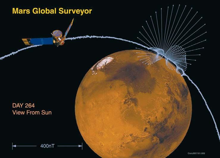
hartmann   16-12-2005    10:40   Pagina 212

           212                    W.K. Hartmann, D. Winterhalter & J. Geiss

           The pendulum of Martian theory swung much farther from Lowell’s scenario in
           1965 when Mariner 4 returned the first close-up snapshots during a quick flyby.
           These few fuzzy images showed no cities or canals, but rather moon-like craters.
           Analysts concluded that Mars is merely a Moon-like world with a little air to
           blow the dust around.

           The Early Space Missions – Volcanoes, Riverbeds, and
           Sterile Soil

           The first-ever orbital mapping of the entire planet, by Mariner 9 in 1971-1972,
           revealed that the dusky markings and Lowellian canals were patches and streaks
           of dust, oriented according to prevailing winds. Mariner 9 found volcanoes, lava
           flows, sand dunes, layered sediments, canyons, polar ice, craters, fractures,
           clouds, and fogs. The highest volcano, named Olympus Mons (Mt. Olympus,
           after the mountain that supposedly housed the Greek gods), towers some 25 km
           above the mean Martian surface. Still more astounding, Mariner 9 found this
           dusty planet, with no known liquid water, to be laced with dry riverbeds.

           Now the scientific pendulum swung back to questions that still dominate
           Martian science today. How could a frozen, desert planet once have had rivers?
           How long ago did the water flow and where did it go? Were earlier conditions
           more Earth-like? Could life have started there after all?

           The first three successful landers on Mars shed some light on these issues. On
           20 July 1976 – seven years to the day after Apollo 11 astronauts put the first human
           footprints on the Moon – Viking 1 became the first human-built device to land
           safely on Mars and send back data. Viking 2 followed a few weeks later, landing
           on a similar, but more northerly plain called Utopia. Pathfinder and its small rover,
           Sojourner, landed at the mouth of the Ares Vallis river channel in 1997. The mis-
           sion of these landers was to take the first surface photos, analyze the Martian soil
           and rocks, and look for life. Pictures at all three sites showed beautiful but barren
           desert landscapes with scattered rocks and dunes. The soils turned out to be ster-
           ile, with no organic molecules (to an accuracy of a few parts per billion). Modest
           abundances of sulphates and salts in the soils suggested that they might have been
           exposed to salty water that evaporated. No compelling evidence for life was
           found. The soils did show some curious chemical reactions when exposed to nutri-
           ents, but chemists concluded that these reactions were caused not by life, but by
           unusual soil chemistry, due to exposure of the soil to the Sun’s ultraviolet radia-
           tion. Pathfinder showed the rocks to be essentially basalts and other igneous rocks.
           The harsh surface conditions and lack of surface organics convinced most scien-
           tists by the late 1970s that no life currently exists on the Martian surface.
hartmann   16-12-2005    10:40    Pagina 213

                                 Chronology and Physical Evolution of Planet Mars                 213

           Figure 1. A global map of Mars compiled from the Mars Global Surveyor Laser Altimeter data
           (Courtesy NASA, JPL, MOLA Science Team). Visible is the dichotomy, with one hemisphere
           dominated by low plains and the other by higher, ancient cratered uplands. The colour scale
           depicts elevation referenced to some standard, with dark blue being the lowest elevations.

           On a planetary scale, the most striking geological feature found by the early mis-
           sions is the Martian crustal dichotomy1 (Fig. 1). Its boundary can be roughly
           described as a great circle inclined ~35º to the equator2. Plains to the north of
           the boundary are typically younger and smoother than the ancient, heavily
           cratered uplands to the south. Recently, data from the Mars Global Surveyor
           (MGS) has shown the dramatic difference in elevation between the two hemi-
           spheres, as much as 6 km in some areas3. The crustal dichotomy is indicative of
           a significant event or series of events, early in the history of Mars, one that has
           had a fundamental influence on the subsequent evolution of the interior and sur-
           face. Determining the origin of the dichotomy is still a problem to be solved.

           Chronologies of the Three Worlds: Earth, Moon and Mars

           Martian observations indicate not only ancient, heavily cratered uplands, but
           also sparsely cratered plains, flows of young lavas, dry river channels in varying
           states of preservation, finely layered, nearly uncratered polar deposits, tectonic
           fractures cutting through sparsely cratered plains, and other such features. One
           important factor in understanding the development of the planet is to gain at least
           a crude understanding of not just the relative ages, but also the absolute ages of
           these various geological units. A time scale is necessary to answer fundamental
           questions such as: When was the most recent volcanism? How long ago did
           Martian rivers flow? Were there repeated major fluvial periods? How much
           water and other gases have escaped into space, how much underground ice is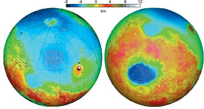
hartmann   16-12-2005      10:40    Pagina 214

           214                       W.K. Hartmann, D. Winterhalter & J. Geiss

           Figure 2. North-western region of the lunar front side with three important time markers: the date
           of the impact excavating the Imbrian Basin 3850 My (million years) ago and the age of the basalts
           in Mare Imbrium at 3300 My were obtained from Apollo 15 and 16 sample analyses4,5.
           Radiometric ages were obtained for the geological areas around all Apollo landing sites and also
           around the areas of Luna sample-return missions. An age for the crater Copernicus of about
           ~900 My was obtained from analyses of glass pieces collected not in the immediate vicinity of the
           crater, but 400 km away at the Apollo 14 landing site. The age of the glass pieces is correct, but
           their assignment to the Copernicus crater should be confirmed.

           still there, and what is the relative importance of geothermal heating versus cli-
           matic change in the episodes when it was released as liquid water?

           The history of terrestrial geology and lunar science shows that a reliable time
           scale is the backbone of the geosciences. In the 19th century, a worldwide rela-
           tion was found between fossil species and sedimentary rock strata on Earth.
           This established a chronology of geologic epochs from the Cambrian to the pres-
           ent, forced recognition of a very ancient age for the Earth, and led to the con-
           cepts of geological and biological evolution. The discovery of radioactivity at
           the end of the 19th century paved the way for establishing Earth’s absolute
           chronology, covering the Precambrian in addition to the classical epochs from
           the Cambrian to the Quaternary.

           On Mars and the Moon, relative time scales are based not on fossils, but on
           stratigraphy and surface features, in particular on the density of impact craters.
           In the case of the Moon, the cratering chronology is calibrated with the radio-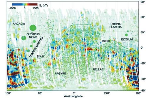
hartmann   16-12-2005      10:40    Pagina 215

                                   Chronology and Physical Evolution of Planet Mars                       215

           metric ages of lunar samples collected and documented by the Apollo astronauts
           and Soviet sample-return probes, at known landing sites (Fig. 2). The best-cal-
           ibrated epoch in lunar history is from ~4100 to ~3100 million years (My) ago,
           when the large lunar basins were excavated and then filled with mare basalts4,5.

           Chronology of Mars

           For Mars, three main geological epochs have been defined by measuring densi-
           ties of impact craters (number/km2) from photography obtained by orbiting
           spacecraft6. In the absence of Martian samples with documented geographic ori-
           gin, the Martian time scale is calibrated by comparison with the lunar time scale,
           taking into account theoretical estimates of the difference in cratering rates
           between the Moon and Mars7. At the ISSI workshop on “Chronology and
           Evolution of Mars”4 in February 1999, existing methodology and models rele-
           vant to this absolute crater-based Martian chronology were discussed and com-
           pared7-9, and a consensus was reached on a time scale for the Martian crater
           chronology. Figure 3 shows the assigned ages of the Martian geologic epochs as
           a function of numbers of craters larger than 1 km on units of various stratigraph-

           Figure 3. Mars cratering chronology model of Hartmann and Neukum8. N(1), the crater density
           of all craters larger than 1 km, is plotted against inferred age. The two curves are derived with
           slightly different assumptions. The diagram shows estimated ages of Martian geological epochs.
           Grey bands give the uncertainties due to the difference between the two models and emphasize
           that uncertainties are greatest in the middle part of Martian history, where the curve is relatively
           flat. The difficulty will be overcome by future space missions that will return samples from appro-
           priate locations on Mars and the Moon.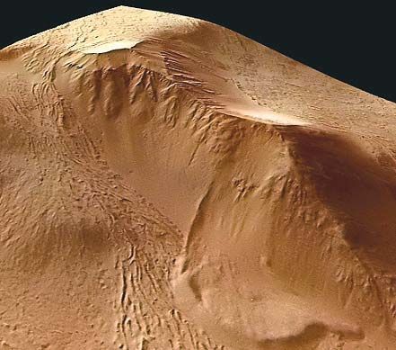
hartmann   16-12-2005       10:40    Pagina 216

           216                        W.K. Hartmann, D. Winterhalter & J. Geiss

           ic age. The crater count system is much less accurate than radiometric dating,
           yet, significantly, certain Mariner 9 and Viking-era crater-count efforts revealed
           that at least some Martian lava plains formed as recently as the last few hundred
           million years6, a conclusion controversial at the time, but later found to be
           consistent with radiometric ages of Martian meteorites10 (see below).

           The Martian Meteorites

           By the early 20th century, the chemistry and mineralogy of a few rare stony mete-
           orites indicated that they did not fit into the classification scheme used for all the
           other meteorites. Three classes of these rare stones were identified: the
           Shergottites, Nakhlites, and Chassignites (named after the place of fall of the
           first example in each class) or, in short, SNC-meteorites. When radiometric dat-
           ing of meteorites began in the 1950s, most meteorites were dated at more than
           4000 My, compatible with an asteroidal origin. A Shergottite, however, gave an
           age of only a few hundred million years. Such young rocks could hardly have
           formed by igneous processes in an asteroid, because asteroids cooled several bil-
           lion years ago. Then in the 1980s, researchers recognized that the SNC rocks

           Figure 4. Comparison of lunar and Martian sam-         Figure 5. Comparison of the geologic
           ple thin sections. Left: A lunar mare basalt lacking   time scales of the three best-studied terres-
           any evidence for volatiles (sample collected by        trial worlds. On Mars, three major epochs
           Apollo 11 astronauts in Mare Tranquilitatis).          (Noachian, Hesperian and Amazonian)
           Right: Martian igneous cumulate ALH 84001,             have been defined by Tanaka6 using com-
           containing carbonates left by evaporation of           parison of impact-crater densities.
           mineral-rich water. (Courtesy Beda Hofmann,            Radiometric ages have been determined
           Naturhistorisches Museum, Burgergemeinde Bern,         for the known classes (S, N, C, ALH) of
           Switzerland)                                           Mars meteorites.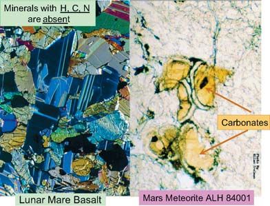
hartmann   16-12-2005   10:40    Pagina 217

                                Chronology and Physical Evolution of Planet Mars            217

           included gas that exactly matched the Martian atmosphere, and that they had
           been blasted off Mars by asteroid impacts.

           Today, the Martian origin of SNC meteorites is undisputed. About thirty of them
           are presently known. One (ALH 84001) is a very ancient igneous cumulate rock
           dating from 4500 My ago – apparently a piece of the original crust of Mars. All
           the others are relatively young metamorphic igneous rocks, dating from 170 My
           to 1300 My ago. Their launch from Mars implies that they resided within near-
           surface (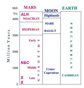
hartmann   16-12-2005     10:40   Pagina 218

           218                    W.K. Hartmann, D. Winterhalter & J. Geiss

                 picked up at large distance from Copernicus. Carefully selected lunar rock
                 samples from large, young lunar craters would be extremely helpful in cali-
                 brating the curve in Figure 3. Sample return from the western regions of
                 Oceanus Procellarum would also be desirable, because some lava flows in
                 these regions have been interpreted as younger than 3000 My. They could
                 help calibrate the diagram.

           2. Determine the absolute ages of the middle and early Amazonian, and of the
              late Hesperian regions on Mars. This would involve sample-return missions
              landed on carefully chosen geologic units of well-determined stratigraphic
              age. Crater counts on those units would then directly calibrate Figure 3.

           3. Identification of the source area for specific Martian meteorites might be
              possible. For example, the four Nakhlites and Chassignites analyzed so far
              have identical radiometric ages of 1300 My. Moreover, all four have ejec-
              tion ages of 11 My10, suggesting that they were ejected from Mars by one and
              the same impact. If the place of origin of these meteorites on the surface of
              Mars could be identified, it would allow calibration of Figure 3. Once the
              curve is calibrated, it will be possible to derive approximate absolute ages,
              within perhaps 20% uncertainty, by counting craters in any extended geolog-
              ic unit on Mars.

           Water on Mars

           Earth’s abundant water is believed to be the key to the origin of life on our plan-
           et. Life formed in the oceans or hot springs, according to currently dominant the-
           ories. If early Mars had rivers and volcanoes, did it once have lakes, seas, and/or
           hot springs, too? By the 1980s, researchers realized Martian water is hidden in
           three places: frozen water in the polar caps, water bound molecule-by-molecule
           in mineral crystals, and massive amounts of water frozen underground, as in
           Earth’s arctic tundra. Early studies12 showed that upper-latitude impact craters
           ejected not dry dust and rocks, but a muddy slurry, indicating penetration into ice-
           rich layers. This effect was used to map the depth to ice as a function of latitude13,
           and also to investigate the possibility that ice flow has modified landforms and
           contributed to ancient “terrain softening” effects. Mars Odyssey, an orbiter that
           arrived in 2001, confirmed the existence of abundant underground ice, within a
           few feet of the surface, at high latitudes14. Thus, a revolutionary change in our
           view of Mars happened by the 1990s, indicating that while Mars has a dry and
           dusty surface, it is actually a wet planet in the sense of having lots of water –
           mostly hidden underground in solid form. This is a step towards explaining the
           ubiquitous river channels discovered on Mars by Mariner 9 in 1972.
hartmann 16-12-2005 10:40 Pagina 219
Chronology and Physical Evolution of Planet Mars 219
Figure 6. Example of a gullied hillside in a
Martian crater at 39°S and 166°W. Gullied hill-
sides are common and generally on young sur-
faces lacking in impact craters, indicating a very
youthful age within the last percent or so of
Martian time. (Courtesy Daniel C. Berman,
Planetary Science Intitute; Mars Global
Surveyor image, NASA/JPL, Malin Space
Science Systems)
There is geomorphic and chemical evi-
dence for the shaping of many Martian
land forms and geochemical weathering
by water. Of particular interest, in terms
of the planet’s water history, are the
indications that many Martian surface
features have been exposed at one time
or another to briny waters15. For exam-
ple, aqueous-alteration products have been documented in the 1300 My-old
Lafayette meteorite, where water exposure was dated as being within the last
700 My16. Thus, this rock was exposed to water not when it formed during
igneous activity, but in an episode at least 600 My later. Furthermore, as seen in
Figure 6, the walls of many mid- and upper-latitude Martian craters reveal very
young, water-caused erosion17, virtually identical in scale and morphology to
gullies on basaltic hillsides of Iceland18.
The problem with Martian surface water flow is how to maintain the liquid state
once it starts to flow. The present-day Martian climate is sub-freezing most of
the time, but temperatures occasionally rise above the freezing point. The
atmosphere has a surface pressure that ranges from only 3 millibars in the high
areas to as much as 10-15 millibars in the lowlands, compared to 1000 millibars
at sea level on Earth. The 6 millibars is a “magic number”: at high Martian ele-
vations with pressure below 6 millibars, liquid water spontaneously bubbles
away. In low-elevation regions with pressures above 6 millibars, it is more sta-
ble, but still evaporates very fast. Thus, water would seem to have a hard time
flowing far under the present conditions, since it tends to freeze and dissipate at
the same time. Paradoxically, however, a Martian river could extend its erosive
lifetime by forming a frozen ice layer on the surface, shielding the water under-
neath from rapid evaporation. More importantly, high salt content helps.
Sufficiently salty brines can stay fluid down to -40°C. Salty water is likely on
Mars, because when water runs across soils or percolates through them, it dis-hartmann 16-12-2005 10:40 Pagina 220
220 W.K. Hartmann, D. Winterhalter & J. Geiss
Figure 7. Polar view of Mars from Mars Global Surveyor. (Courtesy NASA/JPL, MOLA Science
Team and J. W. Head et al.Science 286, 2134, 1999). The colour bar is given in kilometres. Dark
blue shows the lowest present-day altitudes. The black solid lines labeled Contact 1 and Contact
2 have been interpreted to be shorelines20. The case for an ancient ocean shore is stronger for
Contact 2, because it represents an equipotential line in good approximation21, and because the area
at the altitude below is remarkably smooth. Assuming that the present topography is approximate-
ly valid for the time when Contact 2 was formed, the volume contained by this shoreline would
correspond to a global water layer of 100 metres thickness21
solves salts and other minerals. The mineral deposits in Martian meteorites (see
Fig. 4) are thus important in confirming that Martian water was salty.
There is also the likelihood that the earliest Mars had an atmosphere sufficient-
ly dense to maintain liquid water on the surface. Chemical and isotopic analy-
sis of the Martian atmosphere indicates that hundreds of bars of carbon dioxide
were probably emitted by Martian volcanoes. Mars Global Surveyor showed
that Mars’ protective global magnetic dynamo ceased about 4000 My ago (see
below), allowing the solar wind unhindered access to the upper atmosphere.
Rough calculations19 show that the solar wind would erode a 1-bar atmosphere
to the present levels in that time. Thus, current data strongly suggest that Mars
has lost much of an initially much-thicker atmosphere.
An ultimate question about Martian water involves the maximum amount pres-
ent on the surface at any one time. One view, held by some, is that there was
enough to fill northern lowland basins and create an ocean. In the 1980s and
1990s, researchers mapped possible shoreline features and proposed ancient
oceans20; later topographic mapping by the MOLA instrument on Mars Globalhartmann 16-12-2005 10:40 Pagina 221
Chronology and Physical Evolution of Planet Mars 221
Figure 8. Landscape on Meridiani Planum taken by Opportunity Rover in 2004 (Credit:
NASA/JPL/Cornell). Sulphate-rich rocks, hematite spherules in the soils, flat topography, weak
layered rocks, and characteristics of the degraded craters visible from orbit all suggest that this
region may be a large ancient lake bed. The plain is a depressed flat region with ripple relief of a
few centimetres height. The rim of Endurance crater is on the horizon, at a distance of a few hun-
dred metres.
Surveyor proved that some of these shoreline features lie at a uniform elevation,
strengthening the idea that they may have marked the edge of an ancient sea21.
Figure 7, for example, shows a polar view of Mars with dark blue marking the
lowest topography and red and white the highest. The two heavy black “con-
tacts” mark the suggested outline of a transient early north polar sea on Mars,
according to this camp. Pervasive sediments, salts, and underground ice deposits
may be relics of such ancient seas.
Full-fledged oceans remain controversial. Nonetheless, an exciting step came in
2004 when the Spirit and Opportunity rovers landed at two sites where
researchers had deduced that water ponded in ancient times. The most provoca-
tive news was detection of fundamentally new Martian rock types at both sites
– thinly bedded, apparent sediments containing up to 40% sulphates. At the
Opportunity site, a remarkably flat area (see Fig. 8), previously suggested as a
possible ancient lake bed22, where unusual deposits of the iron-oxide mineral
hematite had been seen from orbit, thinly bedded, sulphate-rich sediments were
seen in every crater that punched through the surface. At the Spirit site, on the
floor of Gusev crater, the floor itself was covered with broken igneous rocks, but
the Spirit rover reached old hills protruding above the floor, and these also had
layered, sulphate-rich rocks.hartmann 16-12-2005 10:40 Pagina 222
222 W.K. Hartmann, D. Winterhalter & J. Geiss
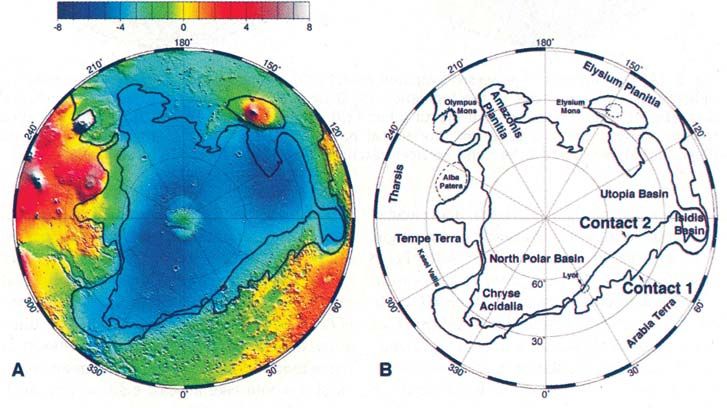
Figure 9. Projection of the MGS spacecraft trajectory and observed magnetic field (B) for MGS
periapsis pass 6, 1997 day 264. The magnetic field is illustrated at 3 s intervals by a scaled vec-
tor projection of B originating from the spacecraft position at such times. Near periapsis, the small-
magnitude solar-wind magnetic field (the closely spaced vectors appear as an undulating thick line
along the trajectory) is replaced by the strong radial vectors from the surface sources25.
Mars’ Early Chronology – The Magnetic Connection
Given that the question of an internal magnetic field is of fundamental impor-
tance to the understanding of Mars’ formation and thermal evolution, and of the
evolution of Mars’ atmosphere, surprisingly few spacecraft sent to Mars were
equipped with instrumentation for such investigations. Of the nine or so orbiters
that achieved Mars orbit, only two returned useful data about the magnetic field
and about the plasma environment near Mars: Phobos 2, and particularly the
more recent Mars Global Surveyor (MGS). The magnetometer data from these
two spacecraft were integrated into a consistent picture of the magnetic environ-
ment of Mars at an ISSI workshop in October 2001, the results of which were
published in the Space Science Series of ISSI23.
The MGS magnetic field investigation provided the first unambiguous detection
of the magnetic field associated with Mars24 (Fig. 9). Measurements made earlyhartmann 16-12-2005 10:40 Pagina 223
Chronology and Physical Evolution of Planet Mars 223
in the mission confirmed that Mars does not currently possess a significant glob-
al magnetic field, yet, at the same time, detected strong, small-scale crustal mag-
netic sources associated with the ancient, heavily cratered terrain. This revealed
that Mars had an internal active dynamo in its past that is now extinct24.
Only a few crustal magnetic sources occur in the young, northern lowland plains
(where the crust is thin). Most of them lie to the south of the dichotomy bound-
ary in ancient, densely cratered southern highlands, and they extend to about
60 deg south of this boundary (see Fig. 10). No strong association between
individual craters and magnetic sources has been found, and no magnetic
sources were detected over Tharsis, Elysium, Valles Marineris, or any of the
other major Martian volcanic edifices. There is an interesting correlation, how-
ever, between the location of the sources and the modification of the ancient
crust by impact basins. The Hellas and Argyre basins, formed during bombard-
ment in the Middle Noachian epoch (~3900 My ago), are devoid of magnetic
sources. The absence of crustal magnetism in these basins and their surroundings
probably implies that the Mars dynamo did not operate when these impact basins
formed and locally disrupted the magnetized crust24. The reasoning is that had
these structures formed in the presence of a large ambient field, they would like-
ly have acquired intense remanent magnetization as the rock cooled below the
Curie temperature – but none is observed. One conclusion would be that the
dynamo had ceased operating just a few hundred million years after the forma-
tion of the planet.
An alternative interpretation would have the large impact basins form prior to
the onset of the dynamo26. This interpretation stipulates that the magnetization of
the southern highlands arose mainly from heating and cooling events that post-
date the era of large impacts and basin formation. This approach is driven main-
ly by the notion that the early onset and cessation of the dynamo would be dif-
ficult to reconcile with a dynamo driven by solidification of an inner core (as is
thought to be the case for Earth)25.
Figure 10. Map of magnetic dis-
turbances on Mars, from Mars
Global Surveyor data. Magnetic
sources in the ancient, southern
cratered highlands indicate mag-
netization of the primordial crust
by a now-defunct global magnetic
field (From Acuña et al. 199924).hartmann 16-12-2005 10:40 Pagina 224
224 W.K. Hartmann, D. Winterhalter & J. Geiss
Figure 11. Left: River channel system of Marte Vallis, showing extensive erosion of young,
sparsely cratered volcanic plain. Low crater densities indicate that this major channel system
formed relatively recently in geologic time. Right: Example of tongue-shaped glacier-like flow
features on the north inner wall of an unnamed Martian crater at 38°S and 247°W. Scarcity of
impact craters on tongues and mantle-like valley fill implies recent formation. The formative
process is not known, but might involve flow of ice-rich materials deposited during climatic
episodes associated with obliquity excursions in the last few tens of Myrs (Mars Global Surveyor
images: NASA, JPL, Malin Space Science Systems, Planetary Science Institute).
There is little doubt that a dynamo existed in the past and ceased to operate in
early Martian history. But apparently there is as yet no unambiguous observa-
tional constraint on the exact timing of the dynamo action. Whatever the cause
is, the dichotomy in magnetization of the Mars crust is perhaps the most signif-
icant clue in the Martian crustal evolution. That the crust of Mars is still intense-
ly magnetized, and the fact that the magnetization displays a coherence over
hundreds of kilometres, persisting for billions of years, requires an iron-rich
crust with a magnetic mineralogy that can acquire and preserve, over aeons, a
large remanent field. Together with inferences on the composition of the Mars
mantle from studies of the SNC meteorites27, this implies an increased oxidationhartmann 16-12-2005 10:40 Pagina 225
Chronology and Physical Evolution of Planet Mars 225
state relative to mantle-derived rock, consistent with assimilation of an aqueous
component at crustal depths25. In recent years, many more MGS results on the
crustal magnetism of Mars have been published and interpreted, providing
increasingly important constraints on the evolution of the planet28.
The discovery of an extinct dynamo on Mars should renew the interest in other
weakly magnetized bodies in the Solar System. A partial magnetization of the
lunar crust was discovered long ago, and an extinct dynamo was considered as
a possible explanation29. Among the satellites of Jupiter, Ganymede is the most
likely to have an internal magnetic field that could result from a dynamo, either
extinct or even active to this day30.
New Views of Mars
The two ISSI Martian volumes emphasize a once-radical view of Mars as a plan-
et with a complex history of volcanic, fluvial, sedimentary, and magnetic activ-
ity, and some level of ongoing, active geological processes in recent geologic
time. This view has been supported and still more radically extended by the
most recent work, including the European Mars Express mission, and many
recent reports refer to papers in the ISSI volumes.
Putting the various lines of evidence together, many researchers agree that most
Martian riverbeds – the “outflow channels” and “valley networks” – formed
long ago, when the Martian air was thicker and climatic conditions were differ-
ent from those of today. Evidence from recent rovers suggests that during that
time fluvial activity was so abundant that temporary lakes accumulated inside
some craters. Connections, as yet poorly understood, may exist among phenom-
ena such as the early largest impacts, convection patterns in the mantle, hemi-
spheric asymmetries and the Tharsis dome, and the cessation of the magnetic
field.
While most Martian river channels date from the first third of Martian time,
according to the crater-count-based chronology, at least one of the Martian river
channel systems, named Marte Vallis, is eroded into unusually young lava
plains. This system is shown in Figure 11 (left), which emphasizes the paucity
of craters. Apparently this river system formed within the last 200 My, possi-
bly within the last 10 My – certainly within the last few percent of Martian his-
tory31. This is consistent with the meteorite evidence, cited earlier, for at least
modest water mobility within the last few hundred million years. Water may be
mobilized sporadically when geothermal activity melts underground ice.hartmann 16-12-2005 10:40 Pagina 226
226 W.K. Hartmann, D. Winterhalter & J. Geiss
Figure 12. New imagery from the European
Mars Express mission utilizes orbital stereo
photography, allowing researchers to make 3D
models and view terrain from different direc-
tions. This view shows part of a scarp on the
giant volcano, Olympus Mons. Climate model-
ling by Francois Forget and French colleagues
suggests massive ice deposition in this area
during obliquity excursions, and some resear-
chers believe that the slump-like feature off the
wall (right) is a young glacial flow covering
striated young lavas (left).
(Courtesy ESA/DLR/FU Berlin, G. Neukum).
Research in 2001-2004 revealed that not only the geology, but also the Martian
climatic environment is dynamically active and changeable32. Mars today has an
axial tilt of 25.2 degrees, close to the 23.5 degree value that causes Earth’s sea-
sons. (This tilt is measured relative to the planet’s orbital plane.) While Earth’s
tilt remains nearly constant due to certain forces exerted by our Moon, Mars’s tilt
currently wanders from 0 degrees to values above 50 degrees, on a geologically
“short” timescale of about 10 My. Costard and co-authors33 and others used this
to study insolation variations on gullied equator-facing versus pole-facing crater
walls and to explain deposition of probable ice-rich mantles that seem to have
been deposited at upper latitudes during recent climatic excursions34.
Calculations of the obliquity during more remote epochs indicated values as
high as 81 degrees, with the most common value being approximately 40
degrees35. This raises the stunning realization that the Mars we see today is not
the Mars that has existed in the past. Today both poles have permanent ice caps
of frozen water and semi-permanent caps of CO2, but in the past, when the polar
axis nodded toward the Sun as much as 40-45 deg, sunlight on the summer pole
was intense enough to “burn off” all the ice. Water-vapour contents increased
by factors as much as 50-100, enhancing deposition of frost and ice at low lati-
tudes. Snow may have been much more common; spring thaws may have led to
more water runoff than anyone believed possible a few years ago. Exemplifying
the unexpected features are glacier-like tongues on the wall of a southern crater
in a region northeast of Hellas18, as shown in Figure 11 (right). The absence of
craters on the slope (as with the Malin-Edgett gully features) suggests a very
young age, consistent with ice deposition during recent obliquity cycles.
Mars Express has added stereo images of possible ice-flow features (Fig. 12),
and this orbiter also confirmed local deposits of hydrated minerals such as gyp-
sum (hydrated calcium sulphate). The new evidence opens the door to the ques-hartmann 16-12-2005 10:40 Pagina 227
Chronology and Physical Evolution of Planet Mars 227
tion of whether life might have started on our next-door planet. This is a perfect
scientific question, because either answer is so profound. If we confirm that
simple bacterial life started on Mars, even if it became extinct later, that will be
the first time humans know that life started on another planet. On the other hand,
if we search Mars and conclude that life never started, in spite of the water, then
maybe we are more alone in the Universe than we thought. Either answer affects
our understanding of our place in the cosmic realm.
References
1. W.K. Hartmann, J. Geophys. Res., 78, 4096, 1973.
2. T.A. Mutch & R.S. Saunders, Space Sci. Rev., 19, 3, 1976.
3. H. Frey, S.E. Sakimoto & J. Roark, Geophys. Res. Lett., 25, 4409, 1998; D.E. Smith & M.T.
Zuber, Geophys. Res. Lett., 25, 4397, 1998; D.E. Smith et al., Science, 279, 1686, 1998; D.E.
Smith et al., Science, 284, 1495, 1999.
4. R. Kallenbach, J. Geiss & W.K. Hartmann (Eds.), “Chronology and Evolution of Mars”,
Space Science Series of ISSI Vol. 12, Kluwer Academic Publ., Dordrecht, 2001, and Space
Sci. Rev., 96, Nos. 1-4, 2001.
5. D. Stöffler & G. Ryder, in Ref. 4, p. 9.
6. K.L. Tanaka, J. Geophys. Res. Supp., 91, E139, 1986.
7. B.A. Ivanov, in Ref. 4, p. 87.
8. W.K. Hartmann & G. Neukum, in Ref. 4, p. 165.
9. W.K. Hartmann et al., “Basaltic Volcanism on the Terrestrial Planets (Basaltic Volcanism
Study Project)”, p. 1050, 1981.
10. L.E. Nyquist et al., in Ref. 4, p. 105.
11. H.J. Melosh, “Impact Cratering: A Geologic Process”, Oxford Univ. Press, New York, 1989.
12. R.O. Kuzmin, “Lunar Planet. Sci. Conf.”, Vol. XI, abstracts, Houston: Lunar and
Planetary Institute, p. 585, 1980; S.W. Squyres, M.H. Carr, Science, 231, 249, 1986.
13. S.W. Squyres, S.M. Clifford, R.O. Kuzmin, J.R. Zimbelman & F.M. Costard, in: H.H. Kieffer,
B.M. Jakosky, C.W. Snyder & M.S. Matthews (Eds.), “Mars”, The University of Arizona
Press, Tucson 1992, p. 523.
14. W.V. Boynton et al., Science, 297, 81, 2002.
15. J.C. Bridges et al., in Ref. 4, p. 365.
16. T.D. Swindle et al., Meteor. Planet. Sci., 35, 107, 2000; C.-Y. Shih, L.E. Nyquist, Y. Reese &
H. Wiesmann, “Lunar Planet. Sci. Conf.”, Vol. XXIX, abstract 1145, Houston: Lunar and
Planetary Institute, 1998.
17. M. Malin & K. Edgett, Science, 288, 2330, 2000.
18. W.K. Hartmann, J. Anguita, M.A. de la Casa, D.C. Berman & E.V. Ryan, Icarus, 149, 37,
2001; W.K. Hartmann, T. Thorsteinsson & F. Sigurdsson, Icarus, 162, 259, 2003.
19. D.A. Brain, “6th Int. Conf. on Mars”, Abstract 3241, Cal. Tech.: Pasadena, 2003.hartmann 16-12-2005 10:40 Pagina 228
228 W.K. Hartmann, D. Winterhalter & J. Geiss
20. T.J. Parker et al., J. Geophys. Res., 98, 11061, 1993; D.E. Smith et al., Science, 284, 1495,
1999J. W. Head et al., in Ref. 4, p. 263; M.H. Masson et al., in Ref. 4, p. 333.
21. J.W. Head et al., Science, 286, 2134, 1999;
22. W.K. Hartmann, O. Popova & I. Nemtchinov, “Lunar Planet. Sci. Conf.”, Vol. XXXIV,
Abstract 1815, Houston: Lunar and Planetary Institute, 2001; W.K. Hartmann, J. Anguita,
M.A. de la Casa, D.C. Berman & E.V. Ryan, Icarus, 149, 37, 2001.
23. D. Winterhalter, M. Acuña & A. Zakharov (Eds.), “Mars Magnetism and its Interaction with
the Solar Wind”, Space Science Series of ISSI, Vol. 18, and Space Science Reviews, 111, Nos.
1-2, 2004.
24. M.H. Acuña et al., Science, 284, 790, 1999.
25. Figure 9 and conclusions reported here are from the article by J.E.P. Connerney,
M.H. Acuña, N.F. Ness, T. Spohn & G. Schubert in Ref. 23, p. 1.
26. G. Schubert, C.T. Russell & W. B. Moore, Nature, 408, 666, 2000.
27. M. Wadhwa, “Lunar Planet. Sci. Conf.”, Vol. XXXI, abstract 1966, Houston: Lunar and
Planetary Institute, 2000; H. McSween et al., 11th Annual V. Goldschmidt Conf., 3012, 2001.
28. J.E.P.Connerney, M.H. Acuña, N.F. Ness, D.L. Mitchell & R.P. Lin, Lunar and Planetary
Science XXXV, Abstract 1114, Houston: Lunar and Planetary Science Institute, 2004; R.J.
Lillis, D.L. Mitchell, R.P. Lin, J.E.P. Connerney & M.H. Acuna, Geophys. Research Lett., 31,
L15702, 2004
29. S.K. Runcorn, Nature, 304, 589, 1983.
30. M.G. Kivelson et al., Nature, 384, 537, 1996; D.J. Southwood & M.G. Kivelson, J. Geophys.
Res., 106, 6123, 2001.
31 D.C. Berman & W.K. Hartmann, Icarus, 159, 1, 2002; D.M. Burr, J.A. Grier, A.S. McEwen
& L.P. Keszthelyi, Icarus, 159, 53, 2002.
32. J. Laskar, B. Levrard & J.F. Mustard, Nature, 419, 375, 2002.
33. F. Costard, F. Forget, N. Mangold & J.P. Peulvast, Science, 295, 110, 2001.
34. J.F. Mustard, C.D. Cooper & M.K. Rifkin, Nature, 412, 411, 2001.
35. J. Laskar, M. Gastineau, F. Joutel, B. Levrard & P. Robutel, “Lunar Planet. Sci. Conf.”, Vol.
XXXV, Abstract 1600, Houston: Lunar and Planetary Institute, 2004.
36. W.K.H. acknowledges support from NASA grant NAG5-12217, and also from the staff of the
Planetary Science Institute in preparing this paper.You can also read