Its4land - Innovative Geospatial Tools for Fit-for-Purpose Land Rights Mapping
←
→
Page content transcription
If your browser does not render page correctly, please read the page content below
Its4land - Innovative Geospatial Tools for Fit-for-Purpose Land Rights
                                  Mapping

     Mila KOEVA, Netherlands; Sophie CROMMELINCK, Netherlands; Claudia
  STÖCKER, Netherlands; Joep CROMPVOETS, Belgium; Serene HO, Belgium;
  César CASIANO, Belgium; Angela SCHWERING, Germany; Malumbo CHIPOFYA,
 Germany; Sahib JAN, Germany; Tarek ZEIN, Germany; Christian TIMM, Germany;
 Kaspar KUNDERT, Rwanda; Placide NKERABIGWI, Rwanda; Berhanu ALEMIE,
                      Ethiopia; Robert WAYUMBA, Kenya

Key words: Horizon2020, Land Recording Tools, Cadastre, East Africa, European
Commission

SUMMARY

Mapping millions of unrecorded land rights in large parts of Sub-Saharan Africa remains a
challenge. The results of many existing ICT-based approaches for recording these rights have
often proven to be inappropriate; therefore, a new generation of tools needs to be developed to
map land rights faster, cheaper, easier, and more responsible. This is the main goal of its4land,
a European Commission Horizon 2020 project that aims to develop innovative tools that
respond to the continuum of land rights, fit-for-purpose approach, and provide cadastral
intelligence. To deliver innovative, scalable, and transferrable ICT solutions, the its4land
project builds on strategic collaborations between the EU and East Africa. The innovation
process incorporates a broad range of stakeholders and emergent geospatial technologies
including smart sketch maps, Unmanned Aerial Vehicles (UAVs), interactive feature
extraction, as well as sharing and publishing land information through geocloud services. The
aim is to combine these innovative approaches with the specific needs, market opportunities
and readiness of end users in the domain of land recording in East Africa. Moreover, the land
recording tools target both top-down and bottom-up approaches and thus support formal land
registration processes, as well as informal community-based land resource documentation. The
project consists of a four-year work plan, €3.9M funding, and eight consortium partners
collaborating with stakeholders from different case study locations in Ethiopia, Kenya, and
Rwanda that cover different land uses such as urban, peri-urban, rural smallholder, and (former)
pastoralists. Major technical tasks include tool development, prototyping, and demonstration
for local, national, regional, and international interest groups. However, equal emphasis is
placed on needs assessment, as well as governance, capacity and business modelling. This paper
will present the unique its4land land administration toolbox in which the exploitable results of
the its4land project are integrated. It will describe each of these exploitable results which cover
different software tools for recording land tenure information based on hand-drawn sketch
maps, UAV-driven workflows for land tenure data acquisition, and semi-automatic and
interactive delineation of visible cadastral boundaries, all integrated in a software platform to
publish and share land information via geocloud services. The toolbox also combines
consultancy services in the fields of needs assessment, and the development of governance and
capacity building models for innovative technologies.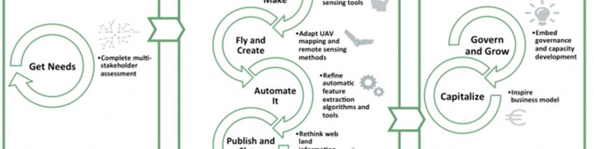
Its4land - Innovative Geospatial Tools for Fit-for-Purpose Land Rights
                                  Mapping

     Mila KOEVA, Netherlands; Sophie CROMMELINCK, Netherlands; Claudia
  STÖCKER, Netherlands; Joep CROMPVOETS, Belgium; Serene HO, Belgium;
  César CASIANO, Belgium; Angela SCHWERING, Germany; Malumbo CHIPOFYA,
 Germany; Sahib JAN, Germany; Tarek ZEIN, Germany; Christian TIMM, Germany;
 Kaspar KUNDERT, Rwanda; Placide NKERABIGWI, Rwanda; Berhanu ALEMIE,
                      Ethiopia; Robert WAYUMBA, Kenya

1. INTRODUCTION

In Sub-Saharan Africa, and also in many developing regions, there are numerous activities for
land tenure recording. However, the results are deviating from the experts’ expectations. With
the challenges of incomplete recordation and escalated land disputes, an innovation for fast,
accurate and cost effective land rights mapping is clearly needed.

A new generation of innovative land tenure tools which are scalable, transparent and applicable
in conventional institutions are emerging. Therefore, the main aim of the of “its4land” project,
a European Commission Horizon 2020 project, is to develop innovative tools that respond to
the continuum of land rights, fit-for-purpose approach, and provide cadastral intelligence.

The innovation process is based on four emergent geospatial technologies: smart sketch maps,
Unmanned Aerial Vehicles (UAVs), automated feature extraction, as well as sharing and
publishing through geocloud services. The aim is to combine these innovative technologies with
the specific needs, market opportunities and readiness of end-users in the domain of land tenure
information recording in East Africa. Moreover, the tools target both top-down and bottom-up
approaches and thus potentially support formal land registration processes, as well as informal
community-based land resource documentation. The project consists of a four-year work plan,
€3.9M funding, and eight consortium partners collaborating with stakeholders from Ethiopia,
Kenya, and Rwanda that cover different land uses such as urban, peri-urban, rural smallholder,
and (former) pastoralists. Major project tasks include contextualization – needs assessment,
software tools development and prototyping, and the development of governance and capacity
building models for innovative technologies, and business modelling. Figure 1 shows the major
tasks of the its4land projects which are being / were achieved.

The tools will be demonstrated to local, national, regional, and international interest groups at
different events, such as the Geospatial Week at the University of Twente – ITC in the
Netherlands, the RCMRD International Conference and 4th AfriGEOSS Symposium in Kenya,
and the AfricaGIS in Rwanda.
Figure 1: Major tasks of the its4land project which are being / were undertaken

This paper reports on the exploitable results of the its4land project. It highlights the potential
opportunity of integrating all technologies and developed workflows into a unique its4land land
administration toolbox. It further describes each of the exploitable results which cover different
software tools for recording land tenure information based on hand-drawn sketch maps, using
UAV-driven workflows for land tenure data acquisition, and applying semi-automatic and
interactive delineation of visible cadastral boundaries, all integrated in a software platform to
publish and share land information via geocloud services. The toolbox also combines
consultancy services in the fields of needs assessment, and governance and capacity building
models for innovative technologies.

2. BACKGROUND

The its4land project is a ‘Research and Innovation Action’ and is formally governed through
the European Commission’s Horizon 2020 Industrial Leadership program focused on
international partnership building in low and middle income countries through the development
of new technologies. More specifically it is the ‘Leadership in enabling and industrial
technologies – Information and Communication Technologies ICT (H2020- EU.2.1.1.)’, under
the call H2020-ICT-2015. The specific topic is ‘International partnership building in low and
middle income countries’ ICT-39- 2015 and part of the global aim of the project is also the
reinforcement of strategic collaboration between the EU and East Africa. It also aims to
demonstrate how multi-sectorial, multi-national, and multidisciplinary design work can take
place.

The project consists of 9 work packages, two of which, the first and the last, are not actively
involved in the tools development process because they cover project management and ethics,
respectively.

The project consortium is multi-sectorial, multi-national, and multidisciplinary. It includes
SMEs and researchers from 3 EU countries and 3 East African countries which are from
Belgium (KUL – KU Leuven), Ethiopia (BDU – Bahir Dar University), Germany (WWU –
University of Muenster; Hansa Luftbild), Kenya (Technical University of Kenya), the
Netherlands (University of Twente), and Rwanda (INES Ruhengeri; ESRI Rwanda). In addition
to technology development, the transdisciplinary work also covers the development of
supportive models for governance, capacity building, and business capitalization. Moreover,
gender sensitive analysis is also incorporated.

In addition to the European Commission project supervision, the project includes a dedicated
advisory board (AB), a valorization panel (VP), and different communications and
dissemination channels. The project also maintains its own ICT infrastructure to support project
management, internal communication, and data management. The setup seeks to cover the
depth and breadth of the land recording tool sector. The project operates in multiple locations
across East Africa, with all case locations having different foci and including a mix of
livelihoods and landscapes such as urban, peri-urban, rural smallholder, and (former) pastoralist
areas.

2.1 Rwanda

In Rwanda there were huge changes with regards to land which aimed at regularizing all existing
lands under private, leasehold, and state tenures To achieve this, a fit-for-purpose approach
was used to rapidly record the whole country with an accuracy of 1-5m. More than 10 million
land parcels were registered between 2009 and 2013. The challenge still remaining is how to
keep the system up-to-date. As discussed also by Ho et al (2017) in Musanze, up-to-date land
information is needed to balance the demand for urbanization and expand tourism. However,
there are some economic and administrative factors that affect its realization due to current
mechanisms and processes which do not actively facilitate data integration with the cadastral
data to support decision-making processes. During field visits, the its4land team observed that
basic topographic information such as buildings, plots and visible infrastructure, etc. is still
missing – data which is important for planning at all levels. Therefore, selecting a suitable
geospatial technology which can be used for maintaining and updating land information in a
fast and affordable way will potentially contribute to this challenge. In this context Unmanned
Aerial Vehicles (UAV) were used to acquire aerial imagery swiftly which was used to obtain
and collect up-to-date land information.

2.2 Kenya

In Kenya, pastoralism constitutes 84% of the country’s total land use. Therefore, one of the
main challenges for the its4land project was to find the most suitable solution for recognizing
pastoralist land rights, most of which have been held under customary tenure arrangements,
which up till 2016, were not constitutionally recognized as a legal tenure type. However, such
land use is temporally and spatially dynamic. This is exacerbated by colonial and post-colonial
land reforms that sought to privatize land rights; however, weak land governance systems have
resulted in poor quality land information. This has led to a lack of transparency over land
dealings, thus resulting in chronic land related conflict in the country. its4land aimed in Kenya
at leveraging the need for geospatial technologies to not only contribute to mapping pastoral
land rights, but more generally to contribute to improving the quality of land information in the
country. Here UAV, sketch mapping and feature extraction technologies were applied and used
to collect geospatial data and information.

2.3 Ethiopia

The its4land project in Ethiopia has focused on two different cases: peri-urban and rural
landscapes. Bahir Dar is one of the fastest growing cities with dominant peri-urban territories
where the growth is in all directions. In Ethiopia the urban land administration and the rural
land administration are separated in different institutions. Moreover, with these complexities in
the landscape to distinguish between clear boundaries is quite challenging. For establishing
cadastre and land administration system in the urban areas different donors, stakeholders and
authorities are joining their forces. After the analysis of the possible available tools, the usage
of high-resolution UAV images, geocloud services, usage of sketch maps and automatic
techniques for boundary delineation are seen as potential solutions to improve existing land
recording processes. In the rural areas high level land degradation and land fragmentation were
observed. For reducing poverty and enhancing land productivity, responsible land consolidation
is seen as a solution. Therefore, in the rural areas in Ethiopia there is a clear opportunity for
providing local stakeholders with information such as up-to-date images and tools for recording
land data to help in the land consolidation process.

3. its4land KEY EXPLOITABLE RESULTS (KER)

Work packages 2 to 7 of the its4land project created different results which can be exploited by
the land administration community in developing countries. These results are bundled in a
toolbox which will provide services and products that can benefit the land administrators and
facilitate their work. Table 1 shows the key exploitable results (KER) of each of the concerned
work packages and their type, being a consultancy service or a software tool:

  KER Type          KER Name                         KER Brief Description
 Consultancy      Needs                Consultancy services for needs assessment
                  Assessment
 Software         Smart SketchmapSmart Sketchmap is a tool to record aspects of people to
                  (SmartSkeMa)   land relationships where the spatial component is
                  Data Collectioncaptured using hand drawn sketch maps and described
                  Tool           in a qualitative way (not surveyed) and then
                                 automatically transformed for further usage in a GIS
 Consultancy      UAV-based Data Consultancy services for UAV-based data acquisition
                  Acquisition    for land tenure recording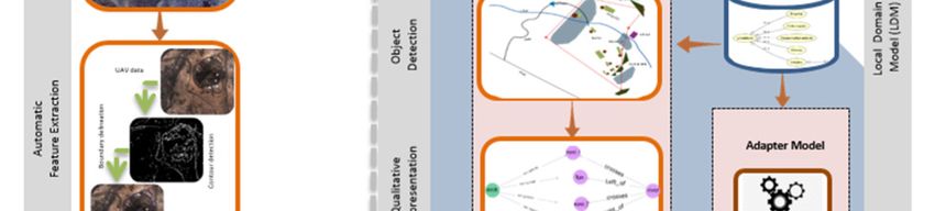
KER Type          KER Name                         KER Brief Description
 Software         Semi-automatic    A tool that facilitates image-based cadastral mapping by
                  Visible           extracting visible boundaries automatically and by
                  Boundaries        supporting the delineation procedure.
                  Delineator
 Software         Publish and Share Platform with integrated tools to publish and share land
                                    information.
 Consultancy      Governance and Consultancy services to apply the governance and
                  Capacity          capacity development models for the use of the its4land
                  Building          geospatial tools

Table 1: Key exploitable results of the its4land project with their defined names and types
All the KERs which are resulting from the its4land project are bundled in the its4land toolbox,
a box which offers services and software tools which can be ordered separately or jointly by
the interested entities or organizations.

3.1    Description of the KERs
Consultancy services for needs assessment
There is currently very limited literature (both grey and academic) published on stakeholder
needs assessment for land administration projects. In fact, some have criticised

The KU Leuven project partner performed the task of capturing the specific needs, market
opportunities, and readiness of end-users in the domain of land tenure information recording.
In 2017, it engaged with 57 organizations and community groups across the three case countries
(more than 100 individuals) – Ethiopia, Kenya and Rwanda – seeking to identify relevant land
issues, document land tenure information needs, readiness requirements for using its4land
technologies and potential market opportunities.

The data collected indicated that cadastral data is still recognized as a critical land information
need. This encapsulates common conventional requirements (e.g. accurate spatial data, tenure
systems and inherent rights, restrictions and responsibilities [RRR]), and a range of
socioeconomic attributes of the right holder. The history of land-based conflict in these
countries directed the need to acquire other ownership evidence (e.g. history of acquisition,
neighbours, etc.) to support unambiguous determination of land tenure RRRs. Poor
expropriation and compensation practices also stimulated the desire among communities for
other property data (e.g. type of crops, fixtures on land, irrigation systems, etc.). Rwanda offered
a point of difference: a centralized government focused on balancing urban-regional growth
linked land information needs to development objectives. Therefore, needs were focused on
improving the quality of non-cadastral data and integrating this with the cadastral fabric for
more insightful decision-making. In addition, since Rwanda’s national land tenure
regularization program has provided the government with a good source of data for decision-
making, stakeholders agreed on the need to maintain the quality of cadastral data and improve
data management especially data accessibility.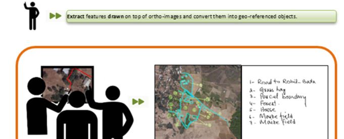
To meet these needs, UAV technology was considered to be of greatest potential to exploit. The
other its4land tools – smart sketch maps, automated feature extraction and geocloud services –
had less clear innovation pathways, attributed to the difficulties that stakeholders often had in
understanding the concepts behind the technologies, and often based their perceptions on the
more familiar aspects of the technologies. Common readiness requirements identified included
strategic requirements (align needs with policies, political will and change leadership);
structural and/or governance requirements (develop appropriate frameworks to direct action at
a national level coordinate and manage new relationships between stakeholders for using the
technologies and their data); organizational requirements (local changes that build
organizational capacity including technical elements).

Thus the experience gained and the expertise built in this its4land project task qualifies the
its4land project partners to offer consultancy services in the area of needs assessment to
organisations (public / private or NGO) which are embarking on establishing a land
administration framework.

SmartSkeMa: sketch based data collection tool with interactive digital output
Smart Sketch Maps (SmartSkeMa) is a set of linked sub-tools which can be applied to two
workflows, one workflow covers the alignment of sketched information to base map data, while
the other workflow concerns the alignment of sketched information to existing ortho-imagery.
The workflows outline and sequence the activities which a data collector needs to follow in
order to best use the sub-tools provided. Figure 2 and Figure 3 show the two workflows.

For example, before using the SmartSkeMa system to extract objects represented by symbols
from any map, the user must first train the system to recognize these symbols. Therefore, there
is a procedure that describes how to train the system to recognize symbols. The set of
SmartSkeMa sub-tools consists of:

   1. a specialized domain model and an associated visual language for sketching;
   2. a system for automated recognition and extraction of objects in sketch maps;
   3. a system which integrates sketched information into existing geo-referenced datasets
      using qualitative representations;
   4. two supporting tools:
       A. one for training the symbol detection algorithm for objects that a group of users
            would want the system to recognise; and
       B. another for visualizing and interacting with the sketch map information in the
            context of the existing data.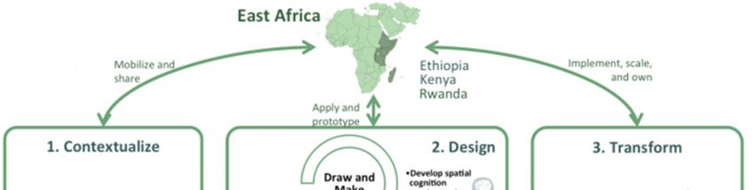
Figure 2: Workflow for aligning sketched information to base map data
SmartSkeMa sub-tools target NGOs, private organizations, research institutions, and government
agencies using sketching as part of their work in the land/natural resources sectors. The its4land project
partner at the University of Muenster (WWU), implemented the sketch based geospatial data
recording tool, SmartSkeMa, to capture land tenure data from a local perspective. The
implementation of the tool consisted of (i) developing a domain model of concepts used in the
description of land resources and tenures within localized contexts (e.g. at community level or
within cultural groups); (ii) developing spatial models for representing sketch maps as records
of land tenure information; and (iii) developing methods for recognition of land tenure sketch
maps (Murcia et al. 2018) and for embedding the sketch maps within existing spatial data sets.
The implementation was tested on data collected in the field in Ethiopia and Kenya.

To the end user all these sub-tools will be experienced as a single integrated software. SmartSkeMa is,
therefore, marketed either as a software tool for data collection or a tool for rapid drafting using sketch
maps. Usage of the tool may require initial setup and continuous support which are offered as a service.
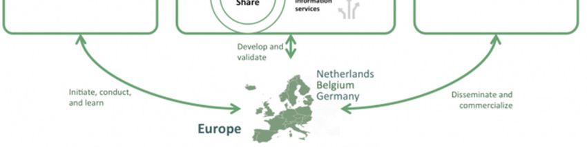
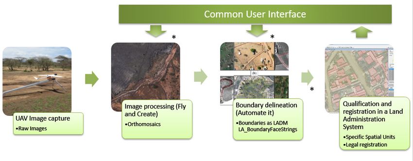
Figure 3: Workflow for aligning sketched information to ortho-imagery
Consultancy services for UAV-based data acquisition for land administration
The consultancy services include guidelines and a customizable workflow for UAV-based data
acquisition in the context of land administration. Figure 4 shows the generic workflow of UAV-
based data acquisition. The workflow is designed following a logical approach which facilitates
all steps needed to provide up-to-date and high-resolution ortho-imagery as a geospatial source
for land information. The first phase includes the study of policy and legal requirements
regarding the successful implementation of UAV data acquisition workflows within the context
of a concerned country. Outcomes of the statutory prerequisites, technical features as well as
characteristics of the application and country context provide the necessary framework to
design efficient operational workflows which meet the needs of respective users and/or
applications. Workflows encompass the entire operational UAV procedure including flight
planning and preparation, data acquisition, data processing and quality assessment. The
consultancy services will target surveyors, para-surveyors and experts in the land
administration sector. However, government organisations, NGOs, local communities as well
as grassroots organisations can also use the guidelines and request consultancy services if they
want to capture high-resolution aerial imagery with UAVs for purposes other than land
administration.
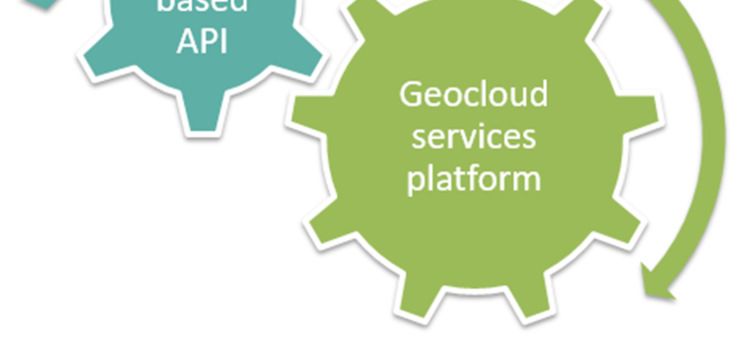
Figure 4: Generic workflow for UAV-based data acquisition
The team from the University of Twente (ITC) designed, tested and validated the UAV driven
land administration workflow in different contexts by using various UAV equipment as well as
different ground truthing strategies. Key aspects covered regulatory frameworks in Kenya and
Rwanda, the minimization of ground measurements and the implementation of the UAV-driven
workflow to collect land data in Rwanda and Kenya. The operational workflow was tested and
validated through flight missions across Africa and Europe.

Semi-automatic delineator of visible cadastral boundaries from optical high resolution sensors
The software tool supports the delineation of boundaries by automatically retrieving
information from aerial / satellite imagery and by coupling this information with the subsequent
delineation procedure. The tool focuses on improving current indirect surveying approaches in
terms of cost, time and accuracy and consists of three parts: (i) image segmentation, (ii)
boundary classification and (iii) interactive delineation. Figure 5 shows the workflow of the
semi-automatic visible boundary delineator.

This innovation was led by the University of Twente (ITC) and aimed at designing and
implementing the software tool for visible boundary delineation in the context of cadastral
mapping. This was achieved by supporting the delineation of visible cadastral boundaries
through automatically extracted features from UAV data collected for the its4land project and
from ortho-imagery which was provided by the Ethiopian project partner, Bahir Dar University.
Figure 5: Workflow of the semi-automatic visible boundary delineator
Land information platform for publishing and sharing
Publish and Share is a geocloud platform for hosting and integrating tools and data which
facilitates land tenure recording services and applications. With Publish and Share, UAV image
processing, qualitative data processing and boundary delineation can be integrated into existing
or new land administration workflows. Thus, it provides the framework of common APIs and
services used by all its4land tools. Following the toolbox approach the user can select those
its4land tools fitting best to his tasks or can integrate his/her own tools.

Publish and Share is based on three main concepts:
   • LADM (ISO 19512: Land Administration Domain Model)
   • Web based API
   • Geocloud services platform
How do these three concepts work together?
  • LADM provides the conceptual framework of terms. A developer who is familiar with
      LADM will recognize known concepts like SpatialUnits, AdminSources, etc. These
      concepts are available in the Publish and Share API. Their localized meaning depends
      on the country-specific implementation.
  • The web based API is a state of the art REST-API that is independent of programming
      languages and operating systems.
  • The geocloud service platform offers a flexible and scalable structure with high
      availability. The common data repository and re-use of functionality help to reduce the
      amount of work in standard administration tasks.

Figure 6 shows the core concepts of the Publish and Share platform.

The main aspect of Publish and Share is the dissemination and sharing of data created by
its4land tools to external user or systems. This is achieved by service interfaces based on
standards from OGC and W3C. The modelling of the interfaces follows the concepts introduced
by LADM. External systems such as land administration systems (LAS) or planning systems
can use this to integrate data into their own processes, which are based on specific national
rules.
Figure 6: Core concepts of the Publish and Share platform
For seamless integration with existing systems, Publish and Share is implemented on standards
such as REST, LADM and OGC OWS. Publish and Share is composed of four technical
components:
1. a set of public REST-APIs that allows tools and applications to interact with the Publish
and Share platform;
2. a runtime tool environment for Smart Sketchmap, UAV image processing, boundary
delineation and other tools;
3. a data repository for alphanumeric, geodata, binary and image data; and
4. OGC services for data dissemination (for publishing and sharing data).
Figure 7 shows the technical components of the Publish and Share software platform.
The platform is not primarily intended as an out of the box software for end-users. As a geocloud
platform, Publish and Share provides technical services to support land administration projects
in implementing their own tools, applications and workflows.Figure 7: Technical components of the Publish and Share software platform The platform offers different development models to achieve such an implementation. These are: Integration: Existing land administration systems can integrate the Publish and Share functionalities into their own workflows. An example for this development model is the use of the boundary delineation methods from work package 5 in a parcel based cadastre application to improve parcel delineation workflows. Figure 8 shows the current software tools which are integrated in the Publish and Share platform. It also shows that the platform can be integrated in an existing land administration system workflow. Application: An application targets an end-user. Typically an application is developed as a single page web application or mobile application and relies on the Application Programming Interface (API) provided by the platform. Other types of applications are possible; e.g. a QGIS- plugin that interacts with Publish and Share. An application typically implements a domain or user specific workflow. Tools: A tool implements a self-contained functionality. Typically these are CPU and storage intensive tasks with little or no interactive usage. Tools make use of the API and data models specified by the platform for input/output and to organize information, however, they operate in an isolated / independent fashion. The algorithms and methods developed in the work packages 3, 4 and 5 are implemented as tools in Publish and Share. Platform extension: A platform extension implements functionalities at the level of the platform API. A typical platform extension could be a new API method that provides data from Publish and Share in a specific way for a land administration system. All components developed for the Publish and Share platform are open source software. The components can be hosted in a cloud environment such as Amazon Web Services, Microsoft Azure or any private cloud environment. The reference implementation of Publish and Share was tested and validated using Amazon Web Services.
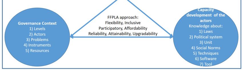
Figure 8: Integrated software tools in the Publish and Share platform and integrating the
platform in land administration system workflows.
The its4land project partner Hansa Luftbild developed the Publish and Share platform for
hosting and integrating the results, the methods and the software tools developed by the other
its4land project partners.

Consultancy Services for developing governance and capacity models for geospatial tools
The governance model will support the use of the innovative geospatial tools by aligning end-
users conditions, technological opportunities, and capacity building requirements. A good
understanding of the limitations and the successes of current governance strategies will help to
deliver insights in the contemporary governance performances in the context of geospatial
innovation implementation in East Africa. The three project countries provide insights into
common land tenure challenges across Sub-Saharan Africa. These insights might offer
transferability of lessons learned to other countries in Sub-Saharan Africa and beyond. The
consultancy services are offered to organisations (public / private or NGO) which are
embarking on the application of the its4land software tools / platforms with tailored governance
and capacity building models which best fits their requirements. These models are aligned with
the seven Fit-for Purpose Land Administration (FFPLA) elements which are flexibility,
inclusivity, participatory, affordability, reliability, attainability and upgradability. The
governance of the its4land tools is defined as “the process of interactively steering the land
tenure society to sustain the use of the its4land tools”. The capacity development for the
its4land tools is defined as “The development of knowledge, skills and attitudes in individuals
and networks of people that are relevant for the uptake and sustained use of the its4land tools”.
Figure 9 shows the initial governance and capacity models developed for the its4land tools.

The its4land project partner, KU Leuven, undertook the work dealing with the development of
the governance model (including a model for capacity development) to support the use of
innovative tools.
Figure 9: Initial governance and capacity model which has been developed for the its4land
geospatial tools
In addition, if organisations prefer to adapt the developed governance and capacity models for
different geospatial tools other than the its4land tools then consultancy services for the
adaptation can also be provided.

3.2 Capitalizing on its4land KERs
The development of a sustainable business model for commercialization of the integrated suite
of land tenure recording tools, within the end-user markets, is also a major task of the tis4land
project. Using the different software tools and the software platform for geocloud services
resulting from the is4land project and in parallel with the development of sustainable
governance and capacity building models, actor preferences (local communities, government,
investors, and small and medium-sized enterprises) have been combined to launch the its4land
land administration toolbox. This will be in accordance with the lean canvas business model
and the business plan which has been developed to commercialise the toolbox.

Hansa Luftbild, the project partner for capitalization, in cooperation with the project partner
Esri Rwanda, developed the business model and the business plan and plans to launch the
its4land toolbox at different events.

4. SUMMARY
Eight its4land project partners collaborated together, supported by an advisory board and with
the feedback from a valorization panel, created new innovative tools which support faster,
cheaper, easier, and more responsible land rights mapping which are aligned to the Fit-for-
Purpose Land Administration approach. This collaboration resulted in the integrated its4land
land administration toolbox which has been tested and validated in case study locations in the
East African project partner countries. The toolbox contains different software tools and
consulting services which can be commercialised and offered to the land administration
community. The tools in the box are offered separately or as different bundles, depending on
user requirements and country contexts. Using the toolbox will ensure its sustainability and
consequently support land administrators during the land tenure recording process.

ACKNOWLEDGEMENTS
The research described in this paper was funded by the research project “its4land”, which is
part of the Horizon 2020 program of the European Union, project number 687828.

REFERENCES
Bennett, R., Kitchingman, A., & Leach, J. 2010. “On the nature and utility of natural boundaries
       for land and marine administration”. Land use policy, 27(3), pp.772-779.

Bennett, R. M., & Alemie, B. K. 2016. “Fit-for-purpose land administration: lessons from urban
and
       rural Ethiopia”. Survey Review, 48(346), pp.11-20.

Biraro, M., Bennett, R. M., & Lemmen, C. 2015a. “Accelerated Land Administration Updates”.
        In: Advances in Responsible Land Administration, pp. 145-162.

Biraro, M., Khan, S., Konguka, G., Ngabo, V., Kanyiginya, V., Tumusherure, W., Potel, J.
        2015b. “Final Report of Study on the access to the land tenure administration system in
        Rwanda and the outcomes of the system on ordinary citizens”. LAND Project, USAID,
        Kigali, Rwanda.

Chipofya, M. C., Jan, S., Schultz, C. and Schwering, A. (2017). TowardsSmart Sketch Maps
      for Community-drivenLand Tenure Recording Activities. AGILE 2017, Wageningen,
      the Netherlands.

Chipofya, M., Schultz C., & Schwering, A. (2016) A metaheuristic approach for efficient and
      effective sketch-to-metric map alignment. International Journal of Geographical
      Information Science, 30 (2), 1–26.

Crommelinck, S., Bennett, R., Gerke, M., Nex, F., Yang, M., Vosselman, G. 2016. “Review of
     Automatic Feature Extraction from High-Resolution Optical Sensor Data for UAV-
     Based Cadastral Mapping”. Remote Sensing, 8(8), pp.1-28.

Crommelinck, S., Bennett, R., Gerke, M., Koeva M.,Yang, M. Y., & Vosselman, G. 2017a.
     “SLIC Superpixels for Object Delineation from UAV Data”. UAV-g conference, Bonn,
     Germany, pp.1-8.

Crommelinck, S., Bennett, R., Gerke, M., Yang, M. Y., & Vosselman, G., 2017b. “Contour
     Detection for UAV-Based Cadastral Mapping”. Remote Sensing, 9(2), pp.1-13.
Crommelinck, S.; Höfle, B.; Koeva, M.N.; Yang, M.Y.; Vosselman, G. In Interactive boundary
delineation from UAV data, ISPRS TC II Symposium, Riva del Garda, Italy, 04-07 June,
2018; IV-2, pp 81-88.
Dalal N, and Triggs B. 2005. “Histograms of Oriented Gradients for Human Detection.” In
CVPR 2005, IEEE Computer Society Conference On Computer Vision and Pattern
Recognition, 1:886–893. IEEE.
de Vries, W. T., Bennett, R. M., & Zevenbergen, J. 2015. “Toward Responsible Land
Administration”. In Advances in Responsible Land Administration, pp. 3-14.
Ho, S., Biraro, M., Muvunyi, G., Wayumba, R. 2017. “Field Data Results, Version 1.”, its4land,
KULeuven, Belgium
ICAO, 2011. Unmanned Aircraft Systems (UAS). Cir 328 AN/190.
Karamesouti, M., Schultz, C., Chipofya, M., Jan, S., Murcia Galeano, C. E., Schwering, A., and
Timm, C.: THE MAASAI OF SOUTHERN KENYA DOMAIN MODEL OF LAND
USE, ISPRS Ann. Photogramm. Remote Sens. Spatial Inf. Sci., IV-4, 105-112,
https://doi.org/10.5194/isprs-annals-IV-4-105-2018, 2018.
Koeva, M., Muneza, M., Gevaert, C., Gerke, M., & Nex, F. 2016. "Using UAVs for map
creation and updating. A case study in Rwanda", Survey Review, 1-14.
Lengoiboni, M., Arnold K. Bregt, and Paul van der Molen. 2010. "Pastoralism within land
administration in Kenya—The missing link." Land Use Policy, 27.2 pp.579-588.
Murcia Galeano, C., Chipofya, M., Jan, S., Schultz, C., Karamesouti, M., and Schwering, A.
2018. “Practical Sketch Recognition for Land Tenure Mapping”. 26th GIScience
Research UK Conference. University of Leicester, April 2018.
Stöcker, E.C., Bennett, R.M., Nex, F.C., Gerke, M. and Zevenbergen, J.A. 2017. “Review of
the Current State of UAV Regulations”. In: Remote Sensing: open access, 9 (2017)
5article no. 459, p.26
Stöcker, C., Nex, F. C., Koeva, M. N., & Gerke, M. (2017). Quality assessment of combined
IMU/GNSS data for direct georeferencing in the context of UAV-based mapping. The
International Archives of Photogrammetry, Remote Sensing and Spatial Information
Sciences 42 (2017): 355.
UN-HABITAT. 2012. “Handling Land–Innovative Tools for Land Governance and Secure
Tenure”. GLTN. Nairobi.Viola P, and Jones M. 2001. “Rapid Object Detection Using a Boosted Cascade of Simple
Features.” In CVPR 2001, Proceedings of the 2001 IEEE Computer Society Conference
On Computer Vision and Pattern Recognition, 1: I–I. IEEE.
Zevenbergen, J., Augustinus, C., Antonio, D., & Bennett, R.. 2013. “Pro-poor land
administration: Principles for recording the land rights of the underrepresented”. Land
use policy, 31, pp.595604.
Zevenbergen, J., and Bennett, R. 2015. “The visible boundary: More than just a line between
coordinates”. In GeoTechRwanda, Kigali, Rwanda, pp 1-4.
BIOGRAPHICAL NOTES
Tarek Zein an International Director / Project Manager for Hansa Luftbild, Germany, is a
graduate of Victoria University in Wellington, New Zealand. He has extensive international
experience in the GIS and mapping fields and has managed projects in Germany, New Zealand,
Lebanon, Saudi Arabia, the Sultanate of Oman, Djibouti and Ethiopia. In 2013 Mr Zein
completed the management of a major cadastre project for Addis Ababa City Government and
in 2018 completed the project management of the National Rural Land Administration
Information System of Ethiopia. He is Hansa Luftbild’s project manager in the its4land project,
a multidisciplinary European Commission Horizon 2020 project.
CONTACTS
Mr Tarek Zein
International Director
Hansa Luftbild AG, Nevinghoff 20, 48147 Muenster, GERMANY
Tel. +49 (0)251 2330132
Email: zein@hansaluftbild.de
Web site: www.its4land.com,You can also read