Landscape Design Rationale - Auburn House SHD - April 2022 Issue 3
←
→
Page content transcription
If your browser does not render page correctly, please read the page content below
Landscape Design Rationale
            Auburn House SHD

                       April 2022
                          Issue 3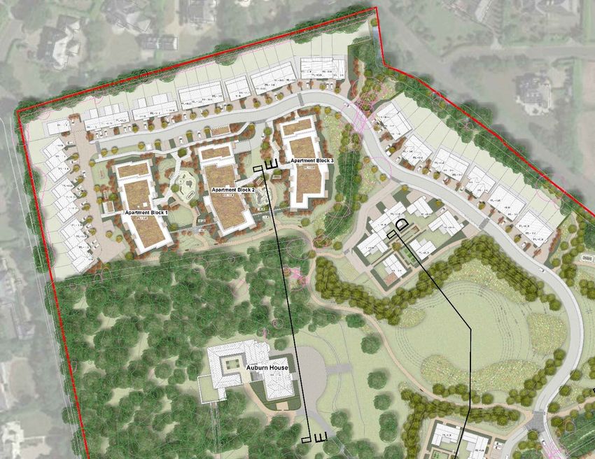
Contents
1. Introduction ......................................................................................................................................................... 1
2.     Existing Landscape & Surrounding Context....................................................................................................... 2
3.     Planning Policy Context ...................................................................................................................................... 5
     3.1.      Protected Views .......................................................................................................................................... 6

     3.2.      Protected Structures, Recorded Monuments & NIAH: .............................................................................. 6

     3.3.      Statutory Designations................................................................................................................................ 6

     3.4.      Landscape Character ................................................................................................................................. 7

4.     Design Rationale ................................................................................................................................................. 8
     4.1.      Description of Proposed Development: ..................................................................................................... 8

     4.2.      Design Approach ........................................................................................................................................ 9

       4.2.1.          Existing Woodland, Trees and Hedgerows: .................................................................................... 11

       4.2.2.          Road Hierarchy and Pedestrian & Cycling Approach: .................................................................... 12

       4.2.3.          Communal apartment spaces ......................................................................................................... 12

       4.2.4.          Play and recreation opportunities: ................................................................................................... 12

       4.2.5.          Lighting: ............................................................................................................................................ 14

       4.2.6.          SuDS: ................................................................................................................................................ 14

       4.2.7.          Biodiversity Benefits: ........................................................................................................................ 14

     4.3.      Character Areas: ....................................................................................................................................... 15

       4.3.1.          Character Area 1 - The Avenue: ....................................................................................................... 16

       4.3.2.          Character Area 2: The Frontfield ...................................................................................................... 21

       4.3.3.          Character Area 3 - The Backfield: .................................................................................................... 23

       4.3.4.          Character Area 4 – Auburn House & The Woodland:...................................................................... 25

       4.3.5.          Character Area 5 - Streamstown ...................................................................................................... 26

5.     Surface Treatments & Site Furniture: ................................................................................................................ 29
6.     Proposed Planting: ........................................................................................................................................... 33
     6.1.      Outline Planting Schedule ........................................................................................................................ 35

7.     Outline of Operations ........................................................................................................................................ 38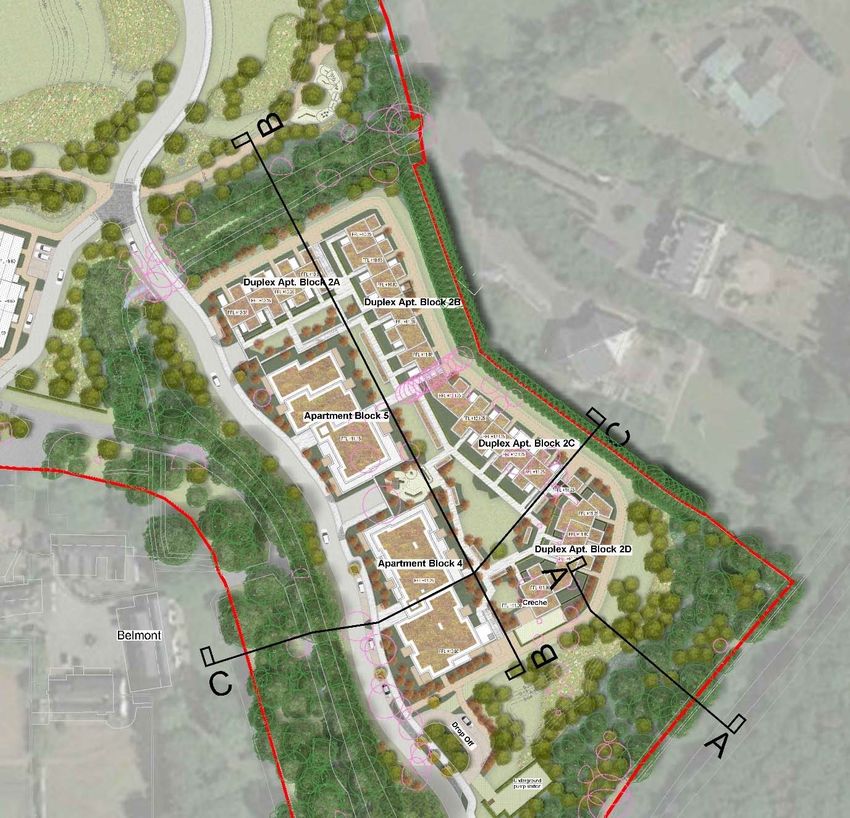
1. Introduction
The Landscape Development Report has been prepared by The Big Space Landscape Architects on
behalf of Kinwest Ltd. (the applicant) to describe the landscape proposals for the development of lands
at Auburn, Malahide.
The report is intended to be read in conjunction with:
   •   Landscape drawings:
           –   1489_300 - Landscape Plan
           –   1489_301 - Detail Sheet 1
           –   1489_302 - Detail Sheet 2
           –   1489_303 - Play and Recreation Proposals
           –   1489-304 – Proposed Boundary Treatments
           –   1489_305 - Proposed Tree Planting, Lighting & Services
           –   1489_306 - Planting Details
           –   1489_307 - Planting & Phasing
           –   1489_308 - Existing trees & Proposed Planting
   •   Historical Landscape Report prepared by The Big Space
   •   The Arboricultural Survey and Reports prepared by The Tree File
   •   Conservation Report prepared by Sheehan & Barry

                                                                                                      1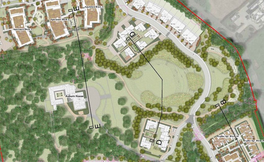
2. Existing Landscape & Surrounding Context
The subject site is located approximately 2 km south-west of Malahide Village, within the townland known
as Streamstown and covers an area of approximately 13.28 hectares.
The lands are located 12km north of Dublin City Centre and 6km north of Dublin Airport.
The M1/ R125 motorway interchange is located approximately 3km to the west of the subject site and
Malahide train station is located 2km from the site and is served by the Northern Commuter and DART
systems. The subject site is accessed off Malahide Road and a tree lined driveway provides access to
Auburn House.

Figure 2.1: Location of subject site

While there seems to have been some type of settlement on this site since the 1700’s, as indicated on
Rocque’s 1760 survey of Co. Dublin, the current configuration of Auburn House was constructed in
c.1779. The driveway, Auburn House and the woodland to the north, west and south of the house are
represented on Taylor’s 1816 map of Dublin. On the 1843 map, Auburn House and its stable yard are
shown in more detail, along with the walled garden and orchards, the large open field to the east of the
house, a well-established woodland to the rear of the dwelling with pathways and tree lined field
boundaries.

                                                                                                      2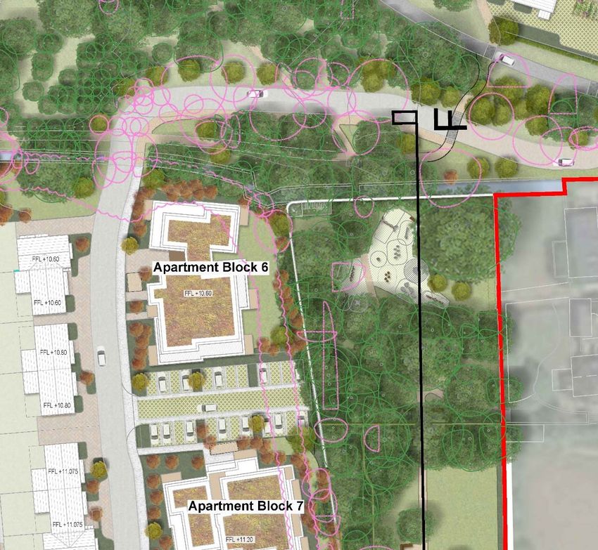
Figure 2.2: Historical Maps - Clockwise from top left: Rocque’s 1760 survey; Taylor’s map - Environs of Dublin
  (1816); Extract from 1829-42 Survey of Dublin; Six-inch OS map (1935-38)
The ground level rises from +9m OD along the eastern and south-eastern boundaries of the site, up to
+10.45m OD at the north-west corner of the subject site and to +14.00m OD at western boundary at
Carey’s Lane. In the field to the north of the house there is a hillock that reaches +12.28m OD and
another in the wooded area to the west of the house that reaches +14.49m OD.
A mature tree belt that runs along Malahide Road, forms the south eastern boundary of the subject site
and there are established wooded areas located to the west, south-west and north-west of the house.
To the east of the house is a large open field that provides views to the boundary tree belts and to the
wooded areas within Malahide Demesne beyond. A tree lined stream divides the main part of the subject
site from Little Auburn to the south. Mature trees and hedgerows with ditches forms the boundaries with
the adjoining lands and separates the northern part of the site, from the field to the front of the house.
The existing woodlands, trees and hedgerows that surround the Auburn House estate, in particular the
wooded area to the east of Auburn House which is evident on Taylor’s 1816 map of Dublin, the tree lined
driveway, walled gardens and the mature tree belt along Malahide Road, greatly contributes to the
historical character and landscape setting of the subject site.

                                                                                                                   3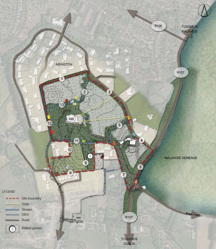
The Abington residential development is located to west, north and north east of the subject site. To the
east of the subject site are large detached dwellings which are accessed off Malahide Road and the
Clairville Lodge residential development, accessed off Carey’s Lane, is located to the south of the
subject lands.

           Figure 2.3: Subject site – Boundary analysis (refer to Historical Landscape Report for further detail)

           (1)      Hedgerow with mature trees and railing between Abington and Auburn
           (2)      Tree lines ditch with fence
           (3)      Tree row between fence line and railing, between Abington and Auburn
           (4)      Belt of evergreen trees
           (5)      Tree lined stream, diving the field (historical field boundary)
           (6)      Mature trees along Malahide Road
           (7)      Tree lined drive up to Auburn House
           (8)      Walled gardens – folly, tree and shrub planting
           (9)      Wall between Clairville Lodge and Auburn
           (10)     Electric fence with low planting
           (11)     Mature trees, stone wall and ditch
           (12)     Tree and hedge planting along gravel track with ditch and fence
           (13)     Ditch with mature tree planting

                                                                                                                    4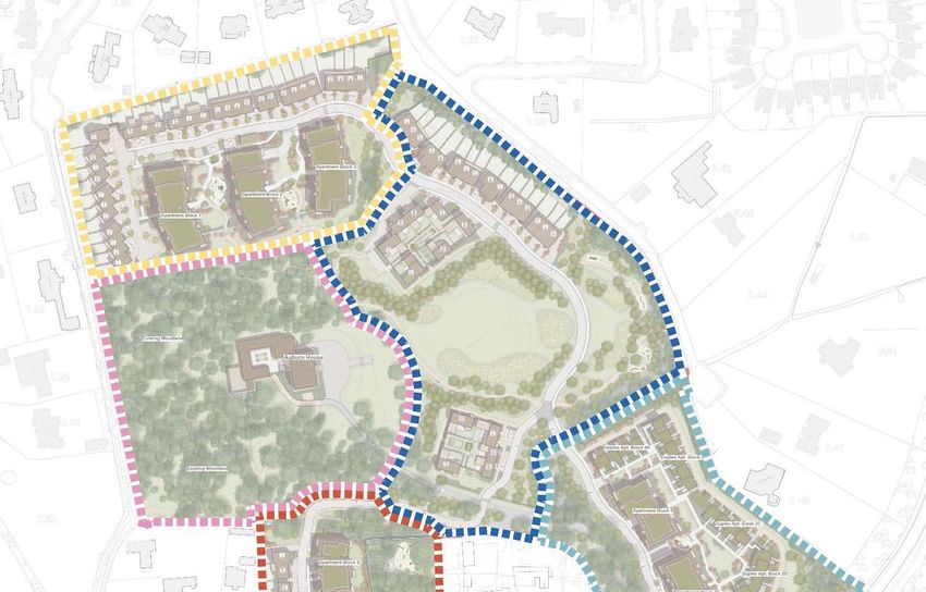
3. Planning Policy Context
The two main texts that were referred to in the compilation of this report were:
    •   Fingal Development Plan (FDP) 2017-2023
    •   Streamstown Local Area Plan 2009

Within the Fingal Development Plan (FDP) 2017-2023 the subject site is located within lands zoned as
“RA” Residential Area, which is defined as:
“Zoning Objective “RA” Residential Area: Provide for new residential communities subject to the provision
of the necessary social and physical infrastructure.”
The FDP 2017-2023 also states that the subject site is located within lands referred to as “Masterplan
Area 9A” which corresponds with the FDP:
“Objective Malahide 11: Prepare and/or implement the following Masterplans during the lifetime of this
Plan: Streamstown Masterplan (see Map Sheet 9, MP 9.A)”.
The FDP further outlines the main points that need to be addressed within this masterplan:
•   “Facilitate low density residential development reflective of the character of the area.
•   Protect and preserve trees, woodlands and hedgerows within the Masterplan area.
•   Preserve the tree lined approach to Malahide along the Dublin Road.
•   Facilitate high quality sustainable development that protects and enhances the sensitive historic and
    natural setting of Auburn House and integrates new development with the conservation and
    preservation of the Protected Structure, its curtilage and protected trees.
•   Retain visual corridors to/from Auburn House through the establishment of a visual buffer to the east
    of Auburn House.
•   The area for development north of Auburn House is considered a sensitive development zone,
    whereby a maximum ridge height of 6m should be applied.
•   Provide for a pedestrian / cycle route along the Auburn House Avenue to Malahide Road.
•   Ensure pedestrian connectivity between Auburn House Avenue and Abington/Gaybrook/Castleheath.
•   The lands will be the subject of a detailed flood risk assessment.”

The following Local Objectives make reference to the mature trees along the eastern boundary of the
subject site with the Malahide Road:
“Local Objective 55: Preserve the tree lined approach to Malahide.
Local Objective 57: New or widened entrances onto the Dublin Road between Streamstown Lane and the
Swords Junction will be restricted, to ensure the protection of the mature tree-lined approach along the
Dublin Road to Malahide.”

                                                                                                        5
3.1.    Protected Views
The FDP 2017-2023 does not refer to any protected views to or from the subject site, however the
Streamstown LAP 2009 does identify the vista from Auburn House looking east towards Malahide
Demesne (refer to Figure 3).

Figure 3.1: Extract for Streamstown LAP (2009) indicating the vista/ visual corridor from Auburn House

In relation to views the Streamstown LAP 2009 also states that:
“There are no notable views from the site given the existing planting, the low lying nature of the land and
existing properties, both within and adjacent to the site. As a result, the area is considered to have an
enclosed character.” (Source: Streamstown LAP 2009)

3.2.    Protected Structures, Recorded Monuments & NIAH:
Protected Structure (RPS): Structures that are considered to be of special architectural, historic,
archaeological, artistic, cultural, scientific, social or technical interest.
Auburn House (including the out-offices and the pigeon loft) is listed as a protected structure listed as
RPS No. 448 – ‘Late 18th or early 19th century house, outbuildings and walled garden’.

3.3.    Statutory Designations
There are no Special Areas of Conservation (SAC), Special Protection Areas (SPA) and Natural Heritage
Areas (NHA) within the subject site.

                                                                                                         6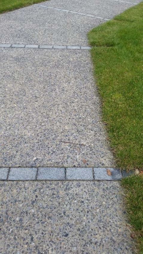
3.4.    Landscape Character
The landscape character of the area within and around the subject lands is identified as ‘Low Lying
Character Type’ within the FDP 2107-2023. This type is “characterised by a mix of pasture and arable
farming on low lying land with few protected views or prospects. The Low Lying Character Type has an
open character combined with large field patterns, few tree belts and low roadside hedges. This low lying
area is dominated by agriculture and a number of settlements. The area is categorised as having a modest
value. It contains pockets of important value areas requiring particular attention such as important
archaeological monuments and demesnes.”
This character type is identified as a ‘low sensitivity’ meaning that “these landscapes can absorb a certain
amount of development once the scale and forms are kept simple and surrounded by adequate screen
boundaries and appropriate landscaping to reduce impact on the rural character of the surrounding roads.
The protection of views and riparian corridors from inappropriate development is of paramount importance
in these areas.” (Source: FDP 2107-2023)
In relation to landscape character the Streamstown LAP 2009 notes that:
“Streamstown is characterised by low-lying, medium-sized fields in agricultural use with low-density
detached dwellings. Field boundaries comprise largely self-seeded hedgerows. The local road network
is rural in character, with Carey’s Lane and Streamstown Lane being bounded by a grass verge, low stone
walls and hedgerows.
The site has a semi-rural character, being bounded to the west by Green Belt zoned lands and to the east
by a significant area of Open Space in the form of Malahide Castle demesne.” (Source: Streamstown LAP
2009)

   Figure 3.2: Landscape Character Types (extracted from FDP 2107-2023 with subject site highlighted)

                                                                                                           7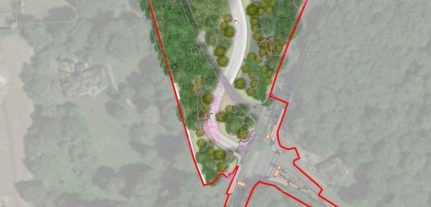
4. Design Rationale
4.1.    Description of Proposed Development:
“The proposed development will consist of the preservation and protection of the existing Protected
Structure of Auburn House and its stables as 1 no. residential dwelling; the conversion of the existing
stables of Auburn House to provide for storage space for the main Auburn House and the construction of
368 no. new residential dwelling units (comprising 87 no. houses, 239 no. apartments & 42 no. duplex
units) for an overall total of 369 no. residential units, including Auburn House. The development shall
consist of 135 no. 1-bedroom apartments and duplex apartments, 138 no. 2-bedroom apartments and
duplex apartments, 8 no. 3-bedroom apartments and duplex apartments, 47 no. 3-bedroom houses, 34
no. 4-bedroom houses, 6 no. 5-bedroom houses and the existing 11-bedroom Auburn House along with
1 no. childcare facility and 1 no. ancillary resident facility. The proposed development shall also provide
landscaped public open space, car parking and all associated ancillary site development infrastructure
including foul and surface water drainage, internal roads, cycle paths and footpaths, and boundary walls
and fences. Vehicular access to the proposed development is to be via a new entrance at the R107
Malahide Road/Dublin Road entrance, with the existing entrance to Auburn House acting as a
pedestrian/cyclist entrance and access to existing properties outside the application site, there will be a
secondary entrance comprising modifications of the existing vehicular entrance off Carey’s Lane to the
south west of the development, the closure of the existing vehicular entrance to Little Auburn, the provision
of 4 no. ESB substations, 1 no. new foul pumping station, public lighting; proposed foul sewer works
along Back Road and Kinsealy Lane and all associated engineering and site works necessary to facilitate
the development. The building heights range from 2 storey to 5 storey buildings with balconies or terraces
being provided to the apartments and duplex units.”
(Source: Downey Planning Consultants, 2022)

                                                                                                           8
4.2. Design Approach
The design approach to the external spaces within the proposed development is to produce a scheme
with a strong identity and distinctive sense of place, while not detracting or competing with existing
character and setting of Auburn House. It is intended that this can be achieved through careful design
considerations including:
• Retention of existing woodlands and trees as a priority
• Protection of the unique character and setting of Auburn House
• Sensitive approach to the design and planting of the open spaces, boundaries and management of
the woodland areas, tree belts and hedgerows.
• Well defined and overlooked public/ communal spaces
• Usable spaces with varying character, dynamics and emphasis, without detracting from the setting
and character of Auburn House.
• Provision of passive and active recreational opportunities for a variety of age groups and abilities
• Connectivity & Permeability: Provision of cycle/pedestrian access and routes within and through the
scheme and linking to Malahide Road and Carey’s Lane.
To create a legible environment for people to live within and move through, a hierarchy of materials such
as paving and planting, will be employed to create different zones and provide visual cues to how people
may move through or use these spaces. While different paving materials and textures will be used to
demarcate changes in levels, verges, pedestrian priority zones and to guide the visually impaired, it is
proposed that materials (e.g. paving), lighting and tree planting will be chosen from a limited palette to
encourage visual cohesion within the scheme.
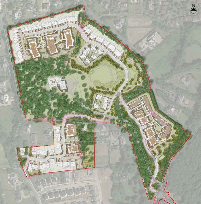
9Figure 4.1: Landscape Overall Plan
Ground plane materials within the public spaces will be restrained and consist of bound gravel for the
pedestrian walkways within the public spaces and brushed concrete for walkways adjacent to roads.
Permeable paving will be used for driveways and car parking areas.
Focal points, such as sculptural elements, specimen tree planting will also be incorporated at
appropriate locations within the project to enhance this sense of place and to assist with way-finding
through this scheme.
The perimeter boundaries are limited to existing boundaries, which will be augmented where required.
10In order to create a highly legible and therefore self-regulating environment, signage and barriers will be
kept to a minimum, thereby reducing physically intrusive measures, enhancing pedestrian and cyclist
movement and creating a more attractive public realm.
An objective of the landscape strategy is to provide opportunities for passive and active recreation, by
way of natural play/ fitness trails, play facilities and pathways through the open spaces.
These proposed pathways in addition to providing recreational opportunities will also promote
connectivity within the overall scheme and adjoining areas, including Malahide Demesne to the east.
4.2.1. Existing Woodland, Trees and Hedgerows:
(to be read in conjunction with arboriculturist’s report)
The retention of the existing woodlands, trees and hedgerows are a priority of the landscape strategy as
they strongly contribute to semi-rural and mature setting of the development and will assist in screening
the proposed structures from the adjoining lands and road, as well as providing visual amenity and
biodiversity benefits. The design of the development has where possible followed the pattern of exiting
field boundaries to ensure retention of existing woodland and mature hedgerows where possible and to
retain the historical patterns of the landscape. The existing hedgerows that are to be retained will be
pruned, tidied and replanted with native species where the hedgerow is of poorer quality.
During the construction phase the existing trees and hedgerows that are to be retained will be protected
from construction traffic, material storage, ground level changes and any other disturbances, in
accordance with the recommendations set out in BS5837: 2012 and detailed in the arborist’s report.
Figure 4.2: Auburn House - Woodlands, tree belts & hedgerows
114.2.2. Road Hierarchy and Pedestrian & Cycling Approach:
A road/street hierarchy has been developed throughout the subject lands to reinforce the character areas
and to encourage appropriate traffic speeds for cycling and pedestrians, as required (refer to engineer’s
drawings). The site layout identifies a meandering north-south road designed to encourage
cycle/pedestrian accessibility to the proposed buildings and spaces within the estate lands.
Pedestrian & Cycling Priority Approach:
A number of traffic calming measures have been used throughout the scheme to encourage more
pedestrian and cyclist traffic and create safer movement for all throughout the scheme. Some of these
measures include:
• Horizontal deflections in the form of pinch points and on-street parking
• Vertical deflections such as raised traffic tables, raised entry treatments, ramps at main junctions
which reduce vehicular speed and permit safer pedestrian crossings.
• Reduced corner radii to assist in reducing vehicular speed.
These measures are intended to create more pedestrian friendly areas that promotes more liveable
roads and encourages greater pedestrian movement between the proposed residential areas and the
adjacent opens spaces.
4.2.3. Communal apartment spaces
The apartment blocks overlook significant communal amenity spaces (including over podium slab) for
use by the residents that includes native tree planting, ground modelling, seating, shrub and lawn areas
for passive recreation.
Play facilities are proposed within the communal open spaces of Blocks 1-3, Blocks 4,5 and duplexes
in the southern part of the site.
4.2.4. Play and recreation opportunities:
Pathways have been proposed throughout the scheme to provide recreational opportunities for future
residents and which will also promote connectivity within the overall scheme and the adjoining areas
including Malahide Demesne. Within the subject site it also proposed to include natural play elements
and exercise stations, which are inclusive and suitable for a variety of ages and abilities in locations that
are suitable for the setting. The layout of the scheme has been designed so that there will be the
appropriate level of passive surveillance from the proposed dwellings overlooking the various open
spaces. ‘No-dig’ (minimal impact on tree rootzones) pathways have been proposed through the existing
woodlands to the rear of Auburn House, based off the existing historical walkways, which will provide
12passive recreational opportunities appropriate to the woodland setting. Open lawn and grassland
meadows are also provided within the public spaces to provide space for informal play and passive
recreation.
Playground facilities have been proposed within the northern and southern residential area within the
communal open spaces, that will have the appropriate level of passive surveillance. Within the central/
front field section of the proposed development a natural play trail has been proposed, that is suitable
for the setting e.g. balancing logs, boulders, mounds. A natural play area is also located within the walled
garden, benefiting from the enclosed nature of the space and retaining the existing mature trees.
Table 1: Play & Recreation Provision: Location, area & quantity of pieces of equipment
Location of play & recreation Play area in Qty. of equipment per
Character Area
area sq.m. play/ recreation area
Character Area 1 - Southern Residential Area -
123 sq.m. 4Nr
The Avenue communal space
Character Area 2 - Central Residential Area -
326 sq.m. 12Nr
The Frontfield public open space
Character Area 3 - Northern Residential -
264 sq.m. 9Nr
The Backfield communal space
Character Area 5 - Walled Garden - public open
295 sq.m. 12Nr
Streamstown space
Total 1,008 sq.m. 37Nr
(1Nr per 40 sq.m)
(Note: as per FCC requirements: total units within the proposed development: 368Nr units x 4sq.m.
of play area for every unit = 1,472sq.m. of play area required & 1Nr piece of equipment per
50sq.m. = 29Nr pieces of equipment required)
‘Safagrass’ play safety surface is proposed to all the play areas, in order to provide the recommended
safety measures while also retaining the natural aesthetic of the development’s setting. All play
equipment and safety surfacing will conform with European Standards EN 1176-1-11 and EN 1177 and
will be RoSPA certified. Further details in relation to the play and recreation proposals within the
proposed development are indicated on drawing 1489_303.
134.2.5. Lighting:
The proposed lighting throughout the scheme will be to the required LUX levels that permits the safe use
of pathways, cycleways and public open spaces, with more ambient, way finding lighting to the
communal open spaces.
It is intended that there will not be any lighting within the woodland area to the west of Auburn House –
to minimise disturbance to the existing trees rootzone to insure their successful retention within the
scheme and due to wildlife in the area.
4.2.6. SuDS:
It is intended to utilise SuDS within the proposed scheme, stormwater attenuation areas are provided
primarily above ground within public spaces and below ground in privately managed areas. SuDS
detention basins are proposed south of proposed Apartment Block 4 and within the central open space
to the east of Auburn House (refer to engineer’s drawings for further detail). Additional flood water
attenuation is also being provided through the re-profiling of the lands east of the access road within the
central part of the site. Permeable paving is also proposed as much as possible within the scheme,
along with green roofs to the apartment buildings to assist in water attenuation.
4.2.7. Biodiversity Benefits:
The proposed planting will be selected to be native species where possible, pollinator-friendly, to be low
maintenance and to maximize feeding opportunities for birds and insects. It is proposed to fix swift
boxes at appropriate locations and 21 Schwegler bat boxes (or equivalent) of varying design shall be
erected within the woodlands to provide a variety of suitable roost sites. These boxes must be away from
lighting and shall be no lower than 3 metres from ground level (refer to ecology report for further details).
‘Bug hotels’ can also be located in certain open spaces if deemed appropriate by the ecologist and local
authority.
144.3. Character Areas:
Figure 4.3: Character Areas (Source: CCK, 2022)
154.3.1. Character Area 1 - The Avenue:
Figure 4.4: Landscape Plan - Character Area 1
16Figure 4.5: Section AA
Figure 4.6: Section BB
Figure 4.7: Section CC
Tree lined approach to Malahide:
The mature tree lined road to Malahide, formed by the woodland within Malahide Demesne and in part
by tree belt along the subject land’s south-eastern boundary, is a distinguishing feature of the approach
to Malahide and contributes to the local character and landscape setting.
The FDP (2017-2023) contains Local Objective’s 55 and 57 which highlights the importance of protecting
the tree lined approach to Malahide.
It is intended that the trees located along the south-eastern boundary will be retained, apart from the
trees highlighted in the arboricultural report and survey which are in such poor health/state of decline
that it necessitates their removal.
17This tree belt will be further reinforced with additional mature tree and woodland planting where
appropriate and with the recommended species as outlined in the Woodland Management Plan, as
prepared by the arborist.
The retention of these trees is crucial to protecting the landscape setting of the subject site and to assist
in screening the proposed development from Malahide Road.
Figure 4.8: Concept Image – Parkland Landscape
Existing Entrance:
It is proposed that the existing entrance is to be retained, limiting it use for pedestrians and cyclists, with
vehicular access retained solely for existing residential use. A new vehicular entrance is proposed
immediately south of the existing entrance.
The important aspects for consideration at this location, is to achieve balance in protecting the historical
relationship and context of Auburn House’s entrance, while ensuring the necessary safety requirements
(including required sightlines), to allow for the safe access/egress to Malahide Road.
To emphasise the priority of pedestrian and cyclists, granite setts are proposed at the existing entrance
and along the avenue, past the crossover with the new entrance road.
Existing Driveway approach to Auburn House - ‘Conceal and Reveal’:
The existing driveway that provides access to Auburn House off Malahide Road was designed to conceal
views towards the house until visitors arrived at the front of the dwelling. This was achieved by the careful
curving of the driveway and strategic tree planting that prevented views towards the house but provided
glimpsed views of the surrounding landscape.
It is proposed to maintain the existing driveway in its current form to ensure that the existing character of
the drive is retained and enhanced through the provision of replacement woodland tree planting. The
18drive will form part of the perimeter walk around the estate lands including the woodland, walled garden,
stream and central park.
New access road:
The new access road has been designed to minimise the negative impact on the existing trees that
bound the existing drive to Auburn House, while facilitating the safe movement of vehicles through the
development.
Granite setts are proposed at the new entrance off Malahide Road to emphasise the entry point while
also creating cohesion with the existing entrance, through the use of similar materials.
A sculptural signage element (design and location subject to consultation with FCC), black estate railings
with hedge planting are also proposed at this new entrance, to create a sense of arrival without detracting
from the existing entrance and avenue.
Additional tree planting and strategic ground modelling is proposed to screen views of the proposed
road from the existing drive and from Auburn House.
It is proposed that the majority of the trees that form the boundary between the subject site and Malahide
Road will be retained, unless they are in very poor health or need to be removed to facilitate the
construction of the new entrance road (works to be carried out in accordance with arboriculturist’s report
and drawings). The proposed entrance off Malahide Road and the access road is discussed in more
detail in the ‘Access Assessment Report’ complied by Downey Planning Consultants.
Proposed Southern Residential Development & Opens Spaces:
The landscape strategy within this part of the proposed development is to:
• Maintain sufficient distance from Malahide Road to prevent any encroachment into the existing
mature tree belt
• Re-planting the existing tree belt to assist in screening the proposed development and to maintain
the tree lined approach to Malahide
• Maintain existing trees along the eastern boundary to protect the off-site residential amenity of
dwellings adjoining the subject lands
• Retain the woodland setting of the existing drive
• Provide pedestrian and cycle route through the scheme to link with Malahide Road
• Provide attractive communal open spaces for future residents to relax, move and/ or socialise within.
• Extensive lawn areas for passive recreation
• Play and recreation area that will provide active recreational opportunities for future residents
19• SuDS - green roofs to the apartment buildings to assist in water attenuation.
Figure 4.9: Concept Images - Residential Area
Existing Stream/ historical field boundary:
The small stream that flows east to west across the southern part of the site and the associated tree belt
is to be retained within the proposed development as it forms an important boundary as identified on
historical maps and plays a considered role in the integration of the proposed development into the
existing landscape.
Figure 4.10: Concept Images - Treatment to Communal & Open Spaces
204.3.2. Character Area 2: The Frontfield
Figure 4.11: Landscape Plan - Character Area 3
Figure 4.12: Section DD
Front field:
The front field, located to the east of Auburn House, was likely designed to create an open, pastoral vista
towards Malahide Demesne.
A key objective of the landscape strategy is to retain this important vista and to frame views from Auburn
House, by way of a well-considered tree planting scheme.
The proposed central space will provide a quality recreational area and will also form part of an attractive
pedestrian route around the estate lands which will be overlooked from the north and south by housing
units.
This space also contains a SuDS detention basin within a gently undulating landscape containing native
trees and ground modelling, open lawn and grassland meadow. The planting approach within this
21space, is to reinforce and maintain the existing vista, create visual interest and to create a sense of place,
resulting in restful and inviting spaces to encourage use by future residents.
It is also proposed to remove the more recently added circular pool to the front of the house.
Figure 4.5: Concept Images - Treatment to Front Field/ Central Open Space
Central Residential areas:
Clustered courtyard style dwellings are proposed within this part of the development, north and south of
the central open space:
• Permit a controlled and cohesive approach to the interface between dwellings and parkland space
• Hedge type planting to ‘soften’ the edges of the proposed dwellings and boundary walls
• Ornamental planting within the courtyard cluster of dwellings to provide an attractive space for future
residents
• Reinforced grass as a surface treatment to permit occasional vehicular access
• Natural stone materials – pedestrian surface and boundary treatments
• Subtle ground modelling with mature tree planting
• Assist in mitigating the visual impact from Auburn House but not from the existing drive
• Natural play trail near the eastern boundary composed of play elements that are appropriate for the
setting, such as balancing logs, boulders, play tunnel and ground modelling, with passive
surveillance from the proposed dwellings to the north and south of this space.
• Pedestrian pathway to provide passive recreational opportunities and linkages/ permeability through
the subject site
22• In order to retain the existing mature trees along the north-eastern site boundary, a fenced and gated
pedestrian trail is proposed to the rear of the dwellings.
Figure 4.6: Concept images - central play area
4.3.3. Character Area 3 - The Backfield:
A key objective in this part of the site is to protect the existing field boundaries as far as possible to:
• Maintain the setting and landscape character of Auburn House
• Retain the historical field boundary and mature trees as much as possible between Apartment Block
3 and the northern courtyard buildings and reinforce the field boundary with additional tree planting
where necessary.
• Retain the residential amenity of the surrounding dwellings that adjoin the subject site and provide
an attractive setting for future residents.
• Assist in screening the proposed development from the adjoining lands
23Figure 4.8: Landscape Plan - Character Area 3 The Backfield
Figure 4.7: Section EE
The proposed treatment to the rear of the dwellings within this part of the site includes a set-back
boundary to extend the distance of proposed the development to the existing trees and hedgerows.
Communal open spaces are provided between the proposed apartment blocks to provide:
• Amenity grass areas for people to relax, socialise and play within.
24• Specimen tree planting and ground modelling with shrub/wildflower meadow and multi-stem tree
planting to define and create interest within the spaces and to provide pleasant human scale
spaces.
• Provide seating, play and recreational opportunities
• To ensure permeability within the spaces and to provide linkages to the surrounding areas
including the woodlands
• SuDS - Green roofs proposed to the apartment buildings to assist in rainwater attenuation.
Figure 4.9: Concept Images -Treatment to Podium Areas
4.3.4. Character Area 4 – Auburn House & The Woodland:
Auburn House and curtilage:
It is proposed that Auburn House will be retained as a single dwelling as part of the development and
that additional planting and a seating area are to be provided to the south of the house, to enhance the
private amenity space of the dwelling.
Woodland to rear of Auburn House:
The existing woodland around Auburn House varies in age and condition. The original woodland is the
most imposing element of the English landscape garden within the Auburn estate and is evident on
Taylor’s 1816 map of Dublin. The original woodland would have comprised Oak, Beech Horse Chestnut,
Sweet Chestnut and Lime which are now over mature and in decline, with increasing losses over the last
20 years from winter storms. This has resulted in the natural re-generation of primarily Ash and Sycamore
replacing the planted woodland and creating an increased proportion of the woodland today.
The existing pathways through the woodland will be maintained and re-dressed for pedestrian use,
providing an attractive pedestrian route around the estate, while minimising any negative impact on the
existing trees. Where openings occur within the canopy of the woodland to the rear of Auburn House, it
is proposed that exercise equipment will be provided immediately adjacent to the pathway.
The Woodland Management Plan prepared by the arborist, will provide guidance and a strategy by which
the site’s existing and future tree population and woodland areas can be managed, maintained, restored
25and improved in a sustainable manner to accommodate the requirements of the planning authority and
all stakeholders. In accordance with the project ecologist recommendations bat boxes are proposed
within the woodland to provide a variety of suitable roost sites (refer to ecology report for further details).
4.3.5. Character Area 5 - Streamstown
Figure 4.10: Landscape Plan - Character Area 5 – The Walled Garden
26Figure 4.11: Section FF
Walled Gardens:
Walled gardens were a common feature of historic houses of the past and were once known as the
‘kitchen garden’ as vegetable and fruit trees were grown to keep the family kitchen well stocked. Auburn
was no exception and historical mapping identified an orchard within the walled garden. The walled
garden remains largely intact, although the majority of the original space is not included within the
subject application. The area contained within the application area is enclosed with limestone coursed
walls and has become overgrown with a number of re-generated trees/scrub (hazel, holly, sycamore
and ash). The intention is to retain the large specimen London Plane located in the north-eastern corner
of the walled garden. The re-generated scrub material will be removed to allow for the re-planting of new
orchard trees to re-create the original design intent. The existing openings through to the adjacent
garden will be respected and marked with pathways although they will not extend fully to the existing
accesses. The small pet cemetery with the two headstones within the garden will be relocated and
retained.
Figure 4.12: Proposed Play Equipment to Walled Garden (refer to drawing 1489_303 for full details of play provisions)
27Seating and a natural play area are proposed within the northern part of the walled garden, which will
benefit from maturity of the existing trees and the safety provided by the enclosed nature of the space.
A communal open space enclosed by hedge planting, is proposed within the central part of the walled
garden, for the future residents of Apartment Block 7 and Irish heritage orchard trees are proposed in
the southern part of the wall garden to re-create the original design intent.
Carey’s Lane: Access and residential development
• Retaining existing trees where it is feasible and in accordance with the arboriculturist’s
recommendations
• Proposed tree planting to assist in screening the proposed dwellings and infrastructure
• Use of limited palette of high quality materials that is respectful of the historical setting
Figure 4.21: Concept Images - Reinforced Grass & Street Tree Planting
285. Surface Treatments & Site Furniture:
Exposed aggregate concrete pathway:
• e.g. Pedestrian Pathways
Buff Coloured Asphalt:
• E.g. Shared surfaces
29Granite Setts:
• To entrance areas, stables courtyard and pedestrian crossings
Resin and chip surface:
• E.g. over bitmac surface to stables courtyard.
Reinforced Grass/ Grasscrete:
• To private driveways and parking bays
30Pathway – Textured/ Brushed Concrete Finish:
• E.g. to pedestrian areas with occasional vehicular traffic
Seating:
• Free-standing benches to communal and public open spaces
31Sculptural Signage & wayfinding signage
• To entrance areas (subject to consultation with FCC) and wayfinding ( within the development)
32Bollards:
• Collapsible bollards at existing entrance and avenue
External Bicycle Parking:
• Sheffield bicycle stands
6. Proposed Planting:
The planting proposals within the scheme will be employed to:
• assist in the successful integration of the proposed scheme into its landscape setting
• structured native tree planting is proposed within the spaces and along the new main central spine
road which links into the amenity spaces.
• create visual interest and a sense of place
• act as a buffer and assist in partially screening and filtering views of the proposed development from
the surrounding area e.g. adjoining residential areas, Malahide Road
• assist in defining areas and reinforcing the character of the various spaces
• provide visually attractive spaces for future residents and the local community to relax, move and/ or
socialise within
• open lawn and grassland meadows are proposed throughout the public spaces which provide
space for informal play and passive recreation.
• provide a sense of enclosure at the transitions between public areas to communal areas and the
proposed buildings, while also permitting passive surveillance of the open space areas
33• compensate for any loss/ enhance biodiversity benefits with an emphasis on pollinator friendly plant
species.
Phasing of Planting: Planting will take place on a phased basis. As the construction phase of each zone
is completed , the planting will take place by the end of the following planting season (refer to drawing
1489_307). Tree and woodland planting will take place in accordance with the Woodland Management
Plan.
346.1. Outline Planting Schedule
Figure 6.1: Planting within the public and communal open spaces will be selected from the following species:
Indicative Planting Schedule
(to be carried out in accordance with arboriculturist’s woodland management plan and the project ecologist’s
recommendations)
Species Name Specification Size (girth/ height)
Proposed Semi-mature Tree Planting
125Nr Large Specimen Trees (30-35cm girth) & 404Nr Parkland/ Medium Trees (20-25cm) to be selected from
the following:
Aesculus hippocastanum min.1.8m clear stem, RB 30-35cm; 20-25cm girth
Betula pendula/ B. pubescens min.1.8m clear stem, RB 30-35cm; 20-25cm girth
Fagus sylvatica min.1.8m clear stem, RB 30-35cm; 20-25cm girth
Pinus nigra/ P. sylvestris Feathered, RB 3 -3.5m; 2-2.5m high
Prunus avium min.1.8m clear stem, RB 30-35cm; 20-25cm girth
Quercus ilex min.1.8m clear stem, CG 20-25cm girth
Q. petraea/ Q. robur min.1.8m clear stem, RB 30-35cm; 20-25cm girth
Tilia cordata min.1.8m clear stem, RB 30-35cm; 20-25cm girth
Salix alba min.1.8m clear stem, RB 30-35cm; 20-25cm girth
Sorbus aucuparia min.1.8m clear stem, RB 30-35cm; 20-25cm girth
Proposed Street Tree Planting
73Nr Street trees to be selected from the following:
Acer campestre min.1.8m clear stem, RB 16-18cm girth
Quercus petraea min.1.8m clear stem, RB 16-18cm girth
Proposed Ornamental/ Small Tree Planting
530Nr ornamental/ small trees to be selected from the following:
Acer ginnala Multi-stemmed, RB 2.0-2.5m high
Acer palmatum Multi-stemmed, RB 2.0-2.5m high
Amelanchier lamarckii Multi-stemmed, RB 2.0-2.5m high
Magnolia grandiflora Multi-stemmed, RB 2.0-2.5m high
Orchard Tree Planting
18Nr Irish heritage orchard trees to be selected from a mix of apple, pear & plum trees
35Woodland Planting (5,840 sq.m.)
(to be carried out in accordance with the arboriculturist recommendations within the woodland management plan)
Species Name Specification Size (girth/ height)
Standard Tree Planting
Acer campestre 2xtr.,RB,fthd 8-10 cm girth; 2.5m high
Aesculus hippocastanum 2xtr.,RB,fthd 8-10 cm girth; 2.5m high
Betula pendula/ B. pubescens 2xtr.,RB,fthd 8-10 cm girth; 2.5m high
Fagus sylvatica 2xtr.,RB,fthd 8-10 cm girth; 2.5m high
Prunus avium 2xtr.,RB,fthd 8-10 cm girth; 2.5m high
Quercus petraea 2xtr.,RB,fthd 8-10 cm girth; 2.5m high
Quercus robur 2xtr.,RB,fthd 8-10 cm girth; 2.5m high
Sorbus aucuparia 2xtr.,RB,fthd 8-10 cm girth; 2.5m high
Transplants Planting
Acer campestre 2xtr.,BR,fthd 120-150cm
Aesculus hippocastanum 2xtr.,BR,fthd 120-150cm
Betula pendula/ B. pubescens 2xtr.,BR,fthd 120-150cm
Corylus avellana 2xtr.,BR,fthd 120-150cm
Crataegus monogyna 2xtr.,BR,fthd 120-150cm
Ilex aquifolium 2xtr.,RB 120-150cm ht,fthd
Pinus sylvestris 2xtr.,RB 120-150cm ht,fthd
Prunus avium 2xtr.,BR,fthd 120-150cm
Quercus petraea 2xtr.,BR,fthd 120-150cm
Native Hedging
Acer campestre 1+2,BR,fthd 120-150cm
Crataegus monogyna 1+2,BR,fthd 120-150cm
Ilex aquifolium 1+2,RB,fthd 120-150cm
Prunus spinosa 1+2,BR,fthd 120-150cm
Ornamental Hedge Planting
Fagus sylvatica 1+2,RB,fthd 120-150cm
Prunus lusitanica 1+2,RB,fthd 120-150cm
Shrub and Herbaceous Planting
Alchemilla alpina 2 litre
Anemone 'Honorine Jobert' 2 litre
Asplenium scol. 'Angustifolia' 2 litre
Buxus sempervirens 3 litre
Calamagrostis 'Karl Foerster' 3 litre
Cornus alba 'Wintersun' 60-80cm; Bareroot
Crocosmia ' Lucifer ' 3 litre
Digitalis grandiflora 'Carillon' 3 litre
36Echinacea purpurea 'White Swan' 3 litre
Helleborus or. 'Montsegur' 3 litre
Helleborus orientalis (white) 2 litre
Libertia grandiflora 3 litre
Liriope muscari 'Monroe White' 2 litre
Luzula nivea 3 litre
Miscanthus sinensis 'Gracillimus' 3 litre
Panicum virgatum 'Heavy Metal' 3 litre
Pennisetum alop. 'Hameln' 3 litre
Perovskia atriplicifolia 'Blue Spire' 3 litre
Persicaria amp. 'Fat Domino' 2 litre
Polystichum set. 'Herrenhausen' 3 litre
Rosa 'Flower Carpet' (whilte) 3 litre
Rudbeckia f. v. sul. 'Goldsturm' 3 litre
Salvia nem. 'Caradonna' 3 litre
Salvia nem. 'Schneehugel' 3 litre
Stipa tenuissima ‘Ponytails’ 3 litre
Tiarella cordifolia 3 litre
Verbena bonariensis 'Lollipop' 3 litre
Vinca minor 'Gertrude Jekyll' 1 litre
Bulb Planting:
Allium hollandicum c. vars
Allium 'Purple Sensation'
Anemone blanda
Crocus cvs
Galanthus nivalis (of Irish provenance only)
Hyacinthoides non-scripta (of Irish provenance only)
Narcissus c.vars (3 approx.)
Tulipa ‘White Triumphator’
Turfgrass
10% Agrostis castellana (Highland Browntop Bent)
10% Agrostis capillaris (Browntop Bent)
40% Festuca pratensis (Meadow Fescue)
40% Festuca rubra (Red Fescue)
Wildflower/ Native Grass Areas
Planting to wildflower meadow areas – biodiversity/ pollinator friendly species seed mix. Species to be
selected in accordance with Project Ecologist recommendations.
Abbreviations:
RB – root-balled
BR - Bareroot
CG – container grown
xtr. – number of transplants in nursery
cm g. – girth of tree in centimetres measured 1m above ground
ltr cg. – plants supplied in e.g. 2 litre volume containers
377. Outline of Operations
Ground preparation will precede planting and will include weed clearance and amelioration where necessary.
There will be a period of 12 months defects liability on all planting with plant failures being replaced in the
following planting season.
Chemical use: due to the creation of the Nature Park and the site’s proximity to the estuary all use of chemicals,
such as herbicides, pesticides and fertilizers will require prior approval by the project ecologist and landscape
architect.
Herbicide and Pesticide usage must be carried out in accordance with:
S.I. 155 of 2012 - European Communities (Sustainable Use of Pesticides) Regulations 2012
S.I. 159 of 2012 - European Communities (Plant Protection Products) Regulations 2012
PLANTING
Materials
All plant material shall be good quality nursery stock, free from fungal, bacterial or viral infection. Aphis, Red
Spider or other insect pest, and physical damage. It shall comply with the requirements of the following
sections of B.S. 3936, Specification for Nursery Stock, where applicable:
Part 1 - 1992: Specification for trees and shrubs
Part 2 – 1990: Specification for roses
Part 4 – 2007: Specification for forest trees, poplars and willows
Part 7 - 1989: Specification for bedding plants
Part 9 - 1998: Specification for bulbs, corms and tubers
Part 10 - 1990: Specification for ground cover plants
All plants shall have been nursery grown in accordance with good practice and shall be supplied through the
normal channels of the wholesale nursery trade. They shall have the habit of growth that is normal for the
species.
Except for any cultivated varieties or exotic species which do not set viable seed in Ireland, all plants shall
have been grown from seed.
The Contractor will be deemed to have advised his suppliers of the relevant sections of this specification,
including all protection required, at the time of enquiry and shall in all cases be liable to replace materials
brought on site which are not in accordance with this specification.
Species
All plants supplied shall be exactly true to name as shown in the plant schedules. Unless stipulated, varieties
with variegated or otherwise coloured leaves will not be accepted, and any plant found to be of this type upon
leafing out shall be replaced by the Contractor at his own expense.
Bundles of plants shall be marked in conformity with the relevant part of B.S. 3936. The contractor shall
replace any plants that are found not to conform to the labels. An inspection of plants shall be undertaken
prior to planting to ensure quality control.
38Extra Heavy Standard and Standard Trees
Extra Heavy Standard trees shall have a total height of 4.0 to 4.5 metres and a girth of 14-16 cm at 1m above
ground level. Standard trees shall have a clear stem 1.70 m to 1.85 m in height from ground level to the lowest
branch, a minimum girth of 8 cm measured at 1m above ground level and a total height of 2.5 to 3.0 metres.
Trees shall have a sturdy, reasonably straight stem, a well defined and upright central leader, with branches
growing out of the stem with reasonable symmetry, or a well balanced branching head according to the
Schedule. The crown and root systems shall be well formed and in keeping with the nature of the species.
Roots shall be in reasonable balance with the crown and shall be conducive to successful transplantation.
Trees shall be supplied bare rooted unless otherwise specified. They shall have been regularly undercut or
transplanted. They shall have been lifted carefully to avoid tearing of major roots and to preserve a substantial
proportion of smaller and fibrous roots. Trees shall have been grown on their own roots. Budded or grafted
trees will be rejected.
Transplants
Transplants shall not be less than three years old, and shall have been transplanted at least once. Trees of
species not listed in B.S. 3936: Part 4: 1984 shall be sturdy, with a balanced root and shoot development.
Sizes shall range from 600-900 and 900-1200 mm.
Trees shall be well furnished with lateral and fibrous roots, and shall be lifted without severance of major roots.
Roots shall be of the habit normal for the species.
Salix shall have been stumped and transplanted at the end of the first year in the nursery.
Shrubs
Shrubs shall be of the minimum size specified in the schedules, with several stems originating from or near
ground level and of reasonable bushiness, healthy, well grown, and with a good root system. Pots or
containers shall be as scheduled. Plants shall not be pot bound, nor with roots deformed or restricted. Bare
root material will only be accepted where specified.
Herbicides
Chemical use – due to the creation of the Nature Park and the sites proximity to the estuary all use of
chemicals, such as herbicides, pesticides and fertilizers will need require prior approval by the project
ecologist and landscape architect.
Within the proposed Nature Park the use of herbicides and pesticides should be minimised.
Where species is deep rooted and cannot be removed manually or is persistent it should be treated with
localised and spot application of hormone weed killers.
Weedkiller Application
All weedkiller handling and application should be carried out in accordance with the manufacture’s
instructions, COSHH Regulations, using the necessary PPE and by trained personnel only.
Bulky Organic Manure/ Mushroom Compost
39Bulky organic manure shall consist either of spent peat compost, mushroom compost, as described above,
spent hops, or of well rotted farm manure. Farm manure shall consist of predominantly of faecal matter and
shall be free of loose, dry straw and of undigested hay. Manure shall be free of surplus liquid effluent. This
shall be used on mounds only. Well spent mushroom compost shall be used in all ornamental planting areas.
Fertilisers
Controlled release fertiliser N:P:K 15:9:11 plus trace elements - Osmocote plus or similar approved applied
at specified rates.
Fertiliser shall be supplied in sealed bags or containers bearing the manufacturer's name, the net weight and
analysis.
Stakes for Standard Trees
Stakes shall be of peeled larch, pine or Douglas fir, preserved with water-borne copper-chrome-arsenic to I.S.
131, to a net dry salt retention of 5.3 kg. per cubic metre of timber. Stakes shall be turned, and painted one
end. Sizes shall be as follows:-
for extra heavy standard trees: 2700 x 75 mm dia.
for standard trees: 2700 x 75 mm dia.
Set stakes vertically in the pit, to the western side of the tree station, and drive before planting. Drive stake
with a drive-all, wooden maul or cast-iron headed mell, not with a sledge hammer.
Tree Ties
Tree ties shall be of rubber, P.V.C. or proprietary fabric laminate composition, and shall be strong and durable
enough to hold the tree securely in all weather conditions for a period of three years. They shall be flexible
enough to allow proper tightening of the tie.
Ties shall be min. 40 min. wide for standard trees. Provide a simple collar, free of rough or serrated edges,
to prevent chafing. Provide for subsequent adjustment of the tie either by means of a buckle (nail tie to stake
immediately behind it) or by leaving heads of securing nails slightly proud, to permit easy extraction and
repositioning. All nails shall be galvanised.
Protection
The interval between the lifting of stock at the nursery and planting on site is to be kept to an absolute
minimum. Plants shall be protected from drying out and from damage in transport. All stock awaiting planting
on site shall be stored in a sheltered place protected from wind and frost, from drying out and from pilfering.
Bare rooted plants not immediately required shall be heeled-in in a prepared trench, the bundles of plants first
having being opened, the plants separated and each group separately heeled-in and clearly labelled. The
roots shall be covered with moist peat or soil and shall be kept moist until planted. Pots shall not be removed
until plants have been carried to their planting station. Plants packed in polythene must be stored in shade.
All forest transplants and bare root shrubs shall be wrapped in polythene from the time of lifting to conserve
moisture. Except when heeled-in, they shall be protected in polythene at all times until planted into their final
position on site.
40You can also read