Lower Trent & Erewash Catchment Management Plan 2019
←
→
Page content transcription
If your browser does not render page correctly, please read the page content below
Lower Trent &
Erewash
Catchment
Management Plan
2019

             1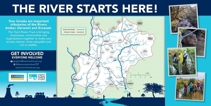
Lower Trent & Erewash Catchment
       Management Plan

         Written on behalf of the

Lower Trent & Erewash Catchment
           Partnership

                                    2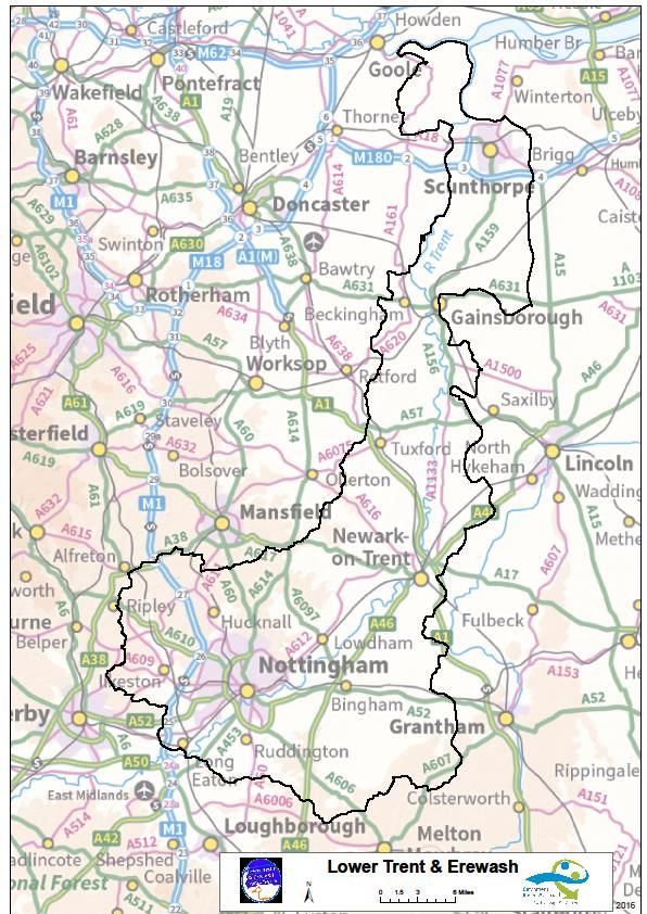
1 Introduction
1.1 Purpose of this document
This document provides the baseline to take forward the work of the Lower Trent &
Erewash Catchment Partnership. It describes the Lower Trent & Erewash catchment
and the issues that need to be tackled. Wherever available, a data and evidence
approach has been used to support the areas and project identified for future
development.

The summary tables (Section 4.2) show the multiple benefits for each project against
the Lower Trent & Erewash Catchment Partnership goals. Annex 3 contains the
specifications for each project including the current status of the project; the lead
organisation and next steps required to make it happen.

1.2 The Catchment Based Approach
Back in 2012 Defra launched the Catchment Based Approach (CaBA). The
Catchment Based Approach encourages organisations to manage land and water in
a balanced way, by identifying the pressures on the water environment, by working
together to agree common objective and by implementing solutions. A key principle
is encouraging organisations to work in partnership and to deliver a range of benefits
through a single initiative.

1.3 River Lower Trent & Erewash Catchment
The catchment of the Lower Trent and Erewash is a very large sub catchment
covering an area of approximately 2045km2, extending from the River Dove
confluence with the River Trent south west of the city of Derby and finishing at
Alkborough Flats where the Trent flows into the Humber Estuary at Trent Falls.
Within this area the River Trent is 174 km long with its main tributaries including the
rivers Derwent, Soar, Erewash, Leen, Greet, Devon, Idle, Torne and Eau and the
Dover Beck. Nottinghamshire is its principal county, with parts of Derbyshire,
Leicestershire, Lincolnshire, South Yorkshire and North Lincolnshire incorporated.

The catchment is a very long one touching a number of counties and to better
service its needs the south west corner between its confluences with the Rivers
Dove and Derwent is being managed by the Derwent Catchment Partnership. This
plan will therefore cover the catchment immediately downstream of its confluence
with the Derwent to the Humber Estuary.

Nottingham is the principal urban area within its catchment with other major
settlements being Ilkeston, Newark, Gainsborough and Scunthorpe.

The catchment contains a variety of landscapes, predominantly the Trent and Belvoir
Vales but also includes the Humberhead Levels, the Northern Lincolnshire Edge and
Nottinghamshire and Leicestershire Wolds. The bedrock geology of Triassic and

                                                                                          3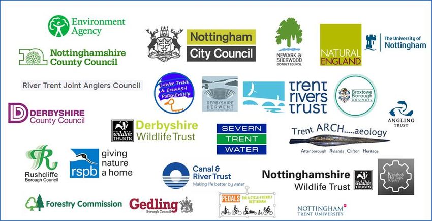
Jurassic mudstones has given rise to fertile, clayey soils across much of the area,
while extensive deposits of alluvium and sand and gravel have given rise to a wider
variety of soils, especially in the flood plains. The dominant land use across the
catchment is rural, mostly arable production with a small portion in pasture. Diffuse
nutrient pollution (phosphate) from agricultural run-off is considered to be a major
contributing factor to the overall WFD status of the catchment.

Other key issues causing water quality problems come from overflow from sewage
works, surface water run-off from quarry workings and the road network. There are
also some communities at risk of flooding within the catchment.

Before CaBA there were already many projects ongoing across the Lower Trent that
delivered benefits for the water environment. However, few of them looked at the
catchment as a whole. The Lower Trent & Erewash Catchment Partnership has
brought many well established organisations together to discuss their work and
future aspirations at the catchment scale. The work reinforces the strength of some
of the existing projects and allows the partners to look more widely at opportunities
to work with partners to bring about benefits that may not be achievable by working
alone.

                                                                                        4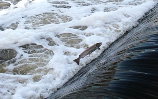
Figure 1 Map of the Lower Trent & Erewash Catchment

                                                      5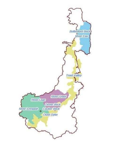
2 The Lower Trent & Erewash Catchment Partnership
The Lower Trent & Erewash Catchment Partnership has been developed in
response to the Defra Catchment Based Approach policy using funding by Defra and
the EA. A range of organisations have been meeting to look at the options across the
Lower Trent & Erewash since the start of 2014.

The Lower Trent & Erewash catchment partnership has a wide and active
membership. The Catchment Based Approach has brought a catchment scale focus
to the members recognising the wider benefits that can be achieved by a
coordinated partnership. The organisations that attend the meetings are listed below:

Ashfield District Council
Canal and River Trust
Broxtowe Borough Council
Derbyshire Wildlife Trust
Derbyshire County Council
Environment Agency
Forestry Commission
Friends of Toton Fields
Gedling Borough Council
Groundwork Nottingham
Keep Britain Tidy (via WatersideCare)
Lincolnshire Wildlife Trust
Nottingham City Council
Nottinghamshire County Council
Nottinghamshire Wildlife Trust
National Farmers Union
Natural England
North Lincolnshire County Council
Nottingham Trent University
RSPB
Rushcliffe Borough Council
Severn Trent Water
Southwell Flood Forum
Trent Rivers Trust (catchment host)
Trent Valley IDB
U3A
University of Lincoln

                                                                                   6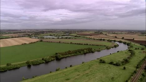
2.1 Lower Trent & Erewash Catchment Vision
The Lower Trent & Erewash catchment partnership has an agreed vision for the long
term on the Lower Trent & Erewash.

         Vision for the Lower Trent & Erewash Catchment Partnership

        "A Lower Trent & Erewash catchment that has a healthy, functioning
            water environment including rivers, lakes and groundwater”.

2.2 Lower Trent & Erewash Catchment Partnership Objectives
 Objective                   Long term objectives
 Biodiversity and Natural    There is a rich and diverse collection of habitats and
 Processes                   species within the catchment rivers and their floodplains.

                             Areas of high conservation value are in good condition and
                             are connected by wildlife corridors.

                             Fish can move freely throughout the catchment with ample
                             spawning and nursery areas.
 Flood Risk Management       Rain water is stored and managed to reduce the risk of
                             flooding through the use of urban and rural sustainable
                             drainage solutions wherever possible.

                             Properties and livelihoods are not impacted by flood risk
                             and are resilient to future climate change.

                             Floodplains are managed to store flood water as well as
                             other local benefits.

                             Opportunities for Natural Flood Management (NFM)
                             schemes are explored and implemented where possible.
 Community Involvement       There is a high level of public understanding of the
 and Recreation              importance of rivers and floodplains to provide places for
                             people and wildlife.

                             Communities are involved with a local river project.

                             There is a range of recreation and accessible sites along
                             the river and throughout the catchment.
 Water quality               Water quality from point and diffuse sources is improved.

                           There is a raised awareness of pollution risk from
                           residential, commercial, rural and urban sources.
 Addressing issues in high Our priority areas benefit from focused attention to help
 priority areas within the them achieve relevant catchment objectives.
 catchment
                           Partners supporting each other and working together in our
                           priority areas to maximise achievements.

                                                                                          7
2.3 Our Priority Areas
The Lower Trent & Erewash catchment is a very large and long catchment with
major urban communities separated by long distances e.g. Nottingham near the
south of the catchment is over 70 miles from Scunthorpe in the North. Rural
communities are similarly spread and so lack a sense of shared ownership and
engagement over the catchment as a whole.
The use of priority areas or hubs better enables the engagement of partners as well
as local communities to work together to improve the water quality. Four priority
areas have been identified in the catchment:
Trent Valley (Trent Gateway project area)
Erewash and Leen
Dover Beck and Greet
Bottesford Beck and Eau
From these areas 2 Hubs have been created that allow the partnership to work
together to help achieve the catchments objectives. These Hubs are the Erewash
and Leen Hub and the Rural Hub which includes the Trent Valley and Dover Beck
and Greet priority areas. The overall Catchment Partnership is overseen by a
steering group formed from Trent Gateway Project partners.
The Trent Gateway project is a large landscape scale project across the catchment
(Figure 3) which brings together heritage, access and recreation, education and
environmental sectors to deliver coordinated benefits. The Trent Gateway project will
restore the River Trent to a thriving green corridor, focussing on enabling fish
passage to over 400km of river. Through working in partnership, the project will also
deliver a range of recreational and economic benefits by linking the people to the
social history of the area and the role the Trent has played in shaping the
communities along its route More information on the project can be found at:
https://www.trentriverstrust.org/lower-trent-and-erewash/trent-gateway/lower-trent-
and-erewash-trent-gateway/
Partners currently have projects and/or potential projects in the Hubs and this
provides a core of activity on which to build. Section 3 below provides further
evidence of the issues in the Hubs that the partnership could work together to
address.
8
Figure 2 Map of the Hubs

                           9
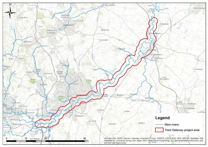
Figure 3 Map of the Trent Gateway project area

                                                 10
3 Data and evidence
3.1 Nationally consistent evidence base
CaBA data package for Lower Trent & Erewash catchment:
https://catchmentbasedapproach.org/learn/national-evidence-desktop-caba-gis-data-
package/ The 'CaBA Data & GIS User Guide' explains which layers are available,
what they mean and how they can be used. There are over 100 data layers available
for this catchment which identify the spatial pattern of opportunities; issues,
characteristics and the possible sources of the issues. This weight of evidence is
being improved by collecting local datasets and working with local organisations in
the catchment. This data coupled with 'Local Evidence' and 'Priority Places' below
provide the weight of evidence required to deliver projects which will benefit the lives
of people and wildlife living in this the catchment.
3.2 Local Evidence
In addition to the national datasets available in the CaBA data package and via
government open data initiatives, local data and evidence (including modelling) is
important for helping to pinpoint issues, identify solutions and monitor outcomes in
our catchment.
Details of key monitoring and modelling resources and tools which are being used in
this catchment can be found in Annex 7.1
3.3 Priority places
A number of key CaBA organisations are prioritising where they will undertake
actions to meet their particular aims, and these actions can potentially impact on
other aspects of the water environment. We have used the following resources to
help the partnership focus delivery where it will bring the greatest benefit:
3.3.1 Catchment Data Explorer
http://environment.data.gov.uk/catchment-planning/ManagementCatchment/3052
This is central to the CaBA planning process and we have used it to help identify
where the issues are and the likely causes. Below is an extract for the Lower Trent
and Erewash Catchment but details on all sub-catchments and water bodies can be
found at the above link.
11Number of water bodies in this Management Catchment
Water body categories Natural Artificial Heavily Total
modified
River, canals and surface water 54 3 16 73
transfers
Lake 2 7 1 10
Coastal 0 0 0 0
Estuarine 0 0 0 0
Groundwater 0 0 0 0
Total 56 10 17 83
Ecological and chemical classification for surface waters | 2016 Cycle 2
Ecological status or potential Chemical status
Number of water bodies Bad Poor Moderate Good High Fail Good
83 3 138 59 3 0 0 83
Summary of ecological status or potential and chemical status and objectives for
surface water bodies (number of water bodies) including those with less stringent
objectives and extended deadlines (blue shaded cells)
Ecological status or potential Chemical status
Bad Poor Moderate Good High Total Fail Good Total
By 2015 1 3 22 6 0 32 0 83 83
By 2021 0 0 0 2 0 2 0 0 0
By 2027 0 1 5 43 0 49 0 0 0 Extended
Deadline
Beyond 2027 0 0 0 0 0 0 0 0 0
Total 1 4 27 51 0 83 0 83 83
Less Stringent Less Stringent
Reasons for not achieving good status (RNAG) and reasons for deterioration in this
Management Catchment are detailed below.
The table below shows the number of reasons for not achieving good status
(RNAGS) and reasons for deterioration (RFD), split by sector.
12Sector RFD RNAG Grand
Total
Agriculture and rural land management 2 117 119
Domestic General Public 0 9 9
Industry 0 14 14
Local and Central Government 0 10 10
Mining and quarrying 0 8 8
Navigation 0 4 4
No sector responsible 2 15 17
Other 0 2 2
Recreation 0 0 0
Sector under investigation 1 24 25
Urban and transport 2 54 56
Waste treatment and disposal 0 2 2
Water Industry 7 129 136
Grand Total 14 388 402
The tables show that the catchment is failing on Ecological Status and that after
water companies, rural land management is a large contributor to the reasons for
failure.
3.3.2 Catchment Flood Management Plan
https://www.gov.uk/government/publications/river-trent-catchment-flood-
management-plan we have used this to check planned actions for reducing flood
risk in this catchment in order to identify opportunities to create multi-benefit actions,
and to identify opportunities to add flood risk benefits to other planned projects.
3.3.3 Countryside Stewardship Statements of Priorities
https://www.gov.uk/government/collections/countryside-stewardship-statements-of-
priorities We have used this to identify where Natural England has identified water
quality or flooding as a priority issue for allocation of countryside stewardship grants.
3.3.4 Local Authority spatial plans:
Greater Nottingham: http://www.nottinghamcity.gov.uk/planning-and-building-
control/planning-policy/the-local-plan-and-planning-policy
Newark and Sherwood District Council: http://www.newark-
sherwooddc.gov.uk/corestrategy/
North Lincolnshire: http://www.northlincs.gov.uk/planning-and-environment/planning-
policy/local-plan/north-lincolnshire-local-plan/
We have used these to identify where green infrastructure measures could be
targeted, and funded from infrastructure levy, to provide flood risk, water quality,
biodiversity and recreational benefits.
3.3.5 Severn Trent Water RSA plan.
We have used this to understand where the priorities are for Severn Trent Water and
identify opportunities for partnership working.
133.3.6 Nottinghamshire Biodiversity Group Biodiversity Opportunity Mapping:
http://www.nottsbag.org.uk/projects.htm. We have used this to understand where the
priorities are for biodiversity, particularly wetland habitats, and identify opportunities
for partnership working to address these issues.
There are many organisations looking to prioritise where they spend money and
undertake actions to provide the best outcome for their particular objectives. The best
way to make use of these different prioritisation tools and plans is to use them in
combination to identify areas of the catchment, and possible projects, which will
provide benefits to multiple partners, as this will provide a strong business case for
future funding bids.
3.3.7 Minerals Local Plans
We have used the Nottinghamshire Minerals Local Plan to identify the scope for the
delivery of wetland habitat at a landscape scale via post minerals development.
The RSPB Bigger and Better vision for 2050 builds on this with recognising the value
of a linked up network of wetland habitats. We have used the RSPB Futurescapes
documents https://www.rspb.org.uk/Images/biggerandbetter_tcm9-401346.pdf and
https://www.rspb.org.uk/Images/futurescapes-newark-to-south-clifton-concept-
plan_tcm9-416261.pdf to help identify areas of priority.
143.4 Justification for the Priority Areas
3.4.1 River Erewash and River Leen Catchments
The River Erewash is made up of 10 waterbodies 2 of which are at Poor
status, the remainder of which are Moderate Ecological status. The River
Leen waterbodies are at Moderate Ecological status.
Both of these catchments have established community engagement from
Friends of Groups and previous projects.
Within the River Leen flooding is an issue on the Day Brook.
The Catchment Flood Management Plan (see above) categorises the
Erewash as needing actions to reduce flood risk.
The Broxtowe Biodiversity Opportunity Mapping (BOM) shows that within the
Erewash Valley there are significant opportunities for wetland habitats being
creation, enhancement, enlargement and reconnection:
In the Ashfield BOM the value of the Leen Catchment as a focal area having
the potential for improving the existing wetland network along the River Leen
and its tributaries is highlighted. The Sherwood BOM also recognises the
value of enhancing the existing wetland habitat network along the Leen:
A restoration plan has been developed for the Erewash with partners. This
plan will form the basis of project and funding bid development to ensure a
coordinated approach across the Erewash catchment.
3.4.2 Dover Beck and River Greet
The Dover Beck is at Moderate status but the River Greet is at Poor status.
Both catchments have flooding issues that need addressing.
Work has been undertaken in engaging landowners in addressing some of the
issues from agriculture. Agriculture is the 2nd highest cause of Reasons for
the Failing to meet WFD status of good, in the catchment. The Hub could
provide opportunity to continue and extend the work already carried out to a
wider rural area.
A restoration partnership has been set up to identify and target issues in the
Greet catchment. A catchment restoration plan has been written, which will be
used to further develop projects and funding bids.
The Dover Beck has been identified as a priority for Seven Trent Water and
forms part of their local RSA.
All of the above points make this a suitable Hub to build on work already
undertaken in the catchment and address WFD and partner issues.
3.4.3 Bottesford Beck
Bottesford Beck is at Moderate status.
15 It has a very active Friends of Bottesford Beck group that have been
successful in raising funds and carrying out works both on the Beck and
adjoining community sites.
This Hub is coordinated by the North Lincolnshire management group and
provides the opportunity to support this group and work with neighbouring
groups such as that at Scotter.
3.4.4 Trent Valley / Trent Gateway
The Trent Valley and Trent Gateway project links the other Hubs and provides
opportunity to develop catchment scale funding for projects on the Trent.
The Trent Gateway project aims to make major improvements to the River
Trent between Cromwell near Newark and Sawley, near Long Eaton. The
Trent Gateway project aims to enable fish passage on some of the largest
weirs in the UK.
The plans for the Trent will open up 410km of main river plus more smaller
tributaries for all species. This has the potential to improve up to 244
upstream waterbodies.
Trent Gateway is a long-term ambition and the partnership (with the steering
group) will work together in a strategic approach to look for ways the river can
be restored for both wildlife and people. By taking an approach of using the
River Trent as a catalyst for regeneration and improving health we hope we
can attract investment from a wide variety of funders and sectors who have an
interest in the River Trent.
The Trent Valley BOM maps indicate that wetland habitats are considered to
be the habitats which should be subject to most activity, with considerable
opportunities identified for the re-creation of extensive areas of reedbed and
wet grassland within the Trent Valley.
http://www.nottinghamshire.gov.uk/media/111899/the-trent-valley-bom-
project-report.pdf
The Rushcliffe BOM maps also indicate that there are considered to be a
number of opportunities for wetland habitats both enhancing existing sites and
connecting them in the floodplain of the Trent Valley river catchments and its
tributaries.
The Nottinghamshire Minerals Plan and RSPB Bigger and Better visions
supports the landscape level development of post mineral wetland habitats in
the Trent Valley – see section 3.8.8 above.
164 Projects for delivery
A series of ‘Delivery Projects' have been developed by the Lower Trent & Erewash CP
group since it started meeting. This working document identifies these projects and
provides a draft specification for the work. As the partnership has discussed the
projects, those with the most backing have been developed further, while others with
less backing have been dropped.
4.1 General principles used to identify and prioritise ‘Delivery Projects’
for the Lower Trent & Erewash Catchment
The general principles used to identify these projects are listed below:
At the events held at Gainsborough and Flintham in February 2014 a long list
of projects were identified by the partners
This list has been discussed, revised and refined during a number of meetings
and partner discussion. Other projects have been added to the list as new
stakeholders have become involved in the partnership.
This approach ensures that the limited resources of the CaBA partnership are
used to develop projects which attract the most support from the group.
The approach is all about direction of travel, rather than achieving a threshold
water quality or ecological status. This is makes the use of evidence much
simpler and easier to understand.
The rivers in the catchment are highly modified with significant industrial and
urban pollution. Catchment scale water quality and overall habitat are likely to
be very difficult to bring back in a way that will give high quality ecology due to
multiple upstream sources of pollution and pressure.
The projects are on rivers, groundwater and reservoirs where there will be
multiple benefits.
The CaBA Data and GIS package has been used with summary and water body
documents to focus in on the main opportunities which will bring multiple
benefits.
Preference is given to opportunities in areas where there is already some
activity which can be built on; it is easier to make progress when activity has
already started on the ground.
+++ indicates the main rationale behind a project, it does not mean that the
project will deliver big improvements.
++ indicates secondary benefits from the project.
+ indicates minor benefits from the project.
The summary table below could be used to change or refine the suggested
projects, in consultation with the Hubs and steering group, to better deliver the
catchment strategy.
All 'Delivery Projects' should deliver benefits for WFD as well as CaBA if they
are to be supported by the Environment Agency.
Each project should have a 'lead partner’ to drive it forward.
174.2 Projects Summary Table
The summary table attached shows the multiple benefits for each project against
Lower Trent & Erewash Catchment Partnership Objectives. Section 4.3 contains
details of the Flagship projects.
Projects can be put forward by completing the project template or by using the online
portal which can be found here
The project ideas are discussed at Hub meetings and the priority of projects updated
following these meetings.
.
184.3 Flagship projects
4.3.1 Trent Gateway - restoring sustainable movement of people and wildlife in the Lower
Trent
The scale of the ambition of Trent Gateway is large and aims to deliver a functioning
watercourse that reduces flood risk, creates habitats as well as supporting the sustainable
growth and the local economy across 75km of the river. There are also opportunities where
the High Speed Rail network (HS2) will cross the River Trent near Long Eaton. Trent
Gateway presents a great opportunity to deliver multiple benefits across the whole Trent
catchment working with a large number of partners and communities.
It aims to remove barriers to fish migration on some of the largest weirs in the UK to enable
all fish species passage to the upper catchment as well as explore opportunities for Natural
Flood Management (NFM) and Working with Natural Processes (WwNP). The project will
engage with people and communities through a variety of experiences, to improve access
and to learn about the social history to explore the part the River Trent played in shaping the
towns and villages along its route.
The Trent Gateway partnership will make a significant contribution to the ambition of the
Lower Trent & Erewash Catchment Partnership hosted by Trent Rivers Trust. It includes
key stakeholders with interests in the sustainable development and enhancement of the
River Trent.
Vision: To create a thriving river corridor for fish, wildlife and people along the River Trent,
achieved through collaboration and engagement with communities and partners.
194.3.2 The River Starts Here – Upper Reaches of Erewash catchment
Trent Rivers Trust is bringing businesses, communities and organisations together to make
these urban headwaters cleaner, more enjoyable and better for wildlife. There is a great
deal going on in the project area, which spans the watershed of upper Erewash and the
River Derwent (https://www.trentriverstrust.org/project/the-river-starts-here).
From habitat projects like the set-back outfall, which creates great habitat for wildlife
including water voles and is popular with the public to our River Friendly Business Awards
(https://www.youtube.com/watch?v=QM3-bVsBZNo&feature=youtu.be).
Trent Rivers Trust have been working with volunteers, for example at Carr Wood in Ripley,
making a new path along a small brook and lake. The project brings together people who
have additional difficulties with local ‘Friends of’ groups and business volunteers so that
more people can enjoy these small brooks and feel a sense of ownership and connection to
them.
Part of the project includes monitoring the health of our brooks by examining the
invertebrates living in them, or by carrying out an Outfall Safari to check and report on local
pollution so that it can be addressed (https://catchmentbasedapproach.org/learn/alfreton-
brook-outfall-safari).
The project has been running in the Erewash for 18 months, with funding from the Esmee
Fairbairn Foundation and Greggs Foundation. It is set to last until at least December 2021
whereby Trent Rivers Trust will be aiming to secure more funding to build on its success.
205 Monitoring and Evaluation
The partnership needs to monitor and evaluate the work that is done in the Catchment
As each project is developed, relevant monitoring needs should be included in a monitoring
plan and results recorded. Additional evaluation can be brought in at a catchment or Hub
level.
6 Work in progress
This plan is work in progress and will grow and adapt as the partnership and hubs deliver
projects to improve the catchment and as new threats emerge. The greater the collaboration
between CaBA partners, the more sustainable this plan will become, and the greater the
benefits to the catchment and the people and wildlife that live there.
Component of CaBA Plan Initial Growing Sustainable
1) Vision and Objectives √
2) Data & Evidence √
3) Project plan √
4) Monitoring plan √
6.1 Local Evidence tools and resources
MyScimap: https://my.scimap.org.uk A free online version of the sediment risk mapping
tool.
Farmscoper: http://www.adas.uk/Service/farmscoper Decision support tool for agricultural
pollution management planning
Freshwater Watch water quality survey toolkit, training and data management: From
Feb/March 2017, FreshwaterWatch CaBA groups will have the ability to brand their own
landing page and display maps with just their own group results.
https://freshwaterwatch.thewaterhub.org/
6.2 Project Specifications
The next stage is to provide full details of project on line. Location of projects can be found
here
21You can also read