MADERA STATION RELOCATION PROJECT - San Joaquin ...
←
→
Page content transcription
If your browser does not render page correctly, please read the page content below

Madera Station Relocation Project                             Initial Study/Mitigated Negative Declaration
     San Joaquin Joint Powers Authority

MADERA STATION
RELOCATION PROJECT

APPENDIX A
BIOLOGICAL RESOURCES
TECHNICAL MEMORANDUM

SAN JOAQUIN JOINT POWERS
AUTHORITY

January 2021

     June 2020                      ADMINISTRATIVE DRAFT – SUBJECT TO CHANGE                           Page | i
Appendix A
                 Biological Resources
               Technical Memorandum

Madera Station Relocation Project

                                  Prepared for:
           San Joaquin Joint Powers Authority

                               949 Channel Street
                               Stockton, CA 95202

                                    Kaiser Center
                                 300 Lakeside Dr
                               Oakland, CA 94612

                                 January 2021
Madera Station Relocation Project                                                   Biological Resources Technical Memorandum
San Joaquin Joint Powers Authority

                                                Table of Contents
1.      INTRODUCTION ........................................................................................................ 1
2.      PROJECT DESCRIPTION .......................................................................................... 1
3.      METHODS................................................................................................................ 17
4.      ENVIRONMENTAL SETTING................................................................................... 18
5.      SENSITIVE BIOLOGICAL RESOURCES ................................................................. 19
6.      SPECIAL-STATUS SPECIES ................................................................................... 19
7.      SENSITIVE NATURAL COMMUNITIES AND HABITATS......................................... 19
8.      REGULATORY SETTING ......................................................................................... 20
9.      THRESHOLDS FOR BIOLOGICAL RESOURCES ................................................... 20
10.     POTENTIAL IMPACTS ............................................................................................. 20
11.     RECOMMENDED MITIGATION MEASURES .......................................................... 29
12.     REFERENCES ......................................................................................................... 39
13.     ATTACHMENTS…………………………………………………………………………….41

January 2021                                                                                                                 P a g e |i
Madera Station Relocation Project                                                 Biological Resources Technical Memorandum
San Joaquin Joint Powers Authority

                                                          Figures
Figure 2-1         Proposed Project Environmental Footprint ..................................................... 2

Figure 2-2         Proposed Design for Project Phase 1 – San Joaquins Relocated
                   Station (Overview) ........................................................................................... 4

Figure 2-3         Proposed Design for the Project Phase 1 – San Joaquins Relocated
                   Station (Detailed View) .................................................................................... 7

Figure 2-4         Proposed Design for the Project Phase 2 – HSR Interim Operating
                   Segment Station (Overview) ............................................................................ 8

Figure 2-5         Proposed Design for the Project Phase 2 – HSR Interim Operating
                   Segment Station (Detailed View) ..................................................................... 9

Figure 2-6         Proposed Design for the Project Phase 2 – HSR Interim Operating
                   Segment Station (Station Close-In View) ....................................................... 10

                                          Attachment A Figures
Figure 1           Regional Project Location.............................................................................. 42

Figure 2           Project Footprint ............................................................................................ 43

Figure 3           Special Status Plant Species ......................................................................... 44

Figure 4           Land Cover and Cover and Habitat Map (1 of 5) ........................................... 45

Figure 5           Land Cover and Cover and Habitat Map (2 of 5) ........................................... 46

Figure 6           Land Cover and Cover and Habitat Map (3 of 5) ........................................... 47

Figure 7           Land Cover and Cover and Habitat Map (4 of 5) ........................................... 48

Figure 8           Land Cover and Cover and Habitat Map (5 of 5) ........................................... 49

January 2021                                                                                                                P a g e | ii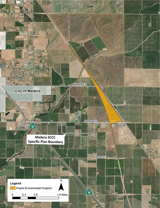
Madera Station Relocation Project                                             Biological Resources Technical Memorandum
San Joaquin Joint Powers Authority

                                                        Tables
Table 2-1          Preliminary Project Capital Cost Estimates.................................................... 14

Table 2.6-1        Estimated Project Ridership .......................................................................... 15

                                         Attachment B Tables
Table 1            Special Status Plant Species Known two or with Potential
                   to Occur on the Project Footprint ................................................................... 51

Table 2            Special Status Wildlife Known to or with Potential to Occur
                   in the Vicinity to Occur on the Project Footprint ............................................. 56

January 2021                                                                                                       P a g e | iii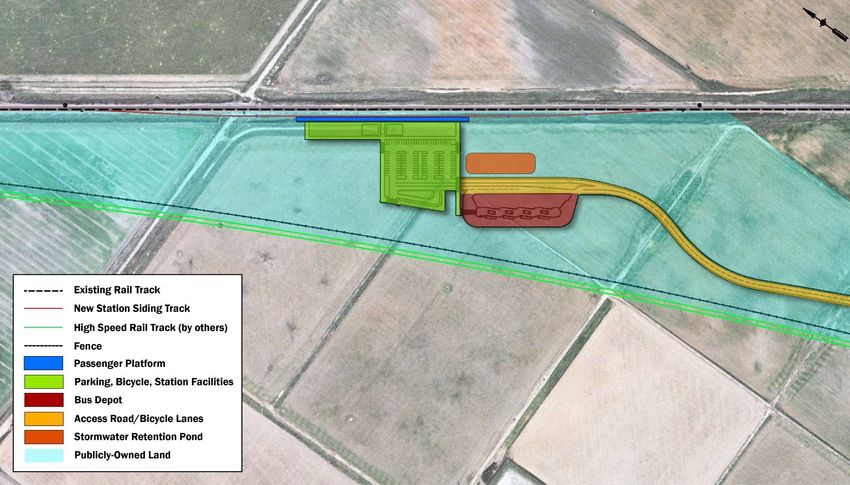
Madera Station Relocation Project                                  Biological Resources Technical Memorandum
San Joaquin Joint Powers Authority

1.                       INTRODUCTION

The purpose of this memorandum is to document research conducted in relation to the Madera Station
Relocation Project (Project) site, to determine if there are potential special-status species and other
sensitive and protected habitats or plant communities on or adjacent to the site that could be affected by
activities related to project construction. This technical information is provided for review under the
California Environmental Quality Act (CEQA), the California Endangered Species Act (CESA), the federal
Endangered Species Act (ESA), and other pertinent regulations. The findings and conclusions summarized in
this memorandum are based on desktop research of publicly-available databases and information, and past
surveys and environmental studies performed in the area.

2.               PROJECT DESCRIPTION

The Project consists of various project elements that can be separated into two phases, based on their
purpose and timing of construction and implementation. The first phase, or the “Phase 1 – San Joaquins
Relocated Station” (Phase 1), consists of elements related to the Relocated Madera San Joaquins Station
(Relocated Station) from Madera Acres to the location described in the vicinity of Avenue 12

The existing Madera San Joaquins Station would no longer be used for San Joaquins operations following
commencement of San Joaquins service at the Relocated Station. The second phase of the Project, or the
“Phase 2 – HSR Interim Operating Segment Station” (Phase 2), consists of high-speed rail improvements at
the Relocated Station to allow for future HSR service along California’s future Merced to Bakersfield High-
Speed Rail Interim Operating Segment, to access the Relocated Station (Figures 2-4, and 2-5). This HSR
services is anticipated to be operated by the SJJPA.

For both Phase 1 and 2, the design, construction, and operation of the Project’s rail components would
comply with applicable standards from the Federal Railroad Administration (FRA) and/or California Public
Utilities Commission (CPUC). Similarly, design, construction, and operation of site access improvements,
including new roadways or modifications to existing roadways, would adhere to applicable standards such
as the California Manual on Uniform Traffic Control Devices (MUTCD) and local design guidelines and
specifications. Design approval for specific project components would be sought from the appropriate
agencies as part of detailed design and subsequent stages of the Project.

2.1              Project Environmental Footprint

The Project Environmental Footprint (Project Footprint) is shown in Figure 2-1. In the north-south direction,
the Project Footprint stretches approximately 3,600 feet north of Cottonwood Creek and approximately
150 feet south of Avenue 11 to accommodate trackwork associated with the Project. The Project Footprint
also widens between Avenue 13 and Avenue 11 to accommodate the Project’s station facilities and access
road.

January 2021                                                                                      P a g e |1
Madera Station Relocation Project                             Biological Resources Technical Memorandum
San Joaquin Joint Powers Authority

                         Figure 2-1. Proposed Project Environmental Footprint

January 2021                                                                                P a g e |2
Madera Station Relocation Project                                  Biological Resources Technical Memorandum
San Joaquin Joint Powers Authority

2.2              Phase 1 – San Joaquins Relocated Station

2.2.1            Platform

As described below, the Relocated Station for Phase 1would consist of a single side-loaded platform
approximately 600 feet in length. The platform may include a canopy or canopies to offer protection from
the elements for waiting passengers. There would also be fare machines, information panels, security video
cameras, and lighting in the platform area. In general, the platform area would look similar to the existing
Madera San Joaquins Station. Figures 2-2 and 2-3 show the proposed general layout of the Relocated
Station, including the platform that the San Joaquins would utilize.

2.2.2            Trackwork

In order to access the Relocated Station platform, a new station siding track extending from the existing
BNSF mainline single-track would be constructed. The entire length of the new station siding track, from
the turnout locations at the north and south would be approximately 2,330 feet. The turnouts would be
design for 50 mph. The new track would have a ballast base similar to the existing ballasted tracks on the
BNSF Corridor.

2.2.3            Bus Depot

A bus depot would be constructed southeast of the proposed platform. The bus depot would be accessible
via the access road. As part of the Phase 1, the entire footprint of the bus depot would be established, with
space reserved for up to eight bus bays. However, only four of the eight bus bays would be constructed.

2.2.4            Parking

A surface parking lot would be constructed adjacent to and west of the Relocated Station platform, with 98
parking spaces that would be equipped with lighting and security video cameras. No parking structures are
proposed. The parking lot would be accessed through via an access road connecting from Avenue 12.
Parking would include disability parking. Additionally, a pick-up/drop off facility with a turnaround loop
would be located within the westernmost area of the parking lot.

2.2.5            Access Road

A new two-lane access road would be constructed to provide access to the Relocated Station facilities from
Avenue 12. The access road would primarily run adjacent to the CAHSR Project right-of-way and would
connect to the new elevated section of Avenue 12 via a ramp structure on the north side of new grade-
separated section of Avenue 12. Both the new elevated section of Avenue 12 and the ramp are being
constructed as part of the CAHSR Project (Figure 2-2). No sidewalks or bike lanes would be included in the
access road as part of Phase 1. The Phase 1 access road would include Class II bicycle lanes.

January 2021                                                                                       P a g e |3

Madera Station Relocation Project                                                                Biological Resources Technical Memorandum
San Joaquin Joint Powers Authority

                            Figure 2-2 Proposed Design for Phase 1 – San Joaquins Relocated Station (Overview)

January 2021                                                                                                                   P a g e |4
Madera Station Relocation Project                        Draft Initial Study/Mitigated Negative Declaration
San Joaquin Joint Powers Authority

2.2.6           Roadway Network

The access road would also connect to a section of road located in an underpass through the grade-
separated Avenue 12 being constructed as part of the CAHSR Project. This underpass would provide a
connection to the at-grade Avenue 12 frontage road on the south side of the new elevated section of
Avenue 12. The Avenue 12 frontage road is not a Project element and is section of the same roadway
that is the current Avenue 12 and would provide access to properties located immediately south of
Avenue 12 and in between the CAHSR Project corridor to the west and the existing BNSF corridor to the
east.

2.2.7           Buildings and Structures

A small building or buildings would be constructed to house restrooms and cleaning supplies/equipment
for station maintenance, which would be located immediately west the station platform. The building(s)
would be one-story (approximately 12 feet) tall. In addition, lighting posts with light-emitting diode
(LED) light fixtures would be installed. Various types of signage would be also installed. Bicycle storage
facilities would also be included at the station.

A stormwater drainage system would be constructed to provide drainage for stormwater from the
access road, parking lot, and other station facilities. The drainage system would lead to a stormwater
retention pond located immediately south of Phase 1 parking structure. The stormwater retention pond
would be designed to accommodate additional stormwater anticipated from the expanded station
facilities and access road associated with Phase 2.

An onsite Wastewater Treatment System (OWTS) would be constructed to treat wastewater from the
planned station restroom. It is assumed that the Project would not be hooked up to the sewer system.

2.2.8           Trains

Trainsets utilized by the San Joaquins and serving the new Relocated Station during Phase 1 would be
FRA-complaint diesel-based rolling stock, the same or similar to trainset currently operated for the San
Joaquins today. Most of the trainsets utilized for the San Joaquins Service will be hauled by Tier 4
locomotives at the time of service commencement (estimated for 2024).

2.3             Phase 2 – HSR Interim Operating Segment Station

2.3.1           Platform

As part of Phase 2, a new single side-loaded platform would be constructed parallel to the CAHSR
Project trackwork now under construction to the west and immediately adjacent to a new station siding
track (see below for more details). The platform would be approximately 1,000 feet in length and may
include canopies to protect passengers from the elements. The height of the platform would be
designed to accommodate trainsets to be selected for the HSR system. The platform would also be

January 2021                                                                                       Page | 5
Madera Station Relocation Project                       Draft Initial Study/Mitigated Negative Declaration
San Joaquin Joint Powers Authority

located approximately 365 feet west of the northerly edge of the platform built as part of Phase 1
(Figures 2-4, 2-5, and 2-6).

January 2021                                                                                      Page | 6
Madera Station Relocation Project                                                                Biological Resources Technical Memorandum
San Joaquin Joint Powers Authority

                       Figure 2-3. Proposed Design for the Phase 1 – San Joaquins Relocated Station (Detailed View)

January 2021                                                                                                                   P a g e |7
Madera Station Relocation Project Biological Resources Technical Memorandum
San Joaquin Joint Powers Authority
Figure 2-4. Proposed Design for the Project Phase 2 – HSR Interim Operating Segment Station (Overview)
January 2021 P a g e |8Madera Station Relocation Project Biological Resources Technical Memorandum
San Joaquin Joint Powers Authority
Figure 2-5. Proposed Design for the Project Phase 2 – HSR Interim Operating Segment Station (Detailed View)
January 2021 P a g e |9Madera Station Relocation Project Biological Resources Technical Memorandum
San Joaquin Joint Powers Authority
Figure 2-6. Proposed Design for the Project Phase 2 – HSR Interim Operating Segment Station (Station Close-In View)
January 2021 P a g e | 10Madera Station Relocation Project Biological Resources Technical Memorandum San Joaquin Joint Powers Authority 2.3.2 Trackwork and Overhead Contact System In order to provide access to the HSR platform, a new station siding track would be constructed to the east of the two-track mainline being constructed for the CAHSR Project. The entire length of the new station siding track, from the turnout locations at the north and south would be approximately 14,600 feet in length. The turnouts would be design for 110 mph. In addition, new crossover tracks would be constructed within the CAHSR Project corridor to the north and south of the new station siding track to allow southbound HSR trains to access the HSR platform at the Relocated Station. When including the north and south crossover tracks within the CAHSR Project right-of-way, this would extend the length of the trackwork associated with the Project to a total length of 17,300 feet. The northern crossover track would extend approximately 3,600 feet north of Cottonwood Creek. The southern crossover track would extend approximately 150 feet south of Avenue 11. The station siding track would include a new rail bridge over Cottonwood Creek. The proposed bridge would be a single track, 5 span continuous cast-in-place, reinforced concrete slab type structure, matching the span arrangement and hydraulic conveyance capacity of the existing double-track bridge constructed as part of the CAHSR Project. The bridge would be 24 feet in width, 250 feet in length, and would be supported on 2 – 3’ diameter cast-in-drilled-hole (CIDH) piles at each abutment and bent; each pile would be approximately 40 to 50 feet deep. The CIDH supported abutments would extend approximately 8 to 10 feet below the existing ground surface. Two storage tracks for HSR trains would be constructed as part of Phase 2 of the Project. One storage track would extend from the station siding track to the north approximately 1,900 feet. A second storage track would extend south from station siding track approximately 1,900 feet (Figures 2-4, 2-5, and 2-6). In association with the Phase 2 trackwork, an overhead contact system (OCS) would be constructed along entire length of the station siding track and storage tracks to provide electrical power to electrified trainsets. The OCS would consist of poles at intervals matching the OCS poles being constructed as part of the CAHSR Project. These OCS poles are expected to be approximately 30 feet tall and would have foundations approximately 6 to10 feet deep. To provide power to the OCS system, a small Transmission Power Substation (TPSS) may be needed, though there is a possibility electrical power could be drawn from the OCS planned to be constructed in association with the adjacent mainline CHSRA Project tracks. If a TPSS is required, it would be located in an area in the vicinity of the north end of the HSR platform. 2.3.3 Bus Depot A bus depot would be constructed just south of the access road as it approaches the Station parking lot. As part of Phase 1, the west side of the bus depot footprint would be built, including four bus bays. In Phase 2, four additional bus bays would be constructed such that a total of eight bus bays are operational. January 2021 P a g e | 11
Madera Station Relocation Project                                  Biological Resources Technical Memorandum
San Joaquin Joint Powers Authority

2.3.4            Parking

The parking lot constructed as part of Phase 1 would be expanded by 179 additional spaces, for a total of
277 parking spaces in Phase 2. The additional parking would expand the size of surface lot; no parking
structures are proposed. The parking area would be accessed through one road connecting from Avenue
12. Parking would include disability parking. The pick-up/drop-off facility already provided in Phase 1 would
be expanded with an additional 530 linear feet of curbside access divided between two additional lanes.

2.3.5            Access Road

In order to accommodate the trackwork required to reach the HSR platform, a portion of the access road
constructed during Phase 1 would be reconfigured and relocated. The reconfigured portion of the access
road would shift to the east and rise to meet the elevated portion of the Avenue 12 grade separation where
a new signalized intersection would be created (Figure 2-5). The reconfigured portion of the access road
would be a four-lane road. Furthermore, the remaining portion of the Phase 1 access road that extends
north to the station, would be widened from the two-lanes to a four-lane road. A sidewalk and Class II
bicycle lanes would be also added to the widened access road during Phase 2.

In addition, a 2-lane auxiliary segment of access road would be built around the southern and eastern sides
of the proposed stormwater retaining pond to provide an additional access point into the expanded parking
lot.

2.3.6            Road Network

The new station siding track associated with Phase 2 of the Project would be constructed in the same space
occupied by the automobile underpass currently under construction as part of the CAHSR Project. This
would result in removal of the roadway in that space and severing the original automobile access to the
Avenue 12 frontage road on the south of elevated Avenue 12. To address this, a new underpass would be
constructed for automobiles slightly to the east (Figure 2-5). This new underpass would connect to the at-
grade frontage road along the south side of Avenue 12. Construction of the new underpass in Phase 2 of
the Project would require penetrating the retained fill of the Avenue 12 grade separation structure built as
part of the CAHSR Project and constructing necessary support structures for the elevated Avenue 12.

2.3.7            Buildings and Structures

A building or buildings would be constructed in close proximity to the east of the HSR platform to provide
space for station staffing support facilities, restrooms and cleaning supplies/equipment for station
maintenance. The building(s) would be one-story (approximately 12 feet) tall. In addition, lighting posts and
signage would be installed. Additional stormwater drainage facilities would be needed for the expanded
station facilities and expanded roadway, but no additional work would be needed on the stormwater
drainage basin constructed in Phase 1. Additional wastewater facilities would be need for additional
bathroom planned near the CAHSR platform. Bicycle storage facilities would also be included at the station.

January 2021                                                                                     P a g e | 12
Madera Station Relocation Project Biological Resources Technical Memorandum
San Joaquin Joint Powers Authority
2.3.8 Trains
CAHSR trainsets would likely consist of lightweight electric multiple units (EMU) trainsets. However, no final
decision has been made on rolling stock to-date. This Project has no influence on the selection of CAHSR
rolling stock.
2.4 Construction Period
The construction of the proposed Project would be done in phases. Phase 1 would include all Project
elements required to allow for the operations of the San Joaquins service at the Relocated Station.
Construction of Phase 1 of the Project is anticipated to last 12 months. Construction of Phase 1 is
anticipated to commence in 2023 and be completed in 2024. The construction schedule for Phase 1 is
being coordinated with the construction of the CAHSR Project. CHSRA has indicated they will need to utilize
the site of the Relocated Station (currently owned by the CHSRA) as a staging area for the CAHSR project.
Given this, the schedule for Phase 1 would be delayed from the original anticipated commencement date
by approximately 1.5 years.
Phase 2 would include all Project elements required to allow for the operations of HSR trains at the
Relocated Station. Construction of Phase 2 of the Project is anticipated to last approximately 2 years.
Assuming funding is secured, construction for Phase 2 is anticipated to commence in 2026 and be
completed in 2028.
Access to construction sites would occur via a temporary access road within the Project Footprint
connecting with the proposed access road segments during Phase 1 and Phase 2. There could be limited,
temporary road closures, and road construction that could potentially cause increased traffic congestion in
areas where emergency vehicles operate. These improvements could potentially disrupt traffic during
construction activities and interfere with emergency response times.
Contractors would use staging areas within the Project Footprint and standard industry equipment such as
excavators, pavers, and dump and concrete trucks to support the construction of the Project. For the
construction of the new bridge over Cottonwood Creek, pile-driving equipment would be utilized.
Best Management Practices (BMPs) that would be implemented as part of the Project include:
Use of fabric-covered screening fences to minimize public views of the construction activities,
equipment, and stockpiles.
Positioning of light direction and shielding, which would minimize lighting spillover.
Measures found in Caltrans’ Construction Site Field Manual and Troubleshooting Guide (Caltrans
2003a), and the Construction Site BMP Manual (Caltrans 2003b) to reduce impacts to soil erosion
Standard construction practices such as Best Available Technology Economically Feasible (BATs),
Best Conventional Pollutant Control Technology (BCTs) would help reduce potential impacts related
to storm water drainage systems
January 2021 P a g e | 13Madera Station Relocation Project Biological Resources Technical Memorandum
San Joaquin Joint Powers Authority
2.5 Preliminary Project Capital Cost Estimates
Preliminary cost estimates of all Project elements – including trackwork, platforms, station facilities, power
systems, drainage, bus depot, access road, and parking lots – were conducted for both Phases 1 and 2.
Table 2-1 below provides the estimated cost for each phase, as well as a total for both phases. For more
information on the preliminary capital cost estimates, refer to Appendix F (Preliminary Project Capital Cost
Estimates).
Table 2-1. Preliminary Project Capital Cost Estimates
Phase 1 Phase 2 Total (Both Phases)
$24.9 Million $105.0 Million $129.9 Million
Source: AECOM 2020.
For more information on the preliminary capital cost estimates, refer to Appendix F (Preliminary Project
Capital Cost Estimates).
2.6 Operations
Phase 1 of the Project presumes up to eight (8) San Joaquins roundtrip a day when the Relocated Station
opens for service (anticipated in 2024). Phase 2 presumes up to eighteen (18) HSR service roundtrips a day
(anticipated to commence in 2029). Once HSR service commences to the Relocated Station during Phase 2,
San Joaquins trains would no longer serve the Relocated Station and would instead terminate at a new
downtown multi-modal hub station in Merced, where they would connect to HSR trains, leaving only 18
HSR daily roundtrips serving Relocated Station.
Once the San Joaquins terminate in Merced, it is possible that there could be local/regional passenger rail
service in the future that utilizes the slots that the San Joaquins would no longer utilize. However, this
would have to be separate project and is not in the scope of this Project.
Ridership analysis was conducted for Phase 1 and Phase 2 for the years 2025 and 2029 respectively, which
reflect estimated ridership for the operational plans at the Relocated Station described above, as well as for
a No-Build condition, where the Existing Station is not relocated. Ridership was assessed by estimating
passenger “ons and offs” (or “boardings and alightings”). In this approach, each person is counted twice
(once for getting on at a station and once for getting off at a station). Therefore, the number of actual
passengers would be 50% of the numbers shown above. Estimating ons/offs is useful to assess usage of the
station facilities, etc.
The estimated ridership is summarized in Table 2.6-1 below.
January 2021 P a g e | 14Madera Station Relocation Project Biological Resources Technical Memorandum
San Joaquin Joint Powers Authority
Table 2.6-1. Estimated Project Ridership
No Build1 Phase 12 Project Phase 23
2025 2025 2029
(San Joaquins) (San Joaquins) (High-Speed Rail Service)
40,2001 103,1002 210,6003
(passenger ons/offs) (passenger ons/offs) (passenger ons/offs)
Notes:
1
Assumes eight (8) San Joauquins roundtrips serving the Existing Station.
2
Assumes eight (8) San Joauquins roundtrips serving the Relocated Station.
3
Assumes eighteen (18) high-speed rail roundtrips serving the Relocated Station.
For more information on the ridership estimates, refer to Appendix G (Ridership, Vehicle Miles Traveled,
and Parking Estimates).
2.7 Required Permits
The Project is subject to CEQA, and the SJJPA is the lead agency for the Project. As such, SJJPA must oversee
environmental review of the Project under CEQA, prior to approving the Project. SJJPA recognizes the need
for a close relationship with Madera County (County) and the nearby City of Madera (City) and wishes to
pursue the planning and environmental review of the Project in such a way that SJJPA, the County and the
City can agree that the Project would be of overall community benefit and that all reasonable efforts to
avoid significant environmental effects have been made. Towards this end, SJJPA would comply with
regulations regarding site planning and construction, including such ordinances as the County noise
regulations and provisions of the County’s stormwater sewer system discharge permit.
The Project requires the following approvals and permits from agencies including:
County of Madera Public Works Department of Public Work’s Grading and Erosion Control Permit.
County of Madera Public Works Department of Public Work’s Encroachment Permit Application
Central Valley Regional Water Quality Control Board’s NPDES Construction General Permit Order
2009-0009-DWQ (as amended by 2010-0014-DWQ and 2012-0006-DWQ).
Central Valley Regional Water Quality Control Board, Clean Water Act (CWA) Section 401
Permit/Waste Discharge Requirements.
A consultation with U.S. Fish and Wildlife Service (USFWS) and the California Department of Fish
and Wildlife (CDFW) would be conducted if special status plant specifies cannot be protected and
an Incidental Take Permit (ITP) would be attained.
CDFW Section 1600 Streambed Alteration Agreement.
Central Valley Flood Protection Board (CVFPB) Encroachment Permit.
Army Corps of Engineering Clean Water Act (CWA) Section 404 Permit.
The California High-Speed Rail Authority (CHSRA) would need to approve connection into their
track infrastructure.
2.8 Public Outreach
The SJJPA has engaged local stakeholders and agencies, as well as the general public in the Project’s
development since before the environmental process began. SJJPA has conducted ongoing coordination
January 2021 P a g e | 15Madera Station Relocation Project Biological Resources Technical Memorandum San Joaquin Joint Powers Authority with the Madera County, Madera CTC, and the City of Madera since late 2016. The Madera CTC and Madera County sent letters of support for the Madera Station Relocation’s TIRCP application. In 2018, SJJPA prepared and made available to the public a Madera Relocation Station Planning document that discussed the history and best sites for relocating the existing Madera Station. This document was updated in Spring of 2020 and made public. Early on in the environmental process, SJJPA decided to include a robust public outreach component, even though CEQA does not require a substantial outreach effort for an IS/MND (relative to an Environmental Impact Report). An extensive stakeholder and public outreach process was undertaken to educate the public about the Project. Numerous materials were developed that include various information about the Project, including a Project factsheet. Additionally, a dedicated Project webpage was created (housed within the SJJPA website) that not only provided information about the Project but contained a tool to allow members of the public to sign-up to the Project stakeholder list. In addition to providing general information about the Project, in-person public open houses were conceived at the onset of the Project’s environmental process to further inform the public. However, due to COVID-19 and State and local restrictions on gatherings, and for the safety of the public, it was decided that webinars would be held instead of physical public open houses. Three webinars (two in English and one in Spanish) were held on May 14, 2020. Several methods were utilized to promote the public webinars. E-mail notifications (e-blasts) were conducted to the extensive list of stakeholders assembled for the Project. Additionally, flyers, social media posts, and newspaper advertisements (both print and digital) were disseminated to inform the public about public webinars. Additionally, agencies and key stakeholders within Madera County were leveraged to further the reach of e-blasts, flyers and social media posts. The format of all three webinars consisted of a 20-minute PowerPoint presentation on the Project history, the Project description, an overview of the environmental process, and a review of the proposed schedule for the Project. The presentation portion of the webinars were followed by a question and answer session. Approximately 20 people joined for all three meetings. The email notifications (e-blasts), information sheets (English and Spanish), PowerPoint presentations (English and Spanish), and Project website screenshot are presented in Appendix H (Public Outreach). A second outreach effort will be made once the Draft IS/MND is published. The Draft IS/MND was released to the public on October 14, 2020. A Notice of Intent to Adopt an IS/MND (NOI) was published in the physical and digital versions of the Madera Herald Newspaper published on October 14, 2020. The NOI was also filed with the Madera County Clerk’s Office and delivered to the California State Clearinghouse on October 14, 2020. The Draft IS/MND was made available for viewing and downloading on the Project’s webpage: https://sjjpa.com/madera-station-relocation-project. The NOI also provided a project email to which comments could be sent: MaderaStationComments@sjjpa.com. Email e- blasts were used to notify all stakeholders from the previous outreach effort in addition to any new people that signed up to be notified through the Project website. January 2021 P a g e | 16
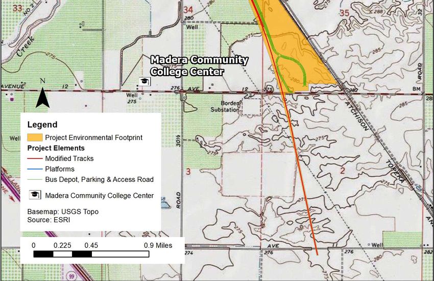
Madera Station Relocation Project                                   Biological Resources Technical Memorandum
San Joaquin Joint Powers Authority

During the public review period of the Draft IS/MND (October 14 through November 16), two public
meetings via webinars were held on Thursday, November 5, 2020, at 10:30 a.m. and at 6:00 p.m. A total of
14 people attended both webinars, and we received eight distinct comments during both webinars, which
are documented and responded to in Appendix I. Noticing for the November 5, 2020 webinars was similar
to the noticing for the May webinars as described above. The content of both November 5 webinars was
exactly the same and included information on the conclusions of the Draft IS/MND, including impacts and
mitigations. All outreach materials in support of the Draft IS/MND and the public webinars on November 5,
2020 are provided in Appendix H.

In addition to this outreach, Dan Leavitt of the SJJPA had further meetings with Madera City Manager on
November 5 and November 13, 2020 as well as made a presentation to the Madera City Council on
November 18, 2020.

Comments were received by email, webpage, during the webinars, and posted to the CEQAnet page for this
project. All comments were responded to in Appendix I.

3.               METHODS

A qualified AECOM biologist searched the several public databases for records of special-status plants and
wildlife documented on or around the Project Footprint. The California Native Plant Society (CNPS 2020a)
and the California Natural Diversity Database (CNDDB) (CDFW 2020) were searched for species and
sensitive natural communities documented within the Gregg and eight surrounding United States
Geological Survey (USGS) 7.5-minute quadrangles; the U.S. Fish and Wildlife Service (USFWS) Information
for Planning and Conservation (IPaC) project planning tool (USFWS 2020) was used to generate an IPaC
resource list, which includes federally-listed species with potential to occur in the region along with their
known or expected range; and the eBird database, which is managed by the Cornell Lab of Ornithology
(eBird 2020).
In addition to these resources, this analysis included a review of the Biology Resources and Wetlands
section in the California High-Speed Train: Merced to Fresno Section Draft Project Environmental Impact
Report/Environmental Impact Statement (CAHSR EIR/EIS) (CAHSRA 2011), which included reconnaissance-
level field surveys that determined presence or absence of biological resources and documented the
location of biological resources through habitat characterization and mapping.
The searches and analysis resulted in a list of special-status plant and wildlife species that have been
previously documented and/or could potentially to occur on or in the vicinity of the proposed Project
Environmental Footprint (Project Footprint). The special-status species list is summarized in Tables 1 and
Table 2 (Attachment B) and also includes suitable habitat typically associated with each species; critical
seasonal periods associated with the species’ natural history; potential for the species to occur on or near
the Project Footprint; and general comments. A map showing the documented CNDDB occurrences within a
3-mile radius of the Project Footprint is presented in Attachment A, Figure-3.
Fieldwork was conducted on December 16, 2020 by Charles Battaglia. Permit to enter was granted for two
parcels owned by the CAHSRA (APNs 047-070-027 and 047-070-022). No other permit to enter was granted
in the Project footprint. As such, the fieldwork was limited to observing seasonal wetland (SW) -4 as

January 2021                                                                                       P a g e | 17
Madera Station Relocation Project                                   Biological Resources Technical Memorandum
San Joaquin Joint Powers Authority

described in the environmental setting below. The fieldwork involved visual characterization of the areas
that have the potential for having sensitive habitat for species of concern. No sampling was done.

4.               ENVIRONMENTAL SETTING

Madera County is located within the California Floristic Province, which is characterized by a Mediterranean
climate with cool, wet winters and hot, dry summers. The elevation of the Project Footprint ranges from
approximately 280 to 290 feet above mean sea level. Soils consist of 12 types of sandy loam, two of which
are over hardpan; one sandy soil over hardpan, and one clay soil; nearly all the soils are from toe slope
and/or alluvium origins; and they vary from 0 to 8 percent slopes.
Nearly all the land cover within the Project Footprint is comprised of agriculture that includes orchards,
grapes, and grain fields. Some of the grain fields are periodically uncultivated and plowed and/or in a fallow
state, as are orchard and grape fields that remove old stock and replant the fields. The only uncultivated
areas of land are narrow bands of annual grassland and ruderal vegetation that parallel the west side of the
existing San Joaquins BNSF Corridor track, between the track and the dirt roads that border the agricultural
fields. These areas are highly disturbed from being immediately adjacent to the agriculture operations, but
six small linear-to-oblong depressions, mapped as seasonal wetlands, are located parallel to the toe of the
railroad embankment and have potential to provide potentially suitable habitat for special-status vernal
pool species. One other wetland feature at the northern end of the Project Footprint is located slightly
farther west from the railroad tracks in the edge of a grain field and is mapped as a vernal pool due to
recent CNDDB records of a special-status vernal pool plant species, hairy Orcutt grass (Orcuttia Pilosa) in
the pool, and because this field and others to the north and east contain numerous vernal pools and
documented special-status species. There is also an ephemeral or intermittent stream (Cottonwood Creek)
located approximately 0.5 mile north of Avenue 13. The stream crosses under the San Joaquins BNSF
Corridor track and a newly constructed crossing/span that will support the CAHSR track, both are elevated
over the creek. Within and immediately upstream and downstream the Project Footprint, Cottonwood
Creek is dry most of the year and only flows periodically during wet season. The CAHSR EIR/EIS refers to
Cottonwood Creek as an intermittent drainage, but the creek is mapped as an ephemeral drainage by USGS
(USGS 2018). Due to the dry conditions in this reach of the channel, there is a lack of well-established
riparian vegetation. There are, however, occasional Goodding’s willow (Salix gooddingii) and Fremont
cottonwood (Populus fremontii) trees north and south of the crossings that provide nesting habitat for
birds. The creek is not expected to provide suitable habitat for special-status fish or plant species, but
multiple Swainson’s hawk (Buteo swainsoni) nests are documented in the CNDDB in 2016 and 2017
downstream of the track crossings. Surrounding land use is primarily the same kind of agriculture described
within the Project Footprint, but there are large uncultivated areas of vernal pool habitat on the east side of
the San Joaquins BNSF Corridor track north of Avenue 13, another smaller triangular-shaped area with
vernal pools immediately south of Avenue 13, and the field partially within and mostly adjacent and north
of the Project Footprint is cultivated with grain crops but also contains vernal pool habitat. A map of the of
the land cover and habitat types is presented in Attachment A, Figure 4.

January 2021                                                                                       P a g e | 18
Madera Station Relocation Project Biological Resources Technical Memorandum
San Joaquin Joint Powers Authority
5. SENSITIVE BIOLOGICAL RESOURCES
Sensitive biological resources addressed in this section include those that are afforded consideration or
protection under the California Environmental Quality Act (CEQA), California Fish and Game Code,
California Endangered Species Act (CESA), Federal Endangered Species Act (ESA), Clean Water Act (CWA),
and the Porter-Cologne Water Quality Control Act (Porter-Cologne Act).
6. SPECIAL-STATUS SPECIES
Special-status species include plants and animals in the following categories:
Species officially listed by the state or Federal government as endangered, threatened, or rare;
Candidates for state or Federal listing as endangered or threatened;
Taxa (i.e., taxonomic categories or groups) that meet the criteria for listing, even if not
currently included on any list, as described in California Code of Regulations (CCR) Section
15380 of the State CEQA Guidelines;
Species identified by the California Department of Fish and Wildlife (CDFW) as species of special
concern;
Species listed as Fully Protected under the California Fish and Game Code;
Species afforded protection under local or regional planning documents; and
Taxa considered by CDFW to be “rare, threatened, or endangered in California” and assigned a
California Rare Plant Rank (CRPR). The CDFW system includes six rarity and endangerment
ranks for categorizing plant species of concern, which are summarized as follows:
CRPR 1A – Plants presumed to be extinct in California;
CRPR 1B – Plants that are rare, threatened, or endangered in California and
elsewhere;
CRPR 2A – Plants presumed to be extinct in California, but more common
elsewhere;
CRPR 2B – Plants that are rare, threatened, or endangered in California, but more
common elsewhere;
CRPR 3 – Plants about which more information is needed (a review list); and
CRPR 4 – Plants of limited distribution (a watch list).
7. SENSITIVE NATURAL COMMUNITIES AND HABITATS
Sensitive habitats include those that are of special concern to resource agencies or are afforded specific
consideration through CEQA Guidelines, Section 1602 of the California Fish and Game Code, Section 404 of
the CWA, and the State’s Porter-Cologne Act, as noted in the Regulatory Setting section below. Sensitive
natural communities may be of special concern to these agencies and conservation organizations for a
variety of reasons, including their locally or regionally declining status, or because they provide important
habitat to common and special-status species. Sensitive habitats often provide other important ecological
functions, such as enhancing flood and erosion control and maintaining water quality.
CDFW maintains a list of California Sensitive Natural Communities that are native to California (CDFW
2019). Within the current list, CDFW identifies special-status (or sensitive) natural communities, which they
define as communities that are of limited distribution statewide or within a county or region and often
vulnerable to environmental effects of projects. These communities may or may not contain special-status
species or their habitat.
January 2021 P a g e | 19Madera Station Relocation Project Biological Resources Technical Memorandum
San Joaquin Joint Powers Authority
8. REGULATORY SETTING
Many federal, state and local laws and regulations protect biological resources in California. The following
are applicable to the Project:
Federal Clean Water Act (Section 404 and 401) – protection of wetlands and other waters of
the United States
State Porter Cologne Act – protects waters of the State
Federal and State Endangered Species Acts (ESA and CESA) – protection of species federally or
state listed or proposed for listing
Federal Migratory Bird Treaty Act (MBTA) – protects birds and their nests
Fish and Game Code Section 3503 – protects active nest or eggs of any bird
Fish and Game Code Section 1600 – requires permit to alter bed and bank of streams and lakes
Madera County General Plan – contains policies to protect species and wetlands
9. THRESHOLDS FOR BIOLOGICAL RESOURCES
To determine whether a proposed Project would have a significant impact on biological resources,
Appendix G to the CEQA Guidelines requires consideration of whether a project would result in:
A substantial adverse effect, either directly or through habitat modifications, on any species
identified as a candidate, sensitive, or special-status species in local or regional plans, policies,
or regulations, or by the California Department of Fish and Game or the USFWS;
A substantial adverse effect on any riparian habitat or other sensitive natural community
identified in local or regional plans, policies, or regulations or by the California Department of
Fish and Game or the U.S. Fish and Wildlife Service;
A substantial adverse effect on state or federally protected wetlands (including, but not limited
to, marsh, vernal pool, coastal, etc.) through direct removal, filling, hydrological interruption, or
other means;
Substantial interference with the movement of any native resident or migratory fish or wildlife
species or with established native resident or migratory wildlife corridors, or impede the use of
native wildlife nursery sites;
A conflict with any local policies or ordinances protecting biological resources, such as a tree
preservation policy or ordinance; and
A conflict with the provisions of an adopted Habitat Conservation Plan, Natural Community
Conservation Plan, or other approved local, regional, or state habitat conservation plan.
10. POTENTIAL IMPACTS
10.1 Potential Impacts to Special-Status Species
The following special-status species were determined to have potential to occur within the Project
Footprint and be subjected to disturbance by construction and/or operational impacts.
January 2021 P a g e | 20Madera Station Relocation Project Biological Resources Technical Memorandum
San Joaquin Joint Powers Authority
10.1.1 Special-Status Plants: Hairy Orcutt grass (Orcuttia Pilosa), San Joaquin Valley Orcutt grass
(Orcuttia inaequalis), succulent owl's-clover (Castilleja campestris var. succulenta), and spiny-
sepaled button-celery (Eryngium spinosepalum)
There are six small linear-to-oblong depressions mapped as seasonal wetlands (Attachment A, Figure 4)
that are located parallel to the toe of the existing railroad embankment, which have characteristics of
potential habitat for special-status plants. One of these features (SW-4) is located below the footprint of
the new Madera Station and therefore would be filled and degraded from the construction activities.
During the field survey conducted on December 16, 2020 it was noted that the existing SW-4 feature was
disturbed and littered with trash at one end, and that it may dry out too early in some years to be suitable
habitat for sensitive species. Although Hairy Orcutt grass, San Joaquin Valley Orcutt grass, succulent owl's-
clover, and spiny-sepaled button-celery are known to inhabit vernal pools that contain specific hydrological
and soil characteristics and conditions, those specific hydrological and soil characteristics are not expected
to occur in these any of these six seasonal wetlands. Therefore, the construction of the Madera Station
would not adversely affect special-status plant species.
The vernal pool feature mapped at the northern end of the Project Footprint could potentially support
hairy Orcutt grass, San Joaquin Valley Orcutt grass, succulent owl's-clover, and spiny-sepaled button-celery.
While this vernal pool feature is within the Project Footprint, it is approximately 10 feet east of the CAHSR
track construction footprint. Construction activities in this vernal pool would result in direct impacts on
these special-status plant species. In addition, alteration of soil conditions in or near the vernal pool by
clearing and grading may result in the loss of native seed banks, or changes to topography and drainage
patterns that could impair the ability of the habitat to support these vernal pool species in the future.
Potential indirect impacts on these special-status plants from nearby construction activities include
deposition of dust from construction activities that may reduce photosynthetic capacity or inhibit
reproduction by coating leaves and reproductive structures. Indirect impacts could also result from the
creation of conditions favorable for the invasion of weedy exotic species that outcompete native species
and prevent the reestablishment of desirable vegetation, including special-status plants. Ground-disturbing
activities have the potential to result in the introduction and spread of noxious weed species of concern to
local agricultural interests and to the California Invasive Plant Council (Cal-IPC 2020). Invasive plant seeds
can be introduced via construction vehicles and personnel, soils used from backfill, and grading and clearing
of vegetated areas. Invasive seeds may also be introduced after construction by off-highway vehicles, or
livestock from newly created access to areas that previously had limited access. The potential direct and
indirect impacts of construction on these special-status plant species, which are regionally rare and of
limited distribution, would be significant.
This potential impact can be reduced to less than significant with implementation of the mitigation
measures listed below. These measures are consistent with the mitigation measures in the California High-
Speed Train: Merced to Fresno Section Draft Project Environmental Impact Report/Environmental Impact
Statement (CAHSRA 2011). The common mitigation MM-BIO-1 through MM-BIO-14 identify avoidance,
minimization, and compensation measures to minimize potential impacts and effects on special-status
species and other sensitive biological resources. Mitigation Measures MM-BIO-1 through MM-BIO-14 have
multiple benefits that avoid, protect, or compensate for project impacts and effects on special status
species and other biological resources and will be applied to all impacts described below as appropriate. To
January 2021 P a g e | 21Madera Station Relocation Project Biological Resources Technical Memorandum San Joaquin Joint Powers Authority refine the mitigation measures presented below, coordination with federal, state, and local agencies (e.g., USFWS, CDFW) would be conducted before construction. In addition, implementation of MM-BIO-15 would reduce construction impacts on hairy Orcutt grass, San Joaquin Valley Orcutt grass, succulent owl's-clover, and spiny-sepaled button-celery to less than significant by protecting special-status plant occurrences in ERAs and environmentally sensitive areas during construction, or by implementing compensatory mitigation to offset impacts. If direct impacts cannot be avoided, compensatory mitigation would be accomplished by purchasing credits at a mitigation bank or by developing and implementing a Special-Status Plant Mitigation Plan. Mitigation for either approach would be at a 1:1 ratio at a minimum and would offset the loss of special-status plants due to construction activities. Future operation of the Madera Station, the San Joaquins and CAHSR trains, and the increased vehicular traffic at the Madera Station is not expected to have effects on special-status plants that differ substantially from existing conditions. Operational impacts of the CAHSR on special-status plant species would therefore be considered less than significant. 10.1.2 California Tiger Salamander (Ambystoma californiense) California tiger salamander was documented at multiple locations within and immediately adjacent to the Project Footprint in 2015, 2016, and 2017. The CNDDB record documents these locations in eight polygons for California tiger salamander, with six along both sides of Avenue 12, from the San Joaquins BNSF Corridor tracks to approximately 0.5 mile west of the tracks, and two approximately 0.25 mile south behind a PG&E substation in a vernal pool. Of the locations along Avenue 12, one was found dead in 2015, one was taken from a burrow excavation in 2016 and relocated, and five adults and one juvenile were displaced by construction from January to May 2017. Since May 2017, construction of the CAHSR required grading of the entire area, thus any previous habitat has been entirely removed and no longer exists. California tiger salamander could potentially occur in SW-4, which is a long, narrow anthropogenic wetland at the toe of the railroad embankment that is located beneath the proposed Madera Station, and in other seasonal wetlands (SW-1 through SW-6) in the Project Footprint (Attachment A, Figure 4). During the field survey conducted on December 16, 2020 it was noted that the existing SW-4 feature was disturbed and littered with trash at one end, and that it may dry out too early in some years to be suitable habitat for sensitive species. Vernal pool habitat with documented breeding California tiger salamander is located approximately 800 feet south of Avenue 12, approximately 0.5 mile south of the most southern seasonal wetlands (SW-1 through SW-3), and approximately 1.1 miles south of the proposed Madera Station and SW-4. Aestivating California tiger salamander could therefore potentially occur in small mammal burrows anywhere within the Project Footprint, but especially uncultivated areas between agriculture fields and the San Joaquin tracks. The vernal pool in the northern portion of the Project Footprint could also potentially provide breeding habitat for California tiger salamander, and outside of the Project Footprint there are considerably larger pools in the same field that are 0.5 mile or less to the northeast. Additional pools are located to the east of the railroad tracks. Aestivating California tiger salamander could therefore potentially occur in small mammal burrows around this vernal pool or across most of the Project Footprint if they migrate between wetlands. January 2021 P a g e | 22
Madera Station Relocation Project                                   Biological Resources Technical Memorandum
San Joaquin Joint Powers Authority

If California tiger salamander is present in the seasonal wetlands, the vernal pool, or in small mammal
burrows in adjacent uplands, direct impacts would include crushing from construction equipment, exposure
to accidental spills, including contaminants or pollutants, changes in micro/local hydrology, and
displacement due to habitat modification. Direct impacts would also include the permanent conversion of
occupied habitat. Indirect impacts may result from grading and stockpiling soils upslope of the pools,
leading to sediment transfer into the water column. Chemical spills from fuel, transmission fluid, lubricating
oil, and motor oil leaks could contaminate the water column, resulting in mortality or reduced reproductive
success of California tiger salamanders. All of the above direct and indirect impacts associated with
construction of Phase 1 of the Project would be significant.
These potential impacts can be reduced to less than significant with implementation of the mitigation
measures MM-BIO-1 through MM-BIO-14 and with implementation of MM-BIO-16 and MM-BIO-17, which
requires a preconstruction survey for California tiger salamander and implementation of compensatory
mitigation if warranted. MM-BIO-16 would reduce construction impacts on California tiger salamander to
less than significant by providing compensatory mitigation for loss of aquatic and/or upland California tiger
salamander habitat at a 1:1 ratio.
Future operation of the Madera Station, the San Joaquins and CAHSR trains, and the increased vehicular
traffic at the Madera Station is not expected to have effects on California tiger salamanders that differ
substantially from existing conditions. Operational impacts of the Madera Station on California tiger
salamander would therefore be considered less than significant.

10.1.3 Western Spadefoot (Spea hammondii)
Western spadefoot is documented in the CNDDB at the same general locations as California tiger
salamander along Avenue 12. The record notes the habitat was on the north side of Avenue 12, associated
with a manmade berm and agricultural dirt road, that four adults were relocated in April and May of 2017,
and that one adult and dozens of larvae were observed from March to April 2018. Several other CNDDB
records from 2019 document western spadefoot breeding in vernal pools approximately 0.3-mile northeast
of the Project Footprint, immediately east of the San Joaquins BNSF Corridor tracks.
The seasonal wetlands (SW-1 through SW-6) and the vernal pool located in the northern end of the Project
Footprint could provide breeding habitat for western spadefoot, and small mammal burrows in nearby
upland habitat in the Project Footprint could provide refugia for aestivating. If western spadefoot is present
in the seasonal wetlands, the vernal pool, or in small mammal burrows in adjacent uplands, the same direct
and indirect impacts described above for California tiger salamander above could occur to western
spadefoot. These impacts would be significant because this species is of limited distribution and
increasingly imperiled in the state and in Madera County (USFWS 2005).
These potential impacts can be reduced to less than significant with implementation of mitigation
measures MM-BIO-1 through MM-BIO-14, MM-BIO-19, and MM-BIO-20. These measures involve
conducting a habitat assessment, implementing avoidance and minimization measures to protect western
spadefoot habitat, and securing compensatory mitigation at an approved mitigation bank at a 1:1 ratio if
the avoidance and minimization measures cannot be implemented. The compensatory mitigation would
reduce impacts to less than significant by offsetting the loss of aquatic and/or upland western spadefoot
habitat.
January 2021                                                                                      P a g e | 23
You can also read