Mapping the reach of a rural Transitions Nurse Program for veterans with geographic information systems
←
→
Page content transcription
If your browser does not render page correctly, please read the page content below
Connelly et al. Implementation Science Communications
https://doi.org/10.1186/s43058-020-00026-4
                                                                      (2020) 1:36
                                                                                                                           Implementation Science
                                                                                                                           Communications

 SHORT REPORT                                                                                                                                      Open Access

Mapping the reach of a rural Transitions
Nurse Program for veterans with
geographic information systems
Brigid Connelly1*, Lexus L. Ujano-De Motta1, Chelsea Leonard1, Ashlea Mayberry1, Lynette Kelley1,
David Gaskin1 and Heather M. Gilmartin1,2

  Abstract
  Purpose: Rural Veterans who receive inpatient care at a Veterans Health Administration (VA) tertiary facility can face
  significant barriers to a safe transition home. The VA rural Transitions Nurse Program (TNP) is a national, intensive
  care coordination quality improvement program for rural Veterans. To communicate the reach of TNP into rural
  communities, we developed geographic information system (GIS) maps. This study evaluated TNP transitions nurse
  and site champion perceptions of GIS as a communication tool for illustrating the reach of TNP into rural
  communities.
  Methods: Using residence information for TNP enrollees, we built GIS maps using ArcGIS Enterprise, a mapping
  and analytics platform. Residential addresses were matched to Rural-Urban Commuting Area geographical
  categories. Transitions nurse and site champion perceptions of the local and national GIS maps were assessed
  through surveys and interviews. The data were analyzed using descriptive and content analytic methods to identify
  themes.
  Results: Transitions nurses and site champions perceived GIS maps as a valuable, easy to understand, acceptable,
  and appropriate communication tool to illustrate the reach of TNP into rural communities. Interviews revealed three
  common themes: a picture is worth a thousand words, the GIS maps are an effective communication tool, and the
  GIS maps revealed surprising and promising information.
  Conclusions: GIS is a useful communication tool to support to illustrate the reach of an intervention. The GIS maps
  engaged transitions nurses and site champions in discussion. The availability of open access software programs and
  publicly available location data will increase access to GIS for researchers and practitioners.
  Keywords: Rural, Veterans, Implementation science, Geographic information systems

* Correspondence: Brigid.connelly@va.gov
1
 Denver/Seattle Center of Innovation for Veteran-Centered and Value Driven
Care, VA Eastern Colorado Healthcare System, 1700 N. Wheeling St, Aurora,
CO 80045, USA
Full list of author information is available at the end of the article

                                       © The Author(s). 2020 Open Access This article is licensed under a Creative Commons Attribution 4.0 International License,
                                       which permits use, sharing, adaptation, distribution and reproduction in any medium or format, as long as you give
                                       appropriate credit to the original author(s) and the source, provide a link to the Creative Commons licence, and indicate if
                                       changes were made. The images or other third party material in this article are included in the article's Creative Commons
                                       licence, unless indicated otherwise in a credit line to the material. If material is not included in the article's Creative Commons
                                       licence and your intended use is not permitted by statutory regulation or exceeds the permitted use, you will need to obtain
                                       permission directly from the copyright holder. To view a copy of this licence, visit http://creativecommons.org/licenses/by/4.0/.
                                       The Creative Commons Public Domain Dedication waiver (http://creativecommons.org/publicdomain/zero/1.0/) applies to the
                                       data made available in this article, unless otherwise stated in a credit line to the data.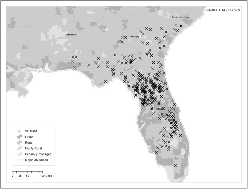
Connelly et al. Implementation Science Communications       (2020) 1:36                                                     Page 2 of 7

                                                                          [5]. Understanding the reach of TNP requires information
 Contributions to the literature
                                                                          on TNP Veterans as well as Veterans eligible for TNP, but
 – Communicating the reach of the Transitions Nurse Program               not enrolled. However, detailed information on Veterans
    (TNP) into rural communities is important for ongoing                 potentially eligible for TNP, but not enrolled, was challen-
                                                                          ging to collect due to the operational focus of the program.
    support and sustainment of program funding but it can be a
                                                                          Sites were permitted to enroll high-risk Veterans that did
    challenge for programs to accurately calculate reach.
                                                                          not meet program criteria, if it was in the best interest of
 – This study evaluated stakeholder perceptions of geographic             that Veteran. Therefore, any calculation of a denominator
    information systems (GIS) as a communication tool for                 of reach was challenging and would not produce a reliable
    illustrating the reach of TNP into rural communities.                 value. A TNP site champion suggested we investigate alter-
 – The study findings contribute to the field by confirming the           native methods to present the reach of TNP into rural
    utility of GIS as a healthcare communication tool, particularly       communities.
    when a barrier to care is geographic location.                           One innovative tool to communicate such information
                                                                          is geographic information systems (GIS), a framework for
                                                                          gathering and analyzing complex information to display as
Background                                                                maps. Within healthcare, GIS have efficiently identified
Nearly 2.7 million Veterans live in rural communities and                 disease patterns, examined relationships between factors
use the Veterans Health Administration (VA) for health-                   such as cost, distance, and access to care, and integrated
care [1]. Access to care for this population is a challenge               large amounts of data for planning and research questions
due to significant geographic distances between VA ter-                   [6]. GIS have guided policy, resource allocation, and con-
tiary hospitals, located in urban settings, and VA clinics                tinuation of research. In the context of public health, GIS
and hospitals, commonly located in rural settings [1, 2].                 maps have been valued for their presentation and commu-
The transition for rural Veterans from hub VA hospitals                   nication properties. GIS maps convert complex, raw data
back home to VA primary care clinics is complicated by                    into usable images that are accessible to a mixed and non-
communication and logistical barriers as well as limited                  technical audience [7]. GIS have been used to assist in
health resources in rural communities [2]. Compared to                    decision-making when location is a key factor of that deci-
the urban Veteran population, rural Veterans experience a                 sion [8]. Within the VA, GIS have helped hospital leader-
higher disease prevalence and lower physical and mental                   ship and staff understand the distribution of Veteran
quality-of-life scores [3]. The VA rural Transitions Nurse                patients, visualize practice patterns, and illustrate the po-
Program (TNP), a nurse-led intensive care coordination                    tential barriers Veterans may face. This helped policy
quality improvement project, was designed to address the                  makers and healthcare staff to prioritize resource alloca-
geographical barriers to care rural Veterans experience                   tion and potentially save Veteran lives [9, 10]. This study
after discharge from urban VA hospitals. A pilot run from                 aimed to evaluate transitions nurse and site champion
2014 to 2016 in Denver demonstrated increased rates of                    perceptions of GIS as a communication tool for illustrat-
follow-up with rural primary care providers, and a trend                  ing the reach of TNP into rural communities.
towards fewer unplanned readmissions for Veterans en-
rolled in TNP [2]. Due to this, TNP was selected for na-                  Methods
tional expansion to 11 VA hospitals by the VA Office of                   Design and population
Rural Health [2, 4]. At each VA hospital, TNP is led by a                 We conducted a mixed methods evaluation of transi-
transitions nurse, who completes the TNP intervention,                    tions nurse and site champion perceptions of the TNP
and a site champion, who serves as a liaison between the                  GIS maps. The 11 transitions nurses that provide care
transitions nurse and VA site leadership.                                 coordination to rural Veterans and the 10 site cham-
   The spread and scale up of TNP across the VA was                       pions that support implementation of TNP at each site
guided by the Reach, Effectiveness, Adoption, Implementa-                 were included. The principal investigator of TNP (HG)
tion, and Maintenance (RE-AIM) framework [5]. The goal                    was a site champion at one site and the interviewer for
of RE-AIM is to encourage implementors and evaluators to                  this project. Transitions nurses and site champions were
pay attention to essential program elements that can                      invited to participate in an online presentation of the
improve the adoption and sustainment of effective,                        2018 TNP Outcomes Report and subsequent interviews
generalizable, evidence-based interventions. Understanding                via email calendar invite. The presentation and inter-
the degree to which TNP reaches those most at risk for                    views were conducted over Skype video conferencing by
poor transitions home was of great interest to VA leader-                 the TNP principal investigator using a semi-structured
ship that supported the program locally. Reach, as defined                interview guide format. The presentations included the
by RE-AIM, refers to the proportion and risk characteristics              reasons and interests in trialing GIS as a communication
of eligible persons who receive or are affected by a program              tool and potential uses of the maps. Transitions nurses
Connelly et al. Implementation Science Communications (2020) 1:36 Page 3 of 7
and site champions were oriented to the maps, and time Creation of TNP GIS maps
was given for a question and answer session prior to the Creation of the GIS maps required ArcGIS mapping soft-
interviews. The interviewer is PhD trained in mixed ware available through the VA Office of Rural Health Geo-
methods and had worked directly with the transitions Spatial Outcomes Division. The data were accessed and
nurses and site champions since 2016. The interviewer, analyzed within the VA Informatics and Computing Infra-
transitions nurses, and site champions were the only structure (VINCI) [14] development workspace using
ones on the call. The design and reporting of the quali- Microsoft SQL (Structured Query Language) Server, Arc-
tative data from this evaluation were performed per the GIS 10.5.x, and File Transfer Protocol. Within the VINCI
Consolidated Criteria for Reporting Qualitative Research workspace, a SQL code was written to pull information for
(COREQ) checklist [11]. In addition to the qualitative Veterans enrolled in TNP between April 2017 and Decem-
data, the Acceptability of Intervention Measures and Ap- ber 2018. This information included TNP Veterans’ ad-
propriateness of Intervention Measures [12] survey was dresses from the VA Corporate Data Warehouse (CDW)
administered and analyzed using descriptive statistics. which were imported into ArcGIS as tabular data. The resi-
dential addresses were geocoded into latitude and longitude
coordinates in order to show their relative spatial locations
Description of interview and survey represented as data points on a map. Data were harmo-
A semi-structured interview guide (Additional file 1: Appen- nized with Rural-Urban Commuting Area (RUCA) codes,
dix 1) was created by a PhD-trained qualitative researcher using state and county Federal Information Processing
(CL) and pilot tested with the Clinical Director of Training Standard (FIPS) codes as a reference table to create a rural-
for TNP (LK). The questions were designed to elicit transi- ity layer. A map layer is a GIS database containing groups
tions nurse and site champion perceptions of the GIS maps, of point, line, or area (polygon) features representing a par-
understand how sites would use the maps, and to solicit ticular class or type of real-world entities such as cus-
suggestions to improve the visual presentation of the GIS tomers, streets, or postal codes. The rurality layer was one
maps. Each interview lasted 30 min and no follow-up inter- of many geographical layers stacked to create a comprehen-
views were conducted. Data saturation was discussed after sive map. Additional layers of contextual data such as state,
each interview between the interviewer and the lead analyst county, census tract boundaries, major roadways, and inter-
(CL). No field notes were taken. The interviews were re- states were downloaded as shapefiles from the US Census
corded using Skype video call and were transcribed verba- Bureau 2018 Topologically Integrated Geographic Encod-
tim. The transcripts were not returned to nurses or ing and Referencing (TIGER) geodatabase [15].
champions for comment or correction. Immediately after A national TNP map and 11 individual site maps were
each presentation and interview, the Acceptability of Inter- created as one-page reports that visually presented catch-
vention Measures and Appropriateness of Intervention ment areas, using color to represent the RUCA-based
Measures [12] survey was emailed to each participant (Add- layers of urban, rural, and highly rural. TNP enrollees with
itional file 1: Appendix 2). The eight-item survey is a vali- missing addresses in CDW were excluded from the study.
dated measure that assesses the acceptability and feasibility
of implementation strategies such as GIS maps. The survey Results
was administered using VA REDCap. The TNP GIS maps communicated the reach of TNP
across both rural and urban areas. Some maps commu-
nicated an even geographical spread of Veteran enrollees
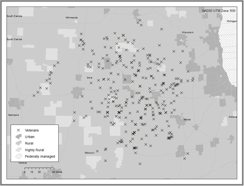
Analysis (Fig. 1), while others showed concentrated clusters of
Transcripts were analyzed using deductive content ana- TNP Veterans (Fig. 2). The TNP population included in
lysis [13] in Microsoft Excel 16.3. A structured the study was 2499 Veterans, with 7 Veterans excluded
categorization matrix were developed to code the data due to missing addresses in CDW. These Veterans were
based on the interview questions. All the interview re- excluded largely due to issues in the VA’s Planning Sys-
sponses were reviewed for content and correspondence tems Support Group (PSSG), including a low-quality
to the following categories: perception of map, plans for geocode “score” and a lag in the publication of the PSSG
using map, and suggestions for map. Only contents that Geocoded Enrollee Files.
fit the matrix of analysis were chosen from the data. The The 11 presentations and interviews were conducted
categories were discussed between the lead analyst and with 11 nurses (10 females, 1 male), 9 physicians (3 fe-
interviewer. Face validity of the categorized results was males, 6 males), and 1 administrator (male). No one re-
established by the Clinical Director of Training for TNP. fused to participate; however, one interview (one nurse,
Quotes were used to enhance the credibility of the re- one physician) was not recorded due to equipment mal-
search findings and demonstrate consistency between function, so data were not captured. Content analysis re-
the data presented and the categories. vealed three main themes related to transitions nurseConnelly et al. Implementation Science Communications (2020) 1:36 Page 4 of 7 Fig. 1 Large geographical spread and site champion perceptions and planned use of the kind of reach we have as a facility. I mean, look at those GIS maps: (1) a picture is worth a thousand words, (2) X’s all the way down in [rural location].” Yet another GIS maps are a good communication tool, and (3) the participant stated, “it’s fun to look at the map and see GIS maps revealed surprising and useful information. the severe isolation.” A picture is worth a thousand words The GIS maps are a good communication tool Most transitions nurses and site champions indicated Transitions nurses and site champions felt the maps that the maps illustrated that TNP affects a large geo- would be useful for communicating TNP to leadership graphic area and is far reaching into rural communities. as they are a nice way to visualize the far-reaching im- They indicated the maps were effective in communicat- pact of TNP. They viewed the maps as a simple, yet ing the reach of TNP and showed how TNP enrolls Vet- visually pleasing method to visualize the reach of TNP erans from a VA hospital’s entire catchment area. One and the extreme isolation of some rural Veterans. One participant indicated that the map illustrated the reach said, “I think it’s a good advertisement for the program, of TNP into underserved geographic regions, and an- to emphasize what our goal is.” Several sites said that other said that maps illustrated how far some Veterans they would use the map in presentations to local leader- lived from their VA hospital. One participant stated, “I ship. One said that the maps would help leadership think a picture is worth a thousand words. It shows that “visualize the impact [of TNP] because […] we have a we have patients from our entire catchment area, you patient who may need this and this and this, but they’re know, many of them are, you know, hours and hours in the middle of […] it will help for [leadership] to be away.” Another echoed this sentiment, and stated, “I love aware of those distances and maybe how I [the Transi- the map […] it definitely is eye-catching. It shows what tions Nurse] can help.”
Connelly et al. Implementation Science Communications          (2020) 1:36                                                                    Page 5 of 7

 Fig. 2 Concentrated geographical clumps. These are fictitious point maps that show the variation in distribution of patients at different sites. We
 have not used location data from patients enrolled in TNP in order to protect patient privacy and compliance with the Health Insurance
 Portability and Accountability Act. This map illustrates the level of detail we are able to share with sites

The GIS maps revealed surprising and useful information
Two sites were surprised by the data presented on the
maps, which resulted in discussion and strategizing
among the transitions nurse, site champion, and TNP
principal investigator. One site was unaware of the high
concentration of urban Veterans enrolled in their pro-                       Table 1 Acceptability of intervention measures and
gram. They stated, “I was surprised at that concentrated                     appropriateness of intervention measures10 survey
area there of our urban group. We have a lot of urban                        Item (n = 17)                                                         Median
[patients].” During the call they discussed how to adapt                     The GIS meets my approval                                             4
their enrollment efforts to capture more rural Veterans.                     The GIS map is appealing to me                                        4
Another site was surprised they were enrolling Veterans                      I like the GIS map                                                    4
outside of their facility catchment area. Though this was                    I welcome the GIS map                                                 5
not a concern, the map gave them evidence that their
                                                                             The GIS map seems fitting                                             4
TNP program benefited other VA hospitals. All of the
                                                                             The GIS map seems suitable                                            5
transitions nurses and site champions stated the maps
presented data they could use to help promote and ad-                        The GIS seems applicable                                              5
vocate for TNP to leadership to support continuation of                      The GIS map seems like a good match                                   5
the program.                                                                 GIS geographic information systems, Survey Scale 1–5 ascending Likert scale
Connelly et al. Implementation Science Communications (2020) 1:36 Page 6 of 7
Acceptability of Intervention Measures and as reach is traditionally calculated [3]. Though a noted
Appropriateness of Intervention Measures limitation of this study, it is a common issue for imple-
The Acceptability of Intervention Measures and Appro- mentation projects that permit sites to adapt program
priateness of Intervention Measures [12] survey was components, such as Veteran enrollment criteria, to
completed by 17 of 18 transitions nurses and site cham- real-world demands. Transitions nurses and site cham-
pions. Respondents indicated very high acceptability pions did not report that program success was impacted
(median = 4; 1–5 Likert scale) and appropriateness (me- by the absence of traditional reach data. Further, the ex-
dian = 5; 1–5 Likert scale) of the GIS maps as a commu- clusion of Veterans due to missing addresses is a known
nication tool illustrating the reach of TNP (Table 1). challenge in GIS. However, our intent was to show the
Four respondents provided additional feedback in an broad reach of TNP. Due to this, the exclusion of a small
open text box at the end of the survey. Two comments percentage of Veterans was not deemed a major limita-
provided positive feedback (“Love it,” and “Good looking tion. Last, the requirement for individual patient location
and helpful”), and two provided suggestions (“Add on data, GIS technical skills, and analytic software to create
key locations, like the community based outpatient the maps may limit the applicability of this approach in
clinics,” and “recommend putting the [VA hospital] on systems without this level of data or expertise. Fortu-
the map for the user to see relative distance from Vet- nately, the healthcare systems in the USA are creating
erans to the [VA hospital]—could also include commu- data warehouses to support this type of work. Plus, GIS
nity based outpatient clinic sites...”). training courses and software are readily available to
healthcare researchers and operational leadership.
Discussion
This study aimed to evaluate transitions nurse and site Conclusion
champion perceptions of GIS as a communication tool for GIS maps are a valuable communication tool in health-
illustrating the reach of TNP into rural communities. care. GIS maps engaged transitions nurses and site cham-
Transitions nurses and site champions overwhelmingly pions in discussion regarding the reach of an intervention
rated the GIS maps as an acceptable, appropriate, and en- into rural communities. The maps were viewed as a useful
gaging communication tool. They found the information tool, for they provided an alternative to tables or text ex-
conveyed on the maps helpful to understand if TNP was planations and revealed surprising and key information
benefitting the targeted, rural population. They indicated that guided program adaptations and sustainment efforts.
that the maps were easy to read and would be a useful The availability of location data stored in VA data ware-
communication tool to help leadership understand the houses and open access data analytic software programs
reach of TNP into rural and highly rural communities. makes GIS a feasible technology for researchers and prac-
The positive responses confirm the utility of GIS as a titioners who work with rural communities.
healthcare communication tool, particularly when a barrier
to care is geographic location. These findings align with Supplementary information
previous studies. Bazemore et al [16] used GIS maps in a Supplementary information accompanies this paper at https://doi.org/10.
1186/s43058-020-00026-4.
primary care setting to integrate and analyze clinical and
population data for vulnerable urban communities, showing
Additional file 1. Guiding Questions for 2018 TNP Outcomes Report
service area and penetration of primary care clinics into Presentation with TN’s and Champions.
these communities. These maps received overwhelmingly Additional file 2. Acceptability and Appropriateness of Intervention
positive feedback from hospital leadership, who possess lit- Measure (AIM) Survey Questions.
tle to no previous GIS experience. The GIS maps were
reported to keep sites engaged and enthused due to en- Abbreviations
CDW: Corporate data warehouse; COREQ: Consolidated Criteria for Reporting
hanced community comprehension, new ideas about data
Qualitative Research; FIPS: Federal Information Processing Standard;
use for strategic planning and population management, and GIS: Geographic information systems; PSSG: Planning Systems Support
an array of applications to improve their clinical revenue. Group; RE-AIM: Reach, Effectiveness, Adoption, Implementation, and
Maintenance; RUCA: Rural-Urban Commuting Area; SQL: Structured Query
Given the positive response in our study and others, and
Language; TIGER: Topologically Integrated Geographic Encoding and
the need for guidance to provide resources to rural com- Referencing; TNP: Rural Transitions Nurse Program; VA: Veterans Health
munities [9], GIS maps should be considered as a best prac- Administration; VINCI: VA Informatics and Computing Infrastructure
tice healthcare communication tool.
Acknowledgements
This work must be considered in the context in which We would like to thank the rural Transitions Nurse Program transitions nurses
it was conducted. The TNP GIS maps were created due and site champions who inspired and participated this work.
to challenges in assessing the proportion and representa-
Disclosures
tiveness of individuals enrolled in TNP compared to The contents of this manuscript do not represent the views of the
Veterans potentially eligible for TNP, but not enrolled, Department of Veterans Affairs or the United States Government.Connelly et al. Implementation Science Communications (2020) 1:36 Page 7 of 7
Authors’ contributions 9. Mullner RM, Chung K, Croke KG, Mensah EK. Geographic information
BC, LU, CL, and HG jointly designed the study, conducted all analyses, and systems in public health and medicine. J Med Syst [Internet]. 2004 [cited
drafted the paper. AM, LK, and DG assisted in data collection and manuscript 2019 March 26]; 28(3):215-221. Available from: https://link.springer.com/
revisions. The author(s) read and approved the final manuscript. article/10.1023%2FB%3AJOMS.0000032972.29060.dd.
10. Lind JD, Fickel J, Cotner BA, Katzburg JR, Cowper-Ripley D, Fleming M, Ong
Funding MK, Bergman AA, Bradley SE, Rubbesing SA. Implementing geographic
This work was supported by the VA Office of Rural Health, which funded the information systems (GIS) into VHA home based primary care. Geriatr Nurse
rural Transitions Nurse Program. The sponsor had no role in the design, [Internet]. 2019 Nov 19 [cited 2019 Dec 06]. Available from: https://www.
conduct, analysis, interpretation or presentation of the study. Dr. Gilmartin is sciencedirect.com/science/article/abs/pii/S0197457219305373.
supported by a VA Career Development Award. 11. Tong A, Sainsbury P, Craig J. Consolidated criteria for reporting qualitative
research (COREQ): a 32-item checklist for interviews and focus groups.
International Journal for Quality in Health Care. 2007;19(6):349–57. https://doi.
Availability of data and materials
org/10.1093/intqhc/mzm042.
The datasets used and/or analyzed during the current study are available
12. Weiner BJ, Lewis CC, Stanick C, Powell BJ, Dorsey CN, Clary AS, et al.
from the corresponding author on reasonable request.
Psychometric assessment of three newly developed implementation
outcome measures. Implement Sci [Internet] 2017 [cited 2019 Feb 6];12(1):
Ethics approval and consent to participate 108. Available from: https://implementationscience.biomedcentral.com/
In accordance with VA institutional review board, this study is a designated articles/10.1186/s13012-017-0635-3 doi: 10.1186/s13012-017-0635-3.
program evaluation; thus, no institutional review board approval was 13. Elo S & Kyngäs H. The qualitative content analysis process. J. Adv. Nurs.
needed. [Internet] 2008 Mar [cited 2020 Jan 22];62(1):107-115. Available from: https://
onlinelibrary.wiley.com/doi/full/10.1111/j.1365-2648.2007.04569.x.
Consent for publication 14. Health Services Research & Development [Internet]. VA Informatics and
Not applicable Computing Insfrastructure; 2019 [cited 2019 Feb 4]; Available from: https://
www.hsrd.research.va.gov/for_researchers/vinci/workspace.cfm.
Competing interests 15. U.S. Census Bureau Geography [Internet]. Topologically Integrated
None declared Geographic Encoding and Referencing 2019 [cited 2019 Feb 4]; Available
from: https://www.census.gov/geo/maps-data/data/tiger.html.
Author details 16. Bazemore A, Phillips RL, Miyoshi T. Harnessing geographic information
1
Denver/Seattle Center of Innovation for Veteran-Centered and Value Driven systems (GIS) to enable community-oriented primary care. J Am Board Fam
Care, VA Eastern Colorado Healthcare System, 1700 N. Wheeling St, Aurora, Med [Internet]. 2010 [cited 2019 March 26]; 23(1):22-31. Available from:
CO 80045, USA. 2Health Management, Systems, and Policy, University of https://www.jabfm.org/content/23/1/22 doi: https://doi.org/10.3122/jabfm.
Colorado, School of Public Health, Aurora, CO 80045, USA. 2010.01.090097.
Received: 10 September 2019 Accepted: 28 February 2020 Publisher’s Note
Springer Nature remains neutral with regard to jurisdictional claims in
published maps and institutional affiliations.
References
1. U.S. Department of Veterans Affairs Office of Rural Health Thrive 2016. 2016.
2. Burke RE, Kelley L, Gunzburger E, Grunwald G, Gokhale M, Plomondon ME,
et al. Improving transitions of care for veterans transferred to tertiary VA
medical centers. Am J Med Qual [Internet]. 2018 Mar [cited 2019 Jan 30];
33(2):147-153. Available from: https://journals.sagepub.com/doi/full/10.11
77/1062860617715508 doi: 10.1177/1062860617715508.
3. Weeks WB, Wallace AE, Wang S, Lee A, Kazis LE. Rural-urban disparities in
health-related quality of life within disease categories of veterans. J Rural
Health [Internet]. 2006 [cited 2019 Dec 06];22(3):204-211. Available from:
https://onlinelibrary.wiley.com/doi/full/10.1111/j.1748-0361.2006.00033.x.
4. Leonard C, Lawrence E, McCreight M, Lippmann B, Kelley L, Mayberry A,
et al. Implementation and dissemination of a transition of care program for
rural veterans: a controlled before and after study. Implement Sci [Internet].
2017 Oct [cited 2019 Jan 30];12(1):123. Available from: https://
implementationscience.biomedcentral.com/articles/10.1186/s13012-017-
0653-1 doi: 10.1186/s13012-017-0652-1.
5. Glasgow RE, Vogt TM, Boles SM. Evaluating the public health impact of
health promotion interventions: the RE-AIM framework. Am J Public Health
[Internet]. 1999 Sep [cited 2019 Jan 30];89(9):1322-1327. Available from:
https://www.ncbi.nlm.nih.gov/pmc/articles/PMC1508772/.
6. Walsh SJ, Page PH, Gesler WM. Normative models and healthcare planning:
network-based simulations within a geographic information system
environment. Health Services Research [Internet]. 1997 [cited 2019 Nov 6];
32(2):243-260. Available from: https://www.ncbi.nlm.nih.gov/pmc/articles/
PMC1070185/pdf/hsresearch00034-0116.pdf.
7. Jankowski P., & Nyerges T. GIS-supported collaborative decision making:
results of an experiment. AAG [Internet]. 2001 Mar [cited 2020 Jan 23]; 91(1):
48-70. Available from: https://onlinelibrary.wiley.com/doi/abs/10.1111/
0004-5608.00233.
8. Joyce K. “To me it’s just another tool to help understand the evidence”:
public health decision-makers’ perceptions of the value of geographical
information systems (GIS). Heath & Place [Internet] 2009 Sept [cited 2020
Jan 22];15(3):831-840. Available from: https://www.sciencedirect.com/
science/article/abs/pii/S1353829209000112.You can also read