Modelling with Volna-OP2: Towards tsunami threat reduction
←
→
Page content transcription
If your browser does not render page correctly, please read the page content below
Modelling with Volna-OP2: Towards tsunami threat reduction
                                                                         Daniel Giles1 , Brian McConnell 3 and Frédéric Dias 1,2
                                                                   1
                                                                       School of Mathematics and Statistics, University College Dublin, Dublin, Ireland
                                                                                2
                                                                                    Earth Institute, University College Dublin, Dublin, Ireland
                                                                                          3
                                                                                              Geological Survey Ireland, Dublin, Ireland

                                                                                                        April 17, 2020

                                                                                                             Abstract
arXiv:2004.07316v1 [physics.ao-ph] 15 Apr 2020

                                                     Accurate and efficient tsunami modelling is essential for providing tsunami forecasts and hazard assess-
                                                 ments. Volna-OP2 is a finite volume solver of the nonlinear shallow water equations and its capabilities of
                                                 producing both faster than real time ensembles and high resolution inundation studies are presented here. The
                                                 code is massively parallelised and can utilise various high performance computing architectures. When an
                                                 earthquake is detected there is always some uncertainty on the source parameters. Generating a faster than real
                                                 time ensemble for maximum wave heights which captures this uncertainty would be of great benefit to tsunami
                                                 warning centres. The 2003 Boumerdes earthquake (Algeria) acts as a test case for showing Volna-OP2’s ability
                                                 at rapidly forecasting regional maximum wave heights. Drawing on various earthquake sources proposed in
                                                 the literature and scaling the magnitudes to mimic uncertainty on the source, 20 separate earthquake realisa-
                                                 tions are simulated for 4 hours real time in 97s on two Nvidia V100 GPUs. Further a reduced ensemble of the
                                                 Lisbon 1755 tsunami with an emphasis on the effects to the Irish coastline is presented. Where again various
                                                 earthquake sources have been drawn from the literature and simulated on a regional scale. Finally, a pilot study
                                                 which builds upon the reduced ensemble results investigates the inundation of a Lisbon tsunami on key sections
                                                 of the Irish coastline. The results of this pilot study highlight that the inundation is constrained to low-lying
                                                 areas with a maximum run-up heights of ≈ 3.4m being found.

                                                    Keywords— Tsunami modelling, Faster than real time simulation, Finite volume, GPGPU computing,
                                                 Tsunami inundation

                                                 1    Introduction
                                                 Tsunamis are infrequent events that have the capacity of being extremely destructive. Owing to their rarity the
                                                 tsunami community relies heavily on mathematical and computational modelling to provide accurate forecasts
                                                 and risk assessments. Tsunamis can travel at extremely high speeds in deep water, thus arrival times at the
                                                 coastline are often on the O(mins). Tsunami Warning Centres (TWC) are therefore under severe time con-
                                                 straints when deciding the level of warning and areas at risk from an event. To aid in this decision process,
                                                 TWCs currently deploy a variety of tools which produce regional levels of warnings.
                                                     However, it is well documented that the local bathymetry can have a substantial effect on the local lev-
                                                 els of maximum wave heights, inundation and induced currents. To gain an understanding of how the local
                                                 bathymetry affects an incoming tsunami, prior high resolution risk assessments are often carried out. These
                                                 studies require extensive computational resources and are time consuming. Epistemic uncertainty involved in
                                                 the modelling and source parameters has lead to the development of probabilistic tsunami hazard assessments
                                                 (PTHA)[GP06, GBB+ 17]. One of the key limiting factors for both TWCs and risk assessment studies is the
                                                 inherent tsunami modelling software. Extremely efficient tsunami codes, which utlitize modern computational
                                                 techniques, have been developed to reduce the run times involved.
                                                     The software package Volna-OP2 is a tsunami code which has been optimised to run on various high
                                                 performance architectures, CPUs, Xeon-Phis and GPUs. To date, Volna-OP2 has been used by various research
                                                 groups around the world. In particular its efficiency has been leveraged in conjunction with statistical studies to
                                                 carry out computationally expensive tasks like sensitivity studies and building statistical surrogates [SGGD17,
                                                 GSD+ 18, GHG20]. The code solves the depth-averaged nonlinear shallow water equations, utilising modern
                                                 reconstruction and shock capturing techniques. The original code was introduced in 2011 [DPD11] and has
                                                 since undergone extensive parallelisation [RGG+ 18]. Both the original and newly updated version have been
                                                 verified against the traditional tsunami mitigation benchmark problems and an extensive error analysis of the
                                                 newly parallelised version has been carried out [GKS+ 20].

                                                                                                                 1
Volna-OP2 is presented as a candidate code which could be implemented into a TWC workflow. It is
shown here to be capable of rapidly simulating tsunamis on a regional scale which can then be incorporated
into ’on the fly’ ensemble warnings. Further, to demonstrate the code’s capability at performing high resolution
inundation studies, a pilot mapping study of the Irish coastline has been carried out. This paper is thus split
into three parts; in section(2) an outline of the numerical scheme and parallelisations used in Volna-OP2 are
described. In section(3) a faster than real time tsunami ensemble is presented for the Mediterranean Sea and a
reduced ensemble for the North East Atlantic Ocean. In section (4) a high resolution inundation mapping pilot
study of the Irish coastline is shown. The main tsunami threat for the Irish coastline lies with a Lisbon type
earthquake or a mid-Atlantic submarine landslide. This pilot study focuses on the Lisbon 1755 tsunami as a
reasonable worst case scenario and builds upon the reduced ensemble results.

2    Numerical scheme and parallelisation
In the deep ocean tsunamis exhibit long wavelengths when compared to the depth. Thus, the simplest approach
in modelling tsunami waves is to invoke the shallow water limit and to model the tsunami dynamics using the
linear shallow water equations. These linear equations can be simply dealt with using computational techniques
and have been shown to work well for modelling tsunamis across a deep ocean basin. However, once the ratio
between the depth and wave height becomes comparable, nonlinear dynamics play an important role and the
nonlinear shallow water equations are needed to represent the tsunami dynamics. Continuing on this trend, if
one is to include dispersion or non-hydrostatic pressures one gets the Boussinesq equations. There are plenty
of numerical solvers that exist which tackle these higher order Boussinesq equations. Undoubtedly, physical
dispersion can play an important role but in most cases the nonlinear shallow water equations are sufficient.
    Volna-OP2 is a finite-volume solver which solves the depth-average nonlinear shallow water equations,
                                                   ∂H
                                                        + ∇· (H~u) = 0,
                                                    ∂t                                                        (1)
                                  ∂(H~u)                     g 2
                                           + ∇· (H~u ⊗ ~u + H I) = −gH∇h,
                                    ∂t                       2
where H = (b + η) is the total water depth, b(x, y, t) is the time-dependent bathymetry, η(x, y, t) is the free
surface deformation, ~u(u, v) is the depth averaged fluid velocity in the x and y horizontal directions, I is the
identity matrix and g is the acceleration due to gravity.
    Volna-OP2 utilises unstructured triangular meshes with dependent variables assigned to the triangle’s
barycenters. In order to achieve 2nd order accuracy in space, which is essential in modern methods, a MUSCL
reconstruction scheme is implemented. For the temporal discretisation an option of using either a 2nd or 3rd
order strong stability preserving Runge-Kutta scheme is present. Extensive details on the numerical scheme
used in Volna-OP2 can be found in previous works [DPD11, GKS+ 20].
    When Volna was first developed in 2011 [DPD11] it was naturally a serial code. However, the code un-
derwent a series of parallelisations culminating in the present Volna-OP2 version. The main parallelisation of
the serial code occurred when it was built on the OP2 domain-specific language (DSL) for unstructured mesh
computations [MGR+ 12]. This DSL enables unstructured mesh calculations to be expressed at a high level,
with a suite of automated tools to translate the scientific code into a wide range of targeted high performance
implementations. OP2 makes use of various parallelisation approaches: MPI, OpenMP and CUDA. It allows
for the Volna numerical algorithms to be written once, which in turn is then automatically parallelised to use
multiple CPUs and GPUs. This parallelisation of Volna resulted in a huge improvement in the codes scalability
and performance [RGG+ 18, GKS+ 20]. It has enabled the code to be used for various extremely computation-
ally expensive tasks like building statistical emulators [BG16, LG17, GSD+ 18, BG16, GHG20], carrying out
sensitivity analysis and stochastic inversions [GVR+ 17]. Extensive details on the parallelisation approaches
used in OP2 can be found here [GMS+ 11, MGR+ 12] and details on the integration of Volna into OP2 are given
in [RGG+ 18].

3    Faster than Real Time Ensemble
As stated TWCs are tasked with deciding the level of threat posed by a tsunamigenic event and the areas at
risk. Warning centres utilise various different tools to aid in this decision process. Leveraging modern high
performance computing resources and improvements in the accuracy of earthquake detection has allowed one
to simulate tsunami’s across an ocean basin with run times which are faster than real time (FTRT) [LLM+ 19].
The results of these faster than real time simulations are supplemental to the traditional decision matrix and
precomputed database techniques that are currently utilised [GHLH13]. However, when an earthquake is
detected, there is initially uncertainty with respect to various physical parameters of the event. Thus, to capture
this uncertainty, the main goal is to produce faster than real time ensemble techniques. With arrival times on

                                                        2
the order of minutes it is imperative that these ensemble results are completed in a timely fashion. Workflows
      are currently being developed on the implementation of these highly efficient codes into an automatically
      triggered response to seismic activity [LLM+ 19]. In the following section Volna-OP2’s ability to provide
      extremely rapid regional forecasts and a brief example of a potential ensemble prediction system is shown with
      the Mediterranean as a test case.

      3.1   Mediterranean Tsunami
      By way of example the major earthquake of Boumerdes 2003 (6.8 Mw) is chosen. The earthquake has been
      extensively studied in the literature [BDA+ 04, MMC+ 04, YLM+ 04, SCC05]. The exact source parameters
      from various papers vary and will be used to highlight the ability of Volna-OP2 to provide faster than real
      time ensemble results. As stated in the immediate aftermath of an earthquake there is always uncertainty on
      the source parameters and magnitude. To capture this uncertainty, the earthquake sources presented in the
      literature have been scaled using Wells and Coppersmith [WC94] relations to provide initial earthquakes with
      magnitudes varying between 6.7- 7.1 Mw. In total, there are 20 different initial earthquake sources. The initial
      water surface elevation is obtained by using the Okada Model [Oka85].
           Maximum wave heights at each grid point are outputted after 4 hours of simulated real time. Absolute
      maximum and mean wave heights which incorporate the complete set are then calculated and outputted. The
      resolution of the grid is 2arc minutes and is thus too coarse for direct comparison to tidal gauge measurements.
      This grid resolution results in ≈ 385,000 cells. The run time for the complete set of 20 separate 4 hour simu-
      lations is 97s, using 2 Nvidia V100 GPUs. It should be noted that this is the run time for just the simulations
      themselves and doesn’t include the time taken to post-process the data. Further work on these workflows is
      required and has been previously highlighted [LLM+ 19].

                                              Mean Maximum Wave Height (m)

                                             Absolute Maximum Wave Height (m)

Figure 1: Outside figures are the maximum wave heights from each of the 20 realisations. Centre figures are the
combined absolute maximum wave heights and mean maximum wave heights.

          From the results shown it can be seen that the larger magnitude earthquakes produce larger maximum wave
      heights. The regional areas which are worst affected are consistent across all the realisations, ie. mainly the
      local Algerian and the Balearic coastlines. The mean maximum wave heights can be deemed as the most
      probable distribution of maximum wave heights from this event while the absolute maximum wave heights can
      be seen as a worst case scenario. In the absolute maximum wave height case, non-zero wave heights are seen
      along the coastline of southern France and Sardinia. These ’on the fly’ ensemble results could augment the
      warnings deduced from the traditional decision matrix or precomputed databases. Further, the absolute and
      mean maximum wave heights can be normalised to a traditional non-dimensional warning level scale, which
      in turn can be given to the relevant authorities [GHLH13].

                                                             3
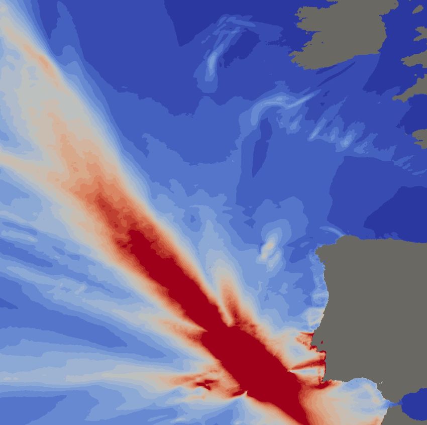
3.2   North East Atlantic Tsunami
     The last major tsunami to effect the Atlantic basin is the Lisbon 1755 event. This tsunami was generated by a
     ≈ 8.5 Mw earthquake which occurred on the morning of the 1st November 1755 roughly 100km off the coast
     of Lisbon. The earthquake and subsequent tsunami caused a large number of fatalities and severe damage
     along the coasts of Portugal, Spain and Morocco. The effects of the tsunami were felt across the Atlantic
     basin, with historical reports of the tsunami waves arriving in the Caribbean, United Kingdom and Ireland
     [ODD13]. There is still no general consensus on the exact earthquake parameters for the event. With the effect
     of this event on the Irish coastline in mind a ’reduced’ faster than real time ensemble will be shown. This
     is considered a ’reduced’ ensemble as only six different earthquake sources were selected from the literature
     and only a section of the north east Atlantic was chosen. The initial sea surface was again generated using
     the Okada model [Oka85]. The resolution of the grid is 2 arc minutes and contains ≈ 610,000 cells. Each
     individual simulation is run for 8 hours and then the maximum wave heights at each grid point are outputted.
     The complete run time for the six different tsunami simulations is 93s on two Nvidia V100 GPUs.

                                                                                                               Mean Maximum Wave Height (m)
                                                                                                               Absolute Maximum Wave Height (m)

Figure 2: Left Figure: Maximum wave heights from each of the six independent simulations. Right Figures: The
combined mean maximum wave heights and absolute maximum wave heights.

         The plots of the maximum wave heights all highlight the impact on the local coastlines of Portugal, Spain
     and Morocco. They however also show a substantial variation in the directionality of the wave energy outside
     the gulf of Cadiz, with some sources showing the wave energy propagating towards the Irish Coastline. The
     absolute and mean maximum wave heights provide a rough estimate at a worst case and most likely scenario
     respectively. They are considered a rough estimate as the ensemble contains so few members. To investigate
     the effect of this event on the Irish coastline the sources introduced in the above figure will be investigated
     further.

                                                           4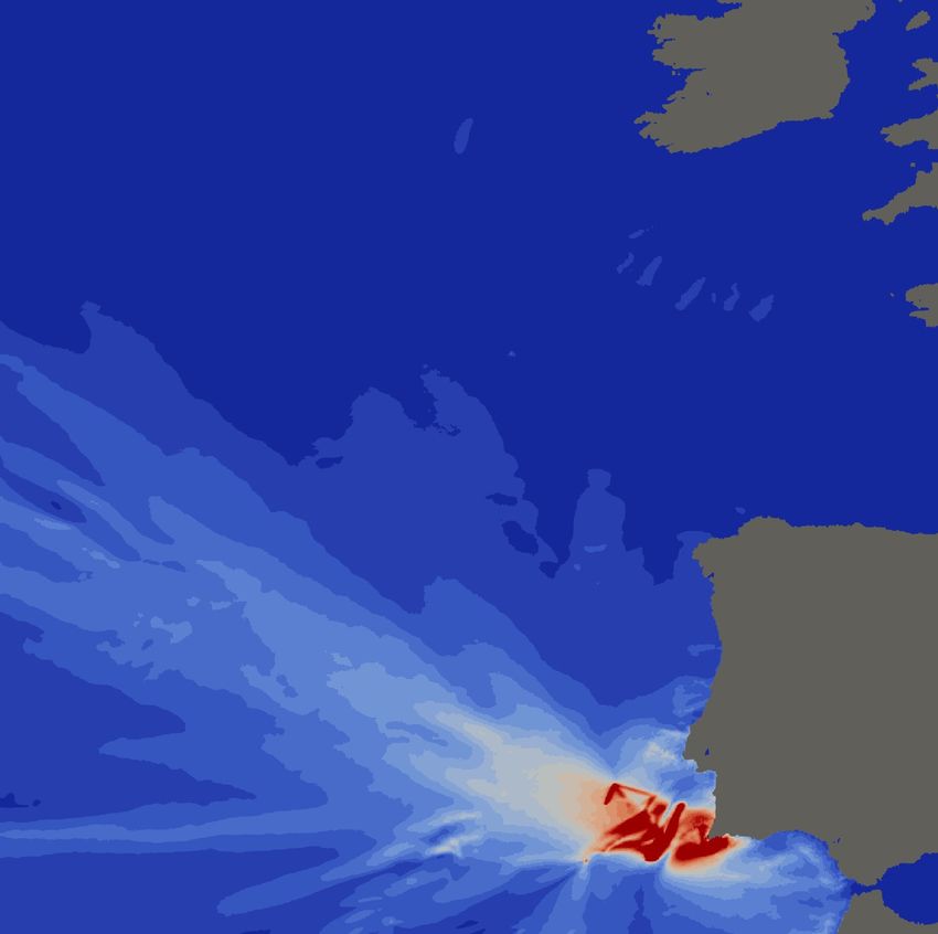
4     High Resolution Inundation Mapping
     4.1   Most Impactful Earthquake Source
     From an Irish perspective the main tsunami threats lie in a Lisbon type event or a tsunami originating from
     a Mid-Atlantic submarine landslide. Extensive studies have been carried out on the collapse of the Rock-
     all bank slide complex (located off the north-west coast of Ireland) and the subsequently generated tsunami
     [SGGD17]. However, this inundation mapping study focuses on earthquake generated tsunamis and from an
     Irish perspective the Lisbon 1755 event can be considered a worst case scenario.
          Previous work on the effects of the Lisbon tsunami have highlighted the vulnerable sections of the Irish
     coastline to be the west (Galway Bay) and south east (Dunmore East) coastlines (areas highlighted in Fig 3).
     The south-east area was chosen based on a previous study [HR 06] which highlighted that this area was prone
     to tsunami amplification. The west coast was selected based on tsunami simulations carried out by the French
     tsunami warning Centre (CENALT). The CENALT simulations showed that the tsunami wave is directed into
     Galway Bay and amplified because of refraction from the Porcupine Bank. The reduced ensemble results (Fig
     2) corroborate these findings, with the main tsunami energy impacting the west and south east coastline of
     Ireland. To build on the reduced ensemble, the sources which exhibited higher impact (maximum wave height)
     on the Irish coastline were chosen (Table 4.1). These sources were then re-run on a non-uniform mesh which
     is refined around the areas of interest (Fig 4). The resultant maximum wave height plots (Fig 6) and outputs at
     various wave gauges (Fig 5) allowed the most impactful source to be deduced. This source was then used for
     the high resolution inundation mapping (section 4.3) and can represent a reasonable worst case scenario.

Figure 3: Zoom in on the bathymetry around the coast of Ireland, with the areas of interest; Galway Bay and
Dunmore East highlighted by the red squares. The location of various wave gauges are highlighted by the blue
stars.

                                                           5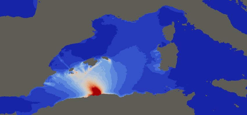
Figure 4: Non-uniform unstructured mesh which is refined near the coastlines and the areas of interest; Galway
Bay and Dunmore East. The most impactful source on the Irish coastline is deduced from simulations with this
mesh.

         Description of Source Parameters
                    Source     Length(km)    Width(km)     Dip (°)   Strike (°)   Slip (m)   Rake (°)
                  1 (MPTF)         105            55          24       21.7         20         90
                   1 (GB)           96            55          45        70          20         90
                    2 (HF)         165            70          35       42.1         15         90
                    3 (HF)         270            45          70       44.2        22.5        90
                  4 (GorB)         200            80          40        50         13.1        90
         • Source 1: A composite source which was first proposed by Baptista et al [BMCZ03]. It involves the si-
           multaneous rupture of the Guadalquivir Bank Fault (GB) and Marquês de Pombal Thrust Fault (MPTF).

         • Source 2: The second source involves the rupture of the Horseshoe Fault (HF) and has been purposed by
           Baptista et al. [BMOA11] for a tsunami inundation study of the Lisbon downtown area. The source was
           scaled in order to obtain rupture parameters comparable to those outlined by Solares and Arroyo [ML04].

         • Source 3: The third source has been described by BRGM (Bureau de recherches géologiques et minières)
           in a pilot study for the TANDEM project (http://www-tandem.cea.fr) and also involves the HF.

         • Source 4: A source purposed by [GBB+ 07] that involves the rupture of the Gorringe Banks (GorB).

          It can be seen from the maximum wave heights (Fig 6) that the overall wave energy directionality of
      the tsunami is consistent across sources (2 − 4). Source 1 fails to produce signs of refraction of the wave
      by the Porcupine Bank at the wave height scale used (Fig 6). It is interesting to note the presence of wave
      amplification as it propagates onto the continental shelf. This phenomenon has been observed elsewhere and
      has been reproduced in experimental set ups [KY18]. Based on the selected wave gauge plots (Fig 5) and the

                                                          6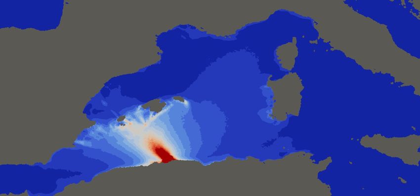
maximum wave heights (Fig 6), the candidate source was chosen to be source 3, which has been proposed by
      BRGM. It can be seen from the wave gauge plots (Fig 5) that this source produces the maximum wave heights
      along the Irish coastline, with the maximum wave height of ≈1m being produced at Dunmore East. This source
      will now be used for the high resolution inundation mapping simulation.
          It should be noted that from these results the south coastline was also highlighted for its vulnerability to
      tsunami impact. Unfortunately, high resolution topography data was unavailable to the authors at the time that
      this pilot inundation study was carried out.

Figure 5: Wave gauge plots from selected locations around the coastline in Ireland. Top row: Wave surface
elevations from the four different sources at wave buoys located off the coast of Ireland. Middle Row: Water
surface elevations from the four different sources at gauges located in Galway Bay. Bottom Row: Water surface
elevations from the four different sources at gauges located in the Dunmore East area.

                                                             7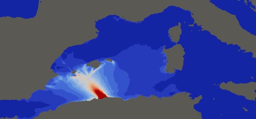
Figure 6: Zoom in on the maximum wave heights simulated for the four sources around the coast of Ireland. The
numerical wave gauges and the areas of interest are highlighted in each plot. Top Left: Source 1, Top Right:
Source 2, Bottom Left: Source 3 and Bottom Right: Source 4.

                                                     8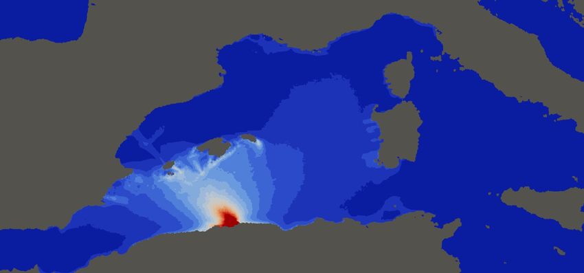
4.2   High Resolution Meshes
     High resolution bathymetry/topography grids (≈ 10m) for the Galway Bay and Dunmore East areas were used
     in the generation of the unstructured meshes for Volna-OP2. The topography for the grids was obtained from
     raw LiDAR data. In order to ensure that the bathymetry and LiDAR data was continuous, all the LiDAR data
     was referenced to WGS84 (a global coordinate system) and then locally vertically referenced to OD Malin.
     Two separate high resolution (25km-10m) meshes for the Galway and Dunmore East coastlines were then
     generated.
         The nonuniform unstructured meshes (Fig 4 and Fig7) were generated using a customised mesh sizing
     function and the GMSH software [GR09]. The mesh sizing function spilts the domain into three separate
     regions: offshore, onshore and port region (area of interest). In the offshore region the mesh size is calculated
     based on the bathymetry value b(x, y). Onshore cell sizes are dependent on the distance to the coastline while
     in the area of interest a fixed cell size is used. Full details on the mesh sizing function are given in [GHG20].

Figure 7: Size of mesh triangles in the unstructured mesh, Left: Galway Bay (25km-10m) and Right: Dunmore
East (25km-10m). The differences can be seen in the concentration of 10 m resolution triangles surrounding
Galway Bay and Dunmore East in the left and right plots.

  Figure 8: Zoom in on the high resolution mesh generated for, Left: Galway Bay and Right: Dunmore East.

                                                            9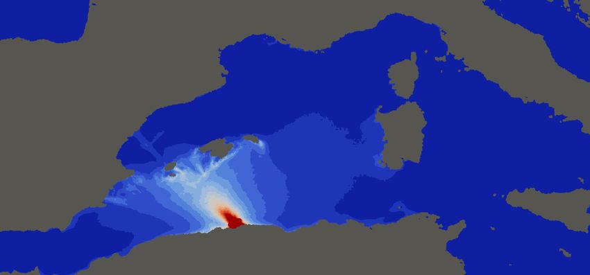
4.3     Inundation Maps
     The following inundation maps highlight land areas which were inundated during the high resolution simu-
     lations (≈ 10m resolution). The grey points indicate cells which were inundated during the simulation. The
     maximum run-up height was calculated to be ≈ 3.4m for both the Dunmore East and Galway Bay areas. It
     should be noted that the simulations with these highly non-uniform meshes were extremely dependent on the
     Courant-Friedrich-Levant (CFL) parameter used. Too high of a CFL condition and the numerical simulation
     became unstable, while too low of a value and the tsunami signal became diffused and dispersed. Thus, multi-
     ple preliminary runs were needed to optimise for this parameter.

     4.3.1   Galway Bay
     Figure (9) highlights the areas of inundation for the Galway Bay region. It can be seen that the model predicts
     inundation at Kinvarra, Clarinbridge and Oranmore (marked on map). Further it predicts little inundation at
     Galway itself, the lack of high resolution bathymetry/topography in the Galway city area (Mutton Island) could
     be responsible for this.

Figure 9: Inundation maps for Galway Bay: the grey areas on the map are land values which were inundated
during the simulation.

                                                           10
4.3.2 Dunmore East
Figure (10) highlights the areas of inundation for the Dunmore East region. The areas of inundation include
Tramore, Saltmills and near the Great Island Power Station. It should be noted that the flow in the River Barrow
was not modelled in these simulations. This river flow could lead to the formation of a bore and thus allow
the tsunami wave to propagate further up the river. The maximum water height at the Waterford coastline is
predicted to be ≈ 1.2m. The maximum run-up height was calculated to be ≈ 3.4m.
Figure 10: Inundation maps for Dunmore East: the grey areas on the map are land values which were inundated
during the simulation.
5 Concluding remarks
The massively parallelised Volna-OP2 code is shown here to be a candidate code which could be implemented
into a Tsunami Warning Centre’s workflow. It is shown to produce extremely rapid regional forecasts for
the Mediterranean Sea. The 2003 Boumerdes earthquake was chosen to act as an example for this process.
Most tsunami warning centres now have access to substantial pre-computed databases of potential earthquake
sources (1,000s of unit sources) and resultant tsunami wave heights [GHLH13]. Once a tsunami is detected,
any relevant sources in the database can become an input into an ’on the fly’ ensemble with Volna-OP2 being
the tsunami code kernel. The resultant absolute maximum and mean wave height plots can augment the results
from the pre-computed database. The results presented here for the ’on the fly’ ensembles are acknowledged
to be preliminary and major effort in developing efficient workflows around the code is needed. However, it is
clear that Volna-OP2 has promising potential when it comes to this respect.
The codes capability at producing high resolution inundation studies is explored in section (4). This pilot
inundation study highlights recent efforts to increase the tsunami hazard assessment for the Irish coastline.
As stated, the main tsunami hazard for Ireland lies with a repeated Lisbon 1755 type event or a mid-Atlantic
11submarine landslide. The inundation study presented here assumes the Lisbon 1755 event as a worst case
scenario and examines the potential inundation of sections of the Irish coastline from such a scenario. The
impacts of various earthquake sources proposed in the literature are explored and the one which produced
the highest maximum wave heights for the Irish coastline and at various gauge points was chosen for the
inundation study. Utilising non-uniform unstructured meshes a high resolution simulation of the areas of
interest was achieved with Volna-OP2. It was found that these high resolution inundation simulations were
extremely dependent on the CFL condition, and thus required multiple preliminary runs to optimise for.
The tsunami hazard assessment of the Irish coastline is considered a pilot study on the extent of inundation
for the most vulnerable sections of the Irish coastline from a Lisbon type event. The results shown corroborate
previous studies on what sections of coastline (the west and south east) are particularly vulnerable. The assess-
ment found that inundation was constrained to low-lying areas in the Dunmore East and Galway Bay regions,
with a maximum run-up of ≈ 3.4m for both regions. The depth of water above the underlying topography
(inundation depth) reached 2m in parts. This level of inundation could pose a risk to various infrastructures
(Great Island Power Station) and members of the public located near the shoreline. To date the above pilot
study provides the best estimate of assessing the hazard associated with a Lisbon type tsunami event on the
Irish coastline. However, it is acknowledged that to provide a full hazard assessment of the Irish coastline,
some further sites (south coast) and factors should be included, such as tidal forcing, ’street level’ inundation
and the effect of wave dispersion. Thus, the inundation plots produced should only be used as a guidance on
the potential tsunami hazard of an area.
Acknowledgments
The authors wish to acknowledge the DJEI/DES/SFI/HEA Irish Centre for High-End Computing (ICHEC) for
the provision of computational resources. Daniel Giles would like to acknowledge the support of the Gov-
ernment of Ireland Postgraduate Scholarship GOIPG/2017/68 from the Irish Research Council. The authors
acknowledge funding and marine bathymetry and coastal LiDAR data from Geological Survey Ireland.
References
[BDA+ 04] A. Bounif, C. Dorbath, A. Ayadi, M. Meghraoui, H. Beldjoudi, N. Laouami, M. Frogneux, A. Sli-
mani, P. J. Alasset, A. Kharroubi, F. Ousadou, M. Chikh, A. Harbi, S. Larbes, and S. Maouche.
The 21 May 2003 Zemmouri (Algeria) earthquake Mw 6.8: Relocation and aftershock sequence
analysis. Geophysical Research Letters, 31(19):2–5, 2004.
[BG16] J. Beck and S. Guillas. Sequential Design with Mutual Information for Computer Experiments
(MICE): Emulation of a Tsunami Model. SIAM/ASA Journal on Uncertainty Quantification,
4(1):739–766, 2016.
[BMCZ03] M. A. Baptista, J. Miranda, F. Chierici, and N. Zitellini. New study of the 1755 earthquake source
based on multi-channel seismic survey data and tsunami modeling. Natural Hazards and Earth
System Science, 3:333–340, 2003.
[BMOA11] M. A. Baptista, J. Miranda, R. Omira, and C. Antunes. Potential inundation of Lisbon downtown
by a 1755-like tsunami. Natural Hazards and Earth System Science, 11(12):3319–3326, 2011.
[DPD11] D. Dutykh, R. Poncet, and F. Dias. The VOLNA code for the numerical modeling of tsunami
waves: Generation, propagation and inundation. European Journal of Mechanics, B/Fluids,
30(6):598–615, 2011.
[GBB+ 07] R. Grandin, J. F. Borges, M. Bezzeghoud, B. Caldeira, and F. Carrilho. Simulations of strong
ground motion in SW Iberia for the 1969 February 28 (Ms = 8.0) and the 1755 November 1 (M∼
8.5) earthquakes - II. Strong ground motion simulations. Geophysical Journal International,
171(2):807–822, 2007.
[GBB+ 17] A. Grezio, A. Babeyko, M. A. Baptista, J. Behrens, A. Costa, G. Davies, E. L. Geist, S. Glimsdal,
F. I. González, J. Griffin, C. B. Harbitz, R. J. LeVeque, S. Lorito, F. Løvholt, R. Omira, R. Mueller,
C.and Paris, T. Parsons, J. Polet, W. Power, J. Selva, M. B. Sørensen, and H. K. Thio. Probabilistic
Tsunami Hazard Analysis: Multiple Sources and Global Applications. Reviews of Geophysics,
55(4):1158–1198, 2017.
[GHG20] D. Gopinathan, M. Heidarzadeh, and S. Guillas. Probabilistic Quantification of Tsunami Currents
in Karachi Port, Makran Subduction Zone, using Statistical Emulation. Earth and Space Science
Open Archive, 2020.
12[GHLH13] A. Gailler, H. Hébert, A. Loevenbruck, and B. Hernandez. Simulation systems for tsunami wave
propagation forecasting within the French tsunami warning center. Natural Hazards and Earth
System Sciences, 13(10):2465, 2013.
[GKS+ 20] D. Giles, E. Kashdan, D.M Salmanidou, S. Guillas, and F. Dias. Performance analysis of Volna-
OP2 – massively parallel code for tsunami modelling, 2020.
[GMS+ 11] M. B. Giles, G. R. Mudalige, Z. Sharif, G. Markall, and P. HJ. Kelly. Performance analysis
and optimization of the OP2 framework on many-core architectures. The Computer Journal,
55(2):168–180, 2011.
[GP06] E. L. Geist and Tom Parsons. Probabilistic Analysis of Tsunami Hazards*. Natural Hazards,
37(3):277–314, Mar 2006.
[GR09] C. Geuzaine and J-F. Remacle. Gmsh: A 3-D finite element mesh generator with built-in pre-
and post-processing facilities. International Journal for Numerical Methods in Engineering,
79(11):1309–1331, 2009.
[GSD+ 18] S. Guillas, A.a Sarri, S. J. Day, X. Liu, and F. Dias. Functional emulation of high resolution
tsunami modelling over Cascadia. Ann. Appl. Stat., 12(4):2023–2053, 12 2018.
[GVR+ 17] D. Gopinathan, M. Venugopal, D. Roy, K. Rajendran, S. Guillas, and F. Dias. Uncertainties
in the 2004 Sumatra–Andaman source through nonlinear stochastic inversion of tsunami waves.
Proceedings of the Royal Society of London A: Mathematical, Physical and Engineering Sciences,
473(2205), 2017.
[HR 06] HR Wallingford, British Geological Survey, and Proudman Oceanographic Laboratory. Tsunamis
– Assessing the Hazard for the UK and Irish Coasts. Technical report, DEFRA (Department for
Environment, Food and Rural Affairs), Flood Management Division, London, UK, 2006.
[KY18] J. Knowles and H. Yeh. On shoaling of solitary waves. Journal of Fluid Mechanics, 848:1073–
1097, 2018.
[LG17] X. Liu and S. Guillas. Dimension Reduction for Gaussian Process Emulation: An Application to
the Influence of Bathymetry on Tsunami Heights. SIAM/ASA Journal on Uncertainty Quantifica-
tion, 5(1):787–812, 2017.
[LLM+ 19] F. Løvholt, S. Lorito, J. MacÍas, M. Volpe, J. Selva, and S. Gibbons. Urgent tsunami comput-
ing. Proceedings of UrgentHPC 2019: 1st International Workshop on HPC for Urgent Decision
Making - Held in conjunction with SC 2019: The International Conference for High Performance
Computing, Networking, Storage and Analysis, 823844(823844):45–50, 2019.
[MGR+ 12] G.R. Mudalige, M.B. Giles, I. Reguly, C. Bertolli, and P.HJ. Kelly. OP2: An active library
framework for solving unstructured mesh-based applications on multi-core and many-core archi-
tectures. In Innovative Parallel Computing (InPar), 2012, pages 1–12. IEEE, 2012.
[ML04] J.M Martı́nez Solares and A. López Arroyo. The great historical 1755 earthquake. Effects and
damage in Spain. Journal of Seismology, 8(1):275–294, 2004.
[MMC+ 04] M. Meghraoui, S. Maouche, B. Chemaa, Z. Cakir, A. Aoudia, A. Harbi, P. J. Alasset, A. Ayadi,
Y. Bouhadad, and F. Benhamouda. Coastal uplift and thrust faulting associated with the Mw =
6.8 Zemmouri (Algeria) earthquake of 21 May, 2003. Geophysical Research Letters, 31(19):2–5,
2004.
[ODD13] L. O’Brien, J. M. Dudley, and F. Dias. Extreme wave events in Ireland: 14 680 BP – 2012.
Natural Hazards and Earth System Science, 13(3):625–648, 2013.
[Oka85] B. Okada. Surface deformation due to shear and tensile faults in a half-space. Bulletin of the
Seismological Society of America, 75(4):1135, 1985.
[RGG+ 18] I.Z. Reguly, D. Giles, D. Gopinathan, L. Quivy, J. H. Beck, M. B. Giles, S. Guillas, and F. Dias.
The VOLNA-OP2 tsunami code (version 1.5). Geoscientific Model Development, 11(11):4621–
4635, 2018.
[SCC05] F. Semmane, M. Campillo, and F. Cotton. Fault location and source process of the Boumerdes,
Algeria, earthquake inferred from geodetic and strong motion data. Geophysical Research Letters,
32(1):1–4, 2005.
[SGGD17] D. M. Salmanidou, S. Guillas, A. Georgiopoulou, and F. Dias. Statistical emulation of landslide-
induced tsunamis at the Rockall Bank, NE Atlantic. Proceedings of the Royal Society A: Mathe-
matical, Physical and Engineering Sciences, 473(2200), 2017.
[WC94] D. L. Wells and K. J. Coppersmith. New empirical relationships among magnitude, rupture length,
rupture width, rupture area, and surface displacement. Bulletin - Seismological Society of Amer-
ica, 84(4):974–1002, 1994.
13[YLM+ 04] K. Yelles, K. Lammali, A. Mahsas, E. Calais, and P. Briole. Coseismic deformation of the May
21st, 2003, Mw = 6.8 Boumerdes earthquake, Algeria, from GPS measurements. Geophysical
Research Letters, 31(13), 2004.
14You can also read