REVIEWING THE INTENSITY DISTRIBUTION OF THE 1933 EARTHQUAKE (MAIELLA, CENTRAL ITALY). CLUES ON THE SEISMOGENIC FAULT - AIQUA
←
→
Page content transcription
If your browser does not render page correctly, please read the page content below
Available online http://amq.aiqua.it
 ISSN (print): 2279-7327, ISSN (online): 2279-7335

 Alpine and Mediterranean Quaternary, 32 (2), 2019, 1 - 8           https://doi.org/10.26382/AMQ.2019.05

                                       REVIEWING THE INTENSITY DISTRIBUTION OF
                                    THE 1933 EARTHQUAKE (MAIELLA, CENTRAL ITALY).
                                           CLUES ON THE SEISMOGENIC FAULT

                                                         Paolo Galli 1, Francesca Pallone 2
                                                     1
                                                         Dipartimento della Protezione Civile, Roma, Italy.
                                                                    2
                                                                      ANAS SpA Roma, Italy.

                                             Corresponding author: P. Galli

ABSTRACT: Here we deal with the study of a strong earthquake occurred in 1933 in the mountainous area of the Maiella massif
(Abruzzi, central Italian Apennines). We carried out original archive researches that allowed to evaluate a novel macroseismic
field, and new parameters for this earthquake (Io=Imax 9 MCS; Mw 6.01±0.07; epicentral coordinate: N42.050°, E14.191°). Then
we compared its highest intensity distribution of this event with the known, active normal fault of the region, finding any possible
matching with none of these. Therefore, considering the subsurface tectonic interpretation provided by the recent scientific literatu-
re, we hypothesize that a possible seismogenic structure for both the 1933, and the catastrophic 1706 event (Mw 6.9; roughly
same 1933 epicenter) is the blind backthrust that developed during Early-Middle Pleistocene in the footwall of the Maiella anticline.

Keywords: 1933 earthquake; macroseismology; compressive tectonics; Maiella massif

1. INTRODUCTION                                                                          here we carried out a reappraisal of all the data quoted
                                                                                         or reported in the Italian seismic databases (e.g.,
      At dawn of September 26 1933 (4:33 local time,                                     DBMI15, 2016; CFTI5Med, 2018; ASMI, 2019). As the
3:33 GMT) a strong earthquake struck the southeastern                                    previous studies were mainly based upon the infor-
area of the Maiella massif (Abruzzo, central Italian Ap-                                 mation listed in few newspapers and on the works of
ennines), damaging heavily several villages, and caus-                                   Cavasino (1935a; 1935b) and Margottini et al. (1992),
ing extensive destruction in few localities, as in Lama                                  we also performed farther archive and library researches
dei Peligni, Taranta Peligna, and Civitella Messer Rai-                                  that allowed us to collect new, original and reliable data.
mondo. The mainshock was closely preceded by two
foreshocks that - alarming the inhabitants of the region -                               2. MATERIALS AND METHODS
prompted most of them to escape from their houses,
and to pass the night outsides their fragile, old stone-                                        With the aim of completing the information con-
masonry houses. Therefore, in spite of the large amount                                  cerning the damage within each municipality, firstly we
of collapses and destructions (Fig. 1), this yielded a                                   carried out an extensive reading of contemporary peri-
relatively little death toll (12 casualties), and less than                              odical publications at the Central National Library of
two hundred injured.                                                                     Rome, where we collected useful information reported
      Two centuries before, in 1706, the same region                                     inside 15 Italian newspapers (i.e., Il Mattino; Il Giornale
was hit by one of the strongest and deathful earthquake                                  d’Italia; La Nazione; Il Popolo d’Italia; Il Popolo di Roma;
in the Italian history (Io 10.5; Mw=6.8. More than 2200                                  Il Regime Fascista; il Corriere della Sera; La Tribuna;
victims). Interestingly, the two events share a similar                                  l’Osservatore Romano; la Gazzetta del Popolo; Roma;
mesoseismic area, the older presenting much higher                                       L’Avvenire d’Italia; il Lavoro Fascista; il Tevere; il Mes-
site intensities. Although the seismogenic sources of                                    saggero), for a total of 58 articles specifically dealing
both earthquakes have remained unknown so far, giving                                    with the earthquake. We also found generic information
the similarity of the respective Highest Intensity Data-                                 on French papers at the National Library of France
points Distribution (HIDD), it is possible that they could                               (Paris), as in Le Journal, Le Populaire and L'Ouest-
share segments of the same fault system.                                                 Éclair.
      In order to enhance the knowledge concerning the                                          Although newspapers contain first-hand news and
highest intensity distribution (Is≥ 7 MCS) of the 1933                                   accounts, we have found that the information were often
earthquake, and thus indirectly enlighten the rough loca-                                qualitative, reporting just the number of victims in each
tion of its causative fault (and hopefully the 1706 one),                                village, the number of injured people, and a rough
2                                                                                                                         Galli P. & Pallone F.

Fig. 1 - View of the collapse of some poor stone-masonry houses in a village east of the Maiella Massif (left; L’Illustrazione Italiana, 1933)
and in Lama dei Peligni (right; photo Keystone-France/Abruzzes/gettyimages).

framework of the destroyed houses and of those still                        level of damage existing in each locality, providing also
inhabitable. It is worth noting that, similarly to what hap-                complementary data in places not fully covered by other
pened three years before after the so-called Vulture                        sources.
earthquake (July 23, 1930; Mw 6.7, southern Italian                               Nevertheless, one of the most important and novel
Apennines. See Castenetto & Sebastiano, 2002), Italian                      data in our study derives from the huge mass of infor-
press-reporters widely emphasized the prompt rescue                         mation collected by Ridolfi (2005), who was previously
and assistance provided to the inhabitants by the Fas-                      ignored in any seismic compilation. Her work is entirely
cist government and by the local authorities. And then,                     devoted to the effects that the 1933 earthquake had on
as in 1930, in spite of the severe damage scenario, the                     the region surrounding the Maiella massif (Abruzzo
whole national press suddenly minimized the event,                          side). Data were mainly collected in archives and librar-
which soon disappeared from all the newspapers pages.                       ies, such as: Central State Archive; State Archive of
The spirit of the times is well condensed in a telegram,                    Chieti; State Archive of Pescara; historical archive of
sent on October 1 by the Italian Prime Minister to the                      Banco di Napoli; historical Archive of the municipality of
Minister of the Public Works, which just says: "Go for a                    Avezzano; archive of the Superintendency of Public
ride in the earthquake zone - Mussolini", clearly implying                  Works; Library of the Chamber of Deputies; Library of
to minimize anything (Fig. 2).                                              the Ministry of Agriculture; Library of the Bank of Italy;
      We also made researches inside the former ar-                         archive of the Chamber of Commerce, Industry, Agricul-
chive of the Civil Protection Department where - besides                    ture and Crafts of Chieti.
a large amount of telegrams sent by the Prefects to the                           By ordering and systematizing all of these huge
Interior Ministry, mostly containing the early news on the                  amount of valuable information, it was possible to pre-
earthquake effects - we have found an enormous quan-                        cisely estimate the number of building affected by each
tity of documents attesting the requests of economical                      specific damage level (e.g., light, moderate and severe
support sent by each single citizens, their associated                      damage, destruction, collapse), and thus evaluate the
technical expertise, and, sometime, the answers provid-                     intensity degree according to the Mercalli-Cancani-
ed by the authorities in the following months or years.                     Sieberg (MCS) scale, published just three years before
Most of this information supported the evaluation of the                    by Sieberg (1930). As explained in the following, to do

Fig. 2 - The telegram sent by Benito Mussolini to Araldo di Crollalanza, Minister of the Public Works: “Go for a ride in the earthquake zone”.
It is quite clear the intent to minimize the effects of the earthquake. (Civil Protection Department Archive).
Reviewing the intensity distribution of the 1933 earthquake (Maiella, central Italy) 3
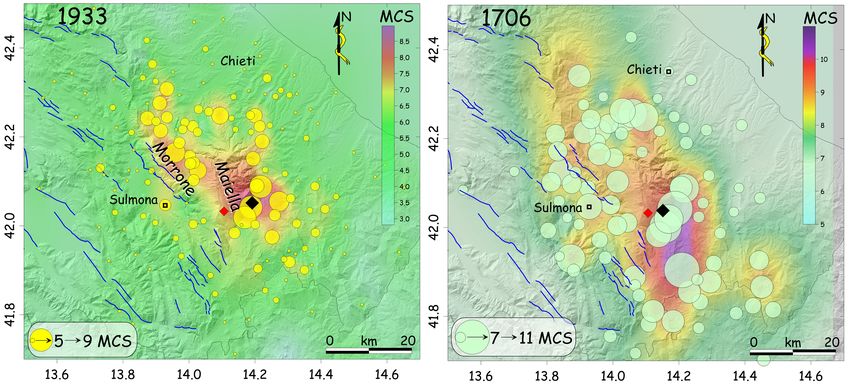
Fig. 3 - Left, distribution of the highest intensities distribution re-evaluated here for the 1933 earthquake (yellow circles proportional to Is 5-
9 MCS). Background colors suggest the areal distribution of the intensities (see MCS scale; kriging interpolation); black rhomb is the mac-
roseismic epicenter calculated through Boxer4 algorithm (Gasperini et al., 1999); red rhomb is the instrumental epicenter (Palombo, 2010).
Right, same image for the 1706 earthquake (unpublished data of the authors); black rhomb is the 1706 macroseismic epicenter (Boxer4
algorithm); red rhomb is again the 1933 instrumental epicenter. Blue lines in both panels are the normal active faults of the region, all SW
dipping (mod. From Galli & Peronace, 2014). Note that intensities span between 7-11 MCS in the 1706 panel vs 5-9 MCS in the 1933
panel.
this, we analytically applied the method suggested by pared analytically our intensities with those in Cavasino
Molin (2009), that considers the percentage of each (1935b), calculating thus a linear regression between
damage level (1-5) as representative of every MCS the two datasets. Then, by applying the resulting equa-
degree (from 5 to 11 MCS). tion, we obtained a Is value for the lacking intensities
consistent with our macroseismic evaluation (Tab. 1).
3. RESULTS The new areal distribution of the highest intensity
datapoints (Fig. 3, left) provides a slightly different image
First of all, for each singe locality, we obtained the of the mesoseismic area then before, although it re-
percentage of buildings affected by the different levels mains strongly focused on the Maiella massif, with a
of damage that we mainly deduced from the analytical macroseismic epicenter (black rhomb in Fig. 3) falling
data contained in the Ridolfi’s (2005) work, filling the close to Lama dei Peligni. This epicenter falls ~7 km
gaps with information collected from newspapers, tele- away from that calculated by Palombo (2010) by using
grams and other primary sources found in the archive of the time arrivals of P and S-wave phases reported in the
the Civil Protection Department. Then we transformed ISS bulletins, and coupled with the NonLinLoc code
these percentages in MCS degree, considering damage (Lomax et al., 2000), with this point assumed as the
levels 2-3 (i.e., from moderate to severe damage, not maximum likelihood instrumental location for the 1933
distinguishable singularly in most of the documentary earthquake.
materials), 4 (destruction, and/or irreparable damage), The epicentral intensity can be evaluated around Io
and 5 (collapse) in the percentage progression pro- 9 MCS, as in CPTI15 (2016) and CFT5Med (2018), with
posed by Molin (2009). This allowed us to obtain robust coordinates of N42.050°, E14.191°. In turn, the equiva-
intensities estimates (see Tab. 1) that generally move lent magnitude that we have calculated by applying
away from those reported in DBMI15 (2016) and BOXER4 algorithm (Gasperini et al., 1999) is Mw
CFTI5Med (2018) by just 0.5-1 degrees or, exceptional- 6.01±0.07 (5.9±0.07 in CPTI15; 6.05±0.1 in CFT5Med;
ly, 1.5 degree. 6.4±0.3 in Palombo, 2010), with a source length of 13
It is worth noting that in the previous studies many km striking N30°±13°, that is perpendicular and external
intensity datapoints were derived uncritically from a to all the main extensional, NW-SE active fault of central
crude list published by Cavasino (1935b), who likely Apennines (Fig. 3).
estimated the MCS intensities on the basis of the fresh Last but not least, we have found a novel and inter-
information gathered brevi manu from the local authori- esting information concerning surface effects produced
ties of the time, leaving any written description of the by the earthquake. This regards the damage suffered by
effects felt by these localities. Therefore, in order to a tunnel of the Sulmona-Roccaraso line, that caused the
complete the dataset of our datapoints - that mainly stop of the trains between the stations of Campo di
lacks the lowermost intensities - we also decided to Giove and Palena (green circle in Fig. 4)
consider those published by Cavasino (1935b). Howev-
er, before including tout court these intensities, we com-
4                                                                                                                Galli P. & Pallone F.

Tab. 1 - MCS intensities (Is) related to the 26 September 1933 mainshock. Lon and Lat are WGS84 geographic coordinate of centroid of
locality.

Reviewing the intensity distribution of the 1933 earthquake (Maiella, central Italy)                                                              5

4. DISCUSSION AND CONCLUSIONS                                                               Maiella massif alters the perception of the real shaking
                                                                                            distribution, although it is clear that the strongest ground
      Observing the left panel of Fig. 3, we notice that                                    acceleration is confined in the Adriatic side of the Morro-
the highest site intensities of the 1933 earthquake fall at                                 ne-Maiella ridge.
the base of the eastern edge of the Maiella massif (i.e.,                                         Definitively, this means that none of the ~west dip-
Taranta dei Peligni, Lama dei Peligni, and Civitella Mes-                                   ping active normal faults of the region (i.e., all the blue
ser Raimondo, all with Is 9 MCS; see Tab. 1), decreas-                                      lines in Fig. 3 - 4) can be the source of this earthquake.
ing then progressively eastward and northward. Intensi-                                     Indeed, the 1933 HIDD is fully concentrated in the foot-
ties 7-8 MCS also characterize the eastern flank of the                                     wall of these structures, in contrast to all the earth-
Morrone ridge, with a peak of Is 8.5 MCS in Salle Vec-                                      quakes of the Italian Apennines, the HIDD of which fall
chia, where diffuse landsliding, more than shaking, con-                                    always in the hangingwall of their causative faults (e.g.
tributed to the severe damage framework. Obviously,                                         in Galli & Galadini, 1999; Galli et al., 2009; 2017).
the lack of localities in the mountainous zones of the                                            As far as the possible 1933 and 1706 sources are

Fig. 4 - A, shaded relief map of central Apennines with the major historical seismicity (red circles, Mw>5.0; yellow circles, well-dated
Mw>6.5 paleoseismological events; Galli et al., 2015; 2016) and the main, active normal faults (blue lines; mod. from Galli and Peronace,
2014). MFS, Mount Morrone fault system; CF, Caramanico fault. Red rhomb is the 1933 instrumental epicenter (Palombo, 2010). Red
triangles-dashed lines suggest the bounding thrust of the Casoli-Bomba (C-B) pop-up and of the buried backthrust below the Maiella anti-
cline footwall (MAFB; inferred northward mimicking the Caramanico fault path; Ghisetti and Vezzani, 2002; Calamita et al., 2009). Dotted
line is the segment of CROP-11 line shown in panel B; green circle indicates the area where the railway tunnel was damaged by the 1933
earthquake. B, part of CROP-11 line interpreted by Patacca et al. (2008). 1, Pleistocene marine deposits of the foredeep basin; 2, Pliocene
marine deposits conformably overlying the Apulia carbonates; 3, Mount Genzana unit; 4, Mount Morrone-Porrara unit; 5, Upper Cretaceous
-Pliocene Mount Queglia unit; 6, Molise units; 7, Lower Pliocene flysch of Maiella unit; 8, Mesozoic-Tertiary carbonates of Maiella unit; 9,
Mesozoic-Tertiary carbonates of Apulia Platform; 10, Paleozoic-Triassic deposits.
6 Galli P. & Pallone F.
concerned, some authors associated these earthquakes SSW, transpressive, right strike-slip fault, i.e., similar to
to two consecutive ruptures of patches of a so-called, the strike of the source resulting from the Boxer4 algo-
SW-dipping Abruzzo Citeriore Basal Thrust (Lavecchia rithm).
& de Nardis, 2010). However, the existence of this Ba- Honestly, at the moment, we can conclude that the
sal Thrust is denied by the interpretation provided by seismogenic sources of these two frightful earthquake
Patacca et al. (2008) of the CROP 11 deep reflection are still uncertain. We can surely exclude that they were
seismic profile, where the entire Pliocene Maiella ramp- generated by any of the known, active normal faults
anticline overlies a popup structure in the Mesozoic- mapped in Fig. 4, and least of all by the Mount Morrone
Tertiary carbonates of the Apulia Platform. This popup is fault system which bounds the eastern side of the Sul-
instead related to an important E-dipping backthrust mona basin (MFS in Fig. 4A). As aforementioned, the
(MAFB in Fig. 4; Patacca et al., 2008), which likely con- HIDD of the 1706 and 1933 events fall in the footwall of
trolled also the growth of the neighboring Casoli-Bomba all these faults, while the Mount Morrone fault, although
high (C-B pop-up in Fig. 4). very close to both epicenters, and partly running inside
According to Patacca et al. (2008), the existence, the 1706 HIDD, sourced its last earthquake in the far 2nd
timing and importance of this blind structure, which de- century AD, as definitely demonstrated by recent paleo-
veloped in the footwall of the Maiella anticline, is testi- seismic studied (Galli et al., 2015).
fied also by the impressive uplift of the Maiella anticline Concluding, our working hypothesis - which makes
just over the backthrust hanging-wall. The uplift started no claims to being conclusive - is that the source of both
in the Early Pleistocene, rising the top of the Maiella 1706 and 1933 events might be the blind backthrust in
carbonate massif at a rate of some centimeters per year the footwall of the Maiella anticline, the geometry of
(i.e., vertical component of the active-thrust slip vector), which matches the HIDD of both events. In this case, it
from few hundred meters a.s.l. to the present elevation is also possible that the Caramanico fault might move
(~2800 m), or more. Another evidence for this is the > passively, inducing some surface rupture, as suggested
3500 m vertical throw accommodated by the Caraman- by the damage in the railway tunnel in 1933. All this
ico normal fault (CF in Fig. 4B; see also Ghisetti & Vez- implies the existence of active, NE-SW compression just
zani, 2002), which could represent a gravity collapse east to the extensional belt highlighted by the active
feature developed in the roof of the passively growing faults shown in Fig. 4B, which is not (yet?) adequately
Maiella tectonic edifice (Patacca et al., 2008). supported by either geological or instrumental data.
If this interpretation is correct, as the HIDD of the
1706 and 1933 earthquakes mainly fall in the broad ACKNOWLEDGMENTS
hanging-wall of this backthrust, one could hypothesize We are grateful to N. Ridolfi who share with us the
that both events were sourced by a residual activity of results of her long work. We thank D. Molin for the use-
this Quaternary structure that, tentatively, could also ful discussion, and the personal of the Archive of the
trigger the passive motion of the Caramanico fault. Like- Dipartimento della Protezione Civile Nazionale of Italy
wise, also other earthquakes occurred in the farther, who supported our research. P. Messina and E. Pero-
backthrust hanging-wall, as the 1881 one (Mw 5.4; Fig. nace provided useful criticism in reviewing the manu-
4A), could have been sourced by structures rooted at script. The views and conclusions contained here are
depth to the sole thrust, for instance those bounding the those of the authors and should not be interpreted as
Casoli-Bomba high (Fig. 4B). necessarily representing official policies, either ex-
Nevertheless, whereas the largest slip of the back- pressed or implied, of the Italian Government.
thrust occurred during the late Emilian-early Sicilian
(Patacca et al., 2008), today we have not geological REFERENCES
evidence for such a persisting activity in its hanging-
wall, with the exception of some morphotectonic indica- ASMI (2019) - Archivio Storico Macrosismico Italiano,
tion suggesting post-Middle Pleistocene anticline grow- Rovida A., Locati M., Antonucci A., Camassi R.
ing (Pomposo & Pizzi, 2009). Even the geodetic data (eds.), Istituto Nazionale di Geofisica e Vulcanolo-
published so far (D’Agostino et al., 2011; D’Agostino, gia, https://emidius.mi.ingv.it/ASMI/
2014; Angelica et al. 2013; Devoti et al., 2011; Galvani Calamita F., Esestime P., Paltrinieri W., Scisciani V.,
et al., 2012) show that the outer Morrone-Maiella region Tavarnelli E. (2009) - Structural inheritance of pre-
is not experiencing NE-SW compression, as GPS vec- and syn-orogenic normal faults on the arcuate
tors located westward and eastward of these massifs geometry of Pliocene-Quaternary thrusts: Exam-
roughly show the same NE velocity. Moreover, there are ples from the Central and Southern Apennine
neither focal mechanisms, nor borehole breakouts in the Chain, Ital.J.Geosci, 128, 381-394.
whole region supporting or ruling out ongoing compres- Castenetto S., Sebastiano M. (2002) - Il regime fascista
sion (e.g. in Mariucci & Montone, 2018). e le calamità naturali, in: Il terremoto del Vulture
Actually, Palombo (2010) tried to calculate the del 23 Luglio 1930, Roma, 49-58.
1933 focal mechanism from eighteen retrieved paper- Cavasino A. (1935a) - I terremoti d’Italia nel trentacin-
seismograms, although only eight had useful P wave quennio 1899-1933, in "Memorie del Regio Ufficio
first motion. Amongst the possible solutions, Palombo Centrale di Meteorologia e Geofisica", s. III, ap-
(2010) evidenced two groups with different kinematics; pendice al vol.4. Roma 1935.
one with average NW-SE trend associate to a NE-SW Cavasino A. (1935b) - Bollettino sismico anno 1933,
tensional axis (i.e., transtensive NE-SW faults), and the fasc.2 (Macrosismi), Regio Ufficio Centrale di Me-
other compatible with a NE-SW compressive field (NNE- teorologia e Geofisica. Roma 1935.Reviewing the intensity distribution of the 1933 earthquake (Maiella, central Italy) 7
CFTI5Med (2018) - Catalogo dei Forti Terremoti in Italia central Italy in 1400 years evidenced by new pa-
(461 a.C.-1997) e nell’area Mediterranea (760 a.C. laeoseismic results, Terra Nova, 28, 146-154.
-1500), E. Guidoboni, G. Ferrari, D. Mariotti, A. Galvani A., Anzidei M., Devoti R., Esposito A., Pietranto-
Comastri, G. Tarabusi, G. Sgattoni, G. Valensise nio G., Pisani A.R., Riguzzi F., Serpelloni E. (2012)
(eds.), Istituto Nazionale di Geofisica e Vulcanolo- - The interseismic velocity field of the central
gia. http://storing.ingv.it/cfti/cfti5/. Apennines from a dense GPS network, Annals of
Doi: 10.6092/ingv.it-cfti5 Geophysics, 55, doi: 10.4401/ag-5634.
CPTI15 (2016) - The 2015 version of the Parametric Gasperini P., Bernardini F., Valensise G., Boschi E.
Catalogue of Italian Earthquakes, Rovida A., Loca- (1999) - Defining seismogenic sources from histo-
ti M., Camassi R., Lolli B., Gasperini P. (eds), Isti- rical felt reports, Bull. Seism Soc. Am., 89, 94-110.
tuto Nazionale di Geofisica e Vulcanologia. https:// Ghisetti F., Vezzani L. (2002). Normal faulting, extension
emidius.mi.ingv.it/CPTI15-DBMI15/. and uplift in the outer thrust belt of the central
Doi: 10.6092/INGV.IT-CPTI15 Apennines (Italy): role of the Caramanico fault,
D’Agostino N. (2014) - Complete seismic release of Basin Research, 14, 225-236.
tectonic strain and earthquake recurrence in the Lavecchia G., de Nardis R. (2010) - Seismogenic sour-
Apennines (Italy), Geophys. Res. Lett. 41. ces of major earthquakes of the Maiella area
Doi: 10.1002/2014GL059230 (central Italy): constraints from macroseimic field
D'Agostino N., Mantenuto S., D'Anastasio E., Giuliani simulations and regional seimotectonics. UR 4.01,
R., Mattone M., Calcaterra S., Gambino P., Bonci DPC-INGV project 2007-2009.
L. (2011) - Evidence for localized active extension Lomax A., Virieux J., Volant P. and Berge C (2000) -
in the central Apennines (Italy) from global positio- Probabilistic earthquake location in 3D and layered
ning system observations. Geology, 39, 291-294. models: Introduction of a Metropolis-Gibbs method
Doi:10.1130/G31796.1 and comparison with linear locations, in Advances
DBMI15 (2016) - The 2015 version of the Italian Macro- in Seismic Event Location Thurber, C.H., and N.
seismic Database, Locati, M., Camassi R., Rovida Rabinowitz (eds.), Kluwer, Amsterdam, 101-134.
A., Ercolani E., Bernardini F., Castelli V., Caraccio- Margottini C., Puglisi C., Sericola A. (1992) - Il terremo-
lo C.H., Tertulliani A., Rossi A., Azzaro R., D’Ami- to del 1933 nell'area della Maiella (Abruzzo-Italia
co S., Conte S., Rocchetti E. (eds.), Istituto Nazio- Centrale). ENEA, rapporto interno, Roma, 24 pp.
nale di Geofisica e Vulcanologia. https:// Mariucci M.T., Montone P. (2018) - IPSI 1.2, Database
emidius.mi.ingv.it/DBMI04/. of Italian Present-day Stress Indicators, Istituto
Doi: 10.6092/INGV.IT-DBMI15 Nazionale di Geofisica e Vulcanologia (INGV).
Devoti R., Esposito A., Pietrantonio G., Pisani A.R., Doi: 10.6092/INGV.IT-IPSI.1.2
Riguzzi F. (2011) - Evidence of large scale defor- Molin D. (2009) - Rilievo macrosismico in emergenza.
mation patterns from GPS data in the Italian sub- Rapporto interno Dipartimento della Protezione
duction boundary. Earth and Planetary Science Civile; Ufficio III Valutazione, prevenzione e mitiga-
Letters 311 (3-4), 1-12. zione del rischio sismico, internal report.
Doi: 10.1016/j.epsl.2011.09.034 Patacca E., P. Scandone E. Di Luzio G. P. Cavinato and
Galli P., Galadini F. (1999) - Seismotectonic framework M. Parotto (2008) - Structural architecture of the
of the 1997-98 Umbria-Marche (Central Italy) ear- central Apennines: Interpretation of the CROP 11
thquakes. Seismological Res. Letters, 70, 4, 404- seismic profile from the Adriatic coast to the oro-
414. graphic divide, Tectonics, 27, TC3006.
Galli P., Camassi R., Azzaro R., Bernardini F., Castenet- Doi:10.1029/2005TC001917
to S., Molin D., Peronace E., Rossi A., Vecchi M., Palombo B. (2010) - Information on Source parameters
Tertulliani A. (2009) - Il terremoto aquilano del 6 of meaningful Italian historical earthquakes estima-
aprile 2009: rilievo macrosismico, effetti di superfi- ted within the SISMOS project framework, Task B
cie ed implicazioni sismotettoniche. Il Quaternario, of UR 4.02, DPC-INGV project 2007-2009.
22, 235-246. Pomposo G., Pizzi A. (2009) - Evidenze di tettonica
Galli P., Castenetto S., Peronace E. (2017) - The macro- recente ed attiva nel settore sepolto dell’Appenni-
seismic intensity distribution of the 30 October no Abruzzese, Rendiconti della Società Geologica
2016 earthquake in central Italy (Mw 6.6): Seismo- Italiana, 5, 176-178.
tectonic implications. Tectonics, 36. 1-13. Ridolfi N. (2005) - Economia di una catastrofe: il terre-
Doi: 10.1002/2017TC00458. moto della Majella in epoca fascista. Collana del
Galli P., Peronace E. (2014) - New paleoseismic data Dipartimento di Economia e Storia del Territorio.
from the Irpinia Fault. A different seismogenic per- Università "G. D'Annunzio" di Chieti-Pescara - F.
spective for southern Apennines (Italy), Earth- Angeli.
Science Reviews, 136, 175-201. Sieberg A. (1930) - Geologie der Erdbeben. Handboch
Galli P., Giaccio B., Peronace E., Messina P. (2015) - der Geophysic, 2, 4, 552-554 [Tabb. 100, 101,
Holocene Paleoearthquakes and Early-Late Plei- 102, 103], Berlin.
stocene Slip-Rate on the Sulmona Fault (Central
Apeninnes, Italy), Bull. Seism. Soc. Am., 105(1), 1- NEWSPAPERS
13.
Galli P., Giaccio B., Messina P., Peronace E. (2016) - Corriere della Sera, 27-28-29-30/09/1933, Milano 1933.
Three magnitude 7 earthquakes on a single fault in Il Giornale d’Italia, 27-28/09/1933; 5-6/10/1933, Roma8 Galli P. & Pallone F.
1933. L’Osservatore Romano, 27-28-29/09/1933; 24/11/1933,
Il Lavoro Fascista, 27- 29/09/1933; 1/10/1933, Milano Città del Vaticano 1933.
1933. La Gazzetta del Popolo, 27-28-29-30/09/1933, Torino
Il Mattino, 27-29/09/1933; 5/10/1933, Napoli 1933. 1933
Il Messaggero, 27-28-29/09/1933, Roma 1933. La Nazione, 27-29/09/1933, Firenze 1933.
Il Popolo d’Italia, 27-28/09/1933; 1-4/10/1933, Milano La Tribuna, 27-28-29-30/09/1933; 24/11/1933, Roma
1933. 1933.
Il Popolo di Roma, 27-29/09/1933, Roma 1933. Roma, 27-28-30/09/1933; 1-3-24/11/1933, Roma 1933.
Il Regime Fascista, 27-28/09/1933; 4/11/1933, Cremona Le Journal, 27/09/1933, Paris, 1933.
1933. Le Populaire, 27/09/1933, Paris, 1933.
Il Tevere, 27-29-30/09/1933; 4-5-26/10/1933; 6-24/11/ L'Ouest-Éclair, 27-28/09/1933, Paris, 1933.
1933, Roma 1933.
L’Avvenire d’Italia , 27/09/1933; 1/10/1933; 24/11/1933,
Bologna 1933.
Ms. received: February 19, 2019
Final text received: March 20, 2019You can also read