Providing Aerial Images through UAVs - University of ...
←
→
Page content transcription
If your browser does not render page correctly, please read the page content below
Fact Sheet, FS-1056
February 2017
Providing Aerial Images through UAVs
Precision agriculture relies on accurate maps of soil which means there is no pilot on board. This
properties and yield potential to uncover high- and characteristic of UAVs has led to a new regulatory
low-yielding sections of a field. Some of these maps environment with privacy concerns.
are obtained by remote sensing (gathering
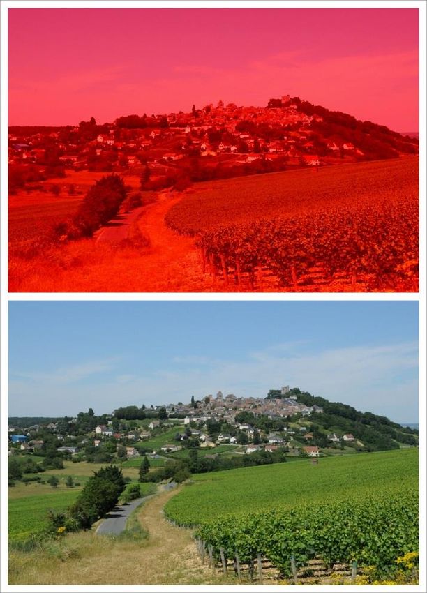
information from a distance), such as photography. Figure 1. The reflectance of light from the red (a)
Since its inception, precision agriculture has relied and visual spectrum (b) can be useful to observe
on remote sensing by planes and satellites to obtain plant health
various types of photos.
Satellites, such as LANDSAT, have provided images
which can be analyzed for plant health by observing
the wavelength of light reflected (Figure 1).1, 2
Normalized Difference Vegetation Index (NDVI) is
one way to analyze plant health, where the
reflectance of near-infrared (NIR) wavelengths are
compared to the visual spectrum (red, green, blue
[RBG]) to measure a plants greenness, or
photosynthetic activity.3
While this data has been valuable to agricultural
and environmental research, obtaining satellite or
aerial imagery can be expensive.2 Satellite images
may also be limited by cloud cover, which is often
associated with the growing season.2
Drones, known to researchers as unmanned aerial
vehicles (UAV), are poised to solve some of these
issues. A UAV can be flown on demand versus
waiting for satellite coverage.3 While similar to a
model plane, UAVs are considered autonomous,
For more information on this and other topics visit the University of Maryland Extension website at www.extension.umd.edu 1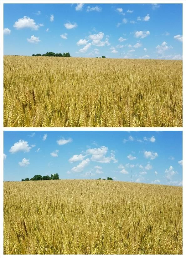
As an emerging technology, UAV costs may be high                 Figure 2. An example of a quadcopter, a rotary
 and actual application relatively unkown.1,2 For                 UAV with four propellers
 field crop, nursery and orchard owners,
 understanding current options is necessary prior to
 fitting into the farm budget.

 Although Gaining in Popularity, UAVs have been
 Part of University, Federal and Private Research
 Programs

 Earlier work has focused on designing systems to
 fly. Some universities have worked on creating their
 own prototypes, while private industry has
 designed commercial products for sale.2,3 Some
 earlier UAVs have included blimps, parachutes and
 kites, but their stability in the air for remote sensing         power must be diverted to the multiple rotors.5,6
 is limited.2,4                                                   This shorter battery life makes rotary UAVs better
                                                                  for smaller fields, although gas-powered UAVs may
 Although terms are often used interchangeably,
                                                                  solve this issue.4,6
 UAS (unmanned aerial systems) is another
 acronym used by researchers. UAS refers to the                   Fixed-wing UAVs use lift and drag to stay afloat and
 UAV as well as all of the equipment and software                 use less battery life, so flight times can be between
 that can be associated. This may include sensors,                1-2 hours (Figure 3). Fixed wings can also reach
 global positioning systems (GPS) and                             greater speeds (70 mph), although this is not
 communications equipment. Software is available                  recommended in order to reduce blur in
 to help guide and plan flights autonomously as well              photographs. While able to cover larger fields,
 as analyze the data.                                             fixed-wing UAVs also require more space to take off
                                                                  and land.4 For a fixed wing, it is recommended to
 Two of the Most Popular UAVs are Known as
 Rotary and Fixed Wing                                            have a soft landing zone, such as soybean canopy.

 Rotary UAVs are similar to helicopters in
                                                                                                       Figure 3. An
 appearance (Figure 2). A rotary UAV is often
                                                                                                       example of a
 identified by the number of rotors (propellers) they                                                  fixed wing
 have (e.g. a quadcopter = four rotors). For                                                           UAV, which is
 agricultural applications, rotary UAVs are excellent                                                  very similar to
 for scouting fields and hovering over chosen points,                                                  an airplane in
 such as research plots. Due to their ability to                                                       appearance
 vertically land and takeoff, rotary UAVs require
 minimal landing space.4

 Limited by flight speed (10-20 mph), rotary UAVs
 are not as stable when winds are greater than 15
 mph5. Battery life is also shorter because more

For more information on this and other topics visit the University of Maryland Extension website at www.extension.umd.edu   2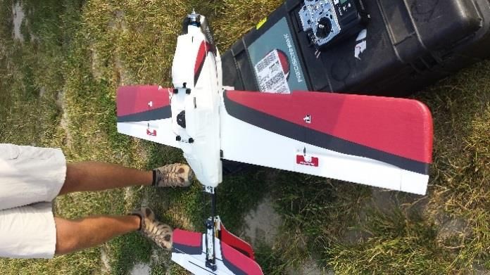
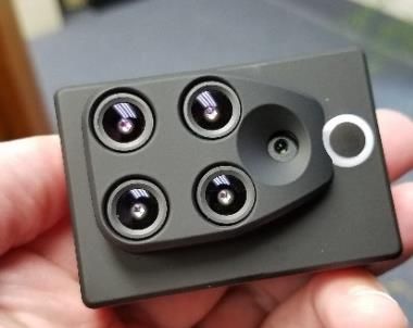
Type of Sensor is Another Important Choice                       A thermal camera picks up variations in heat and
                                                                  can be used to detect livestock or nighttime pests
 Most camera sensors for UAVs are not new                         such as deer.
 technology, but they do need to be adapted to fit
 and perform as needed (Figure 4). Sensors that can               LiDAR (Light Reflection and Ranging) is a laser-
 be used include visual and near-infrared (NIR)                   based sensor that performs similar to radar. It can
 cameras. Having access to multiple bands of light is             measure distance from the UAV to create very
 useful for calculating NDVI, which is the ratio of NIR           accurate maps of elevation (Figure 5).
 minus red bands divided by NIR plus red bands. An
 off-the-shelf digital camera can be adapted for NIR               Figure 5. LiDAR images are developed using a
 images by removing the filter.2,3                                 laser to accurately measure distance. This map of
                                                                   the Coastal Plain shows the detail that can be
 Due to the need of both visual and NIR bands to                   obtained with LiDAR (Photo courtesy of the USDA)
 calculate NDVI, two flights would need to be made
 with separate visual and NIR cameras. This can be
 overcome by using multispectral cameras (Figure
 4), which may have four to twelve separate lenses
 with different filters. This allows the user to
 simultaneously capture many bands with one pass.

Figure 4. An off-the-shelf camera can be modified
for NIR photos (a) or a multispectral camera that
includes five lenses to obtain five different bands
(b)

                                                                  Elevation could also be determined using
                                                                  stereoscopy or photogrammetry. Often used to
                                                                  create 3D images, stereoscopy can also use two
                                                                  different images to determine elevation.

                                                                  Another active sensor for UAVs is the greenseeker
                                                                  which emits red and NIR light to determine an
                                                                  immediate NDVI. Sensors already exist for mounting
 Another type of camera used to observe more than                 on tractors or as hand-held devices, but could also
 one band is called hyperspectral. These sensors can              be adapted to UAVs.
 sample a much wider wavelength at a finer
                                                                  To Capture One Field Requires More Photos
 resolution. The sensors will produce a lot of data,
                                                                  Compared to a Satellite
 but may help discern minor differences in soil
 minerals, crop health or insect pressure.                        Due to their distance from the Earth, satellites may
                                                                  be limited by cloud cover and resolution, but can

For more information on this and other topics visit the University of Maryland Extension website at www.extension.umd.edu   3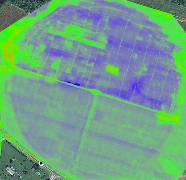
Figure 6. One image is
                                                                                              easily obtained by a UAV
                                                                                              (a). Combining those
                                                                                              images into a mosaic of the
                                                                                              entire field requires each
                                                                                              photo to be marked by a
                                                                                              GPS and sophisticated
                                                                                              software to stitch them
                                                                                              together. Without the
                                                                                              software, roads and field
                                                                                              boundaries may not line up
                                                                                              (b)

 easily take one photo of an entire field. For a 40-              Camera Quality will Control how well you can
 acre field (flying below 400 feet), a UAV may need               Combine Overlapping Photos
 to take up to 300 photos to map the entire field.
                                                                  UAVs that are within a farmer’s budget may not
 Like satellite photos, each picture must be                      have the best cameras for creating orthos. High-
 georeferenced (marked with latitude and longitude                quality photogrammetry requires metric cameras
 coordinates). This is why UAVs must be equipped                  that will adjust for distortion in the lens.7 A cheaper,
 with GPS, which can be used to guide the UAV                     off-the-shelf consumer camera may have distortion,
 autonomously over a field as well as geofererence                such as pincushion or barrel (Figure 7).
 each acquired image.
                                                                  Figure 7 shows an example of barrel distortion.
 Images only need GPS coordinates if they are meant               Compared to Figure 7a above, the center of the
 to be overlaid and combined into one whole picture               photo has been curved outward (Figure 7b). For
 of the landscape (Figure 6). These combined                      measuring distance, crop health or creating an
 photographs are called orthomosaics, also called                 ortho, distortion like this would reduce accuracy.
 “ortho” for short. To create an accurate ortho,                  However, if the goal is to simply scout crops or
 images should be overlapped by the UAV, with                     watch for deer, a cheaper camera with distortion
 some recommendations being up to 70%. While this                 would work fine.
 will increase the time required to take photos, it will
                                                                  Another issue to examine when purchasing a
 increase the accuracy of the ortho.
                                                                  camera is the dynamic range. If the landscape or
 It is also recommended to have ground truthing                   time of day has a large range in brightness (dynamic
 points. These can be markers placed in a field that              range), a cheaper camera may not be able to
 are previously georeferenced. They can be checked                discern the difference.7
 in each image to be sure the GPS unit referenced
 each photo correctly.

For more information on this and other topics visit the University of Maryland Extension website at www.extension.umd.edu    4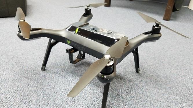
Figure 7. A regular image of a wheat field (a)                  These costs should be weighed against acreage and
  and one with barrel distortion altering the                     accuracy.
  center of the photo (b)
                                                                  Research Is Still Needed on Image Analysis for
                                                                  Plant Health

                                                                  It needs to be emphasized that the actual economic
                                                                  benefits of data collection with UAV’s is still
                                                                  unknown. The quality of the information and the
                                                                  accuracy of the analyses still needs research.

                                                                  For some operations, outside of scouting for pests
                                                                  and damage, detailed analyses may provide little
                                                                  benefit. Paying for services at this time may not be
                                                                  advantageous.

                                                                  NDVI is a good measure of plant health, and UAVs
                                                                  could map problem regions prior to side-dressing
                                                                  nitrogen. For Maryland, this may have to fit into the
                                                                  nutrient management regulatory framework.5,6,8

                                                                  Stand counts have been a successful use of UAVs,
                                                                  since software can be programmed to recognize
                                                                  plant reflectance compared to bare soil.

                                                                  Crop health is more difficult, as NDVI may recognize
                                                                  poor crop health, but not pinpoint whether it is
 Data Storage and Analysis is Another Hurdle for                  caused by disease, nutrient deficiency or saturated
 Individual Producers

 Learning how to fly a UAV is relatively easy                     Figure 8. An aerial image converted to NDVI still
 compared to storing and analyzing data. A 90-acre                has to be interpreted to be useful
 field may take 30 minutes of flight time to collect
 302 photos, but this will also require about 2 GB of
 data. This will require a lot of storage space for
 large farms or agribusinesses.

 Creating an ortho of the field also requires
 computing power and specialized software. Some of
 the most popular versions can be $3,500 to $8,000.

 Another option is to upload photos to the internet
 to be processed in the cloud. Some companies and
 universities are creating algorithms to build orthos
 and analyze crop health for a pay-as-you-go fee.

For more information on this and other topics visit the University of Maryland Extension website at www.extension.umd.edu   5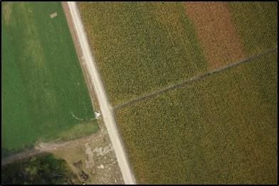
soils.8 Data collection can be relatively easy (Figure                                              2. Zhang, C and J.M. Kovacs. 2012. “The application
 8), but interpretation will take many years of                                                      of small unmanned aerial systems for precision
 research and analyses.                                                                              agriculture: a review,” Precision Agric. 13:693-712.

 Regulations to Operate UAVs Still Being Developed                                                   3. Hunt, E.R., C.S.T. Daughtry, S.B. Mirsky and W. D.
                                                                                                     Hively. 2014. “Remote sensing with simulated
 Anyone can fly a UAV as a hobby or for fun, but
                                                                                                     unmanned aircraft imagery for precision agriculture
 crop scouting is considered a commercial
                                                                                                     applications,” Selected Topics Appl Earth Obs and
 application and requires a remote pilot certificate.
                                                                                                     Remote Sensing. 10: 1-6.
 To become a remote pilot, an individual must pass
                                                                                                     4. Khot, L.R., Q. Zhang, M. Karkee, S. Snakaran and
 an aeronautical knowledge exam, be 16 years old
                                                                                                     K. Lewis. 2016. Unmanned Aerial Systems in
 and vetted by the transportation security
                                                                                                     Agriculture: Part 1 (Systems). UAS in Ag Series.
 administration. All hobby or model aircraft users
                                                                                                     Washington State Extension. FS-194E.
 must be at least 13 years old.
                                                                                                     5. Price, R. 2016. Unmanned Aircraft in Agriculture
 For commercial applications, UAVs must be flown
                                                                                                     [Video]. Unmanned Aircraft Systems in Agriculture
 during the day and kept under 400 feet within the
                                                                                                     Learning Network. Feb 22, 2016. Retrieved from:
 pilot’s line of sight. Class G airspace is okay to fly in,
                                                                                                     https://www.youtube.com/watch?v=gGFlLqPBP1Y
 but all UAVs must be at least five miles from an
 airport. Direct permission is needed for airspace                                                   6. McCornack, B. and K Carraway. 2015. What You
 under air traffic control. The Federal Aviation                                                     Should Know About Small Unmanned Aircraft
 Administration (FAA) has released an app called                                                     Systems (UAS). Kansas State Extension. MF3245.
 B4UFly that informs UAV pilots of any prohibited
 airspace in the area.                                                                               7. Tully, M. 2016. UAS Mapping Basics [Video].
                                                                                                     Unmanned Aircraft Systems in Agriculture Learning
 There are more restrictions than have been listed in                                                Network. Jan. 6, 2016. Retrieved from:
 this publication. To keep up with current                                                           https://www.youtube.com/watch?v=cskFmzXRtfg
 regulations and out of trouble, please see the
 Federal Aviation Administration’s website at                                                        8. Nowatzki, J. 2016. UAS in Agricultural Research
 https://www.faa.gov/uas/                                                                            [Video]. Unmanned Aircraft Systems in Agriculture
                                                                                                     Learning Network. Jan. 6, 2016. Retrieved from:
 References                                                                                          https://www.youtube.com/watch?v=ZtFuwJ60NfA

 1. Ehmke, T. 2013. “Unmanned aerial systems for
 field scouting and spraying,” CSA News. December.
 Madison, WI.

 This publication, Providing Aerial Images through UAVs (FS-1056), is a series of publications of the University of Maryland Extension
 and Plant Science and Landscape Architecture. The information presented has met UME peer review standards, including internal and
 external technical review. For more information on related publications and programs, visit: https://extension.umd.edu/grain/precision-
 agriculture. Please visit http://extension.umd.edu/ to find out more about Extension programs in Maryland.

 The University of Maryland, College of Agriculture and Natural Resources programs are open to all and will not discriminate against anyone because of race, age, sex, color,
 sexual orientation, physical or mental disability, religion, ancestry, or national origin, marital status, genetic information, or political affiliation, or gender identity and expression.

For more information on this and other topics visit the University of Maryland Extension website at www.extension.umd.edu                                                                       6
You can also read


