DESIGN AND CONSTRUCTION OF AN AVALANCHE DEFLECTING BERM, MOUNT KITCHENER AVALANCHE PATH, AORAKI MOUNT COOK NATIONAL PARK, NEW ZEALAND
←
→
Page content transcription
If your browser does not render page correctly, please read the page content below
Proceedings, International Snow Science Workshop, Innsbruck, Austria, 2018
DESIGN AND CONSTRUCTION OF AN AVALANCHE DEFLECTING BERM, MOUNT
KITCHENER AVALANCHE PATH, AORAKI MOUNT COOK NATIONAL PARK, NEW
ZEALAND
Alan Jones1*, Donald Bogie2
1
Dynamic Avalanche Consulting Ltd., Revelstoke, BC, Canada
2
Department of Conservation – Te Papa Atawhai, Christchurch, New Zealand
ABSTRACT: The Mount Kitchener avalanche path produces large avalanches that have potential to affect
parts of Aoraki Mount Cook Village, New Zealand. Numerous buildings located in the runout zone could be
affected by avalanches, including the iconic Hermitage Hotel and several residences. Although there is no
historical evidence of destructive avalanches reaching the village, statistical and dynamic avalanche modelling
combined with field evidence confirmed the potential for Destructive Size 4 or 5 avalanches to reach the village
with a return period between 100 and 300 years. The potential runout position of the dense component of 100
to 300-year avalanches was determined to be within the limits of the village. Powder avalanches could pene-
trate further into the village, as has been evidenced by historical events. Potential impact pressures within the
village were estimated in the range of 1 to 70 kPa. The existing 2 m high deflection berm constructed on the
debris fan has been overtopped on numerous occasions and was determined to be ineffective in reducing risk
to acceptable levels. Construction of an improved berm was proposed to reduce the potential magnitude and
frequency of avalanches reaching the village, and thus reduce risk to people and infrastructure. Construction
of the berm was completed in two phases, with initial construction during 2015-2016, and a final phase of
construction completed in April 2018. The completed earth fill berm is 305 m long, with a height varying from
3.5 to 10 m. The historical context and importance of this avalanche path is discussed, including description
of the evaluation and design process for the deflection berm, and a summary of the challenge of constructing
this berm within a heavily visited and environmentally sensitive national park.
KEYWORDS: Avalanche risk, hazard mapping, runout, dynamic model
important infrastructure and permanent populations
1. INTRODUCTION in the village.
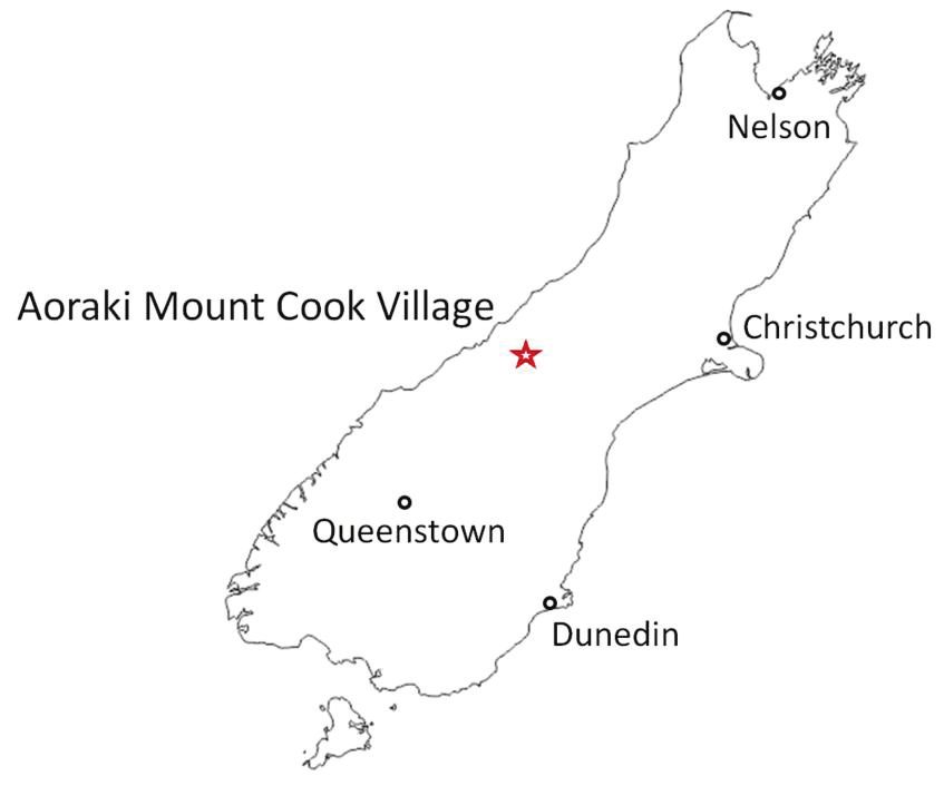
The Mount Kitchener avalanche path is located adja- A variety of mitigation options were evaluated to re-
cent to the Aoraki Mount Cook Village, on the South duce risk to structures and the public in the village,
Island of New Zealand (Figure 1). This path produces including increasing the height and potential re-align-
large avalanches (i.e. Size D4 or 5) that have the po- ment of the diversion berm; monitoring, evaluation
tential to affect parts of the village, including several and avalanche control; and structural reinforcement
residences and the iconic Hermitage Hotel, which and/or structural protection of buildings (e.g. stopping
has been at this location since 1958. Avalanches with walls, splitters, multi-purpose stopping/diversion
over two hectares (ha) of debris have reached the fan berm). Ultimately, construction of an improved berm
during 1995, 2004 and 2009, and light powder flow with a new alignment and increased height was cho-
has historically reached the village (Fitzharris, 1986; sen, which is discussed in the following sections.
DOC, 2009).
Fitzharris (1986) identified the Kitchener avalanche
path as a potential risk to the village. Geotechnical
investigations completed in 1995 (McSaveney et al.,
1995) and 1996 (McCahon, 1996) also identified the
potential for avalanches to affect the village, in addi-
tion to potential debris flow risk.
A 2 m high diversion berm constructed on the debris
fan in 1958 has been overtopped on numerous occa-
sions and was determined to be ineffective in reduc-
ing risk to acceptable levels given the presence of
* Corresponding author address:
Alan Jones, Dynamic Avalanche Consulting Ltd.,
PO Box 2845, Revelstoke, BC, Canada, V0E2S0
tel: +1 250-837-4466; fax: +1 250-837-4464
email: alan.jones@dynamicavalanche.com Figure 1: Location of Aoraki Mount Cook Village.
197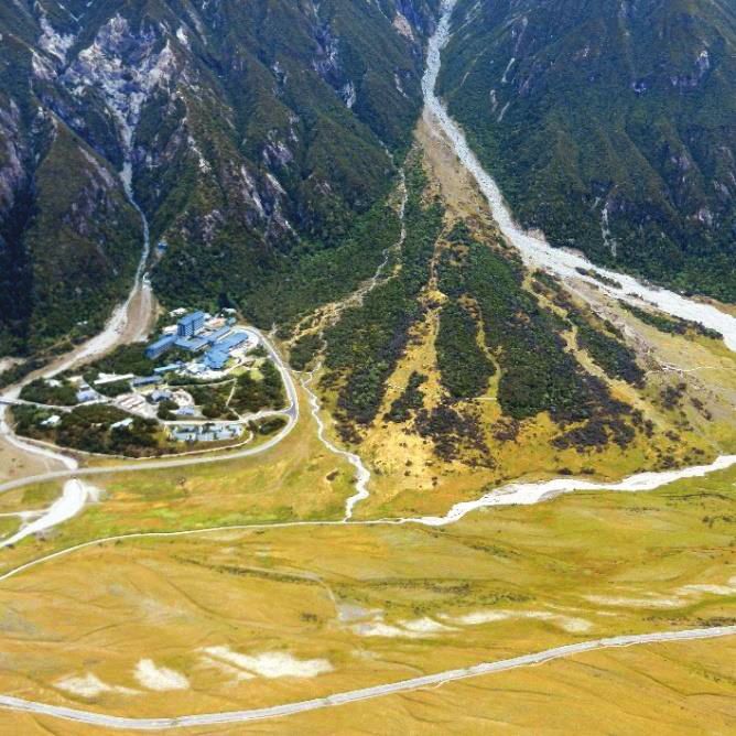
Proceedings, International Snow Science Workshop, Innsbruck, Austria, 2018
2. HAZARD MAPPING AND EVALUATION 2.2 Historical avalanche frequency analysis
Fitzharris (1986) provided an overview of historical
2.1 Avalanche terrain avalanche activity in the Kitchener avalanche path
The Mt. Kitchener avalanche path is a large, east- (Figure 3 and Table 1). Additional observation of
facing path with a vertical fall height of 1,340 m. The large avalanches in 2004 and 2009 built up the da-
start zone is a large alpine bowl feature with an area taset so that there were 9 documented Size 3-4 ava-
of approximately 6 ha and average slope angle of lanche events in this path during 1965 to 2009 (45
29°. The track is a confined gully which is approxi- years), or an average return period of 5 years for av-
mately 700 m long and has an average slope angle alanches reaching below the upper fan (i.e. 960 m
of 30°. The runout zone is a large 40 ha fan with sev- elevation). From this data, it was possible to con-
eral stream courses. The south side of the runout is clude that the 1986 event had a nominal return period
heavily vegetated with older Totara forest (Figure 2). of 50 years. By plotting these runout estimates on a
semi-log graph of horizontal runout distance (i.e. total
Due to presence of a diversion berm which was orig- horizontal distance measured from the top of the
inally constructed in 1958, the predominant flow di- starting zone) versus Return Period, a good relation-
rection of avalanches and debris flows is towards the ship was developed that could be used to project
north of the runout, which is therefore less vegetated runout to 100 years, and possibly longer (Figure 4).
and covered in course debris. The main creek drain-
age flows along the north extent of the runout zone.
Aoraki Mount Cook Village is in the extreme runout
position on the far south side of the runout zone. The
average slope angle of the runout zone at the upper-
most edge of the village is 7 degrees, but slope an-
gles in the runout zone vary between 0° (upper road
bench) and approximately 12°.
The largest observed avalanche from the Mt. Kitche-
ner path occurred in 1986. Fitzharris (1986) de-
scribed the event as “a typical mixed-motion event
that included a dense layer of flowing snow near the
ground, and a large airborne powder cloud that sub-
sequently drifted over the Mt Cook Village”. This
event was the largest to have occurred since 1968.
Local experts estimated that this path is capable of
producing a Size D5 avalanche (DOC, 2009), which
although it hasn’t been observed to date is certainly
possible given the large scale of the path and deep
winter snowpack in the extensive starting zone. Figure 3: Reproduction of Figure 6 from Fitzharris
(1986) with highlighted historical avalanche outlines
and avalanche hazard lines (50 and 100-year lines).
Table 1: Estimated return period of historical ava-
lanches in Kitchener Path, 1965-2009
Eleva-
Horizontal Approx. Nominal
tion of
Runout Return Return
Year toe of
Distance Period Period
deposit
(m) (years) (years)
(m)
1984 960 1727 5 ~
1980 930 1823 6 ~
1965 910 1909 6 5
1972 880 2037 8 ~
1982 870 2058 9 ~
1995 850 2122 11 10
2009 840 2154 15 15
2004 810 2258 23 30
1986 785 2339 45 50
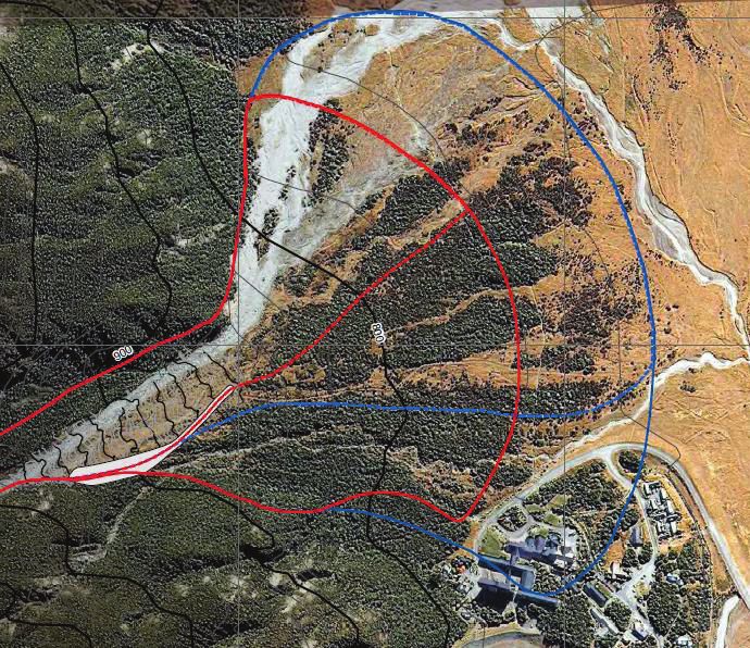
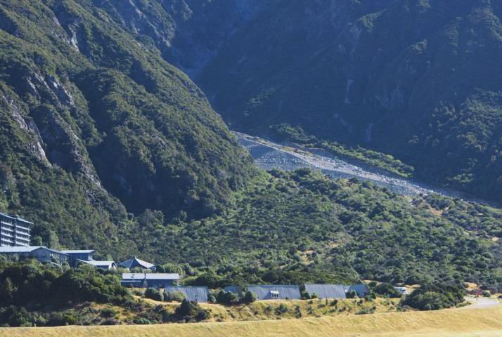
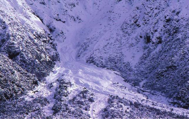
Figure 2: Debris fan on the Mount Kitchener ava-
lanche path, with Aoraki Mount Cook Village on left.
198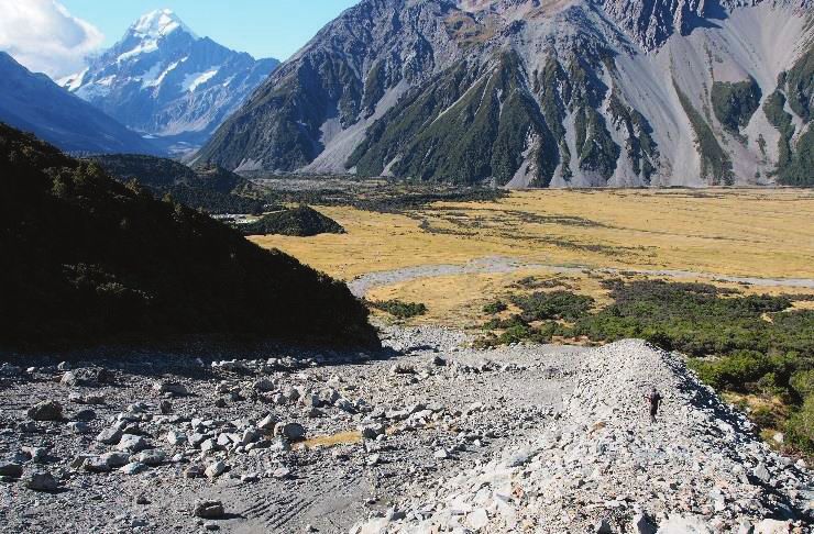
Proceedings, International Snow Science Workshop, Innsbruck, Austria, 2018

                                                                  3. DESIGN OF THE DIVERSION BERM
                                                                  Investigations and historical observations of ava-
                                                                  lanches in the path led to the conclusion that the ex-
                                                                  isting 2 m high berm was only effective for relatively
                                                                  small avalanches and could be easily overtopped by
                                                                  larger (Size D3 or D4) avalanches. This is illustrated
                                                                  by events in 1995 (Figure 5) and 2009 (Figure 6).

Figure 4: Runout distance of historical avalanches in
the Kitchener avalanche path during 1965-2009, with
a logarithmic fit of runout distance as a function of
return period (R² = 0.99).
The 1986 avalanche was the longest running histori-
cal event in this path, but it did not reach the 10° β-
Point. This is typical in avalanche terrain where the
runout zones are normally free of snow or have a
shallow snowpack and rough terrain. Bare ground
causes avalanches to start slowing down on steeper
slopes (e.g. 15-20°) rather than continue on inclines
less than 10°.                                                    Figure 5: Avalanche debris onto the Kitchener fan in
It was observed that annual events reach the bottom               1995. Debris covered approximately 2.7 ha with
of the gully, which is coincident with the typical winter         70,000-90,000 m3 of debris, some of which over-
snowline for this path; avalanches with 10 to 50-year             topped the original diversion berm.
return periods stop above the β-point and are not ex-
pected to affect the village. The 100-year avalanche
is expected to stop just above the loop road (road is
visible around the village in Figure 2), which was con-
sistent with the Fitzharris (1986) 100-year hazard line
(Figure 3). 300-year events were interpreted to be
capable of reaching Aoraki Mt Cook Village, poten-
tially affecting permanently occupied structures.

2.3 Avalanche hazard evaluation
Although there is no historical evidence of destructive
avalanches reaching the village, statistical and dy-
namic avalanche modelling combined with field evi-
dence confirmed the potential for Destructive Size 4
or 5 avalanches to reach the village with a return pe-
riod between 100 and 300 years, which indicated the
village was within the Blue hazard zone. The poten-
tial runout position of the dense component of 100 to
300-year avalanches was determined to be within the               Figure 6: Avalanche in the Kitchener path, 24 July,
limits of the village. Powder avalanches could pene-              2009. Dashed blue line delineates approximate toe
trate further into the village, as has been evidenced             of deposit which overtopped the diversion berm
by historical events (e.g. Fitzharris, 1986). Potential           (DOC photo).
impact pressures within the village were estimated in             Another deficiency with the existing berm was that it
the range of 1 to 70 kPa, depending on the location               did not start high enough on the slope to prevent
within the village.                                               overtopping at the top of the berm. It was also not
The existing 2 m high deflection berm constructed on              aligned sufficiently oblique to the main flow direction
the debris fan has been overtopped on numerous oc-                to deflect avalanches without excessive overtopping.
casions and was determined to be ineffective in re-               Due to these factors, construction of a new berm (lo-
ducing risk to acceptable levels. Construction of an              cation and geometry) was recommended, rather than
improved berm was proposed to reduce the potential                improvement of the existing berm.
magnitude and frequency of avalanches reaching the                The improved berm was designed to mitigate the
village, and thus reduce risk to people and infrastruc-           100-year design dense-flowing avalanche, which
ture.                                                             would reduce risk to the village to acceptable limits.

                                                            199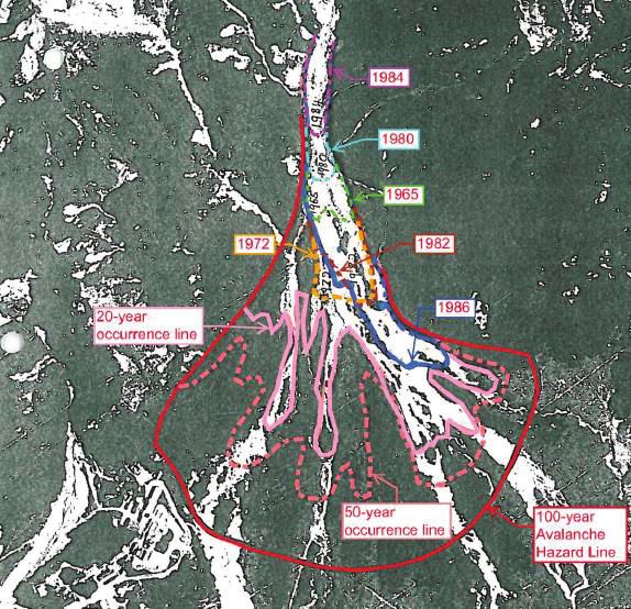
Proceedings, International Snow Science Workshop, Innsbruck, Austria, 2018

                                                                  With the diversion berm, the Red/Blue hazard line
                                                                  (which includes more frequent, dense flow ava-
                                                                  lanches) will follow the crest of the diversion berm
                                                                  (Figure 7). The berm will direct most avalanches
                                                                  down the main stream channel and away from the
                                                                  village. Once avalanches reach the lower end of the
                                                                  berm they can turn towards the village, but the terrain
                                                                  will direct flow down the topographic fall line. The
                                                                  Blue hazard line was revised to show the diversion
                                                                  berm directing most flow down the fall line into the
                                                                  main stream channel, but with some dense and pow-
                                                                  der flow expected to overtop the lower part of the
                                                                  berm where it drops to a height of 3.5 m. However,
                                                                  by that point flow will be directed downstream and not
                                                                  be able to turn back towards the village. The revised
                                                                  hazard zoning resulted in a reduction in risk such that
                                                                  avalanches would not affect the upper loop road or
                                                                  the village, thus achieving the project goal.

                                                                  4. CONSTRUCTION
                                                                  Construction of the improved diversion berm was
Figure 7: Avalanche hazard zones (Red and Blue) for               completed in two phases, first during 2015-2016, and
the Kitchener path with (inside lines) and without                a second phase completed in April 2018.
(outer red and blue lines) the improved diversion
berm. The berm (outlined in white in the upper fan)               The first phase was intended to include the full com-
moves the Blue line outside of the village area.                  pletion of the berm. When the post construction sur-
                                                                  vey was undertaken in 2016, it was discovered that
The berm was designed to accommodate an ava-                      the berm was one metre lower than its design height
lanche with a velocity of 35 m/s at the upper intersec-           and that the total volume of material moved was less
tion with the berm, with a flow height of 2.5 m. The              than the construction company had claimed had
angle of incidence was 19 degrees based on the as-                been moved. As the contract was based on cubic me-
sumption that an avalanche banks from the north                   tres of material moved, this affected the cost of the
side of the gully before it impacts the berm. A rela-             project. The effectiveness of the shorter berm was
tively thin snowpack of 1 m was estimated to be pre-              evaluated to determine if it would provide sufficient
sent, which reflects long-term snowpack height data.              protection. After re-analysis of a design avalanche,
Because re-contouring of the slope was planned ad-                the decision was made that the berm needed to be
jacent to the berm, it was assumed that no previous               brought up to design height to provide the required
deposit would be present behind the berm. Additional              amount of protection to the village. After nearly two
snow storage capacity was created in front of the                 years of protracted negotiations, a re-measure by the
berm to allow avalanches to spread laterally within               contractor, and the invoking of the arbitration clause
the catchment area of the berm.                                   in the contract, the contractor returned and com-
The design berm had a height of 10 m at the upper                 pleted the berm to the original design height in 2018.
end, tapering down to 3.5 m at the lower end where                As the Kitchener path is within Aoraki Mount Cook
it acts as a guiding berm rather than a diversion. The            National Park, it was necessary to complete an as-
berm was designed with a 1.5 horizontal to 1.0 verti-             sessment of environmental impacts prior to gaining
cal (1.5H:1V) fill slope on both sides, with a 3 m crest.         approval for the work. As the site of the proposed
Avalanche hazard zone mapping determined that the                 works was in the village amenities area, the park
Blue Zone extends approximately 150 m from the up-                management plan permitted the construction of pro-
per loop road into the Village. This represents poten-            tective structures.
tial avalanche risk from low frequency powder ava-                Being a heavily disturbed avalanche path also sub-
lanche impact pressures that exceed 1 kPa and with                ject to debris flows, there were no threatened plant
a return period of less than 300 years. Dense flowing             species or mature forest growing on the footprint of
avalanches were not expected to flow past the upper               the berm. The area has a population of native skinks
loop road, but rather stop on the slope upslope of the            and geckos that were relocated to another suitable
northwest edge of the road. The Red/Blue hazard                   habitat. From a visual perspective a curved rock wall
line was interpreted to be located approximately                  was not out of place with the natural and artificial fea-
30 m upslope of the upper loop road.                              tures in the vicinity of the works. There were already
                                                                  several protective berms in the village providing pro-
                                                                  tection from debris flows and the finished berm was

                                                            200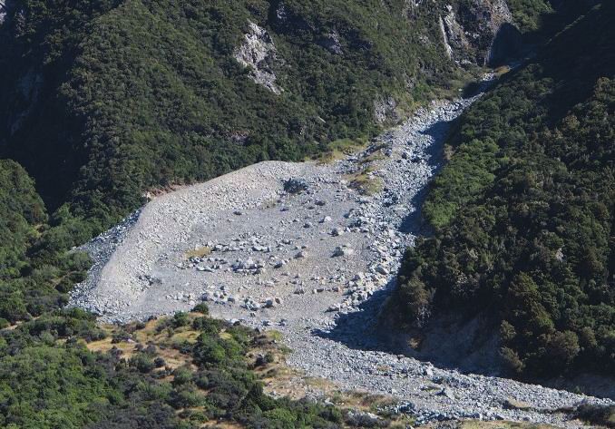
Proceedings, International Snow Science Workshop, Innsbruck, Austria, 2018
not to unlike a natural moraine wall. On the advice of
the landscape architect for the project, the length of
the berm was shortened slightly and the side of the
berm facing the village was left rough by scattering
moderate sized boulders on its surface.
Figure 11: Completed diversion berm viewed from
Aoraki Mt. Cook Village.
5. CONCLUSION
The Mount Kitchener avalanche path produces large
avalanches that have potential to affect parts of Ao-
raki Mount Cook Village, New Zealand. Numerous
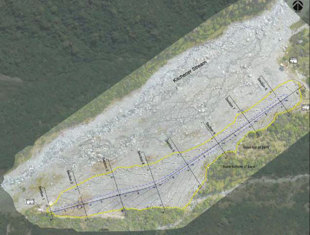
Figure 8: As-built diversion berm in plan view.
buildings located in the runout zone could be affected
The final cost of the project was NZ $700,000 by avalanches, including the iconic Hermitage Hotel
(€430,000). An as-built survey was completed, which and several residences. Statistical and dynamic ava-
showed the final constructed fill to be 46,369 m3, with lanche modelling combined with field evidence con-
construction as per the original design concept (Fig- firmed the potential for Destructive Size 4 or 5 ava-
ure 8). Figures 9 through 11 show three views of the lanches to reach the village with a return period of
completed structure. 100 and 300 years.
The 2 m high deflection berm constructed on the de-
bris fan had been overtopped on numerous occa-
sions and was determined to be ineffective in reduc-
ing risk to acceptable levels.
An improved berm was constructed during 2015-16,
with a second final phase of construction completed
in April 2018. The completed berm is 305 m long, with
a height varying from 10 m at the upper end to 3.5 m
in the lower end where it serves as a guiding berm.
This berm will reduce the potential magnitude and
frequency of avalanches reaching the village, and
thus reduce risk to people and infrastructure.
Figure 9: Completed diversion berm looking
downslope. ACKNOWLEDGEMENTS
Thanks are provided to Ryan Buhler for reviewing
this paper and very helpful feedback and discussion.
REFERENCES
Department of Conservation (DOC), 2009. Report on the Kitche-
ner Avalanche Path Aoraki Mount Cook Village. Department
of Conservation, Canterbury Conservancy. April 30, 2010.
Fitzharris, B.B., 1986: Report on avalanche behind Hermitage, Mt
Cook, July 1986, Department of Geography Otago University.
McCahon, I., 1996. Report for Department of Conservation by
Royds Consulting, Geotechnical Report No 2 Mount Cook/Ao-
raki Village.
McSaveney, M.J., T.R.H. Davies, J.D. Gough, 1995. Natural haz-
ard assessment for Mount Cook / Aoraki Village and environs.
Report prepared by Institute for Geological and Nuclear Sci-
Figure 10: Completed diversion berm. ences Limited. December 1995.
201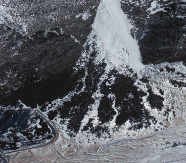
You can also read