QUANTIFYING WATER RECHARGE AND WATER USE IN HAND DUG WELLS: A CASE STUDY OF THIAWOR, SENEGAL, WEST AFRICA
←
→
Page content transcription
If your browser does not render page correctly, please read the page content below
Michigan Technological University
                                                      Digital Commons @ Michigan Tech

Dissertations, Master's Theses and Master's Reports

2020

QUANTIFYING WATER RECHARGE AND WATER USE IN HAND
DUG WELLS: A CASE STUDY OF THIAWOR, SENEGAL, WEST
AFRICA
Celine Carus
Michigan Technological University, cmcarus@mtu.edu

Copyright 2020 Celine Carus

Recommended Citation
Carus, Celine, "QUANTIFYING WATER RECHARGE AND WATER USE IN HAND DUG WELLS: A CASE STUDY
OF THIAWOR, SENEGAL, WEST AFRICA", Open Access Master's Report, Michigan Technological
University, 2020.
https://digitalcommons.mtu.edu/etdr/1024

Follow this and additional works at: https://digitalcommons.mtu.edu/etdr
   Part of the African Languages and Societies Commons, Geology Commons, Social and Cultural Anthropology
Commons, and the Water Resource Management Commons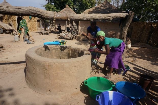
QUANTIFYING WATER RECHARGE AND WATER USE
IN HAND DUG WELLS: A CASE STUDY OF THIAWOR,
           SENEGAL, WEST AFRICA

                                   A REPORT

       Submitted in partial fulfillment of the requirements for the degree of

                             MASTER OF SCIENCE

                                    In Geology

                MICHIGAN TECHNOLOGICAL UNIVERSITY

                                       2020

                               © 2020 Celine Carus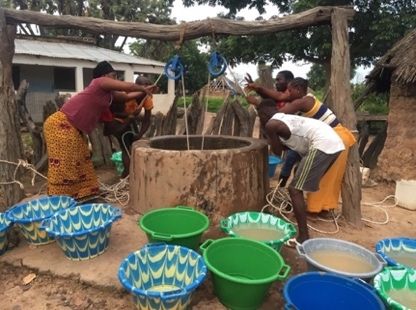
This report has been approved in partial fulfillment of the requirements for the Degree of
MASTER OF SCIENCE in Geology.

                                 Department of Geological and Mining Engineering and Sciences

             Report Co-Advisor:      John S. Gierke

             Report Co-Advisor:      Kari Henquinet

            Committee Member:        David Watkins

              Department Chair:      Aleksey Smirnov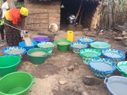
TABLE OF CONTENTS
LIST OF FIGURES ..................................................................................................................................................... 4
LIST OF TABLES ....................................................................................................................................................... 5
ACKNOWLEDGEMENTS ......................................................................................................................................... 6
ABSTRACT .................................................................................................................................................................. 7
STUDY MOTIVATION & OBJECTIVES................................................................................................................ 9
SENEGAL: AN OVERVIEW ..................................................................................................................................... 9
    RAINFALL TRENDS IN SENEGAL ............................................................................................................................... 10
    GEOLOGY AND HYDROGEOLOGY OF SENEGAL ........................................................................................................ 11
SITE LOCATION ...................................................................................................................................................... 11
    VILLAGE SETTING .................................................................................................................................................... 12
    VILLAGE WELLS ...................................................................................................................................................... 13
METHODS AND FIELDWORK ............................................................................................................................. 14
    PUMPING TESTS........................................................................................................................................................ 14
    INTERVIEW METHODS .............................................................................................................................................. 17
RESULTS .................................................................................................................................................................... 19
    INTERVIEW DATA ANALYSIS.................................................................................................................................... 19
    PUMPING TEST RESULTS AND DATA ANALYSIS USING AQTESOLV ...................................................................... 25
DISCUSSION ............................................................................................................................................................. 34
    PUMPING TEST AND ANALYSIS DISCUSSION ............................................................................................................ 34
    INTERVIEWS DISCUSSION ......................................................................................................................................... 35
FUTURE WORK & RECOMMENDATIONS ....................................................................................................... 37
CONCLUSIONS......................................................................................................................................................... 37
WORKS CITED ......................................................................................................................................................... 39

                                                                                      3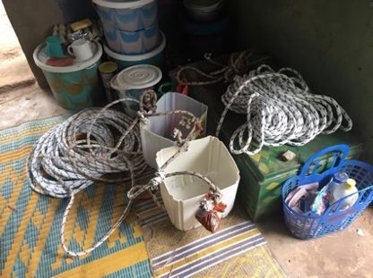
List of Figures
Figure 1: A compound well in Thiawor........................................................................................ 13
Figure 2: Constructed measurement tape with hollow container to make a sound when reaching
the water level. .............................................................................................................................. 14
Figure 3: View down a compound well ........................................................................................ 15
Figure 4: Two teams performing the pump tests at one of the village wells ................................ 15
Figure 5: Materials used to pump water from the wells ............................................................... 15
Figure 6: Pouring the pumped water into laundry buckets for measurement ............................... 16
Figure 7: Afternoon water retrieval using the traditional pulley method ..................................... 22
Figure 8: Diawara Well recovery phase of pumping test. Data fit with AQTESOLV to match
parameters to the Moench (1997) solution, which accounts for pumping and recovery in a
partially penetrating well with wellbore storage in a homogeneous, isotropic, unconfined aquifer.
....................................................................................................................................................... 28
Figure 9: Camara Well recovery phase of pumping test. Data fit with AQTESOLV to match
parameters to the Moench (1997) solution, which accounts for pumping and recovery in a
partially penetrating well with wellbore storage in a homogeneous, isotropic, unconfined aquifer.
....................................................................................................................................................... 29
Figure 10: Sankare Well recovery phase of pumping test. Data fit with AQTESOLV to match
parameters to the Moench (1997) solution, which accounts for pumping and recovery in a
partially penetrating well with wellbore storage in a homogeneous, isotropic, unconfined aquifer.
....................................................................................................................................................... 30
Figure 11: Danfakha Well recovery phase of pumping test. Data fit with AQTESOLV to match
parameters to the Moench (1997) solution, which accounts for pumping and recovery in a
partially penetrating well with wellbore storage in a homogeneous, isotropic, unconfined aquifer.
....................................................................................................................................................... 31
Figure 12: Sunkaro Well recovery phase of pumping test. Data fit with AQTESOLV to match
parameters to the Moench (1997) solution, which accounts for pumping and recovery in a
partially penetrating well with wellbore storage in a homogeneous, isotropic, unconfined aquifer.
....................................................................................................................................................... 32

                                                                            4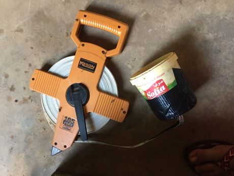
List of Tables
Table 1.1 Pumping Test Data for each Well ................................................................................. 17
Table 2.1 Parameter values of each well derived from Moench (1997) solution ......................... 27
Table 3.1 Percent drawdown and estimated percent maximum yield of wells ............................. 33

                                                              5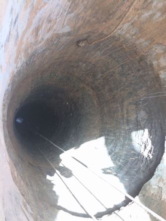
Acknowledgements
I would first and foremost like to thank the entire community of Thiawor for enthusiastically and kindly
welcoming me, a stranger to them, to share their lives and work with me. To my host family the Diawara,
I have unending gratitude for the compassion, care, and understanding they showed me for two years as
they helped me learn language, customs, and culture. My time in Senegal would have been very different
without these relationships. Additionally, without the constant support of fellow volunteers and Peace
Corps Senegal staff I would have never had as fulfilling and productive a service. Thank you to the
volunteers who transported materials to and from the United States for me on their personal trips, as well
as to those who stayed with me for motivational and research support; there are more than I could name. I
would like to give special thanks to the Michigan Technological University professors Dr. Kari
Henquinet, Dr. John Gierke, Dr. Watkins, and Dr. Blair Orr, for a multitude of reasons. Firstly, for their
active support in helping develop my research, but more importantly for their personal care, empathy and
understanding of the difficulties of international research and life. The responsive conversations
concerning both research and everyday struggles mean more to me than I can adequately express. I thank
my parents and personal friends for allowing me to share my experiences with them during their brief
visits to Senegal – I know it also meant a lot to my community to have two parts of my life meet. To the
larger Michigan Tech PCMI community; you offered me support and advice before, during, and after my
service that prepared me and carried me through.

                                                    6
Abstract
For many rural communities in Senegal, water is an essential life-giving need received only
through a network of hand dug wells. Increasing rainfall variability in the Sahel has driven
greater water insecurity for those communities that rely on rain-irrigated systems for agriculture.
This study investigates the retrieval, purposes, and quantities of seasonal water usage on a small
domestic scale, as well as an analysis of perceived water availability in the wells during the rainy
season. Additionally, using a combination of interview data and pumping test data obtained from
the village wells, water usage and estimated daily needs are calculated and compared to potential
well productivity. The analyses of the community water needs from the surveys and capabilities
of the wells to produce water confirm that the wells not only provide the current needs but
improved pumping and/or well configurations could provide approximately 10 times the current
usage.
7Introduction
For much of the planet, water quality and water access are an increasingly important issue. In arid
environments like the West African Sahel, average precipitation has been declining during the past
century (Dietz et al., 2004) (Sissokho et al., 2011). The African continent is projected to be especially
vulnerable to climate change, with drastic climatic shifts being reported in the last century, and predicted
to continue (Field et al., 2014). Because of the increasing unpredictability of rainfall events, agricultural
ways of life are at increased risk, and food security and water security for vulnerable populations are at
risk (Verhagen et al., 2004). In a country like Senegal, where 73% of the population is involved in
agricultural production as their primary occupation, this seasonal rainfall variability is of great importance
to livelihoods, health, and economic stability (Serdeczny, 2016).
This study is located in the West African Sahel, which encompasses Senegal, The Gambia,
Guinea-Bissau, Mali, Burkina Faso, Niger, Chad, Mauritania, and Cape Verde (Sissokho et al., 2011).
Populations are growing in these countries, which means that whatever environmental impacts from
climate change are occurring are impacting more people. Studies show that drier agricultural years in this
region contribute to the continuation of cycles of poverty as resources are diminished and scarcer (Ludeke
et al., 2004).
Water levels in wells, especially hand-dug wells, are indicators of drought conditions as the levels
reflect the shallow subsurface water table elevation, which is recharged from infiltration. Many small
villages and communities rely on hand-dug wells as their primary water source for drinking water and
other domestic activities. It is thus important to understand what domestic household use is, especially
when these small villages are accessing groundwater from solely hand dug wells. Changes in water levels
can be an indicator of long-term changes in the future and can provide insight into strategies in the future
of how or what can be done to manage access to water. Water scarcity can be linked to hygiene issues,
economic issues, and a decline in well-being. Small household gardens are a source of nutrition and
income in Senegal; difficulty in providing water to compound gardens can result in economic issues and
gender-equality issues, as women are the primary gardeners and responsible for the majority of water
retrieval for domestic activities.
The evaluation of vulnerability to water scarcity and potential approaches to enhance access to
water supplies requires an understanding of community needs for water and the availability of water from
the local resources. This project was designed to ascertain the current usage of water and the perceived
needs and measure the production capacity of existing wells for satisfying current needs and availability
for future increases in demands. Two types of data were collected to discern water needs and availability:
manual pumping tests and interviews discussing household and domestic garden use on the village-level
in a small village, Thiawor, in Senegal, West Africa. The purpose of the project was to distinguish the
purposes and quantity of water available during the rainy season and to see if it meets the village demands
currently, and how the village perceives local water availability. Recovery data taken from pumping tests
were used to characterize basic hydrologic properties of the aquifer, as well as analyze the effectiveness
of the data collection methods.
This research found that under idealized aquifer conditions in the rainy season, the wells in
Thiawor provide between 49-72 liters per minute, assuming a 100% drawdown of the estimated saturated
depth in the dug wells. The village uses 7,560 liters per day in the rainy season to meet five core domestic
needs. Overall perception of water availability in the village is that during the rainy season their needs are
met. However, while these village needs are met during the rainy season, there are local water issues that
contribute to water insecurity that exceeds availability of water in the well.
8Study Motivation & Objectives
Significant water insecurity in the world is an increasing global concern. Information gathered from
local perspectives is crucial in understanding impacts on vulnerable communities. If anthropologists,
development professionals, and local leaders understand the impacts natural disasters have on communities,
then they can better develop and implement strategies for mitigation and prevention including future
planning for at-risk communities.
The selection for this case study location was based partially on the geographic location of the
author during her Peace Corps service as an Agroforestry volunteer and her relationship with the
community. Additionally, this location was determined to be an appropriate location for a study due to
local population vulnerability and exposure to domestic water issues. This case study elaborates on water
use in rural villages that do not have access to governmental infrastructure projects like solar pumps or
running water. The purpose of this paper is to understand if water availabilitat the village level currently
meets domestic needs seasonally. The report assesses the volume and allocation of water used daily in
each household. Pumping tests were performed to characterize the production capacity for shallow
groundwater resources.
In addition to pumping tests, oral interviews were conducted about domestic water use in a small
rural village setting. The interviews were comprised of questions to the community about domestic water
quantity use, and how much is allocated to each purpose. Average household consumption is quantified
from these interviews, and peak water recharge in five productive village wells is measured, concluding
with discussions of seasonal water demand and implications for the future. The information gathered
seeks to discern impacts on vulnerable communities. Increased understanding of localized water resources
in a community allows for more informed development and implementation of strategies of mitigation.
Senegal: An Overview
The Republic of Senegal is a country located in the westernmost portion of Africa, situated to the
south of Mauritania and north of Guinea Bissau and Guinea, and bordered by the Atlantic Ocean to the
west. The country is separated into 14 governmental regions and hosts large ethnic diversity. The country
population is estimated at 15.7 million (The World Factbook, 2020). The official languages of Senegal are
French and Wolof, although many different languages and ethnic groups are present. As of a 2018
estimate, annual population growth is at a rapid 2.8% (The World Bank, 2019), and more than 60% of the
population is under the age of 25 (The World Factbook, 2020). Rapid population growth and increased
demand for resources could have important climate and water implications in the future.
Roughly 52% of the population is rural (The World Bank, 2019), with 46.8% of land available for
agriculture (The World Factbook, 2020), and 42.8% forested (2016 estimate) (The World Bank, 2019).
More than 77% of the population is involved in some sort of agriculture activity (2007 estimate) (The
World Factbook, 2020). As of last estimate in 2011, 47% of the population is below the poverty line (The
World Bank, 2019), and the unemployment rate is 6.7% (2016 estimate) (International Labour
Organization, 2020) (The World Factbook, 2020). There are many diverse ethnic groups and languages
present in Senegal. Major agricultural products include: peanuts, millet, corn, sorghum, rice, cotton,
tomatoes, green vegetables; cattle, poultry, pigs and fish (The World Bank, 2019). Agriculture is
primarily rain-fed subsistence farming.
The terrain in Senegal is generally low, flat, rolling plains, with foothills toward the southeast
region of Kedougou, and has a mean elevation of only 69 meters above sea level. Senegal has three
climate regions within the Köppen-Geiger climate classification: warm desert, warm semi-arid, and
tropical savannah. Senegal is part of a transitional zone that stretches from a more humid southern zone to
the south and a drier Saharan desert climate to the north. Additional coastal and continental wind field
processes (the Azores anticyclone, the North African Anticyclone, the Saharan thermal low and the Saint
Helena anticyclone) influence the climate as well, leading to two prominent seasons of dry and wet
9(Ndione et al., 2017a). In Senegal-Oriental, where Thiawor is located, the rainy season is between June to
October, and dry season is roughly from November to May.
The Sahelian region is semi-arid. Daytime temperatures can reach 40 °C, but nightly temperatures
can drop to around 14 °C. Annual average rainfall is around 300-400 mm, but fall between extremes, as
rainfall usually occurs in fewer than 30 days of the year between the months of June and September.
Nomadic pastoralists are common in this area, grazing their flocks of cattle, goats, and sheep. In the more
southern part of the Sahel, the soil is sandy and is well known as the Peanut Basin; peanut (or groundnut)
is one of the most important crops in Senegal. The more northern parts of the Sahel often grow sorghum
and have a similar climatic condition as neighboring Saharan countries Mali and Mauritania. The
Southern regions of Kolda and Kedougou are hotter and humid, and average daily temperatures are above
30°C throughout the year. Rainfall is more frequent, at around 1000-1500 mm annually in the
southernmost region. Here the rainy season lasts 2 to 3 months and extends into October. Agriculture is
quite common in this region growing millet, maize, sorghum, rice, cassava, beans, sweet potatoes, and
varieties of fruits. Tambacounda lies between the north and the south and is where the study site is
located; it is the largest governmental region and comprises two of these climate regions - warm semi-arid
to the north, and tropical savanna climate to the south. The study area, Thiawor, is in a transition zone
between these two regions, with less frequent rainfall than the southern regions, and where many
agricultural communities and semi-nomadic pastoralists coexist. There are 15 identified ecoregions within
Senegal (Tappan et al., 2004). The country suffers from periodic droughts (The World Factbook, 2020).
More than 3 million Senegalese (including those of the case study area) lack basic access to
water, defined as potable water that is from an improved source, provided collection time is not more than
30 minutes for a round trip, including wait time. This includes 'safety managed' water, which refers to
drinking water from an improved water source that is located on premises, readily available when needed,
and free of fecal and chemical contamination. More than 16% of the Senegalese population receives water
from an unimproved water source; i.e. directly from a hand-dug well or spring without any sort of
filtering or management, as is the case of Thiawor (UNICEF & World Health Organization, 2012).
Rainfall Trends in Senegal
Rainfall patterns are variable in the Sahel, creating difficulty predicting potential impacts of water
recharge, especially on a small local scale. Historically, Senegal has experienced significant drought
periods. From 1950 to the mid 1980s rainfall declined rapidly, only partially recovering in the 1990s.
However, while at present the rains in Senegal have remained steadily predictable, they are still 15%
below the averages recorded from 1920-1969. From 1975 to 2012 the temperature increased by 0.9 °C,
which, in turn, has amplified the effects from droughts. It is speculated that the warming of the North
Atlantic Ocean has aided the rainfall increase after the recovery following the droughts in the 1980s
(Hoerling et al., 2006). Since the entire country receives its annual rainfall in short intense rainfall
periods, agriculturalists like those in the study area depend on rainfall amounts over 500mm during this
season to provide enough water for crops and livestock. Senegal as a whole receives the majority of its
rain between June and September. The southern agricultural regions of Kolda, Kedougou and
Tambacounda have historically received more than 500 mm; however, the region of Tambacounda has
historically experienced rainfall declines of -150 mm, or 30% below the mean rainfall (Funk et al., 2012)
(Dai et al., 2004).
While the author was unable to access local rainfall data, broader precipitation analyses have
been done to include the region of Tambacounda using data through 2010. Overall annual precipitation
has increased since the droughts of the 1970s and 1980s; however, there is a “very large irregularity” in
rainfall on a monthly scale. Upsurges of heavy rainfall are noted at the Tambacounda station, which may
have consequences for groundwater recharge (Faye, 2019). Additional implications of rainfall variation
include a change to the soil moisture deficit, an important precursor to groundwater recharge. In Senegal,
with a majority of rainfall occurring in a few larger events, a lot of the precipitation will be lost to runoff
10due to soil infiltration capacities being exceeded. This means that less water will be available for
recharge. The United States Geological Survey (USGS), United Sates Agency for International
Development (USAID), and the Famine Early Warning Systems Network analyzed observed rainfall
declines from 1960 to 2009, as well as temperature increases, based on weather stations located across the
country (Funk et al., 2012). Climate trends for 2039 were predicted from these observations, which
include the entire agriculturally productive regions of Senegal showing a 200-mm decline in annual
rainfall, and a temperature increase of 0.9 °C, amplifying the effect of drought over the Sahel. Predictions
of future trends in rainfall in the Senegal-Gambia river basin specifically show a clear rainfall deficit.
Combined with increasing potential evapotranspiration, hydrologic simulations of catchment discharge in
the river basin may decrease to the same level as those observed during a particularly bad drought in the
1980s (Reulland et al., 2012). Thus, it is increasingly important to understand small-scale water usage
demands in vulnerable populations that rely on rain-fed water systems, as they will be affected most
significantly by changes in climate. Additionally, first steps in mitigation of water-related issues involves
understanding the systems currently in place.
Geology and Hydrogeology of Senegal
The geology of Senegal dates back to the Archean and Proterozoic Birimian, which is consistent
with much of West African geology. There are two major units that comprise the geology of Senegal: the
Precambrian basement, which occupies the southeast of Senegal with some Cambrian sediments, and the
large Mesozoic to recent sedimentary basin (Schlüter, 2006). Much of the interior of Senegal, including
the majority of present-day Tambacounda is composed of Cenozoic continental sediments. The Senegal-
Mauritanian basin formed during the rift of Pangea when forming the Atlantic Ocean.
Thiawor is located in the Senegal-Gambia River basin, which covers almost 77,100 square
kilometers and shared within Guinea, Senegal, and The Gambia, and is part of a large watershed that is
sourced from the Gambia River which originates at an altitude of 1150 m in Fouta-Djallon, Guinea. The
total length of the main course is 1180 km. In the interior, there are many tributaries, including one that
passes north of Thiawor through Sandougou (Faye, 2019).
In Senegal, the main freshwater resources are divided in surface water and groundwater.
Groundwaters occupy an important place and comprise the most exploited freshwater resource (Toure et
al., 2010). A consideration with groundwaters include: wells screened in unconfined aquifers are more
directly impacted by rainfall variation and drought than those in confined aquifers. Thus, a deeper
confined aquifer is less likely to go dry than the more prevalent hand-dug wells relying on water table
recharge. Additionally, since the water is hidden below the surface of the earth, this makes study more
difficult to perform without additional financial support and interest from major universities, NGOs, and
government bodies. Regarding the case of Thiawor, they are a small agricultural community with no
government or NGO-sponsored projects, and thus much data is lacking to assist in the inception of their
own community projects.
Site Location
Project Site: Thiawor, Tambacounda Region, Senegal (13.8802333,-13.6309001 or 13°52'48.8"N
13°37'51.2"W)
Thiawor is located in the Tambacounda region in Senegal, roughly 15 km north of the regional
capital city of Tambacounda. The governmental region of Tambacounda is the largest geographical region
of Senegal and touches neighboring countries Mali and Mauritania by its borders. The village of Thiawor
is within the Commune of Sinthiou Malem, Department of Koussanar. Thiawor is considered a small
bush village with an estimated population of roughly 386; however, it is larger than many of its
surrounding villages. This population estimate was obtained through informal interviews conducted for
this study in 2018. Thiawor lies within the eco-region Senegal Oriental, or Eastern Senegal, which is
11comprised primarily of dry savannah and is a transition into the more humid climates of the southern
region of Kedougou and Kolda. The dominant vegetation is tree savanna (Earth Resources Observation
and Science (EROS) Center, 2019). Most of the region of Tambacounda is involved in agricultural or
pastoral activities. Thiawor is in the ecological range of Sudano-Sahelian rainfall with a mean average
rainfall of 716.8 mm according to a 2017 report by the Journal of Geoscience and Environmental
Protection (Ndione et al., 2017b). The author experienced two rainy seasons during her time there as a
Peace Corps volunteer.
The community lies on the border with a pastoral region known as the Ferlo, with semi-nomadic
communities to the north. The Ferlo is historically a zone of migration for large-scale herders, where
surplus grass and rainy-season temporary water basins are used for animal pasture. Herders as a result
migrate further south at the end of the rains, and toward the regions south like Tambacounda (Adriansen
& Nielsen, 2002). The massive scale of animal grazing combined with increasing charcoal burning
activity all contribute to soil degradation and deforestation in the region.
Some farmers keep livestock like cattle, sheep, and goats for food and extra income. Many
households also own donkeys and horses for agricultural labor and transportation. Flatbed carts are often
used or borrowed to haul goods and people to and from the market in the city of Tambacounda. There are
currently no motorized public transportation options offered to the village. Thiawor is not connected to
any sort of commercial power grid, but some compounds do have limited solar panel use for charging cell
phones.
Village Setting
Almost all the families in the village of Thiawor would describe themselves as part of the
Bambara ethnic group. While it is not uncommon for Bambara peoples to exist in Senegal, their presence
is a minority in Senegal as a whole, with the largest concentrations existing in the Tambacounda and
Kedougou regions which border Mali. In Thiawor as a result, many people are multilingual. Bambara are
known agriculturalists, with the majority of the residents participating in subsistence farming of peanuts,
millet, corn, and sorghum. This is accurate from field observations of village life in Thiawor. The other
major ethnic groups present in Tambacounda are the Pulaar, Wolof, Mandinka, Soninke, and Sereer. The
Pulaar, whose communities’ border Thiawor to the north in a region called the Ferlo, are culturally
pastoralists and semi-nomadic, associated with meat and dairy production. While their neighbors are
semi-nomadic, Thiawor experiences seasonal fluxes in population; the majority of this is from a migration
of younger men in the dry season participating in gold mining activities in Kedougou. Some compounds
in Thiawor also do not have men in residence due to international migration; Thiawor is a subsistence
farming community that often relies on money made externally for projects and extra income. Within the
village itself there are no notable economic activities outside of two boutiques – small shops – which sell
basic supplies to like sugar, oil, extra rice, flour, and tea for a small profit. Harvested crops are stored in
huts, and compound garden vegetables are consumed or sold within the village. A portion of peanuts
harvested are sold for income, and peanut haulm are used as fodder for animals, or also sold for additional
money. In the dry season there are sometimes migratory Bassari peoples from the south that travel for
menial labor like millet or corn pounding. Pastoralists with their goats, sheep, and cattle come through
Thiawor from as far-reaching places like Niger during the dry season. At times extra income can be
earned by allowing herders temporary residence to graze and fertilize the fields with their animals.
The predominant religion in the village is Islam; however, there are two practicing Christian
families as well as a small Pentecostal church within the village to host Sunday prayer attendees from
other communities. Islamic religious holidays like Ramadan and Tabaski (Eid al-Adha) are observed, as is
Noel (Christmas) to a lesser degree. Those who do identify as Muslim do not always practice daily prayer
five times. Polygamy is legal in Senegal, with men able to marry up to four wives; this is dependent on
perception of wealth. In Thiawor, multiple wives did reside in the same household; some wives migrate
between towns and villages depending on the needs or desires of the household. Thiawor has 14 family
12compounds, with multiple households potentially residing within one large compound. Compound
systems are in a sense a set of larger communal households of extended family that share resources.
Senegalese often live within these types of compounds, which are composed of multiple family units
(Randall & Coast, 2015). Many communities in Senegal have chiefs, with chiefs existing even in urban
neighborhoods. In pre-colonial times chiefs held authority based on land control, heritage, and right of
conquest; however, chiefs were appointed and regulated during French colonial rule and have been
integrated today as an administrative extension and to act as auxiliaries or as relays with governmental
heads in the Commune concerning issues in the community. Village chiefs are elected by heads of
households within the village (Ribot, 1999). There are also respected elders that hold counsel within the
village – in the case of Thiawor, the eldest man and eldest woman hold degrees of respect and concerns
would be brought up as a group consultancy with the chief and imam.
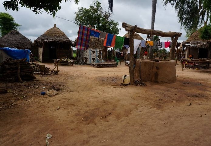
Village Wells
Thiawor receives its water through a network of uncapped, privately-owned hand dug wells
located throughout the village. There are no other sources of water available within the village
boundaries, although there are existing wells in fields where some animals graze; these are also privately
owned. At the time research was conducted, there were 8 wells within the village, of which 5 were
considered productive and safe for use. These wells are privately financed, owned, and maintained by
families within the village. The head of the household which constructed the well is in charge of financing
repairs, maintenance and upkeep, and granting permission for use of the well or water pulling materials.
Not every compound allows community members to access a well without bringing their own materials.
If a well owner or family is no longer within the village, then the upkeep falls to whomever uses or wants
to repair and maintain the
abandoned well. This has
happened in Thiawor; the well
was not used in this test because
it was in disrepair. Financing well
construction may come from
family income through
remittances; every compound in
Thiawor has a family member
who lives or works abroad. As of
2017, remittance inflows to GDP
in Senegal was 10.17% (World
Bank, 2019). Senegal, in a 2011
World Bank analysis holds fourth
place in Sub-Saharan Africa in
total volume of remittances, and
fifth place as a percentage of
GDP (Mohapatra et al., 2011).
Figure 1: A compound well in Thiawor
Water is shared and retrieved by each
compound and the households residing within it working together. This makes individual household use
difficult to quantify, and so for purposes in this report quantities will be delineated by the 14 identified
compounds lying within Thiawor. The method of water retrieval in Thiawor used in the open wells
involves pulling on a rope attached to a pulley to draw up a bucket constructed from a plastic oil
container. While it is possible to pull up the bucket alone, it is very common to see two or three people
pulling on the rope together. The water drawn up together is then split between the pullers based on the
amount or size of vessels brought to be filled. If the quantity of water to be pulled exceeds the quantity
desired of one puller, continuation of labor is optional for them and the puller may be swapped out for
13another person waiting at the well with their own vessels. Keeping track of labor is determined by the
individual and their household or compound duties. No monetary exchanges of labor around the well
were observed.
Water wells in Thiawor were dug by professional well diggers using picks, shovels, and buckets.
A pick is a common farm tool available to break the surface of the ground, as the soil becomes quite
difficult to work. During the rainy season the soil becomes more malleable, even quite muddy during
larger rain events. However, due to the work schedule and season, hand-dug wells are repaired, dug, and
maintained in the dry season. On projects for local well diggers like compound wells, a lack of tools like
motorized pumps that may assist in dredging the wells while working on a well can limit the depth to
which wells are dug below the water table. There are no existing irrigation projects for crops or gardens,
and there are no motorized or solar pump systems currently within the village.
In recent past there had been exploratory drilling in the area to build a pumped well and a water
storage tower; however, engineers miscalculated the depth to the confined aquifer in order to evaluate
how deep to drill. This led to major project funding issues, and abandonment1. It is speculated that the
reason the engineers miscalculated was because they were calculating for the unconfined aquifer, and it
was found that the recharge and availability of water would not be able to be sustained by the water tower
beyond the confines of one village. The project was supposed to supply 4-5 villages in the area. In
Senegal, remittance money is a major source of income in the small villages; villages may fund their own
private solutions while they wait for government or international aid groups to step in. Corruption in
Senegal and mistrust of the government is high.
Methods and Fieldwork
The field work of this study applied both hydrological and ethnographic data. This section addresses the
methods and field work conducted in the study area for both of these data sets. Goals of the ethnographic
field work were to understand water usage qualitatively and quantify daily domestic water use from
interviews, as well as determine if there is noted seasonal variation. For the hydrologic research,
properties of the aquifer from the bailing of the well were collected.
Pumping Tests
In the interest of determining the rate at which water is moving
through the material comprising the aquifer, a constant-rate pumping test
design was developed by bailing the wells using methods outlined by
(Shonsey & Gierke, Quantifying available water supply in rural Mali
based on data collected by and from women, 2013). Partnership with local
collaborators was necessary in order to successfully gain access and pump
water from the well. Teams were created for this purpose in advance of
the tests. The hydraulic conductivity (K) - a property to reflect the relative
ease with water can flow through a subsurface material - of the aquifer
was measured in-situ by performing five manual pumping tests and
monitoring recovery in 5 hand-dug, uncapped
Figure 2: Constructed
wells. Each of the five wells was tested once; measurement tape with hollow
the tests were performed toward the end of the container to make a sound
rainy season, and therefore all results can be when reaching the water level.
more relevant for rainy-season (best case)
1
This information was provided both anecdotally in conversations established from the author’s relationship as a Peace Corps
Volunteer, as well as from visits to the abandoned site.
14productivities. Wells were tested 8 times in total; 3 of
the 5 wells were measured twice due to initial
measurement error and material issues.
The wells were chosen for testing based on
their spatial distribution throughout the village, the
safety and condition of the wells for participant use in
the tests, and their ability to provide water during the
driest period in the year. The five wells tested were
considered the main sources of water for the residents,
and the best and most consistent in water availability.
Before the commencement of the tests, three
additional productive wells in the village were closed
off to use due to structural instability, and therefore
only five of eight wells were tested.
Figure 3: View down a compound well
In preparation for the test, each of the five wells was
covered to prevent use for approximately ten hours prior to the
pumping test to allow water levels in the wells to
return to the static (unpumped) levels. Advance
approval by the well owners was received for each
test, and a large tarp and rope were tied over the rim of
the well to prevent use overnight. Individual well tests
were conducted over the course of 8 days.
Each morning before a pumping test, the depth
to the static water level was measured and recorded.
Well diameter and well casing height were taken from
measurements of the protruding cement of the well at
the top using a tape measure. Ten hours was
approximately the longest period of time local
residents felt they could go before needs necessitated
access to the well. Two pulley systems with attached rope and a plastic Figure 5: Materials used to pump
oil bucket called a bidong were placed over the well before the test. The water from the wells
pumping tests were performed by 12 volunteers divided into four teams
of 3, with two teams pulling simultaneously for 10
minutes on a rope and switching teams for an additional
10 minutes to reach a total of 20 minutes2. All team
members participated in all five pumping tests. The water
was pulled using repurposed plastic oil containers that
were attached to rope. These repurposed plastic containers
were then pulled over two identical metal pulleys. The
water obtained was poured into 30-L plastic laundry
buckets adjacent to the well. After the 20-minute pumping
period, the contents in the laundry bucket totals were
determined to calculate total water volume extracted from
the well the pumping rate. This method of water retrieval
is the traditionally practiced form in the village and did
Figure 4: Two teams performing the
pump tests at one of the village wells
2
The term “bailing” and “pulling” for purposes of this study are used interchangeably with “pumping,” as
there are no actual pumps in these wells
15not require any additional learning from
participants. At the conclusion of each test,
the water in the laundry buckets was
distributed amongst assisting team members.
Static water level and the changes in
water level over time were measured using a
modified bucket method, fashioned with a
tape measure and a locally sourced
margarine container to use inverted to make
a sound when it “hit” the water level in the
well. A battery powered water-well
“sounder” was originally intended to
measure exact depth of the water as the
pumping test was conducted; however, it
arrived broken and unfixable, so the
“sounder” described above was used to
Figure 6: Pouring the pumped water measure the depth to the water level in the wells. Measurements were
into laundry buckets for measurement
taken at regular time intervals at start (time zero) and then after 1, 2, 3,
5, 10, 15, and 20-minute intervals. Observation periods lasted up to 595
minutes to fully recharge to static level observed before the pump test. All measurements were done by
hand and recorded in field notes. Tests were conducted between 6:15 am and 7:00 am, which is
approximately the common time water is pulled in the mornings in the village based on the author’s
observations. None of the wells were pulled from after the initial morning pump test until the author was
finished observing recharge (almost 10 hours after pumping began).
Total volumes bailed were calculated from volumes of laundry buckets collected. Table 1.1
below shows a summary of the test data collected. The water-level-recovery data for each of the wells is
displayed in the Results section of this report. After the pumping tests and recovery times and depths
were recorded, the information was analyzed with the professional hydrogeology software AQTESOLV
(HydroSOLVE, Inc., Reston, VA) to match the existing curves determined from the fieldwork to fit an
idealized type curve by modifying the aquifer parameters to fit an estimation of possible aquifer
conditions. Using these estimations, an estimation of hydraulic conductivity and idealized maximum yield
of the wells may be calculated. This information may be relevant when considering water management
systems on a local scale.
16Table 1.1 Pumping Test Data for each Well
Name of Well Sunkaro Sankare Diawara Danfakha Camara
Pre-Pumping Rest Duration
(Hr:Min) 10:15 10:30 10:30 11:00 10:15
Height of Casing (cm) 92 74 86 69 67
Width of Inner Well (cm) 111 108 118 109 96.5
Static Water Level Depth (cm) 3131 3140 3002 3002 2990
Test Duration
(Min:Sec) 12:30 20:00 20:00 20:45 20:00
Volume Bailed (L) 390 930 930 885 840
Pumping Rate (lpm) 31.2 46.5 46.5 42.6 42
Depth of Displacement (cm) 3162 3182*3 3050 3061 3051
Interview Methods
Qualitative field work was conducted in the village to determine household water usage from the wells
that were tested. This section will describe the process and methods used to understand the context of
water usage at the local village level.
3
*This is an estimation of the water level due to mechanical error at the beginning of the test
17Community members were interviewed for this study addressing seasonal household water use.
The study (1317603-1) was approved as exempt on September 24, 2018 by the Michigan Tech University
Human Subjects Committee/Institutional Review Board (IRB). This study was performed in addition to
geologic data and tests performed at the research site. Submitted to the IRB was the following statement
of purpose: “The purpose of this project is to study how local community members in a rural village in
Senegal use well water, and what their habits and uses are for domestic and agricultural needs.” Local
community members were interviewed to understand seasonal and daily water use in the village,
including amounts, how it is obtained, and for what purposes it is used for. All of these interviews were
audio-recorded and confidential. Names and titles that were revealed during the interviews were
concealed using pseudonyms during transcription. Interviewing took place in homes or around wells.
Group interviews are considered culturally appropriate, and the researcher received oral consent from all
participants.
Participants were found through observation of well activities in the morning; the author
monitored morning and evening well activity in all compounds to find interested interview participants
that were actively using the wells or those who could recommend someone in the compound. Interviews
were conducted at every compound present in the village, and participants were representative of all 23
known households within all 14 compounds. Residential compounds are open air with lots of seating and
community members passing through. The questions and oral consent were all provided in the local
village language Bambara. Before each interview, environmental observations around the well utilized by
each interviewed participant were conducted by the author. Interviews were all conducted after morning
or afternoon water retrieval.
The following questions were asked of local residents. The sampling number was picked because
it would be representative of the number of compounds in the area. Seventeen questions were asked of
participants. Below is an English translation of each of the open-ended questions asked, as well as the
introduction observation statement made to initiate the interviews:
“I am going to summarize what I observed today at the well; how much was drawn, how often you came
back, how you pulled. I have a few questions to ask about how typical or accurate my observation was”
1.Were my observations at the well typical for your household?
2.When do you or others go to get water for your household? Which water sources? What times of day?
How much?
3.How do you get water?
4.Who else comes and uses the wells – e.g., other communities or people who do not reside in town?
5.What are the hottest months typically? Is it always the same every year or does that vary?
6.What month is it hardest to obtain water? Have village wells ever run dry? If so, when does this typically
happen?
7.Have there been times of day when the water in the well is not enough for the day? If so, when does this
typically happen?
8.Does how your compound obtains water change by season? Explain.
9.What work does the water you obtain do? What uses?
10.How many buckets are filled for your compound when someone goes to get water? How many times a
day do you or they get water?
11.What do people do if a well is dry?
12.If someone cannot retrieve water for your compound from the nearest well, what do you do?
13.What is your compound's strategy when you realize there is a problem with the well water? What kind
of problems with the water quality and quantity have there been?
1814.What do you do involving agriculture and well water use? Or rephrase: …Do you use well water for
agriculture or gardening? Care for animals? Please describe these activities and about how much water is
used for them on a daily (and possibly seasonal) basis?
15.How important is agriculture to this community? Do others use well water for agriculture, gardening, or
animal care? If so, same as above.
16.When you or your parents were younger, how did they obtain water? Explain. Did this change by
season?
17.When does rainy season start and end? Has this changed from when you were younger?
Audio interviews were recorded using iPhone voice memo and saved to a locked private digital database
with restricted access. The interviews were transcribed directly in the local language Bambara from the
original audio recordings; care was taken to conceal identities and pseudonyms were used in compliance
with IRB. In total, fourteen interviews were conducted, which coincides with the number of compounds
within the village. The qualitative analysis software Atlas.ti was used to analyze the interviews conducted
in the study. Seventeen codes were created from these interviews; the codes were then used to provide
understanding and context of water usage in the village, as well as provide quantitative data of water
volume per household.
Interviewees were asked to provide the number of wash basins and or jerry cans they fill for each
purpose. An understanding of local water retrieval methods was obtained by having the interviewer
describe her observations of methods at the well before the interview, and then asking residents to explain
in detail if these observations were typical. In addition, opinions concerning water quality, seasonal water
retrieval strategies as well as productive well availability, and seasonal water use were discussed in the
interviews. In total, 14 interviews with participants representing every compound in the village were
successfully conducted. Interviews lasted for an average of 19 minutes.
RESULTS
The results section is split into two sections: interview data analysis and pumping tests and analysis in
AQTESOLV. Preliminary understanding of seasonal water usage is gauged from these observations and
interviews. Localized aquifer and well conditions are estimated from the pumping test data and
AQTESOLV analyses.
Interview Data Analysis
The purpose of this study is to understand domestic water usage at a small village level and
understand whether rainy season availability currently meets identified needs. From these interviews, an
understanding of conditions around wells in Thiawor are elaborated on specific usage, water retrieval,
concerns and informal strategies to deal with issues concerning the wells. While there is slight variation in
water allocation depending on agricultural productivity, community members are allocating water to the
same five core purposes overall: drinking water, cooking water, washing, watering animals, and gardens.
From the quantities allocated to each usage in these interviews, average compound consumption in
Thiawor is 540 liters per day, for a total village consumption of 7,560 liters per day.
The water retrieval methods are the same throughout the village; using a metal pulley and rope
with a bucket on the end to haul water. There are set times in the day when it is most common to retrieve
water – early morning and afternoon specifically, and water labor is split into teams, with water quantity
tracked as it is retrieved from the well so that there is a fair distribution of labor. This work distribution
results in water depletion of the wells twice daily (mornings and evenings), as well as gatherings of
people around the well assisting or waiting for their turn.
Strategies and well etiquette were unexpected findings with regard to dealing with difficulties in
the face of water sourcing issues. Seasonal water scarcity was noted from March to June, sand there are a
19variety of strategies implemented around the usage of the various wells in the village. Some strategies
include waiting by the wells and pulling small amounts or visiting other neighbors’ wells with
permission. When water needs to be drawn from wells away from the compound, primarily the next
closest is visited, a well is chosen that is less occupied or avoids local drama, and/or donkeys are utilized
to assist in the load of pulling and carrying water. There is etiquette involved in the usage of wells; all of
the wells are privately owned, but there is an open understanding of shared usage amongst compounds
especially because familial ties exist between households. Whether or not materials such as pulleys, rope,
and buckets are provided to pull the water from the well depends on the well owner’s permission. Water
quality concerns were also voiced; the wells are uncapped and unimproved, and as a result often require
maintenance when they are contaminated or dry. An understanding of hand dug well maintenance
procedures was gained through these interviews. Well choice strategies were also revealed in relation to
those maintenance procedures and decommissioning of wells due to water quality concerns.
Overall, daily water needs in the rainy season are considered met by the wells currently in
Thiawor. Interviewees mentioned increased numbers of wells at present – eight in Thiawor compared to
their past times, when there were only two. But they elaborated that the amount of water available from
the two wells in their youth was greater. While there is not enough local data to make any comment about
changes in water availability over time, it is of interest that participants actively brought up increased
water scarcity compared to their pasts.
This analysis used codes in Atlas.ti to build reports looking for patterns in the interview data to
interpret from the interviews. Seventeen codes in total emerged from analysis of the interview data
gathered. While not all are discussed in this study, participants particularly focused on Water Quantities,
Water Usage Purposes and Allocations, Seasonal Well Usage, Water Retrieval Methods, Water Retrieval
Times, Water Scarcity and Well Problems and Remedy Strategies, Well Work Distribution, Water
Quality, and Historic Well Usage.
Water Purposes and Allocations
Domestic water usage purposes as well as daily usage quantities were identified based
on purposes identified by each participant from every compound interviewed. The water uses in Thiawor
were provided from these interviews to give a broader context of what the situation and implications are
for local residents including calculated recharge observations of the actual availability.
The most frequently mentioned purpose of water in the compounds:
• Drinking water, stored in clay vessels in each compound
• Cooking, stored inside or around cooking areas
• Washing clothes, dishes, bathing, cleaning toilet areas
• Watering animals, a seasonally dependent activity for hot and dry season
• Watering the gardens, another seasonally dependent purpose at the end of hot and dry season
Four compounds said that they maintain gardens outside of the major agricultural rainy season. These
compound gardens are attached to the main living areas of the compound within the village boundaries
and are watered using domestic wells. Compound gardens are an additional nutrition source for many
Senegalese farmers, often promoted by NGO projects with the goal of additional household income or
increasing local access to fresh nutrient sources. In the interviews conducted, research participants
identified whether or not they were doing garden activities and the amount of water they were obtaining
for vegetable cultivation.
20You can also read