Re-Visiting Viking Vinland: II. 'Virtual Excavation' of 'Keelness', a Viking Shipwreck Site in North America
←
→
Page content transcription
If your browser does not render page correctly, please read the page content below
Preprints (www.preprints.org) | NOT PEER-REVIEWED | Posted: 20 January 2023                                doi:10.20944/preprints202301.0367.v1

Disclaimer/Publisher’s Note: The statements, opinions, and data contained in all publications are solely those of the individual author(s) and
contributor(s) and not of MDPI and/or the editor(s). MDPI and/or the editor(s) disclaim responsibility for any injury to people or property resulting
from any ideas, methods, instructions, or products referred to in the content.

       Article

       Re-Visiting Viking Vinland: II. 'Virtual Excavation' of
       'Keelness', a Viking Shipwreck Site in North America
       Haynes, R. 1*, Franklin, M.S. 2, Goosney, J. 3, Goosney, D. 3

                                         1. Osher Lifelong Learning Institute, University of Delaware, Lewes, DE, 19958, USA ORCID: 0000-0003-0883-
                                         2330
                                         2. Timmons Group, Richmond, VA, USA; Matt.Franklin@timmons.com
                                         3. Aguathuna Drafting and Consulting Co. Ltd (ADC), Port aux Port East, NL, Canada; Jamie@adcengineer-
                                         ing.ca (J.G.); Denise.goosney@gmail.com (D.G.)
                                         * Correspondence: thorroy@udel.edu

                                         Abstract: The series of papers, 'Re-Visiting Viking Vinland', encompasses a re-evaluation of the
                                         Viking voyages from Greenland to North America, from about 985 to 1026 A.D. Searching for their
                                         American landfalls used multiple approaches: clues from Norse sagas, logic, creative imagination,
                                         and advanced imaging technology. Paper I described locating 'Keelness', a Viking shipwreck site in
                                         Newfoundland, Canada, but Covid-19 prevented professional, on-site follow-up. Paper II describes
                                         our alternative, a 'virtual excavation', using only remote imaging via drone, plus advanced data-
                                         processing of both visible and thermal (infrared) data. Starting with the 'stocks', a support structure
                                         for Viking ship repair, other features were accidentally found, identified, and interpreted. These
                                         included damaged hull planks ('strakes'), parts of the broken keel, a pit-house for shelter, and the
                                         hole where a keel-piece was erected as a navigational marker; with the site named (Norse,
                                         'Kjalarnes') ('Keelness' or Keel Point). Results of this non-contact, non-destructive 'virtual excava-
                                         tion' supported our hypothesis that this site is the 'Keelness' mentioned in the Norse sagas. Frag-
                                         ments of Leif Eriksson's original ship may still be preserved in a sphagnum moss bog after 1000
                                         years, accessible for further study, and perhaps providing valuable information on both proveni-
                                         ence (origin) and provenance (history) of these iconic artifacts.

                 © 2023 by the author(s). Distributed under a Creative Commons CC BY license.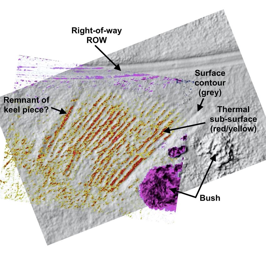
Preprints (www.preprints.org) | NOT PEER-REVIEWED | Posted: 20 January 2023                       doi:10.20944/preprints202301.0367.v1

                                                                                                                                2 of 21

                                      Keywords: Viking; Vinland; Keelness; remote imaging

                                      Introduction
                                      1. Re-visiting Viking 'Vinland''- the Series
                                           'Re-Visiting Viking Vinland' is a series of papers describing re-evaluation and re-in-
                                      terpretation of Viking voyages from Greenland to North America, dating from about 985
                                      to 1026 A.D. Paper I described the voyage of Leif Eriksson's brother, Thorvald Eriksson,
                                      and locating his shipwreck site, 'Keelness', in Newfoundland, Canada (1). Covid-19 fallout
                                      restricted site access and affected the ability to enlist certified professional assistance for
                                      follow-up. As an alternative, a 'virtual excavation' of the entire ship repair site was carried
                                      out, using only imaging data from preliminary drone scans, as described here in Paper II.
                                      Later papers will address imaging evidence for the site of Thorvald's subsequent death,
                                      and a later voyage led by Thorfinn Karlsefni, who may also have occupied this same site.

                                      2. Paper I Re-cap
                                           Paper I described the circumstances of Thorvald's fateful voyage, and how we re-
                                      imagined his route from 'Leif's Booths' to 'Keelness'. Fig. 1 shows the heart of 'Vinland',
                                      including specific landmarks and locations. It also summarizes the first two phases of this
                                      project; locating Leif's Booths, the voyage's starting point, and tracing Thorvald's trajec-
                                      tory to the shipwreck site.

      Fig. 1 - Central area of 'Vinland', with Thorvald Eriksson's hypothetical route. 'Leif's Booths', 'Keelness', L'Anse aux Meadows,
                       and other key locations indicated. (Derived from demis.nl image under Creative Commons License)

                                          The entire shipwreck episode was described in Greenlanders' Saga (GS) in only three
                                      cryptic sentences (with 'clues' to the discovery highlighted):
Preprints (www.preprints.org) | NOT PEER-REVIEWED | Posted: 20 January 2023                  doi:10.20944/preprints202301.0367.v1

                                                                                                                            3 of 21

                                      “Next summer Thorvald sailed east with his ship and then north along the coast.
                                      They ran into a fierce gale off a headland and were driven ashore; the keel was shat-
                                      tered and they had to stay there for a long time while they repaired the ship. Thorvald
                                      said to his companions, ‘I want to erect the old keel here on the headland, and call the
                                      place Kjalarnes (Keelness)” (Magnusson and Palsson, 1965) (2).
                                        Using saga clues, logic, and creative imagination, we described the process by which
                                 we located his shipwreck site, on the north coast of the Great Northern Peninsula, in New-
                                 foundland, Canada. A single satellite image suggested a support structure, characteristic
                                 of Viking ship construction. Drone imaging verified our sighting, while accidentally re-
                                 vealing other ground features, and reinforcing our initial suspicions. We ended Paper I
                                 with a topographic map of the entire ship repair site, showing the visually enhanced to-
                                 pography, locating the features, and alluding to our initial analysis of the finds.
                                        The ship was rebuilt, perhaps over two calendar years (GS states merely a "long
                                 time"), and eventually carried the crew (minus Thorvald) safely back to Greenland. When
                                 confirmed, 'Keelness' (Keel Point) will be the first specifically named Viking site found in
                                 North America, located at 51O.36'.54.36" N, 55O.51'.21.02" W. Only 22 km (14 miles) from
                                 L'Anse aux Meadows (LAM), suggests a connection between the two sites, (Fig. 11), and
                                 it is very plausible that both sites were established and occupied at the same time.

                                 3. Difficulties in Viking Vinland Research
                                       A very recent paper by Ulrich Johann, pursuing a similar investigation, has likewise
                                 addressed the inherent difficulties in pursuing this subject (3). The Vinland sagas are es-
                                 sential, because they are the only documentary source we have. But they are fraught with
                                 difficulty, because there is so little information; much of it surely fiction, the rest question-
                                 able, and no way to tell the difference. On the other hand, assuming that everything in the
                                 sagas is fiction, makes trying to locate Viking sites little better than throwing darts at a
                                 map. Except for Helge Ingstad (L'Anse aux Meadows), more than 200 years of intense
                                 scholarship has failed. Previous historians maybe succumbed to the illusion that saga
                                 'facts' were somehow 'proof' of their hypotheses, rather than preliminary clues of where
                                 to look by other means. With many new technologies presently available, now was the
                                 time to try anew. We are in agreement that everything will remain hypothetical, until ex-
                                 cavations take place, and artifacts are authenticated. Until then, the search is equally as
                                 engaging as any discovery, and perfect for retired scientists, with time on their hands.

                                 4. Presentation of the Narrative
                                       Our results may be presented as, 'this is the way it might have happened', in the
                                 interests of brevity and continuity, but in reality, we don't know and will probably never
                                 know the 'truth'. These hypotheses are just that, working hypotheses; the best we can do,
                                 with the limited information available, and that is how they should be interpreted. We are
                                 not naive enough or egotistical enough to think that what we present is the 'truth'. It is
                                 just a starting point, for professional archaeologists to eventually extend our knowledge
                                 and understanding of this pivotal era of human civilization.

                                 Materials and Methods
                                 1. The 'Vinland' Sagas
                                        As previously described, the foundational materials for this study were the Norse
                                 'Vinland' sagas, Greenlanders' Saga (GS), and Erik the Red's Saga (ERS). Some Vinland
                                 scholars still insist that these sagas are merely fictional, but we found them essential for
                                 imagining locations and events so vividly described. Despite indisputable flaws, they are
                                 still the only documentary, eyewitness reports available, and our study shows that some
                                 degree of confidence in the sagas was justified. Creative imagination fills in the gaps, re-
                                 sulting in a comprehensive narrative which can perhaps serve as a guide for further ar-
                                 chaeological investigation.
Preprints (www.preprints.org) | NOT PEER-REVIEWED | Posted: 20 January 2023               doi:10.20944/preprints202301.0367.v1

                                                                                                                       4 of 21

                                 2. Maps and Geography
                                      Progress in Vinland Viking history was hampered for close to two centuries by the
                                 inadequacy of available maps. The futile, non-productive search for 'Vinland' on the
                                 northeast coast of the United States may have been due as much to poor maps, as it was
                                 to misplaced patriotism. Only recently, with satellite imaging, have highly detailed maps
                                 become widely and publicly available, (Google Earth, Apple Maps, ESRI, Maxar Technol-
                                 ogies, satellites.pro, etc.), revolutionizing both, geography and subsequently archaeology.
                                 Satellite imagery allowed us to imagine the trajectory of the ship (map, Fig.1). Since a
                                 shipwreck was involved, we integrated nautical maps and underwater topography to
                                 identify structures which could have contributed to a shipwreck. Modern nautical charts,
                                 were used to create an imaginary scenario, consistent with both topography and climatol-
                                 ogy, as described in Paper I.

                                 3. Remote Sensing - Drone Imaging
                                      Technical details of the equipment, techniques and methods used for data acquisition
                                 and analysis will be covered in a separate paper (Franklin et.al., in preparation). Here we
                                 concentrate primarily on the interpretation of the imaging, and how that was used to con-
                                 struct a plausible narrative for the activities which may have occurred on this site.
                                      A suspicious satellite image of unnatural parallel lines might previously have trig-
                                 gered a physical site excavation; but another recent attempt at locating a Viking site in
                                 Newfoundland had failed at exactly this point. For us the temptation was moot because,
                                 as non-professionals without a permit, we could not pursue an excavation anyway; and
                                 enlisting professional help based on a single satellite image was impossible. Changing
                                 direction, and primarily just to confirm the authenticity of a satellite image, we turned to
                                 non-contact, non-invasive, non-destructive drone imagery. In our judgement, remote im-
                                 aging was benign, posing no more danger to the site (perhaps even less) than tourists
                                 taking photographs; scanning only public property, and controlled from a public right-of-
                                 way (ROW) to protect the physical integrity of the site. Because this site was rather remote,
                                 there was considerable cost for the drone deployment alone. But since the basic cost was
                                 already committed, we made the strategic decision to scan as much area as geographically
                                 and economically feasible, while adding thermal (infrared) imaging to the sensing suite.
                                 In retrospect, this turned out to be a wise decision.
                                      If the satellite image were to be confirmed, and with thermal imaging as an extra
                                 dimension, there could be other features, undetectable by satellite imaging alone. It was a
                                 calculated gamble, but ultimately successful. The drone imaging accidentally revealed not
                                 only numerous additional surface features, but also sub-surface features (via thermal/in-
                                 frared). With in-person investigation restricted by Covid-19, advanced, digital data-pro-
                                 cessing was applied to the preliminary drone data, creating detailed 'virtual' images, as
                                 described in Results and Discussion.

                                 4. Data-processing - visible
                                      The raw drone data, taken from an elevation of about 130 ft (40 m), in the visible
                                 spectrum, was processed using ArcGIS software developed by Environmental Systems
                                 Research Institute (Esri, formerly ESRI). This methodology was previously used by
                                 co-author M.S.F., in researching neglected Black cemeteries in Richmond, VA., by
                                 creating various 'synthetic images' (especially hillshade) for 'enhanced visualization' and
                                 analysis (4). Examples of the results in this application are presented in Results and Dis-
                                 cussion, amply demonstrating the value of this technology.

                                 5. Data-processing - thermal/infrared
                                       An excellent overview, regarding use of aerial thermography on archaeological sites
                                 is given in a paper by Casana et. al (2017) (5). Thermal/infrared scans were processed us-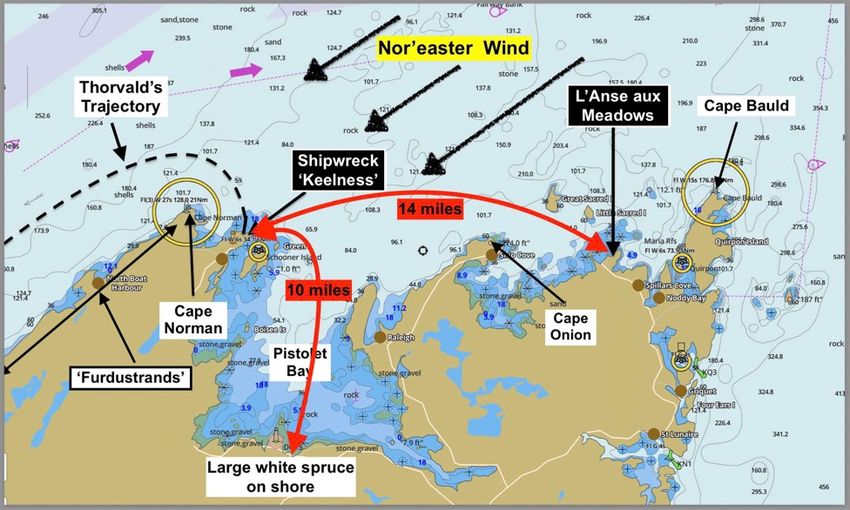
Preprints (www.preprints.org) | NOT PEER-REVIEWED | Posted: 20 January 2023                 doi:10.20944/preprints202301.0367.v1

                                                                                                                          5 of 21

                                 ing FLIR (Forward Looking InfraRed) software, accentuating the varied thermal signa-
                                 tures of both surface and sub-surface objects and features. FLIR advanced thermography
                                 is a technology originally developed for the US military, but now with many civilian ap-
                                 plications. The website of the manufacturer, Teledyne, is most informative on the specifics
                                 of FLIR (6). Most readers will be unfamiliar with thermography, and especially its use in
                                 archaeology, so a brief tutorial may be helpful.
                                       Thermographic sensors and instruments do not measure temperature directly, as by
                                 contact, and do not create 'real' images, as with a photograph. Instead, they remotely de-
                                 tect and measure infrared (thermal) radiation being emitted by objects in their view. All
                                 material objects absorb energy from their environment, but they re-emit that energy with
                                 varying degrees of efficiency, on a scale of 0 to 1.0. This efficiency is called emissivity.
                                 Zero (only theoretical) is like a perfect mirror, which reflects all light, without absorbing
                                 any of its energy. At the other end of the scale, 1.0 is a 'perfect black body', which absorbs
                                 100% of the energy impinging on it, and then re-emits 100% of that energy, at a wave-
                                 length NOT related to its composition, but directly related to its temperature. This is de-
                                 tected by the FLIR system as 0 being 'colder' than 1 being 'hot'. Advanced cryogenically
                                 cooled sensors are now capable of measuring 0.025o C differences! Our results were not as
                                 discriminatory, but impressive nonetheless, and more than adequate for locating, identi-
                                 fying, and analyzing sub-surface archaeological features.
                                       Emissivity is not only affected by the identity of the material itself, but by its surface
                                 characteristics: texture (roughness), density, chemical effects (e.g. oxidation/corrosion),
                                 hydration, geometry, view angle orientation, etc.). All of these surface effects on the emis-
                                 sivity allow incredible discrimination between objects in the image, which can be en-
                                 hanced by 'tuning' the data-processing phase of the analysis. The detection system
                                 measures the intensity of the radiation in every pixel of the sensor, at rapid intervals, and
                                 stores that information in a digital format. As one can imagine this results in an incredible
                                 amount of stored data; taking hours or days to download, days or weeks to process, and
                                 weeks or months to analyze. Computer processing of all the data, produces useable im-
                                 ages, with incredible discrimination, fidelity, and malleability. As stated, the output does
                                 not produce a true image, like a photograph, but a 'synthetic image' which can be digitally
                                 manipulated and enhanced at will, enhancing different information about the objects in
                                 view.

                                 6. Logic and Imagination
                                      The combination of logic and creative imagination had paid off in locating the ship-
                                 wreck site (1). Now the time had come, to not only pinpoint locations of specific features,
                                 but to see if this same strategy could be applied to interpret the roles which these features
                                 may have played in the overall ship repair narrative.

                                 7.'. Virtual Excavation'
                                       Unable to enlist and/or retain a qualified archaeologist for on-site investigation/exca-
                                 vation, we turned to a 'virtual excavation'. Here, remote, non-invasive, non-contact digital
                                 imaging, advanced data-processing, and human imagination, substitute for trowels, buck-
                                 ets, brushes, and screens. Physical excavation will still ultimately be required to tell the
                                 complete story, filling in details which only 'hands-on' activity can provide. But until that
                                 becomes possible, a detailed overall view of the entire ship repair site, and a basic outline
                                 of the ship repair narrative will be waiting, for others to confirm, refute, expand, modify,
                                 or ignore as they deem appropriate.

                                 Results and Discussion
                                 1. Confusion - 'Stocks' and 'Strakes'
                                      With a high degree of confidence in locating the 'Keelness' site, this is where we tran-
                                 sitioned from merely confirming a satellite image, into a full-fledged 'virtual excavation'.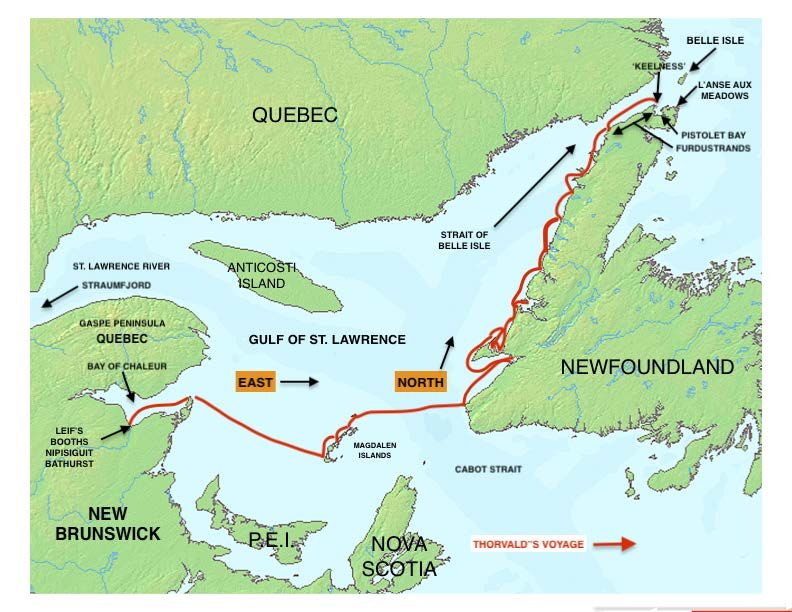
Preprints (www.preprints.org) | NOT PEER-REVIEWED | Posted: 20 January 2023 doi:10.20944/preprints202301.0367.v1
6 of 21
Without site access, we needed creative imagination to analyze the preliminary drone
data, and then advanced data-processing to interpret what we were seeing. We were ini-
tially stunned, and puzzled, when we saw the first visible image of the feature tagged by
GPS on the satellite image. This first image was a series of parallel lines, but a completely
different pattern than the one we expected. After much concern and confusion, we real-
ized that this was not the one we were looking for. Fortunately, serendipity had smiled
upon us, and looking around on the wider image, we eventually found our original target.
It turned out that there were actually two different sets of parallel lines, within about
150 ft of each other. By truncating the GPS decimal points, they had showed up at exactly
the same GPS location on the scans. After weeks of analysis and interpretation, we con-
cluded that the first drone image suggested an array of damaged hull planks (called
'strakes'), removed from the hull, and perhaps used as patterns or templates for replace-
ments. We return to this feature later, but for now we follow up on the original satellite
image; interpreted as the 'stocks'. We tried to get input from experts in Viking ship con-
struction and repair, without success. The descriptions which follow are our amateur at-
tempts to visualize the challenges the crew faced, and what the images tell us about how
they might have dealt with them; hypothetical, but at least plausible.
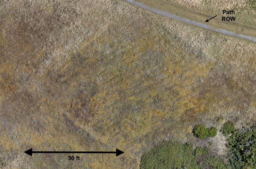
Fig. 2 - ArcGIS hillshade image of entire ship repair area, with primary features indicated.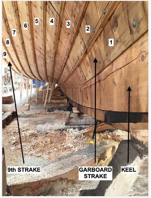
Preprints (www.preprints.org) | NOT PEER-REVIEWED | Posted: 20 January 2023                   doi:10.20944/preprints202301.0367.v1

                                                                                                                             7 of 21

                                 2. Stocks
                                      Preparing for repair, they had to construct the 'stocks', a stable base on which to ele-
                                 vate and stabilize the hull. See Paper I, Fig. 8 A,B, and associated Smithsonian Institution
                                 YouTube video (7) for how this structure was used. This job called for ingenuity. Nor-
                                 mally, a Viking ship was constructed on the stocks, from the keel up, adding one strake at
                                 a time, and as it grew, adding additional 'props' along the outside of the hull for support.
                                 But here, the keel and the entire underside of the ship had to be replaced: the keel and 18
                                 strakes, 9 strakes on either side of the keel. Figure 3, the Myklebust Viking ship repro-
                                 duction, illustrates the extent of the repair. During disassembly, it would have to be sup-
                                 ported almost entirely by the inner framework (possibly from above), and outside props
                                 angled only to the upper part of the hull. This is where professional input would have
                                 been invaluable, but unfortunately not available.

                                 Fig. 3 - Underside of reproduction Viking ship, Myklebust, demonstrating extent of damage to Leif's
                                 ship during shipwreck; keel and 18 strakes, 9 on each side of keel. (Reproduced by kind permission
                                 of photographer Christina Keune).

                                       The drone hillshade image, (paper I, Fig. 7B), showed that 22 logs, each about 52 ft
                                 (16m) long, had been laid down on 6.6 ft (2 m) spacing, probably connected by perpendic-
                                 ular 'stringers' underneath (no longer detectable). There was surely plenty of driftwood
                                 of all sizes available on-site: perhaps damaged by Teredo shipworm, but adequate for this
                                 temporary application. The entire stocks array had a length of about 135 ft (42 m), indicat-
                                 ing that this structure was intended for a huge ship, probably at least 85 ft (26 m) long.
                                 With the stocks completed and ready to receive the hull, now they had to get the hull from
                                 the cove where it was resting, to the stocks (see paper I, fig. 4).

                                 3. Slipway
                                      First, they had to get the ship out of the water; how did they do that? This was a huge
                                 ship for its time, probably around 85 +/- ft long (26 m), 22 +/- ft (7 m) wide, weighing 20 to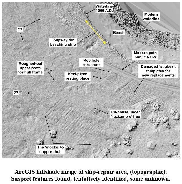
Preprints (www.preprints.org) | NOT PEER-REVIEWED | Posted: 20 January 2023                 doi:10.20944/preprints202301.0367.v1

                                                                                                                          8 of 21

                                 30 tons (18,000 - 27,000kg), cargo capacity of >80 tons (73,000 kg). This is much larger than
                                 most other, previously known, ocean-going, Viking 'knerrir' (plural of 'knarr'). With only
                                 perhaps 25 crew available, everything about handling this ship would be a challenge.
                                 With input from someone familiar with sailing and servicing a lapstrake ship, we con-
                                 structed the following narrative, but still hypothetical and subject to change at any time.
                                       Their first task was probably to assess the extent of the damage, before Thorvald
                                 could formulate a plan of how to proceed. With significant holes in the hull, and tons(?)
                                 of ballast rocks still inside, the ship was probably gently resting on the bottom of the cove,
                                 with the underside of the ship under several feet of water. They needed to beach it, so
                                 they could assess the condition of the bottom strakes, from both inside and out. We think
                                 they may have maneuvered the ship parallel to the shoreline, and as close as possible. To
                                 lighten the hull, they likely removed the ballast stones and stockpiled them on the beach,
                                 for later reuse. On the next set of really high tides, they would have careened the ship on
                                 the beach, perhaps using the mast as a lever, tipping the ship over to one side, and then
                                 on the next tide, over to the other side. This would allow inspection both inside and out,
                                 while mentally putting together a materials list, and formulating a plan for reconstruction.
                                 They must have immediately realized that this would not be easy, much more than a sim-
                                 ple repair, and more like a reconstruction, replacing the entire keel, and all 18 bottom
                                 strakes.
                                       We think that they may have constructed a set of 'cradles', and attached them at in-
                                 tervals along the hull, preserving and stabilizing the shape and structure as much as pos-
                                 sible. Connecting the cradles laterally to each other, and with a multitude of props up to
                                 the upper strakes, they could now handle the entire ship as a relatively stable and cohesive
                                 whole, and be able to maneuver it in all directions by means of levers and rollers. The
                                 extent of the damage probably dictated construction of a sturdy set of stocks as described
                                 earlier.
                                       Scanning the nearest shoreline, there is one straight stretch of shore, which appeared
                                 to have short 'stubs' jutting out at repetitive intervals (Fig. 2). This suggested that, with
                                 the ship already on the beach, they might have constructed a 'slipway', for pulling it up
                                 sideways, to get it well clear of the water. We imagined them using long, uniformly sized
                                 driftwood logs (maybe 50 +/- ft (16 m long), similar to the construction of the stocks. If
                                 true, they may have placed logs about 2 ft apart, perpendicular to the waterline, with the
                                 total array about 85 ft wide. Attaching the cradles would have been a challenge; perhaps
                                 assembled while the hull was still careened on the beach between tides. With the cradle
                                 assembly securely in place, they may have attached extremely strong walrus-hide ropes
                                 to both bow or stern. Perhaps with an A-frame lever device for force-multiplication, they
                                 could then 'walk' the ship up the incline, very slowly, one end at a time. With the hull at
                                 the top of the slipway on more level ground, they could then proceed to slide the ship
                                 about 130 ft (40 m), over to the waiting stocks: likely using a combination of log rollers
                                 over trackways for support, and levers for both pushing and pulling.

                                 4. Imagining the Ship
                                       Even scholarly publications portray Leif Eriksson's ship as a high-status 'longship'
                                 (Norse: 'langskip'), with dragon head prow, and row of shields along the gunwale; roman-
                                 tic, visually appealing, but surely false. Leif's ship would have been a 'knarr', a merchant
                                 ship, a freighter designed to carry as much valuable cargo as possible. Evidence for two
                                 separate pieces of the broken keel at Keelness (described later), suggest a total keel length
                                 of about 65+ ft (20 m); consistent with a ship close to 85 ft (28 m) long overall. By compar-
                                 ison, combined length of excavated keel pieces of the Bryggen 'Big Ship', excavated in
                                 Bergen, Norway, is 74 ft (23 m). Experts estimated the length of that ship at about 27 - 30
                                 m (89 - 99 ft); so certainly, in the same size range (8). The relatively straight, ~72-foot cen-
                                 tral sections of the 'strakes', described below, are again consistent with an 85 +/- ft long
                                 ship.
Preprints (www.preprints.org) | NOT PEER-REVIEWED | Posted: 20 January 2023 doi:10.20944/preprints202301.0367.v1
9 of 21
Because of its size, experts speculated that the Bryggen "Big Ship" may have been a
king's ship, or perhaps owned and operated by a wealthy merchant cooperative, rather
than a single individual. With the 'Keelness' ship we speculate, that as presumptive para-
mount chief of Greenland after Erik the Red's death, Leif may have felt entitled to such
extravagance; and with the rewards from his Vinland trip, the gamble seemed to have
paid off. If even close to correct, this was a substantial ocean-going ship, bigger than most
known 'knerrir' (pl.) of that time, and about 200 years before the Bryggen ship. The goal
was cargo volume, and the more, the better. Cargo was money, and these were hunter-
gatherers and merchants first, explorers a distant second.
5.'. Strakes'
We now return to the 'strakes'. The other set of parallel lines was initially a confusing
puzzle: 18 of them, very long, about 72 ft (22m), and narrow, about 16 in wide (38 cm).
Entertaining various ideas: a wood lot, glacial striations on rock, and even the rows of an
abandoned potato patch (!), we eventually imagined them as an array of damaged hull
planks (‘strakes’), removed from the bottom of a damaged Viking ship. Figures 4 A, B
shows the drone imaging in both visible spectrum (4A), and the ArcGIS hillshade deriva-
tive image (4B), showing the value of this transformation. But why were they laid out so
neatly, and left there? In our hypothesis, they may have been laid out in the order of their
positions in the hull and used as patterns or templates for fabricating exact replicas, using
local 'green' wood. Nearby LAM had previously been suggested as the site of a boat re-
pair, because of the concentration of cleaved boat rivets found during excavations (99 to-
tal). Wooden artifacts were also found, suggesting templates for reproduction of damaged
parts, so our idea was neither unusual nor unique (9). Viking ship experts questioned this
interpretation, but declined to suggest an alternative, so at this time we see no better or
reasonable alternative. Eventual excavations may reveal the answer, but ultimately, we
may never know for sure.Preprints (www.preprints.org) | NOT PEER-REVIEWED | Posted: 20 January 2023 doi:10.20944/preprints202301.0367.v1
10 of 21
Fig. 4 A, B - Comparison images of strake array, visible view (4A) versus hillshade view (4B).
6. Thermal Images
Now we turn to more 'synthetic images', combining both ArcGIS and FLIR; revealing
details not normally visible. These allowed us to 'zoom' down, seeing smaller and smaller
details, down to the centimeter level, a true 'virtual excavation'. Initially, advanced data-
processing had produced a topographic image (ArcGIS hillshade) of the area, showing
the present surface contours, relative to the visible view Fig. 4 A, B), interpreting Fig. 4B
as the array of damaged strakes. Thermal imaging of this same feature now allowed us to
'see' beneath the surface, showing details not evident in the visible spectrum. Despite an
intervening millennium, thermal imaging indicated that there might still be intact mate-
rial beneath the surface.Preprints (www.preprints.org) | NOT PEER-REVIEWED | Posted: 20 January 2023 doi:10.20944/preprints202301.0367.v1
11 of 21
Fig. 5 - Overlay of thermal data pattern, over the hillshade rendering of the surface topography.
Using Adobe Photoshop©, the thermal image was superimposed over the hillshade
image, producing the striking result shown in Fig. 5. The grey background is the hillshade
surface image, showing the positions of the original objects; but by now expanded by
sphagnum moss growth, and slowly accumulating environmental debris. The thermal im-
age shows differential thermal radiation, relative to the surrounding matrix, emitted by
objects below the surface. While much of the strake wood appears to have rotted away,
this image suggests that a reasonable amount of wood may still be present and relatively
intact, even after 1000+ years.
A consulting archaeologist stated that wood surviving for 1000 years would be "im-
possible", while a medieval historian declared it "inconceivable". However, wood artifacts
were excavated at LAM (only 14 miles away) in almost perfect condition, and yet precisely
dated to exactly 1021 A.D. (10). Wood preservation at LAM was due to 'unusual condi-
tions': a continually wet, anaerobic, cold, peat bog. Could not conditions at this nearby
shipwreck site be equally unusual, unexpected, and successful? Supporting evidence is
the largely intact, 2000-year-old human remains ('bog bodies') and organic artifacts, re-
covered from sphagnum peat bogs in Europe (11). Sphagnum moss creates its own uniquePreprints (www.preprints.org) | NOT PEER-REVIEWED | Posted: 20 January 2023 doi:10.20944/preprints202301.0367.v1
12 of 21
environment as it grows: constantly wet, acidic, and anaerobic, while secreting sphagnan,
an antimicrobial polysaccharide which inhibits biodegradation. Sphagnum moss was doc-
umented on Burnt Cape, the next peninsula east of 'Keelness', and was tentatively identi-
fied at Keelness under almost identical environmental conditions. In this sub-arctic cli-
mate, a sphagnum bog expands by only about 0.5 to 1 mm per year (12). So, after 1000
years, we imagine the strakes 'cocooned' under about 18 inches (0.5 m) of sphagnum moss
in a 'raised bog'. Strake wood from Leif Eriksson's original ship, exposed to conditions like
the bog bodies, could well be 1000 years old!
We hypothesized 18 damaged strakes, from keel to waterline (see Fig. 3), carefully
removed, and kept as intact as possible. Packing them in local sphagnum moss, and keep-
ing them continuously wet, would prevent drying, warping, and shrinkage, so they could
be used as templates. This may be analogous to modern conservation procedures, where
synthetic chemicals are used to infiltrate, and preserve both the shape and size of water-
logged wooden ship artifacts. Even though superb woodworkers, these Vikings were not
ship-builders. But reproducing exact replicas of damaged strakes could mean the differ-
ence between life and death, when later sailing the rebuilt ship across the North Atlantic.
This was important! The severity, scope, and location of this shipwreck now hinted at why
the L'Anse aux Meadows site may have existed in the first place. With imagination, pieces
of the puzzle appeared to be coming together.
Zooming in even further, another provocative find in our 'virtual excavation' were
the white spots on the infrared images. Our drone expert (J.G.) identified them as 'thermal
hot-spots' (Fig. 6), suggesting metallic artifacts based on their enhanced differential ther-
mal radiation (emissivity). 'Metal', juxtaposed with 'strakes' immediately suggested that
remnants of individual rivets might still be present in-situ, which future physical excava-
tion may confirm. 99 rivet remains (mostly rust) were excavated at LAM (13), leading to
the conclusion that LAM was a shipbuilding / ship-repair site, and the same logic may
also apply here.
Fig. 6 Enlarged image of part of thermal-over-hillshade overlay rendition of the strake array: showing what appear to be rivet
fragments, still embedded in strake wood, and the largely still-intact edge of the outermost strake: 9th out from the keel.Preprints (www.preprints.org) | NOT PEER-REVIEWED | Posted: 20 January 2023 doi:10.20944/preprints202301.0367.v1
13 of 21
7. Interpreting the Strakes
There were other interesting features of the strakes. There appears to be about 14 feet
missing from the ends of 3 adjacent strakes, strakes 7, 8, and 9, numbered out from the
keel, on the front starboard side (Fig. 4B). We assume that after the initial, keel-shattering
collision, the crew immediately headed straight for land, with the NE wind on the port
beam, (Paper I, Figs. 2 & 3). Unfortunately, there was another, smaller rocky outcrop di-
rectly in their path, and with the ship sinking, we imagine them hitting this rock, with a
glancing blow to the front starboard underside, fragmenting about 14 feet of wood off
these three strakes.
Most of the other strakes appear fragmentary in the thermal image, evidenced by the
'tattered' appearance of the edges (see Fig. 6), suggesting that much of the original wood
has rotted away. In contrast, the sharpness and continuity of the outer edge of one strake
(highlighted), suggests substantial, relatively intact wood. This may be the best sampling
target when the time is right for radiocarbon dating, and possibly even dendrochronol-
ogy; even perhaps enough to confirm age and provenance. Based on our hypothetical
chronological narrative for the entire Vinland period, (to be described in a future paper)
our guess is pine from the Trondheim area of northern Norway, cut down around 998
A.D.
Non-invasive thermal imaging evidence for objects 16 +/- inches (0.4 m) below the
present surface was remarkable. Contrast this with total excavation of an extensive feature
like this strake array, using standard excavation techniques. It would be costly in both
time and money and could unintentionally impact diagnostic evidence of Viking ship-
building materials and techniques. Pre-excavation image analysis of such iconic artifacts
may enable 'precision excavation'. Only small segments of the most consequential parts
of a feature may need to be exposed and analyzed, in order to develop the full historical
narrative. Remaining material could then be conserved and secured in-situ; providing fu-
ture generations of archaeologists the opportunity to apply new methods to relatively
pristine archaeological material, using perhaps still unimagined future technology.
8. Additional Features
After the surprise of unexpectedly finding the strakes, the extended area revealed
many other suggestions of human disturbance; too many to evaluate in detail. However,
some features were easier to interpret, and are described below.
Keel Hole
Perhaps counter-intuitively, certain features are easier to identify at a lower magni-
fication, with overall patterns more revealing than close-up details. This was most notable
with the 'keel-piece' and the 'keel-hole': the hole where a segment of the broken keel was
erected on Thorvald's orders. Magnified views (Fig. 7) are still helpful however for size
and shape determinations.
The 'synthetic image' of the 30 degrees from horizontal perspective (Fig. 8) leaves
little doubt about the identity of these features. It was in recognizing the keel-hole feature
which cemented in our minds that we had in fact found 'Keelness'. Innovative excavation
techniques may be essential with such unique and iconic artifacts. In fact, there may be no
remaining physical material left at all to recover and study; perhaps just 'reverse images',
or cavities of what used to be there!Preprints (www.preprints.org) | NOT PEER-REVIEWED | Posted: 20 January 2023 doi:10.20944/preprints202301.0367.v1
14 of 21
Fig. 7 - Hillshade image showing keel-hole & keel impression.
Fig. 8 - Modified hillshade image of re-processed drone data, to produce 30 degree view of keel-hole and keel impression features,
as viewed from northeast.Preprints (www.preprints.org) | NOT PEER-REVIEWED | Posted: 20 January 2023 doi:10.20944/preprints202301.0367.v1
15 of 21
Keel Piece
Southwest of the keel-hole, an outline resembled a keel-piece, about 30 ft long and 36
inches wide, perhaps violently torn from the keel-hole during another Nor'easter and
hurled several feet from its base. One interpretation is that this may be just a 'compression
image', initially made by the weight of the keel-piece impacting the surface, as it came
down hard. Laying there for hundreds of years, with repetitive freezing and thawing, it's
weight would further consolidate the ground underneath. But unprotected by sphagnum
moss as with the strakes, the wood may have succumbed to weather and decay over the
course of a thousand years; or perhaps more recently removed by scavengers or vandals.
Ironically, this feature may have already been compromised when a series of unantici-
pated 'test-trenches' appeared, close to the exact location of this 'artifact' in 2021. One can
only hope for the best, but it is possible that the drone image may be the only remaining
evidence of the keel-piece.
Fig. 9 - Modified and annotated image of keel pieces of the Bryggen 'Big Ship', excavated in Bergen,
Norway. (14). Shows size, shape, and remarkable similarity to presumed keel-piece image at 'Keel-
ness' (Fig. 7A). Hansen, G., The "Big Ship" and the "Second Big Ship": Stratigraphical and Chrono-
logical Aspects, The Bryggen Papers, Supplemental Series No.7 - Ships and Commodities, Fig. 2, p.
57, University of Bergen (2001).Preprints (www.preprints.org) | NOT PEER-REVIEWED | Posted: 20 January 2023 doi:10.20944/preprints202301.0367.v1
16 of 21
One unexpected 'coincidence' was seeing almost identical keel-piece profiles, when
parts of the Bryggen 'Big Ship', were excavated in Bergen, Norway in the 1950s and 1960s,
as shown in Fig. 9. (14). With this supporting image, and even without on-site confirma-
tion, the image of keel-hole and adjacent corresponding keel-piece, are convincing evi-
dence that this site is indeed 'Keelness'!
Our original hypothetical shipwreck narrative had the keel being "shattered" close to
amidships when it impacted Priest Rock (see paper I) (1). With this one 30 +/- ft piece of
the keel presumably accounted for, where was the other half? Scanning our imaging, a
candidate emerged as indicated on Fig. 4B, and labelled as '2nd piece of keel ~37 ft', and
Fig. 5, 'Remnant of keel-piece?'. The 18 strakes were laid out with such care, that the pre-
sumed keel-piece stands out quite clearly as being inconsistent with the overall layout of
the strakes. With this piece approximately 37 +/- ft long, the combined keel length would
be about 67 +/- ft, consistent with our estimate of an 85 +/- ft ship.
The thermal image of this 'keel' feature suggests that there may be remnants of sev-
eral iron rivets, still embedded in the remaining wood (white 'hot-spots', Fig 6). This com-
bination of possible keel and rivet remnants in close proximity, and accurately located,
may make this a prime target for 'precision excavation' when the time comes. Confirming
either one would be excellent, but confirming both together would almost guarantee that
this was in fact Leif's ship.
Pit HousePreprints (www.preprints.org) | NOT PEER-REVIEWED | Posted: 20 January 2023 doi:10.20944/preprints202301.0367.v1
17 of 21
Figure 10 - Thermal image of presumed pit-house remains, underneath a stunted ('tuckamore')
black spruce tree.
Another question; where did they live during this "long time"? An unanticipated find
was more speculative, but equally interesting. After sheltering in temporary 'booths'
(Norse: budir) right after the shipwreck, the crew would need a substantial on-site living
structure while the repair was underway: protection from the unpredictable sub-arctic
weather at the site. A wide, low, flat tree
(~ 30 ft (9 m) wide) adjacent to the stocks, identified by a tree expert as black spruce,
had the top of its canopy just above ground level, suggesting that it was growing in a
depression. This immediately suggested a Viking 'pit-house', a structure usually used for
temporary or low-status housing, or as an outbuilding or craft workshop. Thermal imag-
ing of this low, stunted, prostrate tree, (referred to as 'tuckamore' in Canada, and 'krumm-
holz' in Europe), suggestively revealed perhaps another set of indistinct, but roughly par-
allel lines in thermal imaging (Fig. 9). These suggest remnants of roof beams of a square
'pit-house', erected right next to, and between, the stocks and the strake array: convenient
for shelter in a sudden downpour, other inclement weather, and routine everyday accom-
modations.
This extensive ship-repair must have taken a "long time", just as the saga states (GS).
But even a pit-house would not offer sufficient room or protection for an upcoming win-
ter, at such a hostile, exposed, sub-arctic location. Unable to consistently work outdoors,
as autumn turned to winter, we believe that they retreated to the relative comfort of Hall
A, the large sod house at LAM. We speculate that a work-party had already built the
structure (or at least the southern half of it), for living space while smelting a single 'bloom'
of iron for the ship repair, evidenced by the LAM excavations. Perhaps the north end of
Hall A was added in the fall, to accommodate the entire ship's crew for the upcoming
winter. This narrative suggests a compelling rationale for the unusual layout of Hall A,
and the Hall A group of structures, being built at that place and at that time. This is where
the Keelness - LAM connection may be more revealing.
The Archaeological Context
1. Aftermath
Remarkably successful, the repaired ship eventually completed this voyage, and
made additional North Atlantic voyages before disappearing from history. With repairs
finished, Thorvald ordered part of the broken keel erected on the 'nes' (Norse: point or
promontory) as a nautical landmark; naming it 'Kjalarnes' (Keelness or Keel Point), before
resuming their interrupted voyage (GS). A later expedition by Thorfinn Karlsefni also
landed at 'Kjalarnes' (ERS), but rather than a brief stay implied in ERS saga, our analysis
of the extended site suggests that they may have spent quite some time there, tending
livestock, building houses at both Keelness and LAM, before moving on to 'Straumsfjord'
the following year. This hypothesis will be discussed in a later paper.
Over the centuries, keel and pit-house shelter are blown down, perhaps in a
nor'easter or hurricane. Sphagnum moss covers parts of the site, and Keelness disappears
from memory, except for the sagas. However, 20+ men occupying the same site for "a long
time", and undertaking a substantial construction effort, would be expected to leave
ground disturbance patterns, still present and distinguishable even after 1000 years. That
is what we imagined, and that is what we believed we had accidentally found.
Thorvald did not live long enough to bask in the glory of his remarkable achieve-
ment. Continuing their journey, Thorvald and crew foolishly killed eight of the local
'Skraelings'; perhaps ancestors of the now-extinct Beothuk First Nations culture. The
Skraelings retaliated, and Thorvald was killed by an arrow, ricocheting up off the gunwale
and into his chest. Mortally wounded, he ordered his burial at a beautiful site on a head-
land, with Christian crosses at his head and feet, reflecting his recent conversion. He or-
dered that the site be called 'Krossanes' (Cross Point) forever. 'Krossanes' has not beenPreprints (www.preprints.org) | NOT PEER-REVIEWED | Posted: 20 January 2023 doi:10.20944/preprints202301.0367.v1
18 of 21
definitively located but will be in due time. To repatriate Thorvald's body a few years
later, Karlsefni's group may have exhumed his remains, and taken them back to Green-
land for a belated Christian burial in consecrated ground. A distinctive North American
arrowhead, made of Ramah chert from Labrador, was excavated in a graveyard at Sand-
nes in Greenland's Western Settlement, in the 1940's (15). It is intriguing to think that it
may have been the one which killed Thorvald, and eventually traveled all the way to
Greenland in his remains; rather than just a travel souvenir from an anonymous Viking
sailor.
Some historians seemed to consider the saga voyages as isolated events, with little
connecting them into a cohesive whole: we chose otherwise. LAM has sometimes been
portrayed as Leif Eriksson's 'home in Vinland' (Leif's Booths/Leif's House[s]), but it was
never going to be Leif's original 'Vinland' landfall, as Helge and Anne Stine Ingstad had
supposed; Newfoundland never had grapes. If our hypothesis is correct, the first LAM
structures were erected by Thorvald Eriksson and his crew, to support their ship repair
effort, several years after Leif's voyage. With Thorvald coming after Leif, it would be al-
most certain that LAM had no physical connection to Leif Eriksson at all. Leif's voyage
would have been a few years earlier; lasting from summer of one year to spring of the
next. It would have been just a quick 'in-and-out' trip, to the southern shore of the Gulf of
St. Lawrence, to obtain valuable resources (hardwood lumber, grape wood, and raisins),
and back to Greenland for some windfall profits; a true Viking entrepreneur.
Based on excavations, Ms. Birgitta Wallace concluded that LAM was not a 'Viking
settlement'; due to short-duration occupancy, no animal enclosures, no domestic animal
remains, no evidence of animal browsing, and no graves (16). From the numerous (99)
fragments of iron rivets, she concluded that it was probably a ship repair location, as well
as a 'gateway' to the larger 'Vinland' region further south; and perhaps a temporary 'stop-
over' on voyages back and forth to Greenland. It may have been all of these things, but
using only imaging evidence, we may be able to place LAM into a more realistic relation-
ship with the rest of the 'Vinland' events.
On the annotated map of Thorvald's shipwreck location (Fig. 11), we show the close
proximity of Keelness to L'Anse aux Meadows. Also shown is the likely location for the
'green' wood needed for the ship repair. We speculate large white spruce trees about 10
miles away on the south shore of Pistolet Bay; with species verification still needed. Lo-
cating 'Keelness' so near to LAM, only about 14 sea miles (22 km), has certainly made a
relationship between the two sites more plausible.
Our narrative suggests that Thorvald Eriksson and crew were the first inhabitants of
the LAM site. To convert the bog-iron nodules found there, they built a furnace and
smelted only one 'bloom' of iron; perhaps for a few special, large rivets to connect the new
keel pieces. They may have built Hall A, house B and hut C for housing and workspace
during summer/fall, and later protecting them from the upcoming harsh sub-arctic winter.
It would be a more comfortable alternative to a pit house on the bleak, desolate, wind-
swept expanse of 'Keelness'. Ms. Wallace estimated the range of living capacity for the
LAM A-B-C building complex as from 21 to 30 people (minimum to maximum) (17). Our
hypothesis of Thorvald taking 24 or 25 men with him on this voyage (out of his 30-man
crew), would be entirely consistent with that estimate.
Having left the ship repair site secured and protected for winter, they would have
returned to Keelness as early as possible the next spring (April/May?), completed the re-
pair, and continued on their interrupted voyage of exploration, heading east as stated in
GS. At a subsequent stop, the elation with their successful ship repair was dashed, when
they encountered the native 'Skraelings'. Unprovoked, they killed eight 'Skraeling' fisher-
men, but in a revenge attack on their ship, Thorvald was killed, and their mission aborted.
A later paper will further explore this episode.Preprints (www.preprints.org) | NOT PEER-REVIEWED | Posted: 20 January 2023 doi:10.20944/preprints202301.0367.v1
19 of 21
Figure 11. Annotated map of 'Keelness' area, showing the proximity to authenticated Viking site at L'Anse aux Meadows,
suggesting physical and historical connection between the two sites. Also shows likely source for large white spruce trees, needed
for shaping into replacement parts for ship, on the south shore of Pistolet Bay.
2. Value of Virtual
Until now, remote imaging in archaeology has primarily been used to answer the
'where'; where were there ground patterns, indicating human presence and/or activity. In
some cases, and with sufficient discrimination, imaging could sometimes point to the
'what'; large objects based on size and shape. But now, with increasingly detailed imaging
and advanced data-processing, it may be possible to fill in the details, and outline a com-
prehensive site narrative. Addressing the 'who', 'how', 'when', and 'why', may facilitate a
more effective excavation strategy, by already anticipating what the answers might be.
One advantage of initial non-contact, non-destructive imaging is in leaving the original
site undamaged and untouched. Detailed excavations can then start with a physically
pristine site (except for ATV tracks, and other modern degradation), rather than one
scarred with sometimes inconclusive test-trenches.
Despite the obvious advantages of 'big data', as presented in this work, there are a
complex set of factors which need to be considered in its application to archaeology (18).
Imaging especially is relatively expensive, as we found out, but technological improve-
ments will continue to make it more accessible, easier to apply, and less expensive. In
industrial/commercial archaeology, even with the costs of imaging and data-processing,
savings made possible by better pre-planning, targeted excavation, and less time on-site,
may more than offset the added initial expense.
3. Criticism
There could be criticism that this study does not include artifactual evidence; but it
was not for want of trying. Covid-19, Newfoundland law, and very busy archaeologists
with more important priorities, combined to thwart any attempts at 'ground-truthing' our
narrative. Some images are of fragile or ephemeral features, e.g., remains of the keel-hole,
'compression image' of a toppled keel-piece, ground disturbance by domestic animals, etc.
These features may be visibly undetectable at ground level, but still unique, iconic, andPreprints (www.preprints.org) | NOT PEER-REVIEWED | Posted: 20 January 2023 doi:10.20944/preprints202301.0367.v1
20 of 21
irreplaceable. Some may yet be fated for destruction, if traditional archaeological tech-
niques are applied, without first referencing detailed remote imaging of the site. Unex-
pected 'test trenches' in 2021, may have already compromised the keel-hole and/or keel-
piece locations. Unfortunate if true, because these fleeting images might contribute more
to the historical narrative than a whole display case of physical artifacts ever could. Re-
mote imaging may ultimately extract substantial historical information from a site, while
avoiding collateral excavation damage. Knowing in advance what is likely there, where it
can be found, documented, and studied, may help protect features before they are lost
forever.
Collateral criticism could also be that our results rely on only images and hypothet-
ical narratives, which is true. However, in searching for 'truth' in history, one must con-
struct scenarios which are consistent with all the observations, even though not always
enough to conclusively prove anything, one way or another. Even some professional ar-
chaeologists have strongly advocated for more imagination and 'story-telling' in archaeo-
logical investigations (19, 20). Sometimes one must use creativity and imagination to
bridge gaps between facts, artifacts, and hypotheses, while developing more complete
and coherent narratives of the human story (even though still 'working hypotheses'), and
that is what we have attempted to do.
Conclusions
A combination of saga clues, cutting-edge imaging technology, imagination, and de-
ductive logic, may have revealed a Viking shipwreck site on the coast of Newfoundland,
Canada; named 'Keelness' in the 'Vinland' sagas. Remnants of Leif Eriksson's original ship
may still be present, preserved in sphagnum moss, and perhaps presenting an unusual
opportunity to explore Viking ship-building techniques, without a need for underwater
excavation.
A confluence of factors; Covid-19 epidemic, limitations on travel, restrictive regula-
tions, and unavailable professional investigators, precluded further investigation. But
even without setting foot on the site, a 'virtual excavation' based on high-tech imaging,
has allowed us to construct a narrative which could prove useful in the future. It may
enable more effective and efficient follow-up studies by qualified professionals when so-
cietal conditions improve. Methods employed here might also be replicated at other his-
torical sites in the future. Results of 'virtual excavations', via non-contact, non-invasive,
non-destructive remote sensing, may even facilitate 'precision archaeology'; excavations
guided by detailed visible and thermal imaging of an entire site. Remote imaging, sophis-
ticated data processing, and creative narratives, may supplement traditional buckets,
trowels, brushes and screens, in archaeological excavations. It may facilitate advancement
of historical knowledge, while protecting some site integrity for future generations of ar-
chaeologists, with even better technology at their disposal, which at present we cannot
even imagine.
Acknowledgements:
The authors acknowledge technical dialog and/or assistance with the following: Janine Gann,
Kevin McAleese, Birgitta Wallace, Leonard Leshuk, Ben Phillips, Dwayne Cull, Anne Sorensen, Dr.
William Fitzhugh, Gunnar Marel Eggertsson, Kerry Eikenskold, Jay Smith, Dr. Christopher Dostal,
Dr. Carolyn Kennedy, Trevor Dow, Dr. Lloyd Browne, Dr. Ulrich Johann.
Author Contributions:
R.H. - Conceptualization, Formal Analysis, Validation, Writing - original draft, Supervision,
Project Administration, Funding
M.S.F. - Methodology, Software, Formal Analysis, Data Curation, Writing - review & editing,
Visualization
J.G. - Methodology, Software, Formal Analysis, Investigation, Resources, Writing - review &
editing, Visualization
D.G. - Investigation, Data Curation, Writing - review & editingPreprints (www.preprints.org) | NOT PEER-REVIEWED | Posted: 20 January 2023 doi:10.20944/preprints202301.0367.v1
21 of 21
Conflicts of Interest: The authors declare no conflicts of interest.
Funding: Self-funded by R. Haynes
References:
1. Haynes, R., Re-Visiting Viking Vinland: I. Locating 'Keelness', a Viking Shipwreck Site in North America, Preprints.org, 12-08-2022,
DOI: 10.20944/preprints202212.0137.v1
2. Magnusson, M., Palsson, H. The Vinland Sagas : The Norse Discovery of America, New York University Press, New York, N.Y. et.
al. (1966)
3. Johann, U., Routes and places of the Norse in Vinland revisited, https://www.reserchgate.net/publication/367096087
4. Spera, S.A., Franklin, M.S., Zizzamia, E.A., Recovering a Black Cemetery: Automated Mapping of Hidden Gravesites Using an
sUAV and GIS in East End Cemetery, Richmond, VA, International Journal of Historical Archaeology (2022),
https://doi.org/10.1007/s10761-021-00642-3
5. Casana, J., Wiewel, A., Cool, A., Hill, A. C., Fisher, K. D., and Laugiere, E. J., Archaeological Aerial Thermography in Theory and
Practice, Advances in Archaeological Practice, 54 (4), 310-327, (2017); DOI:10.1017/aap.2017.23
6. Teledyne FLIR, https://www.flir.com
7. S2N Media, Building a Viking Ship, https://www.youtube.com watch?v=78kpzwGmBxk, S2N Media, 1:46 min. Created for
Smithsonian Institution's National Museum of Natural History for the "Vikings: The North Atlantic Saga" millennium
commemoration, (2000). (Used with permission of Dr. William Fitzhugh, Smithsonian Institution).
8. Christensen, A. E., The "Big Ship" of Bryggen in Bergen: What can it tell us?, Deutsches Schiffahrtsarchiv 25, 87-95, 2002.
9. Wallace, B. L., Westward Vikings: the saga of L'Anse aux Meadows, p. 59, 64, Historic Sites Association of Newfoundland and
Labrador, St. John's, NL, 2006: ISBN 9780919735095. OCLC 860834252
10. Kuitems, M., Wallace, B. L., Lindsay, C., Scifo, A., Doeve, P., Jenkins, K., Lindauer, S., Erdil, P., Ledger, P. M., Forbes, V.,
Vermeeren, C., Friedrich, R., Dee, M. W., Evidence for European presence in the Americas in AD 1021". Nature. 601 (7893), 388–
391, (2022)Bibcode:2022Natur.601..388K. doi:10.1038/s41586-021-03972-8. ISSN 1476-4687. PMC 8770119. PMID 34671168.
11. Giles, M., Bog Bodies - Face to face with the past, Manchester University Press, 2020; eISBN: 9781526150196; DOI:
https://doi.org/10.7765/9781526150196
12. Bloodnick, E., Sphagnum Peat Moss Production and Sustainability in Canada, pthorticulture.com, 2020
13. Wallace, B. L., op. cit. p.56-63
14. Hansen, G., The "Big Ship" and the "Second Big Ship": Stratigraphical and Chronological Aspects, The Bryggen Papers,
Supplemental Series No.7 - Ships and Commodities, Fig. 2, p. 57, University of Bergen (2001)
15. Madsen, C. K., and Appelt, M., Meldgaard’s Vínland Vision , Authors and the National Museum of Denmark. (2010); ISBN: 978-
87-7602-142-9
16. Wallace, B. L., op. cit. p. 58
17. Wallace, B. L., op. cit. p. 78
18. Huggett, J. Is Big Digital Data Different? Towards a New Archaeological Paradigm, Journal of Field Archaeology, 45:sup1, S8-S17
(2020); DOI: 10.1080/00934690.2020.1713281
19. Mickel, A.J., Archaeologists as Authors and the Stories of Sites: A Defense of Fiction in Archaeological Site Reporting", Thesis,
Scholarworks (2011)
20. Praetzellis, A., Why Every Archaeologist Should Tell Stories Once in a While, Historical Archaeology, 32(1), 1-3 (1998)You can also read