REVISITING PREHISTORIC ARCHEOLOGICAL SITES: ENVISIONING FIRST BUILT ENVIRONMENTS TO REPOSSESS GEOGRAPHICALLY SPECIFIC APPROACHES IN ARCHITECTURE
←
→
Page content transcription
If your browser does not render page correctly, please read the page content below
BAU Journal - Creative Sustainable Development

Volume 2 Issue 2                                                                                     Article 5
ISSN: 2664-9446

May 2021

REVISITING PREHISTORIC ARCHEOLOGICAL SITES: ENVISIONING
FIRST BUILT ENVIRONMENTS TO REPOSSESS GEOGRAPHICALLY
SPECIFIC APPROACHES IN ARCHITECTURE
Alisa Mohammad Kheir Abdulghany
Master's Student, Faculty of Architecture - Design & Built Environment, Beirut Arab University, Lebanon,
ama941@student.bau.edu.lb

Marwan Halabi
Associate Professor, Faculty of Architecture - Design & Built Environment, Beirut Arab University, Lebanon,
m.halabi@bau.edu.lb

Maged Youssef
Associate Professor, Faculty of Architecture - Design and Built Environment, Beirut Arab University,
Lebanon, m.nabilyoussef@bau.edu.lb

Bahaa El Dine Abou El Khoudoud
Follow this and additional works at: https://digitalcommons.bau.edu.lb/csdjournal
Lecturer, Faculty of Architecture - Design & Built Environment, Beirut Arab University, Lebanon,
b.khoudoud@bau.edu.lb
    Part of the Archaeological Anthropology Commons, Architecture Commons, Arts and Humanities
Commons, Human Geography Commons, Nature and Society Relations Commons, and the Physical and
Environmental Geography Commons
Prehistoric-Archeological Sites, Built-Environment, Geography, Archeology, Architecture.

Recommended Citation
Abdulghany, Alisa Mohammad Kheir; Halabi, Marwan; Youssef, Maged; and Abou El Khoudoud, Bahaa
El Dine (2021) "REVISITING PREHISTORIC ARCHEOLOGICAL SITES: ENVISIONING FIRST BUILT
ENVIRONMENTS TO REPOSSESS GEOGRAPHICALLY SPECIFIC APPROACHES IN ARCHITECTURE," BAU
Journal - Creative Sustainable Development: Vol. 2 : Iss. 2 , Article 5.
Available at: https://digitalcommons.bau.edu.lb/csdjournal/vol2/iss2/5

This Article is brought to you for free and open access by Digital Commons @ BAU. It has been accepted for
inclusion in BAU Journal - Creative Sustainable Development by an authorized editor of Digital Commons @ BAU.
For more information, please contact ibtihal@bau.edu.lb.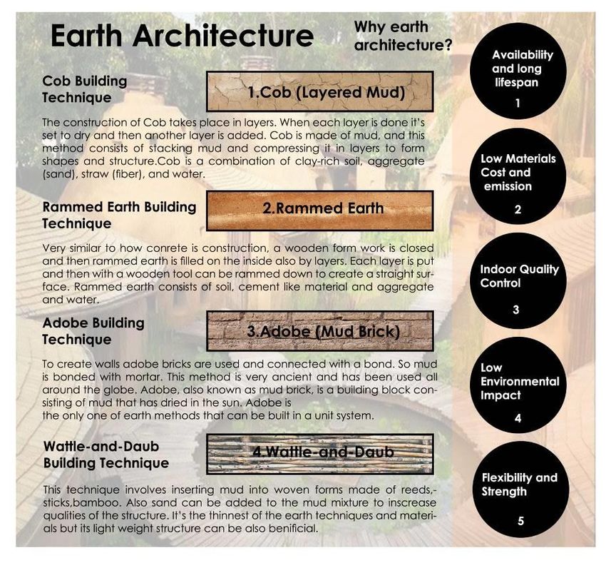
REVISITING PREHISTORIC ARCHEOLOGICAL SITES: ENVISIONING FIRST BUILT
ENVIRONMENTS TO REPOSSESS GEOGRAPHICALLY SPECIFIC APPROACHES IN
ARCHITECTURE

Abstract
Since Prehistoric times, architecture had been a human response to an occurring natural setting. Starting
from places of dwelling to buildings that no longer only serve physical requirements for survival.
Architectural languages were approached initially as an expression of culture, evolution, and growth
of a community within a natural setting. This response resulted in the creation of built environments,
humanity’s decision to become sedentary. This decision took place in the Late Stone age, a key phase in
our timeline. First built environments were born in a time known as the Neolithic revolution, which shown
itself as humans transitioned from hunter-gatherer societies to agrarian based ones. Once Nature shaped
man, now man shapes nature. We observe the dynamic created between man the hosting setting. While
observing this two sided complex operating system through revisiting prehistoric archeological sites, we
can notice how various geographic zones birthed a diversity of built environments. However, by observing
the paradigm of duality in our modern world, we can see neglected neighborhoods and cities, and more
importantly that we failed to fulfill our fair part of shaping our natural setting and this reflected on the state
of our communities as well. By repossessing how to be geographically specific in architecture, we can set
the parameters to architectural planning that includes nature as a co-partner and as a result attempt to
improve the well-being of our neglected communities.

Keywords
Prehistoric-Archeological Sites, Built-Environment, Geography, Archeology, Architecture.

      This article is available in BAU Journal - Creative Sustainable Development: https://digitalcommons.bau.edu.lb/
                                                                                                 csdjournal/vol2/iss2/5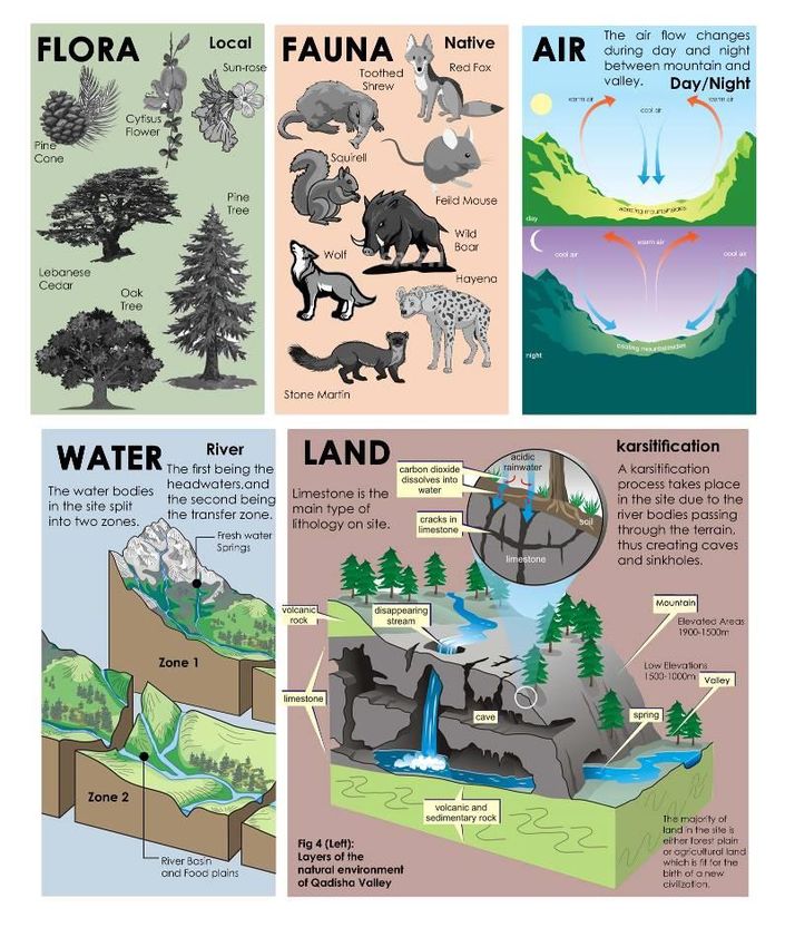
Abdulghany et al.: REVISITING PREHISTORIC ARCHEOLOGICAL SITES: ENVISIONING FIRST BUI

       1. INTRODUCTION
           ‘’The stone age is the longest period of human history, lasting from 2.6 million years ago to about
           5000 years ago. It is also the period of human history that is the least well known relative to late
           time periods. This period makes up almost 90% of our human history.’’ (Strom, C.2019)

                  In concept, little is known about the Stone age. Consequently, this allows us to underestimate
           the adapting capabilities our distant ancestors possessed. Even though the dwellers of that age didn’t
           have the technological advancements we have today, they managed to inhabit rawest natural
           surroundings. Therefore, allowing us to learn new lessons in sustainability. Our ancestors not only
           understood their natural setting but also communicated with it. More importantly they didn’t impose
           themselves as exploiters of the lands they inhibited but rather lived to be keepers and protectors of
           sacred forests and mountains. First built environments were birthed from the hosting landscapes,
           with each distinctive geography creating a human made setting in conjunction with its surrounding
           natural context.

            1.1 Research Approach
                         The combined research of archeological remains, anthropological aspects, and
                  geography presents a valuable study model for an in-depth envisioning of the dynamic
                  relation between human and natural setting that lead to the creation of the first built
                  environment and as a consequence an architectural response.
                         Despite how scarce physical traces remaining from that era are, we as a species haven’t
                  anatomically changed drastically since the late Stone Age. As distant as we may perceive
                  ourselves from our ancestors, the mutuality in the driving forces of our existence is evident.
                  Rather than two separate entities, modern and ancestral communities are a part of one
                  evolutionary process. The role of architecture has also undergone an evolving characteristic.
                  Worker’s accommodation, hunting stations, summer camps, temples, mortuary architecture,
                  and fortifications are all evident examples of architectural typologies being born from those
                  driving forces that we share till today. (Wilkins, H.2009)

            1.2 Problem Definition
                       Following the industrial age, we
                find that many of the driving forces that
                we encompass today have shifted to
                become materialistic, moreover we forget
                that the state of our existence also
                depends on the state of our natural setting
                and how we operate within it. Despite the
                architectural wonders we have erected in
                the best of our modern cities, we often
                detect neglected areas suffering from
                poverty and inequality in the same
                geographic zone.

                                                                                         Fig.2 (Right): War torn areas of
                                                          Fig.1 (Left): The glorious             Yemen and Syria
                                                              megacity of Dubai           Source: Ownership of UNDP
                                                       Source: Photograph by D. Cheons

                       The huge footprint of materialist based urbanization activities not only had led to the
                creation of class divided built environments that do not guarantee the well-being of its users
                but also affects natural contexts and their endemic eco-systems with threats of pollution and
                exploitation.

Published by Digital Commons @ BAU, 2021                                                                                    1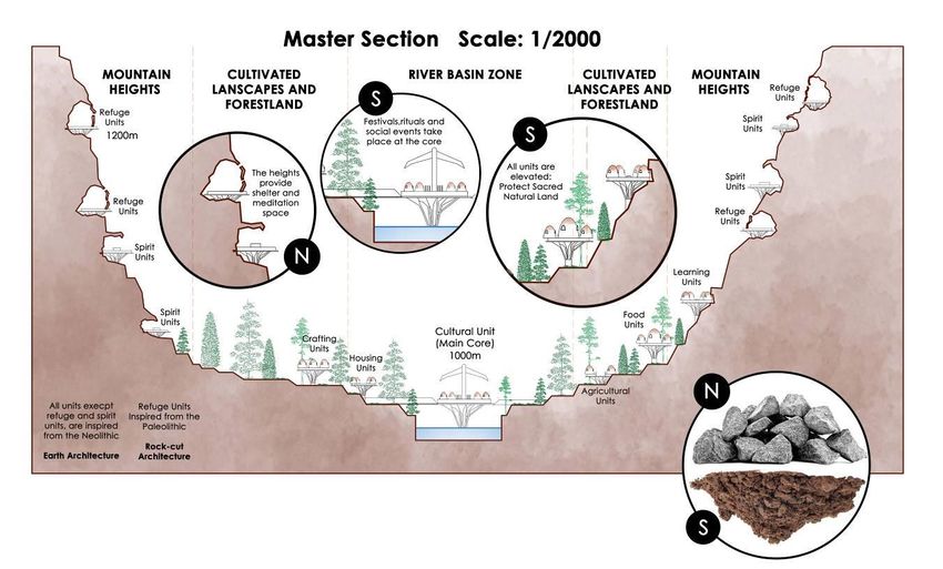
BAU Journal - Creative Sustainable Development, Vol. 2, Iss. 2 [2021], Art. 5

                       As an example we can observe the paradigm of socio-economic duality of our complex
                 modern world through a window to the middle east in which we find glorious megacities in one
                 side (As shown in Fig. 1), while finding war torn, poverty drenched areas in the other (As
                 shown in Fig. 2).

                        After the second world war, our understanding of architecture has transformed with the
                 spread of globalism. Unique architectural responses around the world were replaced with
                 monotonous concrete blocks. However, in the beginning such responses were a result of a long
                 trial and error based evolution humans have undergone in each distinctive geography (As
                 shown in Fig. 3).

                                         Fig.3 (a) Top: Materialism Based Architecture
                                     Fig.3 (b) Bottom: Geographically Specific Architecture
                          Source: Photographs from Order of Engineers seminar (Ownership of Arch. A.
                                                          Yeretzian)

https://digitalcommons.bau.edu.lb/csdjournal/vol2/iss2/5                                                         2
Abdulghany et al.: REVISITING PREHISTORIC ARCHEOLOGICAL SITES: ENVISIONING FIRST BUI

            1.3 Aim of Study
                       Starting from prehistory, built environments were originally a reflection of a given
                geographic context. Early architectural languages were approached initially as an expression of
                culture, evolution, and growth of a community within a natural setting. Many still existing
                vernacular masters pieces are the result of a long evolutionary path initiated by first Neolithic
                communities. ‘’This research aims to repossess geographically specific approaches in
                architecture, through envisioning the evolution of first built environments. In order to set
                the parameters to architectural planning that includes nature as a co-partner and as a
                result attempt to improve the well-being of our neglected communities.’’

            1.4 Research Hypothesis
                      With the paradigm of duality in our modern world at hand, it’s burdensome to propose a
                divergent outlook on architectural responses to growing megacities with consideration of the
                socio-economic complexities of our modern world. But what we can do is attempt to create a
                new approach to architectural planning in areas that are open to change and reconstruction. If
                equipped with all our collective knowledge we learn about past built environments that
                were in sync with local geographies, we can attempt to foresee a better future for the ones
                we have neglected.

            1.5 Research Determinants
                      This research intends to analyze the origins and evolution of built environments within
                natural settings in attempt to establish geographically specific approaches in architecture
                through a multi-disciplinary study involving archeology, geography, and anthropology
                embodied in architectural responses.

       2. LITERATURE REVIEW
                 We stumble upon numerous prehistoric archeological sites that witnessed the earliest
           examples of communal living and the birth of the first built environments during the late Stone Age.
           This event is known as the Neolithic Revolution. An event that has changed the trajectory of our
           evolutionary path forever. Taking place after the Younger Dryas (As shown in Fig. 5), a climatic
           episode in our human chapters that was almost cataclysmic with an Ice Age lasting a thousand years
           roughly between 12,900-11,800 years ago marking the end of the Pleistocene Epoch. After this
           climatic episode, change in the global climate and the populations of flora and fauna, triggered the
           human’s transition from hunter-gatherer societies to agrarian based ones.

            2.1 Prehistoric Archeological Sites
                       The Fertile crescent was the first
                geographic region to allow static living
                after the ice sheets of the late Ice Age
                starting melting (As shown in Fig. 4).
                Early humans were able to settle near
                nutritious rivers such as the Nile, Tigris
                and Euphrates allowing them to practice
                agriculture. Many of those sites such as
                Gobekli Tepe, Catalhuyuk, Jericho and
                many more are also classified by UNESCO
                as World Heritage Sites.

                                                                       Fig.4: Early Civilizations of the Fertile Crescent
                                                                               Source: Diamond, Jared (2012).

Published by Digital Commons @ BAU, 2021                                                                                    3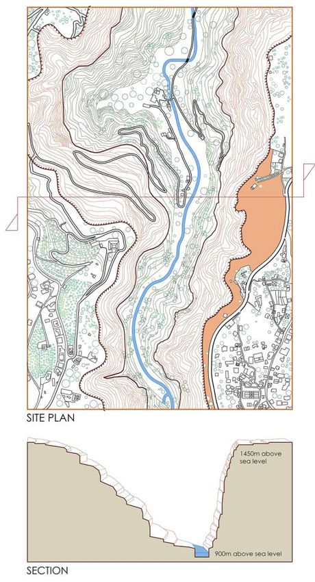
BAU Journal - Creative Sustainable Development, Vol. 2, Iss. 2 [2021], Art. 5

                A. Gobekli Tepe (Şanlıurfa, Turkey) Dating to 10000 B.C: World’s First Cultural
                   Building
                          Gobekli Tepe, also known as
                   potbelly hill, got its attention for
                   being the first non-domestic built
                   environment, this gives us an idea of
                   the birth of typologies in cultural
                   architecture demonstrated through
                   circular enclosures with limestone T-
                   shaped pillars covered with various
                   engravings of flora and fauna (As
                   shown in Fig. 7). This site was
                   discovered in 1994 by German
                   archeologist Klaus Schmidt. The site
                   is divided into three layers, layer I,
                   layer II, and layer III. The layers are
                   dated to the 10th millennium B.C.        Fig.5 (Top): The Younger Dryas Impact
                                                                   Source: The cosmic Tusk
                   The layers demonstrate how hunter-
                   gatherer societies built their first
                   buildings after the last Ice Age, which
                   started out as circular in plan in the
                   beginning, to shift later into
                   rectangular ones. The use of the
                   circular shape is more oriented
                   towards nature. (Schmidt, K.2011)
                                                                        Fig.6 (Bottom): Gobekli Tepe Physical location
                                                                                 Source: Knitter et al. (2019)

                    The Figures presented demonstrate how this area transformed after the last Ice Age. Hosting
                    the first agrarian societies.

                                                                                      Fig.7 (Top): T-shaped Pillar Art of
                                                                                               Flora and Fauna
                                                                                          Source: Schmidt, K.2011

                                                                                        Fig.8 (Left): Maps showing the
                                                                                         climate change in the region
                                                                                         Source: Knitter et al. (2019)

https://digitalcommons.bau.edu.lb/csdjournal/vol2/iss2/5                                                                    4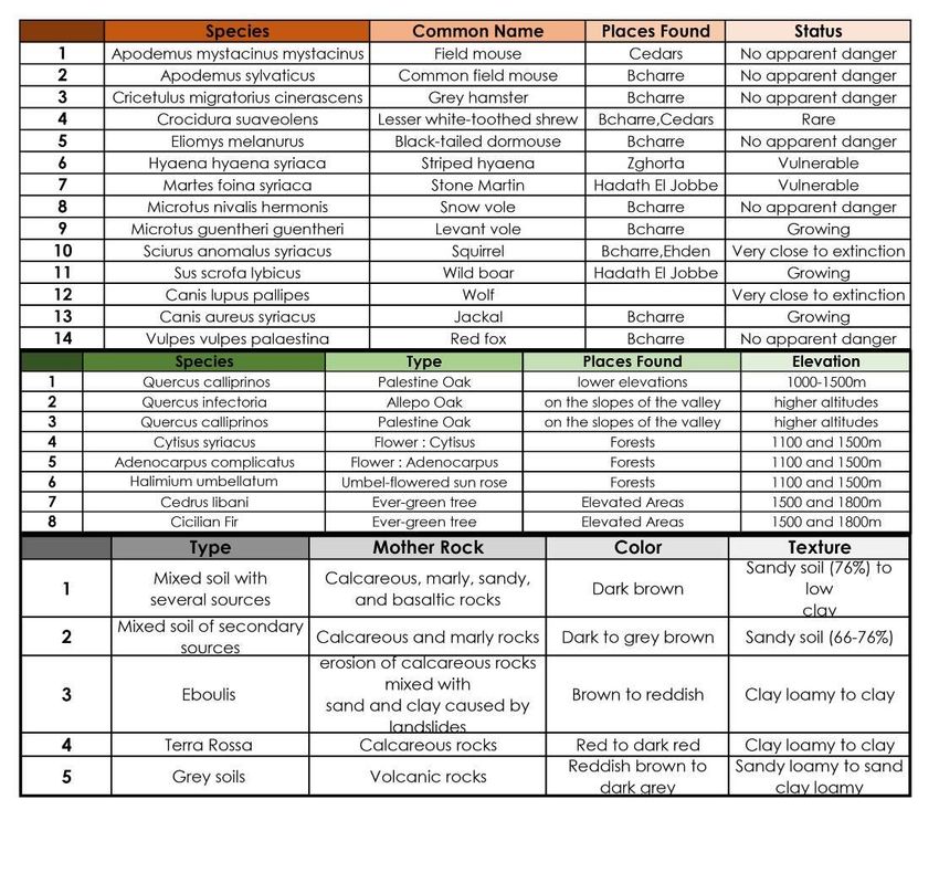
Abdulghany et al.: REVISITING PREHISTORIC ARCHEOLOGICAL SITES: ENVISIONING FIRST BUI

                                                                                              Fig.9: Gobekli Tepe
                                                                                              Reconstruction
                                                                                              Source: C. Atakuman,
                                                                                              (2014)

                                                                                              Fig.10: Gobekli Tepe
                                                                                              Reconstruction

                 Fig.11: Site Plan of Gobekli Tepe
                   Source: C. Atakuman, (2014)

               B. Çatalhöyük (Konya, Turkey) Dating to 7100 B.C: One of World’s First Cities
                        Discovered by James Mellart in 1960s, Çatalhöyük is mostly known for being one of
                 the world’s first cities. This city once hosted up to thousands of inhabitants, with an
                 interesting view on non-central urban layout in which each unit itself is multi-use. The
                 settlers of this area show an unusual mortuary habit of burying the deceased under the
                 flooring. How did the formation of such built environment take place?
                        Understanding the stages of erecting such city, it’s and adaptations is important to
                 visualize architectural interaction with the natural context. This area is situated at a high of
                 1000m above sea level, and on the south to the Taurus mountain range, the climate is semi-
                 arid (As shown in Fig. 13) The plateau is rich with diversity of flora and fauna. But the most
                 important feature is the adaptation those prehistoric architects invented, and that was creating
                 a city with no streets and horizontal axis, but rather transferring the urban space onto the roof,
                 and placing all entries on the upper level in adjustments to flood related scenarios. (Rosen, A.
                 and Roberts, N.2006)

                            Fig.12: Unit Reconstruction                  Fig.13: Climate Data on Prehistoric Catalhuyuk
                            Source: World Heritage Sites                           Source: D.Filipovic, (2017)

Published by Digital Commons @ BAU, 2021                                                                                  5
BAU Journal - Creative Sustainable Development, Vol. 2, Iss. 2 [2021], Art. 5

                                                                                                Fig.14: Geographic Map
                                                                                                of the region
                                                                                                Source: D.Filipovic,
                                                                                                (2017)

                                                                                                 Fig.15: House Unit
                                                                                                 Reconstruction
                                                                                                 Source: UNESCO

                               Fig.16: Site Plan
                          Source: D.Filipovic, (2017)

                                                                                        Fig.17: House Plan
                                                                                        Source: D.Filipovic,
                                                                                              (2017)

                                                                                     Fig.18: Catalhuyuk Reconstruction
                                                                                     Source: World Heritage
                                                                                     Sites

https://digitalcommons.bau.edu.lb/csdjournal/vol2/iss2/5                                                                 6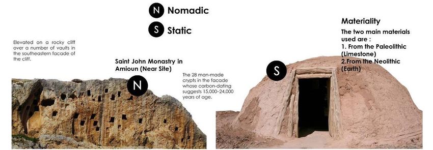
Abdulghany et al.: REVISITING PREHISTORIC ARCHEOLOGICAL SITES: ENVISIONING FIRST BUI

           C. Anthropology Within Natural Context
                    Looking back at our lost chapters of history it’s hard to
              tell what the social components of such distant communities
              were. Many Paleolithic cave art wonders leave us in mystery.
              What is evident nevertheless is that our ancestors like us
              experienced the unity and growth of their tribes into more
              complex communities with time. In attempting to find answers
              to such inquiry we can observe indigenous tribes. Indigenous is
              defined by oxford dictionary as: originating or occurring
              naturally in a particular place; native. Native communities are
              experts of the natural context they inhabit, and don’t impose
              themselves as exploiters of the lands but rather as keepers and
              protectors of sacred natural sites.

                                    Fig.19: Indigenous People                            Fig.20: Cave Art
                                   Source: National Geographic                          Source: Wikipedia

           2.2 Lessons Learned from Cultural Landscapes and Sacred Natural Sites
               A. Terminology
                        In 1992, the World Heritage Convention (UNESCO), established the term ‘cultural
                  landscape’ and contributed to its protection legally. The word culture comes from the Latin
                  ‘‘Colere’’ (colui, coltum) which means the cultivation of soil. This action is the first a
                  human does in a natural setting. While the word ‘‘Landscape’’ means to shape the land. The
                  concept of this term is mostly summarized in a balanced two party relationship: Human and
                  the natural setting. With previous prehistoric examples that are classified as ‘cultural
                  landscapes’, we can conclude that the influence of hosting geography played a vital role in
                  shaping the first built environment and as a consequence the human’s influence over nature
                  played a huge role in shaping the terrain. (UNESCO, 1992)

                                                  Fig.21: Cultural Landscapes
                                                       Source: UNESCO

Published by Digital Commons @ BAU, 2021                                                                        7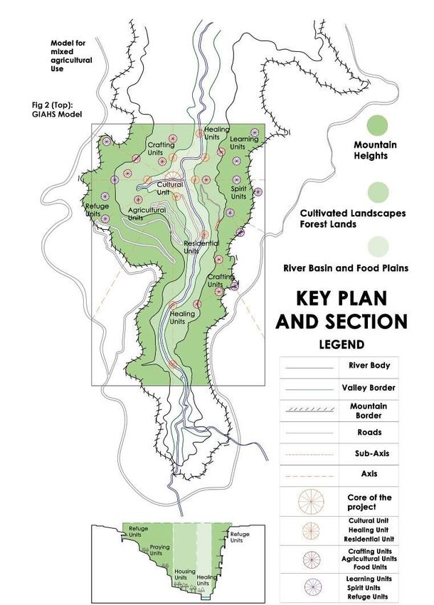
BAU Journal - Creative Sustainable Development, Vol. 2, Iss. 2 [2021], Art. 5

             B. Tangible and Intangible Values
                       From the Book ‘Conserving Cultural and Biological
                Bio-diversity: The Role of Sacred Natural Sites and Cultural
                Landscapes’ that clarifies UNESCO regulations in
                Indigenous areas. It’s also very important to consider the
                spiritual connection between man and the natural setting
                alongside the physical conditions. Cultural landscapes hold
                valuable knowledge of cultural sustainability. They are a
                great part of our collective identity. They are proof of the
                creativeness of the creator, in which both social and spiritual
                growth has contributed to shaping the land itself. With the
                limitless potential and technological tools at hand, and the                    Fig.22: Tangible and
                                                                                                 Intangible Values
                lessons learned from those unique sites, we can learn how to
                                                                                                 Source: UNESCO
                plan in accordance with nature in full context. (UNESCO
                Heritage Sites (Ed), 2006)

                                    Fig.23: Human and
                                    Nature interaction
                                    Source: A. Abdulghany,
                                    (2020).

                                    Fig.24: Cultural and
                                    Natural Value
                                    Source: UNESCO

              C. Linking Tangible and Intangible Values
                       The 7th session of the book discusses the applications performed in linking tangible and
                 intangible values. With all the knowledge at hand we can take a more holistic approach
                 towards sustainability. An approach that embraces the spiritual as well as the social, economic
                 and scientific realms of our communities. One of the examples emphasizes on the addition of a
                 sacred dimension into the planning of natural sites such as Pachamama, known as the mother
                 of earth in Inca culture. In perceiving nature, mountains and rivers are also foreseen as
                 intangible sacred entities as well as tangible geographic features. Some of those applications
                 include:

                                                                                 a. Continuity of original oral
                                                                                    traditions,      languages    and
                                                                                    expressions.
                                                                                 b. Performing social practices,
                                                                                    rituals and festive events.
                                                                                 c. Gathering of knowledge of nature
                                                                                    and eco-systems.
                                                                                 d. Practice of local craftsmanship
                                                                                    and agro-pastoral activities.
                                                                                 e. Protection of natural sites.

                                                                                  Fig.25: Linking Tangible and
                                                                                  Intangible values
                                                                                  Source: UNESCO

https://digitalcommons.bau.edu.lb/csdjournal/vol2/iss2/5                                                                8
Abdulghany et al.: REVISITING PREHISTORIC ARCHEOLOGICAL SITES: ENVISIONING FIRST BUI
D. Globally Important Agricultural Heritage Systems
The term was initially created by the Food and Agriculture Organization of the United
Nations. (GIAHS) are landscapes that combine a wide range of bio-diversity as well as cultural
heritage. This approach involves the implementation of a set of features and processes that
allow a landscape to conserve its endemic eco-systems as well as serve as a source of life for
the inhabiting communities. The approach involves the revival of agro-pastoralism in which a
combination of various crop and livestock production activities rather than the exploitation of
one particular species. Some of those activities include beehives farming alongside fruit trees
for example. Neglected communities affected by poverty and inequality have been for years
performing such activities in their local habitats, therefore this can serve as a successful and
low cost operating system in geographically specific architectural planning and serve as an
empowering force for such communities
Fig.26: GIAHS
Model
Source: World Food
and Agriculture
Organization
Fig.27: Agriculture in
Neglected Communities
Source: FAO
2.3 Built Environment
Built Environment can simply be defined as
‘’man-made structures, features, and facilities
viewed collectively as an environment in which
people live and work.’’ (Definition from Oxford
Dictionary).
In the book ‘Introduction: Definition, Design,
and Development of the Built Environment Part 1’
it is mentioned that the components that make up a
built environment start from the needs of humans as
well as thoughts and actions. When those actions are
well planned, this reflects on the quality of life, and
when the opposite is done uncomfortable situations
are created.
Fig.28:
Comfortable Built
Environment
Source: P. Vink,
(2016)
Fig.29: Elements of the Built
Environment
Source: Lynch, (1960).
Published by Digital Commons @ BAU, 2021 9BAU Journal - Creative Sustainable Development, Vol. 2, Iss. 2 [2021], Art. 5
2.4 Geographically Specific Approaches in Architecture
In a published research with the title of ‘Geo-archaeology of Phoenicia’s buried harbors:
Beirut, Sidon and Tyre 5000 years of human-environment interactions’ (Geomorphology.
Université de Provence) a study was done to uncover the dynamic relation between human and
his natural setting. By monitoring the changes that occur through a timeline of 5000 years in
the coastlines of Lebanon the researcher was able to identify the effect of human sedimentary
activities on chosen landscapes.
Geo-archeology would include the study of archeological remains with a reference to
geological, geographic, and natural characteristics. It’s very essential to establish the main
defining points of this dynamic interaction. (Marriner, Nick,2007).
A. Geographical elements of a natural environment:
In any region of earth, the elements of a natural context geographically speaking are the
same. They are made of the following:
a. Flora: All plant and tree species.
b. Fauna: All animals
c. Air: Climate, Airflow
d. Water: Rivers, waterfalls, sea, ocean etc.
e. Land: Valleys, mountains, deserts etc.
Each of those elements can serve as a decision supporting tool for future architectural
planning, from considerations related to the building itself and within it as well as outward
to the natural context.
B. Approaches Towards a Better Future for Neglected Communities
Geographically specific Approaches in Architecture are seen in passive, vernacular,
earth and sustainable architecture. All of those styles encourage the use of approaches that
do earth no harm, as well as the fundamental understanding of how to exist within a natural
setting. Most known pioneers in this field are Hasan Fathy, Nader Khalili, and Frank Lloyd
wright. In a materialist world, economy dictates the well-being of a community. Areas
affected by poverty, inequality and destruction are the most to pay the price. Reconstructing
those areas can be done through the implementation of geographically specific approaches
in architectural planning of the chosen built environment. Economically speaking, the
construction of such spaces and areas is on the lowest side of cost. Providing the poorest
communities, the chance to create such habitat. Earth architecture technologies and
materials that can create a low cost and easy to construct solution. With the ease of
construction, the users of the spaces themselves can play a major role in the creation of their
new home.
2.5 Down to Earth: A New History of Raw Earth Architecture
Building with earth has been around for thousands of years, ever
since the prehistoric times. Today those methods are being revived. In the
past we find many built environments created with merely the earth on site
with remarkable consideration to the natural surroundings. A great example
is the still existing vernacular town on Sanaa, Yemen. Showing us the
ability to respond to population needs through multi-story building as well.
Fig.30: Sanaa, Yemen
Earth Architecture
Source: S. Zuhairy
https://digitalcommons.bau.edu.lb/csdjournal/vol2/iss2/5 10Abdulghany et al.: REVISITING PREHISTORIC ARCHEOLOGICAL SITES: ENVISIONING FIRST BUI
By observing the
multi-stored marvel of
earth architecture in
Sanaa of Yemen, we
can start visualizing a
different future for the
sake of our built
environments. This
example proves that
earth architecture, an
approach very much
geographically specific
if combined with
modern tools can
respond to our current
issues.
Fig.31: Earth
Architecture Study
Source: A. Abdulghany,
(2020).
A. A Hundred Classrooms for Refuge Children – Nader Khalili
Architecture Is A Human Right
The Late Nader Khalili, an Iranian
born architect, author, humanitarian and
teacher is best known for providing shelter
in the developing world and emergency
contexts through the use of earth
architecture. The philosophy of the project
emphasizes on the idea of building for
refugees and by refugees in the area of Tell
Zaatari refugee camp in Jordan. A
philosophy that can serve as a suitable
solution for the recovering of affected
communities.
Fig.32: Gallery of Pictures
Source: Arch Daily
Published by Digital Commons @ BAU, 2021 11BAU Journal - Creative Sustainable Development, Vol. 2, Iss. 2 [2021], Art. 5
B. Home for Homeless Children- Volontariat
Another example portrays the various ways
earth architecture can be combined with recycling
strategies and thus creating a hybrid responding
to both low cost requirements and pollution
disadvantages. The building complex is built in
Podincherry in India by the NGO Volontariat.
Fig.33: Gallery of Pictures
Source: Archnet
2.6 Parameters of Analysis
The following parameters serve as design supporting tools in geographically specific
approaches in architecture:
Table 1 : Parameters of Analysis
Tangible Values Intangible Values
Local vegetation and trees Eco-system preservation
Flora Agricultural Activities Art inspired from Plants and Trees
Endemic Species Patterns and shapes
Local animal species Eco-system preservation
Fauna Animal husbandry and livestock Folk stories and tales
Endemic Species Animal considering infrastructure
Ventilation considerations Spaces and buffers
Air Thermal Comfort Social Activities
Renewable energy Rituals and Festivals
Irrigation and water resource Sacred Entities: Rivers, Waterfalls
Water Water Quality and management Cleansing rituals
Renewable Energy Conservation
Material for construction Agro-pastoral activities on site
Land Land covers and types Road patterns and connections
Topography and geology Urban planning
Socio-economic needs Belief Systems and religion
Human Physiological needs Behavioral Patterns
Cultural needs Backgrounds and Heritage
3. METHODOLOGY
In this paper, four types of research methodology were used. The first method is the inductive
method, which consists of a gathering and presenting of data concerning the chosen case study;
‘Qadisha Valley’. This data is composed of environmental studies to fully understand the given
natural context. Topographic and geographic studies are performed as well as a part of
understanding the physical state of the valley. As well as a historical study, which presents the
archeological excavation taken place at the chosen site, and how both states of static and nomadic
https://digitalcommons.bau.edu.lb/csdjournal/vol2/iss2/5 12Abdulghany et al.: REVISITING PREHISTORIC ARCHEOLOGICAL SITES: ENVISIONING FIRST BUI
existence is found at the site. The second method, field methodology consists of the photographs
and notes taken by the author after performing site visit combined with a questionnaire that was
distributed on a sample of specialists in the field over the study of the dynamic relation between
man and the natural context since its beginning. The third method, analytical method will include
analysis of the given data, as well as a performed analysis of the results given by the questionnaire.
Finally, in the deductive method, as a combination of all methods and extracting conclusions and
the process of deduction of geographically specific approaches in architecture for creating a better
built environment within the natural context. Those four mentioned methods are presented in the
research as follows.
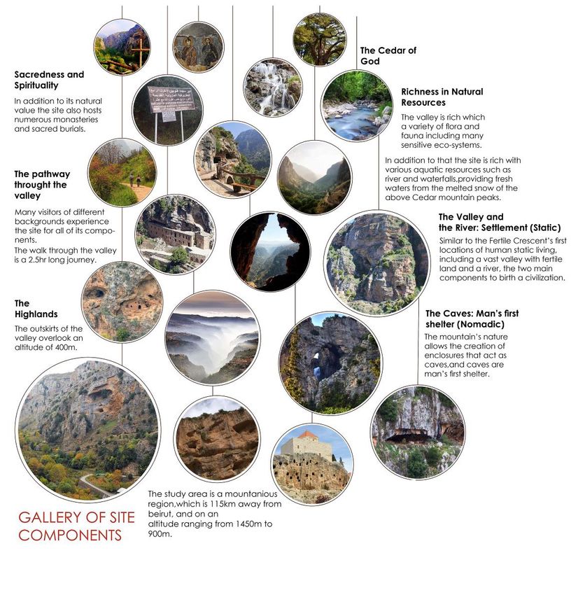
3.1 Introducing the Case Study of ‘Qadisha Valley’ in Lebanon
Site Selection
Qadisha Valley holds one of the many undiscovered earliest settlements of Neolithic
peoples, the Natufians. Those peoples are one of the first proto civilizations that emerged right
after the human’s transition from hunter-gatherer societies to agrarian based ones. In the
chosen site, we find a natural context that has its unique tangible and intangible values
qualifying it to be classified as a cultural landscape and a World Heritage Site by UNESCO.
This can serve as a virtual study model for the in-depth envisioning of the dynamic between
human and natural setting. With collective knowledge and technological tools and parameters
at hand we can create a draft for geographically specific architectural planning to learn lessons
that can be at aid in responding to our current difficulties in the built environment.
The study area is considered a mountainous region, which is 47 km away from Tripoli at
the coast and about 115 km from the Capital Beirut. The study area could be divided into two
topographic layers:
• The Valley: This layer includes the Valleys of Qadisha and Qanoubine including the
Qadisha river, it has an altitude ranging from 900 to 1400 m.
• Elevated Areas: This layer includes the mountain ranges. This part has an altitude range
between 1400 to 1900 m.
Fig.34: Map of Lebanon
Source: Wikipedia
Published by Digital Commons @ BAU, 2021 13BAU Journal - Creative Sustainable Development, Vol. 2, Iss. 2 [2021], Art. 5
3.2 Archeological Study
Traces of the Natufian people, one of the first
sedentary cultures in the Levant and the world were
found in the region (As show in Fig. 37). The
excavations were performed under the title of ‘Qadisha
Prehistoric Project’ from 2004-2008. A group of caves
was studied with activity dating back to 20000 years
ago, thus allowing us to have a sample of the Paleolithic
living (Hunter-gatherer) and Natufians (First agrarian
societies). The site is also rich with more recent heritage
value of the followers of the Abrahamic faiths with
many religious buildings, saints, and sacred burials. The
site was used as a refuge for believers escaping
persecution, as well as it being a renowned pilgrimage
destination as well as a great attraction of tourists and
nature lovers. Fig.36: Qadisha Valley
Source: G. Per
Fig.37: Map of Natufian Dwellings
Fig.35: Archeological Data Source: A. Gorring Morris, (2013).
Source: Garrard, A., & Yazbeck, C. (2005)
3.3 Visualizing the Geography
Creating a virtual model for study with all of the available data concerning all aspects of
the chosen geography can be a great aid in creating a simulation for future geographically
specific architectural planning. A set of studies of the environment and the geographic area
were performed by the UNESCO and the JICA group. The goal of the study was to help
develop and improve the chosen area. The studies done by the organization is a valuable asset
in the research of the given site. By understanding all the various elements of the area and the
site we can start to set a more proper foundation for laying down conclusions.
https://digitalcommons.bau.edu.lb/csdjournal/vol2/iss2/5 14Abdulghany et al.: REVISITING PREHISTORIC ARCHEOLOGICAL SITES: ENVISIONING FIRST BUI
Fig. 38: Qadisha Valley
3d Reconstruction
Source: A. Abdulghany,
(2020)
Fig.39: Site Plan and Section
Source: A. Abdulghany, (2020)
Fig.40: Weather Data
Source: JICA,
UNESCO
Fig.41: land cover Map and
Location of Sensitive Eco-systems
Source: JICA, UNESCO
Published by Digital Commons @ BAU, 2021 15BAU Journal - Creative Sustainable Development, Vol. 2, Iss. 2 [2021], Art. 5
Fig.42: Tables Showing Natural Data
Source: JICA, UNESCO
Fig.43: Elements of the
Given Geography
Source: A. Abdulghany,
(2020)
https://digitalcommons.bau.edu.lb/csdjournal/vol2/iss2/5 16Abdulghany et al.: REVISITING PREHISTORIC ARCHEOLOGICAL SITES: ENVISIONING FIRST BUI
3.4 Linking Tangible and Intangible Values- Qadisha Valley
From the 8th session of ‘Conserving Cultural and Biological Bio-diversity: The Role of
Sacred Natural Sites and Cultural Landscapes’ that clarifies UNESCO regulations in
Indigenous areas, Qadisha Valley is suggested as an example in the process of linking tangible
and intangible values as well as ways of managing of an Associative Cultural Landscape
(World Heritage Site Classification). The proposed suggestions are as following. (UNESCO
Heritage Sites (Ed), 2006)
a. Creation of cultivated terraces (Agro-Sylvo-Pastoral Activities)
b. Combining agricultural traditional activities with the Mediterranean geography.
c. Management and conservation of sensitive eco-systems and endangered endemic species.
d. Dividing intro zones of forest populations and zones of agro-sylvo-pastoral activities.
e. Preserve cultural heritage from prehistoric adaptations to religious asylum seeks of
Abrahamic faiths.
f. Revive the use of the local ancient Syriac languages.
g. Preservation and management of soil.
Fig.44: Gallery of Components
Source: A. Abdulghany, (2020)
Published by Digital Commons @ BAU, 2021 17BAU Journal - Creative Sustainable Development, Vol. 2, Iss. 2 [2021], Art. 5
3.5 Site Visit
A site visit was performed in the attempt
to physically experience the given natural
context, in which both nomadic hunter-gatherer
dwellers in caves and static agrarian societies in
the valley existed. By visualizing both settings
we can get a better view of the transition humans
took thousands of years ago.
• First observation: Existing signs indication
the locations of the burials of sacred persona.
• Second observation: Despite the municipal
effort to conserve the area, the site has
witnessed vandalism actions and lacks
management.
• Third observation: Some of the existing built
structures such as roads with vehicular
movement lead to the killing of a unique
reptilian species.
• Fourth observation: High-lands of Paleolithic
Cave Dwelling (Nomadic). Fig.45: Site Visit Pictures
• Fifth Observation: Low-lands of Neolithic Source: A. Abdulghany, (2018)
Sedentary activities (Static).
3.6 Questionnaire
An anonymous questionnaire was designed and distributed on 100 educated people of
archeologists, historians, anthropologists, geologists, architects. The questions tackled
questions related to the knowledge of prehistoric sites and the transition humans took. The
questions were as following:
1) As a history researcher, can you say that previous events and cycles repeat? (Yes,
No,Other)
2) What other than geographic conditions triggered the human to become sedentary and
transition from hunter-gatherer societies to agrarian based ones? (Short Answer)
3) If sedentary activities were triggered by the convenient natural conditions, can the
opposite ( Cataclysmic events, Near extinction level events, etc..) turn us back into
nomadic hunter-gatherer like societies again? (Yes,No,Other)
4) In your opinion, were the first built environments geographically specific?
(Yes,No,Other)
5) From archeological findings and recorded activity during the stone age, can you say
humans were more aware of the natural setting? (Yes,No,Other)
6) In a site like Catal Huyuk, a decentralized urban layout was used without any emphasis
on specific buildings, does that imply the absence of social hierarchy in first societies?
(Yes,No,Other)
7) In your opinion, can the social structures of the indigenous tribes be considered a
valuable study model linking us with our forgotten ancestral social structure?
(Yes,No,Other)
8) In your opinion, what was the building typology of Gobekli Tepe? (Ceremonial Site,
Temple, Astronomical Observatory)
9) Can architecture benefit from the study of those stone age sites in finding more
harmonious languages in building within nature? (Yes,No,Other)
10) What were the most frequently used materials and building technologies used in stone
age human-made surroundings? (Long Answer)
https://digitalcommons.bau.edu.lb/csdjournal/vol2/iss2/5 18Abdulghany et al.: REVISITING PREHISTORIC ARCHEOLOGICAL SITES: ENVISIONING FIRST BUI
Some of the responses to the given questions were as following:
1) ‘Maybe because our evolution does not have a strictly linear path, that's why it feels like
repeating.’
2) ‘It wasn't an event. It was a long transitional process influenced by a number of factors’
3) ‘The scarcity of resources due to increasing population accompanied with a larger rage
of diversification in mass wants and needs’
4) ‘Only if population levels drop precipitously’
5) ‘No because the knowledge we acquired over the years helps us to steps ahead’
6) ‘They were picked based on critical trial and error experiences, so yes they were specific
and appropriate.’
7) 64% replied ‘Yes’, 36% replied ‘No’
8) ‘Yes, it gives off a reassurance that human tribes were like an extended family;
commonly used spaces and a built environment that behaved like a home.’
9) 68% replied ‘Yes’, 32% replied ‘No’
10) ‘Maybe they approached all the above as one idea.’
11) ‘Indeed it can!’
12) ‘clay and straw’
13) ‘I do believe they had more technologies than we think but regarding the materials I
think they built with local materials’
3.7 Findings
In a raw natural setting such as Qadisha Valley, the site visit provided a closer look into
the circulation patterns found in a natural setting. With mountainous elevations reaching up to
3000m above sea level and deep valley enclosures reaching down to 1000m above sea level,
we can experience a different perception of our human scale. The lower a visitor descends into
the valley, the more micro he/she will feel. The existence of forest land, wetlands, terraces and
elevated lands allows us to plan updated circulation patterns that include the various layers of a
geography as well as existing eco-systems.
Furthermore, from the questionnaire we can conclude that humans were more aware of
their natural setting, even though different from our perception today. Moreover, in order to
survive the rawest natural settings, humans adapted by noticing and interacting with each and
every aspect of the natural context. Primarily climate resulted in the transition from nomadic to
static, yet we can’t underestimate the human factor when built environments were created. It’s
a process initiated by convenient natural conditions infused with human emotion, evolution,
and increased population. Yet it’s time we re-evaluate this relation, we are visitors on this
planet and not exploiters of the lands we inhibit.
Published by Digital Commons @ BAU, 2021 19BAU Journal - Creative Sustainable Development, Vol. 2, Iss. 2 [2021], Art. 5
3.8 Discussion
Now that we can visualize
the geography with all of its bio-
diversity, and also have
acknowledged the tangible and
intangible values, we can start
planning the virtual study
simulation in which clusters of
units are proposed to be situated
depending on the function and
activities of each unit as well as
its location in terms of
geographical and natural context.
With addition to the application
of the GIAHS model of mixed
agriculture (As shown in Fig.47).
Fig.47: GIAHS Model for the Given
Geographic Region Fig.46: Key Plan and Section
Source: FAO Source: A. Abdulghany, (2020)
Fig.48: Proposed Program
Source: A. Abdulghany, (2020)
By applying the parameters of analysis of geographically specific architecture we can
formulate a program that responds to all of the existing geographic layers as well as the
tangible and intangible values of the cultural landscape. In future planning, many tools such as
GIS and virtual reality can help us not only bring those natural contexts to life virtually but also
to make use of all available data related to the natural conditions for geographically specific
approaches in architecture.
https://digitalcommons.bau.edu.lb/csdjournal/vol2/iss2/5 20Abdulghany et al.: REVISITING PREHISTORIC ARCHEOLOGICAL SITES: ENVISIONING FIRST BUI
Fig.49: New Inspirations from the Old
Source: A. Abdulghany, (2020)
Fig.50: Master Section
Source: A. Abdulghany, (2020)
4. CONCLUSION
As we are reaching the dawn of the age of information, despite all technological
advancement and progress, we find ourselves stranded further away from our natural setting.
The effects of the following have contributed to the depletion of earth’s natural resources,
destruction of valuable eco-systems, and the weakness of our communities in both the health
aspect and the social aspect.
In planning our future, with all the knowledge we possess and the technological tools,
we can find various ways in shaping our future built environments and reviving the ones we
have neglected. Perhaps finding a new holistic approach to sustainability in which even the
most marginalized communities can be a part of is as essential as all of the previous attempts
made in that area. These approaches not only can eliminate inequalities and raise communities
from poverty, but also allow us to imagine an alternative future in which architectural planning
of our built environments that is in conjunction with the hosting natural context.
Published by Digital Commons @ BAU, 2021 21BAU Journal - Creative Sustainable Development, Vol. 2, Iss. 2 [2021], Art. 5
REFERENCES
− Bar-Yosef, O., & Valla, F. R. (2013). Natufian Foragers in the Levant: Terminal Pleistocene
Social Changes in Western Asia (International Monographs in Prehistory: Archaeological
Series, 19) (1st ed.). Berghahn Books.
− Benjamin, David & Ap, T. (2006). Resources for Sustainable Architecture from Historic,
Ancient, and Indigenous Knowledge, presented at the Rethinking Sustainable Construction
Conference, 2006, The Rinker School of Construction and Environment.
− Garrard, A., & Yazbeck, C. (2005). The Revival of Prehistoric Field Research in Lebanon: The
Qadisha Valley Prehistory Project. Near Eastern Archaeology, 68(4), 193–194.
− Goring-Morris, A. N., & A. Belfer-Cohen. 2013. Ruminations on the role of periphery and
centre for the Natufian. In O. Bar-Yosef & F. R. Valla (eds.), The Natufian Foragers in the
Levant. Terminal Pleistocene Social Changes in Western Asia. Pp. 562-583. International
Monographs in Prehistory, Archaeological Series 19, Ann Arbor.
− Hodder, I., & Marciniak, A. (2017). Assembling Çatalhöyük RPD (Themes in Contemporary
Archaeology) (1st ed.). Routledge.
− Işık, Ayşe & Tulbentci, Tugsad. (2008). Sustainable housing in island conditions using Alker-
gypsum-stabilized earth: A case study from Northern Cyprus. Building and Environment, 43.
1426-1432. 10.1016/j.buildenv.2007.06.002.
− Kloukinas, Dimitrios 2015. Neolithic building technology and the social context of
construction practices: the case of northern Greece. PhD Thesis, Cardiff University.
− Lawrence, D., & Low, S. (1990). The Built Environment and Spatial Form. Annual Review of
Anthropology, 19, 453-505. Retrieved November 25, 2020.
− Marriner, Nick. (2007). Geoarchaeology of Phoenicia's buried harbours: Beirut, Sidon and
Tyre 5000 years of human-environment interactions.
− Rosen, A. and Roberts, N. (2006) The nature of Çatalhöyük: people and their changing
environments on the Konya Plain. In: Hodder, I., (ed.) Catalhoyuk Perspectives: reports from
the 1995-99 seasons. Çatalhöyük Research Project (6). McDonald Institute for Archaeological
Research, Cambridge, UK, pp. 39-53.
− Sadowski, Ryszard. (2017). Neolithic Revolution. 10.1007/978-94-007-6167-4_540-1.
− Schmidt, K. (2011). Göbekli Tepe – the Stone Age Sanctuaries. New results of ongoing
excavations with a special focus on sculptures and high reliefs. Documenta Praehistorica,
37(0), 239.
− UNESCO Cultural Heritage Sites (Ed.). (2006). Conserving cultural and biological diversity:
the role of sacred natural sites and cultural landscapes (8997th ed.).
− Walsh, K. (2013). The Archaeology of Mediterranean Landscapes: Human-Environment
Interaction from the Neolithic to the Roman Period. Cambridge: Cambridge University Press.
− Wilkins, H. (2009). The Evolution of the Built Environment (BAR International Series).
British Archaeological Reports.
https://digitalcommons.bau.edu.lb/csdjournal/vol2/iss2/5 22You can also read