SITKA'S SHORT-TERM TOURISM PLAN - DRAFT PLAN FOR PLANNING COMMISSION 12.15.21 CITYANDBOROUGHOFSITKA,ALASKA ADOPTIONPLANNEDFORJANUARY2022
←
→
Page content transcription
If your browser does not render page correctly, please read the page content below
SITKA’S SHORT-TERM
TOURISM PLAN
DRAFT PLAN FOR PLANNING COMMISSION 12.15.21

City and Borough of Sitka, Alaska   Adoption Planned for January 2022
ACKNOWLEDGMENTS

     Planning Commission                                      Assembly
      Chris Spivey, Chair                            Steven Eisenbeisz, Mayor
   Darrell Windsor, Vice Chair                       Kevin Knox, Deputy Mayor
           Stacy Mudry                            Kevin Mosher, Vice Deputy Mayor
        Wendy Alderson                           Thor Christianson, Planning Liaison
            Katie Riley                                    Crystal Duncan
                                                        Rebecca Himschoot
                                                             David Miller
                                                       Valorie Nelson (former)

                                      Staff
                      John Leach, Municipal Administrator
                     Michael Harmon, Public Works Director
            Melissa Henshaw, Public & Government Relations Director
                Antonio Rosas, Harrigan Centennial Hall Manager
                          Stan Eliason, Harbormaster
                        Melissa Haley, Finance Director
                           Robert Baty, Police Chief
                           Craig Warren, Fire Chief
                           Grant Turner, IT Director

                                Planning Team
                          Amy Ainslie, Planning Director
                              Ben Mejia, Planner I

OUR THANKS
The Planning Team would like to extend our gratitude to all those in the community
who have participated in the formation of this plan. From our City and Borough co-
workers, tribal representatives, Visit Sitka, the Ports and Harbors Commission,
visitor industry experts, local businesses, community organizations, local news
outlets, state agencies, and involved citizens, your contributions are deeply
appreciated.

A special thank you is extended to the Planning Commission, who worked many
long evenings to steer this planning effort and see it to completion.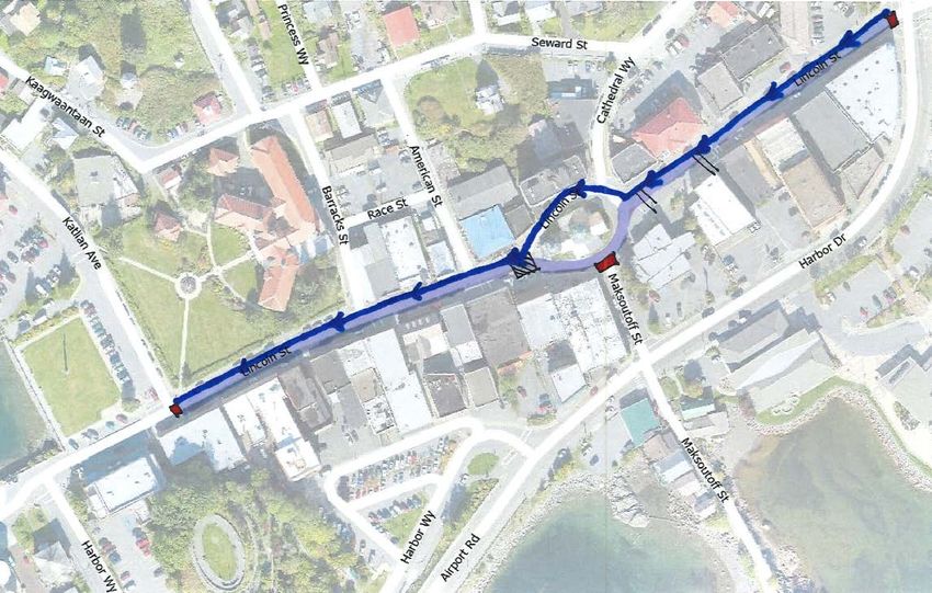
TABLE OF CONTENTS
        I. CONTEXT AND PLANNING HORIZON                         5
              Changes to the Cruise Visitor Industry in Sitka   5
              Assembly and Planning Commission Action           5
              Public Engagement                                 6
              Meeting Dates and Topics                          6
        II. DISPERSION                                          7
              Drop-off and Avoidance Points                     7
              Findings                                          9
              Recommendations                                   9
        III. TRANSPORTATION                                     10
              Visitor Transportation                            10
                   By Land                                      10
                   By Sea                                       10
              Resident Transportation                           11
                   Bike and Pedestrian Commuting                11
                   Public Transit                               11
                   Parking Solutions                            11
              Findings                                          12
              Recommendations                                   12
        IV. TRAFFIC                                             13
              Halibut Point Road and Sawmill Creek Traffic      13
                   Dock to Downtown                             13
                   Sawmill Creek Road Project                   13
              Emergency Service Access                          14
              Downtown Traffic                                  14
                   Lake/Lincoln/Harbor Drive Intersection       14
                   Lincoln Street                               15
                   Harrigan Centennial Hall                     23
              Findings                                          29
              Recommendations                                   29
        V. Infrastructure & Future Planning Needs               30
              Direct-use Infrastructure                         30
              Indirect-use Infrastructure & Resources           33
              Future Planning Needs                             33
              Findings                                          33
              Recommendations                                   34
        VI. Action Compilation                                  35

SHORT-TERM TOURISM PLAN                                              3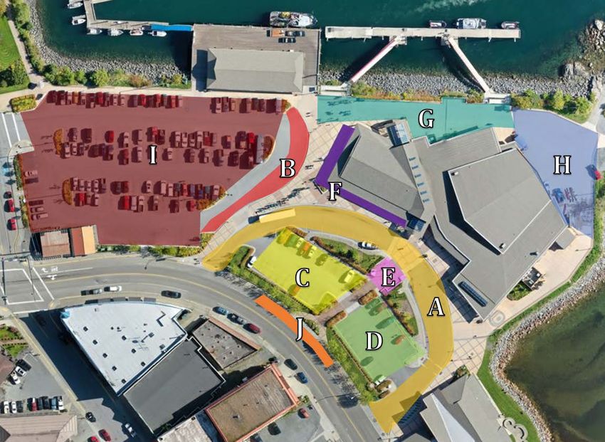
GLOSSARY OF TERMS AND ABBREVIATIONS
ADOT                         Alaska Department of Transportation
Attraction, excursion        Destinations, guided tours, and experiences available to visitors
CBS                          City and Borough of Sitka
                             Transportation system to move passengers in mass from SSCT to the
Dock-to-downtown shuttle
                             downtown area via large passenger buses
HCH, Centennial Hall         Harrigan Centennial Hall
HPR                          Halibut Point Road
LOS                          Level of service
ROW                          Right-of-way
Seawalk                      The pedestrian path stretching from HCH to the National Historic Park
SMC                          Sawmill Creek Road
                             Sitka Sound Cruise Terminal, the privately-owned and operated cruise
SSCT
                             ship dock located at 4513 Halibut Point Road

APPENDIX
•   2022 Sitka Cruise Calendar provided by Cruise Line Agencies of Alaska on November 29, 2021
•   Sidewalk Level of Service Classification from the Journal of Engineering Research and Studies

SHORT-TERM TOURISM PLAN                                                                              4
I.         CONTEXT AND PLANNING HORIZON
CHANGES TO THE CRUISE VISITOR INDUSTRY IN SITKA

In spring of 2021, it was announced that Sitka is expected to receive its largest cruise visitor season
on record in 2022 with 400,000 passengers anticipated. This forecast was increased to 480,000
during the summer months, with estimates for 2023 and beyond ranging from 500,000 – 520,000.

Sitka’s largest cruise season on record was in 2008 with approximately 285,000 passengers. Not only
is the increase to 480,000 passengers a significant increase over this previous high, the logistics of
cruise ship visitation in Sitka has changed with the opening of the privately owned Sitka Sound Cruise
Terminal (SSCT).

Before the development of SSCT, cruise ships anchored offshore and would lighter passengers into
town, coming directly to Crescent Harbor dock and the O’Connell Bridge dock. From these locations,
passengers would disperse to town on foot, on pre-booked tours, or by other modes of transportation
available at the docks. Given its location approximately five miles away from the downtown area,
passengers now disembarking at SSCT are shuttled to Harrigan Centennial Hall via ~60 passenger
buses as the primary means of transportation. However, some tour operators do pick-up and/or drop-
off guests directly from SSCT, making it another dispersion point in addition to Centennial Hall.

These changes in the industry prompted the creation of this plan.

ASSEMBLY & PLANNING COMMISSION ACTION
On April 13, 2021, the Assembly and the Planning Commission held a joint work session to discuss
the scope and deliverables of this plan. It was determined that the plan would have five main
elements:

                                                                 INFRASTRUCTURE        FUTURE PLANNING
    DISPERSION          TRANSPORTATION           TRAFFIC
                                                                      NEEDS                 NEEDS

 Keep passengers        Explore options for    Manage traffic       Define CBS            Outline future
 moving throughout        passenger and          to ensure         infrastructure      planning needs for
 town and prevent            resident           safety and       needs for the 2022    CBS infrastructure
    congestion            transportation        efficiency             season         and community-wide
                                                                                            impacts

The planning horizon was to be for the next one to five years, with a heavy emphasis on the 2022
season. It was agreed that outreach would be vital; a broad approach including industry
professionals and organizations, merchants, tour operators, and the general public should be part
of the process. To this effect, a work plan and schedule was developed and utilized for the
planning effort.

SHORT-TERM TOURISM PLAN                                                                                   5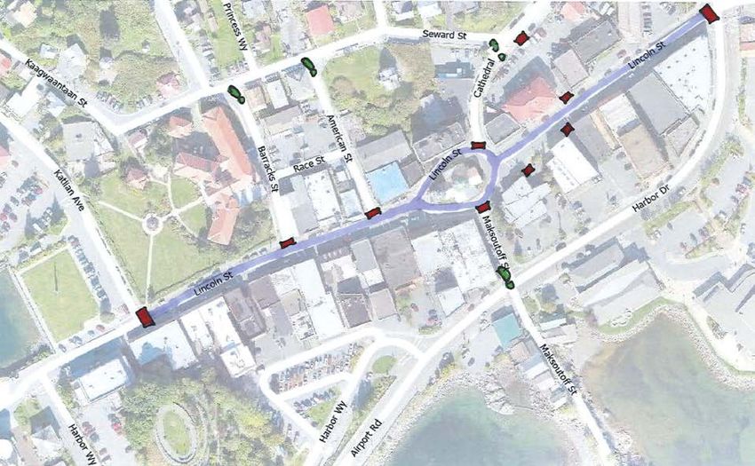
PUBLIC ENGAGEMENT

            All meetings of the Planning Commission were open to the public, with in-person and
            Zoom options made available. An email list was compiled by canvasing the downtown
            area, utilizing list serves maintained by Visit Sitka, and continual advertising of this
            option throughout the process. The email group had over 125 members and was notified
            of all upcoming meetings and plan updates. Newspaper, radio, and social media were
            also utilized to advertise meetings and opportunities for plan participation. A community
            survey was available from December 17 – January 9.

MEETING DATES & TOPICS

  Date              Body                                           Topic
3/9/21                                Assembly provided direction to staff and the Planning
                  Assembly            Commission to develop the plan
4/13/21      Assembly & Planning      Joint Work Session between the Assembly and Planning
                 Commission           Commission to develop the scope and deliverables of the plan
5/5/21                                Introductory session with Planning Commission to review
             Planning Commission
                                      work plan and schedule and outline data/research needs
5/19/21      Planning Commission      Commission review of plan for Forums
5/20/21      Planning Commission      Attraction and Excursion Forum
6/2/21       Planning Commission      Public comment on passenger dispersal
6/3/21       Planning Commission      Downtown Business Forum
6/16/21                               Background information review of the Sitka Gateway Plan
             Planning Commission      (1998), the Transit Services Contract, CPET fund use
                                      guidance, and the 2022 preliminary cruise calendar
7/7/21       Planning Commission      Dispersion wrap-up and review of input from Forums
7/21/21      Planning Commission      Transportation alternatives
8/4/21                                Traffic from dock to downtown, Sawmill Creek Road Project,
             Planning Commission
                                      and Lake/Lincoln/Harbor Drive intersection
9/15/21                               Downtown traffic and congestion mitigation – public input
             Planning Commission
                                      and problem identification
10/6/21                               Centennial Hall traffic and staging – public input and problem
             Planning Commission
                                      identification
10/13/21       Ports & Harbors        Centennial Hall traffic and staging – Commission input and
                Commission            problem identification
10/20/21                              Analysis and recommendations for Lincoln Street traffic
             Planning Commission
                                      presented
11/3/21      Planning Commission      Direct-use infrastructure needs
11/10/21        Ports & Harbors       Analysis and recommendations for Centennial Hall traffic
                 Commission           and staging presented
11/17/21                              Analysis and recommendations for Centennial Hall traffic
             Planning Commission
                                      and staging presented
12/1/21      Planning Commission      Indirect infrastructure impacts and future planning needs
12/15/21     Planning Commission      Presentation of draft plan
1/13/22      Assembly & Planning      Joint work session to review draft plan and make
                 Commission           suggestions for final draft
1/19/22      Planning Commission      Recommendation of plan for adoption
1/25/22           Assembly            Plan adoption

SHORT-TERM TOURISM PLAN                                                                            6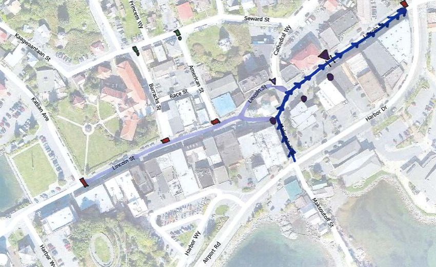
II. DISPERSION
Downtown merchants, attraction and excursion operators, tourism industry representatives, and the
general public were engaged to discuss the need for passenger dispersion, particularly on large ship
days. “Large ship days” were defined as days with more than 6,000 passengers.
The latest preliminary 2022 cruise calendar was provided by Cruise Line Agencies of Alaska on
November 29, 2021. Of the 159 days of the season (first sailing April 28th and last sailing is October
3rd), this is the breakdown of passenger loads:
Number of Cruise
Number of Days in Season Percent of Season
Passengers
0 21 13%
1-999 30 19%
1,000 – 2,999 37 23%
3,000 – 5,999 47 30%
6,000 – 8,000+ 24 15%
The full calendar is provided in the appendix and color coded to correspond with the levels in the
table above.
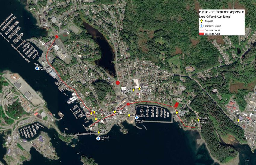
DROP-OFF AND AVOIDANCE POINTS
Participants were asked to identify ideal locations to direct and/or drop-off passengers, as well as
areas to avoid.
Drop-off points largely centered around locations near the downtown area including Harrigan
Centennial Hall, the Library, the O’Connell Bridge dock, Totem Square or Totem Square Inn, the
Katlian Avenue area including the Community House, Baranof Playground, Totem Park, and the
Sitka Sound Science Center. It was also recommended that more dispersion points along Sawmill
Creek and Halibut Point Road be developed in addition to attractions such as the Alaska Raptor
Center and Fortress of the Bear.
Avoidance points for pick-up/drop-off that were generally agreed upon were Katlian Avenue (i.e. that
this street should not be used to divert bus traffic from other streets as it is already congested, but
that visitation to attractions and historical sites in this area should continue to be encouraged),
residential areas, the Fine Arts Camp portion of the Sheldon Jackson Campus, and anywhere with
traffic devices (near intersections, roundabouts, traffic lights, etc.).
Drop-off/pick-up on Lincoln Street and in front of St. Michael’s Cathedral was contended. While some
advocated that this would bring visitors directly into the high-demand areas for shopping or site
seeing, others felt that congestion on Lincoln Street should not be exacerbated.
While lightering/water taxiing was considered as a part of dispersion conversation, later discussions
on transportation (see section III, Transportation) more fully analyzed the challenges associated with
this type of operation. A map showing all drop-off and avoidance points as discussed was produced.
SHORT-TERM TOURISM PLAN 7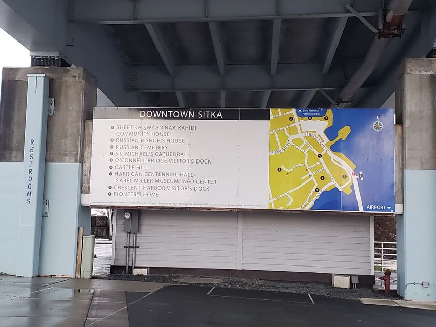
SHORT-TERM TOURISM PLAN 8
Public comment was also received during the Traffic section of the plan that additional attractions on
Halibut Point Road should be considered in order to add more dispersion points. In particular, a
suggestion was made that low-impact development in the No Name Mountain area for recreational
use could benefit visitors and locals alike.

FINDINGS

   1. Quality of experience matters – too many passengers downtown or at any one attraction/site
      at once can detract from the quality of the passenger’s experience.

   2. Cruise passengers should continue to be encouraged to come downtown for shopping and
      dining, seeing historic and culturally significant sites/attractions, and to recreate along the
      Seawalk and at the National Historical Park.

   3. High quality, high visibility signage is needed to effectively disperse passengers dropped off in
      the downtown area.

   4. Other means of communicating visitor information should be improved to keep things moving
      smoothly, particularly on large ship days. Particular areas of improvement include local
      communications of the cruise calendar and potential changes in traffic, a digital guidebook/site
      or app, shore-ex support at the dock and drop-off points, and training for bus drivers.

   5. As visitor numbers grow, more attractions and excursions will be needed to meet demand and
      effectively disperse passengers throughout town.

   6. Implementation of a looping shuttle system had both advocates and opponents.
         a. Pro: A shuttle system would be an effective means of transporting passengers
            throughout town and address mobility issues many passengers may experience.
         b. Con: A public and/or free shuttle system would negatively impact private industry
            transportation providers.

RECOMMENDATIONS

   1. While the dock-to-downtown shuttles will continue to bring passengers to Centennial Hall as
      their main drop-off and pick-up point, utilization of alternative drop-off points for tour operators
      and other transportation providers should be encouraged.

   2. Commission large-scale signage to be strategically placed at major drop-off points.

   3. Implement a mobile app and/or QR code system to assist with wayfinding and visitor
      information access conditional upon addressing limitations of cell and internet service.

   4. Encourage growth of the attractions and excursions market.

   5. Encourage development of a looping shuttle system and investigate ways to work with private
      industry transportation providers for public/private partnership opportunities.

SHORT-TERM TOURISM PLAN                                                                                      9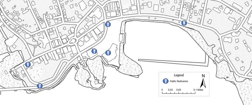
III.      TRANSPORTATION
VISITOR TRANSPORTATION

BY LAND
             Currently, the transportation of passengers from the SSCT dock to the downtown area
             (referred to as “dock-to-downtown shuttling”) takes place via large buses with capacities
             ranging from approximately 48 to 60 passengers. Buses depart from the SSCT every
             15 minutes, travel along Halibut Point Road to Lake Street, and continue through the
             traffic light at the Lake/Lincoln/Harbor Drive intersection to arrive at Centennial Hall.
             From this point, passengers can walk to shopping and other attractions/destinations in
             the downtown area, meet their pre-booked tour, or purchase a tour/transportation
             offered for sale at Centennial. When they wish to return to SSCT, passengers come
             back to Centennial Hall to catch a departing shuttle. Some tour operators pick up
             directly from SSCT and will drop passengers off downtown, or back at SSCT directly.

Since 2013, CBS has entered into a Transit Services Contract to provide a subsidy of the dock-to-
downtown shuttling operation using the Commercial Passenger Excise Tax revenue. The most recent
contract for 2020 and 2021 provided a subsidy in the amount of $1.07/passenger transported.

Considerable public interest for electrification of the large-scale visitor transportation services was
voiced during the planning process. Concerns with the currently utilized diesel buses included the
associated noise, air pollution, and carbon emissions. Industry representatives cited high investment
costs (with estimates of $750,000 - $1,000,000 per bus of commiserate size) and lack of charging
stations as the main barriers to conversion in the short-term.

BY SEA

               In the beginning stages of plan development, the concept of lightering/water taxi service
               to transport passengers from SSCT to the downtown area was discussed as a method
               of alleviating bus traffic and congestion on the road system. However, several
               challenges became apparent:
   •   A water taxi service would likely not be a profit-making operation as currently envisioned.
   •   Space at the SSCT dock is limited.
   •   Available locations that would bring passengers into downtown (primarily the O’Connell Bridge
       Dock or Crescent Harbor) would result in a lengthy ride due either to the required slow speeds
       travelling through the breakwater and Sitka Channel, or the added time diverting around the
       breakwater/channel via Western Channel and Middle Channel. Therefore, moving a significant
       enough number of passengers to meaningfully decrease bus transportation would require a
       large water taxi fleet both in terms of the size of the vessels as well as the number of vessels.
   •   The only identified dock facility that could work on the water transportation side (in terms of
       decreasing trip length) was the North Plant for Petro Marine. However, there is not adequate
       upland space for bus transportation that would be needed. Further, this would add significant
       bus traffic on Katlian Ave. which is already congestion-challenged.

SHORT-TERM TOURISM PLAN                                                                               10
RESIDENT TRANSPORTATION
Given the limitations of Sitka’s road system and available public parking in the downtown area,
impacts to the ease of resident transportation are inevitable with the growth of cruise passenger
visitation. Multi-modal transportation offers potential to increase capacity of our existing infrastructure
while reducing burdens to individual pieces of the transportation system. Three main areas were
addressed as potential means of mitigating these impacts.
BIKE AND PEDESTRIAN COMMUTING
Members of the public identified bicycle and pedestrian transportation as a
means of alleviating downtown traffic and parking pressures. Creation and
support of incentive programs were suggested to encourage participation.
Additional bike shelters or racks downtown should be considered if incentive
programs are pursued. While walking/biking may not be viable transportation
alternatives for all, any alleviation of vehicular traffic and parking demand is
beneficial and should be encouraged.
PUBLIC TRANSIT
Public transit is an integral component of multi-modal transportation system,
enabling transportation for those without personal vehicles and offering an
alternative to those who may wish to decrease personal vehicle reliance. Sitka’s
public transportation systems such as the RIDE and Care-a-Van should continue
to be supported and opportunities to encourage ridership explored.
PARKING SOLUTIONS
Where possible, additional parking is needed in the downtown area for those
who live, work, worship, shop, and recreate downtown. Private property owners
are encouraged to open any available parking, and opportunities to maximize
existing public parking should be pursued. Another suggested solution was a
Park and Ride system wherein vehicles could be left at a larger lot outside of the
downtown area, and a bus would run regularly between the vehicle parking and
downtown. Increased enforcement of public parking regulations would also
ensure that parking is being utilized as intended and prevent abuse/misuse of
publicly available parking.
SHORT-TERM TOURISM PLAN 11FINDINGS
1. There is ample community interest in seeing electrification of bus fleets, particularly for large-
scale transportation services. However, the high investment costs and lack of charging
infrastructure present major hurdles for conversion to take place in the near term.
2. Similarly, water taxi services face investment and logistical challenges that make it an
unsuitable transportation alternative in the near future. However, this may be a more feasible
option in the future if a bus-accessible location were to be developed north of the Sitka
Channel.
3. Multi-modal options and parking solutions are critical to meet resident transportation needs.
RECOMMENDATIONS
1. Encourage and incentivize bicycling and walking as alternatives to vehicular transportation in
order to decrease vehicular traffic congestion and alleviate parking pressure in the downtown
area. CBS could partner with existing community organizations that promote walk and bike
initiatives. Further, additional bike racks and/or shelters should be considered in the downtown
area.
2. Long term, CBS should consider incentive structures that would encourage fleet electrification,
particularly for dock-to-downtown shuttling services, and explore opportunities for installation
of charging stations.
3. Opportunities to incentivize alternative transportation modes for residents should be pursued.
Additionally, parking solutions such as expansion of parking in the downtown area or a Park
and Ride arrangement will be needed as the visitor industry continues to grow.
SHORT-TERM TOURISM PLAN 12IV. TRAFFIC
HALIBUT POINT ROAD AND SAWMILL CREEK ROAD TRAFFIC
DOCK TO DOWNTOWN – HALIBUT POINT ROAD
On August 4th, representatives from ADOT joined the Planning Commission to discuss traffic along
HPR and expected impacts resulting from both the increase in cruise visitor related traffic and
developments along HPR such as growth of amenities at SSCT, the new Cross Trail connector in this
area, and the adventure park at 4951 HPR. Suggestions from the public and the Commission fit
largely into two main categories:
Pedestrian safety improvements: With increased traffic on HPR, more crosswalks
(particularly lighted crosswalks) are desired to make street crossings safer. Suggested
locations include the new Cross Trail connector across the street from 4951 HPR, the
Seamart/Cascade Creek Road intersection, and at Brady Street (particularly in light of
increased SEARHC development in this area). Further, development of a dedicated
pedestrian path is desired between SSCT and the adventure park/Cross Trail
connector. These latter attractions would also benefit from large, clear signage.
Beautification/visitor enhancement: Beautification projects along the HPR/Swan Lake
sidewalk corridor and at the roundabout were suggested, with ideas ranging from
painting/murals, signage, or banners. Development of additional attractions on HPR
were also discussed (see section II. Dispersion).
Without supporting data from a traffic study, the justification for ADOT to make these changes will be
difficult to substantiate. CBS and ADOT should continue to collaborate on traffic safety needs and
work towards getting a traffic study for Sitka in the near future.
SAWMILL CREEK ROAD PROJECT
ADOT will be performing significant road work on Sawmill Creek Road in the summer of 2022
between the roundabout and the Sitka National Cemetery. The scope of the project includes
stormwater infrastructure improvements, resurfacing, development of a new bus stop, and pedestrian
safety improvements. While these improvements are certainly needed and will be of great community
value, the construction season overlaps with the visitor season. SMC Road is a critical arterial right-
of-way for traffic flow and its closure will significantly impact traffic efficiency.
Commission discussion and public comment emphasized the challenges most detour routes would
present. Many large vehicles/equipment will struggle to use smaller collector and minor streets given
narrowness and tight turns. There was also concern for traffic being diverted into residential
neighborhoods which would exacerbate existing traffic speed/congestion problems.
While the traffic control plan (TCP) for the project will not be developed until a contractor is selected
to execute the project, CBS and ADOT representatives have met to discuss some preliminary
guidance a TCP should include. If the TCP includes use of CBS rights-of-way for detouring, CBS
must first provide approval. CBS will continue to advocate that, to the greatest extent possible, traffic
SHORT-TERM TOURISM PLAN 13flow be maintained at least one-way (outbound) through the project area before CBS rights-of-way
are approved as detour routes.
EMERGENCY SERVICE ACCESS
Proximate to the SSCT, the Sitka Fire Department would like to stage a small ATV ambulance that
can be available for calls to the cruise ships or to the adventure park under development at 4951
HPR. The ATV ambulance itself will not be staffed or stocked for budget and security reasons. An
ambulance will respond to calls in this area and go to the ATV ambulance first – crew will load in with
kits and a gurney and will be directed to the patient from there. The ATV ambulance will then be used
to transfer the patient into the full-sized ambulance for transportation to the hospital/other medical
services.
The Police and Fire Departments were both included in planning for downtown traffic to ensure that
any closures or changes in traffic pattern would not complicate emergency access. The Fire
Department plans to continue responding from the Fire Department, sending ambulances to the
nearest street or alley to the call, sending in crew, gurney, and equipment to meet the patient and
wheeling back to ambulance. Any improvements of traffic flow in the downtown area, particularly
decongestion of the Lake/Lincoln/Harbor Drive Intersection and alleviating left-turn traffic into
Harrigan Centennial Hall, will benefit speed and accessibility for emergency services.
DOWNTOWN TRAFFIC
LAKE/LINCOLN/HARBOR DRIVE INTERSECTION
The intersection of Lake Street, Lincoln Street, and Harbor Drive appears to be the biggest bottleneck
for downtown traffic flow. Vehicles turning left from Lake Street on to Lincoln Street do not have a
dedicated turn lane or traffic control signal, and significant traffic flow from Japonski Island and that
exiting the downtown area can make this turn difficult to make. Under these conditions, a few
vehicles waiting to make this left turn can back traffic up to the roundabout which has domino effects
for HPR and SMC traffic flow. In addition to the “left turn” issue, this intersection handles significant
pedestrian crossing as well, which reduces the efficiency of vehicular traffic flow. Three
mitigations/solutions were suggested:
Left turn lane, Lake to Lincoln: Having a dedicated left turn lane for Lake to Lincoln
traffic flow could improve efficiency of the intersection, allowing straight-through and
right-turn traffic to move independent of left-turn traffic. This could be accomplished with
restriping.
Traffic conductor: Many members of the public recalled summer seasons in which a
traffic conductor was stationed at this intersection to improve traffic flow. A well-trained
traffic conductor can be more capable of adjusting and responding to real-time
demands as opposed to the automated signal system. A traffic conductor could also
enable implementation of the next suggestion.
All-cross: Instead of timing pedestrian traffic crossings with the vehicular signaling,
some communities utilize an “all-cross” system in which all pedestrians waiting to cross
can do so at once, regardless of which corner they are at. Diagonal movements are
often permitted as well, cutting down on the number of crossings needed. No vehicular
traffic can move at this time, but it removes pedestrian crossing as a delay during
vehicular movement.
SHORT-TERM TOURISM PLAN 14LINCOLN STREET
The section of Lincoln Street from Lake Street to Katlian Avenue contains the majority of downtown
retail stores, restaurants, churches, and historic sites. This area is beloved by locals and visitors alike
for its authentic, small-town feel. Given its importance, discussion of plans for Lincoln Street took
place throughout the planning process.
A level of service (LOS) analysis was completed to better understand the capacity limitations of the
pedestrian space on Lincoln Street. As listed on the table below, different levels of service indicate
the speed, freedom of movement, and likelihood of pedestrian-to-pedestrian collisions.
• LOS A indicates total free movement, at any speed, and almost no likelihood of bumping into
another person.
• LOS F is akin to a people slowly shuffling in a queue, with no freedom to choose speed or
direction of movement. Even at this extremely low level of service, the sidewalk space on
Lincoln Street can only accommodate about 1600 pedestrians.
• Higher levels of service providing a more pleasant pedestrian experience are only possible in
the 500-800 pedestrian range.
After reviewing the level of service analysis, it became apparent to the Planning Commission that
sidewalk space alone on this stretch of Lincoln Street cannot comfortably support our forecasted
visitor numbers. The full description of each level of service is available in the appendix.
Lincoln Street Assumptions for LOS Analysis
Driving Lane Width (x2) 12 ft.
Parking Lane Width (x2) 8 ft.
Sidewalk Width (x2) 5 ft.
Length of Street 1,300 ft.
Total Square Footage 65,000 s.f.
Pedestrians supported at each LOS
Total
pedestrian LOS A LOS B LOS C LOS D LOS E LOS F
S.F. available
No closure –
13,000 213 317 520 813 1,444 1,625
sidewalk space only
Staff reviewed and analyzed several options; some were options proposed in the Gateway
Plan and others were a result of public comment/staff generation – all are described and
detailed below. The first five options presented were studied, but ultimately not recommended
by staff for consideration. Staff review included Planning, Public Works, Police, and Fire
departments. Recommended options start on page 19.
SHORT-TERM TOURISM PLAN 15Studied Options - Not Recommended
Gateway Plan Option 1
Pros
• Maintains vehicular access to downtown amenities
• Could maintain downtown parking
Cons
• Funnels traffic to substandard routes (Seward &
American)
• Does not make optimal use of Harbor Drive
• Does not create more space for pedestrians on the
west end of Lincoln where more is needed
• Would be confusing as a temporary solution (i.e. if not
in place consistently day-to-day during the season or as
a built design)
Gateway Plan Option 2
Pros
• Maintains vehicular access to downtown amenities
• Could maintain downtown parking
• Removes traffic from in front of St. Michael’s
Cons
• Funnels traffic to substandard routes (Seward &
Cathedral, American & Barracks). Cathedral Way lacks
adequate width to be two-way without major
redesign/loss of parking
• Does not make optimal use of Harbor Drive
• Does not create more space for pedestrians on the
west end of Lincoln where it is needed
• Would be confusing as a temporary solution (i.e. if not
in place consistently day-to day during the season or as
a built design)
SHORT-TERM TOURISM PLAN 16Gateway Plan Option 3
Pros
• Maintains vehicular access to downtown amenities
• Could maintain some downtown parking
Cons
• Funnels traffic to substandard routes (Seward &
Cathedral). Cathedral Way lacks adequate width to be
two-way without major redesign/loss of parking
• Does not work well as a temporary (rather than built)
solution – traffic would have to cross lanes and go the
“wrong way” around the church.
• In order to keep Cathedral, American, and Barracks
open, traffic would have to cross pedestrian spaces
which can exacerbate bottlenecks at these intersections
Overall, the downtown traffic designs as proposed in the Sitka Gateway Plan are more suited to
permanent/built alterations of streets and traffic flows in the downtown area as opposed to temporary
solutions created with signage, barricades, cones, etc. None are suitable for regular mobilization and
demobilization if flexibility based on daily passenger count is desired.
Staff considered ways that the Gateway Plan recommendations could be modified to better suit a
temporary/short-term option. Those concepts are presented on the next page, though neither are
recommended options.
SHORT-TERM TOURISM PLAN 17Modified Gateway Options 1 and 2
Pros
• Maintains vehicular
access to bank drive-thrus
• Could maintain some
downtown parking
• Opens pedestrian space
on the west end of Lincoln
Cons
• Adds left-turn traffic to
Lake/Lincoln intersection
• Intensive to mobilize and
demobilize regularly
Modified Gateway Option 3
Pros
• Maintains vehicular
access on bank drive-thru
and pharmacy side of street
• Maintains some downtown
parking
• Opens pedestrian/
amenity/vending space in
west bound lane
Cons
• Adds left turn traffic at
Lake/Lincoln intersection
• More streets (Cathedral,
American, Barracks) either
need to be closed or will
have to cut across
pedestrian space
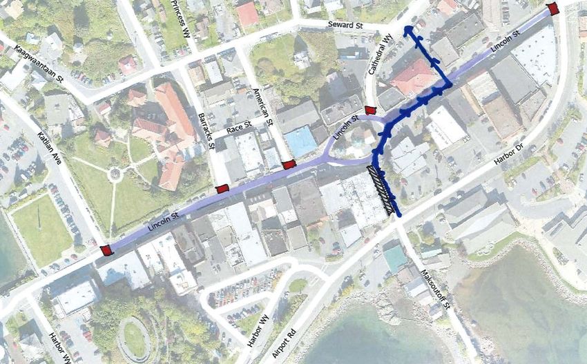
SHORT-TERM TOURISM PLAN 18Studied Options - Recommended
Full Closure Option
Description
• Lincoln Street is closed to vehicles from the Lake/Lincoln Intersection to the Lincoln/Katlian
Intersection
• Feeder routes (Barracks, American, Maksoutoff, Cathedral, and other unnamed alleys)
blocked from entry
• Closures could be on a consistent schedule (M-F) or based on daily passenger count
Pros
• Allows maximum pedestrian space and clearly separates pedestrians from vehicles
• Opens maximum spaces for amenities (benches, water stations, garbage cans, potentially
vending, etc.)
• Equitable for both ends/sides of Lincoln Street merchants/entities
Cons
• Maximum loss of parking
• Maximum impact on vehicular access to locally demanded services (primarily pharmacy and
bank drive-thrus)
• Complicates Pioneer Home emergency access
• Necessitates new downtown stop for The Ride
• Congestion remains around Totem Square/end of Lincoln
SHORT-TERM TOURISM PLAN 19One-Way Option
Description
• Lincoln Street remains open to vehicular traffic one-way westbound
• Pedestrian space and amenity/vending staging can take place in the eastbound traffic/parking
lanes. Amenities/vending could potentially be staged for the whole season. This would
decrease labor needs for daily mobilization/demobilization and allow locals and independent
travelers to partake in off-hours
• “Vehicle crossing designations” available at bank drive-thrus
• A temporary median would be needed to separate pedestrians and vehicles
• Pull-in parking spaces designated near churches
• Would be in place all season (too labor/storage intensive to mobilize/demobilize daily)
Pros
• Allows more vehicular access to Lincoln Street while reducing pedestrian and vehicle conflict
• Maintains vehicular access to downtown amenities & use of bank drive-thrus
• Lower loss of parking
• Provides for better emergency access to Pioneer Home
• Possible reduction in jaywalking due to median barriers
Cons
• Less space opened for pedestrians and other amenities
• Vehicles and pedestrians still intermingled to some degree
• Necessitates new downtown stop for The Ride
• Congestion remains around Totem Square/end of Lincoln
• North side of street gets vehicular access but less pedestrian space, vice versa for the south
SHORT-TERM TOURISM PLAN 20A Hybrid Option was also proposed as a recommended option. Lincoln could be fully closed when needed (perhaps based on passenger volume) but staged to re-open as the One-Way Option. This would allow for amenities and potential vending to be staged in the east bound lane for the whole season and not have to demobilize when the street is reopened. This provides more flexibility to accommodate moderate and high passenger count days. However, it comes with the pros and cons of both options when in place and would be more labor intensive than the One-Way Option alone. A Full Closure Modification was also sketched to address accessibility for bank drive-thrus. The design below allows one-way traffic up Maksoutoff St., in part of the eastbound lane of Lincoln, and then directs traffic up the unnamed alley between 315 and 321 Lincoln. This would create proper vehicle alignment to utilize all three of the downtown bank drive-thrus, accommodate for ADA access from Lincoln Street, and it would also open the opportunity to add pull-in parking along Maksoutoff Street in the unused lane. However, the crossing from the eastbound lane to the westbound lane to access the alley will be difficult to design. Traffic movement onto Seward Street will increase use of the uncontrolled intersection at Seward and Lake Streets, while not included in the plan recommendations, a traffic conductor may be needed if this option is selected. The level of service analysis was then updated to include the two main recommended options along with a comparison matrix. SHORT-TERM TOURISM PLAN 21
Pedestrians supported at each LOS
                           Total
                        pedestrian        LOS A       LOS B   LOS C    LOS D     LOS E      LOS F
                       S.F. available
No closure –
                           13,000           213        317     520       813      1,444      1,625
sidewalk space only
Full Closure Option        65,000          1,066      1,585   2,600     4,063     7,222      8,125

One-Way Option             39,000           639        951    1,560     2,438     4,333      4,875

                                     Option Comparison Matrix

Factors                    Full Closure Option                  One-Way Option

Parking                    Highest impact on parking            Moderate impact on parking

                           Highest impact on vehicular          Lesser impact on vehicular
Convenience                access to downtown retail            access to downtown retail and
                           and services                         services
                           Best separation of vehicles          Some intermingling of vehicles
Pedestrian Safety
                           and pedestrians                      and pedestrians

                           Maximum pedestrian and               Moderate pedestrian and
Visitor Experience
                           amenity space                        amenity space

                           Very labor intensive for set-
                                                                Needs most equipment for
Logistics                  up and take down on a
                                                                temporary medians/fencing
                           daily/weekly basis
                           Provides flexibility to be fully     Has to stay in place season-
                           open in off-hours/days and           long – too labor and storage
Flexibility
                           change with passenger                intensive to demobilize
                           levels                               regularly

                           No opportunity to                    Opportunity to permanently
                           permanently stage                    stage amenities/vending for full
Amenities/Vending
                           amenities/vending for                season and offers off-hour
                           season                               enjoyment opportunities

   Comparative Advantage        Comparative Disadvantage

After consideration of these options and hearing public comment, the Planning Commission voted 4-1
to recommend the Full Closure Option from 10am to 4pm on days with 3,000 or more cruise
passengers with the stipulation that efforts to find downtown parking solutions be prioritized.

SHORT-TERM TOURISM PLAN                                                                              22
HARRIGAN CENTENNIAL HALL
Harrigan Centennial Hall (HCH) has long served as our main “hub” for cruise ship passengers given
its proximity to Crescent Harbor (which was the main lightering facility when ships largely anchored
offshore) and use as a visitor center. Since the development of SSCT, HCH has continued to serve
as a hub for cruise passengers, shifting its function to become, in part, shuttle bus terminal. It’s
downtown location, unique “loop” driveway design, space for vendors and visitor services, the co-
location of the Sitka Public Library and Sitka History Museum, and large public restrooms make HCH
a critical and inimitable facility to support cruise passenger visitation in Sitka. Therefore, careful
consideration of use at this facility was necessary for this plan in order to achieve more efficient traffic
flow in all of the downtown area, effective passenger dispersion, high quality visitor experience, and
equitable access for tour operators/vendors of all sizes.
Formation of the traffic and staging plan for HCH is a result of feedback from public forums at the
Planning Commission, review with the Ports and Harbors Commission, extensive observation and
analysis from the HCH, Planning, and Public Works departments, and interviews with industry
representatives.
General Provisions and Principles:
Safety: Safety is our number one priority. With the mass of people, and mix of vehicles
(personal cars, taxis, tour vans and buses, etc.), we wanted any plan to minimize vehicle
and pedestrian interaction.
Space optimization: While space is limited, it can be optimized by having proper staging
and line formation. Therefore, our recommendations are based largely on making efficient
use of space and identifying both vehicle space and corresponding queuing space. Heavy
emphasis was placed on optimization of available public parking.
Simplicity/clarity: While some level of confusion is unavoidable with this number of
visitors, emphasis was placed on solutions that made directions and staging both simple
and clear.
Alleviating pressure on the parking lot: The HCH/Crescent Harbor parking lot is a high
demand parking area given its proximity to the harbor and the downtown area. In our
planning process, efforts have been made to maximize available parking in this lot.
Enabling Factors for Recommendations:
“Load and Go” Operations: Given the limited space and high demand, excessive
parking/idling times need to be curbed.
Permitting: In order to ensure more equitable and orderly access, a more structured
permitting system will be needed for HCH summer operations. The details of that
permitting structure should be included in “future planning needs”.
Vehicle Restrictions: In order to avoid pedestrian/vehicle conflict, some areas of the
campus need to be restricted to pedestrian only use when cruise ships are in port. This
largely affects the “tabletop” that connects Areas A and I, and the rear of the building.
Further detail is provided below.
SHORT-TERM TOURISM PLAN 23SHORT-TERM TOURISM PLAN 24
Area A
• Option 1: Dedicated dock-to-downtown shuttle use: Loop dedicated to large shuttles that transport
   passengers in mass from the HPR dock to downtown. The outer part of this loop (opposite the
   building, adjacent to green spaces), can be used for setting up stanchions or other queuing methods
   to line up passengers waiting to get back on shuttles.

Option 1: Dedicate Area A to dock-to-downtown shuttle operations

                                                                   Pros: Maximizes space for high volume
                                                                   operation, prevents domino effects of
                                                                   bottlenecks/delays.

                                                                   Cons: Redirects all other bus traffic to Area
                                                                   B, and lulls in shuttling demand underutilizes
                                                                   space.

•   Option 2: Dock-to-downtown and large bus use: Utilize half of this area (the half closer to the Library
    labelled as Area A2 in the diagram below) for large tour buses and the other half for the large shuttle
    service. Given that most tours are wrapping up their drop-offs/pick-ups by mid-afternoon, the entire
    loop could be dedicated to shuttle services after a certain time (~3pm) to accommodate the evening,
    “last call” rush.

Option 2: Use Area A for both dock-to-downtown shuttles and large tour buses

                                                                   Pros: Fully utilizes space throughout the day.
                                                                   Decongests Area B and Area I.

                                                                   Cons: Midday will have overlapping peaks in
                                                                   demand for shuttling and tour drop-offs or
                                                                   transfers, may become severely congested.

•   Logistics: For either Option 1 or Option 2, the tabletop that connects the larger parking lot, I, to the
    large loop A will need to be closed to vehicular traffic. Passengers will unload on the sidewalk and
    be encouraged to stay on sidewalks to disperse towards the Seawalk, downtown, or to tour
    vendors/outfitters. Closure of this tabletop will better separate cars and pedestrians.

SHORT-TERM TOURISM PLAN                                                                                         25
Area B
• Concept: This loop will be dedicated for van and bus tour operations. Vans and buses will enter the
lot from Lincoln Street, loop around the Harbor Drive side of the lot, and then line up along the curb.
Passengers will utilize plaza space between B & F for queuing. Vans and buses will also exit the
parking lot via the Lincoln Street connection.
• Logistics: Parking (approximately 3-4 spaces) may need to be limited in the corner of Area I
immediately adjacent to the Harbor Drive/Lincoln intersection so that buses can make the turn. With
the tabletop closed, this will increase curb space for vans/buses. Queuing of passengers is critical
to keep things organized and prevent vans/buses from idling for extended periods of time. This loop
will likely require the most active management to keep efficient.
Pros: Decongests Area A and provides adequate space. Loading
from sidewalk safer as opposed to outer loop of A. Many are turning
right for SMC attractions; avoids intersection, roundabout, and SMC
Road Project.
Cons: Will require active management to avoid long idle times.
Depending on bus size utilizing loop, 3-4 parking spaces near
intersection may need to be blocked on ship days.
Areas C, D, and E
• Concept: Largely unchanged for current parking lot use. Area C may be used for outfitter overflow
depending on demand for Area H. Area E will be kept clear to aid in safe pedestrian crossing and
queuing.
Pros: Preserves parking for HCH, Library, and downtown. Removes
outfitting from Area I.
Cons: Some intermingling of vehicles and pedestrians still present
by keeping these parking lots open. Adds traffic to the inlet and outlet
of Area A.
Area F
• Concept: This area will continue to be used for tour vendors/operators to have signs and liaisons
staged. Some vendors (primarily the youth vending tables) may continue to be staged in this area
depending on the demand/pressure for space. Some passenger queuing space may be needed
on the side of the museum, particularly in late afternoon.
Pros: Provides weather protected space for people & signs. Halfway
point between Area A2 and B (if Option 2 for Area A selected).
Cons: Can get congested when shuttles offload.
SHORT-TERM TOURISM PLAN 26Area G
• Concept: This area’s use is highly dependent on tendering, as security requirements for tendering
may limit use of the area. Per the most current cruise schedule (subject to change), it is anticipated
that we will have 31 days of one ship tendering, 11 days of two ships tendering, and 2 days of three
ships tendering throughout the season. On non-tendering days or one ship tendering days, the
portion of Area G closest to the I parking lot may be used for queuing space.
• Logistics: The bollards that block vehicle traffic located in G will be up when either ships are
tendering to Crescent Harbor or on days that ships that shuttle passengers to HCH are in port.
When tendering, vehicles cannot pass through this area for security reasons. When ships are not
tendering, the plans for Area H will require bollards in G to be up.
Pros: Dovetail security requirements and pedestrianization of
Area H. Leaves O’Connell available for staging. Efficiency in Harbor
Dept. support of tendering.
Cons: Restricts vehicular access to rear of building and launch ramp
Area H
• Concept: This area will be utilized for outfitters and as open plaza space. This will remove outfitters
from Area I. If overflow space is needed (i.e., there is more demand for outfitting space than H can
accommodate), Area C will be utilized, or potentially new area can be created adjacent to sidewalk
on the Lincoln Street side of the Net Shed.
• Logistics: Vehicular access to this area needs to be restricted in order to prevent pedestrian/vehicle
conflict. Given the blind corners around the back of the building, inattentive pedestrians looking at
the view, and outfitters needing staging space, staff highly recommends limiting vehicular access
when either ships are tendering into Crescent Harbor or when ships that shuttle passengers to HCH
are in port. Staff will work to stage outfitters in such a way that the launch is accessible on non-ship
days.
Pros: Reduces vehicle/pedestrian conflict in area with blind corners.
Removes outfitters from Parking Area I. Launch can be utilized for
kayaks, paddle boards, etc.
Cons: Restricts vehicular access to rear of building and launch ramp.
SHORT-TERM TOURISM PLAN 27Area I
• Concept: Maximize public parking in this lot. Look for opportunities to expand vendor space and
parking space.
• Logistics: It is possible that 3-4 spaces may need to be blocked on ship days so that the Area B
concept can work. These could be turned into short-term parking (less than 24 hours) to make them
available on non-ship days.
Pros: Parking is already pressured in this lot and will undoubtedly be
exacerbated in the upcoming summer season. Concept maximizes
available parking.
Cons: Those outfitting for vessel excursions will have a longer
distance to walk with clients.
Area J
• Concept: Work with ADOT to dedicate curbside space for taxi bank. Include high visibility signage.
• Logistics: Some signage will be required to reserve the space as well as direct passengers to this
area. If we are unable to secure this space from ADOT, back-up plans for taxis are under
consideration in Areas B, C, or I.
Pros: Taxi’s require more advertising/idle time; this concept creates
dedicated space for taxi needs that does not impact areas requiring
more active, “load and go” operations.
Cons: Will need to ensure visibility to direct potential customers.
Permission from ADOT required as not a CBS ROW.
Other Overall Considerations
This influx of passengers will demand more support staff at HCH and for the Harbor Department, at
least on a seasonal basis. Also, to disperse passengers throughout town, more attractions/excursions
will be needed. However, this will place more pressure on space at HCH and at Crescent Harbor. New
permitting structures may be needed to adequately manage the operational and financial demands this
level of activity brings.
SHORT-TERM TOURISM PLAN 28FINDINGS
1. Improvements to pedestrian safety are needed along Halibut Point Road as more attractions
and visitor-destinations are developed.
2. Careful consideration of detouring routes associated with the 2022 SMC Road Project will be
needed in order to mitigate traffic delays.
3. As the Lake/Lincoln/Harbor intersection is critical for system-wide efficiency, any efforts to
improve flow through this intersection should be prioritized.
4. Without a combination of dispersion efforts and changes to traffic patterns/management,
Lincoln Street will be less safe and less enjoyable on large ship days.
5. Downtown parking is already strained; this pressure will be exacerbated by potential plans to
make all or part of Lincoln Street pedestrian only on large ship days. All parking solutions from
increased enforcement, additional parking, or Park and Ride systems should be considered.
6. Efficiency of traffic and people flow into and out of Harrigan Centennial Hall is key to system-
wide efficiency. Increased vehicular traffic in the area necessitates more pedestrian safety
measures than in the past.
RECOMMENDATIONS
1. CBS and ADOT Collaboration
a. Request that ADOT complete a traffic study of Sitka to support the following:
i. Pedestrian safety improvements along HPR
ii. Changes/optimization at the Lake/Lincoln/Harbor Drive intersection
iii. Improvements needed system-wide
b. CBS should seek approval from ADOT for:
i. Redesign of traffic flow/timing through the Lake/Lincoln/Harbor Drive and Airport
Road/Harbor Drive intersections either by way of signal improvements or use of
a traffic conductor
ii. Dedication of “Area J” in front of Centennial Hall as a taxi bank for the summer
season
2. Adopt a street-closure plan for Lincoln Street to promote pedestrian safety and downtown
experience. Where possible, mitigate adverse parking impacts and alleviate accessibility
challenges for core community services.
3. Adopt the traffic and staging plan for Harrigan Centennial Hall, and prioritize permit
restructuring to support this new level of activity.
SHORT-TERM TOURISM PLAN 29V. INFRASTRUCTURE AND
FUTURE PLANNING NEEDS
DIRECT USE INFRASTRUCTURE
Bathrooms: In the downtown area, there are public restroom facilities located at the O’Connell
Bridge dock, City Hall, the Lake/Lincoln/Harbor Drive intersection, the Library, Centennial Hall, and
Crescent Harbor. Restrooms frequently came up as a top infrastructure concern throughout the
planning process. In the long term, development of additional or expanded restroom facilities will
likely be needed to support growing cruise tourism numbers. In the short-term, the two most feasible
solutions are to bring in temporary restroom facilities and/or incentivizing downtown businesses,
churches, or other entities to open their restrooms to the public. Temporary restroom facilities could
be located within Crescent Park to supplement existing facilities and fill gaps along the Seawalk.
Other suggested areas for placement of temporary restroom facilities included Totem Square and
along Lincoln Street (Lake to Katlian) if possible with street-closure.
Water stations: Water fountains are
available at Crescent Park, City Hall,
Centennial Hall, and the Library, with
the latter three locations also including
water bottle filling stations. Installation
of additional water stations will be
most feasible if co-located on/in public
buildings already served by water,
wastewater, and power.
SHORT-TERM TOURISM PLAN 30Solid Waste: Additional trash cans will be needed in the downtown area, as will more regular service to collect and dispose of solid waste. If more recycling is to be encouraged, recycling receptacles and scheduled pick-up will be needed. Benches: There are approximately 70 CBS owned benches in the downtown area, spanning from the O’Connell Bridge dock to the end of the Seawalk. Addressing additional seating/rest area needs could be accomplished through Lincoln Street plans. The Full Closure Option could create space for downtown businesses/entities to place more benches proximate to their buildings, as sidewalk space will not be as scarce. However, this would require movement of benches/seating when the street is reopened. The One-Way Option, or Hybrid Option, could enable more permanent staging of these fixtures for the summer season. Additionally, the approximately 275-foot-long wall and poured concrete bench along the Pioneer Home campus on Lincoln Street could be used more comfortably for seating if additional walking space were available. In the One-Way Option, more CBS benches could be stationed along sidewalks or in the unused driving/parking lanes. SHORT-TERM TOURISM PLAN 31
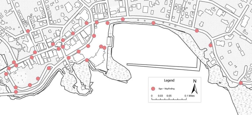
Signage/Wayfinding: Accessible and clear wayfinding signs are essential to ensure visitor
enjoyment of all Sitka has to offer. There are approximately 60 wayfinding signs throughout Sitka,
with 32 signs located in the downtown area. All signs display a map that provides the locations of
amenities and attractions and indicates the viewer’s location with a “You Are Here” symbol. Increased
effort should be made to educate visitors of the wayfinding tools available. This could be
accomplished by a large wayfinding map at passenger hubs that is consistent in design with existing
wayfinding.

Example Wayfinding Sign    O’Connell Bridge Dock Wayfinding Sign

SHORT-TERM TOURISM PLAN                                                                            32
INDIRECT-USE INFRASTRUCTURE & RESOURCES

The impacts to indirect-use infrastructure and resources requires a more specialized/in-depth study
that the scope of this plan did not entail, but recognition of those impacts as well as plans to address
them in the future were important outcomes of this plan. Significant public comment was received
expressing concern about these difficult-to-quantify impacts.

Impacted CBS infrastructure includes roads, water and wastewater systems, solid waste disposal,
trails, and facilities regularly used by cruise passengers (HCH, Library, restrooms, etc.). At this time,
it is anticipated that our infrastructure will be able to handle increased visitor-use based on the
capacity/design of these systems. The biggest unknown is the extent of additional “wear and tear”
resulting from increased cruise passenger use.

Identified community-wide infrastructure and resources that are impacted by cruise visitation include
housing, telecommunications, environment, and the workforce.

FUTURE PLANNING NEEDS
Given the identified needs and impacts, three future planning areas were outlined:

1. Impact Study: A comprehensive impact study should be commissioned to understand the
   impacts of cruise visitation (particularly in the context of rising forecasted passenger volumes) on
   CBS infrastructure and community infrastructure/resources. A main deliverable of this study
   should be opportunities to utilize CPET funds for offsetting identified impacts in an objective,
   formulaic manner.

2. Traffic Study: CBS should request that ADOT perform a system-wide traffic study, and that it be
   performed during the summer months in order to capture peak use data. This will be critical data
   to support ADOT improvements in the future and can also be utilized by CBS in support of
   planning and grant application efforts. The Planning Commission voted 5-0 to support an
   Assembly request of ADOT to conduct this study as soon as possible.

3. Permitting Strategy: Across the board, CBS permitting procedures are disparate across
   departments, complex, and underdeveloped. Tourism adds pressure to permitting needs including
   transportation, vending, parking, and guiding services. Harrigan requires the most immediate
   attention, but all permitting would benefit from a comprehensive review/strategy.

FINDINGS

1. Direct-use infrastructure will face significantly higher use and reliance than in previous years.
   Additional support services to maintain their use will also be required.

2. Keeping up with street maintenance and striping is important to encourage compliance with traffic
   patterns.

3. Improved cell and internet services are needed to accommodate higher visitor numbers in the
   summer.

SHORT-TERM TOURISM PLAN                                                                                     33
You can also read